Bridge Statistics for Amherst, New York (NY)
Condition, Traffic, Stress, Structural Evaluation, Project Costs
- National Bridge Inventory (NBI) Statistics
- 139Number of bridges
- 1,385ft / 422mTotal length
- $423,836,000Total costs
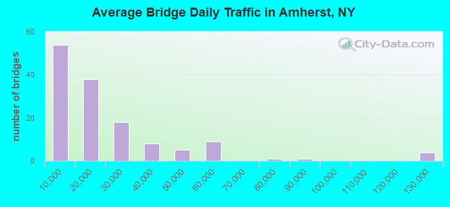
- 2,821,263Total average daily traffic
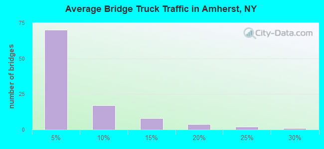
- 109,105Total average daily truck traffic
- National Bridge Inventory (NBI) Registered Bridges for Amherst
- No street view available for this location
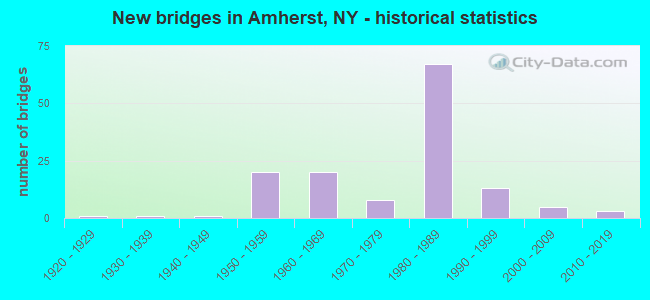
- New bridges - historical statistics
- 11920-1929
- 11930-1939
- 11940-1949
- 201950-1959
- 201960-1969
- 81970-1979
- 671980-1989
- 131990-1999
- 52000-2009
- 32010-2019
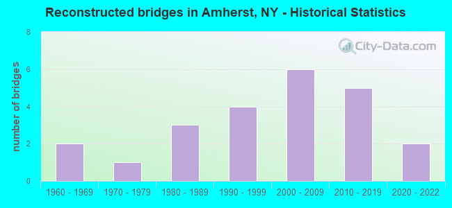
- Reconstructed bridges - Historical Statistics
- 21960-1969
- 11970-1979
- 31980-1989
- 41990-1999
- 62000-2009
- 52010-2019
- 22020-2022
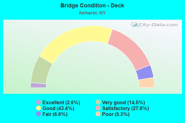
- Bridge Condition - Deck
- 2.6%Excellent
- 14.5%Very good
- 43.4%Good
- 27.6%Satisfactory
- 6.6%Fair
- 5.3%Poor
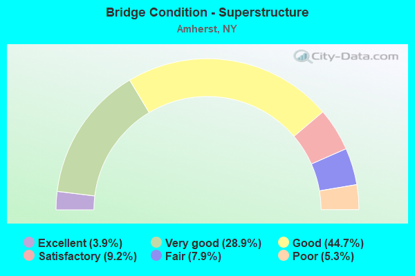
- Bridge Condition - Superstructure
- 3.9%Excellent
- 28.9%Very good
- 44.7%Good
- 9.2%Satisfactory
- 7.9%Fair
- 5.3%Poor
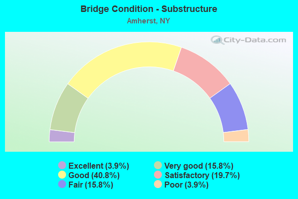
- Bridge Condition - Substructure
- 3.9%Excellent
- 15.8%Very good
- 40.8%Good
- 19.7%Satisfactory
- 15.8%Fair
- 3.9%Poor
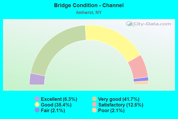
- Bridge Condition - Channel
- 6.3%Excellent
- 41.7%Very good
- 35.4%Good
- 12.5%Satisfactory
- 2.1%Fair
- 2.1%Poor
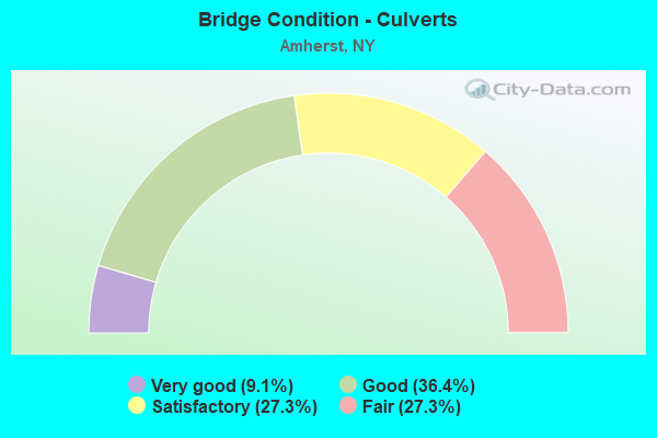
- Bridge Condition - Culverts
- 9.1%Very good
- 36.4%Good
- 27.3%Satisfactory
- 27.3%Fair
Find on map >> Show street view
Structure Number: 1001639, Location: JCT RTS 5 + I-290 (Lat: 42.959247, Lng: -78.766681), Route carried "on" structure: State highway 5, Year Built: 1963, Year Reconstructed: 2006, Status: Open, Structure Length: 6.49m (21.29ft), Average Daily Traffic: 30,768 (year 2020), Truck Traffic: 2%, Average Future Daily Traffic: 30,912 (year 2040), Design Load: HS 20, Features Intersected: 290I290I53011093, RTE I2
Minimum Vertical Clearance: 30+ m (98+ ft), Kilometerpoint: 59.951, Lanes on structure: 7, Lanes under structure: 8, Base Highway Network: Yes, Owner: State Highway Agency, Approaching Roadway Width: 27.4m (89.9ft), Skew: 20 degrees, Material/Design: Steel, Design/Construction: Stringer/Multi-beam, Number Of Spans In Main Unit: 2, Length of Maximum Span: 33.8m (110.9ft), Curb or Sidewalk Widths: Left: 1.2m (3.9ft), Right: 1.2m (3.9ft), Curb-To-Curb Width: 27.4m (89.9ft), Out-to-Out Width: 37.2m (122.0ft)
Condition: Deck: Satisfactory, Superstructure: Poor, Substructure: Good, Operating Rating: 59.0 metric tons, Method Used To Determine Operating Rating: Load Factor (LF), Inventory Rating: 25.4 metric tons, Method Used To Determine Inventory Rating: Load Factor (LF), Structural Evaluation: Meets minimum limits, Deck Geometry: Somewhat better than minimum adequacy, Underclear: Somewhat better than minimum adequacy, Approach Roadway Alignment: Equal to present minimum criteria, Length Of Structure Improvement: 6.49m (21.29ft), Designated Inspection Frequency: Every 24 months, Inspection Date: October 2020, Bridge Improvement Cost: $8,501,000, Roadway Improvement Cost: $4,978,000, Total Project Cost: $13,479,000 ( Estimate for 2021), Deck Structure Type: Concrete Cast-file-Place, Wearing Surface/Protective System: Wearing Surface: Monolithic Concrete
Find on map >> Show street view
Structure Number: 103029, Location: JCT STATE HWYS 324 & 78 (Lat: 42.978194, Lng: -78.696947), Route carried "on" structure: State highway 324, Year Built: 1998, Status: Open, Structure Length: 3.54m (11.61ft), Average Daily Traffic: 19,452 (year 2019), Truck Traffic: 2%, Average Future Daily Traffic: 19,543 (year 2040), Design Load: HS 25 or greater, Features Intersected: RTE 78, TRANSIT ROAD
Minimum Vertical Clearance: 30+ m (98+ ft), Kilometerpoint: 31.311, Lanes on structure: 5, Lanes under structure: 10, Base Highway Network: Yes, Owner: State Highway Agency, Approaching Roadway Width: 19.5m (64.0ft), Skew: 20 degrees, Material/Design: Steel, Design/Construction: Stringer/Multi-beam, Number Of Spans In Main Unit: 1, Length of Maximum Span: 34.1m (111.9ft), Curb or Sidewalk Widths: Left: 1.5m (4.9ft), Right: 1.5m (4.9ft), Curb-To-Curb Width: 19.5m (64.0ft), Out-to-Out Width: 23.2m (76.1ft)
Condition: Deck: Very good, Superstructure: Very good, Substructure: Very good, Operating Rating: 81.6 metric tons, Method Used To Determine Operating Rating: Load Factor (LF), Inventory Rating: 49.0 metric tons, Method Used To Determine Inventory Rating: Load Factor (LF), Structural Evaluation: Equal to present desirable criteria, Deck Geometry: Meets minimum limits, Underclear: Better than present minimum criteria, Approach Roadway Alignment: Equal to present desirable criteria, Length Of Structure Improvement: 3.53m (11.58ft), Designated Inspection Frequency: Every 24 months, Inspection Date: March 2020, Bridge Improvement Cost: $4,906,000, Roadway Improvement Cost: $2,873,000, Total Project Cost: $7,779,000 ( Estimate for 2021), Deck Structure Type: Concrete Cast-file-Place, Wearing Surface/Protective System: Wearing Surface: Integral Concrete, Deck Protection: Epoxy Coated Reinforcing
Find on map >> Show street view
Structure Number: 10303, Location: 4.6 MI S JCT RTS 78 & 263 (Lat: 43.016961, Lng: -78.696994), Route carried "on" structure: State highway 78, Year Built: 2000, Status: Open, Structure Length: 1.83m (6.00ft), Average Daily Traffic: 21,310 (year 2018), Truck Traffic: 3%, Average Future Daily Traffic: 21,410 (year 2040), Design Load: HS 25 or greater, Features Intersected: GOTT CREEK
Minimum Vertical Clearance: 30+ m (98+ ft), Kilometerpoint: 45.985, Lanes on structure: 4, Base Highway Network: Yes, Owner: State Highway Agency, Approaching Roadway Width: 20.4m (66.9ft), Skew: 4 degrees, Material/Design: Prestressed concrete, Design/Construction: Box Beam or Girders - Multiple, Number Of Spans In Main Unit: 1, Length of Maximum Span: 17.1m (56.1ft), Curb or Sidewalk Widths: Left: 2.0m (6.6ft), Right: 2.0m (6.6ft), Curb-To-Curb Width: 20.4m (66.9ft), Out-to-Out Width: 24.8m (81.4ft)
Condition: Deck: Good, Superstructure: Very good, Substructure: Very good, Channel: Very good, Operating Rating: 89.8 metric tons, Method Used To Determine Operating Rating: Load Factor (LF), Inventory Rating: 54.4 metric tons, Method Used To Determine Inventory Rating: Load Factor (LF), Structural Evaluation: Equal to present desirable criteria, Deck Geometry: Superior to present desirable criteria, Waterway Adequacy: Equal to present desirable criteria, Approach Roadway Alignment: Equal to present desirable criteria, Length Of Structure Improvement: 1.82m (5.97ft), Designated Inspection Frequency: Every 24 months, Inspection Date: April 2020, Bridge Improvement Cost: $1,798,000, Roadway Improvement Cost: $1,053,000, Total Project Cost: $2,850,000 ( Estimate for 2021), Wearing Surface/Protective System: Wearing Surface: Integral Concrete
Find on map >> Show street view
Structure Number: 103031, Location: 3.4 MI S JCT RTS 78 & 263 (Lat: 43.034550, Lng: -78.696942), Route carried "on" structure: State highway 78, Year Built: 1993, Status: Open, Structure Length: 1.80m (5.91ft), Average Daily Traffic: 14,331 (year 2020), Truck Traffic: 6%, Average Future Daily Traffic: 14,398 (year 2040), Design Load: HS 25 or greater, Features Intersected: RANSOM CREEK
Minimum Vertical Clearance: 30+ m (98+ ft), Kilometerpoint: 47.932, Lanes on structure: 2, Base Highway Network: Yes, Owner: State Highway Agency, Approaching Roadway Width: 15.8m (51.8ft), Skew: 20 degrees, Material/Design: Prestressed concrete, Design/Construction: Box Beam or Girders - Multiple, Number Of Spans In Main Unit: 1, Length of Maximum Span: 16.4m (53.8ft), Curb or Sidewalk Widths: Left: 0.0m, Right: 1.5m (4.9ft), Curb-To-Curb Width: 15.8m (51.8ft), Out-to-Out Width: 18.1m (59.4ft)
Condition: Deck: Very good, Superstructure: Very good, Substructure: Very good, Channel: Very good, Operating Rating: 57.2 metric tons, Method Used To Determine Operating Rating: Load Factor (LF), Inventory Rating: 53.5 metric tons, Method Used To Determine Inventory Rating: Load Factor (LF), Structural Evaluation: Equal to present desirable criteria, Deck Geometry: Superior to present desirable criteria, Waterway Adequacy: Meets minimum limits, Approach Roadway Alignment: Equal to present desirable criteria, Length Of Structure Improvement: 1.79m (5.87ft), Designated Inspection Frequency: Every 24 months, Inspection Date: April 2020, Bridge Improvement Cost: $856,000, Roadway Improvement Cost: $501,000, Total Project Cost: $1,357,000 ( Estimate for 2021), Wearing Surface/Protective System: Wearing Surface: Monolithic Concrete
Find on map >> Show street view
Structure Number: 103032, Location: 2.5 MI S JCT RTS 78 + 263 (Lat: 43.046733, Lng: -78.696900), Route carried "on" structure: State highway 78, Year Built: 2015, Status: Open, Structure Length: 0.79m (2.59ft), Average Daily Traffic: 14,331 (year 2020), Truck Traffic: 6%, Average Future Daily Traffic: 14,398 (year 2040), Features Intersected: GILL CREEK
Minimum Vertical Clearance: 30+ m (98+ ft), Kilometerpoint: 49.300, Lanes on structure: 2, Base Highway Network: Yes, Owner: State Highway Agency, Approaching Roadway Width: 12.2m (40.0ft), Material/Design: Concrete, Design/Construction: Culvert, Number Of Spans In Main Unit: 1, Length of Maximum Span: 7.3m (24.0ft), Curb-To-Curb Width: 12.2m (40.0ft), Out-to-Out Width: 15.4m (50.5ft)
Condition: Channel: Very good, Culverts: Very good, Operating Rating: 70.8 metric tons, Method Used To Determine Operating Rating: Load Testing, Inventory Rating: 41.7 metric tons, Method Used To Determine Inventory Rating: Load Testing, Structural Evaluation: Equal to present desirable criteria, Deck Geometry: Somewhat better than minimum adequacy, Waterway Adequacy: Equal to present desirable criteria, Approach Roadway Alignment: Equal to present desirable criteria, Length Of Structure Improvement: 0.79m (2.59ft), Designated Inspection Frequency: Every 24 months, Inspection Date: November 2021, Bridge Improvement Cost: $337,000, Roadway Improvement Cost: $197,000, Total Project Cost: $534,000 ( Estimate for 2021)
Find on map >> Show street view
Structure Number: 103034, Location: 0.2 MI N JCT RTS 78 & 263 (Lat: 43.086336, Lng: -78.696906), Route carried "on" structure: State highway 78, Year Built: 1998, Status: Open, Structure Length: 4.45m (14.60ft), Average Daily Traffic: 28,203 (year 2018), Truck Traffic: 4%, Average Future Daily Traffic: 28,335 (year 2040), Design Load: HS 25 or greater, Features Intersected: TONAWANDA CREEK
Minimum Vertical Clearance: 30+ m (98+ ft), Kilometerpoint: 53.676, Lanes on structure: 5, Base Highway Network: Yes, Owner: State Highway Agency, Approaching Roadway Width: 23.8m (78.1ft), Material/Design: Steel, Design/Construction: Stringer/Multi-beam, Number Of Spans In Main Unit: 1, Length of Maximum Span: 43.2m (141.7ft), Curb-To-Curb Width: 23.8m (78.1ft), Out-to-Out Width: 24.4m (80.1ft)
Condition: Deck: Good, Superstructure: Very good, Substructure: Good, Channel: Very good, Operating Rating: 78.9 metric tons, Method Used To Determine Operating Rating: Load Factor (LF), Inventory Rating: 47.2 metric tons, Method Used To Determine Inventory Rating: Load Factor (LF), Structural Evaluation: Better than present minimum criteria, Deck Geometry: Better than present minimum criteria, Waterway Adequacy: Equal to present minimum criteria, Approach Roadway Alignment: Equal to present desirable criteria, Length Of Structure Improvement: 4.45m (14.60ft), Designated Inspection Frequency: Every 24 months, Inspection Date: April 2021, Bridge Improvement Cost: $4,734,000, Roadway Improvement Cost: $2,772,000, Total Project Cost: $7,506,000 ( Estimate for 2021), Deck Structure Type: Concrete Cast-file-Place, Wearing Surface/Protective System: Wearing Surface: Integral Concrete, Deck Protection: Epoxy Coated Reinforcing
Find on map >> Show street view
Structure Number: 1043751, Location: JCT RT 263 + I-290 (Lat: 42.984786, Lng: -78.793942), Route carried "on" structure: Interstate 290, Year Built: 1964, Year Reconstructed: 1985, Status: Open, Structure Length: 5.52m (18.11ft), Average Daily Traffic: 53,023 (year 2015), Truck Traffic: 14%, Features Intersected: 263 263 53011018, RTE 2
Minimum Vertical Clearance: 30+ m (98+ ft), Kilometerpoint: 11.730, Lanes on structure: 4, Lanes under structure: 6, Base Highway Network: Yes, Owner: State Highway Agency, Approaching Roadway Width: 18.9m (62.0ft), Skew: 1 degrees, Material/Design: Steel, Design/Construction: Stringer/Multi-beam, Number Of Spans In Main Unit: 3, Length of Maximum Span: 27.4m (89.9ft), Curb-To-Curb Width: 18.7m (61.4ft), Out-to-Out Width: 19.7m (64.6ft)
Condition: Deck: Satisfactory, Superstructure: Satisfactory, Substructure: Fair, Operating Rating: 35.0 metric tons, Method Used To Determine Operating Rating: Load and Resistance Factor Rating (LRFR) rating reported by rating factor(RF) method using HL-93 loadings, Inventory Rating: 27.2 metric tons, Method Used To Determine Inventory Rating: Load and Resistance Factor Rating (LRFR) rating reported by rating factor(RF) method using HL-93 loadings, Structural Evaluation: Somewhat better than minimum adequacy, Deck Geometry: Meets minimum limits, Underclear: High priority of corrective action, Approach Roadway Alignment: Equal to present desirable criteria, Length Of Structure Improvement: 5.51m (18.08ft), Designated Inspection Frequency: Every 24 months, Inspection Date: June 2021, Bridge Improvement Cost: $3,962,000, Roadway Improvement Cost: $2,320,000, Total Project Cost: $6,282,000 ( Estimate for 2021), Deck Structure Type: Concrete Cast-file-Place, Wearing Surface/Protective System: Wearing Surface: Monolithic Concrete
Find on map >> Show street view
Structure Number: 1043752, Location: JCT RT 263 + I-290 (Lat: 42.984614, Lng: -78.794089), Route carried "on" structure: Interstate 290, Year Built: 1964, Year Reconstructed: 1985, Status: Open, Structure Length: 5.46m (17.91ft), Average Daily Traffic: 44,183 (year 2018), Truck Traffic: 5%, Average Future Daily Traffic: 49,515 (year 2040), Features Intersected: 263 263 53011018, RTE 2
Minimum Vertical Clearance: 30+ m (98+ ft), Kilometerpoint: 11.730, Lanes on structure: 4, Lanes under structure: 6, Base Highway Network: Yes, Owner: State Highway Agency, Approaching Roadway Width: 19.8m (65.0ft), Skew: 1 degrees, Material/Design: Steel, Design/Construction: Stringer/Multi-beam, Number Of Spans In Main Unit: 3, Length of Maximum Span: 27.4m (89.9ft), Curb-To-Curb Width: 19.5m (64.0ft), Out-to-Out Width: 20.8m (68.2ft)
Condition: Deck: Satisfactory, Superstructure: Fair, Substructure: Fair, Operating Rating: 46.7 metric tons, Method Used To Determine Operating Rating: Load and Resistance Factor Rating (LRFR) rating reported by rating factor(RF) method using HL-93 loadings, Inventory Rating: 36.0 metric tons, Method Used To Determine Inventory Rating: Load and Resistance Factor Rating (LRFR) rating reported by rating factor(RF) method using HL-93 loadings, Structural Evaluation: Somewhat better than minimum adequacy, Deck Geometry: Somewhat better than minimum adequacy, Underclear: High priority of corrective action, Approach Roadway Alignment: Equal to present desirable criteria, Length Of Structure Improvement: 5.45m (17.88ft), Designated Inspection Frequency: Every 24 months, Inspection Date: June 2021, Bridge Improvement Cost: $4,149,000, Roadway Improvement Cost: $2,429,000, Total Project Cost: $6,578,000 ( Estimate for 2021), Deck Structure Type: Concrete Cast-file-Place, Wearing Surface/Protective System: Wearing Surface: Monolithic Concrete
Find on map >> Show street view
Structure Number: 104379, Location: 2.6MI SW JCT RTS 263 & 78 (Lat: 43.052917, Lng: -78.728111), Route carried "on" structure: State highway 263, Year Built: 1990, Status: Open, Structure Length: 2.47m (8.10ft), Average Daily Traffic: 18,061 (year 2020), Truck Traffic: 6%, Average Future Daily Traffic: 18,145 (year 2040), Design Load: HS 20, Features Intersected: RANSOM CREEK
Minimum Vertical Clearance: 30+ m (98+ ft), Kilometerpoint: 12.695, Lanes on structure: 4, Base Highway Network: Yes, Owner: State Highway Agency, Approaching Roadway Width: 24.4m (80.1ft), Material/Design: Prestressed concrete, Design/Construction: Box Beam or Girders - Multiple, Number Of Spans In Main Unit: 1, Length of Maximum Span: 23.7m (77.8ft), Curb-To-Curb Width: 24.4m (80.1ft), Out-to-Out Width: 25.2m (82.7ft)
Condition: Deck: Satisfactory, Superstructure: Good, Substructure: Very good, Channel: Very good, Operating Rating: 19.1 metric tons, Method Used To Determine Operating Rating: Load and Resistance Factor Rating (LRFR) rating reported by rating factor(RF) method using HL-93 loadings, Inventory Rating: 13.0 metric tons, Method Used To Determine Inventory Rating: Load and Resistance Factor Rating (LRFR) rating reported by rating factor(RF) method using HL-93 loadings, Structural Evaluation: High priority of corrective action, Deck Geometry: Superior to present desirable criteria, Waterway Adequacy: Equal to present minimum criteria, Approach Roadway Alignment: Equal to present desirable criteria, Length Of Structure Improvement: 2.46m (8.07ft), Designated Inspection Frequency: Every 24 months, Inspection Date: June 2020, Bridge Improvement Cost: $1,859,000, Roadway Improvement Cost: $1,088,000, Total Project Cost: $2,947,000 ( Estimate for 2021), Wearing Surface/Protective System: Wearing Surface: Integral Concrete
Find on map >> Show street view
Structure Number: 104434, Location: JCT RT 277 + I-98 (Lat: 42.951958, Lng: -78.754808), Route carried "on" structure: State highway 277, Year Built: 1954, Year Reconstructed: 1976, Status: Open, Structure Length: 6.04m (19.82ft), Average Daily Traffic: 8,755 (year 2018), Truck Traffic: 3%, Average Future Daily Traffic: 8,796 (year 2040), Design Load: HS 20, Features Intersected: 90IX WB, RTE I90
Minimum Vertical Clearance: 30+ m (98+ ft), Kilometerpoint: 31.199, Lanes on structure: 4, Lanes under structure: 5, Base Highway Network: Yes, Owner: State Toll Authority, Approaching Roadway Width: 14.6m (47.9ft), Material/Design: Steel continuous, Design/Construction: Stringer/Multi-beam, Number Of Spans In Main Unit: 4, Length of Maximum Span: 18.0m (59.1ft), Curb or Sidewalk Widths: Left: 1.6m (5.2ft), Right: 1.6m (5.2ft), Curb-To-Curb Width: 14.7m (48.2ft), Out-to-Out Width: 18.4m (60.4ft)
Condition: Deck: Poor, Superstructure: Fair, Substructure: Fair, Operating Rating: 50.8 metric tons, Method Used To Determine Operating Rating: Load Factor (LF), Inventory Rating: 29.9 metric tons, Method Used To Determine Inventory Rating: Load Factor (LF), Structural Evaluation: Somewhat better than minimum adequacy, Deck Geometry: High priority of replacement, Underclear: High priority of corrective action, Approach Roadway Alignment: Equal to present desirable criteria, Length Of Structure Improvement: 6.03m (19.78ft), Designated Inspection Frequency: Every 24 months, Inspection Date: October 2020, Bridge Improvement Cost: $4,866,000, Roadway Improvement Cost: $2,850,000, Total Project Cost: $7,716,000 ( Estimate for 2021), Deck Structure Type: Concrete Cast-file-Place, Wearing Surface/Protective System: Wearing Surface: Integral Concrete
Find on map >> Show street view
Structure Number: 104504, Location: 0.5 MI W JCT RT 263 +I290 (Lat: 42.990869, Lng: -78.799608), Route carried "on" structure: County highway , Year Built: 1961, Status: Open, Structure Length: 7.92m (25.98ft), Average Daily Traffic: 17,437 (year 2018), Truck Traffic: 2%, Average Future Daily Traffic: 17,518 (year 2040), Features Intersected: 290 290 53011064, RTE 2, Facility Carried by Structure: MAPLE ROAD
Minimum Vertical Clearance: 30+ m (98+ ft), Kilometerpoint: 1.834, Lanes on structure: 4, Lanes under structure: 6, Owner: State Highway Agency, Approaching Roadway Width: 19.8m (65.0ft), Skew: 22 degrees, Material/Design: Steel, Design/Construction: Stringer/Multi-beam, Number Of Spans In Main Unit: 4, Length of Maximum Span: 22.5m (73.8ft), Curb-To-Curb Width: 18.1m (59.4ft), Out-to-Out Width: 19.3m (63.3ft)
Condition: Deck: Satisfactory, Superstructure: Satisfactory, Substructure: Good, Operating Rating: 59.0 metric tons, Method Used To Determine Operating Rating: Load Factor (LF), Inventory Rating: 35.4 metric tons, Method Used To Determine Inventory Rating: Load Factor (LF), Structural Evaluation: Equal to present minimum criteria, Deck Geometry: Somewhat better than minimum adequacy, Underclear: High priority of corrective action, Approach Roadway Alignment: Equal to present desirable criteria, Length Of Structure Improvement: 7.92m (25.98ft), Designated Inspection Frequency: Every 24 months, Inspection Date: October 2020, Bridge Improvement Cost: $5,524,000, Roadway Improvement Cost: $3,235,000, Total Project Cost: $8,759,000 ( Estimate for 2021), Deck Structure Type: Concrete Cast-file-Place, Wearing Surface/Protective System: Wearing Surface: Integral Concrete
Find on map >> Show street view
Structure Number: 104505, Location: 0.5 MI W JCT RT 263 +I290 (Lat: 42.990325, Lng: -78.799111), Route carried "on" structure: Interstate 290, Year Built: 1965, Status: Open, Structure Length: 1.07m (3.51ft), Average Daily Traffic: 72,483 (year 2020), Truck Traffic: 9%, Average Future Daily Traffic: 81,231 (year 2040), Features Intersected: ELLICOTT CRK
Minimum Vertical Clearance: 30+ m (98+ ft), Kilometerpoint: 11.006, Lanes on structure: 6, Base Highway Network: Yes, Owner: State Highway Agency, Approaching Roadway Width: 13.7m (44.9ft), Skew: 22 degrees, Material/Design: Concrete continuous, Design/Construction: Culvert, Number Of Spans In Main Unit: 2, Length of Maximum Span: 4.5m (14.8ft)
Condition: Channel: Very good, Culverts: Fair, Operating Rating: 75.8 metric tons, Method Used To Determine Operating Rating: Field evaluation and documented engineering judgment, Inventory Rating: 32.7 metric tons, Method Used To Determine Inventory Rating: Field evaluation and documented engineering judgment, Structural Evaluation: Somewhat better than minimum adequacy, Waterway Adequacy: Meets minimum limits, Approach Roadway Alignment: Better than present minimum criteria, Length Of Structure Improvement: 1.06m (3.48ft), Designated Inspection Frequency: Every 24 months, Inspection Date: May 2020, Bridge Improvement Cost: $404,000, Roadway Improvement Cost: $237,000, Total Project Cost: $641,000 ( Estimate for 2021), Wearing Surface/Protective System: Wearing Surface: Bituminous
Find on map >> Show street view
Structure Number: 1045061, Location: JCT RT 324 + I-290 (Lat: 42.978636, Lng: -78.783197), Route carried "on" structure: Interstate 290, Year Built: 1964, Year Reconstructed: 2006, Status: Open, Structure Length: 9.42m (30.91ft), Average Daily Traffic: 57,240 (year 2015), Truck Traffic: 8%, Features Intersected: 324 324 53021151 EB, RT
Minimum Vertical Clearance: 30+ m (98+ ft), Kilometerpoint: 12.792, Lanes on structure: 3, Lanes under structure: 7, Base Highway Network: Yes, Owner: State Highway Agency, Approaching Roadway Width: 12.8m (42.0ft), Skew: 5 degrees, Material/Design: Steel, Design/Construction: Stringer/Multi-beam, Number Of Spans In Main Unit: 4, Length of Maximum Span: 24.6m (80.7ft), Curb-To-Curb Width: 12.8m (42.0ft), Out-to-Out Width: 13.7m (44.9ft)
Condition: Deck: Satisfactory, Superstructure: Good, Substructure: Good, Operating Rating: 82.6 metric tons, Method Used To Determine Operating Rating: Load Factor (LF), Inventory Rating: 49.0 metric tons, Method Used To Determine Inventory Rating: Load Factor (LF), Structural Evaluation: Better than present minimum criteria, Deck Geometry: Meets minimum limits, Underclear: High priority of corrective action, Approach Roadway Alignment: Equal to present desirable criteria, Length Of Structure Improvement: 9.41m (30.87ft), Designated Inspection Frequency: Every 24 months, Inspection Date: September 2021, Bridge Improvement Cost: $4,692,000, Roadway Improvement Cost: $2,748,000, Total Project Cost: $7,440,000 ( Estimate for 2021), Deck Structure Type: Concrete Cast-file-Place, Wearing Surface/Protective System: Wearing Surface: Monolithic Concrete
Find on map >> Show street view
Structure Number: 1045062, Location: JCT RT 324 + I-290 (Lat: 42.978664, Lng: -78.783681), Route carried "on" structure: Interstate 290, Year Built: 1964, Year Reconstructed: 2017, Status: Open, Structure Length: 9.57m (31.40ft), Average Daily Traffic: 44,183 (year 2018), Truck Traffic: 6%, Average Future Daily Traffic: 49,515 (year 2040), Features Intersected: 324 324 53021151 EB, RT
Minimum Vertical Clearance: 30+ m (98+ ft), Kilometerpoint: 12.792, Lanes on structure: 3, Lanes under structure: 7, Base Highway Network: Yes, Owner: State Highway Agency, Approaching Roadway Width: 19.5m (64.0ft), Skew: 5 degrees, Material/Design: Steel, Design/Construction: Stringer/Multi-beam, Number Of Spans In Main Unit: 4, Length of Maximum Span: 25.0m (82.0ft), Curb-To-Curb Width: 19.5m (64.0ft), Out-to-Out Width: 20.8m (68.2ft)
Condition: Deck: Satisfactory, Superstructure: Good, Substructure: Good, Operating Rating: 77.1 metric tons, Method Used To Determine Operating Rating: Load Factor (LF), Inventory Rating: 46.3 metric tons, Method Used To Determine Inventory Rating: Load Factor (LF), Structural Evaluation: Better than present minimum criteria, Deck Geometry: Superior to present desirable criteria, Underclear: High priority of corrective action, Approach Roadway Alignment: Equal to present desirable criteria, Length Of Structure Improvement: 9.57m (31.40ft), Designated Inspection Frequency: Every 24 months, Critical Feature Inspection Frequency: Every 12 months, Inspection Date: September 2021, Critical Feature Inspection Date: September 2021, Bridge Improvement Cost: $7,213,000, Roadway Improvement Cost: $4,224,000, Total Project Cost: $11,437,000 ( Estimate for 2021), Deck Structure Type: Concrete Cast-file-Place, Wearing Surface/Protective System: Wearing Surface: Monolithic Concrete
Find on map >> Show street view
Structure Number: 104507, Location: JCT I-290 + I-90 (Lat: 42.956833, Lng: -78.766133), Route carried "on" structure: Ramp Interstate 290, Year Built: 1964, Year Reconstructed: 2006, Status: Open, Structure Length: 6.92m (22.70ft), Average Daily Traffic: 3,059 (year 2018), Truck Traffic: 15%, Average Future Daily Traffic: 3,428 (year 2040), Features Intersected: 290I290I53011095 WB, RTE
Minimum Vertical Clearance: 30+ m (98+ ft), Kilometerpoint: 0.402, Lanes on structure: 2, Lanes under structure: 6, Base Highway Network: Yes, Owner: State Highway Agency, Approaching Roadway Width: 14.3m (46.9ft), Skew: 2 degrees, Material/Design: Steel, Design/Construction: Stringer/Multi-beam, Number Of Spans In Main Unit: 4, Length of Maximum Span: 20.4m (66.9ft), Curb-To-Curb Width: 9.1m (29.9ft), Out-to-Out Width: 10.8m (35.4ft)
Condition: Deck: Satisfactory, Superstructure: Satisfactory, Substructure: Satisfactory, Operating Rating: 68.4 metric tons, Method Used To Determine Operating Rating: Load and Resistance Factor Rating (LRFR) rating reported by rating factor(RF) method using HL-93 loadings, Inventory Rating: 52.8 metric tons, Method Used To Determine Inventory Rating: Load and Resistance Factor Rating (LRFR) rating reported by rating factor(RF) method using HL-93 loadings, Structural Evaluation: Equal to present minimum criteria, Deck Geometry: Meets minimum limits, Underclear: High priority of corrective action, Approach Roadway Alignment: Equal to present minimum criteria, Length Of Structure Improvement: 6.91m (22.67ft), Designated Inspection Frequency: Every 24 months, Inspection Date: May 2021, Bridge Improvement Cost: $2,907,000, Roadway Improvement Cost: $1,702,000, Total Project Cost: $4,609,000 ( Estimate for 2021), Deck Structure Type: Concrete Cast-file-Place, Wearing Surface/Protective System: Wearing Surface: Monolithic Concrete
Find on map >> Show street view
Structure Number: 104589, Location: 0.1MI E.JCT RT 324 & 277 (Lat: 42.978014, Lng: -78.764089), Route carried "on" structure: State highway 324, Year Built: 1989, Status: Open, Structure Length: 3.47m (11.38ft), Average Daily Traffic: 24,793 (year 2019), Truck Traffic: 1%, Average Future Daily Traffic: 24,909 (year 2040), Design Load: HS 20, Features Intersected: ELLICOTT CREEK
Minimum Vertical Clearance: 30+ m (98+ ft), Kilometerpoint: 25.808, Lanes on structure: 4, Base Highway Network: Yes, Owner: State Highway Agency, Approaching Roadway Width: 20.1m (65.9ft), Skew: 20 degrees, Material/Design: Prestressed concrete, Design/Construction: Box Beam or Girders - Multiple, Number Of Spans In Main Unit: 1, Length of Maximum Span: 33.5m (109.9ft), Curb or Sidewalk Widths: Left: 1.5m (4.9ft), Right: 1.5m (4.9ft), Curb-To-Curb Width: 20.1m (65.9ft), Out-to-Out Width: 23.7m (77.8ft)
Condition: Deck: Satisfactory, Superstructure: Good, Substructure: Good, Channel: Very good, Operating Rating: 89.8 metric tons, Method Used To Determine Operating Rating: Load Factor (LF), Inventory Rating: 36.3 metric tons, Method Used To Determine Inventory Rating: Load Factor (LF), Structural Evaluation: Better than present minimum criteria, Deck Geometry: Better than present minimum criteria, Waterway Adequacy: Equal to present minimum criteria, Approach Roadway Alignment: Equal to present desirable criteria, Length Of Structure Improvement: 3.47m (11.38ft), Designated Inspection Frequency: Every 24 months, Inspection Date: May 2020, Bridge Improvement Cost: $2,182,000, Roadway Improvement Cost: $1,278,000, Total Project Cost: $3,460,000 ( Estimate for 2021), Wearing Surface/Protective System: Wearing Surface: Integral Concrete
Find on map >> Show street view
Structure Number: 10717, Location: 1 MI NE JCT SH 263 & I290 (Lat: 42.994744, Lng: -78.787056), Route carried "on" structure: Ramp Other road , Year Built: 1980, Status: Open, Structure Length: 7.50m (24.61ft), Average Daily Traffic: 304 (year 2017), Truck Traffic: 1%, Average Future Daily Traffic: 305 (year 2040), Design Load: HS 20, Features Intersected: 263 263 53011026, RTE 26, Facility Carried by Structure: RAMP O TO SH 263
Minimum Vertical Clearance: 30+ m (98+ ft), Kilometerpoint: 0.225, Lanes on structure: 1, Lanes under structure: 5, Owner: State Agenciy, Approaching Roadway Width: 7.6m (24.9ft), Material/Design: Steel continuous, Design/Construction: Stringer/Multi-beam, Number Of Spans In Main Unit: 2, Length of Maximum Span: 36.8m (120.7ft), Curb-To-Curb Width: 7.4m (24.3ft), Out-to-Out Width: 8.5m (27.9ft)
Condition: Deck: Good, Superstructure: Good, Substructure: Good, Operating Rating: 98.9 metric tons, Method Used To Determine Operating Rating: Field evaluation and documented engineering judgment, Inventory Rating: 32.7 metric tons, Method Used To Determine Inventory Rating: Field evaluation and documented engineering judgment, Structural Evaluation: Better than present minimum criteria, Deck Geometry: Better than present minimum criteria, Underclear: Somewhat better than minimum adequacy, Approach Roadway Alignment: Equal to present desirable criteria, Length Of Structure Improvement: 7.49m (24.57ft), Designated Inspection Frequency: Every 24 months, Inspection Date: September 2021, Bridge Improvement Cost: $2,685,000, Roadway Improvement Cost: $1,572,000, Total Project Cost: $4,258,000 ( Estimate for 2021), Deck Structure Type: Concrete Cast-file-Place, Wearing Surface/Protective System: Wearing Surface: Integral Concrete, Deck Protection: Epoxy Coated Reinforcing
Find on map >> Show street view
Structure Number: 107171, Location: 1.2 MI NE JCT RT 263+I290 (Lat: 42.996175, Lng: -78.785456), Route carried "on" structure: Ramp Other road , Year Built: 1980, Status: Open, Structure Length: 8.08m (26.51ft), Average Daily Traffic: 1,871 (year 2017), Truck Traffic: 2%, Average Future Daily Traffic: 1,879 (year 2040), Design Load: HS 20, Features Intersected: 263 263 53011027, RTE 26, Facility Carried by Structure: RAMP P FROM RT263
Minimum Vertical Clearance: 30+ m (98+ ft), Kilometerpoint: 0.290, Lanes on structure: 2, Lanes under structure: 6, Owner: State Agenciy, Approaching Roadway Width: 11.0m (36.1ft), Material/Design: Steel continuous, Design/Construction: Stringer/Multi-beam, Number Of Spans In Main Unit: 2, Length of Maximum Span: 39.6m (129.9ft), Curb-To-Curb Width: 10.8m (35.4ft), Out-to-Out Width: 11.9m (39.0ft)
Condition: Deck: Good, Superstructure: Good, Substructure: Good, Inventory Rating: 32.7 metric tons, Method Used To Determine Inventory Rating: Field evaluation and documented engineering judgment, Structural Evaluation: Better than present minimum criteria, Deck Geometry: Better than present minimum criteria, Underclear: Equal to present minimum criteria, Approach Roadway Alignment: Equal to present desirable criteria, Length Of Structure Improvement: 8.07m (26.48ft), Designated Inspection Frequency: Every 24 months, Inspection Date: September 2021, Bridge Improvement Cost: $4,081,000, Roadway Improvement Cost: $2,390,000, Total Project Cost: $6,470,000 ( Estimate for 2021), Deck Structure Type: Concrete Cast-file-Place, Wearing Surface/Protective System: Wearing Surface: Integral Concrete, Deck Protection: Epoxy Coated Reinforcing
Find on map >> Show street view
Structure Number: 107172, Location: 0.8 MI SW INT RT 263 +270 (Lat: 43.006003, Lng: -78.773097), Route carried "on" structure: State highway 263, Year Built: 1980, Status: Open, Structure Length: 7.47m (24.51ft), Average Daily Traffic: 13,075 (year 2020), Truck Traffic: 3%, Average Future Daily Traffic: 13,136 (year 2040), Design Load: HS 20, Features Intersected: ELLICOTT CREEK, AMHERST
Minimum Vertical Clearance: 30+ m (98+ ft), Kilometerpoint: 6.179, Lanes on structure: 4, Base Highway Network: Yes, Owner: State Highway Agency, Approaching Roadway Width: 20.4m (66.9ft), Skew: 2 degrees, Material/Design: Steel continuous, Design/Construction: Stringer/Multi-beam, Number Of Spans In Main Unit: 3, Length of Maximum Span: 33.5m (109.9ft), Curb-To-Curb Width: 20.4m (66.9ft), Out-to-Out Width: 21.3m (69.9ft)
Condition: Deck: Good, Superstructure: Good, Substructure: Good, Channel: Very good, Operating Rating: 15.9 metric tons, Method Used To Determine Operating Rating: Load and Resistance Factor Rating (LRFR) rating reported by rating factor(RF) method using HL-93 loadings, Inventory Rating: 12.3 metric tons, Method Used To Determine Inventory Rating: Load and Resistance Factor Rating (LRFR) rating reported by rating factor(RF) method using HL-93 loadings, Structural Evaluation: High priority of corrective action, Deck Geometry: Superior to present desirable criteria, Waterway Adequacy: Equal to present minimum criteria, Approach Roadway Alignment: Equal to present desirable criteria, Length Of Structure Improvement: 7.46m (24.48ft), Designated Inspection Frequency: Every 24 months, Inspection Date: April 2020, Bridge Improvement Cost: $6,253,000, Roadway Improvement Cost: $3,662,000, Total Project Cost: $9,915,000 ( Estimate for 2021), Deck Structure Type: Concrete Cast-file-Place, Wearing Surface/Protective System: Wearing Surface: Monolithic Concrete, Deck Protection: Epoxy Coated Reinforcing
Find on map >> Show street view
Structure Number: 1071851, Location: 1.0 MI NW JCT RT 263+290I (Lat: 42.997264, Lng: -78.807553), Route carried "on" structure: Interstate 290, Year Built: 1983, Status: Open, Structure Length: 5.52m (18.11ft), Average Daily Traffic: 51,953 (year 2012), Truck Traffic: 14%, Design Load: HS 20, Features Intersected: RTE I990, RAMPYELN TO 99
Minimum Vertical Clearance: 5.30m (17.39ft), Kilometerpoint: 9.960, Lanes on structure: 3, Lanes under structure: 4, Base Highway Network: Yes, Owner: State Highway Agency, Approaching Roadway Width: 14.6m (47.9ft), Skew: 4 degrees, Material/Design: Steel, Design/Construction: Stringer/Multi-beam, Number Of Spans In Main Unit: 1, Length of Maximum Span: 54.2m (177.8ft), Curb-To-Curb Width: 16.2m (53.1ft), Out-to-Out Width: 17.1m (56.1ft)
Condition: Deck: Good, Superstructure: Good, Substructure: Very good, Operating Rating: 95.3 metric tons, Method Used To Determine Operating Rating: Load Factor (LF), Inventory Rating: 57.2 metric tons, Method Used To Determine Inventory Rating: Load Factor (LF), Structural Evaluation: Better than present minimum criteria, Deck Geometry: Equal to present minimum criteria, Underclear: Better than present minimum criteria, Approach Roadway Alignment: Equal to present desirable criteria, Length Of Structure Improvement: 5.51m (18.08ft), Designated Inspection Frequency: Every 24 months, Inspection Date: May 2021, Bridge Improvement Cost: $3,692,000, Roadway Improvement Cost: $2,162,000, Total Project Cost: $5,854,000 ( Estimate for 2021), Deck Structure Type: Concrete Cast-file-Place, Wearing Surface/Protective System: Wearing Surface: Integral Concrete, Deck Protection: Epoxy Coated Reinforcing
Find on map >> Show street view
Structure Number: 1071852, Location: 1.0 MI NW JCT RT 263+290I (Lat: 42.996989, Lng: -78.807564), Route carried "on" structure: Interstate 290, Year Built: 1983, Year Reconstructed: 2006, Status: Open, Structure Length: 5.52m (18.11ft), Average Daily Traffic: 36,242 (year 2020), Truck Traffic: 9%, Average Future Daily Traffic: 40,616 (year 2040), Design Load: HS 20, Features Intersected: RTE I990
Minimum Vertical Clearance: 30+ m (98+ ft), Kilometerpoint: 9.960, Lanes on structure: 3, Lanes under structure: 2, Base Highway Network: Yes, Owner: State Highway Agency, Approaching Roadway Width: 14.6m (47.9ft), Skew: 4 degrees, Material/Design: Steel, Design/Construction: Stringer/Multi-beam, Number Of Spans In Main Unit: 1, Length of Maximum Span: 54.2m (177.8ft), Curb-To-Curb Width: 16.2m (53.1ft), Out-to-Out Width: 17.1m (56.1ft)
Condition: Deck: Good, Superstructure: Good, Substructure: Good, Operating Rating: 96.2 metric tons, Method Used To Determine Operating Rating: Load Factor (LF), Inventory Rating: 57.2 metric tons, Method Used To Determine Inventory Rating: Load Factor (LF), Structural Evaluation: Better than present minimum criteria, Deck Geometry: Equal to present minimum criteria, Underclear: Better than present minimum criteria, Approach Roadway Alignment: Equal to present desirable criteria, Length Of Structure Improvement: 5.51m (18.08ft), Designated Inspection Frequency: Every 24 months, Inspection Date: May 2021, Bridge Improvement Cost: $3,692,000, Roadway Improvement Cost: $2,162,000, Total Project Cost: $5,854,000 ( Estimate for 2021), Deck Structure Type: Concrete Cast-file-Place, Wearing Surface/Protective System: Wearing Surface: Integral Concrete, Deck Protection: Epoxy Coated Reinforcing
Find on map >> Show street view
Structure Number: 107186, Location: 1 MI NW JCT SH 263 & I290 (Lat: 42.997464, Lng: -78.808175), Route carried "on" structure: Ramp Interstate 990, Year Built: 1983, Year Reconstructed: 2006, Status: Open, Structure Length: 14.08m (46.19ft), Average Daily Traffic: 40,428 (year 2018), Truck Traffic: 3%, Average Future Daily Traffic: 45,307 (year 2040), Design Load: HS 20, Features Intersected: 290I 290I53011058 WB, RT
Minimum Vertical Clearance: 30+ m (98+ ft), Kilometerpoint: 0.788, Lanes on structure: 2, Lanes under structure: 8, Owner: State Highway Agency, Approaching Roadway Width: 12.8m (42.0ft), Material/Design: Steel continuous, Design/Construction: Stringer/Multi-beam, Number Of Spans In Main Unit: 2, Length of Maximum Span: 72.8m (238.8ft), Curb-To-Curb Width: 12.5m (41.0ft), Out-to-Out Width: 13.4m (44.0ft)
Condition: Deck: Very good, Superstructure: Good, Substructure: Satisfactory, Inventory Rating: 32.7 metric tons, Method Used To Determine Inventory Rating: Field evaluation and documented engineering judgment, Structural Evaluation: Equal to present minimum criteria, Deck Geometry: Superior to present desirable criteria, Underclear: High priority of corrective action, Approach Roadway Alignment: Equal to present desirable criteria, Length Of Structure Improvement: 14.08m (46.19ft), Designated Inspection Frequency: Every 24 months, Inspection Date: September 2021, Bridge Improvement Cost: $6,812,000, Roadway Improvement Cost: $3,989,000, Total Project Cost: $10,801,000 ( Estimate for 2021), Deck Structure Type: Concrete Cast-file-Place, Wearing Surface/Protective System: Wearing Surface: Bituminous, Deck Protection: Epoxy Coated Reinforcing
Find on map >> Show street view
Structure Number: 1071871, Location: 1.5 MI N JCT RTS 290I+263 (Lat: 43.004433, Lng: -78.803767), Route carried "on" structure: Interstate 990, Year Built: 1983, Status: Open, Structure Length: 3.23m (10.60ft), Average Daily Traffic: 25,546 (year 2012), Truck Traffic: 5%, Design Load: HS 20, Features Intersected: CHESTNUT RIDGE RD
Minimum Vertical Clearance: 30+ m (98+ ft), Kilometerpoint: 1.480, Lanes on structure: 4, Lanes under structure: 2, Base Highway Network: Yes, Owner: State Highway Agency, Approaching Roadway Width: 21.3m (69.9ft), Skew: 1 degrees, Material/Design: Steel, Design/Construction: Stringer/Multi-beam, Number Of Spans In Main Unit: 1, Length of Maximum Span: 30.7m (100.7ft), Curb-To-Curb Width: 21.0m (68.9ft), Out-to-Out Width: 21.9m (71.9ft)
Condition: Deck: Good, Superstructure: Good, Substructure: Satisfactory, Operating Rating: 86.2 metric tons, Method Used To Determine Operating Rating: Load Factor (LF), Inventory Rating: 51.7 metric tons, Method Used To Determine Inventory Rating: Load Factor (LF), Structural Evaluation: Equal to present minimum criteria, Deck Geometry: Better than present minimum criteria, Underclear: Equal to present minimum criteria, Approach Roadway Alignment: Equal to present desirable criteria, Length Of Structure Improvement: 3.23m (10.60ft), Designated Inspection Frequency: Every 24 months, Inspection Date: April 2021, Bridge Improvement Cost: $3,181,000, Roadway Improvement Cost: $1,863,000, Total Project Cost: $5,044,000 ( Estimate for 2021), Deck Structure Type: Concrete Cast-file-Place, Wearing Surface/Protective System: Wearing Surface: Integral Concrete, Deck Protection: Epoxy Coated Reinforcing
Find on map >> Show street view
Structure Number: 1071872, Location: 1.5 MI W JCT RTS 290I+263 (Lat: 43.004300, Lng: -78.802803), Route carried "on" structure: Interstate 990, Year Built: 1983, Status: Open, Structure Length: 3.41m (11.19ft), Average Daily Traffic: 20,214 (year 2018), Truck Traffic: 3%, Average Future Daily Traffic: 22,654 (year 2040), Design Load: HS 20, Features Intersected: CHESTNUT RIDGE RD
Minimum Vertical Clearance: 30+ m (98+ ft), Kilometerpoint: 1.818, Lanes on structure: 4, Lanes under structure: 2, Base Highway Network: Yes, Owner: State Highway Agency, Approaching Roadway Width: 21.3m (69.9ft), Material/Design: Steel, Design/Construction: Stringer/Multi-beam, Number Of Spans In Main Unit: 1, Length of Maximum Span: 32.6m (107.0ft), Curb-To-Curb Width: 21.0m (68.9ft), Out-to-Out Width: 21.9m (71.9ft)
Condition: Deck: Good, Superstructure: Good, Substructure: Good, Operating Rating: 84.4 metric tons, Method Used To Determine Operating Rating: Load Factor (LF), Inventory Rating: 49.9 metric tons, Method Used To Determine Inventory Rating: Load Factor (LF), Structural Evaluation: Better than present minimum criteria, Deck Geometry: Better than present minimum criteria, Underclear: Equal to present minimum criteria, Approach Roadway Alignment: Equal to present desirable criteria, Length Of Structure Improvement: 3.41m (11.19ft), Designated Inspection Frequency: Every 24 months, Inspection Date: April 2021, Bridge Improvement Cost: $3,185,000, Roadway Improvement Cost: $1,865,000, Total Project Cost: $5,050,000 ( Estimate for 2021), Deck Structure Type: Concrete Cast-file-Place, Wearing Surface/Protective System: Wearing Surface: Monolithic Concrete, Deck Protection: Epoxy Coated Reinforcing
Find on map >> Show street view
Structure Number: 107188, Location: 1.7 MI N JCT I290 & SH263 (Lat: 43.007683, Lng: -78.803742), Route carried "on" structure: Ramp Interstate 990, Year Built: 1983, Status: Open, Structure Length: 13.41m (44.00ft), Average Daily Traffic: 52,179 (year 2013), Truck Traffic: 4%, Average Future Daily Traffic: 73,051 (year 2033), Design Load: HS 20, Features Intersected: RTE I990, 990I 990I53011
Minimum Vertical Clearance: 30+ m (98+ ft), Kilometerpoint: 1.915, Lanes on structure: 1, Lanes under structure: 7, Base Highway Network: Yes, Owner: State Highway Agency, Approaching Roadway Width: 7.3m (24.0ft), Material/Design: Steel continuous, Design/Construction: Stringer/Multi-beam, Number Of Spans In Main Unit: 3, Length of Maximum Span: 46.6m (152.9ft), Curb-To-Curb Width: 7.3m (24.0ft), Out-to-Out Width: 8.2m (26.9ft)
Condition: Deck: Good, Superstructure: Very good, Substructure: Good, Inventory Rating: 32.7 metric tons, Method Used To Determine Inventory Rating: Field evaluation and documented engineering judgment, Structural Evaluation: Better than present minimum criteria, Deck Geometry: Better than present minimum criteria, Underclear: Somewhat better than minimum adequacy, Approach Roadway Alignment: Equal to present desirable criteria, Length Of Structure Improvement: 13.41m (44.00ft), Designated Inspection Frequency: Every 24 months, Inspection Date: August 2021, Bridge Improvement Cost: $3,922,000, Roadway Improvement Cost: $2,297,000, Total Project Cost: $6,218,000 ( Estimate for 2021), Deck Structure Type: Concrete Cast-file-Place, Wearing Surface/Protective System: Wearing Surface: Integral Concrete, Deck Protection: Epoxy Coated Reinforcing
Find on map >> Show street view
Structure Number: 1072561, Location: 1.2 MI E JCT 62 & I-290 (Lat: 43.006531, Lng: -78.798833), Route carried "on" structure: Ramp Other road 990, Year Built: 1982, Status: Open, Structure Length: 13.90m (45.60ft), Average Daily Traffic: 1,481 (year 2018), Truck Traffic: 1%, Average Future Daily Traffic: 1,716 (year 2040), Design Load: HS 20+Mod, Features Intersected: 952T 952T53011011 NB, RT
Minimum Vertical Clearance: 30+ m (98+ ft), Kilometerpoint: 0.434, Lanes on structure: 1, Lanes under structure: 8, Base Highway Network: Yes, Owner: State Highway Agency, Approaching Roadway Width: 7.3m (24.0ft), Skew: 4 degrees, Material/Design: Steel continuous, Design/Construction: Stringer/Multi-beam, Number Of Spans In Main Unit: 3, Length of Maximum Span: 54.5m (178.8ft), Curb-To-Curb Width: 7.3m (24.0ft), Out-to-Out Width: 8.2m (26.9ft)
Condition: Deck: Satisfactory, Superstructure: Very good, Substructure: Good, Operating Rating: 80.7 metric tons, Method Used To Determine Operating Rating: Load Factor (LF), Inventory Rating: 48.1 metric tons, Method Used To Determine Inventory Rating: Load Factor (LF), Structural Evaluation: Better than present minimum criteria, Deck Geometry: Better than present minimum criteria, Underclear: Equal to present minimum criteria, Waterway Adequacy: Equal to present desirable criteria, Approach Roadway Alignment: Equal to present desirable criteria, Length Of Structure Improvement: 13.89m (45.57ft), Designated Inspection Frequency: Every 24 months, Inspection Date: May 2021, Bridge Improvement Cost: $4,107,000, Roadway Improvement Cost: $2,405,000, Total Project Cost: $6,513,000 ( Estimate for 2021), Deck Structure Type: Concrete Cast-file-Place, Wearing Surface/Protective System: Wearing Surface: Integral Concrete, Deck Protection: Epoxy Coated Reinforcing
Find on map >> Show street view
Structure Number: 1072562, Location: 1.2 MI E JCT 62 & I-290 (Lat: 43.006300, Lng: -78.798828), Route carried "on" structure: Ramp Other road 990, Year Built: 1982, Status: Open, Structure Length: 13.23m (43.41ft), Average Daily Traffic: 1,481 (year 2018), Truck Traffic: 1%, Average Future Daily Traffic: 1,716 (year 2040), Design Load: HS 20+Mod, Features Intersected: 952T 952T53011011, RTE 9
Minimum Vertical Clearance: 30+ m (98+ ft), Kilometerpoint: 0.434, Lanes on structure: 1, Lanes under structure: 8, Base Highway Network: Yes, Owner: State Highway Agency, Approaching Roadway Width: 7.3m (24.0ft), Skew: 4 degrees, Material/Design: Steel continuous, Design/Construction: Stringer/Multi-beam, Number Of Spans In Main Unit: 3, Length of Maximum Span: 47.8m (156.8ft), Curb-To-Curb Width: 7.3m (24.0ft), Out-to-Out Width: 8.2m (26.9ft)
Condition: Deck: Good, Superstructure: Very good, Substructure: Good, Channel: Very good, Operating Rating: 78.9 metric tons, Method Used To Determine Operating Rating: Load Factor (LF), Inventory Rating: 47.2 metric tons, Method Used To Determine Inventory Rating: Load Factor (LF), Structural Evaluation: Better than present minimum criteria, Deck Geometry: Better than present minimum criteria, Underclear: Equal to present minimum criteria, Waterway Adequacy: Equal to present minimum criteria, Approach Roadway Alignment: Equal to present desirable criteria, Length Of Structure Improvement: 13.22m (43.37ft), Designated Inspection Frequency: Every 24 months, Inspection Date: May 2021, Bridge Improvement Cost: $3,908,000, Roadway Improvement Cost: $2,289,000, Total Project Cost: $6,197,000 ( Estimate for 2021), Deck Structure Type: Concrete Cast-file-Place, Wearing Surface/Protective System: Wearing Surface: Integral Concrete, Deck Protection: Epoxy Coated Reinforcing
Find on map >> Show street view
Structure Number: 1072601, Location: 1.7 MI NW INT RTS263+I290 (Lat: 42.993431, Lng: -78.802553), Route carried "on" structure: Interstate 290, Year Built: 1982, Status: Open, Structure Length: 4.45m (14.60ft), Average Daily Traffic: 51,953 (year 2012), Truck Traffic: 14%, Design Load: HS 20, Features Intersected: RTE 952T
Minimum Vertical Clearance: 30+ m (98+ ft), Kilometerpoint: 10.523, Lanes on structure: 5, Lanes under structure: 4, Base Highway Network: Yes, Owner: State Highway Agency, Approaching Roadway Width: 26.8m (87.9ft), Skew: 2 degrees, Material/Design: Steel, Design/Construction: Stringer/Multi-beam, Number Of Spans In Main Unit: 1, Length of Maximum Span: 42.6m (139.8ft), Curb-To-Curb Width: 32.8m (107.6ft), Out-to-Out Width: 33.7m (110.6ft)
Condition: Deck: Satisfactory, Superstructure: Very good, Substructure: Poor, Operating Rating: 94.3 metric tons, Method Used To Determine Operating Rating: Load Factor (LF), Inventory Rating: 56.2 metric tons, Method Used To Determine Inventory Rating: Load Factor (LF), Structural Evaluation: Meets minimum limits, Deck Geometry: Superior to present desirable criteria, Underclear: Equal to present minimum criteria, Approach Roadway Alignment: Equal to present desirable criteria, Length Of Structure Improvement: 4.45m (14.60ft), Designated Inspection Frequency: Every 24 months, Inspection Date: May 2021, Bridge Improvement Cost: $6,693,000, Roadway Improvement Cost: $3,920,000, Total Project Cost: $10,613,000 ( Estimate for 2021), Deck Structure Type: Concrete Cast-file-Place, Wearing Surface/Protective System: Wearing Surface: Monolithic Concrete, Deck Protection: Epoxy Coated Reinforcing
Find on map >> Show street view
Structure Number: 1072602, Location: 1.7 MI NW INT RTS263+I290 (Lat: 42.993242, Lng: -78.802669), Route carried "on" structure: Interstate 290, Year Built: 1982, Status: Open, Structure Length: 4.45m (14.60ft), Average Daily Traffic: 36,242 (year 2020), Truck Traffic: 9%, Average Future Daily Traffic: 40,616 (year 2040), Design Load: HS 20, Features Intersected: RTE 952T
Minimum Vertical Clearance: 30+ m (98+ ft), Kilometerpoint: 10.523, Lanes on structure: 5, Lanes under structure: 4, Base Highway Network: Yes, Owner: State Highway Agency, Approaching Roadway Width: 23.8m (78.1ft), Skew: 2 degrees, Material/Design: Steel, Design/Construction: Stringer/Multi-beam, Number Of Spans In Main Unit: 1, Length of Maximum Span: 42.6m (139.8ft), Curb-To-Curb Width: 24.7m (81.0ft), Out-to-Out Width: 25.6m (84.0ft)
Condition: Deck: Good, Superstructure: Very good, Substructure: Poor, Inventory Rating: 64.4 metric tons, Method Used To Determine Inventory Rating: Load Factor (LF), Structural Evaluation: Meets minimum limits, Deck Geometry: Better than present minimum criteria, Underclear: Equal to present minimum criteria, Approach Roadway Alignment: Equal to present desirable criteria, Length Of Structure Improvement: 4.45m (14.60ft), Designated Inspection Frequency: Every 24 months, Inspection Date: May 2021, Bridge Improvement Cost: $5,084,000, Roadway Improvement Cost: $2,977,000, Total Project Cost: $8,061,000 ( Estimate for 2021), Deck Structure Type: Concrete Cast-file-Place, Wearing Surface/Protective System: Wearing Surface: Monolithic Concrete, Deck Protection: Epoxy Coated Reinforcing
Find on map >> Show street view
Structure Number: 1072631, Location: 1.5 MI N INT I990 & I290 (Lat: 43.018306, Lng: -78.799061), Route carried "on" structure: Interstate 990, Year Built: 1984, Status: Open, Structure Length: 5.79m (19.00ft), Average Daily Traffic: 26,090 (year 2013), Truck Traffic: 6%, Design Load: HS 20+Mod, Features Intersected: RTE 952T
Minimum Vertical Clearance: 30+ m (98+ ft), Kilometerpoint: 3.009, Lanes on structure: 4, Lanes under structure: 5, Base Highway Network: Yes, Owner: State Highway Agency, Approaching Roadway Width: 21.3m (69.9ft), Skew: 5 degrees, Material/Design: Steel, Design/Construction: Stringer/Multi-beam, Number Of Spans In Main Unit: 1, Length of Maximum Span: 56.3m (184.7ft), Curb-To-Curb Width: 23.7m (77.8ft), Out-to-Out Width: 24.6m (80.7ft)
Condition: Deck: Good, Superstructure: Good, Substructure: Satisfactory, Operating Rating: 55.3 metric tons, Method Used To Determine Operating Rating: Load Factor (LF), Inventory Rating: 32.7 metric tons, Method Used To Determine Inventory Rating: Load Factor (LF), Structural Evaluation: Equal to present minimum criteria, Deck Geometry: Superior to present desirable criteria, Underclear: Equal to present minimum criteria, Approach Roadway Alignment: Equal to present desirable criteria, Length Of Structure Improvement: 5.79m (19.00ft), Designated Inspection Frequency: Every 24 months, Inspection Date: April 2021, Bridge Improvement Cost: $5,914,000, Roadway Improvement Cost: $3,463,000, Total Project Cost: $9,377,000 ( Estimate for 2021), Deck Structure Type: Concrete Cast-file-Place, Wearing Surface/Protective System: Wearing Surface: Integral Concrete, Deck Protection: Epoxy Coated Reinforcing
Find on map >> Show street view
Structure Number: 1072632, Location: 1.5 MI N INT I990 & I290 (Lat: 43.017600, Lng: -78.799056), Route carried "on" structure: Interstate 990, Year Built: 1984, Status: Open, Structure Length: 6.10m (20.01ft), Average Daily Traffic: 17,890 (year 2018), Truck Traffic: 3%, Average Future Daily Traffic: 20,049 (year 2040), Design Load: HS 20+Mod, Features Intersected: RTE 952T
Minimum Vertical Clearance: 30+ m (98+ ft), Kilometerpoint: 3.363, Lanes on structure: 3, Lanes under structure: 5, Base Highway Network: Yes, Owner: State Highway Agency, Approaching Roadway Width: 17.1m (56.1ft), Skew: 5 degrees, Material/Design: Steel, Design/Construction: Stringer/Multi-beam, Number Of Spans In Main Unit: 1, Length of Maximum Span: 59.4m (194.9ft), Curb-To-Curb Width: 18.5m (60.7ft), Out-to-Out Width: 19.4m (63.6ft)
Condition: Deck: Good, Superstructure: Very good, Substructure: Good, Operating Rating: 93.4 metric tons, Method Used To Determine Operating Rating: Load Factor (LF), Inventory Rating: 56.2 metric tons, Method Used To Determine Inventory Rating: Load Factor (LF), Structural Evaluation: Better than present minimum criteria, Deck Geometry: Superior to present desirable criteria, Underclear: Somewhat better than minimum adequacy, Approach Roadway Alignment: Equal to present desirable criteria, Length Of Structure Improvement: 6.09m (19.98ft), Designated Inspection Frequency: Every 24 months, Inspection Date: April 2021, Bridge Improvement Cost: $4,865,000, Roadway Improvement Cost: $2,849,000, Total Project Cost: $7,715,000 ( Estimate for 2021), Deck Structure Type: Concrete Cast-file-Place, Wearing Surface/Protective System: Wearing Surface: Epoxy Overlay, Deck Protection: Epoxy Coated Reinforcing
Find on map >> Show street view
Structure Number: 1072641, Location: 1.7MI N INT RTS I990&I290 (Lat: 43.021731, Lng: -78.794731), Route carried "on" structure: Interstate 990, Year Built: 1984, Status: Open, Structure Length: 15.24m (50.00ft), Average Daily Traffic: 19,383 (year 2013), Truck Traffic: 6%, Design Load: HS 20+Mod, Features Intersected: ELLICOTT CREEK, ELLICOTT
Minimum Vertical Clearance: 30+ m (98+ ft), Kilometerpoint: 3.604, Lanes on structure: 3, Base Highway Network: Yes, Owner: State Highway Agency, Approaching Roadway Width: 17.1m (56.1ft), Material/Design: Steel continuous, Design/Construction: Stringer/Multi-beam, Number Of Spans In Main Unit: 2, Length of Maximum Span: 75.8m (248.7ft), Curb-To-Curb Width: 17.1m (56.1ft), Out-to-Out Width: 17.7m (58.1ft)
Condition: Deck: Satisfactory, Superstructure: Good, Substructure: Poor, Channel: Very good, Operating Rating: 69.9 metric tons, Method Used To Determine Operating Rating: Load Factor (LF), Inventory Rating: 41.7 metric tons, Method Used To Determine Inventory Rating: Load Factor (LF), Structural Evaluation: Meets minimum limits, Deck Geometry: Equal to present minimum criteria, Waterway Adequacy: Equal to present desirable criteria, Approach Roadway Alignment: Equal to present desirable criteria, Length Of Structure Improvement: 15.24m (50.00ft), Designated Inspection Frequency: Every 24 months, Inspection Date: May 2021, Bridge Improvement Cost: $9,603,000, Roadway Improvement Cost: $5,624,000, Total Project Cost: $15,227,000 ( Estimate for 2021), Deck Structure Type: Concrete Cast-file-Place, Wearing Surface/Protective System: Wearing Surface: Integral Concrete, Deck Protection: Epoxy Coated Reinforcing
Find on map >> Show street view
Structure Number: 1072642, Location: 1.7MI N INT RTS I990&I290 (Lat: 43.021653, Lng: -78.794078), Route carried "on" structure: Interstate 990, Year Built: 1984, Status: Open, Structure Length: 9.72m (31.89ft), Average Daily Traffic: 17,304 (year 2018), Truck Traffic: 3%, Average Future Daily Traffic: 19,392 (year 2040), Design Load: HS 20+Mod, Features Intersected: ELLICOTT CREEK, ELLICOTT
Minimum Vertical Clearance: 30+ m (98+ ft), Kilometerpoint: 3.958, Lanes on structure: 4, Base Highway Network: Yes, Owner: State Highway Agency, Approaching Roadway Width: 17.1m (56.1ft), Material/Design: Steel continuous, Design/Construction: Stringer/Multi-beam, Number Of Spans In Main Unit: 2, Length of Maximum Span: 48.1m (157.8ft), Curb-To-Curb Width: 19.2m (63.0ft), Out-to-Out Width: 19.8m (65.0ft)
Condition: Deck: Satisfactory, Superstructure: Very good, Substructure: Satisfactory, Channel: Very good, Operating Rating: 77.1 metric tons, Method Used To Determine Operating Rating: Load Factor (LF), Inventory Rating: 46.3 metric tons, Method Used To Determine Inventory Rating: Load Factor (LF), Structural Evaluation: Equal to present minimum criteria, Deck Geometry: Somewhat better than minimum adequacy, Waterway Adequacy: Equal to present minimum criteria, Approach Roadway Alignment: Equal to present desirable criteria, Length Of Structure Improvement: 9.72m (31.89ft), Designated Inspection Frequency: Every 24 months, Underwater Inspection Frequency: Every 60 months, Inspection Date: April 2021, Underwater Inspection Date: July 2017, Bridge Improvement Cost: $7,130,000, Roadway Improvement Cost: $4,175,000, Total Project Cost: $11,305,000 ( Estimate for 2021), Deck Structure Type: Concrete Cast-file-Place, Wearing Surface/Protective System: Wearing Surface: Integral Concrete, Deck Protection: Epoxy Coated Reinforcing
Find on map >> Show street view
Structure Number: 1072651, Location: 1.2 MI W JCT RTS 990I&270 (Lat: 43.023828, Lng: -78.790431), Route carried "on" structure: Interstate 990, Year Built: 1984, Status: Open, Structure Length: 4.57m (14.99ft), Average Daily Traffic: 19,383 (year 2013), Truck Traffic: 6%, Design Load: HS 20+Mod, Features Intersected: CR45-DODGE ROAD
Minimum Vertical Clearance: 30+ m (98+ ft), Kilometerpoint: 4.039, Lanes on structure: 3, Lanes under structure: 2, Base Highway Network: Yes, Owner: State Highway Agency, Approaching Roadway Width: 16.8m (55.1ft), Skew: 5 degrees, Material/Design: Steel, Design/Construction: Stringer/Multi-beam, Number Of Spans In Main Unit: 1, Length of Maximum Span: 42.0m (137.8ft), Curb-To-Curb Width: 16.8m (55.1ft), Out-to-Out Width: 18.4m (60.4ft)
Condition: Deck: Very good, Superstructure: Good, Substructure: Satisfactory, Operating Rating: 97.1 metric tons, Method Used To Determine Operating Rating: Load Factor (LF), Inventory Rating: 58.1 metric tons, Method Used To Determine Inventory Rating: Load Factor (LF), Structural Evaluation: Equal to present minimum criteria, Deck Geometry: Equal to present minimum criteria, Underclear: Somewhat better than minimum adequacy, Approach Roadway Alignment: Equal to present desirable criteria, Length Of Structure Improvement: 4.57m (14.99ft), Designated Inspection Frequency: Every 24 months, Inspection Date: March 2021, Bridge Improvement Cost: $3,630,000, Roadway Improvement Cost: $2,126,000, Total Project Cost: $5,755,000 ( Estimate for 2021), Deck Structure Type: Concrete Cast-file-Place, Wearing Surface/Protective System: Wearing Surface: Integral Concrete, Deck Protection: Epoxy Coated Reinforcing
Find on map >> Show street view
Structure Number: 1072652, Location: 1.1 MI W JCT RTS 990I&270 (Lat: 43.023783, Lng: -78.789556), Route carried "on" structure: Interstate 990, Year Built: 1984, Status: Open, Structure Length: 4.39m (14.40ft), Average Daily Traffic: 17,304 (year 2018), Truck Traffic: 3%, Average Future Daily Traffic: 19,392 (year 2040), Design Load: HS 20+Mod, Features Intersected: CR45-DODGE ROAD
Minimum Vertical Clearance: 30+ m (98+ ft), Kilometerpoint: 4.409, Lanes on structure: 3, Lanes under structure: 2, Base Highway Network: Yes, Owner: State Highway Agency, Approaching Roadway Width: 16.8m (55.1ft), Skew: 5 degrees, Material/Design: Steel, Design/Construction: Stringer/Multi-beam, Number Of Spans In Main Unit: 1, Length of Maximum Span: 42.0m (137.8ft), Curb-To-Curb Width: 16.8m (55.1ft), Out-to-Out Width: 18.4m (60.4ft)
Condition: Deck: Good, Superstructure: Very good, Substructure: Good, Operating Rating: 99.8 metric tons, Method Used To Determine Operating Rating: Load Factor (LF), Inventory Rating: 59.9 metric tons, Method Used To Determine Inventory Rating: Load Factor (LF), Structural Evaluation: Better than present minimum criteria, Deck Geometry: Equal to present minimum criteria, Underclear: Somewhat better than minimum adequacy, Approach Roadway Alignment: Equal to present desirable criteria, Length Of Structure Improvement: 4.38m (14.37ft), Designated Inspection Frequency: Every 24 months, Inspection Date: March 2021, Bridge Improvement Cost: $3,715,000, Roadway Improvement Cost: $2,175,000, Total Project Cost: $5,890,000 ( Estimate for 2021), Deck Structure Type: Concrete Cast-file-Place, Wearing Surface/Protective System: Wearing Surface: Monolithic Concrete, Deck Protection: Epoxy Coated Reinforcing
Find on map >> Show street view
Structure Number: 1072661, Location: 0.8 MI W JCT RTS 990I&270 (Lat: 43.025728, Lng: -78.782386), Route carried "on" structure: Interstate 990, Year Built: 1984, Status: Open, Structure Length: 5.18m (16.99ft), Average Daily Traffic: 19,759 (year 2014), Truck Traffic: 13%, Design Load: HS 20+Mod, Features Intersected: AUDUBON PARKWAY
Minimum Vertical Clearance: 30+ m (98+ ft), Kilometerpoint: 4.666, Lanes on structure: 3, Lanes under structure: 5, Base Highway Network: Yes, Owner: State Highway Agency, Approaching Roadway Width: 16.8m (55.1ft), Material/Design: Steel, Design/Construction: Stringer/Multi-beam, Number Of Spans In Main Unit: 1, Length of Maximum Span: 51.2m (168.0ft), Curb-To-Curb Width: 16.8m (55.1ft), Out-to-Out Width: 17.9m (58.7ft)
Condition: Deck: Good, Superstructure: Good, Substructure: Fair, Operating Rating: 84.4 metric tons, Method Used To Determine Operating Rating: Load Factor (LF), Inventory Rating: 49.9 metric tons, Method Used To Determine Inventory Rating: Load Factor (LF), Structural Evaluation: Somewhat better than minimum adequacy, Deck Geometry: Equal to present minimum criteria, Underclear: Equal to present minimum criteria, Approach Roadway Alignment: Equal to present desirable criteria, Length Of Structure Improvement: 5.18m (16.99ft), Designated Inspection Frequency: Every 24 months, Inspection Date: April 2021, Bridge Improvement Cost: $3,853,000, Roadway Improvement Cost: $2,256,000, Total Project Cost: $6,110,000 ( Estimate for 2021), Deck Structure Type: Concrete Cast-file-Place, Wearing Surface/Protective System: Wearing Surface: Monolithic Concrete, Deck Protection: Epoxy Coated Reinforcing
Find on map >> Show street view
Structure Number: 1072662, Location: 0.8 MI W JCT RTS 990I&270 (Lat: 43.025425, Lng: -78.782267), Route carried "on" structure: Interstate 990, Year Built: 1984, Status: Open, Structure Length: 5.18m (16.99ft), Average Daily Traffic: 17,304 (year 2018), Truck Traffic: 3%, Average Future Daily Traffic: 19,392 (year 2040), Design Load: HS 20+Mod, Features Intersected: AUDUBON PARKWAY
Minimum Vertical Clearance: 30+ m (98+ ft), Kilometerpoint: 5.020, Lanes on structure: 3, Lanes under structure: 5, Base Highway Network: Yes, Owner: State Highway Agency, Approaching Roadway Width: 16.8m (55.1ft), Material/Design: Steel, Design/Construction: Stringer/Multi-beam, Number Of Spans In Main Unit: 1, Length of Maximum Span: 51.2m (168.0ft), Curb-To-Curb Width: 16.8m (55.1ft), Out-to-Out Width: 17.9m (58.7ft)
Condition: Deck: Good, Superstructure: Good, Substructure: Good, Operating Rating: 84.4 metric tons, Method Used To Determine Operating Rating: Load Factor (LF), Inventory Rating: 49.9 metric tons, Method Used To Determine Inventory Rating: Load Factor (LF), Structural Evaluation: Better than present minimum criteria, Deck Geometry: Equal to present minimum criteria, Underclear: Equal to present minimum criteria, Approach Roadway Alignment: Equal to present desirable criteria, Length Of Structure Improvement: 5.18m (16.99ft), Designated Inspection Frequency: Every 24 months, Inspection Date: April 2021, Bridge Improvement Cost: $3,853,000, Roadway Improvement Cost: $2,256,000, Total Project Cost: $6,110,000 ( Estimate for 2021), Deck Structure Type: Concrete Cast-file-Place, Wearing Surface/Protective System: Wearing Surface: Monolithic Concrete, Deck Protection: Epoxy Coated Reinforcing