Bridge Statistics for Allen Park, Michigan (MI)
Condition, Traffic, Stress, Structural Evaluation, Project Costs
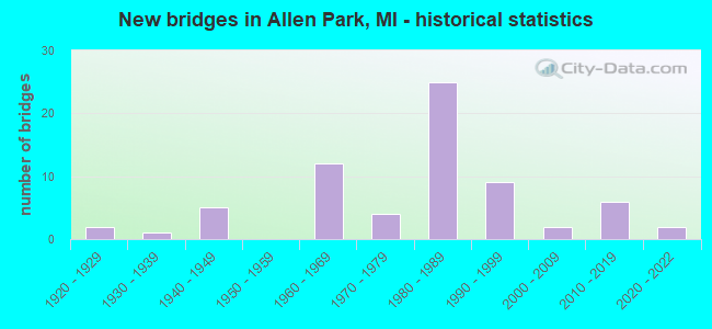
- New bridges - historical statistics
- 21920-1929
- 11930-1939
- 51940-1949
- 121960-1969
- 41970-1979
- 251980-1989
- 91990-1999
- 22000-2009
- 62010-2019
- 22020-2022
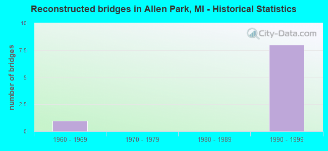
- Reconstructed bridges - Historical Statistics
- 11960-1969
- 01970-1979
- 01980-1989
- 81990-1999
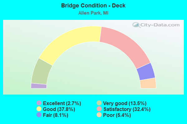
- Bridge Condition - Deck
- 2.7%Excellent
- 13.5%Very good
- 37.8%Good
- 32.4%Satisfactory
- 8.1%Fair
- 5.4%Poor
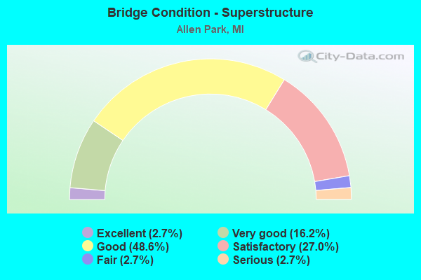
- Bridge Condition - Superstructure
- 2.7%Excellent
- 16.2%Very good
- 48.6%Good
- 27.0%Satisfactory
- 2.7%Fair
- 2.7%Serious
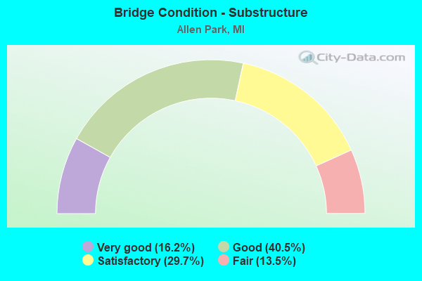
- Bridge Condition - Substructure
- 16.2%Very good
- 40.5%Good
- 29.7%Satisfactory
- 13.5%Fair
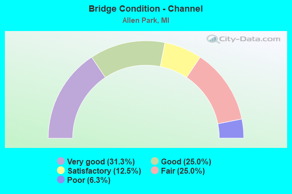
- Bridge Condition - Channel
- 31.3%Very good
- 25.0%Good
- 12.5%Satisfactory
- 25.0%Fair
- 6.3%Poor
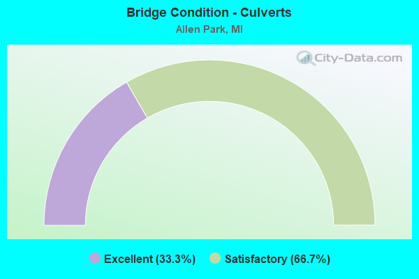
- Bridge Condition - Culverts
- 33.3%Excellent
- 66.7%Satisfactory
Find on map >> Show street view
Structure Number: 139, Location: 4.0 MI SE OF OTTAWA COL (Lat: 42.728528, Lng: -86.056328), Route carried "on" structure: State highway 40, Year Built: 2000, Status: Open, Structure Length: 1.66m (5.45ft), Average Daily Traffic: 11,124 (year 2007), Truck Traffic: 11%, Average Future Daily Traffic: 12,802 (year 2018), Design Load: HS 25 or greater, Features Intersected: S BR MACATAWA RIVER
Minimum Vertical Clearance: 30.48m (100.00ft), Kilometerpoint: 28.971, Lanes on structure: 3, Base Highway Network: Yes (Inventory Route: 78, Subroute: 9), Owner: State Highway Agency, Approaching Roadway Width: 20.4m (66.9ft), Material/Design: Prestressed concrete, Design/Construction: Box Beam or Girders - Single/Spread, Number Of Spans In Main Unit: 1, Length of Maximum Span: 15.4m (50.5ft), Curb-To-Curb Width: 20.4m (66.9ft), Out-to-Out Width: 21.3m (69.9ft)
Condition: Deck: Good, Superstructure: Very good, Substructure: Good, Channel: Fair, Operating Rating: 82.6 metric tons, Method Used To Determine Operating Rating: Load Factor (LF), Inventory Rating: 44.3 metric tons, Method Used To Determine Inventory Rating: Load Factor (LF), Structural Evaluation: Better than present minimum criteria, Deck Geometry: Superior to present desirable criteria, Waterway Adequacy: Equal to present desirable criteria, Approach Roadway Alignment: Equal to present desirable criteria, Designated Inspection Frequency: Every 24 months, Inspection Date: May 2021, Deck Structure Type: Concrete Cast-file-Place, Wearing Surface/Protective System: Wearing Surface: Epoxy Overlay, Deck Protection: Epoxy Coated Reinforcing
Find on map >> Show street view
Structure Number: 1113, Location: COLDWATER TWP SEC 5 (Lat: 41.978133, Lng: -85.028947), Route carried "on" structure: County highway , Year Built: 2009, Status: Open, Structure Length: 3.90m (12.80ft), Average Daily Traffic: 1,848 (year 2008), Truck Traffic: 2%, Average Future Daily Traffic: 2,255 (year 2028), Design Load: HS 20, Features Intersected: COLDWATER RIVER, Facility Carried by Structure: NARROWS ROAD
Minimum Vertical Clearance: 30.48m (100.00ft), Kilometerpoint: 0.969, Lanes on structure: 2, Owner: County Highway Agency, Approaching Roadway Width: 10.4m (34.1ft), Material/Design: Prestressed concrete, Design/Construction: Box Beam or Girders - Multiple, Number Of Spans In Main Unit: 1, Length of Maximum Span: 38.6m (126.6ft), Curb-To-Curb Width: 9.1m (29.9ft), Out-to-Out Width: 10.0m (32.8ft)
Condition: Deck: Good, Superstructure: Good, Substructure: Very good, Channel: Good, Operating Rating: 72.8 metric tons, Method Used To Determine Operating Rating: Load Factor (LF), Inventory Rating: 43.7 metric tons, Method Used To Determine Inventory Rating: Load Factor (LF), Structural Evaluation: Better than present minimum criteria, Deck Geometry: Somewhat better than minimum adequacy, Waterway Adequacy: Superior to present desirable criteria, Approach Roadway Alignment: Equal to present desirable criteria, Designated Inspection Frequency: Every 24 months, Inspection Date: October 2020, Deck Structure Type: Concrete Cast-file-Place, Wearing Surface/Protective System: Wearing Surface: Monolithic Concrete, Deck Protection: Epoxy Coated Reinforcing
Find on map >> Show street view
Structure Number: 1115, Location: BUTLER TWP SEC 35 (Lat: 41.985675, Lng: -84.863342), Route carried "on" structure: County highway 1274, Year Built: 1964, Status: Open, Structure Length: 1.46m (4.79ft), Average Daily Traffic: 610 (year 2004), Truck Traffic: 4%, Average Future Daily Traffic: 811 (year 2024), Design Load: H 20, Features Intersected: SOUTH BR HOG CREEK, Facility Carried by Structure: JONESVILLE ROAD
Minimum Vertical Clearance: 30.48m (100.00ft), Kilometerpoint: 12.999, Lanes on structure: 2, Owner: County Highway Agency, Approaching Roadway Width: 9.1m (29.9ft), Skew: 2 degrees, Material/Design: Prestressed concrete, Design/Construction: Box Beam or Girders - Multiple, Number Of Spans In Main Unit: 1, Length of Maximum Span: 14.3m (46.9ft), Curb-To-Curb Width: 8.5m (27.9ft), Out-to-Out Width: 9.2m (30.2ft)
Condition: Deck: Satisfactory, Superstructure: Fair, Substructure: Good, Channel: Satisfactory, Operating Rating: 51.2 metric tons, Method Used To Determine Operating Rating: Load Factor (LF) rating reported by rating factor (RF) method using MS18 loading, Inventory Rating: 30.8 metric tons, Method Used To Determine Inventory Rating: Load Factor (LF) rating reported by rating factor (RF) method using MS18 loading, Structural Evaluation: Somewhat better than minimum adequacy, Deck Geometry: Somewhat better than minimum adequacy, Waterway Adequacy: Better than present minimum criteria, Approach Roadway Alignment: Equal to present desirable criteria, Designated Inspection Frequency: Every 24 months, Inspection Date: October 2020, Deck Structure Type: Other, Wearing Surface/Protective System: Wearing Surface: Bituminous
Find on map >> Show street view
Structure Number: 1168, Location: MATTESON TWP SEC 35 (Lat: 41.902206, Lng: -85.202350), Route carried "on" structure: County highway , Year Built: 1996, Status: Open, Structure Length: 1.52m (4.99ft), Average Daily Traffic: 119 (year 2004), Truck Traffic: 4%, Average Future Daily Traffic: 175 (year 2024), Design Load: HS 20, Features Intersected: SWAN CREEK DRAIN #5100, Facility Carried by Structure: HORKEY ROAD
Minimum Vertical Clearance: 30.48m (100.00ft), Kilometerpoint: 1.840, Lanes on structure: 2, Owner: County Highway Agency, Approaching Roadway Width: 7.3m (24.0ft), Skew: 1 degrees, Material/Design: Prestressed concrete, Design/Construction: Box Beam or Girders - Multiple, Number Of Spans In Main Unit: 1, Length of Maximum Span: 14.0m (45.9ft), Curb-To-Curb Width: 9.1m (29.9ft), Out-to-Out Width: 9.4m (30.8ft)
Condition: Deck: Good, Superstructure: Satisfactory, Substructure: Good, Channel: Very good, Operating Rating: 73.1 metric tons, Method Used To Determine Operating Rating: Load Factor (LF), Inventory Rating: 43.8 metric tons, Method Used To Determine Inventory Rating: Load Factor (LF), Structural Evaluation: Equal to present minimum criteria, Deck Geometry: Equal to present minimum criteria, Waterway Adequacy: Equal to present desirable criteria, Approach Roadway Alignment: Equal to present desirable criteria, Designated Inspection Frequency: Every 24 months, Inspection Date: October 2020, Deck Structure Type: Concrete Precast Panels, Wearing Surface/Protective System: Wearing Surface: Bituminous
Find on map >> Show street view
Structure Number: 11103, Location: IN ALLEN PARK (Lat: 42.272108, Lng: -83.207422), Route carried "on" structure: Interstate 94, Year Built: 1943, Status: Open, Structure Length: 0.88m (2.89ft), Average Daily Traffic: 47,664 (year 2007), Truck Traffic: 15%, Average Future Daily Traffic: 47,000 (year 2018), Design Load: H 20, Features Intersected: ECORSE CREEK
Minimum Vertical Clearance: 30.48m (100.00ft), Kilometerpoint: 29.111, Lanes on structure: 3, Base Highway Network: Yes (Inventory Route: 157, Subroute: 5), Owner: State Highway Agency, Approaching Roadway Width: 15.2m (49.9ft), Material/Design: Concrete, Design/Construction: Culvert, Number Of Spans In Main Unit: 2, Length of Maximum Span: 4.5m (14.8ft), Curb-To-Curb Width: 14.6m (47.9ft), Out-to-Out Width: 19.6m (64.3ft)
Condition: Channel: Satisfactory, Culverts: Satisfactory, Operating Rating: 97.2 metric tons, Method Used To Determine Operating Rating: Load Factor (LF) rating reported by rating factor (RF) method using MS18 loading, Inventory Rating: 64.2 metric tons, Method Used To Determine Inventory Rating: Load Factor (LF) rating reported by rating factor (RF) method using MS18 loading, Structural Evaluation: Equal to present minimum criteria, Deck Geometry: Meets minimum limits, Waterway Adequacy: Equal to present desirable criteria, Approach Roadway Alignment: Equal to present desirable criteria, Designated Inspection Frequency: Every 24 months, Inspection Date: August 2021, Deck Structure Type: Concrete Cast-file-Place, Wearing Surface/Protective System: Wearing Surface: Integral Concrete
Find on map >> Show street view
Structure Number: 11104, Location: IN ALLEN PARK (Lat: 42.272461, Lng: -83.207872), Route carried "on" structure: Interstate 94, Year Built: 1943, Status: Open, Structure Length: 0.88m (2.89ft), Average Daily Traffic: 47,664 (year 2007), Truck Traffic: 15%, Average Future Daily Traffic: 47,000 (year 2018), Design Load: H 20, Features Intersected: ECORSE CREEK
Minimum Vertical Clearance: 30.48m (100.00ft), Kilometerpoint: 29.042, Lanes on structure: 3, Base Highway Network: Yes (Inventory Route: 158, Subroute: 2), Owner: State Highway Agency, Approaching Roadway Width: 15.2m (49.9ft), Material/Design: Concrete, Design/Construction: Culvert, Number Of Spans In Main Unit: 2, Length of Maximum Span: 4.5m (14.8ft), Curb-To-Curb Width: 14.6m (47.9ft), Out-to-Out Width: 19.6m (64.3ft)
Condition: Channel: Poor, Culverts: Satisfactory, Operating Rating: 94.9 metric tons, Method Used To Determine Operating Rating: Load Factor (LF) rating reported by rating factor (RF) method using MS18 loading, Inventory Rating: 56.7 metric tons, Method Used To Determine Inventory Rating: Load Factor (LF) rating reported by rating factor (RF) method using MS18 loading, Structural Evaluation: Equal to present minimum criteria, Deck Geometry: Meets minimum limits, Waterway Adequacy: Equal to present desirable criteria, Approach Roadway Alignment: Equal to present desirable criteria, Designated Inspection Frequency: Every 24 months, Inspection Date: August 2021, Deck Structure Type: Concrete Cast-file-Place, Wearing Surface/Protective System: Wearing Surface: Integral Concrete
Find on map >> Show street view
Structure Number: 11105, Location: S LTS OF DEARBORN (Lat: 42.295356, Lng: -83.187267), Route carried "on" structure: Interstate 94, Year Built: 1943, Year Reconstructed: 1997, Status: Open, Structure Length: 12.19m (39.99ft), Average Daily Traffic: 49,253 (year 2007), Truck Traffic: 16%, Average Future Daily Traffic: 44,850 (year 2018), Design Load: HS 25 or greater, Features Intersected: ROUGE RIVER
Minimum Vertical Clearance: 30+ m (98+ ft), Kilometerpoint: 32.183, Lanes on structure: 3, Base Highway Network: Yes (Inventory Route: 157, Subroute: 5), Owner: State Highway Agency, Approaching Roadway Width: 34.1m (111.9ft), Skew: 13 degrees, Material/Design: Prestressed concrete, Design/Construction: Stringer/Multi-beam, Number Of Spans In Main Unit: 7, Length of Maximum Span: 24.0m (78.7ft), Curb-To-Curb Width: 18.3m (60.0ft), Out-to-Out Width: 19.3m (63.3ft)
Condition: Deck: Good, Superstructure: Good, Substructure: Fair, Channel: Good, Operating Rating: 57.7 metric tons, Method Used To Determine Operating Rating: Load Factor (LF) rating reported by rating factor (RF) method using MS18 loading, Inventory Rating: 33.7 metric tons, Method Used To Determine Inventory Rating: Load Factor (LF) rating reported by rating factor (RF) method using MS18 loading, Structural Evaluation: Somewhat better than minimum adequacy, Deck Geometry: Better than present minimum criteria, Waterway Adequacy: Equal to present desirable criteria, Approach Roadway Alignment: Equal to present desirable criteria, Designated Inspection Frequency: Every 24 months, Underwater Inspection Frequency: Every 60 months, Inspection Date: July 2021, Underwater Inspection Date: October 2020, Deck Structure Type: Concrete Cast-file-Place, Wearing Surface/Protective System: Wearing Surface: Monolithic Concrete, Deck Protection: Epoxy Coated Reinforcing
Find on map >> Show street view
Structure Number: 11106, Location: ALLEN PARK (Lat: 42.295308, Lng: -83.187636), Route carried "on" structure: Interstate 94, Year Built: 1943, Year Reconstructed: 1997, Status: Open, Structure Length: 12.36m (40.55ft), Average Daily Traffic: 49,253 (year 2007), Truck Traffic: 16%, Average Future Daily Traffic: 44,850 (year 2018), Design Load: HS 25 or greater, Features Intersected: ROUGE RIVER
Minimum Vertical Clearance: 30+ m (98+ ft), Kilometerpoint: 32.082, Lanes on structure: 3, Base Highway Network: Yes (Inventory Route: 158, Subroute: 2), Owner: State Highway Agency, Approaching Roadway Width: 34.1m (111.9ft), Skew: 14 degrees, Material/Design: Prestressed concrete, Design/Construction: Stringer/Multi-beam, Number Of Spans In Main Unit: 7, Length of Maximum Span: 24.3m (79.7ft), Curb-To-Curb Width: 18.3m (60.0ft), Out-to-Out Width: 19.3m (63.3ft)
Condition: Deck: Good, Superstructure: Good, Substructure: Fair, Channel: Good, Operating Rating: 55.1 metric tons, Method Used To Determine Operating Rating: Load Factor (LF) rating reported by rating factor (RF) method using MS18 loading, Inventory Rating: 31.4 metric tons, Method Used To Determine Inventory Rating: Load Factor (LF) rating reported by rating factor (RF) method using MS18 loading, Structural Evaluation: Somewhat better than minimum adequacy, Deck Geometry: Better than present minimum criteria, Waterway Adequacy: Equal to present desirable criteria, Approach Roadway Alignment: Equal to present desirable criteria, Designated Inspection Frequency: Every 24 months, Underwater Inspection Frequency: Every 60 months, Inspection Date: July 2021, Underwater Inspection Date: October 2020, Deck Structure Type: Concrete Cast-file-Place, Wearing Surface/Protective System: Wearing Surface: Monolithic Concrete, Deck Protection: Epoxy Coated Reinforcing
Find on map >> Show street view
Structure Number: 11127, Location: W LTS OF ALLEN PARK (Lat: 42.266106, Lng: -83.231703), Route carried "on" structure: Interstate 94, Year Built: 1975, Year Reconstructed: 2004, Status: Open, Structure Length: 3.81m (12.50ft), Average Daily Traffic: 71,546 (year 2007), Truck Traffic: 10%, Average Future Daily Traffic: 71,250 (year 2018), Design Load: HS 25 or greater, Features Intersected: PELHAM RD
Minimum Vertical Clearance: 30.48m (100.00ft), Kilometerpoint: 26.954, Lanes on structure: 3, Lanes under structure: 4, Base Highway Network: Yes (Inventory Route: 157, Subroute: 5), Owner: State Highway Agency, Approaching Roadway Width: 20.1m (65.9ft), Material/Design: Steel, Design/Construction: Stringer/Multi-beam, Number Of Spans In Main Unit: 1, Length of Maximum Span: 38.1m (125.0ft), Curb-To-Curb Width: 18.2m (59.7ft), Out-to-Out Width: 18.8m (61.7ft)
Condition: Deck: Good, Superstructure: Good, Substructure: Satisfactory, Operating Rating: 97.2 metric tons, Method Used To Determine Operating Rating: Load Factor (LF) rating reported by rating factor (RF) method using MS18 loading, Inventory Rating: 65.4 metric tons, Method Used To Determine Inventory Rating: Load Factor (LF) rating reported by rating factor (RF) method using MS18 loading, Structural Evaluation: Equal to present minimum criteria, Deck Geometry: Better than present minimum criteria, Underclear: Somewhat better than minimum adequacy, Approach Roadway Alignment: Equal to present desirable criteria, Designated Inspection Frequency: Every 24 months, Inspection Date: November 2020, Deck Structure Type: Concrete Cast-file-Place, Wearing Surface/Protective System: Wearing Surface: Monolithic Concrete, Deck Protection: Epoxy Coated Reinforcing
Find on map >> Show street view
Structure Number: 11128, Location: W LTS OF ALLEN PARK (Lat: 42.266458, Lng: -83.231719), Route carried "on" structure: Interstate 94, Year Built: 1975, Year Reconstructed: 2004, Status: Open, Structure Length: 3.82m (12.53ft), Average Daily Traffic: 71,546 (year 2007), Truck Traffic: 10%, Average Future Daily Traffic: 71,250 (year 2018), Design Load: HS 25 or greater, Features Intersected: PELHAM RD
Minimum Vertical Clearance: 30.48m (100.00ft), Kilometerpoint: 26.922, Lanes on structure: 4, Lanes under structure: 4, Base Highway Network: Yes (Inventory Route: 158, Subroute: 2), Owner: State Highway Agency, Approaching Roadway Width: 20.1m (65.9ft), Material/Design: Steel, Design/Construction: Stringer/Multi-beam, Number Of Spans In Main Unit: 1, Length of Maximum Span: 36.1m (118.4ft), Curb-To-Curb Width: 25.7m (84.3ft), Out-to-Out Width: 26.7m (87.6ft)
Condition: Deck: Satisfactory, Superstructure: Good, Substructure: Satisfactory, Operating Rating: 97.2 metric tons, Method Used To Determine Operating Rating: Load Factor (LF) rating reported by rating factor (RF) method using MS18 loading, Inventory Rating: 82.3 metric tons, Method Used To Determine Inventory Rating: Load Factor (LF) rating reported by rating factor (RF) method using MS18 loading, Structural Evaluation: Equal to present minimum criteria, Deck Geometry: Superior to present desirable criteria, Underclear: Somewhat better than minimum adequacy, Approach Roadway Alignment: Equal to present desirable criteria, Designated Inspection Frequency: Every 24 months, Inspection Date: November 2020, Deck Structure Type: Concrete Cast-file-Place, Wearing Surface/Protective System: Wearing Surface: Monolithic Concrete, Deck Protection: Epoxy Coated Reinforcing
Find on map >> Show street view
Structure Number: 11129, Location: IN ALLEN PARK (Lat: 42.276136, Lng: -83.203406), Route carried "on" structure: Interstate 94, Year Built: 1998, Status: Open, Structure Length: 3.43m (11.25ft), Average Daily Traffic: 47,664 (year 2007), Truck Traffic: 15%, Average Future Daily Traffic: 47,000 (year 2018), Design Load: HS 25 or greater, Features Intersected: OUTER DR
Minimum Vertical Clearance: 30.48m (100.00ft), Kilometerpoint: 29.668, Lanes on structure: 3, Lanes under structure: 6, Base Highway Network: Yes (Inventory Route: 157, Subroute: 5), Owner: State Highway Agency, Approaching Roadway Width: 15.2m (49.9ft), Skew: 1 degrees, Material/Design: Prestressed concrete, Design/Construction: Box Beam or Girders - Multiple, Number Of Spans In Main Unit: 1, Length of Maximum Span: 32.3m (106.0ft), Curb-To-Curb Width: 19.2m (63.0ft), Out-to-Out Width: 20.2m (66.3ft)
Condition: Deck: Satisfactory, Superstructure: Good, Substructure: Good, Operating Rating: 91.9 metric tons, Method Used To Determine Operating Rating: Load Factor (LF), Inventory Rating: 49.1 metric tons, Method Used To Determine Inventory Rating: Load Factor (LF), Structural Evaluation: Better than present minimum criteria, Deck Geometry: Superior to present desirable criteria, Underclear: Somewhat better than minimum adequacy, Approach Roadway Alignment: Equal to present desirable criteria, Designated Inspection Frequency: Every 24 months, Inspection Date: August 2021, Deck Structure Type: Concrete Cast-file-Place, Wearing Surface/Protective System: Wearing Surface: Monolithic Concrete, Deck Protection: Epoxy Coated Reinforcing
Find on map >> Show street view
Structure Number: 1113, Location: IN ALLEN PARK (Lat: 42.276300, Lng: -83.203983), Route carried "on" structure: Interstate 94, Year Built: 1996, Status: Open, Structure Length: 3.41m (11.19ft), Average Daily Traffic: 47,664 (year 2007), Truck Traffic: 15%, Average Future Daily Traffic: 47,000 (year 2018), Design Load: HS 25 or greater, Features Intersected: OUTER DR
Minimum Vertical Clearance: 30.48m (100.00ft), Kilometerpoint: 29.576, Lanes on structure: 3, Lanes under structure: 6, Base Highway Network: Yes (Inventory Route: 158, Subroute: 2), Owner: State Highway Agency, Approaching Roadway Width: 15.2m (49.9ft), Skew: 1 degrees, Material/Design: Prestressed concrete, Design/Construction: Box Beam or Girders - Multiple, Number Of Spans In Main Unit: 1, Length of Maximum Span: 32.9m (107.9ft), Curb-To-Curb Width: 19.0m (62.3ft), Out-to-Out Width: 20.0m (65.6ft)
Condition: Deck: Satisfactory, Superstructure: Good, Substructure: Satisfactory, Operating Rating: 93.8 metric tons, Method Used To Determine Operating Rating: Load Factor (LF), Inventory Rating: 52.2 metric tons, Method Used To Determine Inventory Rating: Load Factor (LF), Structural Evaluation: Equal to present minimum criteria, Deck Geometry: Superior to present desirable criteria, Underclear: Equal to present minimum criteria, Approach Roadway Alignment: Equal to present desirable criteria, Designated Inspection Frequency: Every 24 months, Inspection Date: August 2021, Deck Structure Type: Concrete Cast-file-Place, Wearing Surface/Protective System: Wearing Surface: Monolithic Concrete, Deck Protection: Epoxy Coated Reinforcing
Find on map >> Show street view
Structure Number: 11131, Location: IN ALLEN PARK (Lat: 42.285022, Lng: -83.196006), Route carried "on" structure: Interstate 94, Year Built: 1996, Status: Open, Structure Length: 3.01m (9.88ft), Average Daily Traffic: 54,814 (year 2007), Truck Traffic: 14%, Average Future Daily Traffic: 50,000 (year 2018), Design Load: HS 25 or greater, Features Intersected: OAKWOOD BLVD
Minimum Vertical Clearance: 30.48m (100.00ft), Kilometerpoint: 30.828, Lanes on structure: 4, Lanes under structure: 5, Base Highway Network: Yes (Inventory Route: 157, Subroute: 5), Owner: State Highway Agency, Approaching Roadway Width: 15.2m (49.9ft), Material/Design: Prestressed concrete, Design/Construction: Box Beam or Girders - Multiple, Number Of Spans In Main Unit: 1, Length of Maximum Span: 28.9m (94.8ft), Curb-To-Curb Width: 22.1m (72.5ft), Out-to-Out Width: 23.1m (75.8ft)
Condition: Deck: Satisfactory, Superstructure: Good, Substructure: Good, Operating Rating: 92.9 metric tons, Method Used To Determine Operating Rating: Load Factor (LF), Inventory Rating: 47.9 metric tons, Method Used To Determine Inventory Rating: Load Factor (LF), Structural Evaluation: Better than present minimum criteria, Deck Geometry: Equal to present desirable criteria, Underclear: Equal to present minimum criteria, Approach Roadway Alignment: Equal to present desirable criteria, Designated Inspection Frequency: Every 24 months, Inspection Date: August 2021, Deck Structure Type: Concrete Cast-file-Place, Wearing Surface/Protective System: Wearing Surface: Monolithic Concrete, Deck Protection: Epoxy Coated Reinforcing
Find on map >> Show street view
Structure Number: 11132, Location: IN ALLEN PARK (Lat: 42.285256, Lng: -83.196514), Route carried "on" structure: Interstate 94, Year Built: 1996, Status: Open, Structure Length: 3.07m (10.07ft), Average Daily Traffic: 54,814 (year 2007), Truck Traffic: 14%, Average Future Daily Traffic: 50,000 (year 2018), Design Load: HS 25 or greater, Features Intersected: OAKWOOD BLVD
Minimum Vertical Clearance: 30.48m (100.00ft), Kilometerpoint: 30.746, Lanes on structure: 4, Lanes under structure: 5, Base Highway Network: Yes (Inventory Route: 158, Subroute: 2), Owner: State Highway Agency, Approaching Roadway Width: 15.2m (49.9ft), Material/Design: Prestressed concrete, Design/Construction: Box Beam or Girders - Multiple, Number Of Spans In Main Unit: 1, Length of Maximum Span: 29.5m (96.8ft), Curb-To-Curb Width: 22.8m (74.8ft), Out-to-Out Width: 23.7m (77.8ft)
Condition: Deck: Satisfactory, Superstructure: Good, Substructure: Good, Operating Rating: 97.2 metric tons, Method Used To Determine Operating Rating: Load Factor (LF) rating reported by rating factor (RF) method using MS18 loading, Inventory Rating: 50.9 metric tons, Method Used To Determine Inventory Rating: Load Factor (LF) rating reported by rating factor (RF) method using MS18 loading, Structural Evaluation: Better than present minimum criteria, Deck Geometry: Superior to present desirable criteria, Underclear: Somewhat better than minimum adequacy, Approach Roadway Alignment: Equal to present desirable criteria, Designated Inspection Frequency: Every 24 months, Inspection Date: August 2021, Deck Structure Type: Concrete Cast-file-Place, Wearing Surface/Protective System: Wearing Surface: Monolithic Concrete, Deck Protection: Epoxy Coated Reinforcing
Find on map >> Show street view
Structure Number: 11145, Location: IN TAYLOR & ALLEN PARK (Lat: 42.265939, Lng: -83.231694), Route carried "on" structure: Ramp Interstate 94, Year Built: 1981, Status: Open, Structure Length: 3.82m (12.53ft), Average Daily Traffic: 2,500 (year 1988), Truck Traffic: 3%, Average Future Daily Traffic: 640 (year 1977), Design Load: HS 25 or greater, Features Intersected: PELHAM RD
Minimum Vertical Clearance: 30.48m (100.00ft), Kilometerpoint: 0.715, Lanes on structure: 2, Lanes under structure: 5, Owner: State Highway Agency, Approaching Roadway Width: 13.4m (44.0ft), Material/Design: Steel, Design/Construction: Stringer/Multi-beam, Number Of Spans In Main Unit: 1, Length of Maximum Span: 37.1m (121.7ft), Curb-To-Curb Width: 13.4m (44.0ft), Out-to-Out Width: 14.6m (47.9ft)
Condition: Deck: Satisfactory, Superstructure: Very good, Substructure: Good, Operating Rating: 74.5 metric tons, Method Used To Determine Operating Rating: Load Factor (LF) rating reported by rating factor (RF) method using MS18 loading, Inventory Rating: 44.7 metric tons, Method Used To Determine Inventory Rating: Load Factor (LF) rating reported by rating factor (RF) method using MS18 loading, Structural Evaluation: Better than present minimum criteria, Deck Geometry: Superior to present desirable criteria, Underclear: Meets minimum limits, Approach Roadway Alignment: Equal to present desirable criteria, Designated Inspection Frequency: Every 24 months, Inspection Date: November 2020, Deck Structure Type: Concrete Cast-file-Place, Wearing Surface/Protective System: Wearing Surface: Epoxy Overlay, Deck Protection: Epoxy Coated Reinforcing
Find on map >> Show street view
Structure Number: 11146, Location: E OF PELHAM S OF I-94 (Lat: 42.265961, Lng: -83.229378), Route carried "on" structure: Interstate 94, Year Built: 1984, Status: Open, Structure Length: 16.54m (54.27ft), Average Daily Traffic: 1,500 (year 1982), Truck Traffic: 3%, Average Future Daily Traffic: 1,500 (year 1977), Design Load: HS 25 or greater, Features Intersected: PELHAM ROAD
Minimum Vertical Clearance: 30.48m (100.00ft), Kilometerpoint: 0.906, Lanes on structure: 2, Lanes under structure: 1, Base Highway Network: Yes (Inventory Route: 157, Subroute: 1), Owner: State Highway Agency, Approaching Roadway Width: 13.4m (44.0ft), Skew: 2 degrees, Material/Design: Prestressed concrete, Design/Construction: Stringer/Multi-beam, Number Of Spans In Main Unit: 3, Number Of Approach Spans: 9, Length of Maximum Span: 38.4m (126.0ft), Curb-To-Curb Width: 13.4m (44.0ft), Out-to-Out Width: 14.6m (47.9ft)
Condition: Deck: Satisfactory, Superstructure: Satisfactory, Substructure: Good, Operating Rating: 71.9 metric tons, Method Used To Determine Operating Rating: Load Factor (LF), Inventory Rating: 43.0 metric tons, Method Used To Determine Inventory Rating: Load Factor (LF), Structural Evaluation: Equal to present minimum criteria, Deck Geometry: Superior to present desirable criteria, Underclear: Meets minimum limits, Approach Roadway Alignment: Equal to present desirable criteria, Designated Inspection Frequency: Every 24 months, Inspection Date: November 2020, Deck Structure Type: Concrete Cast-file-Place, Wearing Surface/Protective System: Wearing Surface: Epoxy Overlay, Deck Protection: Epoxy Coated Reinforcing
Find on map >> Show street view
Structure Number: 11147, Location: IN ALLEN PARK (Lat: 42.269700, Lng: -83.224600), Route carried "on" structure: Ramp Interstate 94, Year Built: 1985, Status: Open, Structure Length: 40.56m (133.07ft), Average Daily Traffic: 4,150 (year 1982), Truck Traffic: 3%, Average Future Daily Traffic: 4,773 (year 2002), Design Load: HS 25 or greater, Features Intersected: I-94, Facility Carried by Structure: M-39 SB RAMP L
Minimum Vertical Clearance: 30.48m (100.00ft), Kilometerpoint: 0.251, Lanes on structure: 2, Lanes under structure: 11, Owner: State Highway Agency, Approaching Roadway Width: 14.6m (47.9ft), Material/Design: Prestressed concrete, Design/Construction: Stringer/Multi-beam, Number Of Spans In Main Unit: 13, Number Of Approach Spans: 3, Length of Maximum Span: 37.5m (123.0ft), Curb-To-Curb Width: 13.4m (44.0ft), Out-to-Out Width: 14.6m (47.9ft)
Condition: Deck: Good, Superstructure: Satisfactory, Substructure: Satisfactory, Operating Rating: 71.6 metric tons, Method Used To Determine Operating Rating: Load Factor (LF), Inventory Rating: 38.7 metric tons, Method Used To Determine Inventory Rating: Load Factor (LF), Structural Evaluation: Equal to present minimum criteria, Deck Geometry: Superior to present desirable criteria, Underclear: High priority of corrective action, Approach Roadway Alignment: Equal to present desirable criteria, Designated Inspection Frequency: Every 24 months, Inspection Date: August 2020, Deck Structure Type: Concrete Cast-file-Place, Wearing Surface/Protective System: Wearing Surface: Epoxy Overlay, Deck Protection: Epoxy Coated Reinforcing
Find on map >> Show street view
Structure Number: 11148, Location: IN ALLEN PARK (Lat: 42.267100, Lng: -83.222300), Route carried "on" structure: Ramp Interstate 94, Year Built: 1984, Status: Open, Structure Length: 47.77m (156.73ft), Average Daily Traffic: 4,150 (year 1982), Truck Traffic: 3%, Average Future Daily Traffic: 4,150 (year 2010), Design Load: HS 25 or greater, Features Intersected: I-94, Facility Carried by Structure: M-39 SB RAMP K
Minimum Vertical Clearance: 30.48m (100.00ft), Kilometerpoint: 0.399, Lanes on structure: 2, Lanes under structure: 11, Owner: State Highway Agency, Approaching Roadway Width: 14.6m (47.9ft), Material/Design: Prestressed concrete continuous, Design/Construction: Segmental Box Girder, Number Of Spans In Main Unit: 5, Number Of Approach Spans: 10, Length of Maximum Span: 55.1m (180.8ft), Curb-To-Curb Width: 9.8m (32.2ft), Out-to-Out Width: 10.9m (35.8ft)
Condition: Deck: Good, Superstructure: Good, Substructure: Good, Operating Rating: 74.8 metric tons, Method Used To Determine Operating Rating: Load Factor (LF) rating reported by rating factor (RF) method using MS18 loading, Inventory Rating: 33.0 metric tons, Method Used To Determine Inventory Rating: Load Factor (LF) rating reported by rating factor (RF) method using MS18 loading, Structural Evaluation: Better than present minimum criteria, Deck Geometry: Equal to present minimum criteria, Underclear: High priority of corrective action, Approach Roadway Alignment: Equal to present desirable criteria, Designated Inspection Frequency: Every 24 months, Other Special Inspection Frequency: Every 24 months, Inspection Date: August 2020, Other Special Inspection Date: June 2021, Deck Structure Type: Concrete Cast-file-Place, Wearing Surface/Protective System: Wearing Surface: Epoxy Overlay, Deck Protection: Epoxy Coated Reinforcing
Find on map >> Show street view
Structure Number: 11149, Location: IN ALLEN PARK (Lat: 42.266561, Lng: -83.223119), Route carried "on" structure: Ramp Interstate 94, Year Built: 1984, Status: Open, Structure Length: 14.78m (48.49ft), Average Daily Traffic: 1,500 (year 1982), Truck Traffic: 3%, Average Future Daily Traffic: 1,500 (year 1977), Design Load: HS 25 or greater, Features Intersected: M-39
Minimum Vertical Clearance: 30.48m (100.00ft), Kilometerpoint: 0.478, Lanes on structure: 2, Lanes under structure: 8, Owner: State Highway Agency, Approaching Roadway Width: 14.6m (47.9ft), Material/Design: Prestressed concrete, Design/Construction: Stringer/Multi-beam, Number Of Spans In Main Unit: 4, Number Of Approach Spans: 7, Length of Maximum Span: 23.7m (77.8ft), Curb-To-Curb Width: 13.4m (44.0ft), Out-to-Out Width: 14.6m (47.9ft)
Condition: Deck: Fair, Superstructure: Satisfactory, Substructure: Fair, Operating Rating: 59.3 metric tons, Method Used To Determine Operating Rating: Load Factor (LF), Inventory Rating: 35.5 metric tons, Method Used To Determine Inventory Rating: Load Factor (LF), Structural Evaluation: Somewhat better than minimum adequacy, Deck Geometry: Superior to present desirable criteria, Underclear: High priority of corrective action, Approach Roadway Alignment: Equal to present desirable criteria, Designated Inspection Frequency: Every 24 months, Other Special Inspection Frequency: Every 6 months, Inspection Date: November 2020, Other Special Inspection Date: November 2021, Deck Structure Type: Concrete Cast-file-Place, Wearing Surface/Protective System: Wearing Surface: Epoxy Overlay, Deck Protection: Epoxy Coated Reinforcing
Find on map >> Show street view
Structure Number: 1115, Location: IN ALLEN PARK (Lat: 42.267261, Lng: -83.222142), Route carried "on" structure: Interstate 94, Year Built: 1984, Status: Open, Structure Length: 27.41m (89.93ft), Average Daily Traffic: 71,546 (year 2007), Truck Traffic: 15%, Average Future Daily Traffic: 47,000 (year 2018), Design Load: HS 25 or greater, Features Intersected: M-39
Minimum Vertical Clearance: 30.48m (100.00ft), Kilometerpoint: 27.611, Lanes on structure: 2, Lanes under structure: 9, Base Highway Network: Yes (Inventory Route: 157, Subroute: 5), Owner: State Highway Agency, Approaching Roadway Width: 14.6m (47.9ft), Material/Design: Prestressed concrete, Design/Construction: Stringer/Multi-beam, Number Of Spans In Main Unit: 7, Number Of Approach Spans: 12, Length of Maximum Span: 26.6m (87.3ft), Curb-To-Curb Width: 18.9m (62.0ft), Out-to-Out Width: 20.0m (65.6ft)
Condition: Deck: Satisfactory, Superstructure: Satisfactory, Substructure: Good, Operating Rating: 56.6 metric tons, Method Used To Determine Operating Rating: Load Factor (LF), Inventory Rating: 33.9 metric tons, Method Used To Determine Inventory Rating: Load Factor (LF), Structural Evaluation: Equal to present minimum criteria, Deck Geometry: Superior to present desirable criteria, Underclear: High priority of corrective action, Approach Roadway Alignment: Equal to present desirable criteria, Designated Inspection Frequency: Every 24 months, Inspection Date: November 2020, Deck Structure Type: Concrete Cast-file-Place, Wearing Surface/Protective System: Wearing Surface: Epoxy Overlay, Deck Protection: Epoxy Coated Reinforcing
Find on map >> Show street view
Structure Number: 11151, Location: IN ALLEN PARK (Lat: 42.267583, Lng: -83.221961), Route carried "on" structure: Interstate 94, Year Built: 1984, Status: Open, Structure Length: 25.77m (84.55ft), Average Daily Traffic: 71,546 (year 2007), Truck Traffic: 15%, Average Future Daily Traffic: 47,000 (year 2018), Design Load: HS 25 or greater, Features Intersected: M-39
Minimum Vertical Clearance: 30.48m (100.00ft), Kilometerpoint: 27.566, Lanes on structure: 4, Lanes under structure: 9, Base Highway Network: Yes (Inventory Route: 158, Subroute: 2), Owner: State Highway Agency, Approaching Roadway Width: 14.6m (47.9ft), Material/Design: Prestressed concrete, Design/Construction: Stringer/Multi-beam, Number Of Spans In Main Unit: 4, Number Of Approach Spans: 17, Length of Maximum Span: 26.2m (86.0ft), Curb-To-Curb Width: 14.7m (48.2ft), Out-to-Out Width: 22.0m (72.2ft)
Condition: Deck: Satisfactory, Superstructure: Good, Substructure: Satisfactory, Operating Rating: 54.8 metric tons, Method Used To Determine Operating Rating: Load Factor (LF) rating reported by rating factor (RF) method using MS18 loading, Inventory Rating: 32.7 metric tons, Method Used To Determine Inventory Rating: Load Factor (LF) rating reported by rating factor (RF) method using MS18 loading, Structural Evaluation: Equal to present minimum criteria, Deck Geometry: High priority of replacement, Underclear: Equal to present minimum criteria, Approach Roadway Alignment: Equal to present desirable criteria, Designated Inspection Frequency: Every 24 months, Inspection Date: November 2020, Deck Structure Type: Concrete Cast-file-Place, Wearing Surface/Protective System: Wearing Surface: Epoxy Overlay, Deck Protection: Epoxy Coated Reinforcing
Find on map >> Show street view
Structure Number: 11152, Location: RAMP TO SB M-39 (Lat: 42.268964, Lng: -83.223972), Route carried "on" structure: Ramp Interstate 94, Year Built: 1985, Status: Open, Structure Length: 28.25m (92.68ft), Average Daily Traffic: 1,500 (year 1982), Truck Traffic: 3%, Average Future Daily Traffic: 1,500 (year 1977), Design Load: HS 25 or greater, Features Intersected: M-39
Minimum Vertical Clearance: 30.48m (100.00ft), Kilometerpoint: 0.571, Lanes on structure: 1, Lanes under structure: 6, Owner: State Highway Agency, Approaching Roadway Width: 14.6m (47.9ft), Material/Design: Prestressed concrete, Design/Construction: Stringer/Multi-beam, Number Of Spans In Main Unit: 4, Number Of Approach Spans: 21, Length of Maximum Span: 34.0m (111.5ft), Curb-To-Curb Width: 9.7m (31.8ft), Out-to-Out Width: 10.9m (35.8ft)
Condition: Deck: Good, Superstructure: Good, Substructure: Satisfactory, Operating Rating: 59.9 metric tons, Method Used To Determine Operating Rating: Load Factor (LF) rating reported by rating factor (RF) method using MS18 loading, Inventory Rating: 36.0 metric tons, Method Used To Determine Inventory Rating: Load Factor (LF) rating reported by rating factor (RF) method using MS18 loading, Structural Evaluation: Equal to present minimum criteria, Deck Geometry: Superior to present desirable criteria, Underclear: Meets minimum limits, Approach Roadway Alignment: Equal to present desirable criteria, Designated Inspection Frequency: Every 24 months, Inspection Date: November 2020, Deck Structure Type: Concrete Cast-file-Place, Wearing Surface/Protective System: Wearing Surface: Epoxy Overlay, Deck Protection: Epoxy Coated Reinforcing
Find on map >> Show street view
Structure Number: 11153, Location: RAMP TO PELHAM RD (Lat: 42.269072, Lng: -83.223942), Route carried "on" structure: Ramp Interstate 94, Year Built: 1985, Status: Open, Structure Length: 8.37m (27.46ft), Average Daily Traffic: 1,500 (year 1982), Truck Traffic: 3%, Average Future Daily Traffic: 1,500 (year 1977), Design Load: HS 25 or greater, Features Intersected: M-39
Minimum Vertical Clearance: 30.48m (100.00ft), Kilometerpoint: 0.053, Lanes on structure: 1, Lanes under structure: 6, Owner: State Highway Agency, Approaching Roadway Width: 14.6m (47.9ft), Material/Design: Prestressed concrete, Design/Construction: Stringer/Multi-beam, Number Of Spans In Main Unit: 4, Length of Maximum Span: 26.9m (88.3ft), Curb-To-Curb Width: 10.9m (35.8ft), Out-to-Out Width: 12.2m (40.0ft)
Condition: Deck: Good, Superstructure: Good, Substructure: Good, Operating Rating: 65.4 metric tons, Method Used To Determine Operating Rating: Load Factor (LF), Inventory Rating: 39.2 metric tons, Method Used To Determine Inventory Rating: Load Factor (LF), Structural Evaluation: Better than present minimum criteria, Deck Geometry: Superior to present desirable criteria, Underclear: Equal to present minimum criteria, Approach Roadway Alignment: Equal to present desirable criteria, Designated Inspection Frequency: Every 24 months, Inspection Date: November 2020, Deck Structure Type: Concrete Cast-file-Place, Wearing Surface/Protective System: Wearing Surface: Epoxy Overlay, Deck Protection: Epoxy Coated Reinforcing
Find on map >> Show street view
Structure Number: 11154, Location: AT I-94 & M-39 INTRCHG (Lat: 42.269475, Lng: -83.223769), Route carried "on" structure: Ramp State highway 94, Year Built: 1985, Status: Open, Structure Length: 9.91m (32.51ft), Average Daily Traffic: 1,500 (year 1982), Truck Traffic: 3%, Average Future Daily Traffic: 1,500 (year 1977), Design Load: HS 25 or greater, Features Intersected: M-39, Facility Carried by Structure: VAN BORN RD
Minimum Vertical Clearance: 30.48m (100.00ft), Kilometerpoint: 0.307, Lanes on structure: 3, Lanes under structure: 7, Owner: State Highway Agency, Approaching Roadway Width: 14.6m (47.9ft), Skew: 30 degrees, Material/Design: Prestressed concrete, Design/Construction: Stringer/Multi-beam, Number Of Spans In Main Unit: 3, Number Of Approach Spans: 4, Length of Maximum Span: 22.5m (73.8ft), Curb-To-Curb Width: 18.9m (62.0ft), Out-to-Out Width: 20.2m (66.3ft)
Condition: Deck: Fair, Superstructure: Good, Substructure: Good, Operating Rating: 66.7 metric tons, Method Used To Determine Operating Rating: Load Factor (LF) rating reported by rating factor (RF) method using MS18 loading, Inventory Rating: 39.9 metric tons, Method Used To Determine Inventory Rating: Load Factor (LF) rating reported by rating factor (RF) method using MS18 loading, Structural Evaluation: Better than present minimum criteria, Deck Geometry: Superior to present desirable criteria, Underclear: High priority of corrective action, Approach Roadway Alignment: Equal to present desirable criteria, Designated Inspection Frequency: Every 24 months, Inspection Date: November 2020, Deck Structure Type: Concrete Cast-file-Place, Wearing Surface/Protective System: Wearing Surface: Epoxy Overlay, Deck Protection: Epoxy Coated Reinforcing
Find on map >> Show street view
Structure Number: 11156, Location: AT VAN BORN IN ALLEN PARK (Lat: 42.269892, Lng: -83.221894), Route carried "on" structure: Ramp Interstate 94, Year Built: 1985, Status: Open, Structure Length: 5.06m (16.60ft), Average Daily Traffic: 1,500 (year 1982), Truck Traffic: 3%, Average Future Daily Traffic: 1,500 (year 1983), Design Load: HS 25 or greater, Features Intersected: I-94 EB RAMPS B & G, Facility Carried by Structure: RAMP J TO M-39
Minimum Vertical Clearance: 30.48m (100.00ft), Kilometerpoint: 16.934, Lanes on structure: 2, Lanes under structure: 3, Owner: State Highway Agency, Approaching Roadway Width: 10.9m (35.8ft), Material/Design: Prestressed concrete, Design/Construction: Stringer/Multi-beam, Number Of Spans In Main Unit: 2, Length of Maximum Span: 26.8m (87.9ft), Curb-To-Curb Width: 10.9m (35.8ft), Out-to-Out Width: 12.1m (39.7ft)
Condition: Deck: Satisfactory, Superstructure: Good, Substructure: Very good, Operating Rating: 88.1 metric tons, Method Used To Determine Operating Rating: Load Factor (LF), Inventory Rating: 52.8 metric tons, Method Used To Determine Inventory Rating: Load Factor (LF), Structural Evaluation: Better than present minimum criteria, Deck Geometry: Better than present minimum criteria, Underclear: Meets minimum limits, Approach Roadway Alignment: Equal to present desirable criteria, Designated Inspection Frequency: Every 24 months, Inspection Date: November 2020, Deck Structure Type: Concrete Cast-file-Place, Wearing Surface/Protective System: Wearing Surface: Epoxy Overlay, Deck Protection: Epoxy Coated Reinforcing
Find on map >> Show street view
Structure Number: 1167, Location: IN ALLEN PARK (Lat: 42.273761, Lng: -83.220403), Route carried "on" structure: State highway 39, Year Built: 1963, Status: Open, Structure Length: 1.00m (3.28ft), Average Daily Traffic: 92,920 (year 2007), Truck Traffic: 4%, Average Future Daily Traffic: 103,290 (year 2018), Design Load: HS 20, Features Intersected: ECORSE CREEK
Minimum Vertical Clearance: 30.48m (100.00ft), Kilometerpoint: 5.240, Lanes on structure: 7, Base Highway Network: Yes (Inventory Route: 159, Subroute: 8), Owner: State Highway Agency, Approaching Roadway Width: 15.8m (51.8ft), Skew: 34 degrees, Material/Design: Steel, Design/Construction: Stringer/Multi-beam, Number Of Spans In Main Unit: 1, Length of Maximum Span: 10.0m (32.8ft), Curb-To-Curb Width: 35.4m (116.1ft), Out-to-Out Width: 36.1m (118.4ft)
Condition: Deck: Satisfactory, Superstructure: Satisfactory, Substructure: Satisfactory, Channel: Fair, Operating Rating: 84.2 metric tons, Method Used To Determine Operating Rating: Load Factor (LF) rating reported by rating factor (RF) method using MS18 loading, Inventory Rating: 50.5 metric tons, Method Used To Determine Inventory Rating: Load Factor (LF) rating reported by rating factor (RF) method using MS18 loading, Structural Evaluation: Equal to present minimum criteria, Deck Geometry: Superior to present desirable criteria, Waterway Adequacy: Equal to present minimum criteria, Approach Roadway Alignment: Equal to present desirable criteria, Designated Inspection Frequency: Every 24 months, Inspection Date: October 2020, Deck Structure Type: Concrete Cast-file-Place, Wearing Surface/Protective System: Wearing Surface: Latex Concrete
Find on map >> Show street view
Structure Number: 11679, Location: IN ALLEN PARK (Lat: 42.277583, Lng: -83.217242), Route carried "on" structure: County highway 2057, Year Built: 1964, Year Reconstructed: 2001, Status: Open, Structure Length: 3.23m (10.60ft), Average Daily Traffic: 25,600 (year 1978), Truck Traffic: 3%, Average Future Daily Traffic: 25,600 (year 1977), Design Load: HS 20, Features Intersected: M-39, Facility Carried by Structure: OUTER DRIVE S EB
Minimum Vertical Clearance: 30.48m (100.00ft), Kilometerpoint: 6.846, Lanes on structure: 5, Lanes under structure: 6, Base Highway Network: Yes (Inventory Route: 471, Subroute: 71), Owner: State Highway Agency, Approaching Roadway Width: 20.7m (67.9ft), Skew: 20 degrees, Material/Design: Steel continuous, Design/Construction: Stringer/Multi-beam, Number Of Spans In Main Unit: 2, Length of Maximum Span: 15.8m (51.8ft), Curb-To-Curb Width: 20.7m (67.9ft), Out-to-Out Width: 23.8m (78.1ft)
Condition: Deck: Good, Superstructure: Satisfactory, Substructure: Fair, Operating Rating: 55.0 metric tons, Method Used To Determine Operating Rating: Load Factor (LF), Inventory Rating: 32.9 metric tons, Method Used To Determine Inventory Rating: Load Factor (LF), Structural Evaluation: Somewhat better than minimum adequacy, Deck Geometry: Somewhat better than minimum adequacy, Underclear: High priority of corrective action, Approach Roadway Alignment: Equal to present desirable criteria, Designated Inspection Frequency: Every 24 months, Inspection Date: November 2021, Deck Structure Type: Concrete Cast-file-Place, Wearing Surface/Protective System: Wearing Surface: Monolithic Concrete, Deck Protection: Epoxy Coated Reinforcing
Find on map >> Show street view
Structure Number: 1168, Location: IN ALLEN PARK (Lat: 42.277767, Lng: -83.217078), Route carried "on" structure: County highway 2057, Year Built: 1964, Year Reconstructed: 2001, Status: Open, Structure Length: 3.23m (10.60ft), Average Daily Traffic: 25,600 (year 1978), Truck Traffic: 3%, Average Future Daily Traffic: 25,600 (year 1977), Design Load: HS 20, Features Intersected: M-39, Facility Carried by Structure: OUTER DRIVE S WB
Minimum Vertical Clearance: 30.48m (100.00ft), Kilometerpoint: 2.161, Lanes on structure: 5, Lanes under structure: 6, Base Highway Network: Yes (Inventory Route: 166, Subroute: 1), Owner: State Highway Agency, Approaching Roadway Width: 20.7m (67.9ft), Skew: 20 degrees, Material/Design: Steel continuous, Design/Construction: Stringer/Multi-beam, Number Of Spans In Main Unit: 2, Length of Maximum Span: 15.8m (51.8ft), Curb or Sidewalk Widths: Left: 2.0m (6.6ft), Right: 0.0m, Curb-To-Curb Width: 20.7m (67.9ft), Out-to-Out Width: 23.8m (78.1ft)
Condition: Deck: Good, Superstructure: Satisfactory, Substructure: Fair, Operating Rating: 55.1 metric tons, Method Used To Determine Operating Rating: Load Factor (LF), Inventory Rating: 33.0 metric tons, Method Used To Determine Inventory Rating: Load Factor (LF), Structural Evaluation: Somewhat better than minimum adequacy, Deck Geometry: Somewhat better than minimum adequacy, Underclear: High priority of corrective action, Approach Roadway Alignment: Equal to present desirable criteria, Designated Inspection Frequency: Every 24 months, Inspection Date: November 2021, Deck Structure Type: Concrete Cast-file-Place, Wearing Surface/Protective System: Wearing Surface: Monolithic Concrete, Deck Protection: Epoxy Coated Reinforcing
Find on map >> Show street view
Structure Number: 11681, Location: IN ALLEN PARK (Lat: 42.284300, Lng: -83.211461), Route carried "on" structure: City street 2000, Year Built: 1964, Year Reconstructed: 2001, Status: Open, Structure Length: 5.63m (18.47ft), Average Daily Traffic: 7,500 (year 1988), Truck Traffic: 3%, Average Future Daily Traffic: 190 (year 1977), Design Load: HS 20, Features Intersected: M-39, Facility Carried by Structure: FERN AVE
Minimum Vertical Clearance: 30.48m (100.00ft), Kilometerpoint: 0.040, Lanes on structure: 4, Lanes under structure: 6, Owner: State Highway Agency, Approaching Roadway Width: 13.4m (44.0ft), Material/Design: Steel continuous, Design/Construction: Stringer/Multi-beam, Number Of Spans In Main Unit: 4, Length of Maximum Span: 16.4m (53.8ft), Curb or Sidewalk Widths: Left: 1.5m (4.9ft), Right: 1.5m (4.9ft), Curb-To-Curb Width: 13.4m (44.0ft), Out-to-Out Width: 17.1m (56.1ft)
Condition: Deck: Good, Superstructure: Satisfactory, Substructure: Good, Operating Rating: 97.2 metric tons, Method Used To Determine Operating Rating: Load Factor (LF) rating reported by rating factor (RF) method using MS18 loading, Inventory Rating: 60.6 metric tons, Method Used To Determine Inventory Rating: Load Factor (LF) rating reported by rating factor (RF) method using MS18 loading, Structural Evaluation: Equal to present minimum criteria, Deck Geometry: High priority of replacement, Underclear: High priority of corrective action, Approach Roadway Alignment: Equal to present desirable criteria, Designated Inspection Frequency: Every 24 months, Inspection Date: November 2021, Deck Structure Type: Concrete Cast-file-Place, Wearing Surface/Protective System: Wearing Surface: Monolithic Concrete, Deck Protection: Epoxy Coated Reinforcing
Find on map >> Show street view
Structure Number: 11682, Location: IN ALLEN PARK (Lat: 42.289869, Lng: -83.206742), Route carried "on" structure: County highway 2057, Year Built: 1964, Year Reconstructed: 2001, Status: Open, Structure Length: 5.03m (16.50ft), Average Daily Traffic: 26,116 (year 1996), Truck Traffic: 8%, Average Future Daily Traffic: 28,000 (year 2017), Design Load: HS 20, Features Intersected: M-39, Facility Carried by Structure: OAKWOOD BLVD
Minimum Vertical Clearance: 30.48m (100.00ft), Kilometerpoint: 5.728, Lanes on structure: 7, Lanes under structure: 6, Owner: State Highway Agency, Approaching Roadway Width: 31.2m (102.4ft), Skew: 20 degrees, Material/Design: Steel continuous, Design/Construction: Stringer/Multi-beam, Number Of Spans In Main Unit: 4, Length of Maximum Span: 16.4m (53.8ft), Curb or Sidewalk Widths: Left: 2.1m (6.9ft), Right: 2.1m (6.9ft), Curb-To-Curb Width: 31.2m (102.4ft), Out-to-Out Width: 36.5m (119.8ft)
Condition: Deck: Very good, Superstructure: Satisfactory, Substructure: Satisfactory, Operating Rating: 58.3 metric tons, Method Used To Determine Operating Rating: Load Factor (LF) rating reported by rating factor (RF) method using MS18 loading, Inventory Rating: 35.0 metric tons, Method Used To Determine Inventory Rating: Load Factor (LF) rating reported by rating factor (RF) method using MS18 loading, Structural Evaluation: Equal to present minimum criteria, Deck Geometry: Better than present minimum criteria, Underclear: High priority of corrective action, Approach Roadway Alignment: Equal to present desirable criteria, Designated Inspection Frequency: Every 24 months, Inspection Date: November 2021, Deck Structure Type: Concrete Cast-file-Place, Wearing Surface/Protective System: Wearing Surface: Monolithic Concrete, Deck Protection: Epoxy Coated Reinforcing
Find on map >> Show street view
Structure Number: 12037, Location: ALLEN PARK E/OLD GODDARD (Lat: 42.228042, Lng: -83.206906), Route carried "on" structure: County highway 2057, Year Built: 2021, Status: Open, Structure Length: 2.37m (7.78ft), Average Daily Traffic: 8,664 (year 1993), Truck Traffic: 5%, Average Future Daily Traffic: 9,097 (year 2015), Design Load: Greater than HL93, Features Intersected: SEXTON KILFOIL DRAIN, Facility Carried by Structure: GODDARD ROAD
Minimum Vertical Clearance: 30.48m (100.00ft), Kilometerpoint: 8.889, Lanes on structure: 2, Owner: County Highway Agency, Approaching Roadway Width: 12.2m (40.0ft), Skew: 4 degrees, Material/Design: Prestressed concrete, Design/Construction: Stringer/Multi-beam, Number Of Spans In Main Unit: 1, Length of Maximum Span: 21.6m (70.9ft), Curb or Sidewalk Widths: Left: 1.9m (6.2ft), Right: 1.9m (6.2ft), Curb-To-Curb Width: 15.2m (49.9ft), Out-to-Out Width: 19.8m (65.0ft)
Condition: Deck: Excellent, Superstructure: Excellent, Substructure: Very good, Channel: Very good, Operating Rating: 82.9 metric tons, Method Used To Determine Operating Rating: Load and Resistance Factor Rating (LRFR) rating reported by rating factor(RF) method using HL-93 loadings, Inventory Rating: 48.6 metric tons, Method Used To Determine Inventory Rating: Load and Resistance Factor Rating (LRFR) rating reported by rating factor(RF) method using HL-93 loadings, Structural Evaluation: Equal to present desirable criteria, Deck Geometry: Superior to present desirable criteria, Waterway Adequacy: Better than present minimum criteria, Approach Roadway Alignment: Equal to present desirable criteria, Designated Inspection Frequency: Every 24 months, Inspection Date: December 2021, Deck Structure Type: Concrete Cast-file-Place
Find on map >> Show street view
Structure Number: 12186, Location: ALLEN PK/TAYLOR N/GODDARD (Lat: 42.229281, Lng: -83.229925), Route carried "on" structure: County highway 2057, Year Built: 1928, Year Reconstructed: 1967, Status: Open, Structure Length: 1.46m (4.79ft), Average Daily Traffic: 53,839 (year 1997), Truck Traffic: 7%, Average Future Daily Traffic: 40,000 (year 2015), Design Load: HS 20, Features Intersected: SEXTON KILFOIL DRAIN, Facility Carried by Structure: ALLEN & PELHAM RDS
Minimum Vertical Clearance: 30.48m (100.00ft), Kilometerpoint: 0.072, Lanes on structure: 6, Base Highway Network: Yes (Inventory Route: 165, Subroute: 4), Owner: County Highway Agency, Approaching Roadway Width: 18.2m (59.7ft), Skew: 1 degrees, Material/Design: Prestressed concrete, Design/Construction: Stringer/Multi-beam, Number Of Spans In Main Unit: 1, Length of Maximum Span: 13.7m (44.9ft), Curb or Sidewalk Widths: Left: 2.5m (8.2ft), Right: 2.5m (8.2ft), Curb-To-Curb Width: 24.7m (81.0ft), Out-to-Out Width: 30.1m (98.8ft)
Condition: Deck: Fair, Superstructure: Good, Substructure: Satisfactory, Channel: Good, Operating Rating: 67.4 metric tons, Method Used To Determine Operating Rating: Load Factor (LF) rating reported by rating factor (RF) method using MS18 loading, Inventory Rating: 40.2 metric tons, Method Used To Determine Inventory Rating: Load Factor (LF) rating reported by rating factor (RF) method using MS18 loading, Structural Evaluation: Equal to present minimum criteria, Deck Geometry: Somewhat better than minimum adequacy, Waterway Adequacy: Equal to present desirable criteria, Approach Roadway Alignment: Equal to present desirable criteria, Designated Inspection Frequency: Every 24 months, Inspection Date: November 2020, Deck Structure Type: Concrete Cast-file-Place, Wearing Surface/Protective System: Wearing Surface: Monolithic Concrete
Find on map >> Show street view
Structure Number: 12194, Location: ALLEN PARK S/OUTER DRV (Lat: 42.270325, Lng: -83.196725), Route carried "on" structure: County highway 2057, Year Built: 2021, Status: Open, Structure Length: 1.73m (5.68ft), Average Daily Traffic: 23,260 (year 2019), Truck Traffic: 5%, Average Future Daily Traffic: 34,562 (year 2039), Design Load: Greater than HL93, Features Intersected: ECORSE CREEK, Facility Carried by Structure: ALLEN ROAD
Minimum Vertical Clearance: 30.48m (100.00ft), Kilometerpoint: 1.506, Lanes on structure: 5, Owner: County Highway Agency, Approaching Roadway Width: 18.9m (62.0ft), Skew: 6 degrees, Material/Design: Concrete, Design/Construction: Culvert, Number Of Spans In Main Unit: 1, Length of Maximum Span: 17.3m (56.8ft), Curb or Sidewalk Widths: Left: 1.8m (5.9ft), Right: 1.8m (5.9ft), Curb-To-Curb Width: 18.9m (62.0ft), Out-to-Out Width: 23.6m (77.4ft)
Condition: Channel: Very good, Culverts: Excellent, Operating Rating: 49.2 metric tons, Method Used To Determine Operating Rating: Load and Resistance Factor Rating (LRFR) rating reported by rating factor(RF) method using HL-93 loadings, Inventory Rating: 37.9 metric tons, Method Used To Determine Inventory Rating: Load and Resistance Factor Rating (LRFR) rating reported by rating factor(RF) method using HL-93 loadings, Structural Evaluation: Superior to present desirable criteria, Deck Geometry: Meets minimum limits, Waterway Adequacy: Better than present minimum criteria, Approach Roadway Alignment: Equal to present desirable criteria, Designated Inspection Frequency: Every 24 months, Inspection Date: June 2021, Wearing Surface/Protective System: Membrane: Preformed Fabric
Find on map >> Show street view
Structure Number: 12307, Location: IN ALLEN PARK (Lat: 42.273647, Lng: -83.220122), Route carried "on" structure: ServiceCity street 2057, Year Built: 1962, Status: Open, Structure Length: 1.12m (3.67ft), Average Daily Traffic: 8,800 (year 1995), Truck Traffic: 10%, Average Future Daily Traffic: 10,000 (year 2010), Design Load: HS 20+Mod, Features Intersected: NORTH BR. ECORSE RIVER, Facility Carried by Structure: NB M-39 SERVICE DR
Minimum Vertical Clearance: 30.48m (100.00ft), Kilometerpoint: 0.220, Lanes on structure: 2, Owner: City or Municipal Highway Agency, Approaching Roadway Width: 11.3m (37.1ft), Skew: 4 degrees, Material/Design: Steel, Design/Construction: Stringer/Multi-beam, Number Of Spans In Main Unit: 1, Length of Maximum Span: 9.4m (30.8ft), Curb or Sidewalk Widths: Left: 0.9m (3.0ft), Right: 1.9m (6.2ft), Curb-To-Curb Width: 11.3m (37.1ft), Out-to-Out Width: 14.5m (47.6ft)
Condition: Deck: Poor, Superstructure: Good, Substructure: Satisfactory, Channel: Fair, Operating Rating: 97.2 metric tons, Method Used To Determine Operating Rating: Load Factor (LF) rating reported by rating factor (RF) method using MS18 loading, Inventory Rating: 62.2 metric tons, Method Used To Determine Inventory Rating: Load Factor (LF) rating reported by rating factor (RF) method using MS18 loading, Structural Evaluation: Equal to present minimum criteria, Deck Geometry: Equal to present minimum criteria, Waterway Adequacy: Somewhat better than minimum adequacy, Approach Roadway Alignment: Equal to present desirable criteria, Designated Inspection Frequency: Every 24 months, Inspection Date: March 2022, Bridge Improvement Cost: $20,000, Roadway Improvement Cost: $2,000, Total Project Cost: $24,000, Deck Structure Type: Concrete Cast-file-Place, Wearing Surface/Protective System: Wearing Surface: Latex Concrete
Find on map >> Show street view
Structure Number: 12308, Location: IN ALLEN PARK (Lat: 42.233008, Lng: -83.219736), Route carried "on" structure: City street , Year Built: 1960, Status: Posted for load, Structure Length: 1.09m (3.58ft), Average Daily Traffic: 5,600 (year 1995), Average Future Daily Traffic: 11,000 (year 2010), Design Load: HS 20+Mod, Features Intersected: SEXTON-KILFOIL DRAIN, Facility Carried by Structure: REECK ROAD
Minimum Vertical Clearance: 30.48m (100.00ft), Kilometerpoint: 2.569, Lanes on structure: 2, Owner: City or Municipal Highway Agency, Approaching Roadway Width: 11.0m (36.1ft), Skew: 1 degrees, Material/Design: Concrete, Design/Construction: Tee Beam, Number Of Spans In Main Unit: 1, Length of Maximum Span: 10.0m (32.8ft), Curb or Sidewalk Widths: Left: 1.3m (4.3ft), Right: 1.3m (4.3ft), Curb-To-Curb Width: 11.0m (36.1ft), Out-to-Out Width: 14.3m (46.9ft)
Condition: Deck: Poor, Superstructure: Serious, Substructure: Satisfactory, Channel: Fair, Operating Rating: 13.3 metric tons, Method Used To Determine Operating Rating: Load Factor (LF) rating reported by rating factor (RF) method using MS18 loading, Inventory Rating: 7.8 metric tons, Method Used To Determine Inventory Rating: Load Factor (LF) rating reported by rating factor (RF) method using MS18 loading, Structural Evaluation: High priority of corrective action, Deck Geometry: Meets minimum limits, Waterway Adequacy: Equal to present desirable criteria, Approach Roadway Alignment: Equal to present desirable criteria, Bridge Posting: Required (Relationship of Operating Rating to Maximum Legal Load: > 39.9% below), Length Of Structure Improvement: 3.05m (10.01ft), Designated Inspection Frequency: Every 12 months, Inspection Date: March 2022, Bridge Improvement Cost: $30,000, Total Project Cost: $35,000, Deck Structure Type: Concrete Cast-file-Place, Wearing Surface/Protective System: Wearing Surface: Bituminous
Find on map >> Show street view
Structure Number: 13355, Location: RAMP TO NB M39 (Lat: 42.269000, Lng: -83.221964), Route carried "on" structure: Ramp Interstate 94, Year Built: 1985, Status: Open, Structure Length: 2.22m (7.28ft), Average Daily Traffic: 3,000 (year 1982), Truck Traffic: 3%, Average Future Daily Traffic: 3,000 (year 1977), Design Load: HS 25 or greater, Features Intersected: I-94EB RMP B TO M-39 NB
Minimum Vertical Clearance: 30.48m (100.00ft), Kilometerpoint: 0.380, Lanes on structure: 2, Lanes under structure: 1, Owner: State Highway Agency, Approaching Roadway Width: 13.4m (44.0ft), Skew: 2 degrees, Material/Design: Prestressed concrete, Design/Construction: Stringer/Multi-beam, Number Of Spans In Main Unit: 1, Length of Maximum Span: 21.0m (68.9ft), Curb-To-Curb Width: 13.4m (44.0ft), Out-to-Out Width: 14.6m (47.9ft)
Condition: Deck: Good, Superstructure: Good, Substructure: Good, Operating Rating: 74.2 metric tons, Method Used To Determine Operating Rating: Load Factor (LF), Inventory Rating: 44.4 metric tons, Method Used To Determine Inventory Rating: Load Factor (LF), Structural Evaluation: Better than present minimum criteria, Deck Geometry: Superior to present desirable criteria, Underclear: High priority of corrective action, Approach Roadway Alignment: Equal to present desirable criteria, Designated Inspection Frequency: Every 24 months, Inspection Date: November 2020, Deck Structure Type: Concrete Cast-file-Place, Wearing Surface/Protective System: Wearing Surface: Epoxy Overlay, Deck Protection: Epoxy Coated Reinforcing
Find on map >> Show street view
Structure Number: 13851, Location: IN ALLEN PARK (Lat: 42.227919, Lng: -83.212181), Route carried "on" structure: Interstate 75, Year Built: 2018, Status: Open, Structure Length: 6.74m (22.11ft), Average Daily Traffic: 40,500 (year 2013), Truck Traffic: 14%, Average Future Daily Traffic: 46,575 (year 2033), Design Load: Greater than HL93, Features Intersected: GODDARD ROAD
Minimum Vertical Clearance: 30.48m (100.00ft), Kilometerpoint: 18.888, Lanes on structure: 3, Lanes under structure: 4, Base Highway Network: Yes (Inventory Route: 159, Subroute: 10), Owner: State Highway Agency, Approaching Roadway Width: 19.4m (63.6ft), Skew: 5 degrees, Material/Design: Prestressed concrete, Design/Construction: Stringer/Multi-beam, Number Of Spans In Main Unit: 2, Length of Maximum Span: 34.5m (113.2ft), Curb-To-Curb Width: 18.3m (60.0ft), Out-to-Out Width: 19.3m (63.3ft)
Condition: Deck: Very good, Superstructure: Very good, Substructure: Good, Operating Rating: 59.9 metric tons, Method Used To Determine Operating Rating: Load and Resistance Factor Rating (LRFR) rating reported by rating factor(RF) method using HL-93 loadings, Inventory Rating: 38.6 metric tons, Method Used To Determine Inventory Rating: Load and Resistance Factor Rating (LRFR) rating reported by rating factor(RF) method using HL-93 loadings, Structural Evaluation: Better than present minimum criteria, Deck Geometry: Better than present minimum criteria, Underclear: Somewhat better than minimum adequacy, Approach Roadway Alignment: Equal to present desirable criteria, Designated Inspection Frequency: Every 24 months, Inspection Date: November 2021, Deck Structure Type: Concrete Cast-file-Place, Wearing Surface/Protective System: Membrane: Built-up, Deck Protection: Epoxy Coated Reinforcing
Find on map >> Show street view
Structure Number: 13852, Location: IN ALLEN PARK (Lat: 42.227900, Lng: -83.212500), Route carried "on" structure: Interstate 75, Year Built: 2017, Status: Open, Structure Length: 6.74m (22.11ft), Average Daily Traffic: 40,500 (year 2013), Truck Traffic: 14%, Average Future Daily Traffic: 46,575 (year 2033), Design Load: Greater than HL93, Features Intersected: GODDARD ROAD
Minimum Vertical Clearance: 30.48m (100.00ft), Kilometerpoint: 18.870, Lanes on structure: 3, Lanes under structure: 4, Base Highway Network: Yes, Owner: State Highway Agency, Approaching Roadway Width: 19.4m (63.6ft), Skew: 5 degrees, Material/Design: Prestressed concrete, Design/Construction: Stringer/Multi-beam, Number Of Spans In Main Unit: 2, Length of Maximum Span: 34.5m (113.2ft), Curb-To-Curb Width: 18.3m (60.0ft), Out-to-Out Width: 19.3m (63.3ft)
Condition: Deck: Very good, Superstructure: Very good, Substructure: Very good, Operating Rating: 56.1 metric tons, Method Used To Determine Operating Rating: Load and Resistance Factor Rating (LRFR) rating reported by rating factor(RF) method using HL-93 loadings, Inventory Rating: 32.4 metric tons, Method Used To Determine Inventory Rating: Load and Resistance Factor Rating (LRFR) rating reported by rating factor(RF) method using HL-93 loadings, Structural Evaluation: Equal to present desirable criteria, Deck Geometry: Better than present minimum criteria, Underclear: Equal to present minimum criteria, Approach Roadway Alignment: Equal to present desirable criteria, Designated Inspection Frequency: Every 24 months, Inspection Date: November 2021, Deck Structure Type: Concrete Cast-file-Place, Wearing Surface/Protective System: Wearing Surface: Monolithic Concrete, Deck Protection: Epoxy Coated Reinforcing