Bridge Statistics for Schodack, New York (NY)
Condition, Traffic, Stress, Structural Evaluation, Project Costs
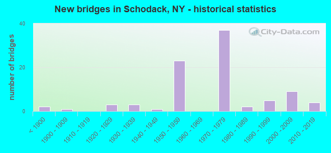
- New bridges - historical statistics
- 2Before 1900
- 11900-1909
- 31920-1929
- 31930-1939
- 11940-1949
- 231950-1959
- 371970-1979
- 21980-1989
- 51990-1999
- 92000-2009
- 42010-2019

- Reconstructed bridges - Historical Statistics
- 41980-1989
- 31990-1999
- 42000-2009
- 22010-2019


- Bridge Condition - Deck
- 3.8%Excellent
- 26.4%Very good
- 17.0%Good
- 24.5%Satisfactory
- 24.5%Fair
- 3.8%Poor

- Bridge Condition - Superstructure
- 15.1%Excellent
- 9.4%Very good
- 32.1%Good
- 30.2%Satisfactory
- 9.4%Fair
- 1.9%Poor
- 1.9%Serious

- Bridge Condition - Substructure
- 11.3%Excellent
- 13.2%Very good
- 18.9%Good
- 32.1%Satisfactory
- 22.6%Fair
- 1.9%Poor

- Bridge Condition - Channel
- 8.0%Excellent
- 8.0%Very good
- 20.0%Good
- 32.0%Satisfactory
- 32.0%Fair

- Bridge Condition - Culverts
- 50.0%Good
- 33.3%Satisfactory
- 16.7%Fair
Find on map >> Show street view
Structure Number: 100549, Location: 0.1 MI N JCT RTS 150 & 9 (Lat: 42.555003, Lng: -73.676733), Route carried "on" structure: US 9, Year Built: 2016, Status: Open, Structure Length: 2.13m (6.99ft), Average Daily Traffic: 17,442 (year 2020), Truck Traffic: 8%, Average Future Daily Traffic: 17,523 (year 2040), Design Load: HL 93, Features Intersected: MOORDENER KILL
Minimum Vertical Clearance: 30+ m (98+ ft), Kilometerpoint: 9.590, Lanes on structure: 4, Base Highway Network: Yes, Owner: State Highway Agency, Approaching Roadway Width: 24.4m (80.1ft), Skew: 23 degrees, Material/Design: Steel, Design/Construction: Stringer/Multi-beam, Number Of Spans In Main Unit: 1, Length of Maximum Span: 20.7m (67.9ft), Curb-To-Curb Width: 20.7m (67.9ft), Out-to-Out Width: 21.7m (71.2ft)
Condition: Deck: Very good, Superstructure: Excellent, Substructure: Excellent, Channel: Very good, Operating Rating: 67.7 metric tons, Method Used To Determine Operating Rating: Load and Resistance Factor Rating (LRFR) rating reported by rating factor(RF) method using HL-93 loadings, Inventory Rating: 52.2 metric tons, Method Used To Determine Inventory Rating: Load and Resistance Factor Rating (LRFR) rating reported by rating factor(RF) method using HL-93 loadings, Structural Evaluation: Superior to present desirable criteria, Deck Geometry: Superior to present desirable criteria, Waterway Adequacy: Meets minimum limits, Approach Roadway Alignment: Equal to present desirable criteria, Length Of Structure Improvement: 2.13m (6.99ft), Designated Inspection Frequency: Every 24 months, Inspection Date: September 2020, Bridge Improvement Cost: $1,469,000, Roadway Improvement Cost: $860,000, Total Project Cost: $2,329,000 ( Estimate for 2021), Deck Structure Type: Concrete Cast-file-Place, Wearing Surface/Protective System: Wearing Surface: Integral Concrete, Deck Protection: Epoxy Coated Reinforcing
Find on map >> Show street view
Structure Number: 10055, Location: 0.2 MI N JCT RTS 150 & 9 (Lat: 42.555439, Lng: -73.677131), Route carried "on" structure: US 9, Year Built: 2016, Status: Open, Structure Length: 2.13m (6.99ft), Average Daily Traffic: 17,442 (year 2020), Truck Traffic: 8%, Average Future Daily Traffic: 17,523 (year 2040), Design Load: HL 93, Features Intersected: N BR MOORDENER KILL
Minimum Vertical Clearance: 30+ m (98+ ft), Kilometerpoint: 9.751, Lanes on structure: 4, Base Highway Network: Yes, Owner: State Highway Agency, Approaching Roadway Width: 20.7m (67.9ft), Skew: 20 degrees, Material/Design: Steel, Design/Construction: Stringer/Multi-beam, Number Of Spans In Main Unit: 1, Length of Maximum Span: 20.7m (67.9ft), Curb-To-Curb Width: 20.7m (67.9ft), Out-to-Out Width: 21.7m (71.2ft)
Condition: Deck: Very good, Superstructure: Excellent, Substructure: Excellent, Channel: Excellent, Operating Rating: 65.4 metric tons, Method Used To Determine Operating Rating: Load and Resistance Factor Rating (LRFR) rating reported by rating factor(RF) method using HL-93 loadings, Inventory Rating: 50.5 metric tons, Method Used To Determine Inventory Rating: Load and Resistance Factor Rating (LRFR) rating reported by rating factor(RF) method using HL-93 loadings, Structural Evaluation: Superior to present desirable criteria, Deck Geometry: Superior to present desirable criteria, Waterway Adequacy: Meets minimum limits, Approach Roadway Alignment: Equal to present desirable criteria, Length Of Structure Improvement: 2.13m (6.99ft), Designated Inspection Frequency: Every 24 months, Inspection Date: September 2020, Bridge Improvement Cost: $1,138,000, Roadway Improvement Cost: $666,000, Total Project Cost: $1,804,000 ( Estimate for 2021), Deck Structure Type: Concrete Cast-file-Place, Wearing Surface/Protective System: Wearing Surface: Integral Concrete, Deck Protection: Epoxy Coated Reinforcing
Find on map >> Show street view
Structure Number: 10066, Location: JCT RT 9J & MUITZES KILL (Lat: 42.517542, Lng: -73.760319), Route carried "on" structure: State highway 9J, Year Built: 1973, Status: Open, Structure Length: 1.46m (4.79ft), Average Daily Traffic: 1,152 (year 2016), Truck Traffic: 4%, Average Future Daily Traffic: 1,201 (year 2040), Features Intersected: MUITZES KILL
Minimum Vertical Clearance: 30+ m (98+ ft), Kilometerpoint: 5.937, Lanes on structure: 2, Base Highway Network: Yes, Owner: State Highway Agency, Approaching Roadway Width: 10.4m (34.1ft), Material/Design: Steel, Design/Construction: Culvert, Number Of Spans In Main Unit: 3, Length of Maximum Span: 4.2m (13.8ft)
Condition: Channel: Fair, Culverts: Good, Operating Rating: 75.6 metric tons, Method Used To Determine Operating Rating: Field evaluation and documented engineering judgment, Inventory Rating: 32.7 metric tons, Method Used To Determine Inventory Rating: Field evaluation and documented engineering judgment, Structural Evaluation: Better than present minimum criteria, Waterway Adequacy: Meets minimum limits, Approach Roadway Alignment: Equal to present desirable criteria, Length Of Structure Improvement: 1.46m (4.79ft), Designated Inspection Frequency: Every 24 months, Inspection Date: July 2021, Bridge Improvement Cost: $267,000, Roadway Improvement Cost: $156,000, Total Project Cost: $424,000 ( Estimate for 2021)
Find on map >> Show street view
Structure Number: 100661, Location: JCT RT 9J & VLOCKIE KILL (Lat: 42.525750, Lng: -73.757697), Route carried "on" structure: State highway 9J, Year Built: 1930, Status: Open, Structure Length: 0.85m (2.79ft), Average Daily Traffic: 1,152 (year 2016), Truck Traffic: 4%, Average Future Daily Traffic: 1,201 (year 2040), Features Intersected: VLOCKIE KILL
Minimum Vertical Clearance: 30+ m (98+ ft), Kilometerpoint: 6.822, Lanes on structure: 2, Base Highway Network: Yes, Owner: State Highway Agency, Approaching Roadway Width: 7.9m (25.9ft), Skew: 3 degrees, Material/Design: Concrete, Design/Construction: Slab, Number Of Spans In Main Unit: 1, Length of Maximum Span: 7.9m (25.9ft), Curb or Sidewalk Widths: Left: 0.0m, Right: 1.3m (4.3ft), Curb-To-Curb Width: 8.0m (26.2ft), Out-to-Out Width: 10.4m (34.1ft)
Condition: Deck: Fair, Superstructure: Fair, Substructure: Fair, Channel: Satisfactory, Inventory Rating: 64.4 metric tons, Method Used To Determine Inventory Rating: Load Factor (LF), Structural Evaluation: Somewhat better than minimum adequacy, Deck Geometry: Meets minimum limits, Waterway Adequacy: Meets minimum limits, Approach Roadway Alignment: Equal to present desirable criteria, Length Of Structure Improvement: 0.85m (2.79ft), Designated Inspection Frequency: Every 24 months, Inspection Date: June 2021, Bridge Improvement Cost: $536,000, Roadway Improvement Cost: $314,000, Total Project Cost: $850,000 ( Estimate for 2021), Wearing Surface/Protective System: Wearing Surface: Bituminous
Find on map >> Show street view
Structure Number: 100662, Location: 0.9 MI N JCT RTS 150 & 9J (Lat: 42.543453, Lng: -73.749097), Route carried "on" structure: State highway 9J, Year Built: 1970, Status: Open, Structure Length: 3.38m (11.09ft), Average Daily Traffic: 2,859 (year 2020), Truck Traffic: 5%, Average Future Daily Traffic: 3,537 (year 2040), Design Load: HS 20, Features Intersected: MOORDENER KILL
Minimum Vertical Clearance: 30+ m (98+ ft), Kilometerpoint: 9.043, Lanes on structure: 2, Base Highway Network: Yes, Owner: State Highway Agency, Approaching Roadway Width: 14.6m (47.9ft), Skew: 3 degrees, Material/Design: Steel, Design/Construction: Stringer/Multi-beam, Number Of Spans In Main Unit: 1, Length of Maximum Span: 32.3m (106.0ft), Curb-To-Curb Width: 14.4m (47.2ft), Out-to-Out Width: 15.2m (49.9ft)
Condition: Deck: Poor, Superstructure: Good, Substructure: Satisfactory, Channel: Fair, Operating Rating: 75.8 metric tons, Method Used To Determine Operating Rating: Load and Resistance Factor Rating (LRFR) rating reported by rating factor(RF) method using HL-93 loadings, Inventory Rating: 58.3 metric tons, Method Used To Determine Inventory Rating: Load and Resistance Factor Rating (LRFR) rating reported by rating factor(RF) method using HL-93 loadings, Structural Evaluation: Equal to present minimum criteria, Deck Geometry: Superior to present desirable criteria, Waterway Adequacy: Somewhat better than minimum adequacy, Approach Roadway Alignment: Equal to present desirable criteria, Length Of Structure Improvement: 3.38m (11.09ft), Designated Inspection Frequency: Every 24 months, Inspection Date: April 2021, Bridge Improvement Cost: $1,393,000, Roadway Improvement Cost: $816,000, Total Project Cost: $2,209,000 ( Estimate for 2021), Deck Structure Type: Concrete Cast-file-Place, Wearing Surface/Protective System: Wearing Surface: Integral Concrete
Find on map >> Show street view
Structure Number: 101599, Location: 0.4 MI W JCT RTS 20 & 203 (Lat: 42.517175, Lng: -73.615633), Route carried "on" structure: US 20, Year Built: 2000, Status: Open, Structure Length: 2.07m (6.79ft), Average Daily Traffic: 7,276 (year 2019), Truck Traffic: 7%, Average Future Daily Traffic: 8,152 (year 2040), Design Load: HS 25 or greater, Features Intersected: VALATIEKILL CREEK
Minimum Vertical Clearance: 30+ m (98+ ft), Kilometerpoint: 18.906, Lanes on structure: 2, Base Highway Network: Yes, Owner: State Highway Agency, Approaching Roadway Width: 10.7m (35.1ft), Material/Design: Prestressed concrete, Design/Construction: Box Beam or Girders - Multiple, Number Of Spans In Main Unit: 1, Length of Maximum Span: 19.8m (65.0ft), Curb or Sidewalk Widths: Left: 3.4m (11.2ft), Right: 1.5m (4.9ft), Curb-To-Curb Width: 10.8m (35.4ft), Out-to-Out Width: 16.3m (53.5ft)
Condition: Deck: Good, Superstructure: Fair, Substructure: Excellent, Channel: Good, Operating Rating: 84.4 metric tons, Method Used To Determine Operating Rating: Load Factor (LF), Inventory Rating: 50.8 metric tons, Method Used To Determine Inventory Rating: Load Factor (LF), Structural Evaluation: Somewhat better than minimum adequacy, Deck Geometry: Meets minimum limits, Waterway Adequacy: Somewhat better than minimum adequacy, Approach Roadway Alignment: Equal to present desirable criteria, Length Of Structure Improvement: 2.07m (6.79ft), Designated Inspection Frequency: Every 24 months, Inspection Date: May 2020, Bridge Improvement Cost: $1,162,000, Roadway Improvement Cost: $680,000, Total Project Cost: $1,842,000 ( Estimate for 2021), Deck Structure Type: Concrete Cast-file-Place, Wearing Surface/Protective System: Wearing Surface: Monolithic Concrete, Deck Protection: Epoxy Coated Reinforcing
Find on map >> Show street view
Structure Number: 103853, Location: 3.8 MI W JCT RT I90 & 150 (Lat: 42.534406, Lng: -73.734347), Route carried "on" structure: State highway 150, Year Built: 2000, Status: Open, Structure Length: 2.44m (8.01ft), Average Daily Traffic: 2,130 (year 2019), Truck Traffic: 3%, Average Future Daily Traffic: 2,635 (year 2040), Design Load: HS 25 or greater, Features Intersected: MOORDENER KILL
Minimum Vertical Clearance: 30+ m (98+ ft), Kilometerpoint: 2.011, Lanes on structure: 2, Base Highway Network: Yes, Owner: State Highway Agency, Approaching Roadway Width: 8.5m (27.9ft), Skew: 4 degrees, Material/Design: Prestressed concrete, Design/Construction: Stringer/Multi-beam, Number Of Spans In Main Unit: 1, Length of Maximum Span: 23.1m (75.8ft), Curb-To-Curb Width: 8.4m (27.6ft), Out-to-Out Width: 9.4m (30.8ft)
Condition: Deck: Very good, Superstructure: Excellent, Substructure: Good, Channel: Good, Operating Rating: 89.8 metric tons, Method Used To Determine Operating Rating: Load Factor (LF), Inventory Rating: 49.0 metric tons, Method Used To Determine Inventory Rating: Load Factor (LF), Structural Evaluation: Better than present minimum criteria, Deck Geometry: High priority of corrective action, Waterway Adequacy: Equal to present minimum criteria, Approach Roadway Alignment: Equal to present desirable criteria, Length Of Structure Improvement: 2.43m (7.97ft), Designated Inspection Frequency: Every 24 months, Inspection Date: May 2020, Bridge Improvement Cost: $985,000, Roadway Improvement Cost: $577,000, Total Project Cost: $1,561,000 ( Estimate for 2021), Deck Structure Type: Concrete Cast-file-Place, Wearing Surface/Protective System: Wearing Surface: Monolithic Concrete, Deck Protection: Epoxy Coated Reinforcing
Find on map >> Show street view
Structure Number: 103854, Location: 2.9 MI W JCT I90 & SH 150 (Lat: 42.541169, Lng: -73.719922), Route carried "on" structure: State highway 150, Year Built: 1899, Year Reconstructed: 1990, Status: Open, Structure Length: 3.05m (10.01ft), Average Daily Traffic: 2,130 (year 2019), Truck Traffic: 3%, Average Future Daily Traffic: 2,635 (year 2040), Design Load: HS 20, Features Intersected: BROOKVIEW STA RD, AMTRAK
Minimum Vertical Clearance: 30+ m (98+ ft), Kilometerpoint: 3.508, Lanes on structure: 2, Lanes under structure: 2, Base Highway Network: Yes, Owner: State Highway Agency, Approaching Roadway Width: 9.1m (29.9ft), Skew: 1 degrees, Material/Design: Prestressed concrete, Design/Construction: Box Beam or Girders - Multiple, Number Of Spans In Main Unit: 1, Length of Maximum Span: 29.6m (97.1ft), Curb-To-Curb Width: 9.1m (29.9ft), Out-to-Out Width: 10.1m (33.1ft)
Condition: Deck: Satisfactory, Superstructure: Good, Substructure: Good, Operating Rating: 87.1 metric tons, Method Used To Determine Operating Rating: Load Factor (LF), Inventory Rating: 36.3 metric tons, Method Used To Determine Inventory Rating: Load Factor (LF), Structural Evaluation: Better than present minimum criteria, Deck Geometry: Meets minimum limits, Underclear: High priority of corrective action, Approach Roadway Alignment: Equal to present desirable criteria, Length Of Structure Improvement: 3.04m (9.97ft), Designated Inspection Frequency: Every 24 months, Inspection Date: September 2021, Bridge Improvement Cost: $1,325,000, Roadway Improvement Cost: $776,000, Total Project Cost: $2,101,000 ( Estimate for 2021), Deck Structure Type: Concrete Cast-file-Place, Wearing Surface/Protective System: Wearing Surface: Integral Concrete
Find on map >> Show street view
Structure Number: 103855, Location: 0.1 MI E JCT RT I90 & 150 (Lat: 42.551161, Lng: -73.683203), Route carried "on" structure: State highway 150, Year Built: 1973, Status: Open, Structure Length: 2.01m (6.59ft), Average Daily Traffic: 642 (year 2016), Truck Traffic: 4%, Average Future Daily Traffic: 794 (year 2040), Features Intersected: MOORDENER KILL
Minimum Vertical Clearance: 30+ m (98+ ft), Kilometerpoint: 7.241, Lanes on structure: 2, Base Highway Network: Yes, Owner: State Highway Agency, Approaching Roadway Width: 13.4m (44.0ft), Skew: 2 degrees, Material/Design: Prestressed concrete, Design/Construction: Box Beam or Girders - Multiple, Number Of Spans In Main Unit: 1, Length of Maximum Span: 17.9m (58.7ft), Curb-To-Curb Width: 13.4m (44.0ft), Out-to-Out Width: 14.1m (46.3ft)
Condition: Deck: Fair, Superstructure: Satisfactory, Substructure: Fair, Channel: Satisfactory, Operating Rating: 64.4 metric tons, Method Used To Determine Operating Rating: Load Factor (LF), Inventory Rating: 38.1 metric tons, Method Used To Determine Inventory Rating: Load Factor (LF), Structural Evaluation: Somewhat better than minimum adequacy, Deck Geometry: Superior to present desirable criteria, Waterway Adequacy: Meets minimum limits, Approach Roadway Alignment: Equal to present desirable criteria, Length Of Structure Improvement: 2.01m (6.59ft), Designated Inspection Frequency: Every 24 months, Inspection Date: April 2021, Bridge Improvement Cost: $1,341,000, Roadway Improvement Cost: $785,000, Total Project Cost: $2,126,000 ( Estimate for 2021), Deck Structure Type: Concrete Cast-file-Place, Wearing Surface/Protective System: Wearing Surface: Monolithic Concrete, Deck Protection: Epoxy Coated Reinforcing
Find on map >> Show street view
Structure Number: 103856, Location: 1 MILE E JCT I90 & SH 150 (Lat: 42.557669, Lng: -73.658050), Route carried "on" structure: State highway 150, Year Built: 2005, Status: Open, Structure Length: 1.37m (4.49ft), Average Daily Traffic: 3,392 (year 2020), Truck Traffic: 9%, Average Future Daily Traffic: 4,120 (year 2040), Design Load: HS 25 or greater, Features Intersected: MOORDENER KILL
Minimum Vertical Clearance: 30+ m (98+ ft), Kilometerpoint: 9.509, Lanes on structure: 2, Base Highway Network: Yes, Owner: State Highway Agency, Approaching Roadway Width: 9.4m (30.8ft), Skew: 4 degrees, Material/Design: Concrete, Design/Construction: Frame, Number Of Spans In Main Unit: 1, Length of Maximum Span: 12.2m (40.0ft), Curb-To-Curb Width: 9.4m (30.8ft), Out-to-Out Width: 10.4m (34.1ft)
Condition: Deck: Good, Superstructure: Good, Substructure: Very good, Channel: Satisfactory, Operating Rating: 69.0 metric tons, Method Used To Determine Operating Rating: Load Factor (LF), Inventory Rating: 41.0 metric tons, Method Used To Determine Inventory Rating: Load Factor (LF), Structural Evaluation: Better than present minimum criteria, Deck Geometry: Meets minimum limits, Waterway Adequacy: Equal to present minimum criteria, Approach Roadway Alignment: Equal to present desirable criteria, Length Of Structure Improvement: 1.37m (4.49ft), Designated Inspection Frequency: Every 24 months, Inspection Date: August 2021, Bridge Improvement Cost: $551,000, Roadway Improvement Cost: $323,000, Total Project Cost: $874,000 ( Estimate for 2021), Wearing Surface/Protective System: Wearing Surface: Bituminous
Find on map >> Show street view
Structure Number: 109268, Location: 1.8 MI N JCT I90 & US 9 (Lat: 42.584908, Lng: -73.677322), Route carried "on" structure: Interstate 90, Year Built: 1971, Status: Open, Structure Length: 1.04m (3.41ft), Average Daily Traffic: 33,203 (year 2020), Truck Traffic: 12%, Average Future Daily Traffic: 52,616 (year 2040), Design Load: H 20, Features Intersected: N B MOORDENER KLL
Minimum Vertical Clearance: 30+ m (98+ ft), Kilometerpoint: 10.121, Lanes on structure: 6, Base Highway Network: Yes, Owner: State Highway Agency, Approaching Roadway Width: 39.9m (130.9ft), Skew: 21 degrees, Material/Design: Concrete, Design/Construction: Culvert, Number Of Spans In Main Unit: 2, Length of Maximum Span: 4.8m (15.7ft)
Condition: Channel: Fair, Culverts: Satisfactory, Structural Evaluation: Equal to present minimum criteria, Waterway Adequacy: High priority of corrective action, Approach Roadway Alignment: Equal to present desirable criteria, Length Of Structure Improvement: 1.03m (3.38ft), Designated Inspection Frequency: Every 24 months, Inspection Date: May 2021, Bridge Improvement Cost: $1,606,000, Roadway Improvement Cost: $940,000, Total Project Cost: $2,546,000 ( Estimate for 2021)
Find on map >> Show street view
Structure Number: 1092691, Location: 1.4 MI N JCT RTS I90 & 9 (Lat: 42.579700, Lng: -73.678900), Route carried "on" structure: Interstate 90, Year Built: 1972, Status: Open, Structure Length: 3.32m (10.89ft), Average Daily Traffic: 27,810 (year 2006), Truck Traffic: 9%, Design Load: HS 20, Features Intersected: RTE 912F
Minimum Vertical Clearance: 30+ m (98+ ft), Kilometerpoint: 21.078, Lanes on structure: 3, Lanes under structure: 2, Base Highway Network: Yes, Owner: State Highway Agency, Approaching Roadway Width: 15.8m (51.8ft), Skew: 1 degrees, Material/Design: Steel, Design/Construction: Stringer/Multi-beam, Number Of Spans In Main Unit: 1, Length of Maximum Span: 32.0m (105.0ft), Curb-To-Curb Width: 16.3m (53.5ft), Out-to-Out Width: 17.3m (56.8ft)
Condition: Deck: Good, Superstructure: Satisfactory, Substructure: Good, Operating Rating: 79.1 metric tons, Method Used To Determine Operating Rating: Load and Resistance Factor Rating (LRFR) rating reported by rating factor(RF) method using HL-93 loadings, Inventory Rating: 60.9 metric tons, Method Used To Determine Inventory Rating: Load and Resistance Factor Rating (LRFR) rating reported by rating factor(RF) method using HL-93 loadings, Structural Evaluation: Equal to present minimum criteria, Deck Geometry: Equal to present minimum criteria, Underclear: Equal to present minimum criteria, Approach Roadway Alignment: Equal to present desirable criteria, Length Of Structure Improvement: 3.32m (10.89ft), Designated Inspection Frequency: Every 24 months, Inspection Date: May 2020, Bridge Improvement Cost: $1,980,000, Roadway Improvement Cost: $1,159,000, Total Project Cost: $3,139,000 ( Estimate for 2021), Deck Structure Type: Concrete Cast-file-Place, Wearing Surface/Protective System: Wearing Surface: Monolithic Concrete
Find on map >> Show street view
Structure Number: 1092692, Location: 1.4 MI N JCT RTS I90 & 9 (Lat: 42.579642, Lng: -73.679253), Route carried "on" structure: Interstate 90, Year Built: 1972, Status: Open, Structure Length: 3.32m (10.89ft), Average Daily Traffic: 16,602 (year 2020), Truck Traffic: 13%, Average Future Daily Traffic: 26,308 (year 2040), Design Load: HS 20, Features Intersected: Schodack Pedestrian Path
Minimum Vertical Clearance: 30+ m (98+ ft), Kilometerpoint: 10.716, Lanes on structure: 3, Lanes under structure: 2, Base Highway Network: Yes, Owner: State Highway Agency, Approaching Roadway Width: 16.5m (54.1ft), Skew: 1 degrees, Material/Design: Steel, Design/Construction: Stringer/Multi-beam, Number Of Spans In Main Unit: 1, Length of Maximum Span: 32.0m (105.0ft), Curb-To-Curb Width: 16.3m (53.5ft), Out-to-Out Width: 17.3m (56.8ft)
Condition: Deck: Good, Superstructure: Satisfactory, Substructure: Satisfactory, Operating Rating: 85.5 metric tons, Method Used To Determine Operating Rating: Load and Resistance Factor Rating (LRFR) rating reported by rating factor(RF) method using HL-93 loadings, Inventory Rating: 65.8 metric tons, Method Used To Determine Inventory Rating: Load and Resistance Factor Rating (LRFR) rating reported by rating factor(RF) method using HL-93 loadings, Structural Evaluation: Equal to present minimum criteria, Deck Geometry: Equal to present minimum criteria, Underclear: Equal to present minimum criteria, Approach Roadway Alignment: Equal to present desirable criteria, Length Of Structure Improvement: 3.32m (10.89ft), Designated Inspection Frequency: Every 24 months, Inspection Date: April 2021, Bridge Improvement Cost: $1,918,000, Roadway Improvement Cost: $1,123,000, Total Project Cost: $3,041,000 ( Estimate for 2021), Deck Structure Type: Concrete Cast-file-Place, Wearing Surface/Protective System: Wearing Surface: Monolithic Concrete
Find on map >> Show street view
Structure Number: 10927, Location: AT SCHODACK CENTER (Lat: 42.578650, Lng: -73.685506), Route carried "on" structure: State highway 912F, Year Built: 1972, Status: Open, Structure Length: 1.25m (4.10ft), Average Daily Traffic: 5,819 (year 2020), Truck Traffic: 4%, Average Future Daily Traffic: 7,068 (year 2040), Design Load: HS 20, Features Intersected: N B MOORDENERKILL
Minimum Vertical Clearance: 30+ m (98+ ft), Kilometerpoint: 0.402, Lanes on structure: 2, Base Highway Network: Yes, Owner: State Highway Agency, Approaching Roadway Width: 12.5m (41.0ft), Skew: 3 degrees, Material/Design: Concrete continuous, Design/Construction: Culvert, Number Of Spans In Main Unit: 2, Length of Maximum Span: 4.8m (15.7ft), Curb or Sidewalk Widths: Left: 5.2m (17.1ft), Right: 0.0m
Condition: Channel: Fair, Culverts: Good, Inventory Rating: 72.6 metric tons, Method Used To Determine Inventory Rating: Load Factor (LF), Structural Evaluation: Better than present minimum criteria, Waterway Adequacy: Somewhat better than minimum adequacy, Approach Roadway Alignment: Better than present minimum criteria, Length Of Structure Improvement: 1.24m (4.07ft), Designated Inspection Frequency: Every 24 months, Inspection Date: June 2021, Bridge Improvement Cost: $508,000, Roadway Improvement Cost: $297,000, Total Project Cost: $805,000 ( Estimate for 2021)
Find on map >> Show street view
Structure Number: 1092719, Location: .9 MI N JCT I90 & US9 (Lat: 42.571228, Lng: -73.679072), Route carried "on" structure: Interstate 90, Year Built: 1972, Status: Open, Structure Length: 1.04m (3.41ft), Average Daily Traffic: 29,503 (year 2020), Truck Traffic: 13%, Average Future Daily Traffic: 46,753 (year 2040), Design Load: H 20, Features Intersected: N BRANCH MOORDENER KILL
Minimum Vertical Clearance: 30+ m (98+ ft), Kilometerpoint: 11.665, Lanes on structure: 6, Base Highway Network: Yes, Owner: State Highway Agency, Approaching Roadway Width: 33.2m (108.9ft), Skew: 21 degrees, Material/Design: Concrete, Design/Construction: Culvert, Number Of Spans In Main Unit: 2, Length of Maximum Span: 4.8m (15.7ft)
Condition: Channel: Fair, Culverts: Satisfactory, Structural Evaluation: Equal to present minimum criteria, Waterway Adequacy: Superior to present desirable criteria, Approach Roadway Alignment: Equal to present desirable criteria, Length Of Structure Improvement: 1.03m (3.38ft), Designated Inspection Frequency: Every 24 months, Inspection Date: June 2021, Bridge Improvement Cost: $1,211,000, Roadway Improvement Cost: $709,000, Total Project Cost: $1,920,000 ( Estimate for 2021)
Find on map >> Show street view
Structure Number: 1092721, Location: 0.7 MI N JCT RTS I90 & 9 (Lat: 42.568772, Lng: -73.678650), Route carried "on" structure: Interstate 90, Year Built: 1972, Year Reconstructed: 2012, Status: Open, Structure Length: 2.99m (9.81ft), Average Daily Traffic: 16,406 (year 2005), Truck Traffic: 9%, Design Load: HS 20, Features Intersected: KRAFT ROAD
Minimum Vertical Clearance: 30+ m (98+ ft), Kilometerpoint: 11.923, Lanes on structure: 3, Lanes under structure: 2, Base Highway Network: Yes, Owner: State Highway Agency, Approaching Roadway Width: 16.5m (54.1ft), Skew: 2 degrees, Material/Design: Steel, Design/Construction: Stringer/Multi-beam, Number Of Spans In Main Unit: 1, Length of Maximum Span: 28.3m (92.8ft), Curb-To-Curb Width: 16.3m (53.5ft), Out-to-Out Width: 17.1m (56.1ft)
Condition: Deck: Good, Superstructure: Good, Substructure: Fair, Operating Rating: 77.1 metric tons, Method Used To Determine Operating Rating: Load Factor (LF), Inventory Rating: 45.4 metric tons, Method Used To Determine Inventory Rating: Load Factor (LF), Structural Evaluation: Somewhat better than minimum adequacy, Deck Geometry: Equal to present minimum criteria, Underclear: Better than present minimum criteria, Approach Roadway Alignment: Equal to present desirable criteria, Length Of Structure Improvement: 2.98m (9.78ft), Designated Inspection Frequency: Every 24 months, Inspection Date: October 2020, Bridge Improvement Cost: $1,697,000, Roadway Improvement Cost: $993,000, Total Project Cost: $2,690,000 ( Estimate for 2021), Deck Structure Type: Concrete Cast-file-Place, Wearing Surface/Protective System: Wearing Surface: Integral Concrete, Deck Protection: Epoxy Coated Reinforcing
Find on map >> Show street view
Structure Number: 1092722, Location: 0.7 MI N JCT RTS I90 & 9 (Lat: 42.568692, Lng: -73.679008), Route carried "on" structure: Interstate 90, Year Built: 1972, Year Reconstructed: 2012, Status: Open, Structure Length: 2.99m (9.81ft), Average Daily Traffic: 14,752 (year 2020), Truck Traffic: 13%, Average Future Daily Traffic: 23,376 (year 2040), Design Load: HS 20, Features Intersected: KRAFT ROAD
Minimum Vertical Clearance: 30+ m (98+ ft), Kilometerpoint: 11.939, Lanes on structure: 3, Lanes under structure: 2, Base Highway Network: Yes, Owner: State Highway Agency, Approaching Roadway Width: 16.5m (54.1ft), Skew: 2 degrees, Material/Design: Steel, Design/Construction: Stringer/Multi-beam, Number Of Spans In Main Unit: 1, Length of Maximum Span: 28.3m (92.8ft), Curb-To-Curb Width: 16.3m (53.5ft), Out-to-Out Width: 17.1m (56.1ft)
Condition: Deck: Good, Superstructure: Fair, Substructure: Fair, Operating Rating: 77.1 metric tons, Method Used To Determine Operating Rating: Load Factor (LF), Inventory Rating: 45.4 metric tons, Method Used To Determine Inventory Rating: Load Factor (LF), Structural Evaluation: Somewhat better than minimum adequacy, Deck Geometry: Equal to present minimum criteria, Underclear: Equal to present minimum criteria, Approach Roadway Alignment: Equal to present desirable criteria, Length Of Structure Improvement: 2.98m (9.78ft), Designated Inspection Frequency: Every 24 months, Inspection Date: October 2020, Bridge Improvement Cost: $1,718,000, Roadway Improvement Cost: $1,006,000, Total Project Cost: $2,723,000 ( Estimate for 2021), Deck Structure Type: Concrete Cast-file-Place, Wearing Surface/Protective System: Wearing Surface: Integral Concrete, Deck Protection: Epoxy Coated Reinforcing
Find on map >> Show street view
Structure Number: 109273, Location: JCT RTS 9 & I90 (Lat: 42.558819, Lng: -73.679397), Route carried "on" structure: US 9, Year Built: 1973, Status: Open, Structure Length: 9.39m (30.81ft), Average Daily Traffic: 17,442 (year 2020), Truck Traffic: 8%, Average Future Daily Traffic: 17,523 (year 2040), Design Load: HS 20, Features Intersected: 90I 90I 1402 2074 WB, RT
Minimum Vertical Clearance: 30+ m (98+ ft), Kilometerpoint: 10.185, Lanes on structure: 5, Lanes under structure: 6, Base Highway Network: Yes, Owner: State Highway Agency, Approaching Roadway Width: 29.9m (98.1ft), Skew: 24 degrees, Material/Design: Steel, Design/Construction: Stringer/Multi-beam, Number Of Spans In Main Unit: 2, Length of Maximum Span: 47.2m (154.9ft), Curb-To-Curb Width: 30.2m (99.1ft), Out-to-Out Width: 31.1m (102.0ft)
Condition: Deck: Fair, Superstructure: Satisfactory, Substructure: Fair, Operating Rating: 88.0 metric tons, Method Used To Determine Operating Rating: Load Factor (LF), Inventory Rating: 52.6 metric tons, Method Used To Determine Inventory Rating: Load Factor (LF), Structural Evaluation: Somewhat better than minimum adequacy, Deck Geometry: Superior to present desirable criteria, Underclear: Meets minimum limits, Approach Roadway Alignment: Equal to present desirable criteria, Length Of Structure Improvement: 9.38m (30.77ft), Designated Inspection Frequency: Every 24 months, Inspection Date: November 2020, Bridge Improvement Cost: $8,026,000, Roadway Improvement Cost: $4,700,000, Total Project Cost: $12,726,000 ( Estimate for 2021), Deck Structure Type: Concrete Cast-file-Place, Wearing Surface/Protective System: Wearing Surface: Monolithic Concrete
Find on map >> Show street view
Structure Number: 1092751, Location: JCT OF RTS I90 & 150 (Lat: 42.550658, Lng: -73.684294), Route carried "on" structure: Interstate 90, Year Built: 1972, Status: Open, Structure Length: 3.60m (11.81ft), Average Daily Traffic: 10,583 (year 2007), Truck Traffic: 9%, Design Load: HS 20, Features Intersected: RTE 150
Minimum Vertical Clearance: 30+ m (98+ ft), Kilometerpoint: 24.457, Lanes on structure: 2, Lanes under structure: 2, Base Highway Network: Yes, Owner: State Highway Agency, Approaching Roadway Width: 12.8m (42.0ft), Skew: 4 degrees, Material/Design: Steel, Design/Construction: Stringer/Multi-beam, Number Of Spans In Main Unit: 1, Length of Maximum Span: 34.7m (113.8ft), Curb-To-Curb Width: 12.5m (41.0ft), Out-to-Out Width: 13.4m (44.0ft)
Condition: Deck: Satisfactory, Superstructure: Poor, Substructure: Poor, Operating Rating: 89.8 metric tons, Method Used To Determine Operating Rating: Load Factor (LF), Inventory Rating: 53.5 metric tons, Method Used To Determine Inventory Rating: Load Factor (LF), Structural Evaluation: Meets minimum limits, Deck Geometry: Better than present minimum criteria, Underclear: Equal to present minimum criteria, Approach Roadway Alignment: Equal to present desirable criteria, Length Of Structure Improvement: 3.59m (11.78ft), Designated Inspection Frequency: Every 24 months, Inspection Date: June 2021, Bridge Improvement Cost: $1,674,000, Roadway Improvement Cost: $980,000, Total Project Cost: $2,655,000 ( Estimate for 2021), Deck Structure Type: Concrete Cast-file-Place, Wearing Surface/Protective System: Wearing Surface: Monolithic Concrete
Find on map >> Show street view
Structure Number: 1092752, Location: JCT OF RTS I90 & 150 (Lat: 42.550464, Lng: -73.684792), Route carried "on" structure: Interstate 90, Year Built: 1972, Status: Open, Structure Length: 3.60m (11.81ft), Average Daily Traffic: 8,625 (year 2007), Truck Traffic: 18%, Average Future Daily Traffic: 13,668 (year 2040), Design Load: HS 20, Features Intersected: RTE 150
Minimum Vertical Clearance: 30+ m (98+ ft), Kilometerpoint: 14.079, Lanes on structure: 3, Lanes under structure: 2, Base Highway Network: Yes, Owner: State Highway Agency, Approaching Roadway Width: 16.5m (54.1ft), Skew: 4 degrees, Material/Design: Steel, Design/Construction: Stringer/Multi-beam, Number Of Spans In Main Unit: 1, Length of Maximum Span: 34.7m (113.8ft), Curb-To-Curb Width: 16.2m (53.1ft), Out-to-Out Width: 17.1m (56.1ft)
Condition: Deck: Fair, Superstructure: Good, Substructure: Fair, Operating Rating: 72.6 metric tons, Method Used To Determine Operating Rating: Load and Resistance Factor Rating (LRFR) rating reported by rating factor(RF) method using HL-93 loadings, Inventory Rating: 56.1 metric tons, Method Used To Determine Inventory Rating: Load and Resistance Factor Rating (LRFR) rating reported by rating factor(RF) method using HL-93 loadings, Structural Evaluation: Somewhat better than minimum adequacy, Deck Geometry: Equal to present minimum criteria, Underclear: Equal to present minimum criteria, Approach Roadway Alignment: Equal to present desirable criteria, Length Of Structure Improvement: 3.59m (11.78ft), Designated Inspection Frequency: Every 24 months, Inspection Date: June 2021, Bridge Improvement Cost: $2,209,000, Roadway Improvement Cost: $1,293,000, Total Project Cost: $3,502,000 ( Estimate for 2021), Deck Structure Type: Concrete Cast-file-Place, Wearing Surface/Protective System: Wearing Surface: Monolithic Concrete
Find on map >> Show street view
Structure Number: 1092761, Location: .1 MI S JCT I90 & SH 150 (Lat: 42.549022, Lng: -73.684639), Route carried "on" structure: Interstate 90, Year Built: 2014, Status: Open, Structure Length: 5.58m (18.31ft), Average Daily Traffic: 10,583 (year 2007), Truck Traffic: 9%, Design Load: HL 93, Features Intersected: MOORDENER KILL
Minimum Vertical Clearance: 30+ m (98+ ft), Kilometerpoint: 14.207, Lanes on structure: 2, Base Highway Network: Yes, Owner: State Highway Agency, Approaching Roadway Width: 12.8m (42.0ft), Material/Design: Steel, Design/Construction: Stringer/Multi-beam, Number Of Spans In Main Unit: 1, Length of Maximum Span: 55.2m (181.1ft), Curb-To-Curb Width: 12.8m (42.0ft), Out-to-Out Width: 13.7m (44.9ft)
Condition: Deck: Satisfactory, Superstructure: Excellent, Substructure: Excellent, Channel: Very good, Operating Rating: 91.6 metric tons, Method Used To Determine Operating Rating: Load Factor (LF), Inventory Rating: 54.4 metric tons, Method Used To Determine Inventory Rating: Load Factor (LF), Structural Evaluation: Superior to present desirable criteria, Deck Geometry: Equal to present desirable criteria, Waterway Adequacy: Superior to present desirable criteria, Approach Roadway Alignment: Equal to present desirable criteria, Length Of Structure Improvement: 5.57m (18.27ft), Designated Inspection Frequency: Every 24 months, Inspection Date: October 2021, Bridge Improvement Cost: $1,652,000, Roadway Improvement Cost: $967,000, Total Project Cost: $2,619,000 ( Estimate for 2021), Deck Structure Type: Concrete Cast-file-Place, Wearing Surface/Protective System: Wearing Surface: Integral Concrete, Deck Protection: Epoxy Coated Reinforcing
Find on map >> Show street view
Structure Number: 1092762, Location: .1 MI S JCT I90 & SH 150 (Lat: 42.549106, Lng: -73.685061), Route carried "on" structure: Interstate 90, Year Built: 2013, Status: Open, Structure Length: 5.58m (18.31ft), Average Daily Traffic: 8,625 (year 2007), Truck Traffic: 18%, Average Future Daily Traffic: 13,668 (year 2040), Design Load: HL 93, Features Intersected: MOORDENER KILL
Minimum Vertical Clearance: 30+ m (98+ ft), Kilometerpoint: 14.240, Lanes on structure: 3, Base Highway Network: Yes, Owner: State Highway Agency, Approaching Roadway Width: 16.5m (54.1ft), Material/Design: Steel, Design/Construction: Stringer/Multi-beam, Number Of Spans In Main Unit: 1, Length of Maximum Span: 55.2m (181.1ft), Curb-To-Curb Width: 16.5m (54.1ft), Out-to-Out Width: 17.4m (57.1ft)
Condition: Deck: Very good, Superstructure: Excellent, Substructure: Good, Channel: Excellent, Operating Rating: 98.0 metric tons, Method Used To Determine Operating Rating: Load Factor (LF), Inventory Rating: 59.0 metric tons, Method Used To Determine Inventory Rating: Load Factor (LF), Structural Evaluation: Better than present minimum criteria, Deck Geometry: Equal to present minimum criteria, Waterway Adequacy: Superior to present desirable criteria, Approach Roadway Alignment: Equal to present desirable criteria, Length Of Structure Improvement: 5.57m (18.27ft), Designated Inspection Frequency: Every 24 months, Inspection Date: October 2021, Bridge Improvement Cost: $1,971,000, Roadway Improvement Cost: $1,154,000, Total Project Cost: $3,125,000 ( Estimate for 2021), Deck Structure Type: Concrete Cast-file-Place, Wearing Surface/Protective System: Wearing Surface: Integral Concrete, Deck Protection: Epoxy Coated Reinforcing
Find on map >> Show street view
Structure Number: 109277, Location: 1.7 MI S JCT RT I90 & 150 (Lat: 42.525747, Lng: -73.687789), Route carried "on" structure: County highway , Year Built: 1974, Status: Open, Structure Length: 6.10m (20.01ft), Average Daily Traffic: 1,658 (year 2019), Truck Traffic: 5%, Average Future Daily Traffic: 2,411 (year 2040), Design Load: HS 20, Features Intersected: 90I 90I 14022098 WB, RT, Facility Carried by Structure: MAPLE HILL ROAD
Minimum Vertical Clearance: 30+ m (98+ ft), Kilometerpoint: 4.570, Lanes on structure: 2, Lanes under structure: 4, Owner: State Highway Agency, Approaching Roadway Width: 13.1m (43.0ft), Material/Design: Steel, Design/Construction: Stringer/Multi-beam, Number Of Spans In Main Unit: 2, Length of Maximum Span: 29.5m (96.8ft), Curb-To-Curb Width: 13.2m (43.3ft), Out-to-Out Width: 14.1m (46.3ft)
Condition: Deck: Good, Superstructure: Satisfactory, Substructure: Fair, Operating Rating: 68.4 metric tons, Method Used To Determine Operating Rating: Load and Resistance Factor Rating (LRFR) rating reported by rating factor(RF) method using HL-93 loadings, Inventory Rating: 52.8 metric tons, Method Used To Determine Inventory Rating: Load and Resistance Factor Rating (LRFR) rating reported by rating factor(RF) method using HL-93 loadings, Structural Evaluation: Somewhat better than minimum adequacy, Deck Geometry: Better than present minimum criteria, Underclear: Meets minimum limits, Approach Roadway Alignment: Equal to present desirable criteria, Length Of Structure Improvement: 6.09m (19.98ft), Designated Inspection Frequency: Every 24 months, Inspection Date: April 2021, Bridge Improvement Cost: $2,365,000, Roadway Improvement Cost: $1,385,000, Total Project Cost: $3,751,000 ( Estimate for 2021), Deck Structure Type: Concrete Cast-file-Place, Wearing Surface/Protective System: Wearing Surface: Monolithic Concrete
Find on map >> Show street view
Structure Number: 109278, Location: .3 MI S JCT CR 6 & I90 (Lat: 42.523969, Lng: -73.688206), Route carried "on" structure: Interstate 90, Year Built: 1974, Status: Open, Structure Length: 0.76m (2.49ft), Average Daily Traffic: 17,250 (year 2007), Truck Traffic: 18%, Average Future Daily Traffic: 27,336 (year 2040), Design Load: HS 20, Features Intersected: VLOCKIE KILL
Minimum Vertical Clearance: 30+ m (98+ ft), Kilometerpoint: 17.055, Lanes on structure: 4, Base Highway Network: Yes, Owner: State Highway Agency, Approaching Roadway Width: 25.6m (84.0ft), Skew: 20 degrees, Material/Design: Concrete, Design/Construction: Culvert, Number Of Spans In Main Unit: 2, Length of Maximum Span: 3.6m (11.8ft)
Condition: Channel: Fair, Culverts: Good, Operating Rating: 97.2 metric tons, Method Used To Determine Operating Rating: Load and Resistance Factor Rating (LRFR) rating reported by rating factor(RF) method using HL-93 loadings, Inventory Rating: 84.9 metric tons, Method Used To Determine Inventory Rating: Load and Resistance Factor Rating (LRFR) rating reported by rating factor(RF) method using HL-93 loadings, Structural Evaluation: Better than present minimum criteria, Waterway Adequacy: High priority of replacement, Approach Roadway Alignment: Better than present minimum criteria, Length Of Structure Improvement: 0.76m (2.49ft), Designated Inspection Frequency: Every 24 months, Inspection Date: May 2021, Bridge Improvement Cost: $1,785,000, Roadway Improvement Cost: $1,045,000, Total Project Cost: $2,830,000 ( Estimate for 2021)
Find on map >> Show street view
Structure Number: 1092791, Location: 2.1 MI S JCT RT I90 & 150 (Lat: 42.519708, Lng: -73.688436), Route carried "on" structure: Interstate 90, Year Built: 1974, Status: Open, Structure Length: 2.83m (9.28ft), Average Daily Traffic: 10,583 (year 2007), Truck Traffic: 9%, Design Load: HS 20, Features Intersected: VAN HOESEN ROAD
Minimum Vertical Clearance: 30+ m (98+ ft), Kilometerpoint: 17.506, Lanes on structure: 2, Lanes under structure: 2, Base Highway Network: Yes, Owner: State Highway Agency, Approaching Roadway Width: 12.8m (42.0ft), Skew: 1 degrees, Material/Design: Steel, Design/Construction: Stringer/Multi-beam, Number Of Spans In Main Unit: 1, Length of Maximum Span: 27.1m (88.9ft), Curb-To-Curb Width: 12.5m (41.0ft), Out-to-Out Width: 13.4m (44.0ft)
Condition: Deck: Fair, Superstructure: Satisfactory, Substructure: Satisfactory, Operating Rating: 91.6 metric tons, Method Used To Determine Operating Rating: Load Factor (LF), Inventory Rating: 54.4 metric tons, Method Used To Determine Inventory Rating: Load Factor (LF), Structural Evaluation: Equal to present minimum criteria, Deck Geometry: Better than present minimum criteria, Underclear: Better than present minimum criteria, Approach Roadway Alignment: Equal to present desirable criteria, Length Of Structure Improvement: 2.83m (9.28ft), Designated Inspection Frequency: Every 24 months, Inspection Date: April 2021, Bridge Improvement Cost: $1,138,000, Roadway Improvement Cost: $666,000, Total Project Cost: $1,804,000 ( Estimate for 2021), Deck Structure Type: Concrete Cast-file-Place, Wearing Surface/Protective System: Wearing Surface: Monolithic Concrete
Find on map >> Show street view
Structure Number: 1092792, Location: 2.1 MI S JCT RT I90 & 150 (Lat: 42.519694, Lng: -73.688872), Route carried "on" structure: Interstate 90, Year Built: 1974, Status: Open, Structure Length: 2.83m (9.28ft), Average Daily Traffic: 8,625 (year 2007), Truck Traffic: 18%, Average Future Daily Traffic: 13,668 (year 2040), Design Load: HS 20, Features Intersected: VAN HOESEN ROAD
Minimum Vertical Clearance: 30+ m (98+ ft), Kilometerpoint: 17.522, Lanes on structure: 2, Lanes under structure: 2, Base Highway Network: Yes, Owner: State Highway Agency, Approaching Roadway Width: 12.5m (41.0ft), Skew: 1 degrees, Material/Design: Steel, Design/Construction: Stringer/Multi-beam, Number Of Spans In Main Unit: 1, Length of Maximum Span: 27.1m (88.9ft), Curb-To-Curb Width: 12.4m (40.7ft), Out-to-Out Width: 13.4m (44.0ft)
Condition: Deck: Fair, Superstructure: Satisfactory, Substructure: Good, Operating Rating: 91.6 metric tons, Method Used To Determine Operating Rating: Load Factor (LF), Inventory Rating: 54.4 metric tons, Method Used To Determine Inventory Rating: Load Factor (LF), Structural Evaluation: Equal to present minimum criteria, Deck Geometry: Better than present minimum criteria, Underclear: Superior to present desirable criteria, Approach Roadway Alignment: Equal to present desirable criteria, Length Of Structure Improvement: 2.83m (9.28ft), Designated Inspection Frequency: Every 24 months, Inspection Date: April 2021, Bridge Improvement Cost: $1,140,000, Roadway Improvement Cost: $668,000, Total Project Cost: $1,808,000 ( Estimate for 2021), Deck Structure Type: Concrete Cast-file-Place, Wearing Surface/Protective System: Wearing Surface: Monolithic Concrete
Find on map >> Show street view
Structure Number: 1092801, Location: 2.6 MI S JCT RT I90 & 150 (Lat: 42.512392, Lng: -73.688822), Route carried "on" structure: Interstate 90, Year Built: 1974, Status: Open, Structure Length: 3.08m (10.10ft), Average Daily Traffic: 10,583 (year 2007), Truck Traffic: 9%, Design Load: HS 20, Features Intersected: SAND ROAD
Minimum Vertical Clearance: 30+ m (98+ ft), Kilometerpoint: 18.294, Lanes on structure: 2, Lanes under structure: 2, Base Highway Network: Yes, Owner: State Highway Agency, Approaching Roadway Width: 12.5m (41.0ft), Skew: 2 degrees, Material/Design: Steel, Design/Construction: Stringer/Multi-beam, Number Of Spans In Main Unit: 1, Length of Maximum Span: 29.5m (96.8ft), Curb-To-Curb Width: 12.6m (41.3ft), Out-to-Out Width: 13.5m (44.3ft)
Condition: Deck: Fair, Superstructure: Good, Substructure: Fair, Operating Rating: 79.7 metric tons, Method Used To Determine Operating Rating: Load and Resistance Factor Rating (LRFR) rating reported by rating factor(RF) method using HL-93 loadings, Inventory Rating: 61.2 metric tons, Method Used To Determine Inventory Rating: Load and Resistance Factor Rating (LRFR) rating reported by rating factor(RF) method using HL-93 loadings, Structural Evaluation: Somewhat better than minimum adequacy, Deck Geometry: Better than present minimum criteria, Underclear: Somewhat better than minimum adequacy, Approach Roadway Alignment: Equal to present desirable criteria, Length Of Structure Improvement: 3.07m (10.07ft), Designated Inspection Frequency: Every 24 months, Inspection Date: April 2021, Bridge Improvement Cost: $1,279,000, Roadway Improvement Cost: $749,000, Total Project Cost: $2,027,000 ( Estimate for 2021), Deck Structure Type: Concrete Cast-file-Place, Wearing Surface/Protective System: Wearing Surface: Monolithic Concrete
Find on map >> Show street view
Structure Number: 1092802, Location: 2.6 MI S JCT RT I90 & 150 (Lat: 42.512567, Lng: -73.689353), Route carried "on" structure: Interstate 90, Year Built: 1974, Year Reconstructed: 2011, Status: Open, Structure Length: 3.08m (10.10ft), Average Daily Traffic: 8,625 (year 2007), Truck Traffic: 18%, Average Future Daily Traffic: 13,668 (year 2040), Design Load: HS 20, Features Intersected: SAND ROAD
Minimum Vertical Clearance: 30+ m (98+ ft), Kilometerpoint: 18.310, Lanes on structure: 2, Lanes under structure: 2, Base Highway Network: Yes, Owner: State Highway Agency, Approaching Roadway Width: 12.5m (41.0ft), Skew: 2 degrees, Material/Design: Steel, Design/Construction: Stringer/Multi-beam, Number Of Spans In Main Unit: 1, Length of Maximum Span: 29.5m (96.8ft), Curb-To-Curb Width: 12.6m (41.3ft), Out-to-Out Width: 13.5m (44.3ft)
Condition: Deck: Very good, Superstructure: Good, Substructure: Satisfactory, Operating Rating: 85.3 metric tons, Method Used To Determine Operating Rating: Load Factor (LF), Inventory Rating: 50.8 metric tons, Method Used To Determine Inventory Rating: Load Factor (LF), Structural Evaluation: Equal to present minimum criteria, Deck Geometry: Better than present minimum criteria, Underclear: Somewhat better than minimum adequacy, Approach Roadway Alignment: Equal to present desirable criteria, Length Of Structure Improvement: 3.07m (10.07ft), Designated Inspection Frequency: Every 24 months, Inspection Date: April 2021, Bridge Improvement Cost: $1,283,000, Roadway Improvement Cost: $751,000, Total Project Cost: $2,034,000 ( Estimate for 2021), Deck Structure Type: Concrete Cast-file-Place, Wearing Surface/Protective System: Wearing Surface: Monolithic Concrete
Find on map >> Show street view
Structure Number: 1092811, Location: 0.8 MI N JCT RTS I90 & 9 (Lat: 42.499139, Lng: -73.685106), Route carried "on" structure: Interstate 90, Year Built: 1974, Status: Open, Structure Length: 2.83m (9.28ft), Average Daily Traffic: 10,583 (year 2007), Truck Traffic: 9%, Design Load: HS 20, Features Intersected: BAME ROAD
Minimum Vertical Clearance: 30+ m (98+ ft), Kilometerpoint: 19.855, Lanes on structure: 2, Lanes under structure: 2, Base Highway Network: Yes, Owner: State Highway Agency, Approaching Roadway Width: 12.2m (40.0ft), Skew: 1 degrees, Material/Design: Steel, Design/Construction: Stringer/Multi-beam, Number Of Spans In Main Unit: 1, Length of Maximum Span: 27.1m (88.9ft), Curb-To-Curb Width: 12.5m (41.0ft), Out-to-Out Width: 13.4m (44.0ft)
Condition: Deck: Satisfactory, Superstructure: Very good, Substructure: Satisfactory, Operating Rating: 89.8 metric tons, Method Used To Determine Operating Rating: Load Factor (LF), Inventory Rating: 53.5 metric tons, Method Used To Determine Inventory Rating: Load Factor (LF), Structural Evaluation: Equal to present minimum criteria, Deck Geometry: Better than present minimum criteria, Underclear: Meets minimum limits, Approach Roadway Alignment: Equal to present desirable criteria, Length Of Structure Improvement: 2.83m (9.28ft), Designated Inspection Frequency: Every 24 months, Inspection Date: April 2021, Bridge Improvement Cost: $1,126,000, Roadway Improvement Cost: $659,000, Total Project Cost: $1,785,000 ( Estimate for 2021), Deck Structure Type: Concrete Cast-file-Place, Wearing Surface/Protective System: Wearing Surface: Monolithic Concrete
Find on map >> Show street view
Structure Number: 1092812, Location: 0.8 MI N JCT RTS I90 & 9 (Lat: 42.498933, Lng: -73.685586), Route carried "on" structure: Interstate 90, Year Built: 1974, Status: Open, Structure Length: 2.83m (9.28ft), Average Daily Traffic: 8,625 (year 2007), Truck Traffic: 18%, Average Future Daily Traffic: 10,272 (year 2040), Design Load: HS 20, Features Intersected: BAME ROAD
Minimum Vertical Clearance: 30+ m (98+ ft), Kilometerpoint: 19.871, Lanes on structure: 2, Lanes under structure: 2, Base Highway Network: Yes, Owner: State Highway Agency, Approaching Roadway Width: 12.2m (40.0ft), Skew: 1 degrees, Material/Design: Steel, Design/Construction: Stringer/Multi-beam, Number Of Spans In Main Unit: 1, Length of Maximum Span: 27.1m (88.9ft), Curb-To-Curb Width: 12.5m (41.0ft), Out-to-Out Width: 13.4m (44.0ft)
Condition: Deck: Satisfactory, Superstructure: Good, Substructure: Satisfactory, Operating Rating: 89.8 metric tons, Method Used To Determine Operating Rating: Load Factor (LF), Inventory Rating: 53.5 metric tons, Method Used To Determine Inventory Rating: Load Factor (LF), Structural Evaluation: Equal to present minimum criteria, Deck Geometry: Better than present minimum criteria, Underclear: Meets minimum limits, Approach Roadway Alignment: Equal to present desirable criteria, Length Of Structure Improvement: 2.83m (9.28ft), Designated Inspection Frequency: Every 24 months, Inspection Date: April 2021, Bridge Improvement Cost: $1,142,000, Roadway Improvement Cost: $669,000, Total Project Cost: $1,810,000 ( Estimate for 2021), Deck Structure Type: Concrete Cast-file-Place, Wearing Surface/Protective System: Wearing Surface: Monolithic Concrete
Find on map >> Show street view
Structure Number: 1092829, Location: JCT RTS I90 & 9 (Lat: 42.489403, Lng: -73.677978), Route carried "on" structure: Interstate 90, Year Built: 1974, Status: Open, Structure Length: 4.57m (14.99ft), Average Daily Traffic: 17,250 (year 2020), Truck Traffic: 28%, Average Future Daily Traffic: 20,544 (year 2040), Design Load: HS 20, Features Intersected: RTE 9
Minimum Vertical Clearance: 30+ m (98+ ft), Kilometerpoint: 21.142, Lanes on structure: 5, Lanes under structure: 4, Base Highway Network: Yes, Owner: State Highway Agency, Approaching Roadway Width: 28.3m (92.8ft), Skew: 31 degrees, Material/Design: Steel, Design/Construction: Stringer/Multi-beam, Number Of Spans In Main Unit: 1, Length of Maximum Span: 44.1m (144.7ft), Curb-To-Curb Width: 28.0m (91.9ft), Out-to-Out Width: 29.0m (95.1ft)
Condition: Deck: Fair, Superstructure: Satisfactory, Substructure: Satisfactory, Inventory Rating: 61.7 metric tons, Method Used To Determine Inventory Rating: Load Factor (LF), Structural Evaluation: Equal to present minimum criteria, Deck Geometry: Superior to present desirable criteria, Underclear: Equal to present minimum criteria, Approach Roadway Alignment: Equal to present desirable criteria, Length Of Structure Improvement: 4.57m (14.99ft), Designated Inspection Frequency: Every 24 months, Inspection Date: June 2021, Bridge Improvement Cost: $3,979,000, Roadway Improvement Cost: $2,330,000, Total Project Cost: $6,309,000 ( Estimate for 2021), Deck Structure Type: Concrete Cast-file-Place, Wearing Surface/Protective System: Wearing Surface: Monolithic Concrete
Find on map >> Show street view
Structure Number: 220201, Location: 1.3MI.NE.CASTLETON (Lat: 42.540808, Lng: -73.718811), Route carried "on" structure: Other road , Year Built: 1940, Status: Open, Structure Length: 0.85m (2.79ft), Average Daily Traffic: 303 (year 2017), Truck Traffic: 5%, Average Future Daily Traffic: 424 (year 2037), Features Intersected: MOORDENER KILL, Facility Carried by Structure: BROOKVIEW STA RD
Minimum Vertical Clearance: 30+ m (98+ ft), Kilometerpoint: 2.767, Lanes on structure: 2, Owner: Town or Township Highway Agency, Approaching Roadway Width: 9.8m (32.2ft), Skew: 2 degrees, Material/Design: Steel, Design/Construction: Culvert, Number Of Spans In Main Unit: 1, Length of Maximum Span: 8.2m (26.9ft), Curb-To-Curb Width: 9.8m (32.2ft), Out-to-Out Width: 13.1m (43.0ft)
Condition: Channel: Fair, Culverts: Fair, Operating Rating: 67.1 metric tons, Method Used To Determine Operating Rating: Field evaluation and documented engineering judgment, Inventory Rating: 17.9 metric tons, Method Used To Determine Inventory Rating: Field evaluation and documented engineering judgment, Structural Evaluation: Somewhat better than minimum adequacy, Deck Geometry: Better than present minimum criteria, Waterway Adequacy: Meets minimum limits, Approach Roadway Alignment: Meets minimum limits, Length Of Structure Improvement: 0.85m (2.79ft), Designated Inspection Frequency: Every 24 months, Underwater Inspection Frequency: Every 60 months, Inspection Date: July 2020, Underwater Inspection Date: November 2014, Bridge Improvement Cost: $257,000, Roadway Improvement Cost: $151,000, Total Project Cost: $408,000 ( Estimate for 2021), Wearing Surface/Protective System: Wearing Surface: Bituminous
Find on map >> Show street view
Structure Number: 220202, Location: 3 MILES NW OF NASSAU (Lat: 42.563247, Lng: -73.627681), Route carried "on" structure: Other road , Year Built: 1988, Status: Posted for load, Structure Length: 1.62m (5.31ft), Average Daily Traffic: 432 (year 2017), Truck Traffic: 14%, Average Future Daily Traffic: 605 (year 2037), Design Load: HS 20, Features Intersected: MOORDENER KILL, Facility Carried by Structure: BURDEN LAKE ROAD
Minimum Vertical Clearance: 30+ m (98+ ft), Kilometerpoint: 0.177, Lanes on structure: 2, Owner: Town or Township Highway Agency, Approaching Roadway Width: 8.2m (26.9ft), Material/Design: Prestressed concrete, Design/Construction: Box Beam or Girders - Multiple, Number Of Spans In Main Unit: 1, Length of Maximum Span: 15.2m (49.9ft), Curb-To-Curb Width: 8.3m (27.2ft), Out-to-Out Width: 8.9m (29.2ft)
Condition: Deck: Satisfactory, Superstructure: Good, Substructure: Very good, Channel: Good, Operating Rating: 66.4 metric tons, Method Used To Determine Operating Rating: Load and Resistance Factor Rating (LRFR) rating reported by rating factor(RF) method using HL-93 loadings, Inventory Rating: 47.0 metric tons, Method Used To Determine Inventory Rating: Load and Resistance Factor Rating (LRFR) rating reported by rating factor(RF) method using HL-93 loadings, Structural Evaluation: Better than present minimum criteria, Deck Geometry: Somewhat better than minimum adequacy, Waterway Adequacy: Equal to present minimum criteria, Approach Roadway Alignment: Equal to present desirable criteria, Bridge Posting: Required (Relationship of Operating Rating to Maximum Legal Load: > 39.9% below), Length Of Structure Improvement: 1.61m (5.28ft), Designated Inspection Frequency: Every 12 months, Inspection Date: May 2021, Bridge Improvement Cost: $561,000, Roadway Improvement Cost: $328,000, Total Project Cost: $889,000 ( Estimate for 2021), Deck Structure Type: Concrete Cast-file-Place, Wearing Surface/Protective System: Wearing Surface: Monolithic Concrete, Deck Protection: Epoxy Coated Reinforcing
Find on map >> Show street view
Structure Number: 220207, Location: 2.9 MI NW CASTLETON (Lat: 42.549683, Lng: -73.689453), Route carried "on" structure: Other road , Year Built: 1985, Status: Open, Structure Length: 1.52m (4.99ft), Average Daily Traffic: 803 (year 2017), Truck Traffic: 5%, Average Future Daily Traffic: 1,124 (year 2037), Features Intersected: MOORDENER KILL, Facility Carried by Structure: OLD POST ROAD
Minimum Vertical Clearance: 30+ m (98+ ft), Kilometerpoint: 0.032, Lanes on structure: 2, Owner: Town or Township Highway Agency, Approaching Roadway Width: 6.4m (21.0ft), Material/Design: Prestressed concrete, Design/Construction: Box Beam or Girders - Multiple, Number Of Spans In Main Unit: 1, Length of Maximum Span: 14.9m (48.9ft), Curb-To-Curb Width: 8.1m (26.6ft), Out-to-Out Width: 9.0m (29.5ft)
Condition: Deck: Good, Superstructure: Good, Substructure: Very good, Channel: Satisfactory, Operating Rating: 93.4 metric tons, Method Used To Determine Operating Rating: Load Factor (LF), Inventory Rating: 56.2 metric tons, Method Used To Determine Inventory Rating: Load Factor (LF), Structural Evaluation: Better than present minimum criteria, Deck Geometry: Somewhat better than minimum adequacy, Waterway Adequacy: Meets minimum limits, Approach Roadway Alignment: Equal to present desirable criteria, Length Of Structure Improvement: 1.52m (4.99ft), Designated Inspection Frequency: Every 24 months, Inspection Date: July 2020, Bridge Improvement Cost: $548,000, Roadway Improvement Cost: $321,000, Total Project Cost: $869,000 ( Estimate for 2021), Deck Structure Type: Concrete Cast-file-Place, Wearing Surface/Protective System: Wearing Surface: Bituminous, Deck Protection: Epoxy Coated Reinforcing
Find on map >> Show street view
Structure Number: 226717, Location: 0.5 MI N MAPLE HILL ROAD (Lat: 42.531728, Lng: -73.713722), Route carried "on" structure: Other road , Year Built: 1999, Status: Open, Structure Length: 2.50m (8.20ft), Average Daily Traffic: 589 (year 2018), Truck Traffic: 5%, Average Future Daily Traffic: 825 (year 2038), Design Load: HS 25 or greater, Features Intersected: AMTRAK, Facility Carried by Structure: SIMONS ROAD
Minimum Vertical Clearance: 30+ m (98+ ft), Kilometerpoint: 0.418, Lanes on structure: 2, Owner: Town or Township Highway Agency, Approaching Roadway Width: 7.9m (25.9ft), Skew: 3 degrees, Material/Design: Prestressed concrete, Design/Construction: Box Beam or Girders - Multiple, Number Of Spans In Main Unit: 1, Length of Maximum Span: 24.3m (79.7ft), Curb-To-Curb Width: 7.8m (25.6ft), Out-to-Out Width: 8.7m (28.5ft)
Condition: Deck: Very good, Superstructure: Very good, Substructure: Very good, Operating Rating: 82.6 metric tons, Method Used To Determine Operating Rating: Load Factor (LF), Inventory Rating: 54.4 metric tons, Method Used To Determine Inventory Rating: Load Factor (LF), Structural Evaluation: Equal to present desirable criteria, Deck Geometry: Meets minimum limits, Underclear: Somewhat better than minimum adequacy, Approach Roadway Alignment: Equal to present desirable criteria, Length Of Structure Improvement: 2.49m (8.17ft), Designated Inspection Frequency: Every 24 months, Inspection Date: November 2020, Bridge Improvement Cost: $798,000, Roadway Improvement Cost: $467,000, Total Project Cost: $1,265,000 ( Estimate for 2021), Wearing Surface/Protective System: Wearing Surface: Bituminous, Membrane: Other
Find on map >> Show street view
Structure Number: 226736, Location: 1.5 MI N SCHODACK LANDING (Lat: 42.496600, Lng: -73.758139), Route carried "on" structure: Other road , Year Built: 1924, Year Reconstructed: 2005, Status: Open, Structure Length: 7.16m (23.49ft), Average Daily Traffic: 98 (year 2018), Truck Traffic: 8%, Average Future Daily Traffic: 137 (year 2038), Features Intersected: CSX TRANS/C P RWY, Facility Carried by Structure: KNICKERBOCKER RD
Minimum Vertical Clearance: 30+ m (98+ ft), Kilometerpoint: 0.772, Lanes on structure: 2, Owner: Town or Township Highway Agency, Approaching Roadway Width: 7.3m (24.0ft), Skew: 2 degrees, Material/Design: Steel continuous, Design/Construction: Stringer/Multi-beam, Number Of Spans In Main Unit: 3, Length of Maximum Span: 24.9m (81.7ft), Curb-To-Curb Width: 7.3m (24.0ft), Out-to-Out Width: 8.6m (28.2ft)
Condition: Deck: Very good, Superstructure: Excellent, Substructure: Satisfactory, Operating Rating: 86.2 metric tons, Method Used To Determine Operating Rating: Load Factor (LF), Inventory Rating: 46.3 metric tons, Method Used To Determine Inventory Rating: Load Factor (LF), Structural Evaluation: Equal to present minimum criteria, Deck Geometry: Equal to present minimum criteria, Underclear: Superior to present desirable criteria, Approach Roadway Alignment: Better than present minimum criteria, Length Of Structure Improvement: 7.16m (23.49ft), Designated Inspection Frequency: Every 24 months, Inspection Date: September 2021, Bridge Improvement Cost: $1,381,000, Roadway Improvement Cost: $809,000, Total Project Cost: $2,189,000 ( Estimate for 2021), Deck Structure Type: Concrete Cast-file-Place, Wearing Surface/Protective System: Wearing Surface: Integral Concrete, Deck Protection: Epoxy Coated Reinforcing
Find on map >> Show street view
Structure Number: 330392, Location: 0.2M S CR7&RT150 E SCHODK (Lat: 42.559408, Lng: -73.631806), Route carried "on" structure: County highway , Year Built: 1990, Status: Open, Structure Length: 1.55m (5.09ft), Average Daily Traffic: 2,053 (year 2020), Truck Traffic: 6%, Average Future Daily Traffic: 2,986 (year 2040), Design Load: HS 20, Features Intersected: MOORDENER KILL, Facility Carried by Structure: CR7
Minimum Vertical Clearance: 30+ m (98+ ft), Kilometerpoint: 5.438, Lanes on structure: 2, Owner: County Highway Agency, Approaching Roadway Width: 8.5m (27.9ft), Skew: 1 degrees, Material/Design: Prestressed concrete, Design/Construction: Box Beam or Girders - Multiple, Number Of Spans In Main Unit: 1, Length of Maximum Span: 13.7m (44.9ft), Curb-To-Curb Width: 8.5m (27.9ft), Out-to-Out Width: 9.1m (29.9ft)
Condition: Deck: Satisfactory, Superstructure: Satisfactory, Substructure: Very good, Channel: Satisfactory, Operating Rating: 68.0 metric tons, Method Used To Determine Operating Rating: Load Factor (LF), Inventory Rating: 47.2 metric tons, Method Used To Determine Inventory Rating: Load Factor (LF), Structural Evaluation: Equal to present minimum criteria, Deck Geometry: Meets minimum limits, Waterway Adequacy: Somewhat better than minimum adequacy, Approach Roadway Alignment: Equal to present desirable criteria, Length Of Structure Improvement: 1.55m (5.09ft), Designated Inspection Frequency: Every 24 months, Inspection Date: July 2020, Bridge Improvement Cost: $630,000, Roadway Improvement Cost: $369,000, Total Project Cost: $999,000 ( Estimate for 2021), Deck Structure Type: Concrete Cast-file-Place, Wearing Surface/Protective System: Wearing Surface: Bituminous, Deck Protection: Epoxy Coated Reinforcing
Find on map >> Show street view
Structure Number: 330398, Location: 4MI.S. CASTLETOWN (Lat: 42.477761, Lng: -73.720492), Route carried "on" structure: County highway , Year Built: 1930, Year Reconstructed: 1992, Status: Posted for load, Structure Length: 0.91m (2.99ft), Average Daily Traffic: 464 (year 2019), Truck Traffic: 8%, Average Future Daily Traffic: 650 (year 2039), Features Intersected: MUITZES KILL, Facility Carried by Structure: SCHODACK LANDING R
Minimum Vertical Clearance: 30+ m (98+ ft), Kilometerpoint: 4.151, Lanes on structure: 2, Owner: County Highway Agency, Approaching Roadway Width: 6.1m (20.0ft), Material/Design: Steel, Design/Construction: Stringer/Multi-beam, Number Of Spans In Main Unit: 1, Length of Maximum Span: 8.8m (28.9ft), Curb-To-Curb Width: 7.6m (24.9ft), Out-to-Out Width: 8.1m (26.6ft)
Condition: Deck: Fair, Superstructure: Fair, Substructure: Fair, Channel: Satisfactory, Operating Rating: 16.8 metric tons, Method Used To Determine Operating Rating: Load and Resistance Factor Rating (LRFR) rating reported by rating factor(RF) method using HL-93 loadings, Inventory Rating: 13.0 metric tons, Method Used To Determine Inventory Rating: Load and Resistance Factor Rating (LRFR) rating reported by rating factor(RF) method using HL-93 loadings, Structural Evaluation: Meets minimum limits, Deck Geometry: Meets minimum limits, Waterway Adequacy: Somewhat better than minimum adequacy, Approach Roadway Alignment: Somewhat better than minimum adequacy, Bridge Posting: Required (Relationship of Operating Rating to Maximum Legal Load: > 39.9% below), Length Of Structure Improvement: 0.91m (2.99ft), Designated Inspection Frequency: Every 12 months, Inspection Date: August 2021, Bridge Improvement Cost: $216,000, Roadway Improvement Cost: $127,000, Total Project Cost: $343,000 ( Estimate for 2021), Deck Structure Type: Concrete Cast-file-Place, Wearing Surface/Protective System: Wearing Surface: Integral Concrete, Deck Protection: Epoxy Coated Reinforcing