Bridge Statistics for McKinney, Texas (TX)
Condition, Traffic, Stress, Structural Evaluation, Project Costs
- National Bridge Inventory (NBI) Statistics
- 199Number of bridges
- 3,891ft / 1,186mTotal length
- $473,000Total costs
- 2,976,876Total average daily traffic
- 255,126Total average daily truck traffic
- National Bridge Inventory (NBI) Registered Bridges for McKinney
- No street view available for this location
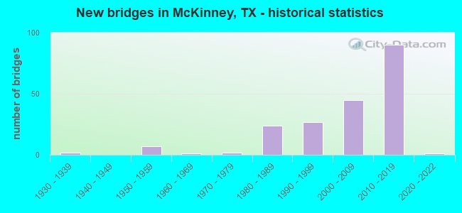
- New bridges - historical statistics
- 21930-1939
- 71950-1959
- 11960-1969
- 21970-1979
- 241980-1989
- 271990-1999
- 452000-2009
- 902010-2019
- 12020-2022

- Reconstructed bridges - Historical Statistics
- 21990-1999
- 72000-2009
- 102010-2019
- 22020-2022


- Bridge Condition - Deck
- 7.3%Very good
- 77.1%Good
- 14.6%Satisfactory
- 1.0%Fair

- Bridge Condition - Superstructure
- 51.0%Very good
- 36.5%Good
- 11.5%Satisfactory
- 1.0%Fair

- Bridge Condition - Substructure
- 10.4%Very good
- 62.5%Good
- 22.9%Satisfactory
- 4.2%Fair

- Bridge Condition - Channel
- 11.2%Very good
- 57.3%Good
- 28.0%Satisfactory
- 3.5%Fair

- Bridge Condition - Culverts
- 80.3%Good
- 19.7%Satisfactory
Find on map >> Show street view
Structure Number: 180430004705081, Location: 2.70 MI S OF US 380 (Lat: 33.173783, Lng: -96.621639), Route carried "on" structure: State highway 5, Year Built: 1957, Status: Open, Structure Length: 5.79m (19.00ft), Average Daily Traffic: 18,700 (year 2020), Truck Traffic: 6%, Average Future Daily Traffic: 26,485 (year 2040), Features Intersected: WILSON CREEK
Minimum Vertical Clearance: 30+ m (98+ ft), Kilometerpoint: 30.549, Lanes on structure: 2, Owner: State Highway Agency, Approaching Roadway Width: 10.4m (34.1ft), Material/Design: Concrete continuous, Design/Construction: Slab, Number Of Spans In Main Unit: 7, Length of Maximum Span: 9.1m (29.9ft), Curb-To-Curb Width: 9.1m (29.9ft), Out-to-Out Width: 10.2m (33.5ft)
Condition: Deck: Satisfactory, Superstructure: Satisfactory, Substructure: Satisfactory, Channel: Satisfactory, Operating Rating: 45.4 metric tons, Method Used To Determine Operating Rating: Load Factor (LF), Inventory Rating: 27.2 metric tons, Method Used To Determine Inventory Rating: Load Factor (LF), Structural Evaluation: Equal to present minimum criteria, Deck Geometry: Meets minimum limits, Waterway Adequacy: Equal to present minimum criteria, Approach Roadway Alignment: Equal to present desirable criteria, Designated Inspection Frequency: Every 24 months, Inspection Date: October 2021, Deck Structure Type: Concrete Cast-file-Place, Wearing Surface/Protective System: Wearing Surface: Bituminous
Find on map >> Show street view
Structure Number: 180430004705082, Location: 2.70 MI S OF US 380 (Lat: 33.173825, Lng: -96.621731), Route carried "on" structure: State highway 5, Year Built: 1957, Status: Open, Structure Length: 5.79m (19.00ft), Average Daily Traffic: 19,136 (year 2020), Truck Traffic: 6%, Average Future Daily Traffic: 26,485 (year 2040), Features Intersected: WILSON CREEK
Minimum Vertical Clearance: 30+ m (98+ ft), Kilometerpoint: 30.549, Lanes on structure: 2, Owner: State Highway Agency, Approaching Roadway Width: 11.0m (36.1ft), Material/Design: Concrete continuous, Design/Construction: Slab, Number Of Spans In Main Unit: 7, Length of Maximum Span: 9.1m (29.9ft), Curb-To-Curb Width: 9.1m (29.9ft), Out-to-Out Width: 10.2m (33.5ft)
Condition: Deck: Satisfactory, Superstructure: Satisfactory, Substructure: Fair, Channel: Satisfactory, Operating Rating: 45.4 metric tons, Method Used To Determine Operating Rating: Load Factor (LF), Inventory Rating: 27.2 metric tons, Method Used To Determine Inventory Rating: Load Factor (LF), Structural Evaluation: Somewhat better than minimum adequacy, Deck Geometry: Meets minimum limits, Waterway Adequacy: Equal to present minimum criteria, Approach Roadway Alignment: Equal to present desirable criteria, Designated Inspection Frequency: Every 24 months, Inspection Date: October 2021, Deck Structure Type: Concrete Cast-file-Place, Wearing Surface/Protective System: Wearing Surface: Bituminous
Find on map >> Show street view
Structure Number: 180430004705083, Location: 2.80 MI S OF US 380 (Lat: 33.172906, Lng: -96.622500), Route carried "on" structure: State highway 5, Year Built: 1957, Status: Open, Structure Length: 6.71m (22.01ft), Average Daily Traffic: 18,700 (year 2020), Truck Traffic: 6%, Average Future Daily Traffic: 26,485 (year 2040), Features Intersected: WILSON CREEK RELIEF
Minimum Vertical Clearance: 30+ m (98+ ft), Kilometerpoint: 30.672, Lanes on structure: 2, Base Highway Network: Yes, Owner: State Highway Agency, Approaching Roadway Width: 11.0m (36.1ft), Material/Design: Concrete continuous, Design/Construction: Slab, Number Of Spans In Main Unit: 8, Length of Maximum Span: 9.1m (29.9ft), Curb-To-Curb Width: 9.1m (29.9ft), Out-to-Out Width: 10.2m (33.5ft)
Condition: Deck: Satisfactory, Superstructure: Satisfactory, Substructure: Fair, Channel: Satisfactory, Operating Rating: 45.4 metric tons, Method Used To Determine Operating Rating: Load Factor (LF), Inventory Rating: 27.2 metric tons, Method Used To Determine Inventory Rating: Load Factor (LF), Structural Evaluation: Somewhat better than minimum adequacy, Deck Geometry: Meets minimum limits, Waterway Adequacy: Equal to present minimum criteria, Approach Roadway Alignment: Equal to present desirable criteria, Designated Inspection Frequency: Every 24 months, Inspection Date: October 2021, Deck Structure Type: Concrete Cast-file-Place, Wearing Surface/Protective System: Wearing Surface: Bituminous
Find on map >> Show street view
Structure Number: 180430004705084, Location: 2.80 MI S OF US 380 (Lat: 33.172956, Lng: -96.622592), Route carried "on" structure: State highway 5, Year Built: 1957, Status: Open, Structure Length: 6.71m (22.01ft), Average Daily Traffic: 19,136 (year 2020), Truck Traffic: 6%, Average Future Daily Traffic: 26,485 (year 2040), Features Intersected: WILSON CREEK RELIEF
Minimum Vertical Clearance: 30+ m (98+ ft), Kilometerpoint: 30.672, Lanes on structure: 2, Owner: State Highway Agency, Approaching Roadway Width: 11.0m (36.1ft), Material/Design: Concrete continuous, Design/Construction: Slab, Number Of Spans In Main Unit: 8, Length of Maximum Span: 9.1m (29.9ft), Curb-To-Curb Width: 9.1m (29.9ft), Out-to-Out Width: 10.2m (33.5ft)
Condition: Deck: Fair, Superstructure: Fair, Substructure: Fair, Channel: Satisfactory, Operating Rating: 45.4 metric tons, Method Used To Determine Operating Rating: Load Factor (LF), Inventory Rating: 27.2 metric tons, Method Used To Determine Inventory Rating: Load Factor (LF), Structural Evaluation: Somewhat better than minimum adequacy, Deck Geometry: Meets minimum limits, Waterway Adequacy: Equal to present minimum criteria, Approach Roadway Alignment: Equal to present desirable criteria, Designated Inspection Frequency: Every 24 months, Inspection Date: October 2021, Deck Structure Type: Concrete Cast-file-Place, Wearing Surface/Protective System: Wearing Surface: Bituminous
Find on map >> Show street view
Structure Number: 180430004705621, Location: 2.5 MI N OF US 380 (Lat: 33.247439, Lng: -96.606897), Route carried "on" structure: State highway 5, Year Built: 2012, Status: Open, Structure Length: 7.32m (24.02ft), Average Daily Traffic: 8,224 (year 2020), Truck Traffic: 8%, Average Future Daily Traffic: 11,514 (year 2040), Design Load: HL 93, Features Intersected: E FORK TRINITY RIVER REL
Minimum Vertical Clearance: 30+ m (98+ ft), Kilometerpoint: 21.972, Lanes on structure: 2, Owner: State Highway Agency, Approaching Roadway Width: 16.5m (54.1ft), Material/Design: Prestressed concrete, Design/Construction: Stringer/Multi-beam, Number Of Spans In Main Unit: 3, Length of Maximum Span: 27.4m (89.9ft), Curb-To-Curb Width: 16.5m (54.1ft), Out-to-Out Width: 17.1m (56.1ft)
Condition: Deck: Good, Superstructure: Good, Substructure: Good, Channel: Good, Operating Rating: 54.4 metric tons, Method Used To Determine Operating Rating: Assigned ratings based on Load and Resistance Factor Design (LRFD) reported in metric tons, Inventory Rating: 32.7 metric tons, Method Used To Determine Inventory Rating: Assigned ratings based on Load and Resistance Factor Design (LRFD) reported in metric tons, Structural Evaluation: Better than present minimum criteria, Deck Geometry: Superior to present desirable criteria, Waterway Adequacy: Superior to present desirable criteria, Approach Roadway Alignment: Equal to present desirable criteria, Designated Inspection Frequency: Every 24 months, Inspection Date: November 2021, Deck Structure Type: Concrete Cast-file-Place
Find on map >> Show street view
Structure Number: 180430004705622, Location: 2.25 MI N OF US 380 (Lat: 33.243683, Lng: -96.609181), Route carried "on" structure: State highway 5, Year Built: 2012, Status: Open, Structure Length: 15.39m (50.49ft), Average Daily Traffic: 8,224 (year 2020), Truck Traffic: 8%, Average Future Daily Traffic: 11,514 (year 2040), Design Load: HL 93, Features Intersected: E FORK TRINITY RIV
Minimum Vertical Clearance: 30+ m (98+ ft), Kilometerpoint: 22.444, Lanes on structure: 2, Owner: State Highway Agency, Approaching Roadway Width: 16.5m (54.1ft), Material/Design: Prestressed concrete, Design/Construction: Stringer/Multi-beam, Number Of Spans In Main Unit: 6, Length of Maximum Span: 27.4m (89.9ft), Curb-To-Curb Width: 16.5m (54.1ft), Out-to-Out Width: 17.1m (56.1ft)
Condition: Deck: Good, Superstructure: Good, Substructure: Good, Channel: Good, Operating Rating: 54.4 metric tons, Method Used To Determine Operating Rating: Assigned ratings based on Load and Resistance Factor Design (LRFD) reported in metric tons, Inventory Rating: 32.7 metric tons, Method Used To Determine Inventory Rating: Assigned ratings based on Load and Resistance Factor Design (LRFD) reported in metric tons, Structural Evaluation: Better than present minimum criteria, Deck Geometry: Superior to present desirable criteria, Waterway Adequacy: Superior to present desirable criteria, Approach Roadway Alignment: Equal to present desirable criteria, Designated Inspection Frequency: Every 24 months, Inspection Date: November 2021, Deck Structure Type: Concrete Cast-file-Place
Find on map >> Show street view
Structure Number: 180430004705623, Location: 2.1 MI N OF US 380 (Lat: 33.241617, Lng: -96.609800), Route carried "on" structure: State highway 5, Year Built: 2012, Status: Open, Structure Length: 7.92m (25.98ft), Average Daily Traffic: 8,224 (year 2020), Truck Traffic: 8%, Average Future Daily Traffic: 11,514 (year 2040), Design Load: HL 93, Features Intersected: E FORK TRINITY RIVER REL
Minimum Vertical Clearance: 30+ m (98+ ft), Kilometerpoint: 21.832, Lanes on structure: 2, Owner: State Highway Agency, Approaching Roadway Width: 16.5m (54.1ft), Material/Design: Prestressed concrete, Design/Construction: Stringer/Multi-beam, Number Of Spans In Main Unit: 3, Length of Maximum Span: 27.4m (89.9ft), Curb-To-Curb Width: 16.5m (54.1ft), Out-to-Out Width: 17.1m (56.1ft)
Condition: Deck: Good, Superstructure: Good, Substructure: Good, Channel: Good, Operating Rating: 54.4 metric tons, Method Used To Determine Operating Rating: Assigned ratings based on Load and Resistance Factor Design (LRFD) reported in metric tons, Inventory Rating: 32.7 metric tons, Method Used To Determine Inventory Rating: Assigned ratings based on Load and Resistance Factor Design (LRFD) reported in metric tons, Structural Evaluation: Better than present minimum criteria, Deck Geometry: Superior to present desirable criteria, Waterway Adequacy: Superior to present desirable criteria, Approach Roadway Alignment: Equal to present desirable criteria, Designated Inspection Frequency: Every 24 months, Inspection Date: November 2021, Deck Structure Type: Concrete Cast-file-Place
Find on map >> Show street view
Structure Number: 180430004706618, Location: AT INT OF SH 121 & US 75 (Lat: 33.158567, Lng: -96.644594), Route carried "on" structure: State highway 121, Year Built: 2011, Status: Open, Structure Length: 19.39m (63.62ft), Average Daily Traffic: 19,784 (year 2020), Truck Traffic: 6%, Average Future Daily Traffic: 27,699 (year 2040), Design Load: HL 93, Features Intersected: US 75
Minimum Vertical Clearance: 6.43m (21.10ft), Kilometerpoint: 18.332, Lanes on structure: 2, Lanes under structure: 14, Base Highway Network: Yes, Toll: On toll road, Owner: Local Toll Authority, Approaching Roadway Width: 17.7m (58.1ft), Skew: 4 degrees, Material/Design: Prestressed concrete, Design/Construction: Stringer/Multi-beam, Number Of Spans In Main Unit: 4, Number Of Approach Spans: 2, Length of Maximum Span: 40.5m (132.9ft), Curb-To-Curb Width: 17.7m (58.1ft), Out-to-Out Width: 18.3m (60.0ft)
Condition: Deck: Good, Superstructure: Very good, Substructure: Satisfactory, Operating Rating: 54.4 metric tons, Method Used To Determine Operating Rating: Assigned ratings based on Load and Resistance Factor Design (LRFD) reported in metric tons, Inventory Rating: 32.7 metric tons, Method Used To Determine Inventory Rating: Assigned ratings based on Load and Resistance Factor Design (LRFD) reported in metric tons, Structural Evaluation: Equal to present minimum criteria, Deck Geometry: Superior to present desirable criteria, Underclear: High priority of corrective action, Approach Roadway Alignment: Equal to present desirable criteria, Designated Inspection Frequency: Every 24 months, Inspection Date: October 2021, Deck Structure Type: Concrete Precast Panels
Find on map >> Show street view
Structure Number: 180430004706628, Location: 3.1 Mi S of US 380 (Lat: 33.172386, Lng: -96.641067), Route carried "on" structure: ServiceCity street , Year Built: 2014, Status: Open, Structure Length: 9.08m (29.79ft), Average Daily Traffic: 8,000 (year 2014), Average Future Daily Traffic: 10,000 (year 2034), Design Load: HL 93, Features Intersected: US 75, Facility Carried by Structure: El Dorado N T/A
Minimum Vertical Clearance: 30+ m (98+ ft), Kilometerpoint: 0.000, Lanes on structure: 1, Lanes under structure: 14, Owner: State Highway Agency, Approaching Roadway Width: 6.1m (20.0ft), Skew: 20 degrees, Material/Design: Prestressed concrete, Design/Construction: Stringer/Multi-beam, Number Of Spans In Main Unit: 2, Number Of Approach Spans: 2, Length of Maximum Span: 34.1m (111.9ft), Curb or Sidewalk Widths: Left: 0.0m, Right: 2.4m (7.9ft), Curb-To-Curb Width: 6.1m (20.0ft), Out-to-Out Width: 16.7m (54.8ft)
Condition: Deck: Good, Superstructure: Very good, Substructure: Good, Operating Rating: 54.4 metric tons, Method Used To Determine Operating Rating: Assigned ratings based on Load and Resistance Factor Design (LRFD) reported in metric tons, Inventory Rating: 32.7 metric tons, Method Used To Determine Inventory Rating: Assigned ratings based on Load and Resistance Factor Design (LRFD) reported in metric tons, Structural Evaluation: Better than present minimum criteria, Deck Geometry: High priority of replacement, Underclear: High priority of corrective action, Approach Roadway Alignment: Equal to present desirable criteria, Designated Inspection Frequency: Every 24 months, Inspection Date: October 2021, Deck Structure Type: Concrete Precast Panels
Find on map >> Show street view
Structure Number: 180430004706629, Location: AT INT ELDO PKWY & US 75 (Lat: 33.171883, Lng: -96.640775), Route carried "on" structure: City street , Year Built: 2017, Status: Open, Structure Length: 9.05m (29.69ft), Average Daily Traffic: 25,380 (year 2016), Truck Traffic: 10%, Average Future Daily Traffic: 44,770 (year 2035), Design Load: HL 93, Features Intersected: US 75, Facility Carried by Structure: ELDORADO PKWY
Minimum Vertical Clearance: 30+ m (98+ ft), Kilometerpoint: 9.862, Lanes on structure: 7, Lanes under structure: 12, Owner: State Highway Agency, Approaching Roadway Width: 26.8m (87.9ft), Material/Design: Prestressed concrete, Design/Construction: Stringer/Multi-beam, Number Of Spans In Main Unit: 2, Number Of Approach Spans: 2, Length of Maximum Span: 34.1m (111.9ft), Curb or Sidewalk Widths: Left: 3.0m (9.8ft), Right: 2.4m (7.9ft), Curb-To-Curb Width: 26.8m (87.9ft), Out-to-Out Width: 36.3m (119.1ft)
Condition: Deck: Satisfactory, Superstructure: Very good, Substructure: Good, Operating Rating: 54.4 metric tons, Method Used To Determine Operating Rating: Assigned ratings based on Load and Resistance Factor Design (LRFD) reported in metric tons, Inventory Rating: 32.7 metric tons, Method Used To Determine Inventory Rating: Assigned ratings based on Load and Resistance Factor Design (LRFD) reported in metric tons, Structural Evaluation: Better than present minimum criteria, Deck Geometry: Somewhat better than minimum adequacy, Underclear: High priority of corrective action, Approach Roadway Alignment: Equal to present desirable criteria, Designated Inspection Frequency: Every 24 months, Inspection Date: October 2021, Deck Structure Type: Concrete Precast Panels, Wearing Surface/Protective System: Deck Protection: Epoxy Coated Reinforcing
Find on map >> Show street view
Structure Number: 18043000470663, Location: AT INT ELDO PKWY & US 75 (Lat: 33.171936, Lng: -96.640569), Route carried "on" structure: ServiceCity street , Year Built: 2017, Status: Open, Structure Length: 9.06m (29.72ft), Average Daily Traffic: 25,380 (year 2016), Truck Traffic: 10%, Average Future Daily Traffic: 44,770 (year 2035), Design Load: HL 93, Features Intersected: US 75, Facility Carried by Structure: ELDORADO PKWY STA
Minimum Vertical Clearance: 30+ m (98+ ft), Kilometerpoint: 9.862, Lanes on structure: 1, Lanes under structure: 12, Owner: State Highway Agency, Approaching Roadway Width: 4.3m (14.1ft), Skew: 20 degrees, Material/Design: Prestressed concrete, Design/Construction: Stringer/Multi-beam, Number Of Spans In Main Unit: 2, Number Of Approach Spans: 2, Length of Maximum Span: 34.1m (111.9ft), Curb or Sidewalk Widths: Left: 4.6m (15.1ft), Right: 3.0m (9.8ft), Curb-To-Curb Width: 4.3m (14.1ft), Out-to-Out Width: 13.4m (44.0ft)
Condition: Deck: Good, Superstructure: Very good, Substructure: Good, Operating Rating: 54.4 metric tons, Method Used To Determine Operating Rating: Assigned ratings based on Load and Resistance Factor Design (LRFD) reported in metric tons, Inventory Rating: 32.7 metric tons, Method Used To Determine Inventory Rating: Assigned ratings based on Load and Resistance Factor Design (LRFD) reported in metric tons, Structural Evaluation: Better than present minimum criteria, Deck Geometry: High priority of replacement, Underclear: High priority of corrective action, Approach Roadway Alignment: Equal to present desirable criteria, Designated Inspection Frequency: Every 24 months, Inspection Date: October 2021, Deck Structure Type: Concrete Precast Panels, Wearing Surface/Protective System: Deck Protection: Epoxy Coated Reinforcing
Find on map >> Show street view
Structure Number: 180430004706631, Location: 2.50 MI S OF US 380 (Lat: 33.179389, Lng: -96.639864), Route carried "on" structure: US 75, Year Built: 2015, Status: Open, Structure Length: 3.66m (12.01ft), Average Daily Traffic: 58,081 (year 2018), Truck Traffic: 10%, Average Future Daily Traffic: 81,314 (year 2038), Design Load: HL 93, Features Intersected: COMEGYS CREEK
Minimum Vertical Clearance: 30+ m (98+ ft), Kilometerpoint: 0.557, Lanes on structure: 5, Base Highway Network: Yes, Owner: State Highway Agency, Approaching Roadway Width: 24.4m (80.1ft), Skew: 30 degrees, Material/Design: Prestressed concrete, Design/Construction: Stringer/Multi-beam, Number Of Spans In Main Unit: 1, Length of Maximum Span: 36.6m (120.1ft), Curb-To-Curb Width: 24.4m (80.1ft), Out-to-Out Width: 29.9m (98.1ft)
Condition: Deck: Satisfactory, Superstructure: Very good, Substructure: Good, Channel: Good, Operating Rating: 54.4 metric tons, Method Used To Determine Operating Rating: Assigned ratings based on Load and Resistance Factor Design (LRFD) reported in metric tons, Inventory Rating: 32.7 metric tons, Method Used To Determine Inventory Rating: Assigned ratings based on Load and Resistance Factor Design (LRFD) reported in metric tons, Structural Evaluation: Better than present minimum criteria, Deck Geometry: Equal to present minimum criteria, Waterway Adequacy: Superior to present desirable criteria, Approach Roadway Alignment: Equal to present desirable criteria, Designated Inspection Frequency: Every 24 months, Inspection Date: October 2021, Deck Structure Type: Concrete Precast Panels, Wearing Surface/Protective System: Deck Protection: Epoxy Coated Reinforcing
Find on map >> Show street view
Structure Number: 180430004706632, Location: SBML (Lat: 33.179425, Lng: -96.640100), Route carried "on" structure: US 75, Year Built: 2015, Status: Open, Structure Length: 3.66m (12.01ft), Average Daily Traffic: 58,081 (year 2018), Truck Traffic: 10%, Average Future Daily Traffic: 81,314 (year 2038), Design Load: HL 93, Features Intersected: COMEGYS CREEK
Minimum Vertical Clearance: 30+ m (98+ ft), Kilometerpoint: 0.557, Lanes on structure: 4, Base Highway Network: Yes, Owner: State Highway Agency, Approaching Roadway Width: 20.7m (67.9ft), Skew: 30 degrees, Material/Design: Prestressed concrete, Design/Construction: Stringer/Multi-beam, Number Of Spans In Main Unit: 1, Length of Maximum Span: 36.6m (120.1ft), Curb-To-Curb Width: 20.7m (67.9ft), Out-to-Out Width: 26.2m (86.0ft)
Condition: Deck: Satisfactory, Superstructure: Very good, Substructure: Good, Channel: Good, Operating Rating: 54.4 metric tons, Method Used To Determine Operating Rating: Assigned ratings based on Load and Resistance Factor Design (LRFD) reported in metric tons, Inventory Rating: 32.7 metric tons, Method Used To Determine Inventory Rating: Assigned ratings based on Load and Resistance Factor Design (LRFD) reported in metric tons, Structural Evaluation: Better than present minimum criteria, Deck Geometry: Equal to present minimum criteria, Waterway Adequacy: Superior to present desirable criteria, Approach Roadway Alignment: Equal to present desirable criteria, Designated Inspection Frequency: Every 24 months, Inspection Date: October 2021, Deck Structure Type: Concrete Precast Panels, Wearing Surface/Protective System: Deck Protection: Epoxy Coated Reinforcing
Find on map >> Show street view
Structure Number: 180430004706633, Location: 2.50 MI S OF US 380 (Lat: 33.179450, Lng: -96.639458), Route carried "on" structure: ServiceUS 75, Year Built: 2015, Status: Open, Structure Length: 2.38m (7.81ft), Average Daily Traffic: 5,368 (year 2018), Truck Traffic: 4%, Average Future Daily Traffic: 7,520 (year 2038), Design Load: HL 93, Features Intersected: COMEGYS CREEK
Minimum Vertical Clearance: 30+ m (98+ ft), Kilometerpoint: 0.557, Lanes on structure: 3, Owner: State Highway Agency, Approaching Roadway Width: 12.2m (40.0ft), Material/Design: Prestressed concrete, Design/Construction: Stringer/Multi-beam, Number Of Spans In Main Unit: 1, Length of Maximum Span: 23.8m (78.1ft), Curb-To-Curb Width: 12.2m (40.0ft), Out-to-Out Width: 12.8m (42.0ft)
Condition: Deck: Good, Superstructure: Very good, Substructure: Satisfactory, Channel: Good, Operating Rating: 54.4 metric tons, Method Used To Determine Operating Rating: Assigned ratings based on Load and Resistance Factor Design (LRFD) reported in metric tons, Inventory Rating: 32.7 metric tons, Method Used To Determine Inventory Rating: Assigned ratings based on Load and Resistance Factor Design (LRFD) reported in metric tons, Structural Evaluation: Equal to present minimum criteria, Deck Geometry: Meets minimum limits, Waterway Adequacy: Superior to present desirable criteria, Approach Roadway Alignment: Equal to present desirable criteria, Designated Inspection Frequency: Every 24 months, Inspection Date: October 2021, Deck Structure Type: Concrete Precast Panels, Wearing Surface/Protective System: Deck Protection: Epoxy Coated Reinforcing
Find on map >> Show street view
Structure Number: 180430004706634, Location: 2.6 Mi S of US 380 (Lat: 33.179669, Lng: -96.640500), Route carried "on" structure: ServiceUS 75, Year Built: 2014, Status: Open, Structure Length: 2.38m (7.81ft), Average Daily Traffic: 7,918 (year 2018), Truck Traffic: 4%, Average Future Daily Traffic: 11,085 (year 2038), Design Load: HL 93, Features Intersected: Comegys Creek
Minimum Vertical Clearance: 30+ m (98+ ft), Kilometerpoint: 0.000, Lanes on structure: 3, Owner: State Highway Agency, Approaching Roadway Width: 12.2m (40.0ft), Material/Design: Prestressed concrete, Design/Construction: Stringer/Multi-beam, Number Of Spans In Main Unit: 1, Length of Maximum Span: 23.8m (78.1ft), Curb-To-Curb Width: 12.2m (40.0ft), Out-to-Out Width: 12.8m (42.0ft)
Condition: Deck: Good, Superstructure: Very good, Substructure: Satisfactory, Channel: Fair, Operating Rating: 54.4 metric tons, Method Used To Determine Operating Rating: Assigned ratings based on Load and Resistance Factor Design (LRFD) reported in metric tons, Inventory Rating: 32.7 metric tons, Method Used To Determine Inventory Rating: Assigned ratings based on Load and Resistance Factor Design (LRFD) reported in metric tons, Structural Evaluation: Equal to present minimum criteria, Deck Geometry: Meets minimum limits, Waterway Adequacy: Superior to present desirable criteria, Approach Roadway Alignment: Equal to present desirable criteria, Designated Inspection Frequency: Every 24 months, Inspection Date: October 2021, Deck Structure Type: Concrete Precast Panels, Wearing Surface/Protective System: Deck Protection: Epoxy Coated Reinforcing
Find on map >> Show street view
Structure Number: 180430004706635, Location: 1 MI N OF ELDORADO PKWY (Lat: 33.179692, Lng: -96.639656), Route carried "on" structure: Ramp US 75, Year Built: 2017, Status: Open, Structure Length: 2.38m (7.81ft), Average Daily Traffic: 4,500 (year 2005), Truck Traffic: 97%, Average Future Daily Traffic: 7,200 (year 2025), Design Load: HL 93, Features Intersected: COMEGYS CREEK
Minimum Vertical Clearance: 30+ m (98+ ft), Kilometerpoint: 21.432, Lanes on structure: 1, Owner: State Highway Agency, Approaching Roadway Width: 7.3m (24.0ft), Material/Design: Prestressed concrete, Design/Construction: Stringer/Multi-beam, Number Of Spans In Main Unit: 1, Length of Maximum Span: 23.8m (78.1ft), Curb-To-Curb Width: 7.3m (24.0ft), Out-to-Out Width: 7.9m (25.9ft)
Condition: Deck: Good, Superstructure: Very good, Substructure: Good, Channel: Good, Operating Rating: 54.4 metric tons, Method Used To Determine Operating Rating: Assigned ratings based on Load and Resistance Factor Design (LRFD) reported in metric tons, Inventory Rating: 32.7 metric tons, Method Used To Determine Inventory Rating: Assigned ratings based on Load and Resistance Factor Design (LRFD) reported in metric tons, Structural Evaluation: Better than present minimum criteria, Deck Geometry: Better than present minimum criteria, Waterway Adequacy: Superior to present desirable criteria, Approach Roadway Alignment: Equal to present desirable criteria, Designated Inspection Frequency: Every 24 months, Inspection Date: October 2021, Deck Structure Type: Concrete Precast Panels, Wearing Surface/Protective System: Deck Protection: Epoxy Coated Reinforcing
Find on map >> Show street view
Structure Number: 180430004714164, Location: 2.20 MI S OF US 380 (Lat: 33.185261, Lng: -96.640158), Route carried "on" structure: ServiceUS 75, Year Built: 1965, Status: Open, Structure Length: 2.44m (8.01ft), Average Daily Traffic: 3,484 (year 2020), Truck Traffic: 3%, Average Future Daily Traffic: 4,878 (year 2040), Design Load: H 20, Features Intersected: WILSON CREEK, Facility Carried by Structure: CREEK TRAIL BRIDGE
Minimum Vertical Clearance: 30+ m (98+ ft), Kilometerpoint: 25.320, Lanes on structure: 2, Owner: State Highway Agency, Approaching Roadway Width: 9.1m (29.9ft), Material/Design: Concrete continuous, Design/Construction: Slab, Number Of Spans In Main Unit: 3, Length of Maximum Span: 9.1m (29.9ft), Curb-To-Curb Width: 9.1m (29.9ft), Out-to-Out Width: 9.8m (32.2ft)
Condition: Deck: Satisfactory, Superstructure: Satisfactory, Substructure: Satisfactory, Channel: Satisfactory, Operating Rating: 32.7 metric tons, Method Used To Determine Operating Rating: Field evaluation and documented engineering judgment, Inventory Rating: 24.5 metric tons, Method Used To Determine Inventory Rating: Field evaluation and documented engineering judgment, Structural Evaluation: Equal to present minimum criteria, Deck Geometry: Meets minimum limits, Waterway Adequacy: Equal to present minimum criteria, Approach Roadway Alignment: Equal to present desirable criteria, Length Of Structure Improvement: 2.44m (8.01ft), Designated Inspection Frequency: Every 24 months, Inspection Date: September 2021, Bridge Improvement Cost: $5,000, Roadway Improvement Cost: $1,000, Total Project Cost: $6,000, Deck Structure Type: Concrete Cast-file-Place
Find on map >> Show street view
Structure Number: 180430004714607, Location: 2.6 MI S OF FM 543 (Lat: 33.217094, Lng: -96.636381), Route carried "on" structure: US 75, Year Built: 2010, Status: Open, Structure Length: 9.75m (31.99ft), Average Daily Traffic: 37,963 (year 2019), Truck Traffic: 7%, Average Future Daily Traffic: 50,610 (year 2033), Design Load: HL 93, Features Intersected: US 380
Minimum Vertical Clearance: 30+ m (98+ ft), Kilometerpoint: 21.816, Lanes on structure: 4, Lanes under structure: 10, Owner: State Highway Agency, Approaching Roadway Width: 17.4m (57.1ft), Skew: 1 degrees, Material/Design: Prestressed concrete, Design/Construction: Stringer/Multi-beam, Number Of Spans In Main Unit: 3, Length of Maximum Span: 36.6m (120.1ft), Curb-To-Curb Width: 17.5m (57.4ft), Out-to-Out Width: 25.2m (82.7ft)
Condition: Deck: Good, Superstructure: Very good, Substructure: Good, Operating Rating: 54.4 metric tons, Method Used To Determine Operating Rating: Assigned ratings based on Load and Resistance Factor Design (LRFD) reported in metric tons, Inventory Rating: 32.7 metric tons, Method Used To Determine Inventory Rating: Assigned ratings based on Load and Resistance Factor Design (LRFD) reported in metric tons, Structural Evaluation: Better than present minimum criteria, Deck Geometry: Meets minimum limits, Underclear: Meets minimum limits, Approach Roadway Alignment: Equal to present desirable criteria, Designated Inspection Frequency: Every 24 months, Inspection Date: September 2021, Deck Structure Type: Concrete Cast-file-Place
Find on map >> Show street view
Structure Number: 180430004714608, Location: 2.6 MI S OF FM 543 (Lat: 33.217094, Lng: -96.636381), Route carried "on" structure: US 75, Year Built: 2011, Status: Open, Structure Length: 9.75m (31.99ft), Average Daily Traffic: 39,361 (year 2019), Truck Traffic: 7%, Average Future Daily Traffic: 50,610 (year 2033), Design Load: HL 93, Features Intersected: US 380
Minimum Vertical Clearance: 30+ m (98+ ft), Kilometerpoint: 21.816, Lanes on structure: 4, Lanes under structure: 10, Base Highway Network: Yes, Owner: State Highway Agency, Approaching Roadway Width: 17.7m (58.1ft), Skew: 1 degrees, Material/Design: Prestressed concrete, Design/Construction: Stringer/Multi-beam, Number Of Spans In Main Unit: 3, Length of Maximum Span: 36.6m (120.1ft), Curb-To-Curb Width: 17.7m (58.1ft), Out-to-Out Width: 25.3m (83.0ft)
Condition: Deck: Good, Superstructure: Very good, Substructure: Good, Operating Rating: 54.4 metric tons, Method Used To Determine Operating Rating: Assigned ratings based on Load and Resistance Factor Design (LRFD) reported in metric tons, Inventory Rating: 32.7 metric tons, Method Used To Determine Inventory Rating: Assigned ratings based on Load and Resistance Factor Design (LRFD) reported in metric tons, Structural Evaluation: Better than present minimum criteria, Deck Geometry: Meets minimum limits, Underclear: Meets minimum limits, Approach Roadway Alignment: Equal to present desirable criteria, Designated Inspection Frequency: Every 24 months, Inspection Date: September 2021, Deck Structure Type: Concrete Cast-file-Place
Find on map >> Show street view
Structure Number: 180430004714624, Location: 0.85 MI N OF US 380 (Lat: 33.229017, Lng: -96.632850), Route carried "on" structure: US 75, Year Built: 2012, Status: Open, Structure Length: 9.51m (31.20ft), Average Daily Traffic: 36,342 (year 2020), Truck Traffic: 14%, Average Future Daily Traffic: 72,685 (year 2040), Design Load: HL 93, Features Intersected: WILMETH ROAD
Minimum Vertical Clearance: 5.18m (16.99ft), Kilometerpoint: 4.826, Lanes on structure: 4, Lanes under structure: 10, Owner: State Highway Agency, Approaching Roadway Width: 28.3m (92.8ft), Skew: 1 degrees, Material/Design: Prestressed concrete, Design/Construction: Stringer/Multi-beam, Number Of Spans In Main Unit: 3, Length of Maximum Span: 35.4m (116.1ft), Curb-To-Curb Width: 28.3m (92.8ft), Out-to-Out Width: 29.0m (95.1ft)
Condition: Deck: Good, Superstructure: Good, Substructure: Good, Operating Rating: 54.4 metric tons, Method Used To Determine Operating Rating: Assigned ratings based on Load and Resistance Factor Design (LRFD) reported in metric tons, Inventory Rating: 32.7 metric tons, Method Used To Determine Inventory Rating: Assigned ratings based on Load and Resistance Factor Design (LRFD) reported in metric tons, Structural Evaluation: Better than present minimum criteria, Deck Geometry: Superior to present desirable criteria, Underclear: Meets minimum limits, Approach Roadway Alignment: Equal to present desirable criteria, Designated Inspection Frequency: Every 24 months, Inspection Date: September 2021, Deck Structure Type: Concrete Cast-file-Place
Find on map >> Show street view
Structure Number: 180430004714625, Location: 0.85 MI N of US 380 (Lat: 33.229194, Lng: -96.632961), Route carried "on" structure: US 75, Year Built: 2012, Status: Open, Structure Length: 9.51m (31.20ft), Average Daily Traffic: 36,342 (year 2020), Truck Traffic: 14%, Average Future Daily Traffic: 72,685 (year 2040), Design Load: HL 93, Features Intersected: WILMETH RD
Minimum Vertical Clearance: 30+ m (98+ ft), Kilometerpoint: 20.382, Lanes on structure: 5, Lanes under structure: 10, Base Highway Network: Yes, Owner: State Highway Agency, Approaching Roadway Width: 28.7m (94.2ft), Skew: 1 degrees, Material/Design: Prestressed concrete, Design/Construction: Stringer/Multi-beam, Number Of Spans In Main Unit: 3, Length of Maximum Span: 35.4m (116.1ft), Curb-To-Curb Width: 28.3m (92.8ft), Out-to-Out Width: 29.0m (95.1ft)
Condition: Deck: Good, Superstructure: Very good, Substructure: Satisfactory, Operating Rating: 54.4 metric tons, Method Used To Determine Operating Rating: Assigned ratings based on Load and Resistance Factor Design (LRFD) reported in metric tons, Inventory Rating: 32.7 metric tons, Method Used To Determine Inventory Rating: Assigned ratings based on Load and Resistance Factor Design (LRFD) reported in metric tons, Structural Evaluation: Equal to present minimum criteria, Deck Geometry: Superior to present desirable criteria, Underclear: Meets minimum limits, Approach Roadway Alignment: Equal to present desirable criteria, Designated Inspection Frequency: Every 24 months, Inspection Date: September 2021, Deck Structure Type: Concrete Cast-file-Place
Find on map >> Show street view
Structure Number: 180430004714636, Location: 2.20 MI S Of US 380 (Lat: 33.185139, Lng: -96.639525), Route carried "on" structure: US 75, Year Built: 2015, Status: Open, Structure Length: 13.41m (44.00ft), Average Daily Traffic: 47,521 (year 2020), Truck Traffic: 10%, Average Future Daily Traffic: 95,042 (year 2040), Design Load: HL 93, Features Intersected: WILSON CRK & PARK VIEW
Minimum Vertical Clearance: 30+ m (98+ ft), Kilometerpoint: 25.252, Lanes on structure: 4, Lanes under structure: 4, Owner: State Highway Agency, Approaching Roadway Width: 24.4m (80.1ft), Skew: 10 degrees, Material/Design: Prestressed concrete, Design/Construction: Stringer/Multi-beam, Number Of Spans In Main Unit: 4, Length of Maximum Span: 38.1m (125.0ft), Curb-To-Curb Width: 24.4m (80.1ft), Out-to-Out Width: 29.9m (98.1ft)
Condition: Deck: Good, Superstructure: Very good, Substructure: Good, Channel: Good, Operating Rating: 54.4 metric tons, Method Used To Determine Operating Rating: Assigned ratings based on Load and Resistance Factor Design (LRFD) reported in metric tons, Inventory Rating: 32.7 metric tons, Method Used To Determine Inventory Rating: Assigned ratings based on Load and Resistance Factor Design (LRFD) reported in metric tons, Structural Evaluation: Better than present minimum criteria, Deck Geometry: Superior to present desirable criteria, Underclear: Equal to present desirable criteria, Waterway Adequacy: Superior to present desirable criteria, Approach Roadway Alignment: Equal to present desirable criteria, Designated Inspection Frequency: Every 24 months, Inspection Date: September 2021, Deck Structure Type: Concrete Cast-file-Place, Wearing Surface/Protective System: Deck Protection: Epoxy Coated Reinforcing
Find on map >> Show street view
Structure Number: 180430004714637, Location: 2.20 MI S Of US 380 (Lat: 33.185161, Lng: -96.639761), Route carried "on" structure: US 75, Year Built: 2015, Status: Open, Structure Length: 13.41m (44.00ft), Average Daily Traffic: 47,521 (year 2020), Truck Traffic: 10%, Average Future Daily Traffic: 95,042 (year 2040), Design Load: HL 93, Features Intersected: WILSON CRK & PARK VIEW
Minimum Vertical Clearance: 30+ m (98+ ft), Kilometerpoint: 25.252, Lanes on structure: 5, Lanes under structure: 4, Owner: State Highway Agency, Approaching Roadway Width: 24.4m (80.1ft), Skew: 10 degrees, Material/Design: Prestressed concrete, Design/Construction: Stringer/Multi-beam, Number Of Spans In Main Unit: 4, Length of Maximum Span: 38.1m (125.0ft), Curb-To-Curb Width: 24.4m (80.1ft), Out-to-Out Width: 29.9m (98.1ft)
Condition: Deck: Satisfactory, Superstructure: Very good, Substructure: Good, Channel: Good, Operating Rating: 54.4 metric tons, Method Used To Determine Operating Rating: Assigned ratings based on Load and Resistance Factor Design (LRFD) reported in metric tons, Inventory Rating: 32.7 metric tons, Method Used To Determine Inventory Rating: Assigned ratings based on Load and Resistance Factor Design (LRFD) reported in metric tons, Structural Evaluation: Better than present minimum criteria, Deck Geometry: Equal to present minimum criteria, Underclear: Better than present minimum criteria, Waterway Adequacy: Superior to present desirable criteria, Approach Roadway Alignment: Equal to present desirable criteria, Designated Inspection Frequency: Every 24 months, Inspection Date: September 2021, Deck Structure Type: Concrete Cast-file-Place, Wearing Surface/Protective System: Deck Protection: Epoxy Coated Reinforcing
Find on map >> Show street view
Structure Number: 180430004714638, Location: 1.8 MI N OF TX 121 (Lat: 33.185097, Lng: -96.639236), Route carried "on" structure: ServiceUS 75, Year Built: 2016, Status: Open, Structure Length: 13.47m (44.19ft), Average Daily Traffic: 5,135 (year 2020), Truck Traffic: 7%, Average Future Daily Traffic: 7,189 (year 2040), Design Load: HL 93, Features Intersected: Wilson Crk & City Street
Minimum Vertical Clearance: 30+ m (98+ ft), Kilometerpoint: 0.000, Lanes on structure: 4, Lanes under structure: 4, Owner: State Highway Agency, Approaching Roadway Width: 14.6m (47.9ft), Material/Design: Prestressed concrete, Design/Construction: Stringer/Multi-beam, Number Of Spans In Main Unit: 4, Length of Maximum Span: 38.1m (125.0ft), Curb-To-Curb Width: 15.9m (52.2ft), Out-to-Out Width: 16.5m (54.1ft)
Condition: Deck: Good, Superstructure: Very good, Substructure: Good, Channel: Good, Operating Rating: 54.4 metric tons, Method Used To Determine Operating Rating: Assigned ratings based on Load and Resistance Factor Design (LRFD) reported in metric tons, Inventory Rating: 32.7 metric tons, Method Used To Determine Inventory Rating: Assigned ratings based on Load and Resistance Factor Design (LRFD) reported in metric tons, Structural Evaluation: Better than present minimum criteria, Deck Geometry: Meets minimum limits, Underclear: Superior to present desirable criteria, Waterway Adequacy: Superior to present desirable criteria, Approach Roadway Alignment: Equal to present desirable criteria, Designated Inspection Frequency: Every 24 months, Inspection Date: September 2021, Deck Structure Type: Concrete Cast-file-Place
Find on map >> Show street view
Structure Number: 180430004714639, Location: 1.8 MI N OF TX 121 (Lat: 33.185128, Lng: -96.640053), Route carried "on" structure: ServiceUS 75, Year Built: 2016, Status: Open, Structure Length: 13.47m (44.19ft), Average Daily Traffic: 7,265 (year 2020), Truck Traffic: 7%, Average Future Daily Traffic: 10,171 (year 2040), Design Load: HL 93, Features Intersected: Wilson Crk & City Sts
Minimum Vertical Clearance: 30+ m (98+ ft), Kilometerpoint: 0.000, Lanes on structure: 2, Lanes under structure: 4, Owner: State Highway Agency, Approaching Roadway Width: 8.5m (27.9ft), Material/Design: Prestressed concrete, Design/Construction: Stringer/Multi-beam, Number Of Spans In Main Unit: 4, Length of Maximum Span: 38.1m (125.0ft), Curb-To-Curb Width: 8.5m (27.9ft), Out-to-Out Width: 9.1m (29.9ft)
Condition: Deck: Good, Superstructure: Very good, Substructure: Good, Channel: Good, Operating Rating: 54.4 metric tons, Method Used To Determine Operating Rating: Assigned ratings based on Load and Resistance Factor Design (LRFD) reported in metric tons, Inventory Rating: 32.7 metric tons, Method Used To Determine Inventory Rating: Assigned ratings based on Load and Resistance Factor Design (LRFD) reported in metric tons, Structural Evaluation: Better than present minimum criteria, Deck Geometry: High priority of corrective action, Underclear: Better than present minimum criteria, Waterway Adequacy: Superior to present desirable criteria, Approach Roadway Alignment: Equal to present desirable criteria, Designated Inspection Frequency: Every 24 months, Inspection Date: September 2021, Deck Structure Type: Concrete Cast-file-Place
Find on map >> Show street view
Structure Number: 18043000471464, Location: 1.30 MI S OF US 380 (Lat: 33.198289, Lng: -96.638731), Route carried "on" structure: US 75, Year Built: 2015, Status: Open, Structure Length: 11.03m (36.19ft), Average Daily Traffic: 47,521 (year 2020), Truck Traffic: 10%, Average Future Daily Traffic: 95,042 (year 2040), Design Load: HL 93, Features Intersected: SPUR 359/FM 3038
Minimum Vertical Clearance: 30+ m (98+ ft), Kilometerpoint: 23.833, Lanes on structure: 5, Lanes under structure: 10, Base Highway Network: Yes, Owner: State Highway Agency, Approaching Roadway Width: 24.4m (80.1ft), Skew: 30 degrees, Material/Design: Prestressed concrete, Design/Construction: Stringer/Multi-beam, Number Of Spans In Main Unit: 3, Length of Maximum Span: 37.8m (124.0ft), Curb-To-Curb Width: 24.4m (80.1ft), Out-to-Out Width: 29.9m (98.1ft)
Condition: Deck: Good, Superstructure: Very good, Substructure: Very good, Operating Rating: 54.4 metric tons, Method Used To Determine Operating Rating: Assigned ratings based on Load and Resistance Factor Design (LRFD) reported in metric tons, Inventory Rating: 32.7 metric tons, Method Used To Determine Inventory Rating: Assigned ratings based on Load and Resistance Factor Design (LRFD) reported in metric tons, Structural Evaluation: Equal to present desirable criteria, Deck Geometry: Equal to present minimum criteria, Underclear: High priority of corrective action, Approach Roadway Alignment: Equal to present desirable criteria, Designated Inspection Frequency: Every 24 months, Inspection Date: November 2021, Deck Structure Type: Concrete Cast-file-Place
Find on map >> Show street view
Structure Number: 180430004714641, Location: 1.30 MI S OF US 380 (Lat: 33.198317, Lng: -96.638978), Route carried "on" structure: US 75, Year Built: 2017, Status: Open, Structure Length: 11.03m (36.19ft), Average Daily Traffic: 47,521 (year 2020), Truck Traffic: 10%, Average Future Daily Traffic: 95,042 (year 2040), Design Load: HL 93, Features Intersected: FM 3038/Spur 359
Minimum Vertical Clearance: 30+ m (98+ ft), Kilometerpoint: 23.833, Lanes on structure: 5, Lanes under structure: 10, Base Highway Network: Yes, Owner: State Highway Agency, Approaching Roadway Width: 24.4m (80.1ft), Skew: 30 degrees, Material/Design: Prestressed concrete, Design/Construction: Stringer/Multi-beam, Number Of Spans In Main Unit: 3, Length of Maximum Span: 37.8m (124.0ft), Curb-To-Curb Width: 24.4m (80.1ft), Out-to-Out Width: 29.9m (98.1ft)
Condition: Deck: Satisfactory, Superstructure: Good, Substructure: Good, Operating Rating: 54.4 metric tons, Method Used To Determine Operating Rating: Assigned ratings based on Load and Resistance Factor Design (LRFD) reported in metric tons, Inventory Rating: 32.7 metric tons, Method Used To Determine Inventory Rating: Assigned ratings based on Load and Resistance Factor Design (LRFD) reported in metric tons, Structural Evaluation: Better than present minimum criteria, Deck Geometry: Equal to present minimum criteria, Underclear: Meets minimum limits, Approach Roadway Alignment: Equal to present desirable criteria, Designated Inspection Frequency: Every 24 months, Inspection Date: November 2021, Deck Structure Type: Concrete Cast-file-Place
Find on map >> Show street view
Structure Number: 180430004714642, Location: 0.50 MI S OF US 380 (Lat: 33.209800, Lng: -96.637889), Route carried "on" structure: US 75, Year Built: 2015, Status: Open, Structure Length: 7.34m (24.08ft), Average Daily Traffic: 47,521 (year 2020), Truck Traffic: 10%, Average Future Daily Traffic: 95,042 (year 2040), Design Load: HL 93, Features Intersected: WHITE AVE
Minimum Vertical Clearance: 30+ m (98+ ft), Kilometerpoint: 22.568, Lanes on structure: 5, Lanes under structure: 5, Base Highway Network: Yes, Owner: State Highway Agency, Approaching Roadway Width: 24.4m (80.1ft), Skew: 30 degrees, Material/Design: Prestressed concrete, Design/Construction: Stringer/Multi-beam, Number Of Spans In Main Unit: 3, Length of Maximum Span: 27.6m (90.6ft), Curb-To-Curb Width: 24.4m (80.1ft), Out-to-Out Width: 29.9m (98.1ft)
Condition: Deck: Good, Superstructure: Good, Substructure: Good, Operating Rating: 54.4 metric tons, Method Used To Determine Operating Rating: Assigned ratings based on Load and Resistance Factor Design (LRFD) reported in metric tons, Inventory Rating: 32.7 metric tons, Method Used To Determine Inventory Rating: Assigned ratings based on Load and Resistance Factor Design (LRFD) reported in metric tons, Structural Evaluation: Better than present minimum criteria, Deck Geometry: Equal to present minimum criteria, Underclear: Meets minimum limits, Approach Roadway Alignment: Equal to present desirable criteria, Designated Inspection Frequency: Every 24 months, Inspection Date: November 2021, Deck Structure Type: Concrete Precast Panels
Find on map >> Show street view
Structure Number: 180430004714643, Location: 0.5 MI S OF US 380 (Lat: 33.209808, Lng: -96.638119), Route carried "on" structure: US 75, Year Built: 2015, Status: Open, Structure Length: 7.34m (24.08ft), Average Daily Traffic: 47,521 (year 2020), Truck Traffic: 10%, Average Future Daily Traffic: 95,042 (year 2040), Design Load: HL 93, Features Intersected: WHITE AVE
Minimum Vertical Clearance: 30+ m (98+ ft), Kilometerpoint: 22.568, Lanes on structure: 5, Lanes under structure: 7, Owner: State Highway Agency, Approaching Roadway Width: 24.4m (80.1ft), Skew: 30 degrees, Material/Design: Prestressed concrete, Design/Construction: Stringer/Multi-beam, Number Of Spans In Main Unit: 3, Length of Maximum Span: 27.6m (90.6ft), Curb-To-Curb Width: 24.4m (80.1ft), Out-to-Out Width: 29.9m (98.1ft)
Condition: Deck: Good, Superstructure: Very good, Substructure: Very good, Operating Rating: 54.4 metric tons, Method Used To Determine Operating Rating: Assigned ratings based on Load and Resistance Factor Design (LRFD) reported in metric tons, Inventory Rating: 32.7 metric tons, Method Used To Determine Inventory Rating: Assigned ratings based on Load and Resistance Factor Design (LRFD) reported in metric tons, Structural Evaluation: Equal to present desirable criteria, Deck Geometry: Equal to present minimum criteria, Underclear: Meets minimum limits, Approach Roadway Alignment: Equal to present desirable criteria, Designated Inspection Frequency: Every 24 months, Inspection Date: November 2021, Deck Structure Type: Concrete Cast-file-Place
Find on map >> Show street view
Structure Number: 180430004714644, Location: 0.60 MI NE of FM 543 (Lat: 33.257622, Lng: -96.609592), Route carried "on" structure: ServiceUS 75, Year Built: 2013, Status: Open, Structure Length: 22.40m (73.49ft), Average Daily Traffic: 2,150 (year 2020), Truck Traffic: 6%, Average Future Daily Traffic: 3,010 (year 2040), Design Load: HL 93, Features Intersected: E FORK TRINITY RIVER
Minimum Vertical Clearance: 30+ m (98+ ft), Kilometerpoint: 16.380, Lanes on structure: 2, Base Highway Network: Yes, Owner: State Highway Agency, Approaching Roadway Width: 8.5m (27.9ft), Skew: 3 degrees, Material/Design: Prestressed concrete, Design/Construction: Stringer/Multi-beam, Number Of Spans In Main Unit: 5, Number Of Approach Spans: 2, Length of Maximum Span: 41.1m (134.8ft), Curb or Sidewalk Widths: Left: 1.8m (5.9ft), Right: 0.0m, Curb-To-Curb Width: 8.5m (27.9ft), Out-to-Out Width: 11.0m (36.1ft)
Condition: Deck: Good, Superstructure: Very good, Substructure: Good, Channel: Good, Operating Rating: 54.4 metric tons, Method Used To Determine Operating Rating: Assigned ratings based on Load and Resistance Factor Design (LRFD) reported in metric tons, Inventory Rating: 32.7 metric tons, Method Used To Determine Inventory Rating: Assigned ratings based on Load and Resistance Factor Design (LRFD) reported in metric tons, Structural Evaluation: Better than present minimum criteria, Deck Geometry: High priority of corrective action, Waterway Adequacy: Equal to present desirable criteria, Approach Roadway Alignment: Equal to present desirable criteria, Designated Inspection Frequency: Every 24 months, Inspection Date: September 2021, Deck Structure Type: Concrete Cast-file-Place
Find on map >> Show street view
Structure Number: 180430004714645, Location: 0.40 MI SW of FM 543 (Lat: 33.246928, Lng: -96.623575), Route carried "on" structure: ServiceUS 75, Year Built: 2013, Status: Open, Structure Length: 12.92m (42.39ft), Average Daily Traffic: 5,627 (year 2020), Truck Traffic: 7%, Average Future Daily Traffic: 7,878 (year 2040), Design Load: HL 93, Features Intersected: HONEY CREEK
Minimum Vertical Clearance: 30+ m (98+ ft), Kilometerpoint: 1.609, Lanes on structure: 3, Base Highway Network: Yes, Owner: State Highway Agency, Approaching Roadway Width: 12.2m (40.0ft), Material/Design: Prestressed concrete, Design/Construction: Stringer/Multi-beam, Number Of Spans In Main Unit: 4, Length of Maximum Span: 32.3m (106.0ft), Curb or Sidewalk Widths: Left: 1.8m (5.9ft), Right: 0.0m, Curb-To-Curb Width: 12.2m (40.0ft), Out-to-Out Width: 14.6m (47.9ft)
Condition: Deck: Good, Superstructure: Very good, Substructure: Good, Channel: Good, Operating Rating: 54.4 metric tons, Method Used To Determine Operating Rating: Assigned ratings based on Load and Resistance Factor Design (LRFD) reported in metric tons, Inventory Rating: 32.7 metric tons, Method Used To Determine Inventory Rating: Assigned ratings based on Load and Resistance Factor Design (LRFD) reported in metric tons, Structural Evaluation: Better than present minimum criteria, Deck Geometry: Meets minimum limits, Waterway Adequacy: Superior to present desirable criteria, Approach Roadway Alignment: Equal to present desirable criteria, Designated Inspection Frequency: Every 24 months, Inspection Date: September 2021, Deck Structure Type: Concrete Cast-file-Place
Find on map >> Show street view
Structure Number: 180430004714646, Location: 3.1 MI N of US380 & US 75 (Lat: 33.255867, Lng: -96.610428), Route carried "on" structure: ServiceUS 75, Year Built: 2013, Status: Open, Structure Length: 22.40m (73.49ft), Average Daily Traffic: 1,784 (year 2020), Truck Traffic: 5%, Average Future Daily Traffic: 2,498 (year 2040), Design Load: HL 93, Features Intersected: EAST FORK TRINITY RIVER
Minimum Vertical Clearance: 30+ m (98+ ft), Kilometerpoint: 16.100, Lanes on structure: 2, Owner: State Highway Agency, Approaching Roadway Width: 8.5m (27.9ft), Skew: 3 degrees, Material/Design: Prestressed concrete, Design/Construction: Stringer/Multi-beam, Number Of Spans In Main Unit: 5, Number Of Approach Spans: 2, Length of Maximum Span: 41.1m (134.8ft), Curb or Sidewalk Widths: Left: 0.0m, Right: 1.8m (5.9ft), Curb-To-Curb Width: 8.5m (27.9ft), Out-to-Out Width: 11.0m (36.1ft)
Condition: Deck: Good, Superstructure: Good, Substructure: Satisfactory, Channel: Satisfactory, Operating Rating: 54.4 metric tons, Method Used To Determine Operating Rating: Assigned ratings based on Load and Resistance Factor Design (LRFD) reported in metric tons, Inventory Rating: 32.7 metric tons, Method Used To Determine Inventory Rating: Assigned ratings based on Load and Resistance Factor Design (LRFD) reported in metric tons, Structural Evaluation: Equal to present minimum criteria, Deck Geometry: High priority of corrective action, Waterway Adequacy: Superior to present desirable criteria, Approach Roadway Alignment: Equal to present desirable criteria, Designated Inspection Frequency: Every 24 months, Inspection Date: November 2021, Deck Structure Type: Concrete Cast-file-Place
Find on map >> Show street view
Structure Number: 180430004714647, Location: 0.52 N MI of BLOOMDALE RD (Lat: 33.245522, Lng: -96.623861), Route carried "on" structure: ServiceUS 75, Year Built: 2013, Status: Open, Structure Length: 12.92m (42.39ft), Average Daily Traffic: 5,515 (year 2020), Truck Traffic: 6%, Average Future Daily Traffic: 6,839 (year 2040), Design Load: HL 93, Features Intersected: HONEY CREEK
Minimum Vertical Clearance: 30+ m (98+ ft), Kilometerpoint: 160.933, Lanes on structure: 3, Owner: State Highway Agency, Approaching Roadway Width: 11.9m (39.0ft), Material/Design: Prestressed concrete continuous, Design/Construction: Stringer/Multi-beam, Number Of Spans In Main Unit: 4, Length of Maximum Span: 32.3m (106.0ft), Curb or Sidewalk Widths: Left: 0.0m, Right: 1.8m (5.9ft), Curb-To-Curb Width: 12.2m (40.0ft), Out-to-Out Width: 14.6m (47.9ft)
Condition: Deck: Good, Superstructure: Good, Substructure: Good, Channel: Satisfactory, Operating Rating: 54.4 metric tons, Method Used To Determine Operating Rating: Assigned ratings based on Load and Resistance Factor Design (LRFD) reported in metric tons, Inventory Rating: 32.7 metric tons, Method Used To Determine Inventory Rating: Assigned ratings based on Load and Resistance Factor Design (LRFD) reported in metric tons, Structural Evaluation: Better than present minimum criteria, Deck Geometry: High priority of corrective action, Waterway Adequacy: Superior to present desirable criteria, Approach Roadway Alignment: Equal to present desirable criteria, Designated Inspection Frequency: Every 24 months, Inspection Date: November 2021, Deck Structure Type: Concrete Cast-file-Place
Find on map >> Show street view
Structure Number: 180430004714649, Location: 3.4 Miles NE of US 380 (Lat: 33.257983, Lng: -96.608867), Route carried "on" structure: US 75, Year Built: 2014, Status: Open, Structure Length: 22.40m (73.49ft), Average Daily Traffic: 36,894 (year 2020), Truck Traffic: 14%, Average Future Daily Traffic: 78,787 (year 2040), Design Load: HL 93, Features Intersected: East Fork Trinity River
Minimum Vertical Clearance: 30+ m (98+ ft), Kilometerpoint: 0.000, Lanes on structure: 5, Owner: State Highway Agency, Approaching Roadway Width: 24.4m (80.1ft), Skew: 3 degrees, Material/Design: Prestressed concrete, Design/Construction: Stringer/Multi-beam, Number Of Spans In Main Unit: 5, Number Of Approach Spans: 2, Length of Maximum Span: 41.1m (134.8ft), Curb-To-Curb Width: 24.4m (80.1ft), Out-to-Out Width: 25.0m (82.0ft)
Condition: Deck: Good, Superstructure: Very good, Substructure: Good, Channel: Good, Operating Rating: 54.4 metric tons, Method Used To Determine Operating Rating: Assigned ratings based on Load and Resistance Factor Design (LRFD) reported in metric tons, Inventory Rating: 32.7 metric tons, Method Used To Determine Inventory Rating: Assigned ratings based on Load and Resistance Factor Design (LRFD) reported in metric tons, Structural Evaluation: Better than present minimum criteria, Deck Geometry: Equal to present minimum criteria, Waterway Adequacy: Superior to present desirable criteria, Approach Roadway Alignment: Equal to present desirable criteria, Designated Inspection Frequency: Every 24 months, Inspection Date: November 2021, Deck Structure Type: Concrete Cast-file-Place
Find on map >> Show street view
Structure Number: 18043000471465, Location: 2.5 Mi NE of US 380 (Lat: 33.249900, Lng: -96.618600), Route carried "on" structure: US 75, Year Built: 2015, Status: Open, Structure Length: 11.19m (36.71ft), Average Daily Traffic: 36,894 (year 2020), Truck Traffic: 14%, Average Future Daily Traffic: 78,787 (year 2040), Design Load: HL 93, Features Intersected: FM 543
Minimum Vertical Clearance: 30+ m (98+ ft), Kilometerpoint: 0.000, Lanes on structure: 4, Lanes under structure: 10, Owner: State Highway Agency, Approaching Roadway Width: 21.6m (70.9ft), Skew: 1 degrees, Material/Design: Prestressed concrete, Design/Construction: Stringer/Multi-beam, Number Of Spans In Main Unit: 3, Length of Maximum Span: 38.7m (127.0ft), Curb-To-Curb Width: 21.7m (71.2ft), Out-to-Out Width: 22.3m (73.2ft)
Condition: Deck: Good, Superstructure: Very good, Substructure: Satisfactory, Operating Rating: 54.4 metric tons, Method Used To Determine Operating Rating: Assigned ratings based on Load and Resistance Factor Design (LRFD) reported in metric tons, Inventory Rating: 32.7 metric tons, Method Used To Determine Inventory Rating: Assigned ratings based on Load and Resistance Factor Design (LRFD) reported in metric tons, Structural Evaluation: Equal to present minimum criteria, Deck Geometry: Better than present minimum criteria, Underclear: Meets minimum limits, Approach Roadway Alignment: Equal to present desirable criteria, Designated Inspection Frequency: Every 24 months, Inspection Date: November 2021, Deck Structure Type: Concrete Cast-file-Place
Find on map >> Show street view
Structure Number: 180430004714651, Location: 2.5 Mi NE of US 380 (Lat: 33.250767, Lng: -96.618167), Route carried "on" structure: US 75, Year Built: 2014, Status: Open, Structure Length: 11.00m (36.09ft), Average Daily Traffic: 36,894 (year 2020), Truck Traffic: 14%, Average Future Daily Traffic: 78,787 (year 2040), Design Load: HL 93, Features Intersected: FM 543
Minimum Vertical Clearance: 5.11m (16.77ft), Kilometerpoint: 0.000, Lanes on structure: 4, Lanes under structure: 8, Owner: State Highway Agency, Approaching Roadway Width: 20.7m (67.9ft), Skew: 1 degrees, Material/Design: Prestressed concrete, Design/Construction: Stringer/Multi-beam, Number Of Spans In Main Unit: 3, Length of Maximum Span: 38.1m (125.0ft), Curb-To-Curb Width: 20.7m (67.9ft), Out-to-Out Width: 21.3m (69.9ft)
Condition: Deck: Good, Superstructure: Good, Substructure: Good, Operating Rating: 54.4 metric tons, Method Used To Determine Operating Rating: Assigned ratings based on Load and Resistance Factor Design (LRFD) reported in metric tons, Inventory Rating: 32.7 metric tons, Method Used To Determine Inventory Rating: Assigned ratings based on Load and Resistance Factor Design (LRFD) reported in metric tons, Structural Evaluation: Better than present minimum criteria, Deck Geometry: Equal to present minimum criteria, Underclear: Meets minimum limits, Approach Roadway Alignment: Equal to present desirable criteria, Designated Inspection Frequency: Every 24 months, Inspection Date: November 2021, Deck Structure Type: Concrete Cast-file-Place
Find on map >> Show street view
Structure Number: 180430004714652, Location: 2.3 MI NE of US 380 (Lat: 33.245711, Lng: -96.624033), Route carried "on" structure: US 75, Year Built: 2015, Status: Open, Structure Length: 12.92m (42.39ft), Average Daily Traffic: 36,343 (year 2020), Truck Traffic: 14%, Average Future Daily Traffic: 72,685 (year 2040), Design Load: HL 93, Features Intersected: Honey Creek
Minimum Vertical Clearance: 30+ m (98+ ft), Kilometerpoint: 18.194, Lanes on structure: 4, Base Highway Network: Yes, Owner: State Highway Agency, Approaching Roadway Width: 20.7m (67.9ft), Material/Design: Prestressed concrete, Design/Construction: Stringer/Multi-beam, Number Of Spans In Main Unit: 4, Length of Maximum Span: 32.3m (106.0ft), Curb-To-Curb Width: 20.7m (67.9ft), Out-to-Out Width: 21.3m (69.9ft)
Condition: Deck: Good, Superstructure: Good, Substructure: Satisfactory, Channel: Good, Operating Rating: 54.4 metric tons, Method Used To Determine Operating Rating: Assigned ratings based on Load and Resistance Factor Design (LRFD) reported in metric tons, Inventory Rating: 32.7 metric tons, Method Used To Determine Inventory Rating: Assigned ratings based on Load and Resistance Factor Design (LRFD) reported in metric tons, Structural Evaluation: Equal to present minimum criteria, Deck Geometry: Equal to present minimum criteria, Waterway Adequacy: Superior to present desirable criteria, Approach Roadway Alignment: Equal to present desirable criteria, Designated Inspection Frequency: Every 24 months, Inspection Date: November 2021, Deck Structure Type: Concrete Cast-file-Place
Find on map >> Show street view
Structure Number: 180430004714653, Location: 2.3 Mi NE of US 380 (Lat: 33.246767, Lng: -96.623367), Route carried "on" structure: US 75, Year Built: 2014, Status: Open, Structure Length: 12.92m (42.39ft), Average Daily Traffic: 36,343 (year 2020), Truck Traffic: 14%, Average Future Daily Traffic: 72,685 (year 2040), Design Load: HL 93, Features Intersected: Honey Creek
Minimum Vertical Clearance: 30+ m (98+ ft), Kilometerpoint: 0.000, Lanes on structure: 4, Base Highway Network: Yes, Owner: State Highway Agency, Approaching Roadway Width: 20.7m (67.9ft), Material/Design: Prestressed concrete, Design/Construction: Stringer/Multi-beam, Number Of Spans In Main Unit: 4, Length of Maximum Span: 32.3m (106.0ft), Curb-To-Curb Width: 20.7m (67.9ft), Out-to-Out Width: 21.3m (69.9ft)
Condition: Deck: Good, Superstructure: Good, Substructure: Good, Channel: Good, Operating Rating: 54.4 metric tons, Method Used To Determine Operating Rating: Assigned ratings based on Load and Resistance Factor Design (LRFD) reported in metric tons, Inventory Rating: 32.7 metric tons, Method Used To Determine Inventory Rating: Assigned ratings based on Load and Resistance Factor Design (LRFD) reported in metric tons, Structural Evaluation: Better than present minimum criteria, Deck Geometry: Equal to present minimum criteria, Waterway Adequacy: Superior to present desirable criteria, Approach Roadway Alignment: Equal to present desirable criteria, Designated Inspection Frequency: Every 24 months, Inspection Date: November 2021, Deck Structure Type: Concrete Cast-file-Place
Find on map >> Show street view
Structure Number: 180430004714654, Location: 1.63 MI N of SH 380 (Lat: 33.239933, Lng: -96.629411), Route carried "on" structure: City street , Year Built: 2013, Status: Open, Structure Length: 6.71m (22.01ft), Average Daily Traffic: 2,460 (year 2019), Truck Traffic: 3%, Average Future Daily Traffic: 3,444 (year 2040), Design Load: HL 93, Features Intersected: US 75, Facility Carried by Structure: BLOOMDALE RD WB
Minimum Vertical Clearance: 30+ m (98+ ft), Kilometerpoint: 0.000, Lanes on structure: 5, Lanes under structure: 10, Owner: State Highway Agency, Approaching Roadway Width: 24.1m (79.1ft), Skew: 32 degrees, Material/Design: Prestressed concrete, Design/Construction: Stringer/Multi-beam, Number Of Spans In Main Unit: 2, Length of Maximum Span: 33.5m (109.9ft), Curb or Sidewalk Widths: Left: 3.0m (9.8ft), Right: 0.0m, Curb-To-Curb Width: 24.1m (79.1ft), Out-to-Out Width: 27.4m (89.9ft)
Condition: Deck: Good, Superstructure: Very good, Substructure: Very good, Operating Rating: 54.4 metric tons, Method Used To Determine Operating Rating: Assigned ratings based on Load and Resistance Factor Design (LRFD) reported in metric tons, Inventory Rating: 32.7 metric tons, Method Used To Determine Inventory Rating: Assigned ratings based on Load and Resistance Factor Design (LRFD) reported in metric tons, Structural Evaluation: Equal to present desirable criteria, Deck Geometry: Superior to present desirable criteria, Underclear: High priority of corrective action, Approach Roadway Alignment: Equal to present desirable criteria, Designated Inspection Frequency: Every 24 months, Inspection Date: September 2021, Deck Structure Type: Concrete Cast-file-Place
Find on map >> Show street view
Structure Number: 180430004714655, Location: 1.63 Mi N of SH 380 (Lat: 33.239656, Lng: -96.629828), Route carried "on" structure: City street , Year Built: 2013, Status: Open, Structure Length: 6.40m (21.00ft), Average Daily Traffic: 2,460 (year 2019), Truck Traffic: 3%, Average Future Daily Traffic: 3,444 (year 2040), Design Load: HL 93, Features Intersected: US 75, Facility Carried by Structure: BLOOMDALE RD EB
Minimum Vertical Clearance: 30+ m (98+ ft), Kilometerpoint: 160.933, Lanes on structure: 5, Lanes under structure: 10, Owner: State Highway Agency, Approaching Roadway Width: 24.1m (79.1ft), Skew: 32 degrees, Material/Design: Prestressed concrete, Design/Construction: Stringer/Multi-beam, Number Of Spans In Main Unit: 2, Length of Maximum Span: 33.5m (109.9ft), Curb or Sidewalk Widths: Left: 0.0m, Right: 3.0m (9.8ft), Curb-To-Curb Width: 24.1m (79.1ft), Out-to-Out Width: 27.4m (89.9ft)
Condition: Deck: Good, Superstructure: Very good, Substructure: Very good, Operating Rating: 54.4 metric tons, Method Used To Determine Operating Rating: Assigned ratings based on Load and Resistance Factor Design (LRFD) reported in metric tons, Inventory Rating: 32.7 metric tons, Method Used To Determine Inventory Rating: Assigned ratings based on Load and Resistance Factor Design (LRFD) reported in metric tons, Structural Evaluation: Equal to present desirable criteria, Deck Geometry: Superior to present desirable criteria, Underclear: Somewhat better than minimum adequacy, Approach Roadway Alignment: Equal to present desirable criteria, Designated Inspection Frequency: Every 24 months, Inspection Date: September 2021, Deck Structure Type: Concrete Cast-file-Place