Bridge Statistics for Jersey Village, Texas (TX)
Condition, Traffic, Stress, Structural Evaluation, Project Costs
- National Bridge Inventory (NBI) Statistics
- 83Number of bridges
- 4,596ft / 1,401mTotal length
- $366,000Total costs
- 3,501,232Total average daily traffic
- 259,108Total average daily truck traffic
- National Bridge Inventory (NBI) Registered Bridges for Jersey Village
- No street view available for this location
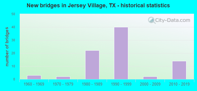
- New bridges - historical statistics
- 31960-1969
- 21970-1979
- 221980-1989
- 401990-1999
- 22000-2009
- 142010-2019

- Reconstructed bridges - Historical Statistics
- 31980-1989
- 01990-1999
- 62000-2009
- 102010-2019


- Bridge Condition - Deck
- 1.7%Very good
- 66.1%Good
- 30.5%Satisfactory
- 1.7%Fair

- Bridge Condition - Superstructure
- 16.9%Very good
- 52.5%Good
- 28.8%Satisfactory
- 1.7%Fair

- Bridge Condition - Substructure
- 8.5%Very good
- 69.5%Good
- 22.0%Satisfactory

- Bridge Condition - Channel
- 6.7%Very good
- 76.7%Good
- 13.3%Satisfactory
- 3.3%Fair
Find on map >> Show street view
Structure Number: 121020005008107, Location: 1.30 MI SE OF FM 1960 (Lat: 29.902147, Lng: -95.600939), Route carried "on" structure: US 290, Year Built: 1989, Year Reconstructed: 2018, Status: Open, Structure Length: 62.88m (206.30ft), Average Daily Traffic: 188,024 (year 2019), Truck Traffic: 10%, Average Future Daily Traffic: 256,824 (year 2033), Design Load: HS 20, Features Intersected: ELDRIDGE RD & WEST RD
Minimum Vertical Clearance: 30+ m (98+ ft), Kilometerpoint: 35.459, Lanes on structure: 9, Lanes under structure: 13, Owner: State Highway Agency, Approaching Roadway Width: 56.1m (184.1ft), Skew: 39 degrees, Material/Design: Prestressed concrete, Design/Construction: Stringer/Multi-beam, Number Of Spans In Main Unit: 2, Number Of Approach Spans: 22, Length of Maximum Span: 36.6m (120.1ft), Curb-To-Curb Width: 56.1m (184.1ft), Out-to-Out Width: 58.6m (192.3ft)
Condition: Deck: Satisfactory, Superstructure: Fair, Substructure: Satisfactory, Operating Rating: 54.4 metric tons, Method Used To Determine Operating Rating: Assigned rating based on Load Factor Design (LFD) reported in metric tons, Inventory Rating: 32.7 metric tons, Method Used To Determine Inventory Rating: Assigned rating based on Load Factor Design (LFD) reported in metric tons, Structural Evaluation: Somewhat better than minimum adequacy, Deck Geometry: Superior to present desirable criteria, Underclear: Somewhat better than minimum adequacy, Approach Roadway Alignment: Equal to present desirable criteria, Designated Inspection Frequency: Every 24 months, Inspection Date: October 2020, Deck Structure Type: Concrete Cast-file-Place
Find on map >> Show street view
Structure Number: 121020005008108, Location: 1.90 MI SE OF FM 1960 (Lat: 29.898400, Lng: -95.595447), Route carried "on" structure: US 290, Year Built: 1989, Year Reconstructed: 2018, Status: Open, Structure Length: 3.14m (10.30ft), Average Daily Traffic: 97,535 (year 2016), Truck Traffic: 10%, Average Future Daily Traffic: 112,790 (year 2033), Design Load: HS 20, Features Intersected: HCFCD Unit E135-00-00
Minimum Vertical Clearance: 30+ m (98+ ft), Kilometerpoint: 36.403, Lanes on structure: 6, Owner: State Highway Agency, Approaching Roadway Width: 29.0m (95.1ft), Skew: 1 degrees, Material/Design: Concrete, Design/Construction: Stringer/Multi-beam, Number Of Spans In Main Unit: 3, Length of Maximum Span: 12.5m (41.0ft), Curb-To-Curb Width: 29.1m (95.5ft), Out-to-Out Width: 29.8m (97.8ft)
Condition: Deck: Satisfactory, Superstructure: Satisfactory, Substructure: Good, Channel: Good, Operating Rating: 68.0 metric tons, Method Used To Determine Operating Rating: Load Factor (LF), Inventory Rating: 40.8 metric tons, Method Used To Determine Inventory Rating: Load Factor (LF), Structural Evaluation: Equal to present minimum criteria, Deck Geometry: Better than present minimum criteria, Waterway Adequacy: Superior to present desirable criteria, Approach Roadway Alignment: Equal to present desirable criteria, Designated Inspection Frequency: Every 24 months, Inspection Date: October 2020, Deck Structure Type: Concrete Cast-file-Place
Find on map >> Show street view
Structure Number: 121020005008109, Location: 2.70 MI SE OF FM 1960 (Lat: 29.890600, Lng: -95.584572), Route carried "on" structure: US 290, Year Built: 1989, Year Reconstructed: 2018, Status: Open, Structure Length: 21.73m (71.29ft), Average Daily Traffic: 188,024 (year 2019), Truck Traffic: 10%, Average Future Daily Traffic: 225,580 (year 2033), Design Load: HS 20, Features Intersected: JONES RD
Minimum Vertical Clearance: 30+ m (98+ ft), Kilometerpoint: 37.689, Lanes on structure: 11, Lanes under structure: 7, Owner: State Highway Agency, Approaching Roadway Width: 65.2m (213.9ft), Skew: 30 degrees, Material/Design: Prestressed concrete, Design/Construction: Stringer/Multi-beam, Number Of Spans In Main Unit: 1, Number Of Approach Spans: 7, Length of Maximum Span: 36.6m (120.1ft), Curb-To-Curb Width: 65.2m (213.9ft), Out-to-Out Width: 66.0m (216.5ft)
Condition: Deck: Satisfactory, Superstructure: Satisfactory, Substructure: Satisfactory, Operating Rating: 54.4 metric tons, Method Used To Determine Operating Rating: Assigned rating based on Load Factor Design (LFD) reported in metric tons, Inventory Rating: 32.7 metric tons, Method Used To Determine Inventory Rating: Assigned rating based on Load Factor Design (LFD) reported in metric tons, Structural Evaluation: Equal to present minimum criteria, Deck Geometry: Superior to present desirable criteria, Underclear: Meets minimum limits, Approach Roadway Alignment: Equal to present desirable criteria, Designated Inspection Frequency: Every 24 months, Inspection Date: October 2020, Deck Structure Type: Concrete Cast-file-Place
Find on map >> Show street view
Structure Number: 12102000500811, Location: 1.90 MI NW OF BWY 8 (Lat: 29.888075, Lng: -95.580981), Route carried "on" structure: US 290, Year Built: 1989, Year Reconstructed: 2018, Status: Open, Structure Length: 2.77m (9.09ft), Average Daily Traffic: 88,163 (year 2016), Truck Traffic: 10%, Average Future Daily Traffic: 225,580 (year 2033), Design Load: HS 20, Features Intersected: HCFCD Unit E127-00-00
Minimum Vertical Clearance: 30+ m (98+ ft), Kilometerpoint: 38.232, Lanes on structure: 11, Owner: State Highway Agency, Approaching Roadway Width: 63.2m (207.3ft), Skew: 30 degrees, Material/Design: Concrete, Design/Construction: Stringer/Multi-beam, Number Of Spans In Main Unit: 3, Length of Maximum Span: 9.1m (29.9ft), Curb-To-Curb Width: 63.2m (207.3ft), Out-to-Out Width: 66.6m (218.5ft)
Condition: Deck: Satisfactory, Superstructure: Satisfactory, Substructure: Good, Channel: Good, Operating Rating: 61.7 metric tons, Method Used To Determine Operating Rating: Load Factor (LF), Inventory Rating: 36.3 metric tons, Method Used To Determine Inventory Rating: Load Factor (LF), Structural Evaluation: Equal to present minimum criteria, Deck Geometry: Superior to present desirable criteria, Waterway Adequacy: Superior to present desirable criteria, Approach Roadway Alignment: Equal to present desirable criteria, Designated Inspection Frequency: Every 24 months, Inspection Date: October 2020, Deck Structure Type: Concrete Cast-file-Place
Find on map >> Show street view
Structure Number: 121020005008115, Location: 1.90 MI SE OF FM 1960 (Lat: 29.898228, Lng: -95.595864), Route carried "on" structure: US 290, Year Built: 1985, Year Reconstructed: 2016, Status: Open, Structure Length: 3.14m (10.30ft), Average Daily Traffic: 88,163 (year 2016), Truck Traffic: 10%, Average Future Daily Traffic: 112,790 (year 2033), Design Load: HS 20, Features Intersected: HCFCD Unit E135-00-00
Minimum Vertical Clearance: 30+ m (98+ ft), Kilometerpoint: 36.403, Lanes on structure: 6, Owner: State Highway Agency, Approaching Roadway Width: 26.5m (86.9ft), Skew: 1 degrees, Material/Design: Concrete, Design/Construction: Stringer/Multi-beam, Number Of Spans In Main Unit: 3, Length of Maximum Span: 12.5m (41.0ft), Curb-To-Curb Width: 26.7m (87.6ft), Out-to-Out Width: 27.3m (89.6ft)
Condition: Deck: Fair, Superstructure: Satisfactory, Substructure: Good, Channel: Good, Operating Rating: 68.0 metric tons, Method Used To Determine Operating Rating: Load Factor (LF), Inventory Rating: 40.8 metric tons, Method Used To Determine Inventory Rating: Load Factor (LF), Structural Evaluation: Equal to present minimum criteria, Deck Geometry: Somewhat better than minimum adequacy, Waterway Adequacy: Superior to present desirable criteria, Approach Roadway Alignment: Equal to present desirable criteria, Designated Inspection Frequency: Every 24 months, Inspection Date: October 2020, Deck Structure Type: Concrete Cast-file-Place
Find on map >> Show street view
Structure Number: 121020005008131, Location: 1.90 MI SE OF FM 1960 (Lat: 29.897631, Lng: -95.594625), Route carried "on" structure: Ramp US 290, Year Built: 1989, Status: Open, Structure Length: 32.40m (106.30ft), Average Daily Traffic: 16,110 (year 2013), Truck Traffic: 10%, Average Future Daily Traffic: 22,550 (year 2033), Design Load: HS 20, Features Intersected: US 290 WB
Minimum Vertical Clearance: 30+ m (98+ ft), Kilometerpoint: 36.276, Lanes on structure: 1, Lanes under structure: 3, Owner: State Highway Agency, Approaching Roadway Width: 6.1m (20.0ft), Material/Design: Prestressed concrete, Design/Construction: Box Beam or Girders - Multiple, Number Of Spans In Main Unit: 10, Number Of Approach Spans: 3, Length of Maximum Span: 27.4m (89.9ft), Curb-To-Curb Width: 6.0m (19.7ft), Out-to-Out Width: 6.9m (22.6ft)
Condition: Deck: Satisfactory, Superstructure: Good, Substructure: Satisfactory, Operating Rating: 54.4 metric tons, Method Used To Determine Operating Rating: Assigned rating based on Load Factor Design (LFD) reported in metric tons, Inventory Rating: 32.7 metric tons, Method Used To Determine Inventory Rating: Assigned rating based on Load Factor Design (LFD) reported in metric tons, Structural Evaluation: Equal to present minimum criteria, Deck Geometry: Meets minimum limits, Underclear: Meets minimum limits, Approach Roadway Alignment: Equal to present desirable criteria, Designated Inspection Frequency: Every 24 months, Inspection Date: October 2020, Deck Structure Type: Concrete Cast-file-Place
Find on map >> Show street view
Structure Number: 121020005008477, Location: 1.9 MI SE OF FM 1960 (Lat: 29.898097, Lng: -95.595978), Route carried "on" structure: ServiceUS 290, Year Built: 2014, Status: Open, Structure Length: 3.20m (10.50ft), Average Daily Traffic: 12,910 (year 2011), Truck Traffic: 3%, Average Future Daily Traffic: 18,070 (year 2031), Design Load: HL 93, Features Intersected: HCFCD DRAINAGE DITCH
Minimum Vertical Clearance: 30+ m (98+ ft), Kilometerpoint: 36.403, Lanes on structure: 2, Owner: State Highway Agency, Approaching Roadway Width: 7.3m (24.0ft), Skew: 1 degrees, Material/Design: Prestressed concrete, Number Of Spans In Main Unit: 3, Length of Maximum Span: 13.7m (44.9ft), Curb or Sidewalk Widths: Left: 0.0m, Right: 1.9m (6.2ft), Curb-To-Curb Width: 7.4m (24.3ft), Out-to-Out Width: 10.1m (33.1ft)
Condition: Deck: Good, Superstructure: Good, Substructure: Good, Channel: Good, Operating Rating: 54.4 metric tons, Method Used To Determine Operating Rating: Assigned ratings based on Load and Resistance Factor Design (LRFD) reported in metric tons, Inventory Rating: 32.7 metric tons, Method Used To Determine Inventory Rating: Assigned ratings based on Load and Resistance Factor Design (LRFD) reported in metric tons, Structural Evaluation: Better than present minimum criteria, Deck Geometry: High priority of replacement, Waterway Adequacy: Superior to present desirable criteria, Approach Roadway Alignment: Equal to present desirable criteria, Designated Inspection Frequency: Every 24 months, Inspection Date: December 2020, Deck Structure Type: Concrete Cast-file-Place
Find on map >> Show street view
Structure Number: 121020005008478, Location: 1.9 MI SE of FM 1960 (Lat: 29.898575, Lng: -95.595278), Route carried "on" structure: ServiceUS 290, Year Built: 2018, Status: Open, Structure Length: 3.84m (12.60ft), Average Daily Traffic: 5,380 (year 2015), Truck Traffic: 3%, Average Future Daily Traffic: 8,140 (year 2035), Design Load: HL 93, Features Intersected: HCFCD E-135-00-00
Minimum Vertical Clearance: 30+ m (98+ ft), Kilometerpoint: 36.403, Lanes on structure: 3, Owner: State Highway Agency, Approaching Roadway Width: 10.7m (35.1ft), Skew: 1 degrees, Material/Design: Prestressed concrete, Number Of Spans In Main Unit: 3, Length of Maximum Span: 13.7m (44.9ft), Curb or Sidewalk Widths: Left: 2.0m (6.6ft), Right: 0.0m, Curb-To-Curb Width: 10.7m (35.1ft), Out-to-Out Width: 13.4m (44.0ft)
Condition: Deck: Good, Superstructure: Very good, Substructure: Good, Channel: Good, Operating Rating: 54.4 metric tons, Method Used To Determine Operating Rating: Assigned ratings based on Load and Resistance Factor Design (LRFD) reported in metric tons, Inventory Rating: 32.7 metric tons, Method Used To Determine Inventory Rating: Assigned ratings based on Load and Resistance Factor Design (LRFD) reported in metric tons, Structural Evaluation: Better than present minimum criteria, Deck Geometry: High priority of replacement, Waterway Adequacy: Equal to present desirable criteria, Approach Roadway Alignment: Equal to present desirable criteria, Designated Inspection Frequency: Every 24 months, Inspection Date: October 2020, Deck Structure Type: Concrete Cast-file-Place
Find on map >> Show street view
Structure Number: 121020005008479, Location: 0.3 MI SE of Jones Rd. (Lat: 29.888228, Lng: -95.580617), Route carried "on" structure: ServiceUS 290, Year Built: 2018, Status: Open, Structure Length: 3.20m (10.50ft), Average Daily Traffic: 12,000 (year 2015), Truck Traffic: 3%, Average Future Daily Traffic: 15,740 (year 2035), Design Load: HL 93, Features Intersected: HCFCD E-127-00-00
Minimum Vertical Clearance: 30+ m (98+ ft), Kilometerpoint: 38.232, Lanes on structure: 2, Owner: State Highway Agency, Approaching Roadway Width: 7.3m (24.0ft), Material/Design: Prestressed concrete, Number Of Spans In Main Unit: 1, Number Of Approach Spans: 2, Length of Maximum Span: 13.7m (44.9ft), Curb or Sidewalk Widths: Left: 2.0m (6.6ft), Right: 0.0m, Curb-To-Curb Width: 7.3m (24.0ft), Out-to-Out Width: 10.1m (33.1ft)
Condition: Deck: Good, Superstructure: Very good, Substructure: Good, Channel: Very good, Operating Rating: 54.4 metric tons, Method Used To Determine Operating Rating: Assigned ratings based on Load and Resistance Factor Design (LRFD) reported in metric tons, Inventory Rating: 32.7 metric tons, Method Used To Determine Inventory Rating: Assigned ratings based on Load and Resistance Factor Design (LRFD) reported in metric tons, Structural Evaluation: Better than present minimum criteria, Deck Geometry: High priority of replacement, Waterway Adequacy: Superior to present desirable criteria, Approach Roadway Alignment: Equal to present desirable criteria, Designated Inspection Frequency: Every 24 months, Inspection Date: October 2020, Deck Structure Type: Concrete Cast-file-Place
Find on map >> Show street view
Structure Number: 12102000500848, Location: 0.3 MI SE OF JOINES RD (Lat: 29.887800, Lng: -95.581422), Route carried "on" structure: ServiceUS 290, Year Built: 2014, Status: Open, Structure Length: 3.20m (10.50ft), Average Daily Traffic: 12,910 (year 2011), Truck Traffic: 3%, Average Future Daily Traffic: 18,070 (year 2031), Design Load: HL 93, Features Intersected: DRAINAGE DITCH
Minimum Vertical Clearance: 30+ m (98+ ft), Kilometerpoint: 38.232, Lanes on structure: 2, Owner: State Highway Agency, Approaching Roadway Width: 7.3m (24.0ft), Material/Design: Prestressed concrete, Number Of Spans In Main Unit: 3, Length of Maximum Span: 13.7m (44.9ft), Curb or Sidewalk Widths: Left: 0.0m, Right: 2.0m (6.6ft), Curb-To-Curb Width: 7.3m (24.0ft), Out-to-Out Width: 10.1m (33.1ft)
Condition: Deck: Good, Superstructure: Very good, Substructure: Good, Channel: Good, Operating Rating: 54.4 metric tons, Method Used To Determine Operating Rating: Assigned ratings based on Load and Resistance Factor Design (LRFD) reported in metric tons, Inventory Rating: 32.7 metric tons, Method Used To Determine Inventory Rating: Assigned ratings based on Load and Resistance Factor Design (LRFD) reported in metric tons, Structural Evaluation: Better than present minimum criteria, Deck Geometry: High priority of replacement, Waterway Adequacy: Superior to present desirable criteria, Approach Roadway Alignment: Equal to present desirable criteria, Designated Inspection Frequency: Every 24 months, Inspection Date: December 2020, Deck Structure Type: Concrete Cast-file-Place
Find on map >> Show street view
Structure Number: 121020005008525, Location: 1.90 MI SE OF FM 1960 (Lat: 29.899192, Lng: -95.595736), Route carried "on" structure: Ramp US 290, Year Built: 2018, Status: Open, Structure Length: 4.57m (14.99ft), Average Daily Traffic: 16,110 (year 2013), Truck Traffic: 1%, Average Future Daily Traffic: 22,550 (year 2033), Design Load: HL 93, Features Intersected: US 290 WB FR AT WEST RD
Minimum Vertical Clearance: 6.02m (19.75ft), Kilometerpoint: 36.357, Lanes on structure: 1, Lanes under structure: 3, Base Highway Network: Yes, Owner: State Highway Agency, Approaching Roadway Width: 6.1m (20.0ft), Material/Design: Steel continuous, Design/Construction: Stringer/Multi-beam, Number Of Spans In Main Unit: 1, Number Of Approach Spans: 2, Length of Maximum Span: 21.0m (68.9ft), Curb-To-Curb Width: 6.2m (20.3ft), Out-to-Out Width: 7.1m (23.3ft)
Condition: Deck: Very good, Superstructure: Very good, Substructure: Good, Operating Rating: 54.4 metric tons, Method Used To Determine Operating Rating: Assigned ratings based on Load and Resistance Factor Design (LRFD) reported in metric tons, Inventory Rating: 32.7 metric tons, Method Used To Determine Inventory Rating: Assigned ratings based on Load and Resistance Factor Design (LRFD) reported in metric tons, Structural Evaluation: Better than present minimum criteria, Deck Geometry: Somewhat better than minimum adequacy, Underclear: Superior to present desirable criteria, Approach Roadway Alignment: Equal to present desirable criteria, Designated Inspection Frequency: Every 24 months, Inspection Date: October 2020, Deck Structure Type: Concrete Cast-file-Place
Find on map >> Show street view
Structure Number: 121020005009116, Location: 0.70 MI NW OF BWY 8 (Lat: 29.879450, Lng: -95.568539), Route carried "on" structure: Alternate US 290, Year Built: 1989, Year Reconstructed: 2016, Status: Open, Structure Length: 25.18m (82.61ft), Average Daily Traffic: 46,500 (year 2014), Truck Traffic: 6%, Average Future Daily Traffic: 87,780 (year 2034), Design Load: HS 20, Features Intersected: FM 529
Minimum Vertical Clearance: 30+ m (98+ ft), Kilometerpoint: 46.708, Lanes on structure: 6, Lanes under structure: 6, Owner: State Highway Agency, Approaching Roadway Width: 29.0m (95.1ft), Skew: 15 degrees, Material/Design: Prestressed concrete, Design/Construction: Stringer/Multi-beam, Number Of Spans In Main Unit: 1, Number Of Approach Spans: 7, Length of Maximum Span: 49.7m (163.1ft), Curb-To-Curb Width: 28.9m (94.8ft), Out-to-Out Width: 33.2m (108.9ft)
Condition: Deck: Satisfactory, Superstructure: Satisfactory, Substructure: Satisfactory, Operating Rating: 54.4 metric tons, Method Used To Determine Operating Rating: Assigned rating based on Load Factor Design (LFD) reported in metric tons, Inventory Rating: 32.7 metric tons, Method Used To Determine Inventory Rating: Assigned rating based on Load Factor Design (LFD) reported in metric tons, Structural Evaluation: Equal to present minimum criteria, Deck Geometry: Better than present minimum criteria, Underclear: Meets minimum limits, Approach Roadway Alignment: Equal to present desirable criteria, Designated Inspection Frequency: Every 24 months, Inspection Date: October 2020, Deck Structure Type: Concrete Cast-file-Place
Find on map >> Show street view
Structure Number: 121020005009117, Location: 0.40 MI W OF BWY 8 (Lat: 29.876767, Lng: -95.563111), Route carried "on" structure: US 290, Year Built: 1990, Year Reconstructed: 2016, Status: Open, Structure Length: 10.21m (33.50ft), Average Daily Traffic: 88,163 (year 2016), Truck Traffic: 10%, Average Future Daily Traffic: 112,790 (year 2033), Design Load: HS 20, Features Intersected: SENATE DRIVE
Minimum Vertical Clearance: 30+ m (98+ ft), Kilometerpoint: 47.683, Lanes on structure: 5, Lanes under structure: 8, Owner: State Highway Agency, Approaching Roadway Width: 28.3m (92.8ft), Skew: 30 degrees, Material/Design: Prestressed concrete, Design/Construction: Stringer/Multi-beam, Number Of Spans In Main Unit: 3, Length of Maximum Span: 35.1m (115.2ft), Curb-To-Curb Width: 29.2m (95.8ft), Out-to-Out Width: 29.5m (96.8ft)
Condition: Deck: Satisfactory, Superstructure: Good, Substructure: Good, Operating Rating: 54.4 metric tons, Method Used To Determine Operating Rating: Assigned rating based on Load Factor Design (LFD) reported in metric tons, Inventory Rating: 32.7 metric tons, Method Used To Determine Inventory Rating: Assigned rating based on Load Factor Design (LFD) reported in metric tons, Structural Evaluation: Better than present minimum criteria, Deck Geometry: Superior to present desirable criteria, Underclear: Superior to present desirable criteria, Approach Roadway Alignment: Equal to present desirable criteria, Designated Inspection Frequency: Every 24 months, Inspection Date: October 2020, Deck Structure Type: Concrete Cast-file-Place
Find on map >> Show street view
Structure Number: 121020005009118, Location: US 290 AT BELTWAY 8 (Lat: 29.873292, Lng: -95.555261), Route carried "on" structure: US 290, Year Built: 1990, Status: Open, Structure Length: 23.47m (77.00ft), Average Daily Traffic: 88,163 (year 2016), Truck Traffic: 8%, Average Future Daily Traffic: 112,790 (year 2033), Design Load: HS 20, Features Intersected: BW 8 Frontage Roads
Minimum Vertical Clearance: 5.89m (19.32ft), Kilometerpoint: 48.280, Lanes on structure: 4, Lanes under structure: 6, Owner: State Highway Agency, Approaching Roadway Width: 20.7m (67.9ft), Skew: 3 degrees, Material/Design: Prestressed concrete, Design/Construction: Stringer/Multi-beam, Number Of Spans In Main Unit: 6, Number Of Approach Spans: 1, Length of Maximum Span: 39.6m (129.9ft), Curb-To-Curb Width: 21.0m (68.9ft), Out-to-Out Width: 21.6m (70.9ft)
Condition: Deck: Satisfactory, Superstructure: Good, Substructure: Good, Operating Rating: 54.4 metric tons, Method Used To Determine Operating Rating: Assigned rating based on Load Factor Design (LFD) reported in metric tons, Inventory Rating: 32.7 metric tons, Method Used To Determine Inventory Rating: Assigned rating based on Load Factor Design (LFD) reported in metric tons, Structural Evaluation: Better than present minimum criteria, Deck Geometry: Better than present minimum criteria, Underclear: High priority of corrective action, Approach Roadway Alignment: Equal to present desirable criteria, Designated Inspection Frequency: Every 24 months, Inspection Date: October 2020, Deck Structure Type: Concrete Cast-file-Place
Find on map >> Show street view
Structure Number: 121020005009119, Location: US 290 AT BELTWAY 8 (Lat: 29.873408, Lng: -95.555089), Route carried "on" structure: US 290, Year Built: 1990, Status: Open, Structure Length: 23.47m (77.00ft), Average Daily Traffic: 97,535 (year 2016), Truck Traffic: 8%, Average Future Daily Traffic: 112,790 (year 2033), Design Load: HS 20, Features Intersected: BW 8 Frontage Roads
Minimum Vertical Clearance: 5.31m (17.42ft), Kilometerpoint: 48.280, Lanes on structure: 4, Lanes under structure: 6, Owner: State Highway Agency, Approaching Roadway Width: 20.7m (67.9ft), Skew: 3 degrees, Material/Design: Prestressed concrete, Design/Construction: Stringer/Multi-beam, Number Of Spans In Main Unit: 6, Number Of Approach Spans: 1, Length of Maximum Span: 39.6m (129.9ft), Curb-To-Curb Width: 21.0m (68.9ft), Out-to-Out Width: 21.6m (70.9ft)
Condition: Deck: Satisfactory, Superstructure: Satisfactory, Substructure: Good, Operating Rating: 54.4 metric tons, Method Used To Determine Operating Rating: Assigned rating based on Load Factor Design (LFD) reported in metric tons, Inventory Rating: 32.7 metric tons, Method Used To Determine Inventory Rating: Assigned rating based on Load Factor Design (LFD) reported in metric tons, Structural Evaluation: Equal to present minimum criteria, Deck Geometry: Better than present minimum criteria, Underclear: High priority of corrective action, Approach Roadway Alignment: Equal to present desirable criteria, Designated Inspection Frequency: Every 24 months, Inspection Date: October 2020, Deck Structure Type: Concrete Cast-file-Place
Find on map >> Show street view
Structure Number: 12102000500912, Location: US 290 AT BELTWAY 8 (Lat: 29.872444, Lng: -95.553128), Route carried "on" structure: Ramp US 290, Year Built: 1990, Status: Open, Structure Length: 23.47m (77.00ft), Average Daily Traffic: 14,750 (year 2019), Truck Traffic: 8%, Average Future Daily Traffic: 22,550 (year 2033), Design Load: HS 20, Features Intersected: BW 8 Frontage Roads
Minimum Vertical Clearance: 5.28m (17.32ft), Kilometerpoint: 47.138, Lanes on structure: 1, Lanes under structure: 10, Owner: State Highway Agency, Approaching Roadway Width: 6.1m (20.0ft), Skew: 3 degrees, Material/Design: Prestressed concrete, Design/Construction: Stringer/Multi-beam, Number Of Spans In Main Unit: 7, Length of Maximum Span: 39.6m (129.9ft), Curb-To-Curb Width: 6.0m (19.7ft), Out-to-Out Width: 6.9m (22.6ft)
Condition: Deck: Good, Superstructure: Satisfactory, Substructure: Good, Operating Rating: 54.4 metric tons, Method Used To Determine Operating Rating: Assigned rating based on Load Factor Design (LFD) reported in metric tons, Inventory Rating: 32.7 metric tons, Method Used To Determine Inventory Rating: Assigned rating based on Load Factor Design (LFD) reported in metric tons, Structural Evaluation: Equal to present minimum criteria, Deck Geometry: Meets minimum limits, Underclear: High priority of corrective action, Approach Roadway Alignment: Equal to present desirable criteria, Designated Inspection Frequency: Every 24 months, Inspection Date: October 2020, Deck Structure Type: Concrete Cast-file-Place
Find on map >> Show street view
Structure Number: 121020005009147, Location: 0.35 MI SE OF BW 8 (Lat: 29.871394, Lng: -95.551061), Route carried "on" structure: Ramp US 290, Year Built: 1988, Status: Open, Structure Length: 11.34m (37.20ft), Average Daily Traffic: 79,000 (year 2016), Truck Traffic: 8%, Average Future Daily Traffic: 146,300 (year 2036), Design Load: HS 20, Features Intersected: US 290 EBFR & Coll-Dist
Minimum Vertical Clearance: 30+ m (98+ ft), Kilometerpoint: 49.182, Lanes on structure: 2, Lanes under structure: 6, Owner: State Highway Agency, Approaching Roadway Width: 9.1m (29.9ft), Material/Design: Steel, Design/Construction: Stringer/Multi-beam, Number Of Spans In Main Unit: 1, Number Of Approach Spans: 3, Length of Maximum Span: 31.1m (102.0ft), Curb-To-Curb Width: 9.1m (29.9ft), Out-to-Out Width: 10.0m (32.8ft)
Condition: Deck: Satisfactory, Superstructure: Good, Substructure: Satisfactory, Operating Rating: 54.4 metric tons, Method Used To Determine Operating Rating: Assigned rating based on Load Factor Design (LFD) reported in metric tons, Inventory Rating: 32.7 metric tons, Method Used To Determine Inventory Rating: Assigned rating based on Load Factor Design (LFD) reported in metric tons, Structural Evaluation: Equal to present minimum criteria, Deck Geometry: Meets minimum limits, Underclear: High priority of corrective action, Approach Roadway Alignment: Equal to present desirable criteria, Designated Inspection Frequency: Every 24 months, Inspection Date: October 2020, Deck Structure Type: Concrete Cast-file-Place
Find on map >> Show street view
Structure Number: 121020005009151, Location: 0.60 MI NW OF BWY 8 (Lat: 29.876936, Lng: -95.563019), Route carried "on" structure: US 290, Year Built: 1990, Year Reconstructed: 2016, Status: Open, Structure Length: 10.21m (33.50ft), Average Daily Traffic: 97,535 (year 2016), Truck Traffic: 8%, Average Future Daily Traffic: 112,790 (year 2033), Design Load: HS 20, Features Intersected: SENATE DRIVE
Minimum Vertical Clearance: 30+ m (98+ ft), Kilometerpoint: 47.616, Lanes on structure: 6, Lanes under structure: 8, Owner: State Highway Agency, Approaching Roadway Width: 25.0m (82.0ft), Skew: 30 degrees, Material/Design: Prestressed concrete, Design/Construction: Stringer/Multi-beam, Number Of Spans In Main Unit: 3, Length of Maximum Span: 35.1m (115.2ft), Curb-To-Curb Width: 33.5m (109.9ft), Out-to-Out Width: 37.9m (124.3ft)
Condition: Deck: Good, Superstructure: Good, Substructure: Good, Operating Rating: 54.4 metric tons, Method Used To Determine Operating Rating: Assigned rating based on Load Factor Design (LFD) reported in metric tons, Inventory Rating: 32.7 metric tons, Method Used To Determine Inventory Rating: Assigned rating based on Load Factor Design (LFD) reported in metric tons, Structural Evaluation: Better than present minimum criteria, Deck Geometry: Superior to present desirable criteria, Underclear: Equal to present minimum criteria, Approach Roadway Alignment: Equal to present desirable criteria, Designated Inspection Frequency: Every 24 months, Inspection Date: October 2020, Deck Structure Type: Concrete Cast-file-Place
Find on map >> Show street view
Structure Number: 121020005009152, Location: 0.70 MI NW OF BWY 8 (Lat: 29.879439, Lng: -95.568886), Route carried "on" structure: US 290, Year Built: 1990, Year Reconstructed: 2016, Status: Open, Structure Length: 25.18m (82.61ft), Average Daily Traffic: 88,163 (year 2016), Truck Traffic: 10%, Average Future Daily Traffic: 112,790 (year 2033), Design Load: HS 20, Features Intersected: FM 529
Minimum Vertical Clearance: 30+ m (98+ ft), Kilometerpoint: 46.708, Lanes on structure: 6, Lanes under structure: 6, Owner: State Highway Agency, Approaching Roadway Width: 29.0m (95.1ft), Skew: 15 degrees, Material/Design: Prestressed concrete, Design/Construction: Stringer/Multi-beam, Number Of Spans In Main Unit: 4, Number Of Approach Spans: 5, Length of Maximum Span: 36.3m (119.1ft), Curb-To-Curb Width: 28.8m (94.5ft), Out-to-Out Width: 33.0m (108.3ft)
Condition: Deck: Satisfactory, Superstructure: Good, Substructure: Satisfactory, Operating Rating: 54.4 metric tons, Method Used To Determine Operating Rating: Assigned rating based on Load Factor Design (LFD) reported in metric tons, Inventory Rating: 32.7 metric tons, Method Used To Determine Inventory Rating: Assigned rating based on Load Factor Design (LFD) reported in metric tons, Structural Evaluation: Equal to present minimum criteria, Deck Geometry: Better than present minimum criteria, Underclear: Better than present minimum criteria, Approach Roadway Alignment: Equal to present desirable criteria, Designated Inspection Frequency: Every 24 months, Inspection Date: October 2020, Deck Structure Type: Concrete Cast-file-Place
Find on map >> Show street view
Structure Number: 12102000500916, Location: US 290 AT BELTWAY 8 (Lat: 29.872167, Lng: -95.558225), Route carried "on" structure: Ramp State highway 8, Year Built: 1990, Status: Open, Structure Length: 105.77m (347.01ft), Average Daily Traffic: 3,000 (year 2016), Truck Traffic: 4%, Average Future Daily Traffic: 24,200 (year 2036), Design Load: HS 20, Features Intersected: US 290 EBFR & BW 8 NBFR
Minimum Vertical Clearance: 6.10m (20.01ft), Kilometerpoint: 28.683, Lanes on structure: 1, Lanes under structure: 10, Owner: Local Toll Authority, Approaching Roadway Width: 7.3m (24.0ft), Material/Design: Prestressed concrete, Design/Construction: Stringer/Multi-beam, Number Of Spans In Main Unit: 31, Number Of Approach Spans: 2, Length of Maximum Span: 36.3m (119.1ft), Curb-To-Curb Width: 7.6m (24.9ft), Out-to-Out Width: 8.2m (26.9ft)
Condition: Deck: Good, Superstructure: Good, Substructure: Good, Operating Rating: 54.4 metric tons, Method Used To Determine Operating Rating: Assigned rating based on Load Factor Design (LFD) reported in metric tons, Inventory Rating: 32.7 metric tons, Method Used To Determine Inventory Rating: Assigned rating based on Load Factor Design (LFD) reported in metric tons, Structural Evaluation: Better than present minimum criteria, Deck Geometry: Better than present minimum criteria, Underclear: High priority of corrective action, Approach Roadway Alignment: Equal to present desirable criteria, Designated Inspection Frequency: Every 24 months, Critical Feature Inspection Frequency: Every 24 months, Inspection Date: October 2020, Critical Feature Inspection Date: March 2021, Deck Structure Type: Concrete Cast-file-Place
Find on map >> Show street view
Structure Number: 121020005009161, Location: US 290 AT BELTWAY 8 (Lat: 29.873342, Lng: -95.552603), Route carried "on" structure: Ramp US 290, Year Built: 1990, Status: Open, Structure Length: 26.24m (86.09ft), Average Daily Traffic: 16,110 (year 2013), Truck Traffic: 8%, Average Future Daily Traffic: 22,550 (year 2033), Design Load: HS 20, Features Intersected: US 290 WB FR & BW8 NB FR
Minimum Vertical Clearance: 30+ m (98+ ft), Kilometerpoint: 47.200, Lanes on structure: 1, Lanes under structure: 6, Owner: Local Toll Authority, Approaching Roadway Width: 7.9m (25.9ft), Material/Design: Prestressed concrete, Design/Construction: Stringer/Multi-beam, Number Of Spans In Main Unit: 10, Number Of Approach Spans: 1, Length of Maximum Span: 24.7m (81.0ft), Curb-To-Curb Width: 8.4m (27.6ft), Out-to-Out Width: 9.0m (29.5ft)
Condition: Deck: Satisfactory, Superstructure: Good, Substructure: Satisfactory, Operating Rating: 54.4 metric tons, Method Used To Determine Operating Rating: Assigned rating based on Load Factor Design (LFD) reported in metric tons, Inventory Rating: 32.7 metric tons, Method Used To Determine Inventory Rating: Assigned rating based on Load Factor Design (LFD) reported in metric tons, Structural Evaluation: Equal to present minimum criteria, Deck Geometry: Superior to present desirable criteria, Underclear: High priority of corrective action, Approach Roadway Alignment: Equal to present desirable criteria, Designated Inspection Frequency: Every 24 months, Inspection Date: October 2020, Deck Structure Type: Concrete Cast-file-Place
Find on map >> Show street view
Structure Number: 121020005009162, Location: US 290 AT BELTWAY 8 (Lat: 29.874000, Lng: -95.554925), Route carried "on" structure: Other road 8, Year Built: 1990, Status: Open, Structure Length: 165.02m (541.40ft), Average Daily Traffic: 31,000 (year 2011), Truck Traffic: 4%, Average Future Daily Traffic: 50,000 (year 2029), Design Load: HS 20, Features Intersected: US 290
Minimum Vertical Clearance: 5.36m (17.59ft), Kilometerpoint: 28.683, Lanes on structure: 3, Lanes under structure: 29, Toll: On toll road, Owner: Local Toll Authority, Approaching Roadway Width: 17.1m (56.1ft), Skew: 9 degrees, Material/Design: Prestressed concrete, Design/Construction: Stringer/Multi-beam, Number Of Spans In Main Unit: 40, Number Of Approach Spans: 14, Length of Maximum Span: 36.6m (120.1ft), Curb-To-Curb Width: 17.2m (56.4ft), Out-to-Out Width: 18.0m (59.1ft)
Condition: Deck: Good, Superstructure: Good, Substructure: Good, Operating Rating: 54.4 metric tons, Method Used To Determine Operating Rating: Assigned rating based on Load Factor Design (LFD) reported in metric tons, Inventory Rating: 32.7 metric tons, Method Used To Determine Inventory Rating: Assigned rating based on Load Factor Design (LFD) reported in metric tons, Structural Evaluation: Better than present minimum criteria, Deck Geometry: Better than present minimum criteria, Underclear: Meets minimum limits, Approach Roadway Alignment: Equal to present desirable criteria, Designated Inspection Frequency: Every 24 months, Inspection Date: October 2020, Deck Structure Type: Concrete Cast-file-Place
Find on map >> Show street view
Structure Number: 121020005009163, Location: US 290 AT BELTWAY 8 (Lat: 29.873867, Lng: -95.554769), Route carried "on" structure: Other road 8, Year Built: 1990, Status: Open, Structure Length: 165.02m (541.40ft), Average Daily Traffic: 216,828 (year 2015), Truck Traffic: 4%, Average Future Daily Traffic: 346,925 (year 2035), Design Load: HS 20, Features Intersected: US 290
Minimum Vertical Clearance: 5.39m (17.68ft), Kilometerpoint: 28.683, Lanes on structure: 3, Lanes under structure: 29, Toll: On toll road, Owner: Local Toll Authority, Approaching Roadway Width: 17.1m (56.1ft), Skew: 9 degrees, Material/Design: Prestressed concrete, Design/Construction: Stringer/Multi-beam, Number Of Spans In Main Unit: 40, Number Of Approach Spans: 14, Length of Maximum Span: 36.6m (120.1ft), Curb-To-Curb Width: 17.2m (56.4ft), Out-to-Out Width: 18.0m (59.1ft)
Condition: Deck: Good, Superstructure: Good, Substructure: Good, Operating Rating: 54.4 metric tons, Method Used To Determine Operating Rating: Assigned rating based on Load Factor Design (LFD) reported in metric tons, Inventory Rating: 32.7 metric tons, Method Used To Determine Inventory Rating: Assigned rating based on Load Factor Design (LFD) reported in metric tons, Structural Evaluation: Better than present minimum criteria, Deck Geometry: Better than present minimum criteria, Underclear: Meets minimum limits, Approach Roadway Alignment: Equal to present desirable criteria, Designated Inspection Frequency: Every 24 months, Inspection Date: October 2020, Deck Structure Type: Concrete Cast-file-Place
Find on map >> Show street view
Structure Number: 121020005009164, Location: US 290 AT BELTWAY 8 (Lat: 29.874967, Lng: -95.559769), Route carried "on" structure: Other road 8, Year Built: 1990, Status: Open, Structure Length: 24.02m (78.81ft), Average Daily Traffic: 5,000 (year 2016), Truck Traffic: 4%, Average Future Daily Traffic: 7,000 (year 2036), Design Load: HS 20, Features Intersected: US 290 EBFR & BW 8 SBFR
Minimum Vertical Clearance: 30+ m (98+ ft), Kilometerpoint: 48.382, Lanes on structure: 1, Lanes under structure: 5, Toll: On toll road, Owner: Local Toll Authority, Approaching Roadway Width: 12.2m (40.0ft), Material/Design: Prestressed concrete, Design/Construction: Stringer/Multi-beam, Number Of Spans In Main Unit: 9, Length of Maximum Span: 27.1m (88.9ft), Curb-To-Curb Width: 11.8m (38.7ft), Out-to-Out Width: 12.6m (41.3ft)
Condition: Deck: Good, Superstructure: Good, Substructure: Good, Operating Rating: 54.4 metric tons, Method Used To Determine Operating Rating: Assigned rating based on Load Factor Design (LFD) reported in metric tons, Inventory Rating: 32.7 metric tons, Method Used To Determine Inventory Rating: Assigned rating based on Load Factor Design (LFD) reported in metric tons, Structural Evaluation: Better than present minimum criteria, Deck Geometry: Somewhat better than minimum adequacy, Underclear: High priority of corrective action, Approach Roadway Alignment: Equal to present desirable criteria, Designated Inspection Frequency: Every 24 months, Inspection Date: October 2020, Deck Structure Type: Concrete Cast-file-Place
Find on map >> Show street view
Structure Number: 121020005009176, Location: US 290 AT BELTWAY 8 (Lat: 29.874786, Lng: -95.553656), Route carried "on" structure: Other road 8, Year Built: 1990, Status: Open, Structure Length: 103.27m (338.81ft), Average Daily Traffic: 14,300 (year 2016), Truck Traffic: 4%, Average Future Daily Traffic: 24,200 (year 2036), Design Load: HS 20, Features Intersected: US 290 WBFR & BW 8 SBFR
Minimum Vertical Clearance: 30+ m (98+ ft), Kilometerpoint: 28.683, Lanes on structure: 1, Lanes under structure: 7, Toll: On toll road, Owner: Local Toll Authority, Approaching Roadway Width: 7.3m (24.0ft), Material/Design: Steel continuous, Design/Construction: Stringer/Multi-beam, Number Of Spans In Main Unit: 5, Number Of Approach Spans: 22, Length of Maximum Span: 75.9m (249.0ft), Curb-To-Curb Width: 7.9m (25.9ft), Out-to-Out Width: 8.5m (27.9ft)
Condition: Deck: Good, Superstructure: Satisfactory, Substructure: Satisfactory, Operating Rating: 54.4 metric tons, Method Used To Determine Operating Rating: Assigned rating based on Load Factor Design (LFD) reported in metric tons, Inventory Rating: 32.7 metric tons, Method Used To Determine Inventory Rating: Assigned rating based on Load Factor Design (LFD) reported in metric tons, Structural Evaluation: Equal to present minimum criteria, Deck Geometry: High priority of corrective action, Underclear: High priority of corrective action, Approach Roadway Alignment: Equal to present desirable criteria, Designated Inspection Frequency: Every 24 months, Critical Feature Inspection Frequency: Every 24 months, Inspection Date: October 2020, Critical Feature Inspection Date: January 2021, Deck Structure Type: Concrete Cast-file-Place
Find on map >> Show street view
Structure Number: 121020005009177, Location: US 290 AT BELTWAY 8 (Lat: 29.872386, Lng: -95.552253), Route carried "on" structure: Ramp US 290, Year Built: 1990, Year Reconstructed: 2016, Status: Open, Structure Length: 114.12m (374.41ft), Average Daily Traffic: 16,110 (year 2013), Truck Traffic: 8%, Average Future Daily Traffic: 22,550 (year 2033), Design Load: HS 20, Features Intersected: US 290 AND BW 8
Minimum Vertical Clearance: 30+ m (98+ ft), Kilometerpoint: 47.202, Lanes on structure: 1, Lanes under structure: 12, Base Highway Network: Yes, Owner: Local Toll Authority, Approaching Roadway Width: 11.0m (36.1ft), Material/Design: Steel continuous, Design/Construction: Stringer/Multi-beam, Number Of Spans In Main Unit: 8, Number Of Approach Spans: 21, Length of Maximum Span: 67.7m (222.1ft), Curb-To-Curb Width: 7.9m (25.9ft), Out-to-Out Width: 8.5m (27.9ft)
Condition: Deck: Good, Superstructure: Good, Substructure: Good, Operating Rating: 54.4 metric tons, Method Used To Determine Operating Rating: Assigned rating based on Load Factor Design (LFD) reported in metric tons, Inventory Rating: 32.7 metric tons, Method Used To Determine Inventory Rating: Assigned rating based on Load Factor Design (LFD) reported in metric tons, Structural Evaluation: Better than present minimum criteria, Deck Geometry: Equal to present desirable criteria, Underclear: Meets minimum limits, Approach Roadway Alignment: Equal to present desirable criteria, Length Of Structure Improvement: 114.12m (374.41ft), Designated Inspection Frequency: Every 24 months, Critical Feature Inspection Frequency: Every 24 months, Inspection Date: October 2020, Critical Feature Inspection Date: January 2021, Bridge Improvement Cost: $195,000, Roadway Improvement Cost: $49,000, Total Project Cost: $244,000, Deck Structure Type: Concrete Cast-file-Place
Find on map >> Show street view
Structure Number: 121020005009178, Location: US 290 AT BELTWAY 8 (Lat: 29.874236, Lng: -95.557878), Route carried "on" structure: Ramp US 290, Year Built: 1990, Status: Open, Structure Length: 126.22m (414.11ft), Average Daily Traffic: 16,500 (year 2011), Truck Traffic: 4%, Average Future Daily Traffic: 20,000 (year 2029), Design Load: HS 20, Features Intersected: US 290 AND BW 8
Minimum Vertical Clearance: 30+ m (98+ ft), Kilometerpoint: 48.382, Lanes on structure: 1, Lanes under structure: 18, Owner: Local Toll Authority, Approaching Roadway Width: 7.9m (25.9ft), Material/Design: Steel continuous, Design/Construction: Stringer/Multi-beam, Number Of Spans In Main Unit: 5, Number Of Approach Spans: 28, Length of Maximum Span: 74.1m (243.1ft), Curb-To-Curb Width: 7.9m (25.9ft), Out-to-Out Width: 8.5m (27.9ft)
Condition: Deck: Satisfactory, Superstructure: Good, Substructure: Good, Operating Rating: 54.4 metric tons, Method Used To Determine Operating Rating: Assigned rating based on Load Factor Design (LFD) reported in metric tons, Inventory Rating: 32.7 metric tons, Method Used To Determine Inventory Rating: Assigned rating based on Load Factor Design (LFD) reported in metric tons, Structural Evaluation: Better than present minimum criteria, Deck Geometry: Equal to present desirable criteria, Underclear: Meets minimum limits, Approach Roadway Alignment: Equal to present desirable criteria, Designated Inspection Frequency: Every 24 months, Critical Feature Inspection Frequency: Every 24 months, Inspection Date: October 2020, Critical Feature Inspection Date: January 2021, Deck Structure Type: Concrete Cast-file-Place
Find on map >> Show street view
Structure Number: 121020005009179, Location: US 290 AT BELTWAY 8 (Lat: 29.873336, Lng: -95.554147), Route carried "on" structure: Other road 8, Year Built: 1990, Status: Open, Structure Length: 29.44m (96.59ft), Average Daily Traffic: 9,400 (year 2016), Truck Traffic: 4%, Average Future Daily Traffic: 24,000 (year 2036), Design Load: HS 20, Features Intersected: US 290 ML & BW 8 ML
Minimum Vertical Clearance: 5.28m (17.32ft), Kilometerpoint: 28.683, Lanes on structure: 1, Lanes under structure: 21, Toll: On toll road, Owner: Local Toll Authority, Approaching Roadway Width: 8.5m (27.9ft), Material/Design: Steel continuous, Design/Construction: Stringer/Multi-beam, Number Of Spans In Main Unit: 5, Length of Maximum Span: 68.0m (223.1ft), Curb-To-Curb Width: 9.6m (31.5ft), Out-to-Out Width: 10.2m (33.5ft)
Condition: Deck: Good, Superstructure: Good, Substructure: Good, Operating Rating: 44.4 metric tons, Method Used To Determine Operating Rating: Assigned rating based on Load Factor Design (LFD) reported in metric tons, Inventory Rating: 32.7 metric tons, Method Used To Determine Inventory Rating: Assigned rating based on Load Factor Design (LFD) reported in metric tons, Structural Evaluation: Better than present minimum criteria, Deck Geometry: Meets minimum limits, Underclear: Meets minimum limits, Approach Roadway Alignment: Equal to present desirable criteria, Designated Inspection Frequency: Every 24 months, Critical Feature Inspection Frequency: Every 24 months, Inspection Date: October 2020, Critical Feature Inspection Date: May 2021, Deck Structure Type: Concrete Cast-file-Place
Find on map >> Show street view
Structure Number: 12102000500918, Location: US 290 AT BELTWAY 8 (Lat: 29.873536, Lng: -95.557558), Route carried "on" structure: Other road 8, Year Built: 1990, Status: Open, Structure Length: 33.28m (109.19ft), Average Daily Traffic: 7,500 (year 2016), Truck Traffic: 4%, Average Future Daily Traffic: 24,000 (year 2036), Design Load: HS 20, Features Intersected: US 290 ML & BW 8 ML
Minimum Vertical Clearance: 5.23m (17.16ft), Kilometerpoint: 28.683, Lanes on structure: 2, Lanes under structure: 19, Toll: On toll road, Owner: Local Toll Authority, Approaching Roadway Width: 11.0m (36.1ft), Material/Design: Steel continuous, Design/Construction: Stringer/Multi-beam, Number Of Spans In Main Unit: 5, Length of Maximum Span: 80.8m (265.1ft), Curb-To-Curb Width: 11.4m (37.4ft), Out-to-Out Width: 12.0m (39.4ft)
Condition: Deck: Good, Superstructure: Good, Substructure: Good, Operating Rating: 44.4 metric tons, Method Used To Determine Operating Rating: Assigned rating based on Load Factor Design (LFD) reported in metric tons, Inventory Rating: 32.7 metric tons, Method Used To Determine Inventory Rating: Assigned rating based on Load Factor Design (LFD) reported in metric tons, Structural Evaluation: Better than present minimum criteria, Deck Geometry: Somewhat better than minimum adequacy, Underclear: High priority of corrective action, Approach Roadway Alignment: Equal to present desirable criteria, Designated Inspection Frequency: Every 24 months, Critical Feature Inspection Frequency: Every 24 months, Inspection Date: October 2020, Critical Feature Inspection Date: May 2021, Deck Structure Type: Concrete Cast-file-Place
Find on map >> Show street view
Structure Number: 121020005009464, Location: US 290 & BW 8 Interchange (Lat: 29.873950, Lng: -95.557156), Route carried "on" structure: US 290, Year Built: 2016, Status: Open, Structure Length: 24.17m (79.30ft), Average Daily Traffic: 15,980 (year 2015), Truck Traffic: 5%, Average Future Daily Traffic: 18,950 (year 2035), Design Load: HL 93, Features Intersected: BW 8 SB & NB Frontage Rd
Minimum Vertical Clearance: 5.64m (18.50ft), Kilometerpoint: 0.000, Lanes on structure: 2, Lanes under structure: 10, Owner: State Highway Agency, Approaching Roadway Width: 11.6m (38.1ft), Skew: 3 degrees, Material/Design: Prestressed concrete, Design/Construction: Stringer/Multi-beam, Number Of Spans In Main Unit: 8, Length of Maximum Span: 33.2m (108.9ft), Curb-To-Curb Width: 11.6m (38.1ft), Out-to-Out Width: 12.3m (40.4ft)
Condition: Deck: Good, Superstructure: Very good, Substructure: Very good, Operating Rating: 54.4 metric tons, Method Used To Determine Operating Rating: Assigned ratings based on Load and Resistance Factor Design (LRFD) reported in metric tons, Inventory Rating: 32.7 metric tons, Method Used To Determine Inventory Rating: Assigned ratings based on Load and Resistance Factor Design (LRFD) reported in metric tons, Structural Evaluation: Equal to present desirable criteria, Deck Geometry: Better than present minimum criteria, Underclear: Meets minimum limits, Approach Roadway Alignment: Equal to present desirable criteria, Designated Inspection Frequency: Every 24 months, Inspection Date: October 2020, Deck Structure Type: Concrete Precast Panels
Find on map >> Show street view
Structure Number: 121020005009465, Location: 0.5 MI W of BW 8 (Lat: 29.876878, Lng: -95.563736), Route carried "on" structure: ServiceUS 290, Year Built: 2016, Status: Open, Structure Length: 19.26m (63.19ft), Average Daily Traffic: 15,000 (year 2013), Truck Traffic: 5%, Average Future Daily Traffic: 21,000 (year 2033), Design Load: HL 93, Features Intersected: Senate Avenue
Minimum Vertical Clearance: 30+ m (98+ ft), Kilometerpoint: 0.000, Lanes on structure: 2, Lanes under structure: 8, Owner: State Highway Agency, Approaching Roadway Width: 11.6m (38.1ft), Skew: 10 degrees, Material/Design: Prestressed concrete, Design/Construction: Stringer/Multi-beam, Number Of Spans In Main Unit: 6, Length of Maximum Span: 35.1m (115.2ft), Curb-To-Curb Width: 11.6m (38.1ft), Out-to-Out Width: 12.3m (40.4ft)
Condition: Deck: Good, Superstructure: Good, Substructure: Very good, Operating Rating: 54.4 metric tons, Method Used To Determine Operating Rating: Assigned ratings based on Load and Resistance Factor Design (LRFD) reported in metric tons, Inventory Rating: 32.7 metric tons, Method Used To Determine Inventory Rating: Assigned ratings based on Load and Resistance Factor Design (LRFD) reported in metric tons, Structural Evaluation: Better than present minimum criteria, Deck Geometry: Better than present minimum criteria, Underclear: Superior to present desirable criteria, Approach Roadway Alignment: Equal to present desirable criteria, Designated Inspection Frequency: Every 24 months, Inspection Date: October 2020, Deck Structure Type: Concrete Precast Panels
Find on map >> Show street view
Structure Number: 121020005009468, Location: 0.5 MI W of BW 8 (Lat: 29.877294, Lng: -95.563497), Route carried "on" structure: ServiceUS 290, Year Built: 2016, Status: Open, Structure Length: 21.03m (69.00ft), Average Daily Traffic: 15,000 (year 2013), Truck Traffic: 5%, Average Future Daily Traffic: 21,000 (year 2033), Design Load: HL 93, Features Intersected: Senate Avenue
Minimum Vertical Clearance: 30+ m (98+ ft), Kilometerpoint: 0.000, Lanes on structure: 2, Lanes under structure: 8, Owner: State Highway Agency, Approaching Roadway Width: 11.6m (38.1ft), Material/Design: Prestressed concrete, Design/Construction: Stringer/Multi-beam, Number Of Spans In Main Unit: 6, Length of Maximum Span: 35.1m (115.2ft), Curb-To-Curb Width: 11.6m (38.1ft), Out-to-Out Width: 12.3m (40.4ft)
Condition: Deck: Good, Superstructure: Very good, Substructure: Very good, Operating Rating: 54.4 metric tons, Method Used To Determine Operating Rating: Assigned ratings based on Load and Resistance Factor Design (LRFD) reported in metric tons, Inventory Rating: 32.7 metric tons, Method Used To Determine Inventory Rating: Assigned ratings based on Load and Resistance Factor Design (LRFD) reported in metric tons, Structural Evaluation: Equal to present desirable criteria, Deck Geometry: Better than present minimum criteria, Underclear: Equal to present minimum criteria, Approach Roadway Alignment: Equal to present desirable criteria, Designated Inspection Frequency: Every 24 months, Inspection Date: October 2020, Deck Structure Type: Concrete Precast Panels
Find on map >> Show street view
Structure Number: 121020005009469, Location: US 290 & BW 8 Interchange (Lat: 29.874350, Lng: -95.556650), Route carried "on" structure: US 290, Year Built: 2016, Status: Open, Structure Length: 26.43m (86.71ft), Average Daily Traffic: 21,990 (year 2015), Truck Traffic: 5%, Average Future Daily Traffic: 26,520 (year 2035), Design Load: HL 93, Features Intersected: BW 8 SB & NB Frontage Rd
Minimum Vertical Clearance: 5.03m (16.50ft), Kilometerpoint: 0.000, Lanes on structure: 2, Lanes under structure: 10, Owner: State Highway Agency, Approaching Roadway Width: 11.6m (38.1ft), Skew: 3 degrees, Material/Design: Prestressed concrete, Design/Construction: Stringer/Multi-beam, Number Of Spans In Main Unit: 9, Length of Maximum Span: 31.1m (102.0ft), Curb-To-Curb Width: 11.6m (38.1ft), Out-to-Out Width: 12.3m (40.4ft)
Condition: Deck: Good, Superstructure: Very good, Substructure: Very good, Operating Rating: 54.4 metric tons, Method Used To Determine Operating Rating: Assigned ratings based on Load and Resistance Factor Design (LRFD) reported in metric tons, Inventory Rating: 32.7 metric tons, Method Used To Determine Inventory Rating: Assigned ratings based on Load and Resistance Factor Design (LRFD) reported in metric tons, Structural Evaluation: Equal to present desirable criteria, Deck Geometry: Better than present minimum criteria, Underclear: Meets minimum limits, Approach Roadway Alignment: Equal to present desirable criteria, Designated Inspection Frequency: Every 24 months, Inspection Date: October 2020, Deck Structure Type: Concrete Precast Panels
Find on map >> Show street view
Structure Number: 121020325601089, Location: 0.90 MI N OF US 290 (Lat: 29.883864, Lng: -95.548286), Route carried "on" structure: ServiceState highway 8, Year Built: 1989, Status: Open, Structure Length: 5.21m (17.09ft), Average Daily Traffic: 14,527 (year 2020), Truck Traffic: 6%, Average Future Daily Traffic: 25,360 (year 2033), Design Load: HS 20, Features Intersected: WHITE OAK BAYOU
Minimum Vertical Clearance: 30+ m (98+ ft), Kilometerpoint: 30.154, Lanes on structure: 3, Owner: State Highway Agency, Approaching Roadway Width: 11.3m (37.1ft), Material/Design: Prestressed concrete, Design/Construction: Box Beam or Girders - Multiple, Number Of Spans In Main Unit: 3, Length of Maximum Span: 17.4m (57.1ft), Curb or Sidewalk Widths: Left: 1.2m (3.9ft), Right: 1.2m (3.9ft), Curb-To-Curb Width: 11.4m (37.4ft), Out-to-Out Width: 14.4m (47.2ft)
Condition: Deck: Good, Superstructure: Good, Substructure: Good, Channel: Satisfactory, Operating Rating: 54.4 metric tons, Method Used To Determine Operating Rating: Assigned rating based on Load Factor Design (LFD) reported in metric tons, Inventory Rating: 32.7 metric tons, Method Used To Determine Inventory Rating: Assigned rating based on Load Factor Design (LFD) reported in metric tons, Structural Evaluation: Better than present minimum criteria, Deck Geometry: High priority of replacement, Waterway Adequacy: Superior to present desirable criteria, Approach Roadway Alignment: Equal to present desirable criteria, Length Of Structure Improvement: 5.21m (17.09ft), Designated Inspection Frequency: Every 24 months, Inspection Date: November 2020, Bridge Improvement Cost: $13,000, Roadway Improvement Cost: $3,000, Total Project Cost: $16,000, Deck Structure Type: Concrete Cast-file-Place
Find on map >> Show street view
Structure Number: 12102032560109, Location: 0.90 MI N OF US 290 (Lat: 29.884314, Lng: -95.549461), Route carried "on" structure: ServiceState highway 8, Year Built: 1989, Status: Open, Structure Length: 5.21m (17.09ft), Average Daily Traffic: 13,938 (year 2020), Truck Traffic: 6%, Average Future Daily Traffic: 22,730 (year 2033), Design Load: HS 20, Features Intersected: WHITE OAK BAYOU
Minimum Vertical Clearance: 30+ m (98+ ft), Kilometerpoint: 30.154, Lanes on structure: 3, Owner: State Highway Agency, Approaching Roadway Width: 11.3m (37.1ft), Material/Design: Prestressed concrete, Design/Construction: Box Beam or Girders - Multiple, Number Of Spans In Main Unit: 3, Length of Maximum Span: 17.4m (57.1ft), Curb or Sidewalk Widths: Left: 1.2m (3.9ft), Right: 1.2m (3.9ft), Curb-To-Curb Width: 11.4m (37.4ft), Out-to-Out Width: 14.3m (46.9ft)
Condition: Deck: Good, Superstructure: Satisfactory, Substructure: Good, Channel: Satisfactory, Operating Rating: 54.4 metric tons, Method Used To Determine Operating Rating: Assigned rating based on Load Factor Design (LFD) reported in metric tons, Inventory Rating: 32.7 metric tons, Method Used To Determine Inventory Rating: Assigned rating based on Load Factor Design (LFD) reported in metric tons, Structural Evaluation: Equal to present minimum criteria, Deck Geometry: High priority of replacement, Waterway Adequacy: Superior to present desirable criteria, Approach Roadway Alignment: Equal to present desirable criteria, Length Of Structure Improvement: 5.21m (17.09ft), Designated Inspection Frequency: Every 24 months, Inspection Date: November 2020, Bridge Improvement Cost: $13,000, Roadway Improvement Cost: $3,000, Total Project Cost: $16,000, Deck Structure Type: Concrete Cast-file-Place
Find on map >> Show street view
Structure Number: 121020325601091, Location: 1.80 MI N OF US 290 (Lat: 29.895878, Lng: -95.549150), Route carried "on" structure: ServiceState highway 8, Year Built: 1989, Status: Open, Structure Length: 4.88m (16.01ft), Average Daily Traffic: 18,851 (year 2019), Truck Traffic: 6%, Average Future Daily Traffic: 22,730 (year 2033), Design Load: HS 20, Features Intersected: HCFCD DRAINAGE DITCH
Minimum Vertical Clearance: 30+ m (98+ ft), Kilometerpoint: 31.488, Lanes on structure: 3, Owner: State Highway Agency, Approaching Roadway Width: 11.3m (37.1ft), Material/Design: Prestressed concrete, Design/Construction: Box Beam or Girders - Multiple, Number Of Spans In Main Unit: 3, Length of Maximum Span: 16.2m (53.1ft), Curb or Sidewalk Widths: Left: 1.2m (3.9ft), Right: 1.2m (3.9ft), Curb-To-Curb Width: 11.4m (37.4ft), Out-to-Out Width: 14.4m (47.2ft)
Condition: Deck: Good, Superstructure: Good, Substructure: Good, Channel: Good, Operating Rating: 54.4 metric tons, Method Used To Determine Operating Rating: Assigned rating based on Load Factor Design (LFD) reported in metric tons, Inventory Rating: 32.7 metric tons, Method Used To Determine Inventory Rating: Assigned rating based on Load Factor Design (LFD) reported in metric tons, Structural Evaluation: Better than present minimum criteria, Deck Geometry: High priority of replacement, Waterway Adequacy: Superior to present desirable criteria, Approach Roadway Alignment: Equal to present desirable criteria, Length Of Structure Improvement: 4.88m (16.01ft), Designated Inspection Frequency: Every 24 months, Inspection Date: December 2020, Bridge Improvement Cost: $12,000, Roadway Improvement Cost: $3,000, Total Project Cost: $15,000, Deck Structure Type: Concrete Cast-file-Place
Find on map >> Show street view
Structure Number: 121020325601093, Location: 1.80 MI N OF US 290 (Lat: 29.896278, Lng: -95.549997), Route carried "on" structure: ServiceState highway 8, Year Built: 1989, Status: Open, Structure Length: 4.88m (16.01ft), Average Daily Traffic: 18,716 (year 2019), Truck Traffic: 6%, Average Future Daily Traffic: 22,730 (year 2033), Design Load: HS 20, Features Intersected: HCFCD DRAINAGE DITCH
Minimum Vertical Clearance: 30+ m (98+ ft), Kilometerpoint: 31.488, Lanes on structure: 3, Owner: State Highway Agency, Approaching Roadway Width: 11.3m (37.1ft), Material/Design: Prestressed concrete, Design/Construction: Box Beam or Girders - Multiple, Number Of Spans In Main Unit: 3, Length of Maximum Span: 16.2m (53.1ft), Curb or Sidewalk Widths: Left: 1.2m (3.9ft), Right: 1.2m (3.9ft), Curb-To-Curb Width: 11.4m (37.4ft), Out-to-Out Width: 14.4m (47.2ft)
Condition: Deck: Good, Superstructure: Good, Substructure: Good, Channel: Good, Operating Rating: 54.4 metric tons, Method Used To Determine Operating Rating: Assigned rating based on Load Factor Design (LFD) reported in metric tons, Inventory Rating: 32.7 metric tons, Method Used To Determine Inventory Rating: Assigned rating based on Load Factor Design (LFD) reported in metric tons, Structural Evaluation: Better than present minimum criteria, Deck Geometry: High priority of replacement, Waterway Adequacy: Superior to present desirable criteria, Approach Roadway Alignment: Equal to present desirable criteria, Length Of Structure Improvement: 4.88m (16.01ft), Designated Inspection Frequency: Every 24 months, Inspection Date: December 2020, Bridge Improvement Cost: $12,000, Roadway Improvement Cost: $3,000, Total Project Cost: $15,000, Deck Structure Type: Concrete Precast Panels
Find on map >> Show street view
Structure Number: 121020325601182, Location: 0.50 MI N OF US 290 (Lat: 29.879006, Lng: -95.548817), Route carried "on" structure: Other road 8, Year Built: 1990, Status: Open, Structure Length: 9.21m (30.22ft), Average Daily Traffic: 32,438 (year 2015), Truck Traffic: 7%, Average Future Daily Traffic: 59,760 (year 2035), Design Load: HS 20, Features Intersected: W GULF BANK RD
Minimum Vertical Clearance: 5.54m (18.18ft), Kilometerpoint: 32.274, Lanes on structure: 5, Lanes under structure: 10, Toll: On toll road, Owner: Local Toll Authority, Approaching Roadway Width: 24.7m (81.0ft), Material/Design: Prestressed concrete, Design/Construction: Stringer/Multi-beam, Number Of Spans In Main Unit: 3, Length of Maximum Span: 35.4m (116.1ft), Curb-To-Curb Width: 24.7m (81.0ft), Out-to-Out Width: 25.5m (83.7ft)
Condition: Deck: Good, Superstructure: Satisfactory, Substructure: Good, Operating Rating: 54.4 metric tons, Method Used To Determine Operating Rating: Assigned rating based on Load Factor Design (LFD) reported in metric tons, Inventory Rating: 32.7 metric tons, Method Used To Determine Inventory Rating: Assigned rating based on Load Factor Design (LFD) reported in metric tons, Structural Evaluation: Equal to present minimum criteria, Deck Geometry: Better than present minimum criteria, Underclear: Meets minimum limits, Approach Roadway Alignment: Equal to present desirable criteria, Designated Inspection Frequency: Every 24 months, Inspection Date: November 2020, Deck Structure Type: Concrete Cast-file-Place
Find on map >> Show street view
Structure Number: 121020325601183, Location: 0.90 MI N OF US 290 (Lat: 29.884328, Lng: -95.549086), Route carried "on" structure: Other road 8, Year Built: 1990, Year Reconstructed: 2007, Status: Open, Structure Length: 5.49m (18.01ft), Average Daily Traffic: 13,000 (year 2010), Truck Traffic: 7%, Average Future Daily Traffic: 23,950 (year 2030), Design Load: HS 20, Features Intersected: WHITE OAK BAYOU
Minimum Vertical Clearance: 30+ m (98+ ft), Kilometerpoint: 30.154, Lanes on structure: 4, Toll: On toll road, Owner: Local Toll Authority, Approaching Roadway Width: 21.0m (68.9ft), Skew: 30 degrees, Material/Design: Prestressed concrete, Design/Construction: Stringer/Multi-beam, Number Of Spans In Main Unit: 3, Length of Maximum Span: 18.3m (60.0ft), Curb-To-Curb Width: 21.2m (69.6ft), Out-to-Out Width: 21.9m (71.9ft)
Condition: Deck: Good, Superstructure: Satisfactory, Substructure: Good, Channel: Good, Operating Rating: 54.4 metric tons, Method Used To Determine Operating Rating: Assigned rating based on Load Factor Design (LFD) reported in metric tons, Inventory Rating: 32.7 metric tons, Method Used To Determine Inventory Rating: Assigned rating based on Load Factor Design (LFD) reported in metric tons, Structural Evaluation: Equal to present minimum criteria, Deck Geometry: Superior to present desirable criteria, Waterway Adequacy: Superior to present desirable criteria, Approach Roadway Alignment: Equal to present desirable criteria, Designated Inspection Frequency: Every 24 months, Inspection Date: November 2020, Deck Structure Type: Concrete Cast-file-Place, Wearing Surface/Protective System: Wearing Surface: Bituminous
Find on map >> Show street view
Structure Number: 121020325601184, Location: 0.90 MI N OF US 290 (Lat: 29.883850, Lng: -95.548661), Route carried "on" structure: Other road 8, Year Built: 1990, Year Reconstructed: 2007, Status: Open, Structure Length: 5.49m (18.01ft), Average Daily Traffic: 13,000 (year 2010), Truck Traffic: 7%, Average Future Daily Traffic: 23,950 (year 2030), Design Load: HS 20, Features Intersected: WHITE OAK BAYOU
Minimum Vertical Clearance: 30+ m (98+ ft), Kilometerpoint: 30.154, Lanes on structure: 4, Toll: On toll road, Owner: Local Toll Authority, Approaching Roadway Width: 20.7m (67.9ft), Skew: 30 degrees, Material/Design: Prestressed concrete, Design/Construction: Stringer/Multi-beam, Number Of Spans In Main Unit: 3, Length of Maximum Span: 18.3m (60.0ft), Curb-To-Curb Width: 20.9m (68.6ft), Out-to-Out Width: 21.6m (70.9ft)
Condition: Deck: Good, Superstructure: Good, Substructure: Good, Channel: Good, Operating Rating: 54.4 metric tons, Method Used To Determine Operating Rating: Assigned rating based on Load Factor Design (LFD) reported in metric tons, Inventory Rating: 32.7 metric tons, Method Used To Determine Inventory Rating: Assigned rating based on Load Factor Design (LFD) reported in metric tons, Structural Evaluation: Better than present minimum criteria, Deck Geometry: Better than present minimum criteria, Waterway Adequacy: Superior to present desirable criteria, Approach Roadway Alignment: Equal to present desirable criteria, Designated Inspection Frequency: Every 24 months, Inspection Date: November 2020, Deck Structure Type: Concrete Cast-file-Place, Wearing Surface/Protective System: Wearing Surface: Bituminous
Find on map >> Show street view
Structure Number: 121020325601187, Location: 1.20 MI N OF US 290 (Lat: 29.886775, Lng: -95.549269), Route carried "on" structure: Other road 8, Year Built: 1990, Year Reconstructed: 2007, Status: Open, Structure Length: 6.74m (22.11ft), Average Daily Traffic: 13,000 (year 2011), Truck Traffic: 7%, Average Future Daily Traffic: 23,950 (year 2031), Design Load: HS 20, Features Intersected: PHILIPPINE STREET
Minimum Vertical Clearance: 30+ m (98+ ft), Kilometerpoint: 30.481, Lanes on structure: 4, Lanes under structure: 6, Toll: On toll road, Owner: Local Toll Authority, Approaching Roadway Width: 20.7m (67.9ft), Material/Design: Prestressed concrete, Design/Construction: Stringer/Multi-beam, Number Of Spans In Main Unit: 3, Length of Maximum Span: 23.2m (76.1ft), Curb-To-Curb Width: 20.9m (68.6ft), Out-to-Out Width: 21.8m (71.5ft)
Condition: Deck: Good, Superstructure: Good, Substructure: Good, Operating Rating: 54.4 metric tons, Method Used To Determine Operating Rating: Assigned rating based on Load Factor Design (LFD) reported in metric tons, Inventory Rating: 32.7 metric tons, Method Used To Determine Inventory Rating: Assigned rating based on Load Factor Design (LFD) reported in metric tons, Structural Evaluation: Better than present minimum criteria, Deck Geometry: Better than present minimum criteria, Underclear: Somewhat better than minimum adequacy, Approach Roadway Alignment: Equal to present desirable criteria, Designated Inspection Frequency: Every 24 months, Inspection Date: December 2020, Deck Structure Type: Concrete Cast-file-Place, Wearing Surface/Protective System: Wearing Surface: Bituminous