Bridge Statistics for Hillsboro, Oregon (OR)
Condition, Traffic, Stress, Structural Evaluation, Project Costs
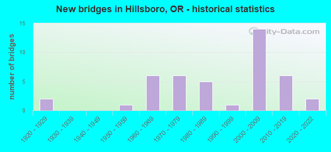
- New bridges - historical statistics
- 21920-1929
- 11950-1959
- 61960-1969
- 61970-1979
- 51980-1989
- 11990-1999
- 142000-2009
- 62010-2019
- 22020-2022
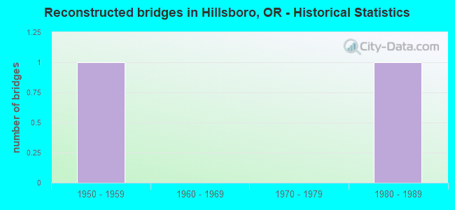
- Reconstructed bridges - Historical Statistics
- 11950-1959
- 01960-1969
- 01970-1979
- 11980-1989
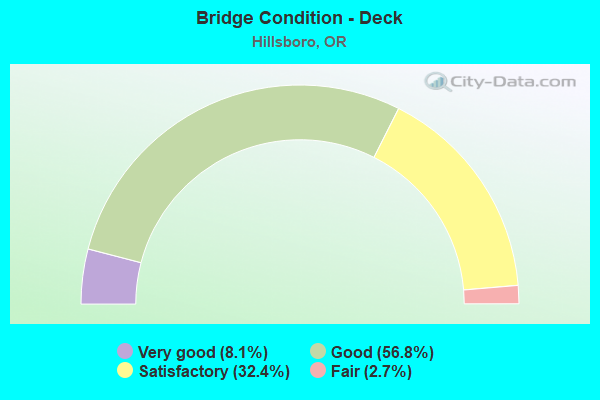
- Bridge Condition - Deck
- 8.1%Very good
- 56.8%Good
- 32.4%Satisfactory
- 2.7%Fair
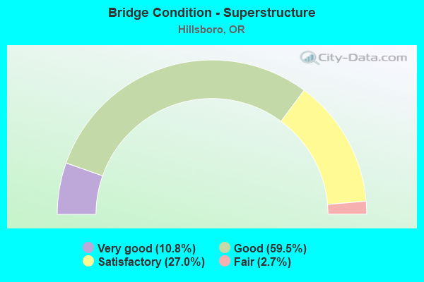
- Bridge Condition - Superstructure
- 10.8%Very good
- 59.5%Good
- 27.0%Satisfactory
- 2.7%Fair
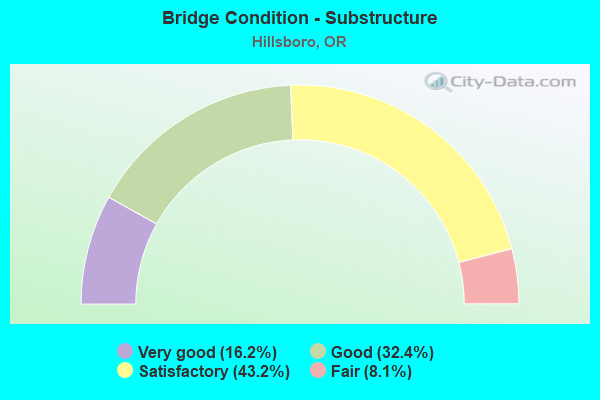
- Bridge Condition - Substructure
- 16.2%Very good
- 32.4%Good
- 43.2%Satisfactory
- 8.1%Fair
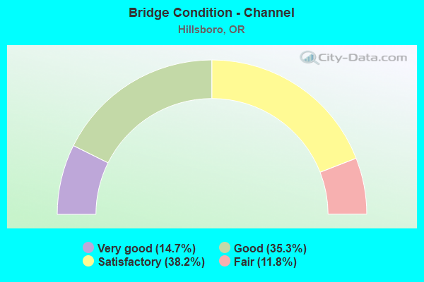
- Bridge Condition - Channel
- 14.7%Very good
- 35.3%Good
- 38.2%Satisfactory
- 11.8%Fair
Find on map >> Show street view
Structure Number: 744B029 01431, Location: 2.9 MI E FOREST GROVE (Lat: 45.520000, Lng: -123.010861), Route carried "on" structure: State highway 8, Year Built: 1923, Year Reconstructed: 1956, Status: Open, Structure Length: 10.06m (33.01ft), Average Daily Traffic: 28,205 (year 2020), Truck Traffic: 6%, Average Future Daily Traffic: 40,400 (year 2040), Design Load: H 15, Features Intersected: DAIRY CREEK, Facility Carried by Structure: HWY 29
Minimum Vertical Clearance: 30+ m (98+ ft), Kilometerpoint: 23.030, Lanes on structure: 4, Base Highway Network: Yes, Owner: State Highway Agency, Approaching Roadway Width: 19.8m (65.0ft), Skew: 22 degrees, Material/Design: Concrete continuous, Design/Construction: Tee Beam, Number Of Spans In Main Unit: 7, Length of Maximum Span: 15.2m (49.9ft), Curb or Sidewalk Widths: Left: 1.1m (3.6ft), Right: 1.1m (3.6ft), Curb-To-Curb Width: 17.7m (58.1ft), Out-to-Out Width: 20.7m (67.9ft)
Condition: Deck: Satisfactory, Superstructure: Satisfactory, Substructure: Satisfactory, Channel: Fair, Operating Rating: 35.4 metric tons, Method Used To Determine Operating Rating: Load Factor (LF), Inventory Rating: 20.9 metric tons, Method Used To Determine Inventory Rating: Load Factor (LF), Structural Evaluation: Somewhat better than minimum adequacy, Deck Geometry: Somewhat better than minimum adequacy, Waterway Adequacy: Equal to present desirable criteria, Approach Roadway Alignment: Equal to present desirable criteria, Designated Inspection Frequency: Every 24 months, Underwater Inspection Frequency: Every 36 months, Inspection Date: April 2020, Underwater Inspection Date: April 2021, Deck Structure Type: Concrete Cast-file-Place, Wearing Surface/Protective System: Wearing Surface: Bituminous
Find on map >> Show street view
Structure Number: 1081 140 00139, Location: 001 MI S HILLSBORO (Lat: 45.500161, Lng: -122.991289), Route carried "on" structure: State highway 219, Year Built: 1924, Year Reconstructed: 1989, Status: Open, Structure Length: 4.57m (14.99ft), Average Daily Traffic: 8,147 (year 2020), Truck Traffic: 8%, Average Future Daily Traffic: 10,800 (year 2040), Design Load: H 15, Features Intersected: TUALATIN RIVER, Facility Carried by Structure: HWY 140
Minimum Vertical Clearance: 30+ m (98+ ft), Kilometerpoint: 2.237, Lanes on structure: 2, Base Highway Network: Yes, Owner: State Highway Agency, Approaching Roadway Width: 12.2m (40.0ft), Material/Design: Concrete continuous, Design/Construction: Tee Beam, Number Of Spans In Main Unit: 3, Length of Maximum Span: 15.2m (49.9ft), Curb-To-Curb Width: 12.2m (40.0ft), Out-to-Out Width: 13.0m (42.7ft)
Condition: Deck: Good, Superstructure: Satisfactory, Substructure: Fair, Channel: Satisfactory, Operating Rating: 44.5 metric tons, Method Used To Determine Operating Rating: Load Factor (LF), Inventory Rating: 26.3 metric tons, Method Used To Determine Inventory Rating: Load Factor (LF), Structural Evaluation: Somewhat better than minimum adequacy, Deck Geometry: Somewhat better than minimum adequacy, Waterway Adequacy: Better than present minimum criteria, Approach Roadway Alignment: Equal to present desirable criteria, Designated Inspection Frequency: Every 24 months, Underwater Inspection Frequency: Every 36 months, Inspection Date: April 2020, Underwater Inspection Date: September 2021, Deck Structure Type: Concrete Cast-file-Place, Wearing Surface/Protective System: Wearing Surface: Bituminous, Deck Protection: Epoxy Coated Reinforcing
Find on map >> Show street view
Structure Number: 1754A029 01055, Location: 1.5 MI E HILLSBORO CC (Lat: 45.502181, Lng: -122.947650), Route carried "on" structure: State highway 8, Year Built: 1961, Status: Open, Structure Length: 6.40m (21.00ft), Average Daily Traffic: 22,459 (year 2020), Truck Traffic: 3%, Average Future Daily Traffic: 31,700 (year 2040), Design Load: HS 20, Features Intersected: DAWSON CREEK, Facility Carried by Structure: HWY 29
Minimum Vertical Clearance: 30+ m (98+ ft), Kilometerpoint: 16.979, Lanes on structure: 4, Base Highway Network: Yes, Owner: State Highway Agency, Approaching Roadway Width: 21.3m (69.9ft), Skew: 20 degrees, Material/Design: Prestressed concrete, Design/Construction: Stringer/Multi-beam, Number Of Spans In Main Unit: 5, Length of Maximum Span: 12.8m (42.0ft), Curb-To-Curb Width: 21.3m (69.9ft), Out-to-Out Width: 24.0m (78.7ft)
Condition: Deck: Good, Superstructure: Good, Substructure: Good, Channel: Good, Operating Rating: 58.3 metric tons, Method Used To Determine Operating Rating: Load and Resistance Factor Rating (LRFR) rating reported by rating factor(RF) method using HL-93 loadings, Inventory Rating: 45.0 metric tons, Method Used To Determine Inventory Rating: Load and Resistance Factor Rating (LRFR) rating reported by rating factor(RF) method using HL-93 loadings, Structural Evaluation: Better than present minimum criteria, Deck Geometry: Superior to present desirable criteria, Waterway Adequacy: Equal to present desirable criteria, Approach Roadway Alignment: Equal to present desirable criteria, Designated Inspection Frequency: Every 24 months, Inspection Date: April 2020, Deck Structure Type: Concrete Cast-file-Place, Wearing Surface/Protective System: Wearing Surface: Bituminous
Find on map >> Show street view
Structure Number: 2365A047 05785, Location: 16.6 MI W of Portland CC (Lat: 45.585800, Lng: -122.984600), Route carried "on" structure: US 26, Year Built: 1968, Status: Open, Structure Length: 3.82m (12.53ft), Average Daily Traffic: 18,378 (year 2020), Truck Traffic: 8%, Average Future Daily Traffic: 34,600 (year 2040), Design Load: HS 20, Features Intersected: Mckay Creek
Minimum Vertical Clearance: 30+ m (98+ ft), Kilometerpoint: 93.101, Lanes on structure: 2, Base Highway Network: Yes, Owner: State Highway Agency, Approaching Roadway Width: 12.8m (42.0ft), Material/Design: Prestressed concrete, Design/Construction: Slab, Number Of Spans In Main Unit: 3, Length of Maximum Span: 12.8m (42.0ft), Curb-To-Curb Width: 12.8m (42.0ft), Out-to-Out Width: 13.4m (44.0ft)
Condition: Deck: Good, Superstructure: Satisfactory, Substructure: Satisfactory, Channel: Good, Operating Rating: 40.2 metric tons, Method Used To Determine Operating Rating: Load and Resistance Factor Rating (LRFR) rating reported by rating factor(RF) method using HL-93 loadings, Inventory Rating: 31.1 metric tons, Method Used To Determine Inventory Rating: Load and Resistance Factor Rating (LRFR) rating reported by rating factor(RF) method using HL-93 loadings, Structural Evaluation: Equal to present minimum criteria, Deck Geometry: Equal to present desirable criteria, Waterway Adequacy: Equal to present desirable criteria, Approach Roadway Alignment: Equal to present desirable criteria, Designated Inspection Frequency: Every 24 months, Inspection Date: September 2020, Deck Structure Type: Concrete Precast Panels, Wearing Surface/Protective System: Wearing Surface: Bituminous
Find on map >> Show street view
Structure Number: 2742A140 00721, Location: 113 MI N NEWBERG (Lat: 45.425881, Lng: -122.960969), Route carried "on" structure: State highway 219, Year Built: 1960, Status: Open, Structure Length: 2.07m (6.79ft), Average Daily Traffic: 4,802 (year 2020), Truck Traffic: 11%, Average Future Daily Traffic: 7,400 (year 2040), Design Load: HS 20, Features Intersected: BURRIS CREEK, Facility Carried by Structure: HWY 140
Minimum Vertical Clearance: 30+ m (98+ ft), Kilometerpoint: 11.603, Lanes on structure: 2, Base Highway Network: Yes, Owner: State Highway Agency, Approaching Roadway Width: 8.2m (26.9ft), Material/Design: Prestressed concrete, Design/Construction: Slab, Number Of Spans In Main Unit: 3, Length of Maximum Span: 7.0m (23.0ft), Curb-To-Curb Width: 8.2m (26.9ft), Out-to-Out Width: 9.8m (32.2ft)
Condition: Deck: Good, Superstructure: Good, Substructure: Satisfactory, Channel: Satisfactory, Operating Rating: 33.7 metric tons, Method Used To Determine Operating Rating: Load and Resistance Factor Rating (LRFR) rating reported by rating factor(RF) method using HL-93 loadings, Inventory Rating: 25.9 metric tons, Method Used To Determine Inventory Rating: Load and Resistance Factor Rating (LRFR) rating reported by rating factor(RF) method using HL-93 loadings, Structural Evaluation: Equal to present minimum criteria, Deck Geometry: High priority of corrective action, Waterway Adequacy: Better than present minimum criteria, Approach Roadway Alignment: Equal to present desirable criteria, Length Of Structure Improvement: 2.10m (6.89ft), Designated Inspection Frequency: Every 24 months, Inspection Date: April 2020, Bridge Improvement Cost: $218,000, Roadway Improvement Cost: $22,000, Total Project Cost: $348,000, Deck Structure Type: Concrete Cast-file-Place, Wearing Surface/Protective System: Wearing Surface: Bituminous
Find on map >> Show street view
Structure Number: 4962A140 00102, Location: 0.9 MI N OF HWY 29 (Lat: 45.505461, Lng: -122.990961), Route carried "on" structure: State highway 219, Year Built: 1966, Status: Open, Structure Length: 4.63m (15.19ft), Average Daily Traffic: 8,147 (year 2020), Truck Traffic: 8%, Average Future Daily Traffic: 10,800 (year 2040), Design Load: HS 20, Features Intersected: JACKSON BOTTOM SLOUGH, Facility Carried by Structure: HWY 140
Minimum Vertical Clearance: 30+ m (98+ ft), Kilometerpoint: 1.642, Lanes on structure: 2, Base Highway Network: Yes, Owner: State Highway Agency, Approaching Roadway Width: 8.8m (28.9ft), Material/Design: Prestressed concrete, Design/Construction: Slab, Number Of Spans In Main Unit: 8, Length of Maximum Span: 5.8m (19.0ft), Curb or Sidewalk Widths: Left: 0.5m (1.6ft), Right: 0.5m (1.6ft), Curb-To-Curb Width: 9.8m (32.2ft), Out-to-Out Width: 11.2m (36.7ft)
Condition: Deck: Good, Superstructure: Good, Substructure: Fair, Channel: Satisfactory, Operating Rating: 31.1 metric tons, Method Used To Determine Operating Rating: Load and Resistance Factor Rating (LRFR) rating reported by rating factor(RF) method using HL-93 loadings, Inventory Rating: 24.0 metric tons, Method Used To Determine Inventory Rating: Load and Resistance Factor Rating (LRFR) rating reported by rating factor(RF) method using HL-93 loadings, Structural Evaluation: Somewhat better than minimum adequacy, Deck Geometry: Meets minimum limits, Waterway Adequacy: Equal to present minimum criteria, Approach Roadway Alignment: Equal to present desirable criteria, Designated Inspection Frequency: Every 24 months, Inspection Date: April 2020, Deck Structure Type: Concrete Precast Panels, Wearing Surface/Protective System: Wearing Surface: Bituminous
Find on map >> Show street view
Structure Number: 6735A047C06257, Location: 11.9 MI W OF PORTLAND CC (Lat: 45.554517, Lng: -122.900847), Route carried "on" structure: County highway 26, Year Built: 1988, Status: Open, Structure Length: 10.06m (33.01ft), Average Daily Traffic: 32,418 (year 2020), Truck Traffic: 8%, Average Future Daily Traffic: 59,778 (year 2030), Design Load: HS 25 or greater, Features Intersected: Hwy 47 (US 26), Facility Carried by Structure: Cornelius Pass Rd
Minimum Vertical Clearance: 30+ m (98+ ft), Kilometerpoint: 100.536, Lanes on structure: 4, Lanes under structure: 6, Owner: State Highway Agency, Approaching Roadway Width: 26.2m (86.0ft), Skew: 3 degrees, Material/Design: Prestressed concrete continuous, Design/Construction: Stringer/Multi-beam, Number Of Spans In Main Unit: 2, Length of Maximum Span: 51.8m (169.9ft), Curb or Sidewalk Widths: Left: 2.4m (7.9ft), Right: 2.4m (7.9ft), Curb-To-Curb Width: 26.2m (86.0ft), Out-to-Out Width: 32.1m (105.3ft)
Condition: Deck: Satisfactory, Superstructure: Good, Substructure: Satisfactory, Operating Rating: 36.0 metric tons, Method Used To Determine Operating Rating: Load and Resistance Factor Rating (LRFR) rating reported by rating factor(RF) method using HL-93 loadings, Inventory Rating: 27.9 metric tons, Method Used To Determine Inventory Rating: Load and Resistance Factor Rating (LRFR) rating reported by rating factor(RF) method using HL-93 loadings, Structural Evaluation: Equal to present minimum criteria, Deck Geometry: Superior to present desirable criteria, Underclear: Somewhat better than minimum adequacy, Approach Roadway Alignment: Equal to present desirable criteria, Designated Inspection Frequency: Every 24 months, Inspection Date: October 2020, Deck Structure Type: Concrete Cast-file-Place, Wearing Surface/Protective System: Wearing Surface: Epoxy Overlay, Deck Protection: Epoxy Coated Reinforcing
Find on map >> Show street view
Structure Number: 9722 047C06111, Location: 13.4 MI W OF PORTLAND CC (Lat: 45.563969, Lng: -122.926189), Route carried "on" structure: Ramp US 26, Year Built: 1985, Status: Open, Structure Length: 9.60m (31.50ft), Average Daily Traffic: 15,110 (year 2020), Truck Traffic: 8%, Average Future Daily Traffic: 21,000 (year 2030), Design Load: HS 25 or greater, Features Intersected: Hwy 47 US 26, Facility Carried by Structure: Helevetia Rd
Minimum Vertical Clearance: 5.39m (17.68ft), Kilometerpoint: 98.267, Lanes on structure: 3, Lanes under structure: 4, Owner: State Highway Agency, Approaching Roadway Width: 23.2m (76.1ft), Skew: 2 degrees, Material/Design: Steel continuous, Design/Construction: Stringer/Multi-beam, Number Of Spans In Main Unit: 2, Length of Maximum Span: 51.8m (169.9ft), Curb or Sidewalk Widths: Left: 2.1m (6.9ft), Right: 2.1m (6.9ft), Curb-To-Curb Width: 23.2m (76.1ft), Out-to-Out Width: 32.2m (105.6ft)
Condition: Deck: Fair, Superstructure: Good, Substructure: Satisfactory, Operating Rating: 48.0 metric tons, Method Used To Determine Operating Rating: Load and Resistance Factor Rating (LRFR) rating reported by rating factor(RF) method using HL-93 loadings, Inventory Rating: 36.9 metric tons, Method Used To Determine Inventory Rating: Load and Resistance Factor Rating (LRFR) rating reported by rating factor(RF) method using HL-93 loadings, Structural Evaluation: Equal to present minimum criteria, Deck Geometry: Superior to present desirable criteria, Underclear: Equal to present desirable criteria, Approach Roadway Alignment: Equal to present desirable criteria, Designated Inspection Frequency: Every 24 months, Critical Feature Inspection Frequency: Every 24 months, Inspection Date: October 2020, Critical Feature Inspection Date: October 2020, Deck Structure Type: Concrete Cast-file-Place, Wearing Surface/Protective System: Wearing Surface: Monolithic Concrete, Deck Protection: Epoxy Coated Reinforcing
Find on map >> Show street view
Structure Number: 9770 047C06429, Location: 10.2 MI W OF PORTLAND CC (Lat: 45.541869, Lng: -122.867561), Route carried "on" structure: County highway 26, Year Built: 1972, Status: Open, Structure Length: 8.08m (26.51ft), Average Daily Traffic: 34,707 (year 2020), Truck Traffic: 5%, Average Future Daily Traffic: 30,684 (year 2030), Design Load: HS 20, Features Intersected: Hwy 47 US 26, Facility Carried by Structure: NW 185TH Ave
Minimum Vertical Clearance: 30+ m (98+ ft), Kilometerpoint: 103.465, Lanes on structure: 6, Lanes under structure: 5, Owner: State Highway Agency, Approaching Roadway Width: 29.9m (98.1ft), Skew: 22 degrees, Material/Design: Prestressed concrete continuous, Design/Construction: Stringer/Multi-beam, Number Of Spans In Main Unit: 2, Length of Maximum Span: 41.1m (134.8ft), Curb or Sidewalk Widths: Left: 1.8m (5.9ft), Right: 1.8m (5.9ft), Curb-To-Curb Width: 29.9m (98.1ft), Out-to-Out Width: 34.5m (113.2ft)
Condition: Deck: Satisfactory, Superstructure: Satisfactory, Substructure: Satisfactory, Operating Rating: 42.1 metric tons, Method Used To Determine Operating Rating: Load and Resistance Factor Rating (LRFR) rating reported by rating factor(RF) method using HL-93 loadings, Inventory Rating: 32.7 metric tons, Method Used To Determine Inventory Rating: Load and Resistance Factor Rating (LRFR) rating reported by rating factor(RF) method using HL-93 loadings, Structural Evaluation: Equal to present minimum criteria, Deck Geometry: Superior to present desirable criteria, Underclear: Equal to present desirable criteria, Approach Roadway Alignment: Equal to present desirable criteria, Designated Inspection Frequency: Every 24 months, Inspection Date: October 2020, Deck Structure Type: Concrete Cast-file-Place, Wearing Surface/Protective System: Wearing Surface: Monolithic Concrete
Find on map >> Show street view
Structure Number: 18740 1145006, Location: .4 Mi E Cornelius Pass (Lat: 45.536669, Lng: -122.890781), Route carried "on" structure: County highway C0000, Year Built: 1998, Status: Open, Structure Length: 2.50m (8.20ft), Average Daily Traffic: 2,833 (year 2020), Truck Traffic: 18%, Average Future Daily Traffic: 3,125 (year 2025), Design Load: HS 20, Features Intersected: ROCK CR, Facility Carried by Structure: NW AMBERWOOD DRIVE
Minimum Vertical Clearance: 30+ m (98+ ft), Kilometerpoint: 10.622, Lanes on structure: 2, Owner: City or Municipal Highway Agency, Approaching Roadway Width: 11.9m (39.0ft), Material/Design: Prestressed concrete, Design/Construction: Tee Beam, Number Of Spans In Main Unit: 1, Length of Maximum Span: 25.0m (82.0ft), Curb or Sidewalk Widths: Left: 1.5m (4.9ft), Right: 1.5m (4.9ft), Curb-To-Curb Width: 15.1m (49.5ft), Out-to-Out Width: 18.8m (61.7ft)
Condition: Deck: Good, Superstructure: Good, Substructure: Satisfactory, Channel: Satisfactory, Operating Rating: 56.2 metric tons, Method Used To Determine Operating Rating: Load Factor (LF), Inventory Rating: 33.6 metric tons, Method Used To Determine Inventory Rating: Load Factor (LF), Structural Evaluation: Equal to present minimum criteria, Deck Geometry: Superior to present desirable criteria, Waterway Adequacy: Equal to present desirable criteria, Approach Roadway Alignment: Equal to present desirable criteria, Designated Inspection Frequency: Every 24 months, Inspection Date: July 2020, Deck Structure Type: Other, Wearing Surface/Protective System: Wearing Surface: Bituminous
Find on map >> Show street view
Structure Number: 19185, Location: W of John Olsen Ave (Lat: 45.538461, Lng: -122.889469), Route carried "on" structure: County highway , Year Built: 2001, Status: Open, Structure Length: 0.98m (3.22ft), Average Daily Traffic: 24,439 (year 2020), Truck Traffic: 2%, Average Future Daily Traffic: 35,309 (year 2025), Design Load: HS 20, Features Intersected: ROCK CREEK OVERFLOW, Facility Carried by Structure: CORNELL ROAD
Minimum Vertical Clearance: 30+ m (98+ ft), Kilometerpoint: 0.000, Lanes on structure: 4, Owner: County Highway Agency, Approaching Roadway Width: 14.6m (47.9ft), Material/Design: Aluminum, Iron, Design/Construction: Culvert, Number Of Spans In Main Unit: 1, Length of Maximum Span: 9.8m (32.2ft)
Condition: Channel: Good, Culverts: Good, Operating Rating: 62.5 metric tons, Method Used To Determine Operating Rating: Load and Resistance Factor Rating (LRFR) rating reported by rating factor(RF) method using HL-93 loadings, Inventory Rating: 48.3 metric tons, Method Used To Determine Inventory Rating: Load and Resistance Factor Rating (LRFR) rating reported by rating factor(RF) method using HL-93 loadings, Structural Evaluation: Better than present minimum criteria, Waterway Adequacy: Equal to present desirable criteria, Approach Roadway Alignment: Equal to present desirable criteria, Designated Inspection Frequency: Every 24 months, Inspection Date: July 2020
Find on map >> Show street view
Structure Number: 19186, Location: W of John Olsen Ave (Lat: 45.538600, Lng: -122.890139), Route carried "on" structure: County highway , Year Built: 2001, Status: Open, Structure Length: 0.92m (3.02ft), Average Daily Traffic: 24,439 (year 2020), Truck Traffic: 2%, Average Future Daily Traffic: 35,309 (year 2025), Design Load: HS 20, Features Intersected: ROCK CREEK, Facility Carried by Structure: CORNELL ROAD
Minimum Vertical Clearance: 30+ m (98+ ft), Kilometerpoint: 0.000, Lanes on structure: 4, Owner: County Highway Agency, Approaching Roadway Width: 14.6m (47.9ft), Material/Design: Aluminum, Iron, Design/Construction: Culvert, Number Of Spans In Main Unit: 1, Length of Maximum Span: 9.2m (30.2ft)
Condition: Channel: Good, Culverts: Good, Operating Rating: 89.7 metric tons, Method Used To Determine Operating Rating: Load and Resistance Factor Rating (LRFR) rating reported by rating factor(RF) method using HL-93 loadings, Inventory Rating: 69.0 metric tons, Method Used To Determine Inventory Rating: Load and Resistance Factor Rating (LRFR) rating reported by rating factor(RF) method using HL-93 loadings, Structural Evaluation: Better than present minimum criteria, Waterway Adequacy: Equal to present desirable criteria, Approach Roadway Alignment: Equal to present desirable criteria, Designated Inspection Frequency: Every 24 months, Inspection Date: July 2020
Find on map >> Show street view
Structure Number: 19187, Location: 2.2 MI N TV HWY. (Lat: 45.528661, Lng: -122.937581), Route carried "on" structure: City street , Year Built: 2001, Status: Open, Structure Length: 3.26m (10.70ft), Average Daily Traffic: 11,788 (year 2020), Truck Traffic: 2%, Average Future Daily Traffic: 13,001 (year 2025), Design Load: HS 20, Features Intersected: TRI MET LIGHT RAIL TRACK, Facility Carried by Structure: BROOKWOOD AVE
Minimum Vertical Clearance: 30+ m (98+ ft), Kilometerpoint: 0.000, Lanes on structure: 2, Owner: County Highway Agency, Approaching Roadway Width: 17.1m (56.1ft), Skew: 1 degrees, Material/Design: Prestressed concrete, Design/Construction: Slab, Number Of Spans In Main Unit: 3, Length of Maximum Span: 12.5m (41.0ft), Curb or Sidewalk Widths: Left: 2.1m (6.9ft), Right: 2.1m (6.9ft), Curb-To-Curb Width: 12.2m (40.0ft), Out-to-Out Width: 17.1m (56.1ft)
Condition: Deck: Satisfactory, Superstructure: Satisfactory, Substructure: Satisfactory, Operating Rating: 80.7 metric tons, Method Used To Determine Operating Rating: Load Factor (LF), Inventory Rating: 51.7 metric tons, Method Used To Determine Inventory Rating: Load Factor (LF), Structural Evaluation: Equal to present minimum criteria, Deck Geometry: Somewhat better than minimum adequacy, Underclear: High priority of corrective action, Approach Roadway Alignment: Equal to present desirable criteria, Length Of Structure Improvement: 3.30m (10.83ft), Designated Inspection Frequency: Every 24 months, Inspection Date: October 2020, Bridge Improvement Cost: $343,000, Roadway Improvement Cost: $34,000, Total Project Cost: $548,000, Deck Structure Type: Other, Wearing Surface/Protective System: Wearing Surface: Bituminous
Find on map >> Show street view
Structure Number: 19193 09350019, Location: 001 MI N TUALATIN RIVER (Lat: 45.485889, Lng: -122.981161), Route carried "on" structure: County highway C0139, Year Built: 2002, Status: Open, Structure Length: 5.84m (19.16ft), Average Daily Traffic: 7,649 (year 2020), Truck Traffic: 5%, Average Future Daily Traffic: 11,497 (year 2025), Design Load: HS 25 or greater, Features Intersected: TUALATIN RIVER OVERFLOW, Facility Carried by Structure: MINTER BRIDGE ROAD
Minimum Vertical Clearance: 30+ m (98+ ft), Kilometerpoint: 2.531, Lanes on structure: 2, Owner: County Highway Agency, Approaching Roadway Width: 11.0m (36.1ft), Material/Design: Prestressed concrete continuous, Design/Construction: Stringer/Multi-beam, Number Of Spans In Main Unit: 2, Length of Maximum Span: 29.0m (95.1ft), Curb-To-Curb Width: 10.8m (35.4ft), Out-to-Out Width: 11.6m (38.1ft)
Condition: Deck: Good, Superstructure: Good, Substructure: Good, Channel: Very good, Operating Rating: 71.7 metric tons, Method Used To Determine Operating Rating: Load Factor (LF), Inventory Rating: 42.6 metric tons, Method Used To Determine Inventory Rating: Load Factor (LF), Structural Evaluation: Better than present minimum criteria, Deck Geometry: Meets minimum limits, Waterway Adequacy: Equal to present desirable criteria, Approach Roadway Alignment: Equal to present minimum criteria, Designated Inspection Frequency: Every 24 months, Inspection Date: September 2020, Deck Structure Type: Concrete Cast-file-Place, Wearing Surface/Protective System: Wearing Surface: Epoxy Overlay, Deck Protection: Epoxy Coated Reinforcing
Find on map >> Show street view
Structure Number: 19194 0935002, Location: 018 MI S RIVER ROAD (Lat: 45.484889, Lng: -122.982169), Route carried "on" structure: County highway C0139, Year Built: 2002, Status: Open, Structure Length: 6.43m (21.10ft), Average Daily Traffic: 7,649 (year 2020), Truck Traffic: 5%, Average Future Daily Traffic: 11,497 (year 2025), Design Load: HS 25 or greater, Features Intersected: TUALATIN RIVER, Facility Carried by Structure: MINTER BRIDGE ROAD
Minimum Vertical Clearance: 30+ m (98+ ft), Kilometerpoint: 2.393, Lanes on structure: 2, Owner: County Highway Agency, Approaching Roadway Width: 11.0m (36.1ft), Material/Design: Prestressed concrete, Design/Construction: Stringer/Multi-beam, Number Of Spans In Main Unit: 1, Length of Maximum Span: 63.0m (206.7ft), Curb-To-Curb Width: 10.8m (35.4ft), Out-to-Out Width: 11.6m (38.1ft)
Condition: Deck: Good, Superstructure: Very good, Substructure: Very good, Channel: Good, Operating Rating: 32.7 metric tons, Method Used To Determine Operating Rating: Load and Resistance Factor Rating (LRFR) rating reported by rating factor(RF) method using HL-93 loadings, Inventory Rating: 25.3 metric tons, Method Used To Determine Inventory Rating: Load and Resistance Factor Rating (LRFR) rating reported by rating factor(RF) method using HL-93 loadings, Structural Evaluation: Equal to present minimum criteria, Deck Geometry: Meets minimum limits, Waterway Adequacy: Equal to present desirable criteria, Approach Roadway Alignment: Equal to present minimum criteria, Designated Inspection Frequency: Every 24 months, Inspection Date: September 2020, Deck Structure Type: Concrete Cast-file-Place, Wearing Surface/Protective System: Wearing Surface: Epoxy Overlay, Deck Protection: Epoxy Coated Reinforcing
Find on map >> Show street view
Structure Number: 19592 047 0587, Location: 15.75 MI W Portland CC (Lat: 45.579761, Lng: -122.968169), Route carried "on" structure: Ramp State highway , Year Built: 2006, Status: Open, Structure Length: 8.45m (27.72ft), Average Daily Traffic: 8,781 (year 2020), Truck Traffic: 8%, Average Future Daily Traffic: 4,808 (year 2030), Design Load: HL 93, Features Intersected: US 26 (HWY 047), Facility Carried by Structure: Jackson School Rd
Minimum Vertical Clearance: 30+ m (98+ ft), Kilometerpoint: 94.549, Lanes on structure: 2, Lanes under structure: 4, Base Highway Network: Yes, Owner: State Highway Agency, Approaching Roadway Width: 24.0m (78.7ft), Material/Design: Prestressed concrete continuous, Design/Construction: Stringer/Multi-beam, Number Of Spans In Main Unit: 2, Length of Maximum Span: 42.5m (139.4ft), Curb-To-Curb Width: 24.0m (78.7ft), Out-to-Out Width: 25.1m (82.3ft)
Condition: Deck: Good, Superstructure: Good, Substructure: Satisfactory, Operating Rating: 27.2 metric tons, Method Used To Determine Operating Rating: Load and Resistance Factor Rating (LRFR) rating reported by rating factor(RF) method using HL-93 loadings, Inventory Rating: 20.7 metric tons, Method Used To Determine Inventory Rating: Load and Resistance Factor Rating (LRFR) rating reported by rating factor(RF) method using HL-93 loadings, Structural Evaluation: Somewhat better than minimum adequacy, Deck Geometry: Superior to present desirable criteria, Underclear: Better than present minimum criteria, Approach Roadway Alignment: Equal to present desirable criteria, Designated Inspection Frequency: Every 24 months, Inspection Date: September 2020, Deck Structure Type: Concrete Cast-file-Place, Wearing Surface/Protective System: Wearing Surface: Monolithic Concrete
Find on map >> Show street view
Structure Number: 19619 022, Location: 030 MI N FARMINGTON ROAD (Lat: 45.489569, Lng: -122.951419), Route carried "on" structure: County highway C0022, Year Built: 2004, Status: Open, Structure Length: 20.85m (68.41ft), Average Daily Traffic: 6,556 (year 2020), Truck Traffic: 5%, Average Future Daily Traffic: 9,537 (year 2025), Design Load: HL 93, Features Intersected: TUALATIN RIVER, Facility Carried by Structure: ROOD BRIDGE RD
Minimum Vertical Clearance: 30+ m (98+ ft), Kilometerpoint: 4.836, Lanes on structure: 2, Owner: County Highway Agency, Approaching Roadway Width: 11.6m (38.1ft), Material/Design: Prestressed concrete continuous, Design/Construction: Stringer/Multi-beam, Number Of Spans In Main Unit: 6, Length of Maximum Span: 36.6m (120.1ft), Curb-To-Curb Width: 11.4m (37.4ft), Out-to-Out Width: 12.3m (40.4ft)
Condition: Deck: Very good, Superstructure: Very good, Substructure: Very good, Channel: Good, Operating Rating: 79.8 metric tons, Method Used To Determine Operating Rating: Load Factor (LF), Inventory Rating: 48.1 metric tons, Method Used To Determine Inventory Rating: Load Factor (LF), Structural Evaluation: Equal to present desirable criteria, Deck Geometry: Meets minimum limits, Waterway Adequacy: Equal to present desirable criteria, Approach Roadway Alignment: Equal to present desirable criteria, Designated Inspection Frequency: Every 24 months, Inspection Date: September 2020, Deck Structure Type: Concrete Cast-file-Place, Wearing Surface/Protective System: Wearing Surface: Monolithic Concrete, Deck Protection: Epoxy Coated Reinforcing
Find on map >> Show street view
Structure Number: 19878, Location: 001 MI E 231ST AVE (Lat: 45.520381, Lng: -122.913119), Route carried "on" structure: County highway C0223, Year Built: 2005, Status: Open, Structure Length: 3.30m (10.83ft), Average Daily Traffic: 16,198 (year 2020), Truck Traffic: 5%, Average Future Daily Traffic: 16,948 (year 2025), Design Load: HS 25 or greater, Features Intersected: ROCK CREEK, Facility Carried by Structure: BASELINE RD
Minimum Vertical Clearance: 30+ m (98+ ft), Kilometerpoint: 0.000, Lanes on structure: 4, Owner: County Highway Agency, Approaching Roadway Width: 27.4m (89.9ft), Material/Design: Prestressed concrete, Design/Construction: Stringer/Multi-beam, Number Of Spans In Main Unit: 1, Length of Maximum Span: 33.0m (108.3ft), Curb or Sidewalk Widths: Left: 2.4m (7.9ft), Right: 2.4m (7.9ft), Curb-To-Curb Width: 21.9m (71.9ft), Out-to-Out Width: 27.4m (89.9ft)
Condition: Deck: Good, Superstructure: Good, Substructure: Good, Channel: Satisfactory, Operating Rating: 89.8 metric tons, Method Used To Determine Operating Rating: Load Factor (LF), Inventory Rating: 81.6 metric tons, Method Used To Determine Inventory Rating: Load Factor (LF), Structural Evaluation: Better than present minimum criteria, Deck Geometry: Superior to present desirable criteria, Waterway Adequacy: Equal to present desirable criteria, Approach Roadway Alignment: Equal to present desirable criteria, Designated Inspection Frequency: Every 24 months, Inspection Date: July 2020, Deck Structure Type: Concrete Cast-file-Place, Wearing Surface/Protective System: Wearing Surface: Monolithic Concrete
Find on map >> Show street view
Structure Number: 19884, Location: 002 MI E 231ST AVE (Lat: 45.519519, Lng: -122.910189), Route carried "on" structure: County highway C0223, Year Built: 2005, Status: Open, Structure Length: 4.30m (14.11ft), Average Daily Traffic: 18,329 (year 2020), Truck Traffic: 5%, Average Future Daily Traffic: 19,079 (year 2025), Design Load: HS 25 or greater, Features Intersected: BEAVERTON CREEK, Facility Carried by Structure: BASELINE RD
Minimum Vertical Clearance: 30+ m (98+ ft), Kilometerpoint: 0.000, Lanes on structure: 4, Owner: County Highway Agency, Approaching Roadway Width: 27.4m (89.9ft), Material/Design: Prestressed concrete, Design/Construction: Stringer/Multi-beam, Number Of Spans In Main Unit: 1, Length of Maximum Span: 43.0m (141.1ft), Curb or Sidewalk Widths: Left: 2.4m (7.9ft), Right: 2.4m (7.9ft), Curb-To-Curb Width: 21.9m (71.9ft), Out-to-Out Width: 27.4m (89.9ft)
Condition: Deck: Good, Superstructure: Good, Substructure: Good, Channel: Satisfactory, Operating Rating: 89.8 metric tons, Method Used To Determine Operating Rating: Load Factor (LF), Inventory Rating: 88.9 metric tons, Method Used To Determine Inventory Rating: Load Factor (LF), Structural Evaluation: Better than present minimum criteria, Deck Geometry: Superior to present desirable criteria, Waterway Adequacy: Equal to present desirable criteria, Approach Roadway Alignment: Equal to present desirable criteria, Designated Inspection Frequency: Every 24 months, Inspection Date: July 2020, Deck Structure Type: Concrete Cast-file-Place, Wearing Surface/Protective System: Wearing Surface: Monolithic Concrete, Deck Protection: Epoxy Coated Reinforcing
Find on map >> Show street view
Structure Number: 19896 140 00549, Location: AT HWY 142 JCT (Lat: 45.442300, Lng: -122.984961), Route carried "on" structure: State highway 219, Year Built: 2007, Status: Open, Structure Length: 4.10m (13.45ft), Average Daily Traffic: 4,161 (year 2020), Truck Traffic: 11%, Average Future Daily Traffic: 11,200 (year 2040), Design Load: HL 93, Features Intersected: CAMPBELLS CREEK, Facility Carried by Structure: HWY 140
Minimum Vertical Clearance: 30+ m (98+ ft), Kilometerpoint: 8.835, Lanes on structure: 3, Base Highway Network: Yes, Owner: State Highway Agency, Approaching Roadway Width: 21.0m (68.9ft), Skew: 20 degrees, Material/Design: Prestressed concrete, Design/Construction: Stringer/Multi-beam, Number Of Spans In Main Unit: 1, Length of Maximum Span: 41.0m (134.5ft), Curb-To-Curb Width: 21.0m (68.9ft), Out-to-Out Width: 21.8m (71.5ft)
Condition: Deck: Satisfactory, Superstructure: Good, Substructure: Satisfactory, Channel: Very good, Operating Rating: 83.6 metric tons, Method Used To Determine Operating Rating: Load and Resistance Factor Rating (LRFR) rating reported by rating factor(RF) method using HL-93 loadings, Inventory Rating: 64.5 metric tons, Method Used To Determine Inventory Rating: Load and Resistance Factor Rating (LRFR) rating reported by rating factor(RF) method using HL-93 loadings, Structural Evaluation: Equal to present minimum criteria, Deck Geometry: Superior to present desirable criteria, Waterway Adequacy: Equal to present desirable criteria, Approach Roadway Alignment: Equal to present desirable criteria, Designated Inspection Frequency: Every 24 months, Inspection Date: April 2020, Deck Structure Type: Concrete Cast-file-Place, Wearing Surface/Protective System: Wearing Surface: Monolithic Concrete
Find on map >> Show street view
Structure Number: 20069 142 00184, Location: 8.0 MI SW BEAVERTON CC (Lat: 45.449489, Lng: -122.950931), Route carried "on" structure: State highway 208, Year Built: 2005, Status: Open, Structure Length: 12.19m (39.99ft), Average Daily Traffic: 13,354 (year 2020), Truck Traffic: 2%, Average Future Daily Traffic: 21,700 (year 2040), Design Load: HL 93, Features Intersected: TUALATIN RIVER, Facility Carried by Structure: Farmington Road
Minimum Vertical Clearance: 30+ m (98+ ft), Kilometerpoint: 0.966, Lanes on structure: 2, Base Highway Network: Yes, Owner: County Highway Agency, Approaching Roadway Width: 13.1m (43.0ft), Material/Design: Prestressed concrete, Design/Construction: Stringer/Multi-beam, Number Of Spans In Main Unit: 4, Length of Maximum Span: 33.0m (108.3ft), Curb-To-Curb Width: 12.2m (40.0ft), Out-to-Out Width: 13.1m (43.0ft)
Condition: Deck: Good, Superstructure: Good, Substructure: Good, Channel: Good, Operating Rating: 67.1 metric tons, Method Used To Determine Operating Rating: Load Factor (LF), Inventory Rating: 40.8 metric tons, Method Used To Determine Inventory Rating: Load Factor (LF), Structural Evaluation: Better than present minimum criteria, Deck Geometry: Somewhat better than minimum adequacy, Waterway Adequacy: Equal to present desirable criteria, Approach Roadway Alignment: Equal to present desirable criteria, Designated Inspection Frequency: Every 24 months, Inspection Date: July 2020, Deck Structure Type: Concrete Cast-file-Place, Wearing Surface/Protective System: Wearing Surface: Monolithic Concrete
Find on map >> Show street view
Structure Number: 20461 09020005, Location: 009 MI EAST OF 264TH AVE (Lat: 45.538161, Lng: -122.935989), Route carried "on" structure: City street C0902, Year Built: 2006, Status: Open, Structure Length: 1.44m (4.72ft), Average Daily Traffic: 54 (year 2020), Truck Traffic: 1%, Average Future Daily Traffic: 60 (year 2025), Design Load: HS 20, Features Intersected: Dawson Cr, Facility Carried by Structure: NE Airport Rd
Minimum Vertical Clearance: 30+ m (98+ ft), Kilometerpoint: 0.805, Lanes on structure: 2, Owner: City or Municipal Highway Agency, Approaching Roadway Width: 20.7m (67.9ft), Skew: 3 degrees, Material/Design: Prestressed concrete, Design/Construction: Slab, Number Of Spans In Main Unit: 1, Length of Maximum Span: 14.0m (45.9ft), Curb or Sidewalk Widths: Left: 1.8m (5.9ft), Right: 1.8m (5.9ft), Curb-To-Curb Width: 14.2m (46.6ft), Out-to-Out Width: 18.3m (60.0ft)
Condition: Deck: Satisfactory, Superstructure: Satisfactory, Substructure: Good, Channel: Good, Operating Rating: 76.2 metric tons, Method Used To Determine Operating Rating: Load Factor (LF), Inventory Rating: 45.4 metric tons, Method Used To Determine Inventory Rating: Load Factor (LF), Structural Evaluation: Equal to present minimum criteria, Deck Geometry: Superior to present desirable criteria, Waterway Adequacy: Equal to present minimum criteria, Approach Roadway Alignment: Equal to present desirable criteria, Designated Inspection Frequency: Every 24 months, Inspection Date: July 2020, Deck Structure Type: Other, Wearing Surface/Protective System: Wearing Surface: Monolithic Concrete
Find on map >> Show street view
Structure Number: 2097, Location: 00.1 EAST ROOD BR ROAD (Lat: 45.497739, Lng: -122.949431), Route carried "on" structure: City street C0000, Year Built: 2009, Status: Open, Structure Length: 5.59m (18.34ft), Average Daily Traffic: 10,661 (year 2020), Truck Traffic: 10%, Average Future Daily Traffic: 11,758 (year 2025), Design Load: HS 20, Features Intersected: ROCK CREEK, Facility Carried by Structure: RIVER RD
Minimum Vertical Clearance: 30+ m (98+ ft), Kilometerpoint: 0.000, Lanes on structure: 2, Owner: County Highway Agency, Approaching Roadway Width: 11.0m (36.1ft), Material/Design: Prestressed concrete, Design/Construction: Stringer/Multi-beam, Number Of Spans In Main Unit: 1, Length of Maximum Span: 55.9m (183.4ft), Curb or Sidewalk Widths: Left: 2.2m (7.2ft), Right: 2.2m (7.2ft), Curb-To-Curb Width: 11.0m (36.1ft), Out-to-Out Width: 16.2m (53.1ft)
Condition: Deck: Satisfactory, Superstructure: Good, Substructure: Good, Channel: Satisfactory, Operating Rating: 74.2 metric tons, Method Used To Determine Operating Rating: Load and Resistance Factor Rating (LRFR) rating reported by rating factor(RF) method using HL-93 loadings, Inventory Rating: 57.3 metric tons, Method Used To Determine Inventory Rating: Load and Resistance Factor Rating (LRFR) rating reported by rating factor(RF) method using HL-93 loadings, Structural Evaluation: Better than present minimum criteria, Deck Geometry: Meets minimum limits, Waterway Adequacy: Better than present minimum criteria, Approach Roadway Alignment: Equal to present desirable criteria, Designated Inspection Frequency: Every 24 months, Inspection Date: October 2020, Deck Structure Type: Concrete Cast-file-Place, Wearing Surface/Protective System: Wearing Surface: Monolithic Concrete
Find on map >> Show street view
Structure Number: 21322 047 05784, Location: 16.6 MI W OF PORTLAND CC (Lat: 45.585989, Lng: -122.984386), Route carried "on" structure: US 26, Year Built: 2010, Status: Open, Structure Length: 5.67m (18.60ft), Average Daily Traffic: 18,378 (year 2020), Truck Traffic: 8%, Average Future Daily Traffic: 34,600 (year 2040), Design Load: HL 93, Features Intersected: McKay Creek
Minimum Vertical Clearance: 30+ m (98+ ft), Kilometerpoint: 93.084, Lanes on structure: 2, Base Highway Network: Yes, Owner: State Highway Agency, Approaching Roadway Width: 12.8m (42.0ft), Material/Design: Prestressed concrete, Design/Construction: Slab, Number Of Spans In Main Unit: 3, Length of Maximum Span: 18.9m (62.0ft), Curb-To-Curb Width: 12.8m (42.0ft), Out-to-Out Width: 13.7m (44.9ft)
Condition: Deck: Good, Superstructure: Good, Substructure: Good, Channel: Very good, Operating Rating: 62.5 metric tons, Method Used To Determine Operating Rating: Load and Resistance Factor Rating (LRFR) rating reported by rating factor(RF) method using HL-93 loadings, Inventory Rating: 48.3 metric tons, Method Used To Determine Inventory Rating: Load and Resistance Factor Rating (LRFR) rating reported by rating factor(RF) method using HL-93 loadings, Structural Evaluation: Better than present minimum criteria, Deck Geometry: Equal to present desirable criteria, Waterway Adequacy: Equal to present minimum criteria, Approach Roadway Alignment: Equal to present desirable criteria, Designated Inspection Frequency: Every 24 months, Inspection Date: September 2020, Deck Structure Type: Concrete Precast Panels, Wearing Surface/Protective System: Wearing Surface: Latex Concrete, Deck Protection: Epoxy Coated Reinforcing
Find on map >> Show street view
Structure Number: 21363 000 0017, Location: MP 1.70 Cornelius Pass Rd (Lat: 45.520972, Lng: -122.899792), Route carried "on" structure: County highway C1112, Year Built: 2010, Status: Open, Structure Length: 5.55m (18.21ft), Average Daily Traffic: 25,168 (year 2020), Truck Traffic: 20%, Average Future Daily Traffic: 27,757 (year 2025), Features Intersected: Hall Creek, Facility Carried by Structure: Cornelius Pass Rd
Minimum Vertical Clearance: 30+ m (98+ ft), Kilometerpoint: 2.736, Lanes on structure: 4, Owner: County Highway Agency, Approaching Roadway Width: 19.8m (65.0ft), Material/Design: Prestressed concrete, Design/Construction: Stringer/Multi-beam, Number Of Spans In Main Unit: 1, Length of Maximum Span: 55.5m (182.1ft), Curb or Sidewalk Widths: Left: 2.6m (8.5ft), Right: 2.6m (8.5ft), Curb-To-Curb Width: 14.7m (48.2ft), Out-to-Out Width: 19.8m (65.0ft)
Condition: Deck: Satisfactory, Superstructure: Good, Substructure: Good, Channel: Good, Operating Rating: 84.9 metric tons, Method Used To Determine Operating Rating: Load and Resistance Factor Rating (LRFR) rating reported by rating factor(RF) method using HL-93 loadings, Inventory Rating: 65.4 metric tons, Method Used To Determine Inventory Rating: Load and Resistance Factor Rating (LRFR) rating reported by rating factor(RF) method using HL-93 loadings, Structural Evaluation: Better than present minimum criteria, Deck Geometry: High priority of replacement, Waterway Adequacy: Equal to present desirable criteria, Approach Roadway Alignment: Equal to present desirable criteria, Designated Inspection Frequency: Every 24 months, Inspection Date: October 2020, Deck Structure Type: Concrete Cast-file-Place, Wearing Surface/Protective System: Wearing Surface: Monolithic Concrete
Find on map >> Show street view
Structure Number: 21696 11120024, Location: 003 MI N R/R UNDERPASS (Lat: 45.529150, Lng: -122.899619), Route carried "on" structure: County highway C1112, Year Built: 2012, Status: Open, Structure Length: 3.44m (11.29ft), Average Daily Traffic: 25,168 (year 2020), Truck Traffic: 5%, Average Future Daily Traffic: 27,757 (year 2025), Design Load: HL 93, Features Intersected: ROCK CREEK, Facility Carried by Structure: CORNELIUS PASS RD
Minimum Vertical Clearance: 30+ m (98+ ft), Kilometerpoint: 3.862, Lanes on structure: 4, Owner: County Highway Agency, Approaching Roadway Width: 7.6m (24.9ft), Material/Design: Prestressed concrete, Design/Construction: Box Beam or Girders - Multiple, Number Of Spans In Main Unit: 1, Length of Maximum Span: 33.2m (108.9ft), Curb or Sidewalk Widths: Left: 2.4m (7.9ft), Right: 2.4m (7.9ft), Curb-To-Curb Width: 11.0m (36.1ft), Out-to-Out Width: 28.1m (92.2ft)
Condition: Deck: Good, Superstructure: Good, Substructure: Very good, Channel: Satisfactory, Operating Rating: 47.0 metric tons, Method Used To Determine Operating Rating: Load and Resistance Factor Rating (LRFR) rating reported by rating factor(RF) method using HL-93 loadings, Inventory Rating: 36.3 metric tons, Method Used To Determine Inventory Rating: Load and Resistance Factor Rating (LRFR) rating reported by rating factor(RF) method using HL-93 loadings, Structural Evaluation: Better than present minimum criteria, Deck Geometry: High priority of replacement, Waterway Adequacy: Equal to present desirable criteria, Approach Roadway Alignment: Equal to present desirable criteria, Designated Inspection Frequency: Every 24 months, Inspection Date: August 2021, Deck Structure Type: Concrete Precast Panels, Wearing Surface/Protective System: Wearing Surface: Bituminous, Deck Protection: Epoxy Coated Reinforcing
Find on map >> Show street view
Structure Number: 21697024950028, Location: 005 N EVERGREEN ROAD (Lat: 45.555461, Lng: -122.995811), Route carried "on" structure: County highway A0685, Year Built: 2011, Status: Open, Structure Length: 3.54m (11.61ft), Average Daily Traffic: 7,882 (year 2020), Truck Traffic: 16%, Average Future Daily Traffic: 8,632 (year 2025), Features Intersected: MCKAY CREEK, Facility Carried by Structure: GLENCOE ROAD
Minimum Vertical Clearance: 30+ m (98+ ft), Kilometerpoint: 4.506, Lanes on structure: 2, Owner: County Highway Agency, Approaching Roadway Width: 15.8m (51.8ft), Material/Design: Prestressed concrete, Design/Construction: Stringer/Multi-beam, Number Of Spans In Main Unit: 1, Length of Maximum Span: 35.4m (116.1ft), Curb-To-Curb Width: 15.8m (51.8ft), Out-to-Out Width: 16.7m (54.8ft)
Condition: Deck: Good, Superstructure: Good, Substructure: Good, Channel: Good, Operating Rating: 46.3 metric tons, Method Used To Determine Operating Rating: Load and Resistance Factor Rating (LRFR) rating reported by rating factor(RF) method using HL-93 loadings, Inventory Rating: 35.6 metric tons, Method Used To Determine Inventory Rating: Load and Resistance Factor Rating (LRFR) rating reported by rating factor(RF) method using HL-93 loadings, Structural Evaluation: Better than present minimum criteria, Deck Geometry: Superior to present desirable criteria, Waterway Adequacy: Equal to present desirable criteria, Approach Roadway Alignment: Equal to present desirable criteria, Designated Inspection Frequency: Every 24 months, Inspection Date: October 2020, Deck Structure Type: Concrete Cast-file-Place, Wearing Surface/Protective System: Wearing Surface: Monolithic Concrete
Find on map >> Show street view
Structure Number: 21740 786 0005, Location: 0055 MI N SIMPSON ROAD (Lat: 45.469461, Lng: -123.009639), Route carried "on" structure: County highway C0786, Year Built: 2016, Status: Open, Structure Length: 2.59m (8.50ft), Average Daily Traffic: 590 (year 2020), Truck Traffic: 2%, Average Future Daily Traffic: 645 (year 2025), Design Load: HL 93, Features Intersected: Davis Creek, Facility Carried by Structure: SW Johnson Sch Rd
Minimum Vertical Clearance: 30+ m (98+ ft), Kilometerpoint: 4.184, Lanes on structure: 2, Owner: County Highway Agency, Approaching Roadway Width: 11.0m (36.1ft), Material/Design: Prestressed concrete, Design/Construction: Box Beam or Girders - Multiple, Number Of Spans In Main Unit: 1, Length of Maximum Span: 25.9m (85.0ft), Curb or Sidewalk Widths: Left: 0.9m (3.0ft), Right: 0.9m (3.0ft), Curb-To-Curb Width: 11.0m (36.1ft), Out-to-Out Width: 12.8m (42.0ft)
Condition: Deck: Good, Superstructure: Good, Substructure: Very good, Channel: Good, Operating Rating: 75.2 metric tons, Method Used To Determine Operating Rating: Load and Resistance Factor Rating (LRFR) rating reported by rating factor(RF) method using HL-93 loadings, Inventory Rating: 58.0 metric tons, Method Used To Determine Inventory Rating: Load and Resistance Factor Rating (LRFR) rating reported by rating factor(RF) method using HL-93 loadings, Structural Evaluation: Better than present minimum criteria, Deck Geometry: Better than present minimum criteria, Waterway Adequacy: Equal to present desirable criteria, Approach Roadway Alignment: Equal to present desirable criteria, Designated Inspection Frequency: Every 24 months, Inspection Date: August 2020, Deck Structure Type: Concrete Precast Panels, Wearing Surface/Protective System: Wearing Surface: Bituminous
Find on map >> Show street view
Structure Number: 22339 047 06338, Location: 11.1 MI W OF PORTLAND CC (Lat: 45.548150, Lng: -122.883844), Route carried "on" structure: US 26, Year Built: 2017, Status: Open, Structure Length: 3.38m (11.09ft), Average Daily Traffic: 100,225 (year 2020), Truck Traffic: 5%, Average Future Daily Traffic: 161,500 (year 2040), Design Load: HL 93, Features Intersected: Rock Creek
Minimum Vertical Clearance: 30+ m (98+ ft), Kilometerpoint: 102.000, Lanes on structure: 6, Base Highway Network: Yes, Owner: State Highway Agency, Approaching Roadway Width: 36.6m (120.1ft), Skew: 30 degrees, Material/Design: Prestressed concrete, Design/Construction: Stringer/Multi-beam, Number Of Spans In Main Unit: 1, Length of Maximum Span: 31.4m (103.0ft), Curb-To-Curb Width: 36.6m (120.1ft), Out-to-Out Width: 38.2m (125.3ft)
Condition: Deck: Good, Superstructure: Good, Substructure: Good, Channel: Very good, Operating Rating: 73.2 metric tons, Method Used To Determine Operating Rating: Load and Resistance Factor Rating (LRFR) rating reported by rating factor(RF) method using HL-93 loadings, Inventory Rating: 56.4 metric tons, Method Used To Determine Inventory Rating: Load and Resistance Factor Rating (LRFR) rating reported by rating factor(RF) method using HL-93 loadings, Structural Evaluation: Better than present minimum criteria, Deck Geometry: Superior to present desirable criteria, Waterway Adequacy: Equal to present desirable criteria, Approach Roadway Alignment: Equal to present desirable criteria, Designated Inspection Frequency: Every 24 months, Inspection Date: October 2020, Deck Structure Type: Concrete Precast Panels, Wearing Surface/Protective System: Wearing Surface: Monolithic Concrete
Find on map >> Show street view
Structure Number: 23295, Location: 005 MI W 216TH AVE (Lat: 45.523439, Lng: -122.909281), Route carried "on" structure: County highway C1445, Year Built: 2020, Status: Open, Structure Length: 3.41m (11.19ft), Average Daily Traffic: 563 (year 2010), Truck Traffic: 2%, Average Future Daily Traffic: 1,093 (year 2030), Design Load: HL 93, Features Intersected: ROCK CREEK, Facility Carried by Structure: NE 69TH AVE
Minimum Vertical Clearance: 30+ m (98+ ft), Kilometerpoint: 0.000, Lanes on structure: 2, Owner: County Highway Agency, Approaching Roadway Width: 6.1m (20.0ft), Material/Design: Prestressed concrete, Design/Construction: Stringer/Multi-beam, Number Of Spans In Main Unit: 1, Length of Maximum Span: 34.1m (111.9ft), Curb-To-Curb Width: 6.0m (19.7ft), Out-to-Out Width: 14.6m (47.9ft)
Condition: Deck: Very good, Superstructure: Very good, Substructure: Very good, Channel: Very good, Operating Rating: 69.7 metric tons, Method Used To Determine Operating Rating: Load and Resistance Factor Rating (LRFR) rating reported by rating factor(RF) method using HL-93 loadings, Inventory Rating: 53.8 metric tons, Method Used To Determine Inventory Rating: Load and Resistance Factor Rating (LRFR) rating reported by rating factor(RF) method using HL-93 loadings, Structural Evaluation: Equal to present desirable criteria, Deck Geometry: High priority of replacement, Waterway Adequacy: Equal to present desirable criteria, Approach Roadway Alignment: Somewhat better than minimum adequacy, Designated Inspection Frequency: Every 24 months, Inspection Date: July 2020, Deck Structure Type: Concrete Cast-file-Place, Wearing Surface/Protective System: Wearing Surface: Monolithic Concrete
Find on map >> Show street view
Structure Number: 23884, Location: 005 MI E GLENCOE ROAD (Lat: 45.572269, Lng: -122.991861), Route carried "on" structure: County highway C0A66, Year Built: 2020, Status: Open, Structure Length: 3.66m (12.01ft), Average Daily Traffic: 3,210 (year 2010), Truck Traffic: 5%, Average Future Daily Traffic: 1,084 (year 2030), Design Load: HL 93, Features Intersected: MCKAY CREEK, Facility Carried by Structure: SCOTCH CHURCH RD
Minimum Vertical Clearance: 30+ m (98+ ft), Kilometerpoint: 1.770, Lanes on structure: 2, Owner: County Highway Agency, Approaching Roadway Width: 11.0m (36.1ft), Material/Design: Prestressed concrete, Design/Construction: Tee Beam, Number Of Spans In Main Unit: 1, Length of Maximum Span: 36.6m (120.1ft), Curb-To-Curb Width: 11.0m (36.1ft), Out-to-Out Width: 11.8m (38.7ft)
Condition: Deck: Very good, Superstructure: Very good, Substructure: Very good, Channel: Good, Operating Rating: 60.6 metric tons, Method Used To Determine Operating Rating: Load and Resistance Factor Rating (LRFR) rating reported by rating factor(RF) method using HL-93 loadings, Inventory Rating: 46.7 metric tons, Method Used To Determine Inventory Rating: Load and Resistance Factor Rating (LRFR) rating reported by rating factor(RF) method using HL-93 loadings, Structural Evaluation: Equal to present desirable criteria, Deck Geometry: Somewhat better than minimum adequacy, Waterway Adequacy: Equal to present desirable criteria, Approach Roadway Alignment: Equal to present desirable criteria, Designated Inspection Frequency: Every 24 months, Inspection Date: August 2020, Deck Structure Type: Other, Wearing Surface/Protective System: Wearing Surface: Bituminous
Find on map >> Show street view
Structure Number: 67123209630009, Location: 002 MI N BURKHALTER (Lat: 45.467500, Lng: -122.985961), Route carried "on" structure: County highway CA139, Year Built: 1959, Status: Posted for load-capacity, Structure Length: 1.89m (6.20ft), Average Daily Traffic: 382 (year 2020), Truck Traffic: 5%, Average Future Daily Traffic: 432 (year 2025), Design Load: H 20, Features Intersected: DAVIS CREEK, Facility Carried by Structure: MINTER BRIDGE ROAD
Minimum Vertical Clearance: 30+ m (98+ ft), Kilometerpoint: 0.398, Lanes on structure: 2, Owner: County Highway Agency, Approaching Roadway Width: 6.1m (20.0ft), Material/Design: Wood or Timber, Design/Construction: Stringer/Multi-beam, Number Of Spans In Main Unit: 4, Length of Maximum Span: 4.6m (15.1ft), Curb-To-Curb Width: 5.9m (19.4ft), Out-to-Out Width: 6.2m (20.3ft)
Condition: Deck: Good, Superstructure: Good, Substructure: Satisfactory, Channel: Fair, Operating Rating: 27.2 metric tons, Method Used To Determine Operating Rating: Load and Resistance Factor Rating (LRFR) rating reported by rating factor(RF) method using HL-93 loadings, Inventory Rating: 21.1 metric tons, Method Used To Determine Inventory Rating: Load and Resistance Factor Rating (LRFR) rating reported by rating factor(RF) method using HL-93 loadings, Structural Evaluation: Equal to present minimum criteria, Deck Geometry: High priority of corrective action, Waterway Adequacy: Equal to present minimum criteria, Approach Roadway Alignment: Equal to present desirable criteria, Length Of Structure Improvement: 1.90m (6.23ft), Designated Inspection Frequency: Every 24 months, Inspection Date: September 2021, Bridge Improvement Cost: $199,000, Roadway Improvement Cost: $20,000, Total Project Cost: $318,000, Deck Structure Type: Wood or Timber, Wearing Surface/Protective System: Wearing Surface: Bituminous, Membrane: Built-up
Find on map >> Show street view
Structure Number: 67123710290004, Location: 008 MI N ROSEDALE ROAD (Lat: 45.480881, Lng: -122.913569), Route carried "on" structure: County highway C0208, Year Built: 1978, Status: Posted for load, Structure Length: 1.80m (5.91ft), Average Daily Traffic: 3,850 (year 2018), Truck Traffic: 10%, Average Future Daily Traffic: 6,400 (year 2037), Design Load: H 20, Features Intersected: BUTTERNUT CREEK, Facility Carried by Structure: SW 229th AVE
Minimum Vertical Clearance: 30+ m (98+ ft), Kilometerpoint: 1.283, Lanes on structure: 2, Owner: County Highway Agency, Approaching Roadway Width: 6.7m (22.0ft), Material/Design: Wood or Timber, Design/Construction: Stringer/Multi-beam, Number Of Spans In Main Unit: 3, Length of Maximum Span: 5.5m (18.0ft), Curb-To-Curb Width: 6.7m (22.0ft), Out-to-Out Width: 7.4m (24.3ft)
Condition: Deck: Good, Superstructure: Satisfactory, Substructure: Satisfactory, Channel: Satisfactory, Operating Rating: 18.5 metric tons, Method Used To Determine Operating Rating: Load and Resistance Factor Rating (LRFR) rating reported by rating factor(RF) method using HL-93 loadings, Inventory Rating: 14.3 metric tons, Method Used To Determine Inventory Rating: Load and Resistance Factor Rating (LRFR) rating reported by rating factor(RF) method using HL-93 loadings, Structural Evaluation: Meets minimum limits, Deck Geometry: High priority of replacement, Waterway Adequacy: Equal to present desirable criteria, Approach Roadway Alignment: Equal to present minimum criteria, Bridge Posting: Required (Relationship of Operating Rating to Maximum Legal Load: 30.0 - 39.9% below), Length Of Structure Improvement: 1.80m (5.91ft), Designated Inspection Frequency: Every 24 months, Inspection Date: September 2020, Bridge Improvement Cost: $189,000, Roadway Improvement Cost: $19,000, Total Project Cost: $302,000, Deck Structure Type: Wood or Timber, Wearing Surface/Protective System: Wearing Surface: Bituminous, Membrane: Built-up
Find on map >> Show street view
Structure Number: 671311152000085, Location: 0085 W CONNELL ST (Lat: 45.532669, Lng: -123.005550), Route carried "on" structure: County highway C2245, Year Built: 1963, Status: Posted for load-capacity, Structure Length: 0.98m (3.22ft), Average Daily Traffic: 765 (year 2020), Truck Traffic: 1%, Average Future Daily Traffic: 865 (year 2025), Design Load: H 15, Features Intersected: OVERFLOW MCKAY CREEK, Facility Carried by Structure: PADGETT ROAD
Minimum Vertical Clearance: 30+ m (98+ ft), Kilometerpoint: 0.201, Lanes on structure: 2, Owner: County Highway Agency, Approaching Roadway Width: 6.1m (20.0ft), Material/Design: Wood or Timber, Design/Construction: Stringer/Multi-beam, Number Of Spans In Main Unit: 2, Length of Maximum Span: 4.6m (15.1ft), Curb-To-Curb Width: 5.9m (19.4ft), Out-to-Out Width: 6.2m (20.3ft)
Condition: Deck: Satisfactory, Superstructure: Satisfactory, Substructure: Satisfactory, Channel: Satisfactory, Operating Rating: 19.1 metric tons, Method Used To Determine Operating Rating: Load and Resistance Factor Rating (LRFR) rating reported by rating factor(RF) method using HL-93 loadings, Inventory Rating: 14.6 metric tons, Method Used To Determine Inventory Rating: Load and Resistance Factor Rating (LRFR) rating reported by rating factor(RF) method using HL-93 loadings, Structural Evaluation: Meets minimum limits, Deck Geometry: High priority of replacement, Waterway Adequacy: Equal to present minimum criteria, Approach Roadway Alignment: Equal to present desirable criteria, Length Of Structure Improvement: 1.00m (3.28ft), Designated Inspection Frequency: Every 24 months, Inspection Date: September 2020, Bridge Improvement Cost: $102,000, Roadway Improvement Cost: $10,000, Total Project Cost: $164,000, Deck Structure Type: Wood or Timber, Wearing Surface/Protective System: Wearing Surface: Bituminous, Membrane: Built-up
Find on map >> Show street view
Structure Number: 67131215200008, Location: 008 W CONNELL ROAD (Lat: 45.532619, Lng: -123.004700), Route carried "on" structure: County highway C2245, Year Built: 1971, Status: Open, Structure Length: 4.42m (14.50ft), Average Daily Traffic: 765 (year 2020), Truck Traffic: 1%, Average Future Daily Traffic: 865 (year 2025), Design Load: HS 20, Features Intersected: MCKAY CREEK, Facility Carried by Structure: PADGETT ROAD
Minimum Vertical Clearance: 30+ m (98+ ft), Kilometerpoint: 0.203, Lanes on structure: 2, Owner: County Highway Agency, Approaching Roadway Width: 7.9m (25.9ft), Skew: 2 degrees, Material/Design: Prestressed concrete, Design/Construction: Slab, Number Of Spans In Main Unit: 4, Length of Maximum Span: 11.0m (36.1ft), Curb or Sidewalk Widths: Left: 1.2m (3.9ft), Right: 0.2m (0.7ft), Curb-To-Curb Width: 8.1m (26.6ft), Out-to-Out Width: 9.8m (32.2ft)
Condition: Deck: Satisfactory, Superstructure: Satisfactory, Substructure: Satisfactory, Channel: Satisfactory, Operating Rating: 68.0 metric tons, Method Used To Determine Operating Rating: Load Factor (LF), Inventory Rating: 34.5 metric tons, Method Used To Determine Inventory Rating: Load Factor (LF), Structural Evaluation: Equal to present minimum criteria, Deck Geometry: Somewhat better than minimum adequacy, Waterway Adequacy: Better than present minimum criteria, Approach Roadway Alignment: Equal to present desirable criteria, Designated Inspection Frequency: Every 24 months, Inspection Date: September 2020, Deck Structure Type: Other, Wearing Surface/Protective System: Wearing Surface: Bituminous
Find on map >> Show street view
Structure Number: 671313, Location: 005 E PADGETT ROAD (Lat: 45.542661, Lng: -123.003981), Route carried "on" structure: County highway C0168, Year Built: 1978, Status: Open, Structure Length: 5.09m (16.70ft), Average Daily Traffic: 2,432 (year 2020), Truck Traffic: 5%, Average Future Daily Traffic: 2,752 (year 2025), Design Load: HS 20, Features Intersected: MCKAY CREEK, Facility Carried by Structure: HORNECKER ROAD
Minimum Vertical Clearance: 30+ m (98+ ft), Kilometerpoint: 0.649, Lanes on structure: 2, Owner: County Highway Agency, Approaching Roadway Width: 9.8m (32.2ft), Material/Design: Prestressed concrete, Design/Construction: Slab, Number Of Spans In Main Unit: 3, Length of Maximum Span: 21.0m (68.9ft), Curb-To-Curb Width: 10.1m (33.1ft), Out-to-Out Width: 11.1m (36.4ft)
Condition: Deck: Satisfactory, Superstructure: Satisfactory, Substructure: Satisfactory, Channel: Satisfactory, Operating Rating: 63.5 metric tons, Method Used To Determine Operating Rating: Allowable Stress (AS), Inventory Rating: 38.1 metric tons, Method Used To Determine Inventory Rating: Allowable Stress (AS), Structural Evaluation: Equal to present minimum criteria, Deck Geometry: Meets minimum limits, Waterway Adequacy: Equal to present desirable criteria, Approach Roadway Alignment: Equal to present minimum criteria, Designated Inspection Frequency: Every 24 months, Inspection Date: September 2020, Deck Structure Type: Other, Wearing Surface/Protective System: Wearing Surface: Bituminous
Find on map >> Show street view
Structure Number: 671315108400118, Location: 0015 S MEEK ROAD (Lat: 45.565069, Lng: -122.971281), Route carried "on" structure: County highway C1900, Year Built: 1972, Status: Open, Structure Length: 1.71m (5.61ft), Average Daily Traffic: 10,382 (year 2020), Truck Traffic: 10%, Average Future Daily Traffic: 11,132 (year 2025), Design Load: HS 20, Features Intersected: WAIBLE CREEK, Facility Carried by Structure: JACKSON SCHOOL RD
Minimum Vertical Clearance: 30+ m (98+ ft), Kilometerpoint: 1.899, Lanes on structure: 2, Owner: County Highway Agency, Approaching Roadway Width: 9.8m (32.2ft), Material/Design: Prestressed concrete, Design/Construction: Slab, Number Of Spans In Main Unit: 2, Length of Maximum Span: 8.5m (27.9ft), Curb-To-Curb Width: 10.0m (32.8ft), Out-to-Out Width: 10.9m (35.8ft)
Condition: Deck: Good, Superstructure: Good, Substructure: Satisfactory, Channel: Fair, Operating Rating: 45.4 metric tons, Method Used To Determine Operating Rating: Allowable Stress (AS), Inventory Rating: 27.2 metric tons, Method Used To Determine Inventory Rating: Allowable Stress (AS), Structural Evaluation: Equal to present minimum criteria, Deck Geometry: Meets minimum limits, Waterway Adequacy: Equal to present desirable criteria, Approach Roadway Alignment: Equal to present desirable criteria, Designated Inspection Frequency: Every 24 months, Underwater Inspection Frequency: Every 60 months, Inspection Date: August 2020, Underwater Inspection Date: April 2019, Deck Structure Type: Other, Wearing Surface/Protective System: Wearing Surface: Bituminous
Find on map >> Show street view
Structure Number: 67132709110011, Location: 004 MI N BASELINE RD (Lat: 45.519919, Lng: -122.887931), Route carried "on" structure: County highway C2347, Year Built: 1960, Status: Open, Structure Length: 1.89m (6.20ft), Average Daily Traffic: 14,741 (year 2020), Truck Traffic: 10%, Average Future Daily Traffic: 20,382 (year 2025), Design Load: HS 20, Features Intersected: BEAVERTON CREEK, Facility Carried by Structure: SW 205TH AVE
Minimum Vertical Clearance: 30+ m (98+ ft), Kilometerpoint: 1.770, Lanes on structure: 2, Owner: County Highway Agency, Approaching Roadway Width: 6.1m (20.0ft), Material/Design: Wood or Timber, Design/Construction: Stringer/Multi-beam, Number Of Spans In Main Unit: 4, Length of Maximum Span: 4.9m (16.1ft), Curb-To-Curb Width: 5.9m (19.4ft), Out-to-Out Width: 8.2m (26.9ft)
Condition: Deck: Satisfactory, Superstructure: Fair, Substructure: Fair, Channel: Fair, Operating Rating: 24.3 metric tons, Method Used To Determine Operating Rating: Load and Resistance Factor Rating (LRFR) rating reported by rating factor(RF) method using HL-93 loadings, Inventory Rating: 18.8 metric tons, Method Used To Determine Inventory Rating: Load and Resistance Factor Rating (LRFR) rating reported by rating factor(RF) method using HL-93 loadings, Structural Evaluation: Meets minimum limits, Deck Geometry: High priority of replacement, Waterway Adequacy: Equal to present minimum criteria, Approach Roadway Alignment: Equal to present minimum criteria, Length Of Structure Improvement: 1.90m (6.23ft), Designated Inspection Frequency: Every 24 months, Underwater Inspection Frequency: Every 60 months, Inspection Date: July 2021, Underwater Inspection Date: June 2021, Bridge Improvement Cost: $199,000, Roadway Improvement Cost: $20,000, Total Project Cost: $318,000, Deck Structure Type: Wood or Timber, Wearing Surface/Protective System: Wearing Surface: Bituminous, Membrane: Built-up