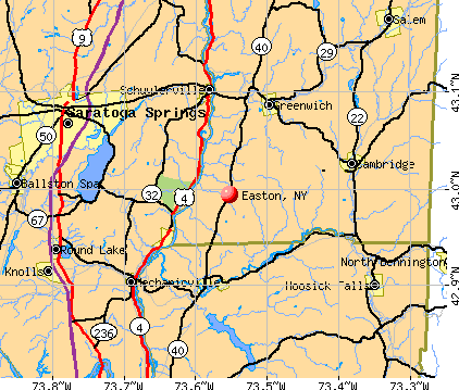
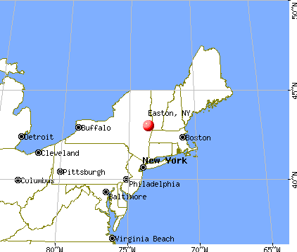
Easton, New York
Submit your own pictures of this town and show them to the world
- OSM Map
- General Map
- Google Map
- MSN Map
Population change since 2000: +3.4%
 |
| Males: 1,186 | |
| Females: 1,150 |
| Median resident age: | 43.4 years |
| New York median age: | 40.7 years |
Zip codes: 12834.
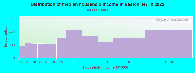
| Easton: | $77,011 |
| NY: | $79,557 |
Estimated per capita income in 2022: $38,322 (it was $19,998 in 2000)
Easton town income, earnings, and wages data
Estimated median house or condo value in 2022: $255,549 (it was $109,200 in 2000)
| Easton: | $255,549 |
| NY: | $400,400 |
Mean prices in 2022: all housing units: $230,821; detached houses: $233,893; townhouses or other attached units: $212,177; in 2-unit structures: $329,174; in 3-to-4-unit structures: over $1,000,000; in 5-or-more-unit structures: $895,403; mobile homes: $83,938
Detailed information about poverty and poor residents in Easton, NY


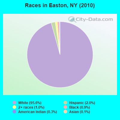
- 2,23495.6%White alone
- 472.0%Hispanic
- 231.0%Two or more races
- 220.9%Black alone
- 60.3%American Indian alone
- 30.1%Asian alone
- 10.04%Other race alone
Races in Easton detailed stats: ancestries, foreign born residents, place of birth
 Recent articles from our blog. Our writers, many of them Ph.D. graduates or candidates, create easy-to-read articles on a wide variety of topics.

 | Mr.Retired. Settling into my new digs. (168 replies) |
| Bills want new stadium to be completely funded by taxpayer money (998 replies) |
| Where to live an 1-2 hrs from NYC? (110 replies) |
| For those interested in Technology and Economic activity in Upstate NY... (2814 replies) |
| Safest Cities from natural disasters (70 replies) |
| Syracuse, NY Highly Rated and Ranked (43 replies) |
Latest news from Easton, NY collected exclusively by city-data.com from local newspapers, TV, and radio stations
Ancestries: Irish (16.9%), English (16.3%), German (13.0%), French (12.4%), Italian (10.7%), United States (7.8%).
Current Local Time: EST time zone
Elevation: 430 feet
Land area: 62.3 square miles.
Population density: 38 people per square mile (very low).
17 residents are foreign born
| This town: | 0.8% |
| New York: | 20.4% |
| Easton town: | 2.0% ($2,194) |
| New York: | 1.9% ($2,847) |
Nearest city with pop. 50,000+: Schenectady, NY  (25.3 miles , pop. 61,821).
Nearest city with pop. 200,000+: Boston, MA (133.8 miles , pop. 589,141).
Nearest city with pop. 1,000,000+: Bronx, NY (152.0 miles , pop. 1,332,650).
Nearest cities:
), ), )Latitude: 43.03 N, Longitude: 73.54 W
Area code commonly used in this area: 518
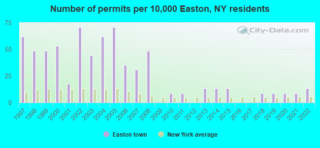
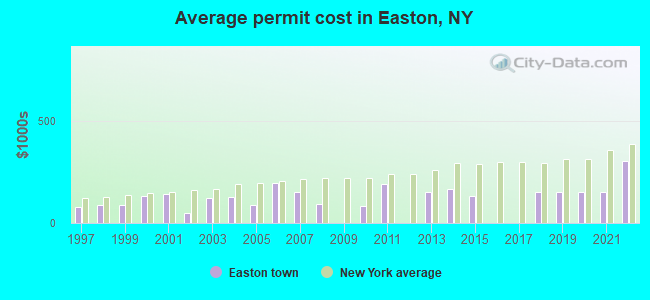
Single-family new house construction building permits:
- 2022: 3 buildings, average cost: $303,700
- 2021: 2 buildings, average cost: $150,000
- 2020: 2 buildings, average cost: $150,000
- 2019: 2 buildings, average cost: $150,000
- 2018: 2 buildings, average cost: $150,000
- 2015: 3 buildings, average cost: $133,300
- 2014: 3 buildings, average cost: $166,700
- 2013: 3 buildings, average cost: $151,700
- 2011: 2 buildings, average cost: $187,500
- 2010: 2 buildings, average cost: $82,500
- 2008: 11 buildings, average cost: $93,200
- 2007: 7 buildings, average cost: $150,000
- 2006: 8 buildings, average cost: $195,600
- 2005: 16 buildings, average cost: $88,100
- 2004: 14 buildings, average cost: $125,000
- 2003: 10 buildings, average cost: $124,000
- 2002: 16 buildings, average cost: $48,800
- 2001: 4 buildings, average cost: $139,700
- 2000: 12 buildings, average cost: $131,500
- 1999: 11 buildings, average cost: $90,000
- 1998: 11 buildings, average cost: $90,000
- 1997: 14 buildings, average cost: $80,000
| Here: | 4.1% |
| New York: | 4.4% |
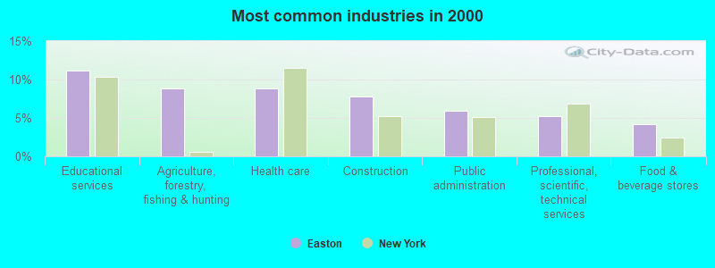
- Educational services (11.2%)
- Agriculture, forestry, fishing & hunting (8.9%)
- Health care (8.9%)
- Construction (7.8%)
- Public administration (5.9%)
- Professional, scientific, technical services (5.2%)
- Food & beverage stores (4.2%)
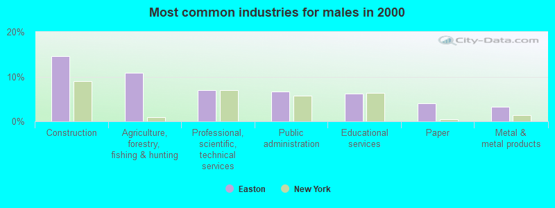
- Construction (14.6%)
- Agriculture, forestry, fishing & hunting (10.8%)
- Professional, scientific, technical services (7.0%)
- Public administration (6.6%)
- Educational services (6.3%)
- Paper (4.0%)
- Metal & metal products (3.3%)
- Health care (17.3%)
- Educational services (16.9%)
- Agriculture, forestry, fishing & hunting (6.7%)
- Accommodation & food services (6.5%)
- Food & beverage stores (5.2%)
- Public administration (5.0%)
- Finance & insurance (3.8%)
- Farmers and farm managers (5.4%)
- Other office and administrative support workers, including supervisors (4.8%)
- Preschool, kindergarten, elementary, and middle school teachers (4.7%)
- Cashiers (4.7%)
- Other management occupations, except farmers and farm managers (4.2%)
- Other production occupations, including supervisors (3.7%)
- Secretaries and administrative assistants (3.6%)
- Farmers and farm managers (7.8%)
- Vehicle and mobile equipment mechanics, installers, and repairers (5.6%)
- Other production occupations, including supervisors (5.2%)
- Metal workers and plastic workers (4.3%)
- Electrical equipment mechanics and other installation, maintenance, and repair workers, including supervisors (4.3%)
- Driver/sales workers and truck drivers (3.8%)
- Drafters, engineering, and mapping technicians (3.8%)
- Preschool, kindergarten, elementary, and middle school teachers (8.5%)
- Secretaries and administrative assistants (7.9%)
- Cashiers (7.5%)
- Other office and administrative support workers, including supervisors (6.0%)
- Nursing, psychiatric, and home health aides (5.4%)
- Other management occupations, except farmers and farm managers (4.8%)
- Supervisors and other personal care and service workers, except child care workers (4.2%)
Average climate in Easton, New York
Based on data reported by over 4,000 weather stations


(lower is better)
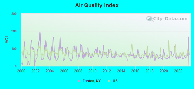
Air Quality Index (AQI) level in 2022 was 51.9. This is better than average.
| City: | 51.9 |
| U.S.: | 72.6 |
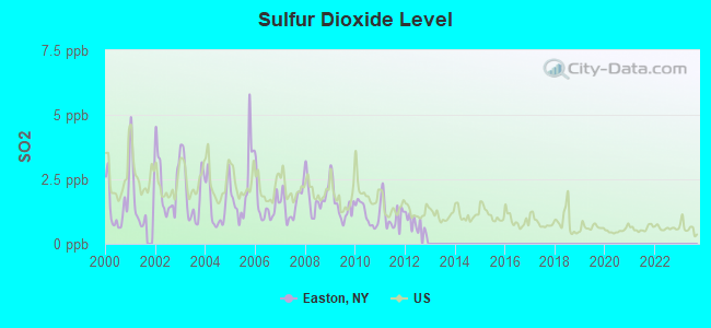
Sulfur Dioxide (SO2) [ppb] level in 2012 was 0.789. This is significantly better than average. Closest monitor was 17.6 miles away from the city center.
| City: | 0.789 |
| U.S.: | 1.515 |
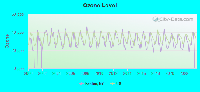
Ozone [ppb] level in 2022 was 29.1. This is about average. Closest monitor was 17.6 miles away from the city center.
| City: | 29.1 |
| U.S.: | 33.3 |
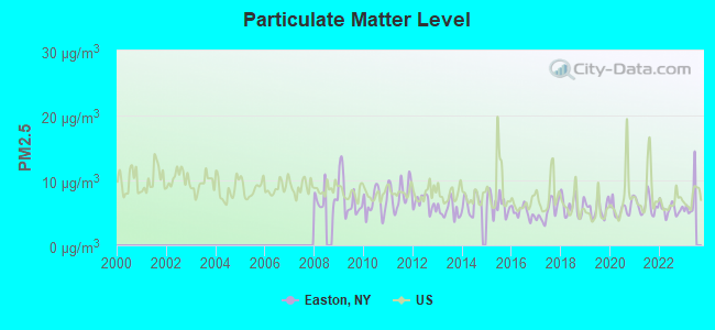
Particulate Matter (PM2.5) [µg/m3] level in 2022 was 5.56. This is significantly better than average. Closest monitor was 17.6 miles away from the city center.
| City: | 5.56 |
| U.S.: | 8.11 |
Tornado activity:
Easton-area historical tornado activity is slightly above New York state average. It is 52% smaller than the overall U.S. average.
On 6/24/1960, a category F3 (max. wind speeds 158-206 mph) tornado 12.4 miles away from the Easton town center injured 9 people and caused between $5,000,000 and $50,000,000 in damages.
On 5/31/1998, a category F3 tornado 14.0 miles away from the town center injured 68 people and caused $71 million in damages.
Earthquake activity:
Easton-area historical earthquake activity is significantly above New York state average. It is 68% smaller than the overall U.S. average.On 10/7/1983 at 10:18:46, a magnitude 5.3 (5.1 MB, 5.3 LG, 5.1 ML, Class: Moderate, Intensity: VI - VII) earthquake occurred 75.5 miles away from Easton center
On 4/20/2002 at 10:50:47, a magnitude 5.3 (5.3 ML, Depth: 3.0 mi) earthquake occurred 102.8 miles away from Easton center
On 4/20/2002 at 10:50:47, a magnitude 5.2 (5.2 MB, 4.2 MS, 5.2 MW, 5.0 MW) earthquake occurred 101.2 miles away from Easton center
On 1/19/1982 at 00:14:42, a magnitude 4.7 (4.5 MB, 4.7 MD, 4.5 LG, Class: Light, Intensity: IV - V) earthquake occurred 102.8 miles away from the city center
On 10/16/2012 at 23:12:25, a magnitude 4.7 (4.7 ML, Depth: 10.0 mi) earthquake occurred 150.2 miles away from the city center
On 6/17/1991 at 08:53:16, a magnitude 4.1 (4.0 MB, 4.0 LG, Depth: 3.1 mi) earthquake occurred 64.1 miles away from Easton center
Magnitude types: regional Lg-wave magnitude (LG), body-wave magnitude (MB), duration magnitude (MD), local magnitude (ML), surface-wave magnitude (MS), moment magnitude (MW)
Natural disasters:
The number of natural disasters in Washington County (14) is near the US average (15).Major Disasters (Presidential) Declared: 8
Emergencies Declared: 6
Causes of natural disasters: Floods: 3, Hurricanes: 3, Storms: 3, Winter Storms: 3, Blizzard: 1, Earthquake: 1, Power Outage: 1, Other: 2 (Note: some incidents may be assigned to more than one category).

Hospitals and medical centers near Easton:
- MARY MCCLELLAN HOSPITAL (Hospital, about 8 miles away; CAMBRIDGE, NY)
- THE CENTER FOR NURSING AND REHAB AT HOOSICK FALLS (Nursing Home, about 13 miles away; HOOSICK FALLS, NY)
- FOUR WINDS (Hospital, about 13 miles away; SARATOGA SPRINGS, NY)
- AIM SERVICES, INC (Hospital, about 14 miles away; SARATOGA SPRINGS, NY)
- SARATOGA CO PUB HLTH NURSNG HH (Home Health Center, about 14 miles away; SARATOGA SPRINGS, NY)
- SARATOGA COUNTY CHAPTER NYS ARC (Hospital, about 14 miles away; SARATOGA SPRINGS, NY)
- WESLEY HEALTH CARE CENTER (Nursing Home, about 14 miles away; SARATOGA SPRINGS, NY)
Amtrak stations near Easton:
- 15 miles: SARATOGA SPRINGS (WEST AVE. & STATION LN.) . Services: ticket office, partially wheelchair accessible, enclosed waiting area, public restrooms, public payphones, free short-term parking, free long-term parking, call for car rental service, call for taxi service, public transit connection.
- 17 miles: FORT EDWARD/GLENS FALLS (FORT EDWARD, EAST ST.) . Services: public payphones, free short-term parking, free long-term parking, call for car rental service, call for taxi service.
Colleges/universities with over 2000 students nearest to Easton:
- SUNY Empire State College (about 13 miles; Saratoga Springs, NY; Full-time enrollment: 9,473)
- Skidmore College (about 14 miles; Saratoga Springs, NY; FT enrollment: 2,753)
- Rensselaer Polytechnic Institute (about 23 miles; Troy, NY; FT enrollment: 6,940)
- The Sage Colleges (about 23 miles; Troy, NY; FT enrollment: 2,499)
- Adirondack Community College (about 24 miles; Queensbury, NY; FT enrollment: 2,826)
- Siena College (about 25 miles; Loudonville, NY; FT enrollment: 3,153)
- Hudson Valley Community College (about 25 miles; Troy, NY; FT enrollment: 9,346)
Points of interest:
Notable locations in Easton: Batten Kill Country Club (A), Borden's Orchard (B), Elihu Farm (C), R And R Farms (D), River Edge Farm (E), Skiff Farm (F), Edgewood Farm (G), Washington County Fairgrounds (H), Windy Hills Golf Course (I), Niagara-Mohawk Power Corporation Middle Falls Hydro Station (J), Easton Library (K), Easton Volunteer Fire Company (L). Display/hide their locations on the map
Church in Easton: Friends Church (A). Display/hide its location on the map
Cemetery: Brownell Cemetery (1). Display/hide its location on the map
Swamps: Fly Swamp (A). Display/hide its location on the map
Streams, rivers, and creeks: Fryer Brook (A), Flately Brook (B), Ensign Brook (C), Schuyler Brook (D), McAuley Brook (E), Kidney Creek (F). Display/hide their locations on the map
Birthplace of: George Henry Corliss - Mechanical engineer.
| This town: | 2.5 people |
| New York: | 2.6 people |
| This town: | 70.7% |
| Whole state: | 63.5% |
| This town: | 7.0% |
| Whole state: | 6.8% |
Likely homosexual households (counted as self-reported same-sex unmarried-partner households)
- Lesbian couples: 0.6% of all households
- Gay men: 0.3% of all households
| This town: | 6.6% |
| Whole state: | 14.6% |
| This town: | 2.5% |
| Whole state: | 7.4% |
11 people in other noninstitutional facilities in 2010
12 people in homes for the mentally retarded in 2000
For population 15 years and over in Easton:
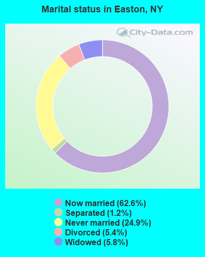
- Never married: 24.9%
- Now married: 62.6%
- Separated: 1.2%
- Widowed: 5.8%
- Divorced: 5.4%
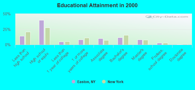
For population 25 years and over in Easton:
- High school or higher: 86.0%
- Bachelor's degree or higher: 23.0%
- Graduate or professional degree: 11.4%
- Unemployed: 4.3%
- Mean travel time to work (commute): 31.8 minutes
| Here: | 11.7 |
| New York average: | 14.2 |
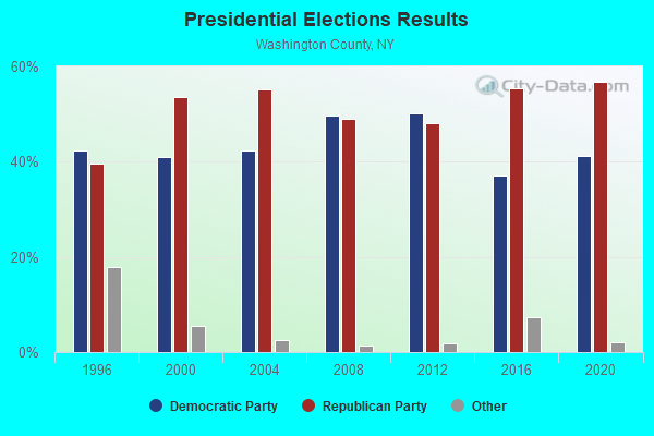
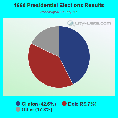
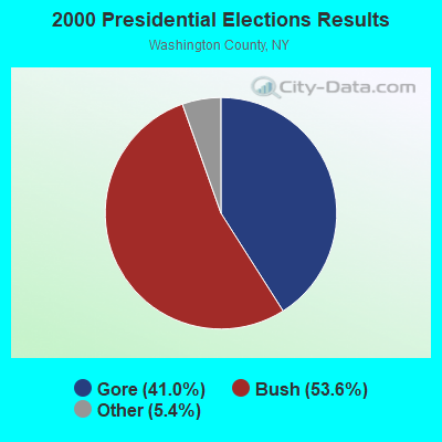
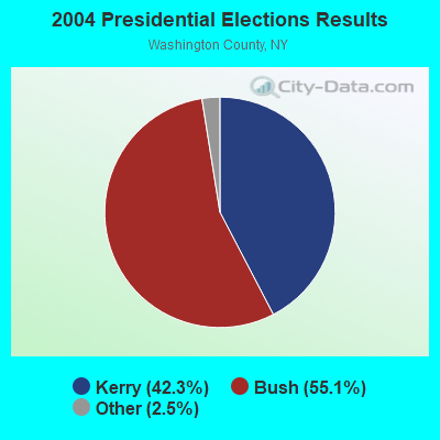
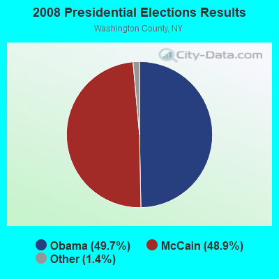

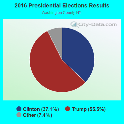
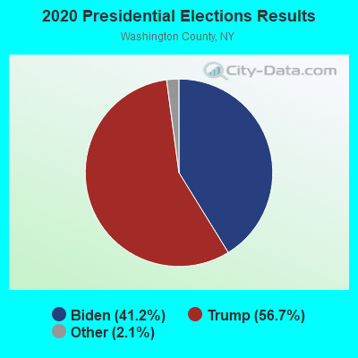
Graphs represent county-level data. Detailed 2008 Election Results
Religion statistics for Easton, NY (based on Washington County data)
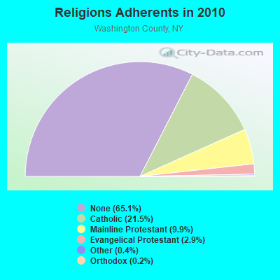
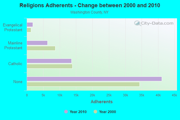
| Religion | Adherents | Congregations |
|---|---|---|
| Catholic | 13,581 | 10 |
| Mainline Protestant | 6,259 | 54 |
| Evangelical Protestant | 1,856 | 19 |
| Other | 256 | 4 |
| Orthodox | 140 | 3 |
| None | 41,124 | - |
Food Environment Statistics:
| Washington County: | 1.92 / 10,000 pop. |
| State: | 4.13 / 10,000 pop. |
| Washington County: | 4.32 / 10,000 pop. |
| New York: | 1.68 / 10,000 pop. |
| Washington County: | 7.51 / 10,000 pop. |
| New York: | 8.82 / 10,000 pop. |
| This county: | 8.1% |
| State: | 8.2% |
| Washington County: | 26.7% |
| New York: | 23.8% |
| Washington County: | 17.1% |
| New York: | 15.6% |
Strongest AM radio stations in Easton:
- WGY (810 AM; 50 kW; SCHENECTADY, NY; Owner: CLEAR CHANNEL BROADCASTING LICENSES, INC.)
- WPTR (1540 AM; 50 kW; ALBANY, NY; Owner: KIMTRON, INC.)
- WABY (1160 AM; 5 kW; MECHANICVILLE, NY; Owner: ANASTOS MEDIA GROUP, INC.)
- WNNZ (640 AM; 50 kW; WESTFIELD, MA; Owner: CLEAR CHANNEL BROADCASTING LICENSES, INC.)
- WOFX (980 AM; 5 kW; TROY, NY)
- WROW (590 AM; 5 kW; ALBANY, NY; Owner: 6 JOHNSON ROAD LICENSES, INC.)
- WCRN (830 AM; 50 kW; WORCESTER, MA; Owner: CARTER BROADCASTING CORPORATION)
- WTIC (1080 AM; 50 kW; HARTFORD, CT; Owner: INFINITY RADIO OPERATIONS INC.)
- WRKO (680 AM; 50 kW; BOSTON, MA; Owner: ENTERCOM BOSTON LICENSE, LLC)
- WVNE (760 AM; daytime; 25 kW; LEICESTER, MA; Owner: BLOUNT MASSCOM, INC.)
- WTMM (1300 AM; 5 kW; RENSSELAER, NY; Owner: REGENT LICENSEE OF MANSFIELD, INC.)
- WDDY (1460 AM; 5 kW; ALBANY, NY)
- WEEI (850 AM; 50 kW; BOSTON, MA; Owner: ENTERCOM BOSTON LICENSE, LLC)
Strongest FM radio stations in Easton:
- WEQX (102.7 FM; MANCHESTER, VT; Owner: NORTHSHIRE COMMUNICATIONS, INC.)
- WJAN (95.1 FM; SUNDERLAND, VT; Owner: 6 JOHNSON ROAD LICENSES, INC.)
- WNGN (91.9 FM; ARGYLE, NY; Owner: NORTHEAST GOSPEL BROADCASTING INC)
- WQAR (101.3 FM; STILLWATER, NY; Owner: ANASTOS MEDIA GROUP, INC.)
- WZEC (97.5 FM; HOOSICK FALLS, NY; Owner: GREAT NORTHERN RADIO, LLC)
- WAMC-FM (90.3 FM; ALBANY, NY; Owner: WAMC)
- WFFG-FM (107.1 FM; CORINTH, NY; Owner: VOX NEW YORK, L.L.C.)
- WVAY (100.7 FM; WILMINGTON, VT; Owner: GREAT NORTHERN RADIO, L.L.C.)
- WKBE (100.3 FM; WARRENSBURG, NY; Owner: 6 JOHNSON ROAD LICENSES, INC.)
- WKRD (93.7 FM; SCOTIA, NY; Owner: DOT COMMUNICATIONS, INC.)
- WCKM-FM (99.1 FM; LAKE GEORGE, NY; Owner: ENTERTRONICS, INC.)
- WNYQ (105.7 FM; QUEENSBURY, NY; Owner: VOX NEW YORK, L.L.C.)
- WCQL (95.9 FM; GLENS FALLS, NY; Owner: ENTERTRONICS, INC.)
- WBAR-FM (94.7 FM; LAKE LUZERNE, NY; Owner: CAPITAL MEDIA CORPORATION)
- WJJR (98.1 FM; RUTLAND, VT; Owner: 6 JOHNSON ROAD LICENSES, INC.)
- WZRT (97.1 FM; RUTLAND, VT; Owner: CAPSTAR TX LIMITED PARTNERSHIP)
- WEBK (105.3 FM; KILLINGTON, VT; Owner: 6 JOHNSON ROAD LICENSES, INC.)
- WGLV (91.7 FM; WOODSTOCK, VT; Owner: CHRISTIAN MINISTRIES INC)
- WSSK (89.7 FM; SARATOGA SPRINGS, NY; Owner: SOUND OF LIFE, INC.)
- WHDQ-FM1 (106.1 FM; RUTLAND, VT; Owner: GREAT NORTHERN RADIO, L.L.C.)
TV broadcast stations around Easton:
- WNYA-CA (Channel 39; EASTON, ETC., NY; Owner: VENTURE TECHNOLOGIES GROUP, LLC)
- WYPX (Channel 55; AMSTERDAM, NY; Owner: PAXSON ALBANY LICENSE, INC.)
- WNGN-LP (Channel 26; TROY, NY; Owner: BRIAN A. LARSON)
- National Bridge Inventory (NBI) Statistics
- 13Number of bridges
- 121ft / 36.5mTotal length
- $19,991,000Total costs
- 22,214Total average daily traffic
- 1,652Total average daily truck traffic
- 27,085Total future (year 2031) average daily traffic
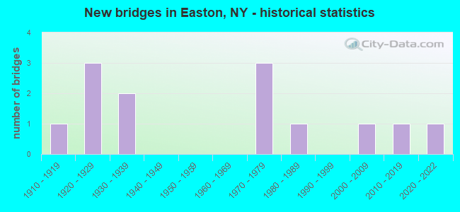
- New bridges - historical statistics
- 11910-1919
- 31920-1929
- 21930-1939
- 31970-1979
- 11980-1989
- 12000-2009
- 12010-2019
- 12020-2022
FCC Registered Cell Phone Towers:
1 (See the full list of FCC Registered Cell Phone Towers in Easton)FCC Registered Antenna Towers:
37 (See the full list of FCC Registered Antenna Towers)FCC Registered Private Land Mobile Towers:
2- Willard Mountain 1.5 Mi Ne Of (Lat: 43.020000 Lon: -73.523889), Type: Tower, Structure height: 30.5 m, Overall height: 34.7 m, Call Sign: WPDQ335,
Assigned Frequencies: 929.562 MHz, Grant Date: 10/24/1999, Expiration Date: 10/24/2009, Cancellation Date: 07/09/2001, Registrant: Paging Network Of America, Inc., 1500 International Pkwy, Suite 300, Richardson, TX 75081, Phone: (972) 801-0304, Fax: (972) 801-0330
- Sumit Of Willard Mtn (Lat: 43.020278 Lon: -73.524167), Type: Gtower, Structure height: 45.7 m, Call Sign: WQTG404,
Assigned Frequencies: 152.480 MHz, Grant Date: 01/28/2014, Expiration Date: 01/28/2024, Cancellation Date: 12/04/2023, Certifier: J. Roy Pottle, Registrant: Wilkinson Barker Knauer, LLP, 1800 M Street, N.W., Suite 800n, Washington, DC 20036, Phone: (202) 783-4141, Fax: (202) 783-5851, Email:
FCC Registered Broadcast Land Mobile Towers:
4- Willard Mtn (Lat: 43.020083 Lon: -73.524000), Call Sign: KNEH262,
Assigned Frequencies: 463.400 MHz, Grant Date: 02/19/2013, Expiration Date: 12/11/2022, Cancellation Date: 04/29/2023, Certifier: Stephen B Brown, Registrant: Washington Radio Reports, 1588 Fairfield Rd Ste 7, Gettysburg, PA 17325, Phone: (717) 334-0668, Fax: (717) 334-6440
- Willard Mt (Lat: 43.020083 Lon: -73.524000), Call Sign: WYS979, Licensee ID: L00139405,
Assigned Frequencies: 461.875 MHz, Grant Date: 02/14/2024, Expiration Date: 04/07/2034, Registrant: Adirondack 2-Way Radio Inc.
- Summit Of Willard Mtn (Lat: 43.020361 Lon: -73.523722), Call Sign: WNAB466,
Assigned Frequencies: 452.000 MHz, Grant Date: 06/02/1999, Expiration Date: 07/17/2004, Cancellation Date: 09/26/2004, Registrant: D A Collins Construction Co, Mechanicville, NY 12118, Phone: (518) 664-9855
- Willard Mountain 1.5 Mi. Ne Of (Lat: 43.020056 Lon: -73.524000), Type: Tower, Structure height: 30.5 m, Overall height: 34.7 m, Call Sign: WPVL947,
Assigned Frequencies: 856.237 MHz, 856.737 MHz, 858.737 MHz, Grant Date: 07/12/2002, Expiration Date: 07/12/2012, Cancellation Date: 11/17/2010, Certifier: Thomas J Cowper, Registrant: Nys Dhses Office Of Interoperable And Emergency Communications, State Office Campus Building 22, 1220 Washington Ave, Albany, NY 12226, Phone: (518) 322-4912, Fax: (518) 322-4975, Email:
FCC Registered Microwave Towers:
24 (See the full list of FCC Registered Microwave Towers in this town)FCC Registered Paging Towers:
3 (See the full list of FCC Registered Paging Towers)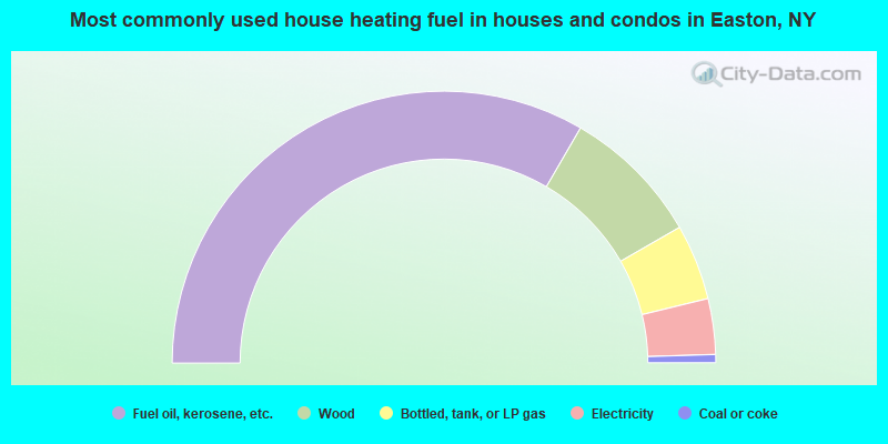
- 66.7%Fuel oil, kerosene, etc.
- 16.6%Wood
- 9.0%Bottled, tank, or LP gas
- 6.6%Electricity
- 1.0%Coal or coke
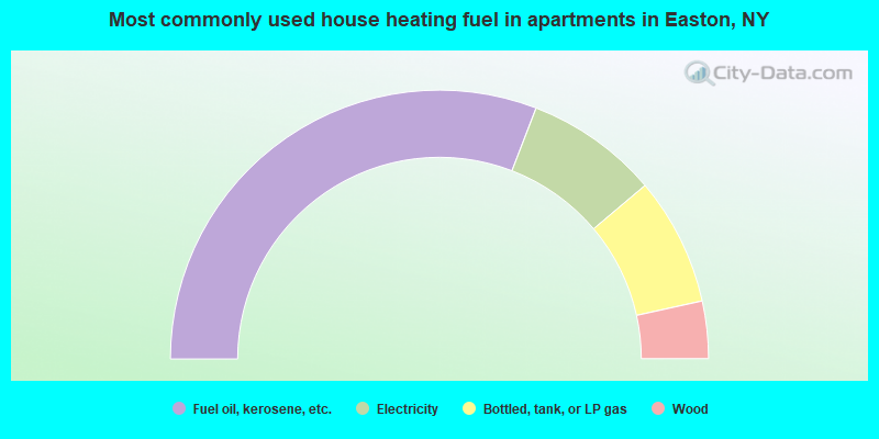
- 61.7%Fuel oil, kerosene, etc.
- 16.0%Electricity
- 15.4%Bottled, tank, or LP gas
- 6.9%Wood
Easton compared to New York state average:
- Median house value below state average.
- Unemployed percentage significantly below state average.
- Black race population percentage significantly below state average.
- Hispanic race population percentage significantly below state average.
- Foreign-born population percentage significantly below state average.
- Renting percentage significantly below state average.
- Length of stay since moving in significantly above state average.
- Number of rooms per house significantly below state average.
- House age significantly below state average.
- Number of college students below state average.