Bridge Statistics for Easton, New York (NY)
Condition, Traffic, Stress, Structural Evaluation, Project Costs
- National Bridge Inventory (NBI) Statistics
- 13Number of bridges
- 121ft / 36.5mTotal length
- $19,991,000Total costs
- 22,214Total average daily traffic
- 1,652Total average daily truck traffic
- 27,085Total future (year 2031) average daily traffic
- National Bridge Inventory (NBI) Registered Bridges for Easton
- No street view available for this location
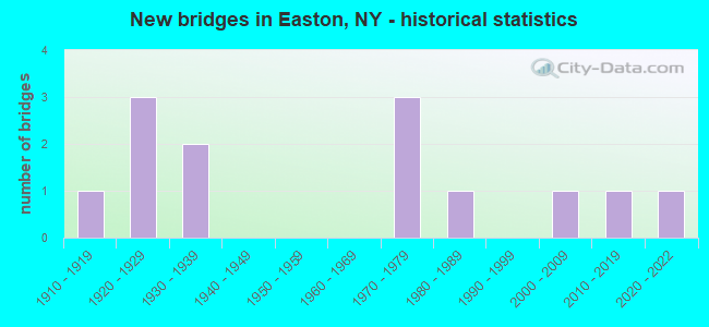
- New bridges - historical statistics
- 11910-1919
- 31920-1929
- 21930-1939
- 31970-1979
- 11980-1989
- 12000-2009
- 12010-2019
- 12020-2022

- Reconstructed bridges - Historical Statistics
- 41980-1989
- 21990-1999


- Bridge Condition - Deck
- 10.0%Excellent
- 20.0%Good
- 40.0%Satisfactory
- 30.0%Fair

- Bridge Condition - Superstructure
- 18.2%Excellent
- 36.4%Very good
- 18.2%Good
- 9.1%Fair
- 18.2%Poor

- Bridge Condition - Substructure
- 18.2%Excellent
- 9.1%Very good
- 9.1%Good
- 9.1%Satisfactory
- 27.3%Fair
- 27.3%Poor

- Bridge Condition - Channel
- 8.3%Excellent
- 8.3%Very good
- 8.3%Good
- 25.0%Satisfactory
- 25.0%Fair
- 25.0%Poor
Find on map >> Show street view
Structure Number: 102071, Location: .2 MI N JCT SH 29 & SH 40 (Lat: 43.095978, Lng: -73.525817), Route carried "on" structure: State highway 29, Year Built: 2003, Status: Open, Structure Length: 2.29m (7.51ft), Average Daily Traffic: 7,179 (year 2018), Truck Traffic: 8%, Average Future Daily Traffic: 8,043 (year 2040), Design Load: HS 25 or greater, Features Intersected: BATTENKILL RAILROAD
Minimum Vertical Clearance: 30+ m (98+ ft), Kilometerpoint: 4.135, Lanes on structure: 2, Base Highway Network: Yes, Owner: State Highway Agency, Approaching Roadway Width: 11.3m (37.1ft), Material/Design: Steel, Design/Construction: Stringer/Multi-beam, Number Of Spans In Main Unit: 1, Length of Maximum Span: 21.3m (69.9ft), Curb-To-Curb Width: 11.4m (37.4ft), Out-to-Out Width: 12.4m (40.7ft)
Condition: Deck: Satisfactory, Superstructure: Very good, Substructure: Very good, Operating Rating: 77.1 metric tons, Method Used To Determine Operating Rating: Load Factor (LF), Inventory Rating: 46.3 metric tons, Method Used To Determine Inventory Rating: Load Factor (LF), Structural Evaluation: Equal to present desirable criteria, Deck Geometry: Meets minimum limits, Underclear: Superior to present desirable criteria, Approach Roadway Alignment: Equal to present desirable criteria, Length Of Structure Improvement: 2.28m (7.48ft), Designated Inspection Frequency: Every 24 months, Inspection Date: March 2021, Bridge Improvement Cost: $698,000, Roadway Improvement Cost: $409,000, Total Project Cost: $1,107,000 ( Estimate for 2021), Deck Structure Type: Concrete Cast-file-Place, Wearing Surface/Protective System: Wearing Surface: Monolithic Concrete, Deck Protection: Epoxy Coated Reinforcing
Find on map >> Show street view
Structure Number: 102072, Location: RTE 29<40 OVER BATTEN KIL (Lat: 43.098969, Lng: -73.525039), Route carried "on" structure: State highway 29, Year Built: 2020, Status: Open, Structure Length: 6.64m (21.78ft), Average Daily Traffic: 7,179 (year 2018), Truck Traffic: 8%, Average Future Daily Traffic: 8,043 (year 2040), Design Load: HL 93, Features Intersected: BATTEN KILL
Minimum Vertical Clearance: 30+ m (98+ ft), Kilometerpoint: 4.457, Lanes on structure: 2, Base Highway Network: Yes, Owner: State Highway Agency, Approaching Roadway Width: 11.6m (38.1ft), Material/Design: Steel, Design/Construction: Stringer/Multi-beam, Number Of Spans In Main Unit: 1, Length of Maximum Span: 65.8m (215.9ft), Curb or Sidewalk Widths: Left: 1.5m (4.9ft), Right: 0.0m, Curb-To-Curb Width: 10.1m (33.1ft), Out-to-Out Width: 12.6m (41.3ft)
Condition: Deck: Excellent, Superstructure: Excellent, Substructure: Excellent, Channel: Very good, Operating Rating: 79.8 metric tons, Method Used To Determine Operating Rating: Load Factor (LF), Inventory Rating: 48.1 metric tons, Method Used To Determine Inventory Rating: Load Factor (LF), Structural Evaluation: Superior to present desirable criteria, Deck Geometry: Meets minimum limits, Waterway Adequacy: Equal to present minimum criteria, Approach Roadway Alignment: Equal to present desirable criteria, Length Of Structure Improvement: 5.54m (18.18ft), Designated Inspection Frequency: Every 24 months, Inspection Date: June 2021, Bridge Improvement Cost: $2,482,000, Roadway Improvement Cost: $1,454,000, Total Project Cost: $3,936,000 ( Estimate for 2021), Wearing Surface/Protective System: Wearing Surface: Monolithic Concrete, Membrane: Other
Find on map >> Show street view
Structure Number: 220362, Location: 2 MI S GREENWICH (Lat: 43.043494, Lng: -73.497419), Route carried "on" structure: Other road , Year Built: 1971, Status: Posted for load, Structure Length: 0.73m (2.40ft), Average Daily Traffic: 174 (year 2017), Truck Traffic: 6%, Average Future Daily Traffic: 244 (year 2037), Design Load: H 20, Features Intersected: FLY CREEK, Facility Carried by Structure: EASTON STATION RD
Minimum Vertical Clearance: 30+ m (98+ ft), Kilometerpoint: 2.237, Lanes on structure: 2, Owner: Town or Township Highway Agency, Approaching Roadway Width: 6.7m (22.0ft), Material/Design: Steel, Design/Construction: Stringer/Multi-beam, Number Of Spans In Main Unit: 1, Length of Maximum Span: 6.7m (22.0ft), Curb-To-Curb Width: 7.0m (23.0ft), Out-to-Out Width: 7.1m (23.3ft)
Condition: Deck: Fair, Superstructure: Fair, Substructure: Satisfactory, Channel: Fair, Operating Rating: 78.9 metric tons, Method Used To Determine Operating Rating: Load Factor (LF), Inventory Rating: 47.2 metric tons, Method Used To Determine Inventory Rating: Load Factor (LF), Structural Evaluation: Somewhat better than minimum adequacy, Deck Geometry: Meets minimum limits, Waterway Adequacy: Better than present minimum criteria, Approach Roadway Alignment: Somewhat better than minimum adequacy, Bridge Posting: Required (Relationship of Operating Rating to Maximum Legal Load: > 39.9% below), Length Of Structure Improvement: 0.73m (2.40ft), Designated Inspection Frequency: Every 12 months, Inspection Date: May 2021, Bridge Improvement Cost: $198,000, Roadway Improvement Cost: $116,000, Total Project Cost: $315,000 ( Estimate for 2021), Deck Structure Type: Concrete Cast-file-Place, Wearing Surface/Protective System: Wearing Surface: Bituminous
Find on map >> Show street view
Structure Number: 225734, Location: 2 MI S OF GREENWICH (Lat: 43.072325, Lng: -73.495531), Route carried "on" structure: Other road , Year Built: 1976, Status: Open, Structure Length: 0.76m (2.49ft), Average Daily Traffic: 137 (year 2017), Truck Traffic: 6%, Average Future Daily Traffic: 192 (year 2037), Features Intersected: FLY CREEK, Facility Carried by Structure: COL.BAUME ROAD
Minimum Vertical Clearance: 30+ m (98+ ft), Kilometerpoint: 0.048, Lanes on structure: 2, Owner: Town or Township Highway Agency, Approaching Roadway Width: 6.1m (20.0ft), Skew: 4 degrees, Material/Design: Steel, Design/Construction: Culvert, Number Of Spans In Main Unit: 2, Length of Maximum Span: 3.6m (11.8ft)
Condition: Channel: Poor, Culverts: Satisfactory, Operating Rating: 74.1 metric tons, Method Used To Determine Operating Rating: Field evaluation and documented engineering judgment, Inventory Rating: 19.6 metric tons, Method Used To Determine Inventory Rating: Field evaluation and documented engineering judgment, Structural Evaluation: Somewhat better than minimum adequacy, Waterway Adequacy: Meets minimum limits, Approach Roadway Alignment: Equal to present minimum criteria, Length Of Structure Improvement: 0.76m (2.49ft), Designated Inspection Frequency: Every 24 months, Inspection Date: May 2020, Bridge Improvement Cost: $82,000, Roadway Improvement Cost: $48,000, Total Project Cost: $130,000 ( Estimate for 2021), Wearing Surface/Protective System: Wearing Surface: Bituminous
Find on map >> Show street view
Structure Number: 330585, Location: 6.7 MI S JCT RTS 4 + 29 (Lat: 43.001917, Lng: -73.591653), Route carried "on" structure: County highway , Year Built: 1929, Year Reconstructed: 1987, Status: Open, Structure Length: 0.98m (3.22ft), Average Daily Traffic: 531 (year 2018), Truck Traffic: 7%, Average Future Daily Traffic: 743 (year 2038), Features Intersected: MCAULEY BROOK, Facility Carried by Structure: CR 113, RIVER ROAD
Minimum Vertical Clearance: 30+ m (98+ ft), Kilometerpoint: 7.691, Lanes on structure: 2, Owner: County Highway Agency, Approaching Roadway Width: 7.3m (24.0ft), Material/Design: Steel, Design/Construction: Stringer/Multi-beam, Number Of Spans In Main Unit: 1, Length of Maximum Span: 8.8m (28.9ft), Curb-To-Curb Width: 7.3m (24.0ft), Out-to-Out Width: 7.9m (25.9ft)
Condition: Deck: Fair, Superstructure: Good, Substructure: Poor, Channel: Satisfactory, Operating Rating: 81.3 metric tons, Method Used To Determine Operating Rating: Load and Resistance Factor Rating (LRFR) rating reported by rating factor(RF) method using HL-93 loadings, Inventory Rating: 62.9 metric tons, Method Used To Determine Inventory Rating: Load and Resistance Factor Rating (LRFR) rating reported by rating factor(RF) method using HL-93 loadings, Structural Evaluation: Meets minimum limits, Deck Geometry: Meets minimum limits, Waterway Adequacy: Superior to present desirable criteria, Approach Roadway Alignment: Meets minimum limits, Length Of Structure Improvement: 0.97m (3.18ft), Designated Inspection Frequency: Every 24 months, Inspection Date: August 2021, Bridge Improvement Cost: $240,000, Roadway Improvement Cost: $140,000, Total Project Cost: $380,000 ( Estimate for 2021), Deck Structure Type: Concrete Cast-file-Place, Wearing Surface/Protective System: Wearing Surface: Integral Concrete
Find on map >> Show street view
Structure Number: 330587, Location: 4.9 MI S JCT RTS 4 + 29 (Lat: 43.026408, Lng: -73.583525), Route carried "on" structure: County highway , Year Built: 1929, Year Reconstructed: 1986, Status: Open, Structure Length: 0.91m (2.99ft), Average Daily Traffic: 455 (year 2018), Truck Traffic: 8%, Average Future Daily Traffic: 637 (year 2038), Features Intersected: ENSIGN BROOK, Facility Carried by Structure: CR 113, RIVER ROAD
Minimum Vertical Clearance: 30+ m (98+ ft), Kilometerpoint: 10.587, Lanes on structure: 2, Owner: County Highway Agency, Approaching Roadway Width: 7.3m (24.0ft), Material/Design: Steel, Design/Construction: Stringer/Multi-beam, Number Of Spans In Main Unit: 1, Length of Maximum Span: 8.5m (27.9ft), Curb-To-Curb Width: 7.3m (24.0ft), Out-to-Out Width: 7.9m (25.9ft)
Condition: Deck: Fair, Superstructure: Very good, Substructure: Poor, Channel: Fair, Inventory Rating: 85.3 metric tons, Method Used To Determine Inventory Rating: Load Factor (LF), Structural Evaluation: Meets minimum limits, Deck Geometry: Meets minimum limits, Waterway Adequacy: Superior to present desirable criteria, Approach Roadway Alignment: Meets minimum limits, Length Of Structure Improvement: 0.91m (2.99ft), Designated Inspection Frequency: Every 24 months, Inspection Date: August 2021, Bridge Improvement Cost: $249,000, Roadway Improvement Cost: $146,000, Total Project Cost: $395,000 ( Estimate for 2021), Deck Structure Type: Concrete Cast-file-Place, Wearing Surface/Protective System: Wearing Surface: Integral Concrete
Find on map >> Show street view
Structure Number: 330588, Location: 3.3 MI S JCT RTS 4 + 29 (Lat: 43.047061, Lng: -73.578617), Route carried "on" structure: County highway , Year Built: 1929, Year Reconstructed: 1986, Status: Open, Structure Length: 0.94m (3.08ft), Average Daily Traffic: 455 (year 2018), Truck Traffic: 8%, Average Future Daily Traffic: 637 (year 2038), Features Intersected: FLATELY BROOK, Facility Carried by Structure: CR 113, RIVER ROAD
Minimum Vertical Clearance: 30+ m (98+ ft), Kilometerpoint: 12.936, Lanes on structure: 2, Owner: County Highway Agency, Approaching Roadway Width: 7.3m (24.0ft), Skew: 3 degrees, Material/Design: Steel, Design/Construction: Stringer/Multi-beam, Number Of Spans In Main Unit: 1, Length of Maximum Span: 8.8m (28.9ft), Curb-To-Curb Width: 7.3m (24.0ft), Out-to-Out Width: 7.9m (25.9ft)
Condition: Deck: Good, Superstructure: Good, Substructure: Fair, Channel: Satisfactory, Operating Rating: 84.6 metric tons, Method Used To Determine Operating Rating: Load and Resistance Factor Rating (LRFR) rating reported by rating factor(RF) method using HL-93 loadings, Inventory Rating: 65.1 metric tons, Method Used To Determine Inventory Rating: Load and Resistance Factor Rating (LRFR) rating reported by rating factor(RF) method using HL-93 loadings, Structural Evaluation: Somewhat better than minimum adequacy, Deck Geometry: Meets minimum limits, Waterway Adequacy: Superior to present desirable criteria, Approach Roadway Alignment: Meets minimum limits, Length Of Structure Improvement: 0.94m (3.08ft), Designated Inspection Frequency: Every 24 months, Inspection Date: August 2021, Bridge Improvement Cost: $271,000, Roadway Improvement Cost: $159,000, Total Project Cost: $429,000 ( Estimate for 2021), Deck Structure Type: Concrete Cast-file-Place, Wearing Surface/Protective System: Wearing Surface: Integral Concrete
Find on map >> Show street view
Structure Number: 330593, Location: 2.2 MI NE JCT RTS 4 + 67 (Lat: 42.957369, Lng: -73.623256), Route carried "on" structure: County highway , Year Built: 1930, Year Reconstructed: 1998, Status: Open, Structure Length: 0.76m (2.49ft), Average Daily Traffic: 1,032 (year 2020), Truck Traffic: 7%, Average Future Daily Traffic: 1,445 (year 2040), Design Load: H 20, Features Intersected: UNKNOWN STREAM, Facility Carried by Structure: CR 113, RIVER ROAD
Minimum Vertical Clearance: 30+ m (98+ ft), Kilometerpoint: 1.995, Lanes on structure: 2, Owner: County Highway Agency, Approaching Roadway Width: 7.3m (24.0ft), Skew: 3 degrees, Material/Design: Steel, Design/Construction: Stringer/Multi-beam, Number Of Spans In Main Unit: 1, Length of Maximum Span: 6.4m (21.0ft), Curb-To-Curb Width: 7.4m (24.3ft), Out-to-Out Width: 7.9m (25.9ft)
Condition: Deck: Satisfactory, Superstructure: Very good, Substructure: Fair, Channel: Poor, Operating Rating: 97.2 metric tons, Method Used To Determine Operating Rating: Load and Resistance Factor Rating (LRFR) rating reported by rating factor(RF) method using HL-93 loadings, Inventory Rating: 79.1 metric tons, Method Used To Determine Inventory Rating: Load and Resistance Factor Rating (LRFR) rating reported by rating factor(RF) method using HL-93 loadings, Structural Evaluation: Somewhat better than minimum adequacy, Deck Geometry: Meets minimum limits, Waterway Adequacy: Better than present minimum criteria, Approach Roadway Alignment: Somewhat better than minimum adequacy, Length Of Structure Improvement: 0.76m (2.49ft), Designated Inspection Frequency: Every 24 months, Inspection Date: August 2021, Bridge Improvement Cost: $328,000, Roadway Improvement Cost: $192,000, Total Project Cost: $520,000 ( Estimate for 2021), Deck Structure Type: Concrete Cast-file-Place, Wearing Surface/Protective System: Wearing Surface: Integral Concrete
Find on map >> Show street view
Structure Number: 330615, Location: 3.2MI W OF CAMBRIDGE (Lat: 43.043492, Lng: -73.496936), Route carried "on" structure: County highway , Year Built: 1936, Year Reconstructed: 1990, Status: Open, Structure Length: 0.73m (2.40ft), Average Daily Traffic: 743 (year 2016), Truck Traffic: 6%, Average Future Daily Traffic: 1,040 (year 2036), Design Load: H 20, Features Intersected: FLY CREEK, Facility Carried by Structure: CR 74, RAIL ROAD
Minimum Vertical Clearance: 30+ m (98+ ft), Kilometerpoint: 12.711, Lanes on structure: 2, Owner: County Highway Agency, Approaching Roadway Width: 10.4m (34.1ft), Material/Design: Steel, Design/Construction: Stringer/Multi-beam, Number Of Spans In Main Unit: 1, Length of Maximum Span: 7.0m (23.0ft), Curb-To-Curb Width: 10.4m (34.1ft), Out-to-Out Width: 11.0m (36.1ft)
Condition: Deck: Satisfactory, Superstructure: Poor, Substructure: Poor, Channel: Fair, Operating Rating: 79.8 metric tons, Method Used To Determine Operating Rating: Load Factor (LF), Inventory Rating: 48.1 metric tons, Method Used To Determine Inventory Rating: Load Factor (LF), Structural Evaluation: Meets minimum limits, Deck Geometry: Equal to present minimum criteria, Waterway Adequacy: Better than present minimum criteria, Approach Roadway Alignment: Better than present minimum criteria, Length Of Structure Improvement: 0.73m (2.40ft), Designated Inspection Frequency: Every 24 months, Inspection Date: May 2021, Bridge Improvement Cost: $230,000, Roadway Improvement Cost: $134,000, Total Project Cost: $364,000 ( Estimate for 2021), Deck Structure Type: Wood or Timber, Wearing Surface/Protective System: Wearing Surface: Bituminous
Find on map >> Show street view
Structure Number: 330617, Location: 1 MI S OF GREENWICH (Lat: 43.070256, Lng: -73.497750), Route carried "on" structure: County highway , Year Built: 1912, Year Reconstructed: 1989, Status: Open, Structure Length: 0.88m (2.89ft), Average Daily Traffic: 645 (year 2018), Truck Traffic: 5%, Average Future Daily Traffic: 903 (year 2038), Features Intersected: FLY CREEK, Facility Carried by Structure: COUNTY ROAD 74
Minimum Vertical Clearance: 30+ m (98+ ft), Kilometerpoint: 15.913, Lanes on structure: 2, Owner: County Highway Agency, Approaching Roadway Width: 7.9m (25.9ft), Material/Design: Steel, Design/Construction: Stringer/Multi-beam, Number Of Spans In Main Unit: 1, Length of Maximum Span: 8.2m (26.9ft), Curb-To-Curb Width: 7.9m (25.9ft), Out-to-Out Width: 8.6m (28.2ft)
Condition: Deck: Satisfactory, Superstructure: Poor, Substructure: Fair, Channel: Poor, Inventory Rating: 61.7 metric tons, Method Used To Determine Inventory Rating: Load Factor (LF), Structural Evaluation: Meets minimum limits, Deck Geometry: Somewhat better than minimum adequacy, Waterway Adequacy: Better than present minimum criteria, Approach Roadway Alignment: Better than present minimum criteria, Length Of Structure Improvement: 0.88m (2.89ft), Designated Inspection Frequency: Every 24 months, Inspection Date: May 2021, Bridge Improvement Cost: $265,000, Roadway Improvement Cost: $155,000, Total Project Cost: $420,000 ( Estimate for 2021), Deck Structure Type: Wood or Timber, Wearing Surface/Protective System: Wearing Surface: Bituminous
Find on map >> Show street view
Structure Number: 330635, Location: 1 MI. W. OF GREENWICH (Lat: 43.088931, Lng: -73.521264), Route carried "on" structure: Other road , Year Built: 1987, Status: Open, Structure Length: 11.67m (38.29ft), Average Daily Traffic: 2,129 (year 2017), Truck Traffic: 5%, Average Future Daily Traffic: 2,981 (year 2037), Design Load: HS 20, Features Intersected: BATTEN KILL, Facility Carried by Structure: HEGEMAN BRIDGE RD
Minimum Vertical Clearance: 30+ m (98+ ft), Kilometerpoint: 0.853, Lanes on structure: 2, Owner: County Highway Agency, Approaching Roadway Width: 8.5m (27.9ft), Material/Design: Steel continuous, Design/Construction: Stringer/Multi-beam, Number Of Spans In Main Unit: 3, Length of Maximum Span: 44.8m (147.0ft), Curb-To-Curb Width: 8.5m (27.9ft), Out-to-Out Width: 9.1m (29.9ft)
Condition: Deck: Good, Superstructure: Very good, Substructure: Good, Channel: Good, Operating Rating: 71.7 metric tons, Method Used To Determine Operating Rating: Load Factor (LF), Inventory Rating: 42.6 metric tons, Method Used To Determine Inventory Rating: Load Factor (LF), Structural Evaluation: Better than present minimum criteria, Deck Geometry: Meets minimum limits, Waterway Adequacy: Superior to present desirable criteria, Approach Roadway Alignment: Equal to present desirable criteria, Length Of Structure Improvement: 11.67m (38.29ft), Designated Inspection Frequency: Every 24 months, Inspection Date: July 2020, Bridge Improvement Cost: $2,357,000, Roadway Improvement Cost: $1,380,000, Total Project Cost: $3,737,000 ( Estimate for 2021), Deck Structure Type: Concrete Cast-file-Place, Wearing Surface/Protective System: Wearing Surface: Integral Concrete, Deck Protection: Epoxy Coated Reinforcing
Find on map >> Show street view
Structure Number: 330636, Location: IN CLARKS MILLS (Lat: 43.115467, Lng: -73.568047), Route carried "on" structure: County highway , Year Built: 2019, Status: Open, Structure Length: 8.53m (27.99ft), Average Daily Traffic: 772 (year 2017), Truck Traffic: 9%, Average Future Daily Traffic: 1,081 (year 2037), Design Load: HL 93, Features Intersected: BATTEN KILL, Facility Carried by Structure: COUNTY ROAD 113
Minimum Vertical Clearance: 30+ m (98+ ft), Kilometerpoint: 20.853, Lanes on structure: 2, Owner: County Highway Agency, Approaching Roadway Width: 10.7m (35.1ft), Material/Design: Concrete, Design/Construction: Arch - Deck, Number Of Spans In Main Unit: 3, Length of Maximum Span: 26.8m (87.9ft), Curb or Sidewalk Widths: Left: 0.0m, Right: 1.7m (5.6ft), Curb-To-Curb Width: 9.8m (32.2ft), Out-to-Out Width: 12.4m (40.7ft)
Condition: Superstructure: Excellent, Substructure: Excellent, Channel: Excellent, Operating Rating: 91.7 metric tons, Method Used To Determine Operating Rating: Field evaluation and documented engineering judgment, Inventory Rating: 40.8 metric tons, Method Used To Determine Inventory Rating: Field evaluation and documented engineering judgment, Structural Evaluation: Superior to present desirable criteria, Deck Geometry: Equal to present minimum criteria, Waterway Adequacy: Equal to present minimum criteria, Approach Roadway Alignment: Better than present minimum criteria, Length Of Structure Improvement: 8.53m (27.99ft), Designated Inspection Frequency: Every 24 months, Inspection Date: May 2020, Bridge Improvement Cost: $5,074,000, Roadway Improvement Cost: $2,972,000, Total Project Cost: $8,046,000 ( Estimate for 2021), Wearing Surface/Protective System: Wearing Surface: Bituminous
Find on map >> Show street view
Structure Number: 33068, Location: 4.2 MI NE OF STILLWATER (Lat: 42.980428, Lng: -73.609056), Route carried "on" structure: County highway , Year Built: 1977, Status: Open, Structure Length: 0.73m (2.40ft), Average Daily Traffic: 783 (year 2011), Truck Traffic: 7%, Average Future Daily Traffic: 1,096 (year 2031), Design Load: HS 20, Features Intersected: KIDNEY CREEK, Facility Carried by Structure: COUNTY ROAD 113
Minimum Vertical Clearance: 30+ m (98+ ft), Kilometerpoint: 4.875, Lanes on structure: 2, Owner: County Highway Agency, Approaching Roadway Width: 10.4m (34.1ft), Material/Design: Steel, Design/Construction: Culvert, Number Of Spans In Main Unit: 1, Length of Maximum Span: 7.0m (23.0ft)
Condition: Channel: Satisfactory, Culverts: Satisfactory, Operating Rating: 77.6 metric tons, Method Used To Determine Operating Rating: Field evaluation and documented engineering judgment, Inventory Rating: 32.7 metric tons, Method Used To Determine Inventory Rating: Field evaluation and documented engineering judgment, Structural Evaluation: Equal to present minimum criteria, Waterway Adequacy: Meets minimum limits, Approach Roadway Alignment: Equal to present desirable criteria, Length Of Structure Improvement: 0.73m (2.40ft), Designated Inspection Frequency: Every 24 months, Inspection Date: April 2021, Bridge Improvement Cost: $134,000, Roadway Improvement Cost: $78,000, Total Project Cost: $212,000 ( Estimate for 2021)