Bridge Statistics for Tulare, California (CA)
Condition, Traffic, Stress, Structural Evaluation, Project Costs
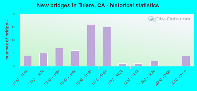
- New bridges - historical statistics
- 41910-1919
- 51920-1929
- 71930-1939
- 61940-1949
- 161950-1959
- 151960-1969
- 11970-1979
- 11980-1989
- 21990-1999
- 42010-2019

- Reconstructed bridges - Historical Statistics
- 11940-1949
- 21950-1959
- 41960-1969
- 21970-1979
- 11980-1989
- 21990-1999
- 32000-2009


- Bridge Condition - Deck
- 73.3%Good
- 3.3%Satisfactory
- 23.3%Fair

- Bridge Condition - Superstructure
- 86.7%Good
- 13.3%Fair

- Bridge Condition - Substructure
- 60.0%Good
- 36.7%Fair
- 3.3%Poor

- Bridge Condition - Channel
- 5.7%Very good
- 62.9%Good
- 25.7%Satisfactory
- 2.9%Fair
- 2.9%Poor

- Bridge Condition - Culverts
- 33.3%Good
- 55.6%Satisfactory
- 11.1%Fair
Find on map >> Show street view
Structure Number: 46 0041, Location: 06-TUL-198-R19.01 (Lat: 36.326161, Lng: -119.130492), Route carried "on" structure: State highway 198, Year Built: 1965, Status: Open, Structure Length: 3.90m (12.80ft), Average Daily Traffic: 11,600 (year 2009), Truck Traffic: 11%, Average Future Daily Traffic: 28,732 (year 2041), Design Load: HS 20+Mod, Features Intersected: TVRR SPUR
Minimum Vertical Clearance: 30+ m (98+ ft), Kilometerpoint: 19.010, Lanes on structure: 4, Base Highway Network: Yes (Inventory Route: 1, Subroute: 1), Owner: State Highway Agency, Approaching Roadway Width: 26.2m (86.0ft), Skew: 30 degrees, Material/Design: Concrete continuous, Design/Construction: Tee Beam, Number Of Spans In Main Unit: 3, Length of Maximum Span: 12.8m (42.0ft), Curb-To-Curb Width: 26.0m (85.3ft), Out-to-Out Width: 27.0m (88.6ft)
Condition: Deck: Good, Superstructure: Good, Substructure: Good, Operating Rating: 34.0 metric tons, Method Used To Determine Operating Rating: Load and Resistance Factor Rating (LRFR) rating reported by rating factor(RF) method using HL-93 loadings, Inventory Rating: 26.2 metric tons, Method Used To Determine Inventory Rating: Load and Resistance Factor Rating (LRFR) rating reported by rating factor(RF) method using HL-93 loadings, Structural Evaluation: Equal to present minimum criteria, Deck Geometry: Superior to present desirable criteria, Approach Roadway Alignment: Equal to present desirable criteria, Designated Inspection Frequency: Every 24 months, Inspection Date: January 2021, Deck Structure Type: Concrete Cast-file-Place, Wearing Surface/Protective System: Wearing Surface: Integral Concrete
Find on map >> Show street view
Structure Number: 46 0053Y, Location: 06-TUL-099-32.90 (Lat: 36.255061, Lng: -119.358631), Route carried "on" structure: Ramp State highway 99, Year Built: 1928, Year Reconstructed: 1952, Status: Open, Structure Length: 0.82m (2.69ft), Average Daily Traffic: 41,500 (year 2001), Truck Traffic: 28%, Average Future Daily Traffic: 94,270 (year 2040), Features Intersected: CAMERON CREEK
Minimum Vertical Clearance: 30+ m (98+ ft), Kilometerpoint: 32.900, Lanes on structure: 2, Owner: State Highway Agency, Approaching Roadway Width: 12.2m (40.0ft), Skew: 20 degrees, Material/Design: Concrete continuous, Design/Construction: Culvert, Number Of Spans In Main Unit: 2, Length of Maximum Span: 4.0m (13.1ft), Curb-To-Curb Width: 12.2m (40.0ft), Out-to-Out Width: 20.7m (67.9ft)
Condition: Channel: Satisfactory, Culverts: Satisfactory, Operating Rating: 40.5 metric tons, Method Used To Determine Operating Rating: Field evaluation and documented engineering judgment, Inventory Rating: 24.3 metric tons, Method Used To Determine Inventory Rating: Field evaluation and documented engineering judgment, Structural Evaluation: Equal to present minimum criteria, Deck Geometry: Superior to present desirable criteria, Waterway Adequacy: Better than present minimum criteria, Approach Roadway Alignment: Equal to present desirable criteria, Designated Inspection Frequency: Every 24 months, Inspection Date: August 2020, Deck Structure Type: Concrete Cast-file-Place, Wearing Surface/Protective System: Wearing Surface: Bituminous
Find on map >> Show street view
Structure Number: 46 0057L, Location: 06-TUL-099-21.92 (Lat: 36.100761, Lng: -119.322772), Route carried "on" structure: State highway 99, Year Built: 1931, Year Reconstructed: 2011, Status: Open, Structure Length: 1.49m (4.89ft), Average Daily Traffic: 21,500 (year 2009), Truck Traffic: 22%, Average Future Daily Traffic: 46,468 (year 2042), Features Intersected: TULE RIVER OVERFLOW #1
Minimum Vertical Clearance: 30+ m (98+ ft), Kilometerpoint: 21.920, Lanes on structure: 2, Base Highway Network: Yes (, Subroute: 1), Owner: State Highway Agency, Approaching Roadway Width: 10.4m (34.1ft), Material/Design: Concrete continuous, Design/Construction: Culvert, Number Of Spans In Main Unit: 4, Length of Maximum Span: 3.5m (11.5ft), Curb-To-Curb Width: 15.0m (49.2ft), Out-to-Out Width: 15.9m (52.2ft)
Condition: Channel: Good, Culverts: Good, Operating Rating: 40.5 metric tons, Method Used To Determine Operating Rating: Field evaluation and documented engineering judgment, Inventory Rating: 24.3 metric tons, Method Used To Determine Inventory Rating: Field evaluation and documented engineering judgment, Structural Evaluation: Equal to present minimum criteria, Deck Geometry: Superior to present desirable criteria, Waterway Adequacy: Equal to present minimum criteria, Approach Roadway Alignment: Equal to present desirable criteria, Designated Inspection Frequency: Every 24 months, Inspection Date: August 2020, Deck Structure Type: Concrete Cast-file-Place, Wearing Surface/Protective System: Wearing Surface: Bituminous
Find on map >> Show street view
Structure Number: 46 0057R, Location: 06-TUL-099-21.92 (Lat: 36.100772, Lng: -119.322550), Route carried "on" structure: State highway 99, Year Built: 1949, Status: Open, Structure Length: 1.55m (5.09ft), Average Daily Traffic: 21,500 (year 2009), Truck Traffic: 22%, Average Future Daily Traffic: 46,468 (year 2042), Design Load: HS 20, Features Intersected: TULE RIVER OVERFLOW #1
Minimum Vertical Clearance: 30+ m (98+ ft), Kilometerpoint: 21.920, Lanes on structure: 2, Base Highway Network: Yes (, Subroute: 1), Owner: State Highway Agency, Approaching Roadway Width: 10.4m (34.1ft), Material/Design: Concrete continuous, Design/Construction: Slab, Number Of Spans In Main Unit: 2, Length of Maximum Span: 7.3m (24.0ft), Curb-To-Curb Width: 12.1m (39.7ft), Out-to-Out Width: 13.1m (43.0ft)
Condition: Deck: Good, Superstructure: Good, Substructure: Good, Channel: Satisfactory, Operating Rating: 45.4 metric tons, Method Used To Determine Operating Rating: Load Factor (LF), Inventory Rating: 27.2 metric tons, Method Used To Determine Inventory Rating: Load Factor (LF), Structural Evaluation: Equal to present minimum criteria, Deck Geometry: Better than present minimum criteria, Waterway Adequacy: Equal to present minimum criteria, Approach Roadway Alignment: Equal to present desirable criteria, Designated Inspection Frequency: Every 24 months, Inspection Date: August 2020, Deck Structure Type: Concrete Cast-file-Place, Wearing Surface/Protective System: Wearing Surface: Bituminous
Find on map >> Show street view
Structure Number: 46 0058L, Location: 06-TUL-099-22.05 (Lat: 36.102653, Lng: -119.322947), Route carried "on" structure: State highway 99, Year Built: 1931, Year Reconstructed: 2011, Status: Open, Structure Length: 2.23m (7.32ft), Average Daily Traffic: 21,500 (year 2009), Truck Traffic: 22%, Average Future Daily Traffic: 46,468 (year 2042), Features Intersected: TULE RIVER OVERFLOW #2
Minimum Vertical Clearance: 30+ m (98+ ft), Kilometerpoint: 22.050, Lanes on structure: 2, Base Highway Network: Yes (, Subroute: 1), Owner: State Highway Agency, Approaching Roadway Width: 16.0m (52.5ft), Material/Design: Concrete continuous, Design/Construction: Culvert, Number Of Spans In Main Unit: 6, Length of Maximum Span: 3.7m (12.1ft), Curb-To-Curb Width: 15.0m (49.2ft), Out-to-Out Width: 15.9m (52.2ft)
Condition: Channel: Satisfactory, Culverts: Good, Operating Rating: 40.5 metric tons, Method Used To Determine Operating Rating: Field evaluation and documented engineering judgment, Inventory Rating: 24.3 metric tons, Method Used To Determine Inventory Rating: Field evaluation and documented engineering judgment, Structural Evaluation: Equal to present minimum criteria, Deck Geometry: Superior to present desirable criteria, Waterway Adequacy: Equal to present minimum criteria, Approach Roadway Alignment: Equal to present desirable criteria, Designated Inspection Frequency: Every 24 months, Inspection Date: August 2020, Deck Structure Type: Concrete Cast-file-Place, Wearing Surface/Protective System: Wearing Surface: Bituminous
Find on map >> Show street view
Structure Number: 46 0058R, Location: 06-TUL-099-22.05 (Lat: 36.102653, Lng: -119.322725), Route carried "on" structure: State highway 99, Year Built: 1949, Status: Open, Structure Length: 2.29m (7.51ft), Average Daily Traffic: 21,500 (year 2009), Truck Traffic: 22%, Average Future Daily Traffic: 46,468 (year 2042), Features Intersected: TULE RIVER OVERFLOW #2
Minimum Vertical Clearance: 30+ m (98+ ft), Kilometerpoint: 22.050, Lanes on structure: 2, Base Highway Network: Yes (, Subroute: 1), Owner: State Highway Agency, Approaching Roadway Width: 12.1m (39.7ft), Material/Design: Concrete continuous, Design/Construction: Slab, Number Of Spans In Main Unit: 3, Length of Maximum Span: 7.3m (24.0ft), Curb-To-Curb Width: 12.1m (39.7ft), Out-to-Out Width: 13.1m (43.0ft)
Condition: Deck: Good, Superstructure: Good, Substructure: Good, Channel: Satisfactory, Operating Rating: 42.1 metric tons, Method Used To Determine Operating Rating: Load Factor (LF), Inventory Rating: 25.3 metric tons, Method Used To Determine Inventory Rating: Load Factor (LF), Structural Evaluation: Equal to present minimum criteria, Deck Geometry: Better than present minimum criteria, Waterway Adequacy: Equal to present minimum criteria, Approach Roadway Alignment: Equal to present desirable criteria, Designated Inspection Frequency: Every 24 months, Inspection Date: August 2020, Deck Structure Type: Concrete Cast-file-Place, Wearing Surface/Protective System: Wearing Surface: Bituminous
Find on map >> Show street view
Structure Number: 46 0059L, Location: 06-TUL-099-22.74 (Lat: 36.112578, Lng: -119.323803), Route carried "on" structure: State highway 99, Year Built: 1931, Year Reconstructed: 2012, Status: Open, Structure Length: 3.69m (12.11ft), Average Daily Traffic: 21,500 (year 2009), Truck Traffic: 22%, Average Future Daily Traffic: 46,468 (year 2042), Features Intersected: N BRANCH TULE RIVER
Minimum Vertical Clearance: 30+ m (98+ ft), Kilometerpoint: 22.740, Lanes on structure: 2, Base Highway Network: Yes (, Subroute: 1), Owner: State Highway Agency, Approaching Roadway Width: 10.4m (34.1ft), Skew: 2 degrees, Material/Design: Concrete continuous, Design/Construction: Tee Beam, Number Of Spans In Main Unit: 4, Length of Maximum Span: 9.1m (29.9ft), Curb-To-Curb Width: 14.4m (47.2ft), Out-to-Out Width: 16.2m (53.1ft)
Condition: Deck: Good, Superstructure: Good, Substructure: Fair, Channel: Good, Operating Rating: 28.8 metric tons, Method Used To Determine Operating Rating: Load and Resistance Factor Rating (LRFR) rating reported by rating factor(RF) method using HL-93 loadings, Inventory Rating: 22.4 metric tons, Method Used To Determine Inventory Rating: Load and Resistance Factor Rating (LRFR) rating reported by rating factor(RF) method using HL-93 loadings, Structural Evaluation: Somewhat better than minimum adequacy, Deck Geometry: Superior to present desirable criteria, Waterway Adequacy: Equal to present minimum criteria, Approach Roadway Alignment: Equal to present desirable criteria, Designated Inspection Frequency: Every 24 months, Inspection Date: October 2020, Deck Structure Type: Concrete Cast-file-Place, Wearing Surface/Protective System: Wearing Surface: Integral Concrete
Find on map >> Show street view
Structure Number: 46 0059R, Location: 06-TUL-099-22.74 (Lat: 36.112656, Lng: -119.323592), Route carried "on" structure: State highway 99, Year Built: 1949, Status: Open, Structure Length: 2.29m (7.51ft), Average Daily Traffic: 21,500 (year 2009), Truck Traffic: 22%, Average Future Daily Traffic: 46,468 (year 2042), Design Load: HS 20, Features Intersected: N BRANCH TULE RIVER
Minimum Vertical Clearance: 30+ m (98+ ft), Kilometerpoint: 22.740, Lanes on structure: 2, Base Highway Network: Yes (, Subroute: 1), Owner: State Highway Agency, Approaching Roadway Width: 10.1m (33.1ft), Skew: 2 degrees, Material/Design: Concrete continuous, Design/Construction: Slab, Number Of Spans In Main Unit: 3, Length of Maximum Span: 7.3m (24.0ft), Curb or Sidewalk Widths: Left: 0.6m (2.0ft), Right: 0.6m (2.0ft), Curb-To-Curb Width: 11.3m (37.1ft), Out-to-Out Width: 13.1m (43.0ft)
Condition: Deck: Good, Superstructure: Good, Substructure: Fair, Channel: Good, Operating Rating: 44.7 metric tons, Method Used To Determine Operating Rating: Load Factor (LF), Inventory Rating: 26.9 metric tons, Method Used To Determine Inventory Rating: Load Factor (LF), Structural Evaluation: Somewhat better than minimum adequacy, Deck Geometry: Equal to present minimum criteria, Waterway Adequacy: Equal to present minimum criteria, Approach Roadway Alignment: Equal to present desirable criteria, Designated Inspection Frequency: Every 24 months, Inspection Date: October 2020, Deck Structure Type: Concrete Cast-file-Place, Wearing Surface/Protective System: Wearing Surface: Bituminous
Find on map >> Show street view
Structure Number: 46 0060L, Location: 06-TUL-099-25.01 (Lat: 36.145114, Lng: -119.329239), Route carried "on" structure: State highway 99, Year Built: 1931, Year Reconstructed: 1962, Status: Open, Structure Length: 3.69m (12.11ft), Average Daily Traffic: 23,500 (year 2009), Truck Traffic: 22%, Average Future Daily Traffic: 44,926 (year 2042), Design Load: H 15, Features Intersected: ELK BAYOU
Minimum Vertical Clearance: 30+ m (98+ ft), Kilometerpoint: 25.010, Lanes on structure: 2, Base Highway Network: Yes (, Subroute: 1), Owner: State Highway Agency, Approaching Roadway Width: 10.4m (34.1ft), Skew: 4 degrees, Material/Design: Concrete continuous, Design/Construction: Tee Beam, Number Of Spans In Main Unit: 4, Length of Maximum Span: 9.1m (29.9ft), Curb-To-Curb Width: 14.4m (47.2ft), Out-to-Out Width: 15.2m (49.9ft)
Condition: Deck: Fair, Superstructure: Good, Substructure: Fair, Channel: Satisfactory, Operating Rating: 61.9 metric tons, Method Used To Determine Operating Rating: Load Factor (LF), Inventory Rating: 37.3 metric tons, Method Used To Determine Inventory Rating: Load Factor (LF), Structural Evaluation: Somewhat better than minimum adequacy, Deck Geometry: Superior to present desirable criteria, Waterway Adequacy: Somewhat better than minimum adequacy, Approach Roadway Alignment: Equal to present desirable criteria, Designated Inspection Frequency: Every 24 months, Inspection Date: August 2020, Deck Structure Type: Concrete Cast-file-Place, Wearing Surface/Protective System: Wearing Surface: Bituminous
Find on map >> Show street view
Structure Number: 46 0060R, Location: 06-TUL-099-25.01 (Lat: 36.145294, Lng: -119.329061), Route carried "on" structure: State highway 99, Year Built: 1949, Year Reconstructed: 1982, Status: Open, Structure Length: 3.78m (12.40ft), Average Daily Traffic: 23,500 (year 2009), Truck Traffic: 22%, Average Future Daily Traffic: 44,926 (year 2042), Design Load: HS 20, Features Intersected: ELK BAYOU
Minimum Vertical Clearance: 30+ m (98+ ft), Kilometerpoint: 25.010, Lanes on structure: 2, Base Highway Network: Yes (, Subroute: 1), Owner: State Highway Agency, Approaching Roadway Width: 14.0m (45.9ft), Skew: 4 degrees, Material/Design: Concrete continuous, Design/Construction: Slab, Number Of Spans In Main Unit: 4, Length of Maximum Span: 9.1m (29.9ft), Curb-To-Curb Width: 11.2m (36.7ft), Out-to-Out Width: 12.3m (40.4ft)
Condition: Deck: Fair, Superstructure: Fair, Substructure: Fair, Channel: Satisfactory, Operating Rating: 54.1 metric tons, Method Used To Determine Operating Rating: Assigned rating based on Load Factor Design (LFD) reported in metric tons, Inventory Rating: 32.4 metric tons, Method Used To Determine Inventory Rating: Assigned rating based on Load Factor Design (LFD) reported in metric tons, Structural Evaluation: Somewhat better than minimum adequacy, Deck Geometry: Somewhat better than minimum adequacy, Waterway Adequacy: Somewhat better than minimum adequacy, Approach Roadway Alignment: Equal to present desirable criteria, Designated Inspection Frequency: Every 24 months, Inspection Date: August 2020, Deck Structure Type: Concrete Cast-file-Place, Wearing Surface/Protective System: Wearing Surface: Bituminous
Find on map >> Show street view
Structure Number: 46 0113, Location: 06-TUL-137-0.53 (Lat: 36.125311, Lng: -119.529111), Route carried "on" structure: State highway 137, Year Built: 1920, Year Reconstructed: 1971, Status: Open, Structure Length: 1.34m (4.40ft), Average Daily Traffic: 4,200 (year 2009), Truck Traffic: 7%, Average Future Daily Traffic: 6,199 (year 2040), Features Intersected: EAST BRANCH BIG CANAL
Minimum Vertical Clearance: 30+ m (98+ ft), Kilometerpoint: 0.530, Lanes on structure: 2, Base Highway Network: Yes (Inventory Route: 1, Subroute: 1), Owner: State Highway Agency, Approaching Roadway Width: 9.1m (29.9ft), Skew: 3 degrees, Material/Design: Concrete continuous, Design/Construction: Slab, Number Of Spans In Main Unit: 3, Length of Maximum Span: 4.3m (14.1ft), Curb-To-Curb Width: 12.2m (40.0ft), Out-to-Out Width: 12.8m (42.0ft)
Condition: Deck: Good, Superstructure: Good, Substructure: Fair, Channel: Fair, Operating Rating: 40.5 metric tons, Method Used To Determine Operating Rating: Field evaluation and documented engineering judgment, Inventory Rating: 24.3 metric tons, Method Used To Determine Inventory Rating: Field evaluation and documented engineering judgment, Structural Evaluation: Somewhat better than minimum adequacy, Deck Geometry: Equal to present minimum criteria, Waterway Adequacy: Equal to present minimum criteria, Approach Roadway Alignment: Equal to present desirable criteria, Designated Inspection Frequency: Every 24 months, Inspection Date: Febuary 2022, Deck Structure Type: Concrete Cast-file-Place, Wearing Surface/Protective System: Wearing Surface: Bituminous
Find on map >> Show street view
Structure Number: 46 0115, Location: 06-TUL-137-10.62 (Lat: 36.203208, Lng: -119.431897), Route carried "on" structure: State highway 137, Year Built: 1920, Year Reconstructed: 1971, Status: Open, Structure Length: 0.79m (2.59ft), Average Daily Traffic: 4,500 (year 2009), Truck Traffic: 7%, Average Future Daily Traffic: 6,199 (year 2040), Features Intersected: CAMERON CREEK
Minimum Vertical Clearance: 30+ m (98+ ft), Kilometerpoint: 10.620, Lanes on structure: 2, Base Highway Network: Yes (Inventory Route: 1, Subroute: 1), Owner: State Highway Agency, Approaching Roadway Width: 9.1m (29.9ft), Skew: 3 degrees, Material/Design: Concrete continuous, Design/Construction: Culvert, Number Of Spans In Main Unit: 2, Length of Maximum Span: 3.7m (12.1ft), Curb-To-Curb Width: 12.2m (40.0ft), Out-to-Out Width: 12.8m (42.0ft)
Condition: Channel: Good, Culverts: Satisfactory, Operating Rating: 27.2 metric tons, Method Used To Determine Operating Rating: Field evaluation and documented engineering judgment, Inventory Rating: 16.2 metric tons, Method Used To Determine Inventory Rating: Field evaluation and documented engineering judgment, Structural Evaluation: Meets minimum limits, Deck Geometry: Equal to present minimum criteria, Waterway Adequacy: Somewhat better than minimum adequacy, Approach Roadway Alignment: Equal to present desirable criteria, Designated Inspection Frequency: Every 24 months, Inspection Date: Febuary 2022, Deck Structure Type: Concrete Cast-file-Place, Wearing Surface/Protective System: Wearing Surface: Bituminous
Find on map >> Show street view
Structure Number: 46 0118, Location: 06-TUL-137-17.49-TUL (Lat: 36.211147, Lng: -119.313364), Route carried "on" structure: State highway 137, Year Built: 1921, Year Reconstructed: 1969, Status: Open, Structure Length: 0.82m (2.69ft), Average Daily Traffic: 21,000 (year 2009), Truck Traffic: 8%, Average Future Daily Traffic: 41,365 (year 2040), Features Intersected: WILLOW CANAL
Minimum Vertical Clearance: 30+ m (98+ ft), Kilometerpoint: 17.490, Lanes on structure: 6, Base Highway Network: Yes (Inventory Route: 1, Subroute: 1), Owner: State Highway Agency, Approaching Roadway Width: 33.5m (109.9ft), Skew: 21 degrees, Material/Design: Concrete continuous, Design/Construction: Culvert, Number Of Spans In Main Unit: 2, Length of Maximum Span: 3.7m (12.1ft)
Condition: Channel: Satisfactory, Culverts: Good, Operating Rating: 27.2 metric tons, Method Used To Determine Operating Rating: Field evaluation and documented engineering judgment, Inventory Rating: 16.2 metric tons, Method Used To Determine Inventory Rating: Field evaluation and documented engineering judgment, Structural Evaluation: Meets minimum limits, Waterway Adequacy: Equal to present minimum criteria, Approach Roadway Alignment: Equal to present desirable criteria, Designated Inspection Frequency: Every 24 months, Inspection Date: Febuary 2022
Find on map >> Show street view
Structure Number: 46 0128, Location: 06-TUL-099-23.21 (Lat: 36.119358, Lng: -119.324211), Route carried "on" structure: State highway 99, Year Built: 1931, Year Reconstructed: 1962, Status: Open, Structure Length: 0.67m (2.20ft), Average Daily Traffic: 43,000 (year 2009), Truck Traffic: 22%, Average Future Daily Traffic: 92,936 (year 2042), Features Intersected: PORTER SLOUGH
Minimum Vertical Clearance: 30+ m (98+ ft), Kilometerpoint: 23.210, Lanes on structure: 4, Base Highway Network: Yes (, Subroute: 1), Owner: State Highway Agency, Approaching Roadway Width: 26.8m (87.9ft), Material/Design: Concrete continuous, Design/Construction: Culvert, Number Of Spans In Main Unit: 2, Length of Maximum Span: 3.4m (11.2ft), Curb-To-Curb Width: 26.8m (87.9ft), Out-to-Out Width: 38.6m (126.6ft)
Condition: Channel: Good, Culverts: Good, Operating Rating: 40.5 metric tons, Method Used To Determine Operating Rating: Field evaluation and documented engineering judgment, Inventory Rating: 24.3 metric tons, Method Used To Determine Inventory Rating: Field evaluation and documented engineering judgment, Structural Evaluation: Equal to present minimum criteria, Deck Geometry: Superior to present desirable criteria, Waterway Adequacy: Better than present minimum criteria, Approach Roadway Alignment: Equal to present desirable criteria, Designated Inspection Frequency: Every 24 months, Inspection Date: August 2020
Find on map >> Show street view
Structure Number: 46 0139, Location: 06-TUL-099-22.23 (Lat: 36.105281, Lng: -119.322947), Route carried "on" structure: State highway 99, Year Built: 1931, Year Reconstructed: 1965, Status: Open, Structure Length: 0.91m (2.99ft), Average Daily Traffic: 43,000 (year 2009), Truck Traffic: 22%, Average Future Daily Traffic: 92,936 (year 2042), Features Intersected: TULE RIVER OVERFLOW
Minimum Vertical Clearance: 30+ m (98+ ft), Kilometerpoint: 22.230, Lanes on structure: 6, Base Highway Network: Yes (, Subroute: 1), Owner: State Highway Agency, Approaching Roadway Width: 32.9m (107.9ft), Material/Design: Concrete continuous, Design/Construction: Culvert, Number Of Spans In Main Unit: 3, Length of Maximum Span: 2.7m (8.9ft), Curb-To-Curb Width: 32.9m (107.9ft), Out-to-Out Width: 61.0m (200.1ft)
Condition: Channel: Satisfactory, Culverts: Satisfactory, Operating Rating: 40.5 metric tons, Method Used To Determine Operating Rating: Field evaluation and documented engineering judgment, Inventory Rating: 24.3 metric tons, Method Used To Determine Inventory Rating: Field evaluation and documented engineering judgment, Structural Evaluation: Equal to present minimum criteria, Deck Geometry: Superior to present desirable criteria, Waterway Adequacy: Equal to present minimum criteria, Approach Roadway Alignment: Equal to present desirable criteria, Designated Inspection Frequency: Every 24 months, Inspection Date: August 2020
Find on map >> Show street view
Structure Number: 46 0150L, Location: 06-TUL-137-16.63-TUL (Lat: 36.210533, Lng: -119.328736), Route carried "on" structure: State highway 137, Year Built: 1952, Status: Open, Structure Length: 4.08m (13.39ft), Average Daily Traffic: 10,250 (year 2009), Truck Traffic: 21%, Average Future Daily Traffic: 14,239 (year 2044), Design Load: HS 20, Features Intersected: ST RTE 99 (@PM 29.57)
Minimum Vertical Clearance: 30+ m (98+ ft), Kilometerpoint: 16.630, Lanes on structure: 2, Lanes under structure: 4, Base Highway Network: Yes (Inventory Route: 1, Subroute: 1), Owner: State Highway Agency, Approaching Roadway Width: 10.4m (34.1ft), Skew: 2 degrees, Material/Design: Steel, Design/Construction: Stringer/Multi-beam, Number Of Spans In Main Unit: 2, Length of Maximum Span: 21.0m (68.9ft), Curb or Sidewalk Widths: Left: 1.7m (5.6ft), Right: 0.6m (2.0ft), Curb-To-Curb Width: 7.9m (25.9ft), Out-to-Out Width: 11.3m (37.1ft)
Condition: Deck: Good, Superstructure: Good, Substructure: Poor, Operating Rating: 67.7 metric tons, Method Used To Determine Operating Rating: Load Factor (LF), Inventory Rating: 40.5 metric tons, Method Used To Determine Inventory Rating: Load Factor (LF), Structural Evaluation: Meets minimum limits, Deck Geometry: High priority of replacement, Underclear: Meets minimum limits, Approach Roadway Alignment: Equal to present desirable criteria, Length Of Structure Improvement: 4.08m (13.39ft), Designated Inspection Frequency: Every 24 months, Inspection Date: Febuary 2022, Bridge Improvement Cost: $461,000, Roadway Improvement Cost: $90,000, Total Project Cost: $761,000 ( Estimate for 2017), Deck Structure Type: Concrete Cast-file-Place
Find on map >> Show street view
Structure Number: 46 0150R, Location: 06-TUL-137-16.63-TUL (Lat: 36.210361, Lng: -119.328778), Route carried "on" structure: State highway 137, Year Built: 1952, Status: Open, Structure Length: 4.08m (13.39ft), Average Daily Traffic: 14,000 (year 2009), Truck Traffic: 8%, Average Future Daily Traffic: 20,821 (year 2042), Design Load: HS 20, Features Intersected: ST RTE 99 (@PM 29.57)
Minimum Vertical Clearance: 30+ m (98+ ft), Kilometerpoint: 16.630, Lanes on structure: 2, Lanes under structure: 4, Base Highway Network: Yes (Inventory Route: 1, Subroute: 1), Owner: State Highway Agency, Approaching Roadway Width: 10.4m (34.1ft), Skew: 2 degrees, Material/Design: Steel, Design/Construction: Stringer/Multi-beam, Number Of Spans In Main Unit: 2, Length of Maximum Span: 21.0m (68.9ft), Curb or Sidewalk Widths: Left: 0.6m (2.0ft), Right: 1.7m (5.6ft), Curb-To-Curb Width: 7.9m (25.9ft), Out-to-Out Width: 11.3m (37.1ft)
Condition: Deck: Good, Superstructure: Good, Substructure: Good, Operating Rating: 67.7 metric tons, Method Used To Determine Operating Rating: Load Factor (LF), Inventory Rating: 40.5 metric tons, Method Used To Determine Inventory Rating: Load Factor (LF), Structural Evaluation: Better than present minimum criteria, Deck Geometry: High priority of replacement, Underclear: Meets minimum limits, Approach Roadway Alignment: Better than present minimum criteria, Designated Inspection Frequency: Every 48 months, Inspection Date: Febuary 2020, Deck Structure Type: Concrete Cast-file-Place
Find on map >> Show street view
Structure Number: 46 0158, Location: 06-TUL-099-27.60-TUL (Lat: 36.182128, Lng: -119.328797), Route carried "on" structure: County highway Z181, Year Built: 1952, Status: Open, Structure Length: 4.59m (15.06ft), Average Daily Traffic: 270 (year 1998), Truck Traffic: 2%, Average Future Daily Traffic: 296 (year 2042), Design Load: HS 20, Features Intersected: STATE ROUTE 99, Facility Carried by Structure: PAIGE ROAD
Minimum Vertical Clearance: 30+ m (98+ ft), Kilometerpoint: 0.000, Lanes on structure: 2, Lanes under structure: 6, Base Highway Network: Yes, Owner: State Highway Agency, Approaching Roadway Width: 10.4m (34.1ft), Material/Design: Concrete continuous, Design/Construction: Box Beam or Girders - Multiple, Number Of Spans In Main Unit: 2, Length of Maximum Span: 24.5m (80.4ft), Curb or Sidewalk Widths: Left: 0.0m, Right: 1.5m (4.9ft), Curb-To-Curb Width: 8.5m (27.9ft), Out-to-Out Width: 10.9m (35.8ft)
Condition: Deck: Fair, Superstructure: Good, Substructure: Good, Operating Rating: 48.3 metric tons, Method Used To Determine Operating Rating: Load and Resistance Factor Rating (LRFR) rating reported by rating factor(RF) method using HL-93 loadings, Inventory Rating: 37.3 metric tons, Method Used To Determine Inventory Rating: Load and Resistance Factor Rating (LRFR) rating reported by rating factor(RF) method using HL-93 loadings, Structural Evaluation: Better than present minimum criteria, Deck Geometry: Equal to present minimum criteria, Underclear: Meets minimum limits, Approach Roadway Alignment: Better than present minimum criteria, Designated Inspection Frequency: Every 24 months, Inspection Date: August 2020, Deck Structure Type: Concrete Cast-file-Place
Find on map >> Show street view
Structure Number: 46 0159, Location: 06-TUL-099-28.61-TUL (Lat: 36.196597, Lng: -119.328875), Route carried "on" structure: City street Z183, Year Built: 1952, Year Reconstructed: 1985, Status: Open, Structure Length: 5.61m (18.41ft), Average Daily Traffic: 12,000 (year 1998), Truck Traffic: 28%, Average Future Daily Traffic: 13,041 (year 2040), Design Load: HS 20, Features Intersected: STATE ROUTE 99, Facility Carried by Structure: BARDSLEY AVENUE
Minimum Vertical Clearance: 30+ m (98+ ft), Kilometerpoint: 0.000, Lanes on structure: 5, Lanes under structure: 5, Owner: State Highway Agency, Approaching Roadway Width: 19.5m (64.0ft), Material/Design: Concrete continuous, Design/Construction: Box Beam or Girders - Multiple, Number Of Spans In Main Unit: 2, Number Of Approach Spans: 2, Length of Maximum Span: 16.8m (55.1ft), Curb or Sidewalk Widths: Left: 1.5m (4.9ft), Right: 1.5m (4.9ft), Curb-To-Curb Width: 19.5m (64.0ft), Out-to-Out Width: 23.1m (75.8ft)
Condition: Deck: Good, Superstructure: Good, Substructure: Good, Operating Rating: 54.1 metric tons, Method Used To Determine Operating Rating: Assigned rating based on Load Factor Design (LFD) reported in metric tons, Inventory Rating: 32.4 metric tons, Method Used To Determine Inventory Rating: Assigned rating based on Load Factor Design (LFD) reported in metric tons, Structural Evaluation: Better than present minimum criteria, Deck Geometry: Meets minimum limits, Underclear: High priority of corrective action, Approach Roadway Alignment: Equal to present desirable criteria, Designated Inspection Frequency: Every 24 months, Inspection Date: August 2020, Deck Structure Type: Concrete Cast-file-Place, Wearing Surface/Protective System: Wearing Surface: Bituminous
Find on map >> Show street view
Structure Number: 46 0162C, Location: 06-TUL-099-33.22 (Lat: 36.256744, Lng: -119.358689), Route carried "on" structure: Ramp State highway 99, Year Built: 1952, Status: Open, Structure Length: 7.01m (23.00ft), Average Daily Traffic: 3,500 (year 2011), Truck Traffic: 10%, Average Future Daily Traffic: 5,525 (year 2042), Design Load: HS 20, Features Intersected: STATE ROUTE 99 SB
Minimum Vertical Clearance: 30+ m (98+ ft), Kilometerpoint: 33.220, Lanes on structure: 1, Lanes under structure: 2, Owner: State Highway Agency, Approaching Roadway Width: 6.7m (22.0ft), Skew: 5 degrees, Material/Design: Concrete continuous, Design/Construction: Box Beam or Girders - Multiple, Number Of Spans In Main Unit: 3, Length of Maximum Span: 28.0m (91.9ft), Curb-To-Curb Width: 6.7m (22.0ft), Out-to-Out Width: 7.7m (25.3ft)
Condition: Deck: Good, Superstructure: Fair, Substructure: Good, Operating Rating: 74.8 metric tons, Method Used To Determine Operating Rating: Load and Resistance Factor Rating (LRFR) rating reported by rating factor(RF) method using HL-93 loadings, Inventory Rating: 54.4 metric tons, Method Used To Determine Inventory Rating: Load and Resistance Factor Rating (LRFR) rating reported by rating factor(RF) method using HL-93 loadings, Structural Evaluation: Somewhat better than minimum adequacy, Deck Geometry: Equal to present minimum criteria, Underclear: Meets minimum limits, Approach Roadway Alignment: Better than present minimum criteria, Designated Inspection Frequency: Every 24 months, Inspection Date: August 2020, Deck Structure Type: Concrete Cast-file-Place
Find on map >> Show street view
Structure Number: 46 0174, Location: 06-TUL-099-27.67 (Lat: 36.183256, Lng: -119.328392), Route carried "on" structure: State highway 99, Year Built: 1953, Status: Open, Structure Length: 0.88m (2.89ft), Average Daily Traffic: 47,500 (year 2009), Average Future Daily Traffic: 70,277 (year 2036), Features Intersected: MAIN CANAL
Minimum Vertical Clearance: 30+ m (98+ ft), Kilometerpoint: 27.670, Lanes on structure: 6, Base Highway Network: Yes (, Subroute: 1), Owner: State Highway Agency, Approaching Roadway Width: 12.2m (40.0ft), Skew: 2 degrees, Material/Design: Concrete continuous, Design/Construction: Culvert, Number Of Spans In Main Unit: 2, Length of Maximum Span: 3.7m (12.1ft), Curb-To-Curb Width: 20.4m (66.9ft), Out-to-Out Width: 30.3m (99.4ft)
Condition: Channel: Good, Culverts: Satisfactory, Operating Rating: 54.1 metric tons, Method Used To Determine Operating Rating: Field evaluation and documented engineering judgment, Inventory Rating: 32.4 metric tons, Method Used To Determine Inventory Rating: Field evaluation and documented engineering judgment, Structural Evaluation: Equal to present minimum criteria, Deck Geometry: High priority of replacement, Waterway Adequacy: Equal to present desirable criteria, Approach Roadway Alignment: Equal to present desirable criteria, Designated Inspection Frequency: Every 48 months, Inspection Date: August 2018, Deck Structure Type: Concrete Cast-file-Place
Find on map >> Show street view
Structure Number: 46 0178, Location: 06-TUL-099-33.02 (Lat: 36.254786, Lng: -119.356119), Route carried "on" structure: State highway 99, Year Built: 1951, Status: Open, Structure Length: 0.91m (2.99ft), Average Daily Traffic: 52,000 (year 2009), Truck Traffic: 28%, Average Future Daily Traffic: 83,146 (year 2042), Features Intersected: CAMERON CREEK
Minimum Vertical Clearance: 30+ m (98+ ft), Kilometerpoint: 33.020, Lanes on structure: 5, Base Highway Network: Yes (, Subroute: 1), Owner: State Highway Agency, Approaching Roadway Width: 36.3m (119.1ft), Skew: 3 degrees, Material/Design: Concrete continuous, Design/Construction: Culvert, Number Of Spans In Main Unit: 2, Length of Maximum Span: 3.7m (12.1ft), Curb-To-Curb Width: 36.3m (119.1ft), Out-to-Out Width: 50.3m (165.0ft)
Condition: Channel: Satisfactory, Culverts: Satisfactory, Operating Rating: 54.1 metric tons, Method Used To Determine Operating Rating: Field evaluation and documented engineering judgment, Inventory Rating: 32.4 metric tons, Method Used To Determine Inventory Rating: Field evaluation and documented engineering judgment, Structural Evaluation: Equal to present minimum criteria, Deck Geometry: Superior to present desirable criteria, Waterway Adequacy: Better than present minimum criteria, Approach Roadway Alignment: Equal to present desirable criteria, Designated Inspection Frequency: Every 24 months, Inspection Date: October 2020
Find on map >> Show street view
Structure Number: 46 0192, Location: 06-TUL-099-23.49 (Lat: 36.123439, Lng: -119.325097), Route carried "on" structure: County highway W411, Year Built: 1962, Status: Open, Structure Length: 5.88m (19.29ft), Average Daily Traffic: 12,000 (year 1998), Truck Traffic: 2%, Average Future Daily Traffic: 13,041 (year 2040), Design Load: HS 20+Mod, Features Intersected: STATE ROUTE 99, Facility Carried by Structure: AVE 184 (OCTOL AV)
Minimum Vertical Clearance: 30+ m (98+ ft), Kilometerpoint: 0.000, Lanes on structure: 2, Lanes under structure: 6, Owner: State Highway Agency, Approaching Roadway Width: 11.9m (39.0ft), Material/Design: Prestressed concrete continuous, Design/Construction: Stringer/Multi-beam, Number Of Spans In Main Unit: 2, Length of Maximum Span: 29.0m (95.1ft), Curb or Sidewalk Widths: Left: 1.5m (4.9ft), Right: 0.0m, Curb-To-Curb Width: 9.8m (32.2ft), Out-to-Out Width: 12.3m (40.4ft)
Condition: Deck: Satisfactory, Superstructure: Good, Substructure: Good, Operating Rating: 29.2 metric tons, Method Used To Determine Operating Rating: Load and Resistance Factor Rating (LRFR) rating reported by rating factor(RF) method using HL-93 loadings, Inventory Rating: 21.7 metric tons, Method Used To Determine Inventory Rating: Load and Resistance Factor Rating (LRFR) rating reported by rating factor(RF) method using HL-93 loadings, Structural Evaluation: Somewhat better than minimum adequacy, Deck Geometry: Meets minimum limits, Underclear: Equal to present minimum criteria, Approach Roadway Alignment: Better than present minimum criteria, Designated Inspection Frequency: Every 24 months, Inspection Date: August 2020, Deck Structure Type: Concrete Cast-file-Place
Find on map >> Show street view
Structure Number: 46 0193, Location: 06-TUL-099-25.43 (Lat: 36.151111, Lng: -119.331358), Route carried "on" structure: County highway , Year Built: 1962, Status: Open, Structure Length: 5.88m (19.29ft), Average Daily Traffic: 1,350 (year 1998), Truck Traffic: 2%, Average Future Daily Traffic: 1,466 (year 2040), Design Load: HS 20+Mod, Features Intersected: STATE ROUTE 99, Facility Carried by Structure: AVE 200 (E RANKIN)
Minimum Vertical Clearance: 30+ m (98+ ft), Kilometerpoint: 0.000, Lanes on structure: 2, Lanes under structure: 6, Base Highway Network: Yes, Owner: State Highway Agency, Approaching Roadway Width: 11.9m (39.0ft), Skew: 1 degrees, Material/Design: Prestressed concrete continuous, Design/Construction: Stringer/Multi-beam, Number Of Spans In Main Unit: 2, Length of Maximum Span: 29.0m (95.1ft), Curb or Sidewalk Widths: Left: 0.0m, Right: 1.5m (4.9ft), Curb-To-Curb Width: 10.1m (33.1ft), Out-to-Out Width: 12.3m (40.4ft)
Condition: Deck: Fair, Superstructure: Good, Substructure: Good, Operating Rating: 43.1 metric tons, Method Used To Determine Operating Rating: Load and Resistance Factor Rating (LRFR) rating reported by rating factor(RF) method using HL-93 loadings, Inventory Rating: 7.1 metric tons, Method Used To Determine Inventory Rating: Load and Resistance Factor Rating (LRFR) rating reported by rating factor(RF) method using HL-93 loadings, Structural Evaluation: High priority of corrective action, Deck Geometry: Somewhat better than minimum adequacy, Underclear: Meets minimum limits, Approach Roadway Alignment: Better than present minimum criteria, Designated Inspection Frequency: Every 24 months, Inspection Date: August 2020, Deck Structure Type: Concrete Cast-file-Place
Find on map >> Show street view
Structure Number: 46 0194, Location: 06-TUL-099-33.94 (Lat: 36.266439, Lng: -119.363989), Route carried "on" structure: County highway , Year Built: 1960, Status: Open, Structure Length: 5.52m (18.11ft), Average Daily Traffic: 3,500 (year 2011), Truck Traffic: 15%, Average Future Daily Traffic: 2,762 (year 2042), Design Load: HS 20+Mod, Features Intersected: STATE ROUTE 99, Facility Carried by Structure: ROAD 92B
Minimum Vertical Clearance: 30+ m (98+ ft), Kilometerpoint: 0.000, Lanes on structure: 2, Lanes under structure: 5, Owner: State Highway Agency, Approaching Roadway Width: 11.9m (39.0ft), Skew: 1 degrees, Material/Design: Prestressed concrete continuous, Design/Construction: Stringer/Multi-beam, Number Of Spans In Main Unit: 2, Length of Maximum Span: 29.0m (95.1ft), Curb-To-Curb Width: 11.4m (37.4ft), Out-to-Out Width: 12.4m (40.7ft)
Condition: Deck: Good, Superstructure: Good, Substructure: Good, Operating Rating: 25.6 metric tons, Method Used To Determine Operating Rating: Load and Resistance Factor Rating (LRFR) rating reported by rating factor(RF) method using HL-93 loadings, Inventory Rating: 19.8 metric tons, Method Used To Determine Inventory Rating: Load and Resistance Factor Rating (LRFR) rating reported by rating factor(RF) method using HL-93 loadings, Structural Evaluation: Somewhat better than minimum adequacy, Deck Geometry: Somewhat better than minimum adequacy, Underclear: Somewhat better than minimum adequacy, Approach Roadway Alignment: Better than present minimum criteria, Designated Inspection Frequency: Every 24 months, Inspection Date: August 2020, Deck Structure Type: Concrete Cast-file-Place, Wearing Surface/Protective System: Wearing Surface: Integral Concrete
Find on map >> Show street view
Structure Number: 46 0249, Location: 06-TUL-099-29.90 (Lat: 36.215111, Lng: -119.329569), Route carried "on" structure: Alternate City street , Year Built: 1993, Status: Open, Structure Length: 5.80m (19.03ft), Average Daily Traffic: 1,000 (year 1993), Truck Traffic: 2%, Average Future Daily Traffic: 2,187 (year 2042), Design Load: HS 20+Mod, Features Intersected: STATE ROUTE 99, Facility Carried by Structure: CROSS AVENUE
Minimum Vertical Clearance: 30+ m (98+ ft), Kilometerpoint: 0.000, Lanes on structure: 2, Lanes under structure: 4, Owner: State Highway Agency, Approaching Roadway Width: 19.5m (64.0ft), Material/Design: Prestressed concrete continuous, Design/Construction: Box Beam or Girders - Multiple, Number Of Spans In Main Unit: 2, Length of Maximum Span: 29.0m (95.1ft), Curb or Sidewalk Widths: Left: 1.5m (4.9ft), Right: 1.5m (4.9ft), Curb-To-Curb Width: 19.5m (64.0ft), Out-to-Out Width: 23.2m (76.1ft)
Condition: Deck: Good, Superstructure: Good, Substructure: Good, Operating Rating: 54.1 metric tons, Method Used To Determine Operating Rating: Assigned rating based on Load Factor Design (LFD) reported in metric tons, Inventory Rating: 32.4 metric tons, Method Used To Determine Inventory Rating: Assigned rating based on Load Factor Design (LFD) reported in metric tons, Structural Evaluation: Better than present minimum criteria, Deck Geometry: Superior to present desirable criteria, Underclear: High priority of corrective action, Approach Roadway Alignment: Better than present minimum criteria, Designated Inspection Frequency: Every 48 months, Inspection Date: August 2020, Deck Structure Type: Concrete Cast-file-Place
Find on map >> Show street view
Structure Number: 46 027, Location: 06-TUL-099-31.90 (Lat: 36.240022, Lng: -119.345872), Route carried "on" structure: County highway , Year Built: 2016, Status: Open, Structure Length: 7.70m (25.26ft), Average Daily Traffic: 12,270 (year 2007), Truck Traffic: 2%, Average Future Daily Traffic: 36,848 (year 2040), Design Load: HL 93, Features Intersected: STATE ROUTE 99, Facility Carried by Structure: CARTMILL AVENUE
Minimum Vertical Clearance: 30+ m (98+ ft), Kilometerpoint: 0.000, Lanes on structure: 6, Lanes under structure: 4, Base Highway Network: Yes, Owner: State Highway Agency, Approaching Roadway Width: 35.4m (116.1ft), Skew: 3 degrees, Material/Design: Prestressed concrete continuous, Design/Construction: Box Beam or Girders - Multiple, Number Of Spans In Main Unit: 2, Length of Maximum Span: 42.4m (139.1ft), Curb or Sidewalk Widths: Left: 1.8m (5.9ft), Right: 1.8m (5.9ft), Curb-To-Curb Width: 35.4m (116.1ft), Out-to-Out Width: 39.6m (129.9ft)
Condition: Deck: Good, Superstructure: Good, Substructure: Good, Operating Rating: 54.1 metric tons, Method Used To Determine Operating Rating: Field evaluation and documented engineering judgment, Inventory Rating: 32.4 metric tons, Method Used To Determine Inventory Rating: Field evaluation and documented engineering judgment, Structural Evaluation: Better than present minimum criteria, Deck Geometry: Superior to present desirable criteria, Underclear: Somewhat better than minimum adequacy, Approach Roadway Alignment: Equal to present desirable criteria, Designated Inspection Frequency: Every 24 months, Inspection Date: August 2020, Deck Structure Type: Concrete Cast-file-Place
Find on map >> Show street view
Structure Number: 46C0004, Location: 1.1 MI N OF AVE 160 (Lat: 36.095089, Lng: -119.323094), Route carried "on" structure: County highway , Year Built: 1917, Status: Open, Structure Length: 4.88m (16.01ft), Average Daily Traffic: 525 (year 1978), Truck Traffic: 5%, Average Future Daily Traffic: 1,091 (year 2041), Features Intersected: NORTH BRANCH TULE RIVER, Facility Carried by Structure: CO RD D112
Minimum Vertical Clearance: 30+ m (98+ ft), Kilometerpoint: 0.000, Lanes on structure: 2, Owner: County Highway Agency, Approaching Roadway Width: 6.1m (20.0ft), Material/Design: Concrete continuous, Design/Construction: Slab, Number Of Spans In Main Unit: 10, Length of Maximum Span: 4.8m (15.7ft), Curb-To-Curb Width: 6.4m (21.0ft), Out-to-Out Width: 7.0m (23.0ft)
Condition: Deck: Good, Superstructure: Good, Substructure: Good, Channel: Poor, Operating Rating: 32.1 metric tons, Method Used To Determine Operating Rating: Load Factor (LF), Inventory Rating: 19.4 metric tons, Method Used To Determine Inventory Rating: Load Factor (LF), Structural Evaluation: Somewhat better than minimum adequacy, Deck Geometry: High priority of corrective action, Waterway Adequacy: Superior to present desirable criteria, Approach Roadway Alignment: Equal to present desirable criteria, Designated Inspection Frequency: Every 24 months, Inspection Date: November 2021, Deck Structure Type: Concrete Cast-file-Place, Wearing Surface/Protective System: Wearing Surface: Bituminous
Find on map >> Show street view
Structure Number: 46C001, Location: 2.2 MI N AVE 160 (Lat: 36.111464, Lng: -119.326894), Route carried "on" structure: County highway , Year Built: 1917, Status: Open, Structure Length: 4.30m (14.11ft), Average Daily Traffic: 1,100 (year 2009), Truck Traffic: 13%, Average Future Daily Traffic: 1,091 (year 2041), Features Intersected: NORTH BRANCH TULE RIVER, Facility Carried by Structure: COUNTY RD D112
Minimum Vertical Clearance: 30+ m (98+ ft), Kilometerpoint: 0.000, Lanes on structure: 2, Owner: County Highway Agency, Approaching Roadway Width: 6.7m (22.0ft), Material/Design: Concrete continuous, Design/Construction: Slab, Number Of Spans In Main Unit: 9, Length of Maximum Span: 4.6m (15.1ft), Curb or Sidewalk Widths: Left: 0.3m (1.0ft), Right: 0.3m (1.0ft), Curb-To-Curb Width: 6.4m (21.0ft), Out-to-Out Width: 7.0m (23.0ft)
Condition: Deck: Good, Superstructure: Good, Substructure: Fair, Channel: Good, Operating Rating: 40.2 metric tons, Method Used To Determine Operating Rating: Load Factor (LF), Inventory Rating: 24.0 metric tons, Method Used To Determine Inventory Rating: Load Factor (LF), Structural Evaluation: Somewhat better than minimum adequacy, Deck Geometry: High priority of replacement, Waterway Adequacy: Superior to present desirable criteria, Approach Roadway Alignment: Equal to present desirable criteria, Designated Inspection Frequency: Every 24 months, Inspection Date: November 2021, Deck Structure Type: Concrete Cast-file-Place, Wearing Surface/Protective System: Wearing Surface: Bituminous
Find on map >> Show street view
Structure Number: 46C0012, Location: 0.8 MI N AVE 184 (Lat: 36.135228, Lng: -119.332228), Route carried "on" structure: County highway , Year Built: 1916, Status: Open, Structure Length: 2.16m (7.09ft), Average Daily Traffic: 1,200 (year 2009), Truck Traffic: 10%, Average Future Daily Traffic: 1,091 (year 2041), Features Intersected: ELK BAYOU, Facility Carried by Structure: COUNTY RD D112
Minimum Vertical Clearance: 30+ m (98+ ft), Kilometerpoint: 0.000, Lanes on structure: 2, Owner: County Highway Agency, Approaching Roadway Width: 6.7m (22.0ft), Material/Design: Concrete continuous, Design/Construction: Tee Beam, Number Of Spans In Main Unit: 2, Number Of Approach Spans: 2, Length of Maximum Span: 6.4m (21.0ft), Curb or Sidewalk Widths: Left: 0.3m (1.0ft), Right: 0.3m (1.0ft), Curb-To-Curb Width: 6.4m (21.0ft), Out-to-Out Width: 7.0m (23.0ft)
Condition: Deck: Good, Superstructure: Good, Substructure: Fair, Channel: Good, Operating Rating: 26.9 metric tons, Method Used To Determine Operating Rating: Field evaluation and documented engineering judgment, Inventory Rating: 16.2 metric tons, Method Used To Determine Inventory Rating: Field evaluation and documented engineering judgment, Structural Evaluation: Meets minimum limits, Deck Geometry: High priority of replacement, Waterway Adequacy: Superior to present desirable criteria, Approach Roadway Alignment: Equal to present desirable criteria, Designated Inspection Frequency: Every 24 months, Inspection Date: November 2021, Deck Structure Type: Concrete Cast-file-Place, Wearing Surface/Protective System: Wearing Surface: Bituminous
Find on map >> Show street view
Structure Number: 46C0013, Location: 0.3 MI SOUTH OF AVE 196 (Lat: 36.144617, Lng: -119.334367), Route carried "on" structure: County highway , Year Built: 1917, Status: Open, Structure Length: 0.85m (2.79ft), Average Daily Traffic: 575 (year 1978), Truck Traffic: 5%, Average Future Daily Traffic: 1,091 (year 2041), Features Intersected: BATES SLOUGH, Facility Carried by Structure: ROAD D112
Minimum Vertical Clearance: 30+ m (98+ ft), Kilometerpoint: 0.000, Lanes on structure: 2, Owner: County Highway Agency, Approaching Roadway Width: 6.4m (21.0ft), Material/Design: Concrete continuous, Design/Construction: Culvert, Number Of Spans In Main Unit: 2, Length of Maximum Span: 4.0m (13.1ft), Curb or Sidewalk Widths: Left: 0.3m (1.0ft), Right: 0.3m (1.0ft), Curb-To-Curb Width: 6.4m (21.0ft), Out-to-Out Width: 7.0m (23.0ft)
Condition: Channel: Good, Culverts: Satisfactory, Operating Rating: 27.2 metric tons, Method Used To Determine Operating Rating: Field evaluation and documented engineering judgment, Inventory Rating: 16.2 metric tons, Method Used To Determine Inventory Rating: Field evaluation and documented engineering judgment, Structural Evaluation: Meets minimum limits, Deck Geometry: High priority of corrective action, Waterway Adequacy: Superior to present desirable criteria, Approach Roadway Alignment: Equal to present desirable criteria, Designated Inspection Frequency: Every 24 months, Inspection Date: November 2021, Deck Structure Type: Concrete Cast-file-Place, Wearing Surface/Protective System: Wearing Surface: Bituminous
Find on map >> Show street view
Structure Number: 46C0031, Location: 0.45 MI N AVE 288 (Lat: 36.319297, Lng: -119.251619), Route carried "on" structure: County highway , Year Built: 1963, Year Reconstructed: 2004, Status: Open, Structure Length: 1.32m (4.33ft), Average Daily Traffic: 1,250 (year 1982), Truck Traffic: 2%, Average Future Daily Traffic: 2,321 (year 2044), Features Intersected: PACKWOOD CREEK, Facility Carried by Structure: RD 144 (MCAULIFF)
Minimum Vertical Clearance: 30+ m (98+ ft), Kilometerpoint: 0.000, Lanes on structure: 2, Owner: City or Municipal Highway Agency, Approaching Roadway Width: 20.0m (65.6ft), Skew: 2 degrees, Material/Design: Concrete continuous, Design/Construction: Slab, Number Of Spans In Main Unit: 2, Length of Maximum Span: 6.1m (20.0ft), Curb or Sidewalk Widths: Left: 2.7m (8.9ft), Right: 2.7m (8.9ft), Curb-To-Curb Width: 19.5m (64.0ft), Out-to-Out Width: 25.6m (84.0ft)
Condition: Deck: Good, Superstructure: Good, Substructure: Good, Channel: Good, Operating Rating: 40.5 metric tons, Method Used To Determine Operating Rating: Field evaluation and documented engineering judgment, Inventory Rating: 24.3 metric tons, Method Used To Determine Inventory Rating: Field evaluation and documented engineering judgment, Structural Evaluation: Equal to present minimum criteria, Deck Geometry: Superior to present desirable criteria, Waterway Adequacy: Equal to present desirable criteria, Approach Roadway Alignment: Equal to present desirable criteria, Designated Inspection Frequency: Every 24 months, Inspection Date: January 2022, Deck Structure Type: Concrete Cast-file-Place, Wearing Surface/Protective System: Wearing Surface: Bituminous
Find on map >> Show street view
Structure Number: 46C0038, Location: AT PAIGE AVE (Lat: 36.182239, Lng: -119.340189), Route carried "on" structure: City street , Year Built: 1931, Year Reconstructed: 1970, Status: Open, Structure Length: 0.70m (2.30ft), Average Daily Traffic: 6,100 (year 2010), Truck Traffic: 5%, Average Future Daily Traffic: 8,043 (year 2041), Design Load: H 15, Features Intersected: TULARE IRRIG DIST CANAL, Facility Carried by Structure: K ST
Minimum Vertical Clearance: 30+ m (98+ ft), Kilometerpoint: 0.000, Lanes on structure: 5, Base Highway Network: Yes, Owner: City or Municipal Highway Agency, Approaching Roadway Width: 24.4m (80.1ft), Material/Design: Concrete continuous, Design/Construction: Culvert, Number Of Spans In Main Unit: 2, Length of Maximum Span: 3.4m (11.2ft), Curb or Sidewalk Widths: Left: 3.4m (11.2ft), Right: 3.0m (9.8ft), Curb-To-Curb Width: 24.4m (80.1ft), Out-to-Out Width: 31.3m (102.7ft)
Condition: Channel: Good, Culverts: Satisfactory, Operating Rating: 40.5 metric tons, Method Used To Determine Operating Rating: Field evaluation and documented engineering judgment, Inventory Rating: 24.3 metric tons, Method Used To Determine Inventory Rating: Field evaluation and documented engineering judgment, Structural Evaluation: Equal to present minimum criteria, Deck Geometry: Superior to present desirable criteria, Waterway Adequacy: Superior to present desirable criteria, Approach Roadway Alignment: Somewhat better than minimum adequacy, Designated Inspection Frequency: Every 24 months, Inspection Date: November 2021, Deck Structure Type: Concrete Cast-file-Place, Wearing Surface/Protective System: Wearing Surface: Bituminous
Find on map >> Show street view
Structure Number: 46C0049, Location: 0.5 MI S OF AVE 200 (Lat: 36.145928, Lng: -119.328406), Route carried "on" structure: County highway , Year Built: 1962, Status: Open, Structure Length: 4.21m (13.81ft), Average Daily Traffic: 225 (year 1978), Truck Traffic: 5%, Average Future Daily Traffic: 546 (year 2041), Design Load: HS 20, Features Intersected: ELK BAYOU, Facility Carried by Structure: D 109
Minimum Vertical Clearance: 30+ m (98+ ft), Kilometerpoint: 0.000, Lanes on structure: 2, Owner: County Highway Agency, Approaching Roadway Width: 7.3m (24.0ft), Material/Design: Concrete continuous, Design/Construction: Slab, Number Of Spans In Main Unit: 6, Length of Maximum Span: 7.9m (25.9ft), Curb-To-Curb Width: 9.2m (30.2ft), Out-to-Out Width: 9.4m (30.8ft)
Condition: Deck: Good, Superstructure: Good, Substructure: Fair, Channel: Good, Operating Rating: 63.8 metric tons, Method Used To Determine Operating Rating: Load Factor (LF), Inventory Rating: 38.2 metric tons, Method Used To Determine Inventory Rating: Load Factor (LF), Structural Evaluation: Somewhat better than minimum adequacy, Deck Geometry: Equal to present minimum criteria, Waterway Adequacy: Superior to present desirable criteria, Approach Roadway Alignment: High priority of corrective action, Designated Inspection Frequency: Every 24 months, Inspection Date: November 2021, Deck Structure Type: Concrete Cast-file-Place, Wearing Surface/Protective System: Wearing Surface: Bituminous
Find on map >> Show street view
Structure Number: 46C0052, Location: AT SR 99 OVER SPRR (Lat: 36.265728, Lng: -119.364850), Route carried "on" structure: County highway , Year Built: 1960, Status: Open, Structure Length: 4.99m (16.37ft), Average Daily Traffic: 1,000 (year 1982), Truck Traffic: 5%, Average Future Daily Traffic: 1,641 (year 2042), Design Load: HS 20, Features Intersected: UP RR, Facility Carried by Structure: DIAGONAL ROAD 92B
Minimum Vertical Clearance: 30+ m (98+ ft), Kilometerpoint: 0.000, Lanes on structure: 2, Owner: County Highway Agency, Approaching Roadway Width: 12.2m (40.0ft), Skew: 1 degrees, Material/Design: Prestressed concrete continuous, Design/Construction: Stringer/Multi-beam, Number Of Spans In Main Unit: 3, Length of Maximum Span: 16.2m (53.1ft), Curb or Sidewalk Widths: Left: 1.4m (4.6ft), Right: 0.0m, Curb-To-Curb Width: 9.7m (31.8ft), Out-to-Out Width: 12.3m (40.4ft)
Condition: Deck: Fair, Superstructure: Good, Substructure: Good, Operating Rating: 34.7 metric tons, Method Used To Determine Operating Rating: Load and Resistance Factor Rating (LRFR) rating reported by rating factor(RF) method using HL-93 loadings, Inventory Rating: 23.7 metric tons, Method Used To Determine Inventory Rating: Load and Resistance Factor Rating (LRFR) rating reported by rating factor(RF) method using HL-93 loadings, Structural Evaluation: Equal to present minimum criteria, Deck Geometry: Equal to present minimum criteria, Underclear: Equal to present desirable criteria, Approach Roadway Alignment: Equal to present minimum criteria, Designated Inspection Frequency: Every 24 months, Inspection Date: March 2022, Deck Structure Type: Concrete Cast-file-Place
Find on map >> Show street view
Structure Number: 46C0063, Location: 0.7 MI N OF AVE 200 (Lat: 36.163272, Lng: -119.295364), Route carried "on" structure: County highway , Year Built: 1962, Status: Open, Structure Length: 2.07m (6.79ft), Average Daily Traffic: 1,230 (year 1971), Truck Traffic: 10%, Average Future Daily Traffic: 2,180 (year 2041), Design Load: HS 20, Features Intersected: ELK BAYOU, Facility Carried by Structure: ROAD 124
Minimum Vertical Clearance: 30+ m (98+ ft), Kilometerpoint: 0.000, Lanes on structure: 2, Owner: County Highway Agency, Approaching Roadway Width: 9.4m (30.8ft), Material/Design: Concrete continuous, Design/Construction: Slab, Number Of Spans In Main Unit: 3, Length of Maximum Span: 7.9m (25.9ft), Curb-To-Curb Width: 11.3m (37.1ft), Out-to-Out Width: 12.4m (40.7ft)
Condition: Deck: Fair, Superstructure: Fair, Substructure: Good, Channel: Good, Operating Rating: 67.4 metric tons, Method Used To Determine Operating Rating: Load Factor (LF), Inventory Rating: 40.2 metric tons, Method Used To Determine Inventory Rating: Load Factor (LF), Structural Evaluation: Somewhat better than minimum adequacy, Deck Geometry: Equal to present minimum criteria, Waterway Adequacy: Superior to present desirable criteria, Approach Roadway Alignment: Equal to present desirable criteria, Designated Inspection Frequency: Every 24 months, Inspection Date: November 2021, Deck Structure Type: Concrete Cast-file-Place
Find on map >> Show street view
Structure Number: 46C0069, Location: 0.6 MI WEST OF ROAD 96 (Lat: 36.123306, Lng: -119.368653), Route carried "on" structure: County highway , Year Built: 1965, Status: Open, Structure Length: 0.73m (2.40ft), Average Daily Traffic: 530 (year 1971), Truck Traffic: 5%, Average Future Daily Traffic: 1,091 (year 2041), Features Intersected: ELK BAYOU, Facility Carried by Structure: AVE 184
Minimum Vertical Clearance: 30+ m (98+ ft), Kilometerpoint: 0.000, Lanes on structure: 2, Owner: County Highway Agency, Approaching Roadway Width: 8.5m (27.9ft), Skew: 2 degrees, Material/Design: Concrete continuous, Design/Construction: Culvert, Number Of Spans In Main Unit: 2, Length of Maximum Span: 3.4m (11.2ft), Curb-To-Curb Width: 14.6m (47.9ft), Out-to-Out Width: 15.2m (49.9ft)
Condition: Channel: Good, Culverts: Satisfactory, Operating Rating: 40.5 metric tons, Method Used To Determine Operating Rating: Field evaluation and documented engineering judgment, Inventory Rating: 24.3 metric tons, Method Used To Determine Inventory Rating: Field evaluation and documented engineering judgment, Structural Evaluation: Equal to present minimum criteria, Deck Geometry: Superior to present desirable criteria, Waterway Adequacy: Superior to present desirable criteria, Approach Roadway Alignment: Equal to present desirable criteria, Designated Inspection Frequency: Every 24 months, Inspection Date: November 2021, Deck Structure Type: Concrete Cast-file-Place, Wearing Surface/Protective System: Wearing Surface: Bituminous
Find on map >> Show street view
Structure Number: 46C0129, Location: 0.1 MI N/O AVE 184 (Lat: 36.124194, Lng: -119.357614), Route carried "on" structure: County highway , Year Built: 1954, Status: Open, Structure Length: 1.30m (4.27ft), Average Daily Traffic: 800 (year 1970), Truck Traffic: 5%, Average Future Daily Traffic: 1,091 (year 2041), Features Intersected: ELK BAYOU, Facility Carried by Structure: ROAD 96(PRATT ST)
Minimum Vertical Clearance: 30+ m (98+ ft), Kilometerpoint: 0.000, Lanes on structure: 2, Owner: County Highway Agency, Approaching Roadway Width: 7.9m (25.9ft), Skew: 3 degrees, Material/Design: Concrete continuous, Design/Construction: Culvert, Number Of Spans In Main Unit: 3, Length of Maximum Span: 3.7m (12.1ft), Curb-To-Curb Width: 11.0m (36.1ft), Out-to-Out Width: 11.4m (37.4ft)
Condition: Channel: Good, Culverts: Fair, Operating Rating: 40.5 metric tons, Method Used To Determine Operating Rating: Field evaluation and documented engineering judgment, Inventory Rating: 24.3 metric tons, Method Used To Determine Inventory Rating: Field evaluation and documented engineering judgment, Structural Evaluation: Somewhat better than minimum adequacy, Deck Geometry: Better than present minimum criteria, Waterway Adequacy: Superior to present desirable criteria, Approach Roadway Alignment: Equal to present desirable criteria, Designated Inspection Frequency: Every 24 months, Inspection Date: November 2021, Deck Structure Type: Concrete Cast-file-Place, Wearing Surface/Protective System: Wearing Surface: Bituminous
Find on map >> Show street view
Structure Number: 46C0266, Location: AT AVE 216 (PAIGE AVE) (Lat: 36.182217, Lng: -119.342828), Route carried "on" structure: County highway , Year Built: 1925, Status: Open, Structure Length: 0.85m (2.79ft), Average Daily Traffic: 975 (year 2010), Truck Traffic: 5%, Average Future Daily Traffic: 1,636 (year 2041), Features Intersected: TULARE IRRIG DIST CANAL, Facility Carried by Structure: I ST (CR 112)
Minimum Vertical Clearance: 30+ m (98+ ft), Kilometerpoint: 0.000, Lanes on structure: 2, Owner: County Highway Agency, Approaching Roadway Width: 7.3m (24.0ft), Material/Design: Concrete continuous, Design/Construction: Culvert, Number Of Spans In Main Unit: 3, Length of Maximum Span: 2.4m (7.9ft), Curb-To-Curb Width: 11.8m (38.7ft), Out-to-Out Width: 12.4m (40.7ft)
Condition: Channel: Good, Culverts: Satisfactory, Operating Rating: 27.2 metric tons, Method Used To Determine Operating Rating: Field evaluation and documented engineering judgment, Inventory Rating: 16.2 metric tons, Method Used To Determine Inventory Rating: Field evaluation and documented engineering judgment, Structural Evaluation: Meets minimum limits, Deck Geometry: Better than present minimum criteria, Waterway Adequacy: Superior to present desirable criteria, Approach Roadway Alignment: Equal to present desirable criteria, Designated Inspection Frequency: Every 24 months, Inspection Date: November 2021
Find on map >> Show street view
Structure Number: 46C027, Location: 0.25 MI N OF AVE 176 (Lat: 36.112975, Lng: -119.321800), Route carried "on" structure: County highway , Year Built: 1962, Status: Open, Structure Length: 1.92m (6.30ft), Average Daily Traffic: 475 (year 1978), Truck Traffic: 10%, Average Future Daily Traffic: 619 (year 2043), Features Intersected: NORTH BRANCH TULE RIVER, Facility Carried by Structure: ROAD 112
Minimum Vertical Clearance: 30+ m (98+ ft), Kilometerpoint: 0.000, Lanes on structure: 2, Owner: County Highway Agency, Approaching Roadway Width: 7.3m (24.0ft), Material/Design: Concrete continuous, Design/Construction: Slab, Number Of Spans In Main Unit: 2, Length of Maximum Span: 9.1m (29.9ft), Curb-To-Curb Width: 9.1m (29.9ft), Out-to-Out Width: 9.3m (30.5ft)
Condition: Deck: Good, Superstructure: Good, Substructure: Good, Channel: Good, Operating Rating: 68.7 metric tons, Method Used To Determine Operating Rating: Load Factor (LF), Inventory Rating: 41.5 metric tons, Method Used To Determine Inventory Rating: Load Factor (LF), Structural Evaluation: Better than present minimum criteria, Deck Geometry: Equal to present minimum criteria, Waterway Adequacy: Superior to present desirable criteria, Approach Roadway Alignment: Equal to present desirable criteria, Designated Inspection Frequency: Every 48 months, Inspection Date: November 2021, Deck Structure Type: Concrete Cast-file-Place, Wearing Surface/Protective System: Wearing Surface: Bituminous
Find on map >> Show street view
Structure Number: 46C0273, Location: 0.25 MI N OF AVE 180 (Lat: 36.120444, Lng: -119.285961), Route carried "on" structure: County highway , Year Built: 1940, Status: Open, Structure Length: 1.77m (5.81ft), Average Daily Traffic: 250 (year 2010), Truck Traffic: 5%, Average Future Daily Traffic: 546 (year 2041), Features Intersected: NORTH BRANCH TULERIVER, Facility Carried by Structure: ROAD 128
Minimum Vertical Clearance: 30+ m (98+ ft), Kilometerpoint: 0.000, Lanes on structure: 2, Owner: County Highway Agency, Approaching Roadway Width: 7.3m (24.0ft), Material/Design: Concrete continuous, Design/Construction: Slab, Number Of Spans In Main Unit: 3, Length of Maximum Span: 5.8m (19.0ft), Curb or Sidewalk Widths: Left: 0.3m (1.0ft), Right: 0.3m (1.0ft), Curb-To-Curb Width: 7.3m (24.0ft), Out-to-Out Width: 7.9m (25.9ft)
Condition: Deck: Good, Superstructure: Good, Substructure: Fair, Channel: Good, Operating Rating: 25.6 metric tons, Method Used To Determine Operating Rating: Load Factor (LF), Inventory Rating: 15.2 metric tons, Method Used To Determine Inventory Rating: Load Factor (LF), Structural Evaluation: Meets minimum limits, Deck Geometry: Somewhat better than minimum adequacy, Waterway Adequacy: Superior to present desirable criteria, Approach Roadway Alignment: Equal to present desirable criteria, Designated Inspection Frequency: Every 24 months, Inspection Date: November 2021, Deck Structure Type: Concrete Cast-file-Place, Wearing Surface/Protective System: Wearing Surface: Bituminous