Bridge Statistics for St. Louis Park, Minnesota (MN)
Condition, Traffic, Stress, Structural Evaluation, Project Costs
- National Bridge Inventory (NBI) Statistics
- 81Number of bridges
- 15,046ft / 4,586mTotal length
- $5,149,995,000Total costs
- 2,837,608Total average daily traffic
- 98,736Total average daily truck traffic
- National Bridge Inventory (NBI) Registered Bridges for St. Louis Park
- No street view available for this location
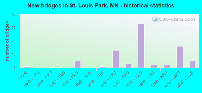
- New bridges - historical statistics
- 1Before 1900
- 51930-1939
- 11950-1959
- 131960-1969
- 31970-1979
- 331980-1989
- 21990-1999
- 22000-2009
- 162010-2019
- 52020-2022


- Bridge Condition - Deck
- 2.9%Excellent
- 5.9%Very good
- 55.9%Good
- 26.5%Satisfactory
- 8.8%Fair

- Bridge Condition - Superstructure
- 2.9%Excellent
- 11.8%Very good
- 29.4%Good
- 41.2%Satisfactory
- 14.7%Fair

- Bridge Condition - Substructure
- 5.9%Excellent
- 2.9%Very good
- 47.1%Good
- 23.5%Satisfactory
- 17.6%Fair
- 2.9%Poor

- Bridge Condition - Channel
- 14.3%Excellent
- 14.3%Very good
- 57.1%Satisfactory
- 14.3%Fair
Find on map >> Show street view
Structure Number: 27012, Location: 1.3 MI N OF JCT TH 7 (Lat: 44.955708, Lng: -93.347450), Route carried "on" structure: , Year Built: 1978, Status: Open, Structure Length: 3.87m (12.70ft), Features Intersected: TH 100, Facility Carried by Structure: PEDESTRIAN
Lanes under structure: 4, Owner: State Highway Agency, Skew: 1 degrees, Material/Design: Steel, Design/Construction: Box Beam or Girders - Multiple, Number Of Spans In Main Unit: 1, Length of Maximum Span: 38.7m (127.0ft), Out-to-Out Width: 2.9m (9.5ft)
Condition: Deck: Satisfactory, Superstructure: Satisfactory, Substructure: Satisfactory, Underclear: Equal to present desirable criteria, Bridge Posting: Required (Relationship of Operating Rating to Maximum Legal Load: > 39.9% below), Designated Inspection Frequency: Every 24 months, Inspection Date: October 2020, Deck Structure Type: Concrete Cast-file-Place, Wearing Surface/Protective System: Deck Protection: Other
Find on map >> Show street view
Structure Number: 27105, Location: 1.2 MI S OF JCT TH 7 (Lat: 44.926692, Lng: -93.349511), Route carried "on" structure: , Year Built: 1968, Status: Open, Structure Length: 5.08m (16.67ft), Features Intersected: TH 100; VERNON AVE, Facility Carried by Structure: PEDESTRIAN
Lanes under structure: 18, Owner: State Highway Agency, Material/Design: Steel continuous, Design/Construction: Stringer/Multi-beam, Number Of Spans In Main Unit: 2, Length of Maximum Span: 33.8m (110.9ft), Out-to-Out Width: 2.9m (9.5ft)
Condition: Deck: Satisfactory, Superstructure: Satisfactory, Substructure: Good, Underclear: Somewhat better than minimum adequacy, Bridge Posting: Required (Relationship of Operating Rating to Maximum Legal Load: > 39.9% below), Designated Inspection Frequency: Every 24 months, Inspection Date: May 2021, Deck Structure Type: Concrete Cast-file-Place
Find on map >> Show street view
Structure Number: 27106, Location: 0.9 MI S OF JCT TH 7 (Lat: 44.930264, Lng: -93.349961), Route carried "on" structure: County highway 3, Year Built: 1968, Status: Open, Structure Length: 6.63m (21.75ft), Average Daily Traffic: 23,300 (year 2016), Average Future Daily Traffic: 23,300 (year 2039), Design Load: HS 20, Features Intersected: TH 100; SB OFF RAMP
Minimum Vertical Clearance: 30+ m (98+ ft), Kilometerpoint: 0.000, Lanes on structure: 5, Lanes under structure: 7, Owner: State Highway Agency, Approaching Roadway Width: 21.3m (69.9ft), Skew: 22 degrees, Material/Design: Steel continuous, Design/Construction: Stringer/Multi-beam, Number Of Spans In Main Unit: 3, Length of Maximum Span: 38.4m (126.0ft), Curb or Sidewalk Widths: Left: 3.4m (11.2ft), Right: 1.8m (5.9ft), Curb-To-Curb Width: 23.8m (78.1ft), Out-to-Out Width: 31.8m (104.3ft)
Condition: Deck: Good, Superstructure: Satisfactory, Substructure: Good, Operating Rating: 56.4 metric tons, Method Used To Determine Operating Rating: Load Factor (LF), Inventory Rating: 33.9 metric tons, Method Used To Determine Inventory Rating: Load Factor (LF), Structural Evaluation: Equal to present minimum criteria, Deck Geometry: Better than present minimum criteria, Underclear: Meets minimum limits, Approach Roadway Alignment: Equal to present desirable criteria, Designated Inspection Frequency: Every 24 months, Inspection Date: May 2021, Deck Structure Type: Concrete Cast-file-Place, Wearing Surface/Protective System: Wearing Surface: Low Slump Concrete
Find on map >> Show street view
Structure Number: 27109, Location: 0.4 MI S OF JCT TH 7 (Lat: 44.937758, Lng: -93.349219), Route carried "on" structure: City street 277, Year Built: 1984, Status: Open, Structure Length: 8.88m (29.13ft), Average Daily Traffic: 12,600 (year 2017), Average Future Daily Traffic: 12,600 (year 2039), Design Load: HS 20, Features Intersected: TH 100; RAMPS
Minimum Vertical Clearance: 30+ m (98+ ft), Kilometerpoint: 0.000, Lanes on structure: 4, Lanes under structure: 8, Owner: State Highway Agency, Approaching Roadway Width: 21.9m (71.9ft), Skew: 21 degrees, Material/Design: Steel continuous, Design/Construction: Stringer/Multi-beam, Number Of Spans In Main Unit: 2, Length of Maximum Span: 46.6m (152.9ft), Curb or Sidewalk Widths: Left: 2.4m (7.9ft), Right: 3.0m (9.8ft), Curb-To-Curb Width: 17.1m (56.1ft), Out-to-Out Width: 28.8m (94.5ft)
Condition: Deck: Satisfactory, Superstructure: Satisfactory, Substructure: Good, Operating Rating: 84.1 metric tons, Method Used To Determine Operating Rating: Load Factor (LF), Inventory Rating: 50.2 metric tons, Method Used To Determine Inventory Rating: Load Factor (LF), Structural Evaluation: Equal to present minimum criteria, Deck Geometry: Somewhat better than minimum adequacy, Underclear: Equal to present minimum criteria, Approach Roadway Alignment: Equal to present desirable criteria, Designated Inspection Frequency: Every 24 months, Inspection Date: May 2021, Deck Structure Type: Concrete Cast-file-Place, Wearing Surface/Protective System: Wearing Surface: Low Slump Concrete, Deck Protection: Epoxy Coated Reinforcing
Find on map >> Show street view
Structure Number: 27255, Location: 1.1 MI N OF JCT TH 7 (Lat: 44.950061, Lng: -93.400692), Route carried "on" structure: US 169, Year Built: 1999, Status: Open, Structure Length: 4.55m (14.93ft), Average Daily Traffic: 48,500 (year 2019), Truck Traffic: 7%, Average Future Daily Traffic: 52,000 (year 2039), Design Load: HS 25 or greater, Features Intersected: BNSF RR
Minimum Vertical Clearance: 30+ m (98+ ft), Kilometerpoint: 0.000, Lanes on structure: 3, Base Highway Network: Yes, Owner: State Highway Agency, Approaching Roadway Width: 16.2m (53.1ft), Skew: 1 degrees, Material/Design: Prestressed concrete, Design/Construction: Stringer/Multi-beam, Number Of Spans In Main Unit: 3, Length of Maximum Span: 14.8m (48.6ft), Curb-To-Curb Width: 16.2m (53.1ft), Out-to-Out Width: 16.9m (55.4ft)
Condition: Deck: Good, Superstructure: Very good, Substructure: Fair, Operating Rating: 67.3 metric tons, Method Used To Determine Operating Rating: Load Factor (LF), Inventory Rating: 40.8 metric tons, Method Used To Determine Inventory Rating: Load Factor (LF), Structural Evaluation: Somewhat better than minimum adequacy, Deck Geometry: Equal to present minimum criteria, Underclear: Better than present minimum criteria, Approach Roadway Alignment: Equal to present desirable criteria, Designated Inspection Frequency: Every 24 months, Inspection Date: June 2021, Deck Structure Type: Concrete Cast-file-Place, Wearing Surface/Protective System: Wearing Surface: Monolithic Concrete, Deck Protection: Epoxy Coated Reinforcing
Find on map >> Show street view
Structure Number: 27301, Location: 1.0 M W OF JCT TH100; T7 (Lat: 44.937917, Lng: -93.369475), Route carried "on" structure: State highway 7, Year Built: 2013, Status: Open, Structure Length: 7.04m (23.10ft), Average Daily Traffic: 36,000 (year 2019), Truck Traffic: 3%, Average Future Daily Traffic: 40,000 (year 2039), Design Load: HL 93, Features Intersected: LOUISIANA AVE
Minimum Vertical Clearance: 30+ m (98+ ft), Kilometerpoint: 0.000, Lanes on structure: 4, Lanes under structure: 4, Base Highway Network: Yes, Owner: State Highway Agency, Approaching Roadway Width: 23.7m (77.8ft), Skew: 30 degrees, Material/Design: Prestressed concrete, Design/Construction: Stringer/Multi-beam, Number Of Spans In Main Unit: 2, Length of Maximum Span: 34.5m (113.2ft), Curb-To-Curb Width: 23.7m (77.8ft), Out-to-Out Width: 25.4m (83.3ft)
Condition: Deck: Good, Superstructure: Good, Substructure: Good, Operating Rating: 55.7 metric tons, Method Used To Determine Operating Rating: Load and Resistance Factor Rating (LRFR) rating reported by rating factor(RF) method using HL-93 loadings, Inventory Rating: 42.4 metric tons, Method Used To Determine Inventory Rating: Load and Resistance Factor Rating (LRFR) rating reported by rating factor(RF) method using HL-93 loadings, Structural Evaluation: Better than present minimum criteria, Deck Geometry: Superior to present desirable criteria, Approach Roadway Alignment: Equal to present desirable criteria, Designated Inspection Frequency: Every 24 months, Inspection Date: May 2021, Deck Structure Type: Concrete Cast-file-Place, Wearing Surface/Protective System: Wearing Surface: Low Slump Concrete, Deck Protection: Epoxy Coated Reinforcing
Find on map >> Show street view
Structure Number: 27303, Location: 0.2 MI S OF JCT TH 7 (Lat: 44.940892, Lng: -93.348144), Route carried "on" structure: , Year Built: 2015, Status: Closed, Structure Length: 6.75m (22.15ft), Features Intersected: TH 100, Facility Carried by Structure: RAILROAD
Lanes under structure: 10, Owner: State Highway Agency, Skew: 5 degrees, Material/Design: Steel, Design/Construction: Stringer/Multi-beam, Number Of Spans In Main Unit: 2, Length of Maximum Span: 32.4m (106.3ft), Out-to-Out Width: 6.7m (22.0ft)
Condition: Deck: Good, Superstructure: Good, Substructure: Good, Underclear: Superior to present desirable criteria, Bridge Posting: Required (Relationship of Operating Rating to Maximum Legal Load: > 39.9% below), Designated Inspection Frequency: Every 12 months, Inspection Date: October 2019, Deck Structure Type: Steel plate, Wearing Surface/Protective System: Membrane: Other
Find on map >> Show street view
Structure Number: 27304, Location: 0.2 MI S OF JCT TH 7 (Lat: 44.941108, Lng: -93.348122), Route carried "on" structure: , Year Built: 2015, Status: Open, Structure Length: 6.85m (22.47ft), Features Intersected: TH 100, Facility Carried by Structure: PEDESTRIAN
Lanes under structure: 8, Owner: State Highway Agency, Skew: 6 degrees, Material/Design: Prestressed concrete, Design/Construction: Stringer/Multi-beam, Number Of Spans In Main Unit: 2, Length of Maximum Span: 34.3m (112.5ft), Out-to-Out Width: 5.0m (16.4ft)
Condition: Deck: Very good, Superstructure: Good, Substructure: Good, Underclear: Superior to present desirable criteria, Bridge Posting: Required (Relationship of Operating Rating to Maximum Legal Load: > 39.9% below), Designated Inspection Frequency: Every 24 months, Inspection Date: October 2020, Deck Structure Type: Concrete Cast-file-Place, Wearing Surface/Protective System: Wearing Surface: Monolithic Concrete, Deck Protection: Epoxy Coated Reinforcing
Find on map >> Show street view
Structure Number: 27305, Location: AT JCT TH 100; TH 7 (Lat: 44.943731, Lng: -93.347953), Route carried "on" structure: State highway 7, Year Built: 2014, Status: Open, Structure Length: 6.91m (22.67ft), Average Daily Traffic: 32,237 (year 2019), Truck Traffic: 3%, Average Future Daily Traffic: 27,000 (year 2039), Design Load: HL 93, Features Intersected: TH 100
Minimum Vertical Clearance: 30+ m (98+ ft), Kilometerpoint: 0.000, Lanes on structure: 4, Lanes under structure: 8, Base Highway Network: Yes, Owner: State Highway Agency, Approaching Roadway Width: 24.4m (80.1ft), Skew: 23 degrees, Material/Design: Prestressed concrete, Design/Construction: Stringer/Multi-beam, Number Of Spans In Main Unit: 2, Length of Maximum Span: 33.9m (111.2ft), Curb-To-Curb Width: 31.7m (104.0ft), Out-to-Out Width: 32.8m (107.6ft)
Condition: Deck: Good, Superstructure: Very good, Substructure: Good, Operating Rating: 48.9 metric tons, Method Used To Determine Operating Rating: Load and Resistance Factor Rating (LRFR) rating reported by rating factor(RF) method using HL-93 loadings, Inventory Rating: 36.3 metric tons, Method Used To Determine Inventory Rating: Load and Resistance Factor Rating (LRFR) rating reported by rating factor(RF) method using HL-93 loadings, Structural Evaluation: Better than present minimum criteria, Deck Geometry: Superior to present desirable criteria, Underclear: Meets minimum limits, Approach Roadway Alignment: Equal to present desirable criteria, Designated Inspection Frequency: Every 24 months, Inspection Date: October 2020, Deck Structure Type: Concrete Cast-file-Place, Wearing Surface/Protective System: Wearing Surface: Low Slump Concrete, Deck Protection: Epoxy Coated Reinforcing
Find on map >> Show street view
Structure Number: 27306, Location: 0.3 MI N OF JCT TH 7 (Lat: 44.948508, Lng: -93.347900), Route carried "on" structure: County highway 5, Year Built: 2015, Status: Open, Structure Length: 6.29m (20.64ft), Average Daily Traffic: 23,400 (year 2016), Average Future Daily Traffic: 23,400 (year 2039), Design Load: HL 93, Features Intersected: TH 100
Minimum Vertical Clearance: 30+ m (98+ ft), Kilometerpoint: 0.000, Lanes on structure: 5, Lanes under structure: 8, Owner: State Highway Agency, Approaching Roadway Width: 29.0m (95.1ft), Skew: 20 degrees, Material/Design: Prestressed concrete, Design/Construction: Stringer/Multi-beam, Number Of Spans In Main Unit: 2, Length of Maximum Span: 31.6m (103.7ft), Curb or Sidewalk Widths: Left: 3.0m (9.8ft), Right: 3.0m (9.8ft), Curb-To-Curb Width: 29.0m (95.1ft), Out-to-Out Width: 35.8m (117.5ft)
Condition: Deck: Good, Superstructure: Good, Substructure: Good, Operating Rating: 85.9 metric tons, Method Used To Determine Operating Rating: Load and Resistance Factor Rating (LRFR) rating reported by rating factor(RF) method using HL-93 loadings, Inventory Rating: 38.9 metric tons, Method Used To Determine Inventory Rating: Load and Resistance Factor Rating (LRFR) rating reported by rating factor(RF) method using HL-93 loadings, Structural Evaluation: Better than present minimum criteria, Deck Geometry: Superior to present desirable criteria, Underclear: Meets minimum limits, Approach Roadway Alignment: Equal to present desirable criteria, Designated Inspection Frequency: Every 24 months, Inspection Date: October 2020, Deck Structure Type: Concrete Cast-file-Place, Wearing Surface/Protective System: Wearing Surface: Low Slump Concrete, Deck Protection: Epoxy Coated Reinforcing
Find on map >> Show street view
Structure Number: 27513, Location: 1.1 MI N OF JCT TH 7 (Lat: 44.950139, Lng: -93.400436), Route carried "on" structure: US 169, Year Built: 1963, Status: Open, Structure Length: 3.76m (12.34ft), Average Daily Traffic: 48,500 (year 2019), Truck Traffic: 7%, Average Future Daily Traffic: 52,000 (year 2039), Design Load: HS 20, Features Intersected: BNSF RR
Minimum Vertical Clearance: 30+ m (98+ ft), Kilometerpoint: 0.000, Lanes on structure: 2, Base Highway Network: Yes, Owner: State Highway Agency, Approaching Roadway Width: 14.0m (45.9ft), Skew: 1 degrees, Material/Design: Steel, Design/Construction: Stringer/Multi-beam, Number Of Spans In Main Unit: 3, Length of Maximum Span: 12.7m (41.7ft), Curb-To-Curb Width: 16.3m (53.5ft), Out-to-Out Width: 17.2m (56.4ft)
Condition: Deck: Good, Superstructure: Fair, Substructure: Satisfactory, Operating Rating: 86.9 metric tons, Method Used To Determine Operating Rating: Load Factor (LF), Inventory Rating: 52.1 metric tons, Method Used To Determine Inventory Rating: Load Factor (LF), Structural Evaluation: Somewhat better than minimum adequacy, Deck Geometry: Superior to present desirable criteria, Underclear: Meets minimum limits, Approach Roadway Alignment: Equal to present desirable criteria, Designated Inspection Frequency: Every 24 months, Inspection Date: June 2021, Deck Structure Type: Concrete Cast-file-Place, Wearing Surface/Protective System: Wearing Surface: Low Slump Concrete, Deck Protection: Epoxy Coated Reinforcing
Find on map >> Show street view
Structure Number: 27517, Location: 1.9 MI N OF JCT TH 7 (Lat: 44.954492, Lng: -93.400786), Route carried "on" structure: City street 296, Year Built: 1964, Status: Open, Structure Length: 4.73m (15.52ft), Average Daily Traffic: 9,600 (year 2017), Average Future Daily Traffic: 9,600 (year 2039), Design Load: HS 20, Features Intersected: US 169
Minimum Vertical Clearance: 30+ m (98+ ft), Kilometerpoint: 0.000, Lanes on structure: 4, Lanes under structure: 4, Owner: State Highway Agency, Approaching Roadway Width: 15.2m (49.9ft), Skew: 1 degrees, Material/Design: Steel continuous, Design/Construction: Stringer/Multi-beam, Number Of Spans In Main Unit: 3, Length of Maximum Span: 26.7m (87.6ft), Curb or Sidewalk Widths: Left: 1.1m (3.6ft), Right: 1.1m (3.6ft), Curb-To-Curb Width: 15.2m (49.9ft), Out-to-Out Width: 18.1m (59.4ft)
Condition: Deck: Fair, Superstructure: Fair, Substructure: Fair, Operating Rating: 57.1 metric tons, Method Used To Determine Operating Rating: Load Factor (LF), Inventory Rating: 34.3 metric tons, Method Used To Determine Inventory Rating: Load Factor (LF), Structural Evaluation: Somewhat better than minimum adequacy, Deck Geometry: High priority of corrective action, Underclear: High priority of corrective action, Approach Roadway Alignment: Equal to present desirable criteria, Length Of Structure Improvement: 1.59m (5.22ft), Designated Inspection Frequency: Every 24 months, Inspection Date: June 2021, Bridge Improvement Cost: $999,999,000, Roadway Improvement Cost: $89,000,000, Total Project Cost: $999,999,000, Deck Structure Type: Concrete Cast-file-Place, Wearing Surface/Protective System: Wearing Surface: Low Slump Concrete
Find on map >> Show street view
Structure Number: 27519, Location: 0.5 MI W OF JCT TEXAS AV (Lat: 44.938733, Lng: -93.390914), Route carried "on" structure: City street 282, Year Built: 1963, Status: Open, Structure Length: 1.74m (5.71ft), Average Daily Traffic: 6,900 (year 2013), Average Future Daily Traffic: 6,900 (year 2039), Design Load: HS 20, Features Intersected: MINNEHAHA CREEK
Minimum Vertical Clearance: 30+ m (98+ ft), Kilometerpoint: 0.000, Lanes on structure: 4, Owner: City or Municipal Highway Agency, Approaching Roadway Width: 17.4m (57.1ft), Skew: 20 degrees, Material/Design: Prestressed concrete, Design/Construction: Channel Beam, Number Of Spans In Main Unit: 3, Length of Maximum Span: 5.8m (19.0ft), Curb or Sidewalk Widths: Left: 1.5m (4.9ft), Right: 1.6m (5.2ft), Curb-To-Curb Width: 16.1m (52.8ft), Out-to-Out Width: 20.4m (66.9ft)
Condition: Deck: Fair, Superstructure: Fair, Substructure: Satisfactory, Channel: Satisfactory, Operating Rating: 48.2 metric tons, Method Used To Determine Operating Rating: Load Factor (LF), Inventory Rating: 28.8 metric tons, Method Used To Determine Inventory Rating: Load Factor (LF), Structural Evaluation: Somewhat better than minimum adequacy, Deck Geometry: Meets minimum limits, Waterway Adequacy: Equal to present desirable criteria, Approach Roadway Alignment: Equal to present desirable criteria, Length Of Structure Improvement: 0.73m (2.40ft), Designated Inspection Frequency: Every 24 months, Inspection Date: October 2021, Bridge Improvement Cost: $443,000,000, Roadway Improvement Cost: $5,000,000, Total Project Cost: $55,000,000, Deck Structure Type: Concrete Precast Panels, Wearing Surface/Protective System: Wearing Surface: Monolithic Concrete
Find on map >> Show street view
Structure Number: 27531, Location: 0.8 MI N OF JCT TH 7 (Lat: 44.946064, Lng: -93.400544), Route carried "on" structure: US 169, Year Built: 1967, Status: Open, Structure Length: 4.97m (16.31ft), Average Daily Traffic: 95,000 (year 2019), Truck Traffic: 7%, Average Future Daily Traffic: 102,000 (year 2039), Design Load: HS 20, Features Intersected: Minnetonka Blvd
Minimum Vertical Clearance: 30+ m (98+ ft), Kilometerpoint: 0.000, Lanes on structure: 4, Lanes under structure: 4, Base Highway Network: Yes, Owner: State Highway Agency, Approaching Roadway Width: 23.5m (77.1ft), Skew: 33 degrees, Material/Design: Prestressed concrete, Design/Construction: Stringer/Multi-beam, Number Of Spans In Main Unit: 2, Length of Maximum Span: 25.0m (82.0ft), Curb-To-Curb Width: 18.1m (59.4ft), Out-to-Out Width: 19.9m (65.3ft)
Condition: Deck: Satisfactory, Superstructure: Satisfactory, Substructure: Fair, Operating Rating: 58.1 metric tons, Method Used To Determine Operating Rating: Load Factor (LF), Inventory Rating: 30.7 metric tons, Method Used To Determine Inventory Rating: Load Factor (LF), Structural Evaluation: Somewhat better than minimum adequacy, Deck Geometry: Meets minimum limits, Underclear: High priority of corrective action, Approach Roadway Alignment: Better than present minimum criteria, Length Of Structure Improvement: 1.68m (5.51ft), Designated Inspection Frequency: Every 24 months, Inspection Date: June 2021, Bridge Improvement Cost: $999,999,000, Roadway Improvement Cost: $79,000,000, Total Project Cost: $999,999,000, Deck Structure Type: Concrete Cast-file-Place, Wearing Surface/Protective System: Wearing Surface: Low Slump Concrete
Find on map >> Show street view
Structure Number: 27579, Location: 0.3 MI N OF JCT CSAH 3 (Lat: 44.929906, Lng: -93.375747), Route carried "on" structure: City street 277, Year Built: 1977, Status: Open, Structure Length: 2.29m (7.51ft), Average Daily Traffic: 3,450 (year 2017), Average Future Daily Traffic: 3,450 (year 2039), Design Load: HS 20, Features Intersected: MINNEHAHA CREEK
Minimum Vertical Clearance: 30+ m (98+ ft), Kilometerpoint: 0.000, Lanes on structure: 2, Owner: City or Municipal Highway Agency, Approaching Roadway Width: 14.6m (47.9ft), Material/Design: Prestressed concrete, Design/Construction: Channel Beam, Number Of Spans In Main Unit: 3, Length of Maximum Span: 7.6m (24.9ft), Curb or Sidewalk Widths: Left: 0.0m, Right: 1.8m (5.9ft), Curb-To-Curb Width: 14.6m (47.9ft), Out-to-Out Width: 18.0m (59.1ft)
Condition: Deck: Good, Superstructure: Good, Substructure: Good, Channel: Satisfactory, Operating Rating: 44.5 metric tons, Method Used To Determine Operating Rating: Load Factor (LF), Inventory Rating: 26.6 metric tons, Method Used To Determine Inventory Rating: Load Factor (LF), Structural Evaluation: Equal to present minimum criteria, Deck Geometry: Superior to present desirable criteria, Waterway Adequacy: Equal to present desirable criteria, Approach Roadway Alignment: Equal to present desirable criteria, Length Of Structure Improvement: 0.82m (2.69ft), Designated Inspection Frequency: Every 24 months, Inspection Date: October 2021, Bridge Improvement Cost: $438,000,000, Roadway Improvement Cost: $8,000,000, Total Project Cost: $95,000,000, Deck Structure Type: Concrete Cast-file-Place, Wearing Surface/Protective System: Wearing Surface: Low Slump Concrete
Find on map >> Show street view
Structure Number: 27583, Location: 0.3 MI N OF JCT TH 7 (Lat: 44.939756, Lng: -93.397081), Route carried "on" structure: City street 282, Year Built: 1983, Status: Open, Structure Length: 6.65m (21.82ft), Average Daily Traffic: 6,900 (year 2013), Average Future Daily Traffic: 6,900 (year 2039), Design Load: HS 20, Features Intersected: US 169
Minimum Vertical Clearance: 30+ m (98+ ft), Kilometerpoint: 0.000, Lanes on structure: 2, Lanes under structure: 4, Owner: State Highway Agency, Approaching Roadway Width: 13.4m (44.0ft), Skew: 2 degrees, Material/Design: Prestressed concrete, Design/Construction: Stringer/Multi-beam, Number Of Spans In Main Unit: 2, Length of Maximum Span: 33.2m (108.9ft), Curb or Sidewalk Widths: Left: 0.0m, Right: 2.4m (7.9ft), Curb-To-Curb Width: 13.4m (44.0ft), Out-to-Out Width: 17.1m (56.1ft)
Condition: Deck: Good, Superstructure: Satisfactory, Substructure: Fair, Operating Rating: 62.9 metric tons, Method Used To Determine Operating Rating: Load Factor (LF), Inventory Rating: 42.3 metric tons, Method Used To Determine Inventory Rating: Load Factor (LF), Structural Evaluation: Somewhat better than minimum adequacy, Deck Geometry: Equal to present minimum criteria, Underclear: Somewhat better than minimum adequacy, Approach Roadway Alignment: Equal to present desirable criteria, Designated Inspection Frequency: Every 24 months, Inspection Date: June 2021, Deck Structure Type: Concrete Cast-file-Place, Wearing Surface/Protective System: Wearing Surface: Low Slump Concrete, Deck Protection: Epoxy Coated Reinforcing
Find on map >> Show street view
Structure Number: 27621, Location: 0.2 MI S OF JCT CSAH 16 (Lat: 44.956853, Lng: -93.370903), Route carried "on" structure: City street 276, Year Built: 1982, Status: Open, Structure Length: 5.12m (16.80ft), Average Daily Traffic: 16,700 (year 2017), Average Future Daily Traffic: 16,700 (year 2039), Design Load: HS 20, Features Intersected: BNSF RR; CEDAR LK TRL
Minimum Vertical Clearance: 30+ m (98+ ft), Kilometerpoint: 0.000, Lanes on structure: 4, Owner: City or Municipal Highway Agency, Approaching Roadway Width: 16.5m (54.1ft), Skew: 1 degrees, Material/Design: Steel continuous, Design/Construction: Stringer/Multi-beam, Number Of Spans In Main Unit: 3, Length of Maximum Span: 19.2m (63.0ft), Curb or Sidewalk Widths: Left: 1.8m (5.9ft), Right: 1.8m (5.9ft), Curb-To-Curb Width: 16.7m (54.8ft), Out-to-Out Width: 21.8m (71.5ft)
Condition: Deck: Satisfactory, Superstructure: Satisfactory, Substructure: Good, Operating Rating: 68.9 metric tons, Method Used To Determine Operating Rating: Load Factor (LF), Inventory Rating: 41.2 metric tons, Method Used To Determine Inventory Rating: Load Factor (LF), Structural Evaluation: Equal to present minimum criteria, Deck Geometry: Somewhat better than minimum adequacy, Underclear: Equal to present minimum criteria, Approach Roadway Alignment: Better than present minimum criteria, Designated Inspection Frequency: Every 24 months, Inspection Date: October 2021, Deck Structure Type: Concrete Cast-file-Place, Wearing Surface/Protective System: Wearing Surface: Low Slump Concrete, Deck Protection: Epoxy Coated Reinforcing
Find on map >> Show street view
Structure Number: 27688, Location: 0.5 MI S OF JCT CSAH 3 (Lat: 44.922058, Lng: -93.354119), Route carried "on" structure: City street 305, Year Built: 1991, Status: Open, Structure Length: 1.48m (4.86ft), Average Daily Traffic: 2,150 (year 2017), Average Future Daily Traffic: 2,150 (year 2039), Design Load: HS 25 or greater, Features Intersected: MINNEHAHA CREEK
Minimum Vertical Clearance: 30+ m (98+ ft), Kilometerpoint: 0.000, Lanes on structure: 2, Owner: City or Municipal Highway Agency, Approaching Roadway Width: 9.8m (32.2ft), Skew: 1 degrees, Material/Design: Concrete, Design/Construction: Slab, Number Of Spans In Main Unit: 1, Length of Maximum Span: 13.4m (44.0ft), Curb or Sidewalk Widths: Left: 1.8m (5.9ft), Right: 1.8m (5.9ft), Curb-To-Curb Width: 9.8m (32.2ft), Out-to-Out Width: 14.8m (48.6ft)
Condition: Deck: Good, Superstructure: Good, Substructure: Good, Channel: Satisfactory, Operating Rating: 84.5 metric tons, Method Used To Determine Operating Rating: Load Factor (LF), Inventory Rating: 50.6 metric tons, Method Used To Determine Inventory Rating: Load Factor (LF), Structural Evaluation: Better than present minimum criteria, Deck Geometry: Meets minimum limits, Waterway Adequacy: Equal to present desirable criteria, Approach Roadway Alignment: Somewhat better than minimum adequacy, Designated Inspection Frequency: Every 24 months, Inspection Date: October 2021, Deck Structure Type: Concrete Cast-file-Place, Wearing Surface/Protective System: Wearing Surface: Low Slump Concrete, Deck Protection: Epoxy Coated Reinforcing
Find on map >> Show street view
Structure Number: 27738, Location: 2.3 MI E OF JCT TH 494 (Lat: 44.973094, Lng: -93.409006), Route carried "on" structure: City street 535, Year Built: 1987, Status: Open, Structure Length: 6.54m (21.46ft), Average Daily Traffic: 3,450 (year 2017), Average Future Daily Traffic: 3,450 (year 2039), Design Load: HS 20, Features Intersected: I 394
Minimum Vertical Clearance: 30+ m (98+ ft), Kilometerpoint: 0.000, Lanes on structure: 4, Lanes under structure: 6, Owner: State Highway Agency, Approaching Roadway Width: 15.9m (52.2ft), Material/Design: Prestressed concrete, Design/Construction: Stringer/Multi-beam, Number Of Spans In Main Unit: 2, Length of Maximum Span: 32.0m (105.0ft), Curb or Sidewalk Widths: Left: 0.0m, Right: 2.4m (7.9ft), Curb-To-Curb Width: 16.3m (53.5ft), Out-to-Out Width: 19.6m (64.3ft)
Condition: Deck: Good, Superstructure: Good, Substructure: Good, Operating Rating: 77.7 metric tons, Method Used To Determine Operating Rating: Load Factor (LF), Inventory Rating: 34.7 metric tons, Method Used To Determine Inventory Rating: Load Factor (LF), Structural Evaluation: Better than present minimum criteria, Deck Geometry: Meets minimum limits, Underclear: Equal to present minimum criteria, Approach Roadway Alignment: Equal to present desirable criteria, Designated Inspection Frequency: Every 24 months, Inspection Date: June 2021, Deck Structure Type: Concrete Cast-file-Place, Wearing Surface/Protective System: Wearing Surface: Low Slump Concrete, Deck Protection: Epoxy Coated Reinforcing
Find on map >> Show street view
Structure Number: 27739, Location: AT THE JCT TH 169; 394 (Lat: 44.971758, Lng: -93.401417), Route carried "on" structure: Ramp Interstate 571, Year Built: 1987, Status: Open, Structure Length: 4.43m (14.53ft), Average Daily Traffic: 4,500 (year 1996), Average Future Daily Traffic: 4,500 (year 2029), Design Load: HS 20, Features Intersected: S FRONTAGE RD
Minimum Vertical Clearance: 30+ m (98+ ft), Kilometerpoint: 0.000, Lanes on structure: 1, Lanes under structure: 2, Base Highway Network: Yes, Owner: State Highway Agency, Approaching Roadway Width: 4.9m (16.1ft), Skew: 5 degrees, Material/Design: Steel, Design/Construction: Stringer/Multi-beam, Number Of Spans In Main Unit: 1, Length of Maximum Span: 41.5m (136.2ft), Curb-To-Curb Width: 7.7m (25.3ft), Out-to-Out Width: 8.7m (28.5ft)
Condition: Deck: Good, Superstructure: Good, Substructure: Good, Operating Rating: 99.6 metric tons, Method Used To Determine Operating Rating: Load Factor (LF), Inventory Rating: 68.6 metric tons, Method Used To Determine Inventory Rating: Load Factor (LF), Structural Evaluation: Better than present minimum criteria, Deck Geometry: Better than present minimum criteria, Underclear: Meets minimum limits, Approach Roadway Alignment: Equal to present desirable criteria, Designated Inspection Frequency: Every 24 months, Inspection Date: June 2021, Deck Structure Type: Concrete Cast-file-Place, Wearing Surface/Protective System: Wearing Surface: Low Slump Concrete, Deck Protection: Epoxy Coated Reinforcing
Find on map >> Show street view
Structure Number: 2774, Location: 0.1 MI S OF JCT TH 394 (Lat: 44.971578, Lng: -93.400575), Route carried "on" structure: US 169, Year Built: 1987, Status: Open, Structure Length: 2.58m (8.46ft), Average Daily Traffic: 98,000 (year 2019), Truck Traffic: 7%, Average Future Daily Traffic: 100,000 (year 2039), Design Load: HS 20, Features Intersected: South Frontage Rd
Minimum Vertical Clearance: 30+ m (98+ ft), Kilometerpoint: 0.000, Lanes on structure: 4, Lanes under structure: 2, Base Highway Network: Yes, Owner: State Highway Agency, Approaching Roadway Width: 23.2m (76.1ft), Skew: 31 degrees, Material/Design: Prestressed concrete, Design/Construction: Stringer/Multi-beam, Number Of Spans In Main Unit: 1, Length of Maximum Span: 24.4m (80.1ft), Curb-To-Curb Width: 22.6m (74.1ft), Out-to-Out Width: 23.8m (78.1ft)
Condition: Deck: Good, Superstructure: Good, Substructure: Good, Operating Rating: 59.0 metric tons, Method Used To Determine Operating Rating: Load Factor (LF), Inventory Rating: 34.1 metric tons, Method Used To Determine Inventory Rating: Load Factor (LF), Structural Evaluation: Better than present minimum criteria, Deck Geometry: Superior to present desirable criteria, Underclear: Meets minimum limits, Approach Roadway Alignment: Equal to present desirable criteria, Designated Inspection Frequency: Every 24 months, Inspection Date: June 2021, Deck Structure Type: Concrete Cast-file-Place, Wearing Surface/Protective System: Wearing Surface: Low Slump Concrete, Deck Protection: Epoxy Coated Reinforcing
Find on map >> Show street view
Structure Number: 27742, Location: AT THE JCT TH 169; 394 (Lat: 44.973397, Lng: -93.400581), Route carried "on" structure: US 169, Year Built: 1987, Status: Open, Structure Length: 8.68m (28.48ft), Average Daily Traffic: 98,000 (year 2019), Truck Traffic: 7%, Average Future Daily Traffic: 100,000 (year 2039), Design Load: HS 20, Features Intersected: I 394; N-S COLLECTOR RD
Minimum Vertical Clearance: 30+ m (98+ ft), Kilometerpoint: 0.000, Lanes on structure: 4, Lanes under structure: 10, Base Highway Network: Yes, Owner: State Highway Agency, Approaching Roadway Width: 22.6m (74.1ft), Skew: 31 degrees, Material/Design: Prestressed concrete, Design/Construction: Stringer/Multi-beam, Number Of Spans In Main Unit: 2, Length of Maximum Span: 42.7m (140.1ft), Curb-To-Curb Width: 31.7m (104.0ft), Out-to-Out Width: 33.3m (109.3ft)
Condition: Deck: Satisfactory, Superstructure: Satisfactory, Substructure: Fair, Operating Rating: 75.7 metric tons, Method Used To Determine Operating Rating: Load Factor (LF), Inventory Rating: 31.7 metric tons, Method Used To Determine Inventory Rating: Load Factor (LF), Structural Evaluation: Somewhat better than minimum adequacy, Deck Geometry: Superior to present desirable criteria, Underclear: Somewhat better than minimum adequacy, Approach Roadway Alignment: Equal to present desirable criteria, Designated Inspection Frequency: Every 24 months, Inspection Date: June 2021, Deck Structure Type: Concrete Cast-file-Place, Wearing Surface/Protective System: Wearing Surface: Low Slump Concrete, Deck Protection: Epoxy Coated Reinforcing
Find on map >> Show street view
Structure Number: 27746, Location: 0.8 MI W OF JCT TH 100 (Lat: 44.970497, Lng: -93.356469), Route carried "on" structure: , Year Built: 1988, Status: Open, Structure Length: 9.67m (31.73ft), Features Intersected: I 394; COLLECTOR RDS, Facility Carried by Structure: RAILROAD
Lanes under structure: 30, Owner: State Highway Agency, Skew: 2 degrees, Material/Design: Steel, Design/Construction: Girder and Floorbeam System, Number Of Spans In Main Unit: 2, Length of Maximum Span: 46.4m (152.2ft), Out-to-Out Width: 6.7m (22.0ft)
Condition: Deck: Satisfactory, Superstructure: Satisfactory, Substructure: Satisfactory, Underclear: Equal to present minimum criteria, Bridge Posting: Required (Relationship of Operating Rating to Maximum Legal Load: > 39.9% below), Length Of Structure Improvement: 3.14m (10.30ft), Designated Inspection Frequency: Every 12 months, Inspection Date: September 2021, Bridge Improvement Cost: $999,999,000, Total Project Cost: $999,999,000, Deck Structure Type: Steel plate
Find on map >> Show street view
Structure Number: 27747, Location: 0.4 MI W OF JCT TH 100 (Lat: 44.970444, Lng: -93.351242), Route carried "on" structure: City street 278, Year Built: 1988, Status: Open, Structure Length: 8.35m (27.40ft), Average Daily Traffic: 20,972 (year 2019), Truck Traffic: 4%, Average Future Daily Traffic: 20,600 (year 2039), Design Load: HS 20, Features Intersected: I 394; COLLECTOR RDS
Minimum Vertical Clearance: 30+ m (98+ ft), Kilometerpoint: 0.000, Lanes on structure: 8, Lanes under structure: 9, Owner: State Highway Agency, Approaching Roadway Width: 34.4m (112.9ft), Skew: 22 degrees, Material/Design: Prestressed concrete, Design/Construction: Stringer/Multi-beam, Number Of Spans In Main Unit: 2, Length of Maximum Span: 41.6m (136.5ft), Curb or Sidewalk Widths: Left: 2.4m (7.9ft), Right: 2.4m (7.9ft), Curb-To-Curb Width: 31.7m (104.0ft), Out-to-Out Width: 40.0m (131.2ft)
Condition: Deck: Good, Superstructure: Satisfactory, Substructure: Good, Operating Rating: 57.8 metric tons, Method Used To Determine Operating Rating: Load Factor (LF), Inventory Rating: 34.6 metric tons, Method Used To Determine Inventory Rating: Load Factor (LF), Structural Evaluation: Equal to present minimum criteria, Deck Geometry: Somewhat better than minimum adequacy, Underclear: Somewhat better than minimum adequacy, Approach Roadway Alignment: Equal to present desirable criteria, Designated Inspection Frequency: Every 24 months, Inspection Date: October 2020, Deck Structure Type: Concrete Cast-file-Place, Wearing Surface/Protective System: Wearing Surface: Low Slump Concrete, Deck Protection: Epoxy Coated Reinforcing
Find on map >> Show street view
Structure Number: 27786, Location: 0.6 MI S OF JCT TH 394 (Lat: 44.961883, Lng: -93.344964), Route carried "on" structure: Ramp State highway 6471, Year Built: 1989, Status: Open, Structure Length: 7.43m (24.38ft), Average Daily Traffic: 4,225 (year 1994), Average Future Daily Traffic: 4,225 (year 2029), Design Load: HS 25 or greater, Features Intersected: BNSF RR; CITY STREETS
Minimum Vertical Clearance: 30+ m (98+ ft), Kilometerpoint: 0.000, Lanes on structure: 2, Lanes under structure: 4, Base Highway Network: Yes, Owner: State Highway Agency, Approaching Roadway Width: 12.2m (40.0ft), Skew: 2 degrees, Material/Design: Prestressed concrete, Design/Construction: Stringer/Multi-beam, Number Of Spans In Main Unit: 4, Length of Maximum Span: 18.3m (60.0ft), Curb-To-Curb Width: 11.8m (38.7ft), Out-to-Out Width: 12.8m (42.0ft)
Condition: Deck: Good, Superstructure: Satisfactory, Substructure: Satisfactory, Operating Rating: 49.6 metric tons, Method Used To Determine Operating Rating: Load Factor (LF), Inventory Rating: 29.8 metric tons, Method Used To Determine Inventory Rating: Load Factor (LF), Structural Evaluation: Equal to present minimum criteria, Deck Geometry: Superior to present desirable criteria, Underclear: High priority of corrective action, Approach Roadway Alignment: Equal to present desirable criteria, Length Of Structure Improvement: 2.50m (8.20ft), Designated Inspection Frequency: Every 24 months, Inspection Date: October 2020, Bridge Improvement Cost: $999,999,000, Deck Structure Type: Concrete Cast-file-Place, Wearing Surface/Protective System: Wearing Surface: Low Slump Concrete, Deck Protection: Epoxy Coated Reinforcing
Find on map >> Show street view
Structure Number: 27787, Location: 0.6 MI S OF JCT TH 394 (Lat: 44.962047, Lng: -93.344169), Route carried "on" structure: ServiceCity street 552, Year Built: 1989, Status: Open, Structure Length: 7.43m (24.38ft), Average Daily Traffic: 5,000 (year 1996), Average Future Daily Traffic: 5,000 (year 2029), Design Load: HS 25 or greater, Features Intersected: BNSF RR; CITY STREETS
Minimum Vertical Clearance: 30+ m (98+ ft), Kilometerpoint: 0.000, Lanes on structure: 2, Lanes under structure: 4, Owner: State Highway Agency, Approaching Roadway Width: 10.7m (35.1ft), Skew: 2 degrees, Material/Design: Prestressed concrete, Design/Construction: Stringer/Multi-beam, Number Of Spans In Main Unit: 4, Length of Maximum Span: 18.3m (60.0ft), Curb-To-Curb Width: 10.6m (34.8ft), Out-to-Out Width: 12.8m (42.0ft)
Condition: Deck: Good, Superstructure: Satisfactory, Substructure: Satisfactory, Operating Rating: 67.8 metric tons, Method Used To Determine Operating Rating: Load Factor (LF), Inventory Rating: 40.4 metric tons, Method Used To Determine Inventory Rating: Load Factor (LF), Structural Evaluation: Equal to present minimum criteria, Deck Geometry: Somewhat better than minimum adequacy, Underclear: High priority of corrective action, Approach Roadway Alignment: Equal to present desirable criteria, Length Of Structure Improvement: 2.50m (8.20ft), Designated Inspection Frequency: Every 24 months, Inspection Date: October 2020, Bridge Improvement Cost: $999,999,000, Deck Structure Type: Concrete Cast-file-Place, Wearing Surface/Protective System: Wearing Surface: Low Slump Concrete, Deck Protection: Epoxy Coated Reinforcing
Find on map >> Show street view
Structure Number: 27788, Location: 0.4 MI S OF JCT TH 100 (Lat: 44.965539, Lng: -93.342864), Route carried "on" structure: Ramp Interstate 2918, Year Built: 1989, Status: Open, Structure Length: 8.80m (28.87ft), Average Daily Traffic: 4,500 (year 1994), Average Future Daily Traffic: 4,500 (year 2029), Design Load: HS 25 or greater, Features Intersected: TH 100 NB on ramp
Minimum Vertical Clearance: 30+ m (98+ ft), Kilometerpoint: 0.000, Lanes on structure: 1, Lanes under structure: 1, Base Highway Network: Yes, Owner: State Highway Agency, Approaching Roadway Width: 7.6m (24.9ft), Material/Design: Steel continuous, Design/Construction: Stringer/Multi-beam, Number Of Spans In Main Unit: 2, Length of Maximum Span: 43.3m (142.1ft), Curb-To-Curb Width: 6.9m (22.6ft), Out-to-Out Width: 8.0m (26.2ft)
Condition: Deck: Satisfactory, Superstructure: Fair, Substructure: Satisfactory, Operating Rating: 40.2 metric tons, Method Used To Determine Operating Rating: Load and Resistance Factor Rating (LRFR) rating reported by rating factor(RF) method using HL-93 loadings, Inventory Rating: 31.1 metric tons, Method Used To Determine Inventory Rating: Load and Resistance Factor Rating (LRFR) rating reported by rating factor(RF) method using HL-93 loadings, Structural Evaluation: Somewhat better than minimum adequacy, Deck Geometry: Equal to present minimum criteria, Underclear: Equal to present minimum criteria, Approach Roadway Alignment: Equal to present desirable criteria, Length Of Structure Improvement: 2.96m (9.71ft), Designated Inspection Frequency: Every 12 months, Critical Feature Inspection Frequency: Every 24 months, Inspection Date: April 2021, Critical Feature Inspection Date: April 2021, Bridge Improvement Cost: $827,000,000, Deck Structure Type: Concrete Cast-file-Place, Wearing Surface/Protective System: Wearing Surface: Low Slump Concrete, Deck Protection: Epoxy Coated Reinforcing
Find on map >> Show street view
Structure Number: 27B65, Location: 2.1 MI E OF JCT TH 169 (Lat: 44.939158, Lng: -93.356536), Route carried "on" structure: City street 280, Year Built: 2009, Status: Open, Structure Length: 3.51m (11.52ft), Average Daily Traffic: 11,000 (year 2017), Truck Traffic: 3%, Average Future Daily Traffic: 11,000 (year 2039), Design Load: HL 93, Features Intersected: TH 7
Minimum Vertical Clearance: 30+ m (98+ ft), Kilometerpoint: 0.000, Lanes on structure: 4, Lanes under structure: 4, Owner: State Highway Agency, Approaching Roadway Width: 18.9m (62.0ft), Skew: 11 degrees, Material/Design: Prestressed concrete, Design/Construction: Stringer/Multi-beam, Number Of Spans In Main Unit: 1, Length of Maximum Span: 33.5m (109.9ft), Curb or Sidewalk Widths: Left: 2.4m (7.9ft), Right: 3.7m (12.1ft), Curb-To-Curb Width: 24.4m (80.1ft), Out-to-Out Width: 25.7m (84.3ft)
Condition: Deck: Good, Superstructure: Good, Substructure: Good, Operating Rating: 45.0 metric tons, Method Used To Determine Operating Rating: Load and Resistance Factor Rating (LRFR) rating reported by rating factor(RF) method using HL-93 loadings, Inventory Rating: 34.7 metric tons, Method Used To Determine Inventory Rating: Load and Resistance Factor Rating (LRFR) rating reported by rating factor(RF) method using HL-93 loadings, Structural Evaluation: Better than present minimum criteria, Deck Geometry: Superior to present desirable criteria, Underclear: Better than present minimum criteria, Approach Roadway Alignment: Equal to present desirable criteria, Designated Inspection Frequency: Every 24 months, Inspection Date: May 2021, Deck Structure Type: Concrete Cast-file-Place, Wearing Surface/Protective System: Wearing Surface: Low Slump Concrete, Deck Protection: Epoxy Coated Reinforcing
Find on map >> Show street view
Structure Number: 27C19, Location: 0.2 MI N OF JCT CSAH 3 (Lat: 44.929472, Lng: -93.365172), Route carried "on" structure: City street 276, Year Built: 2021, Status: Open, Structure Length: 3.72m (12.20ft), Average Daily Traffic: 13,300 (year 2018), Average Future Daily Traffic: 19,100 (year 2039), Design Load: HL 93, Features Intersected: MINNEHAHA CREEK, Facility Carried by Structure: LOUISIANA AVE S
Minimum Vertical Clearance: 30+ m (98+ ft), Kilometerpoint: 0.000, Lanes on structure: 4, Owner: City or Municipal Highway Agency, Approaching Roadway Width: 15.9m (52.2ft), Skew: 34 degrees, Material/Design: Prestressed concrete, Design/Construction: Stringer/Multi-beam, Number Of Spans In Main Unit: 1, Length of Maximum Span: 35.1m (115.2ft), Curb or Sidewalk Widths: Left: 3.9m (12.8ft), Right: 3.9m (12.8ft), Curb-To-Curb Width: 15.9m (52.2ft), Out-to-Out Width: 26.7m (87.6ft)
Condition: Deck: Excellent, Superstructure: Excellent, Substructure: Excellent, Channel: Excellent, Operating Rating: 48.3 metric tons, Method Used To Determine Operating Rating: Load and Resistance Factor Rating (LRFR) rating reported by rating factor(RF) method using HL-93 loadings, Inventory Rating: 37.3 metric tons, Method Used To Determine Inventory Rating: Load and Resistance Factor Rating (LRFR) rating reported by rating factor(RF) method using HL-93 loadings, Structural Evaluation: Superior to present desirable criteria, Deck Geometry: Meets minimum limits, Waterway Adequacy: Superior to present desirable criteria, Approach Roadway Alignment: Equal to present desirable criteria, Designated Inspection Frequency: Every 24 months, Inspection Date: November 2021, Deck Structure Type: Concrete Cast-file-Place, Wearing Surface/Protective System: Wearing Surface: Monolithic Concrete, Deck Protection: Epoxy Coated Reinforcing
Find on map >> Show street view
Structure Number: 27C49, Location: 0.3 MI W OF AQUILLA AVE (Lat: 44.936131, Lng: -93.389708), Route carried "on" structure: City street 275, Year Built: 2017, Status: Open, Structure Length: 2.55m (8.37ft), Average Daily Traffic: 8,300 (year 2016), Average Future Daily Traffic: 9,200 (year 2037), Design Load: HL 93, Features Intersected: MINNEHAHA CREEK
Minimum Vertical Clearance: 30+ m (98+ ft), Kilometerpoint: 0.000, Lanes on structure: 4, Owner: City or Municipal Highway Agency, Approaching Roadway Width: 15.9m (52.2ft), Skew: 3 degrees, Material/Design: Prestressed concrete, Design/Construction: Stringer/Multi-beam, Number Of Spans In Main Unit: 1, Length of Maximum Span: 24.4m (80.1ft), Curb or Sidewalk Widths: Left: 2.1m (6.9ft), Right: 2.0m (6.6ft), Curb-To-Curb Width: 15.9m (52.2ft), Out-to-Out Width: 21.0m (68.9ft)
Condition: Deck: Good, Superstructure: Very good, Substructure: Excellent, Channel: Very good, Operating Rating: 61.9 metric tons, Method Used To Determine Operating Rating: Load and Resistance Factor Rating (LRFR) rating reported by rating factor(RF) method using HL-93 loadings, Inventory Rating: 47.6 metric tons, Method Used To Determine Inventory Rating: Load and Resistance Factor Rating (LRFR) rating reported by rating factor(RF) method using HL-93 loadings, Structural Evaluation: Equal to present desirable criteria, Deck Geometry: Meets minimum limits, Waterway Adequacy: Equal to present desirable criteria, Approach Roadway Alignment: Equal to present desirable criteria, Designated Inspection Frequency: Every 24 months, Inspection Date: November 2020, Deck Structure Type: Concrete Cast-file-Place, Wearing Surface/Protective System: Wearing Surface: Low Slump Concrete, Deck Protection: Epoxy Coated Reinforcing
Find on map >> Show street view
Structure Number: 27W34, Location: 0.2 MI S OF JCT TH 7 (Lat: 44.940997, Lng: -93.348136), Route carried "on" structure: , Year Built: 2020, Status: Open, Structure Length: 6.75m (22.15ft), Features Intersected: MN 100; RAMPS, Facility Carried by Structure: RAILROAD
Lanes under structure: 8, Owner: State Highway Agency, Skew: 5 degrees, Material/Design: Steel, Design/Construction: Stringer/Multi-beam, Number Of Spans In Main Unit: 2, Length of Maximum Span: 32.4m (106.3ft), Out-to-Out Width: 6.7m (22.0ft)
Condition: Deck: Very good, Superstructure: Very good, Substructure: Very good, Underclear: High priority of corrective action, Bridge Posting: Required (Relationship of Operating Rating to Maximum Legal Load: > 39.9% below), Designated Inspection Frequency: Every 12 months, Inspection Date: September 2021, Deck Structure Type: Steel plate
Find on map >> Show street view
Structure Number: 5199, Location: 0.9 MI SW OF JCT TH 100 (Lat: 44.938142, Lng: -93.362672), Route carried "on" structure: , Year Built: 1934, Status: Open, Structure Length: 2.73m (8.96ft), Features Intersected: TH 7, Facility Carried by Structure: RAILROAD
Lanes under structure: 4, Owner: State Highway Agency, Skew: 6 degrees, Material/Design: Steel, Design/Construction: Girder and Floorbeam System, Number Of Spans In Main Unit: 1, Length of Maximum Span: 26.4m (86.6ft), Out-to-Out Width: 5.5m (18.0ft)
Condition: Deck: Fair, Superstructure: Fair, Substructure: Fair, Underclear: Meets minimum limits, Bridge Posting: Required (Relationship of Operating Rating to Maximum Legal Load: > 39.9% below), Length Of Structure Improvement: 1.01m (3.31ft), Designated Inspection Frequency: Every 12 months, Inspection Date: September 2021, Bridge Improvement Cost: $657,000,000, Roadway Improvement Cost: $77,000,000, Total Project Cost: $999,999,000, Deck Structure Type: Concrete Cast-file-Place
Find on map >> Show street view
Structure Number: 531, Location: 1.3 MI N OF JCT TH 7 (Lat: 44.962131, Lng: -93.344483), Route carried "on" structure: State highway 100, Year Built: 1936, Year Reconstructed: 1989, Status: Open, Structure Length: 7.41m (24.31ft), Average Daily Traffic: 142,000 (year 2019), Truck Traffic: 2%, Average Future Daily Traffic: 133,000 (year 2039), Design Load: HS 20, Features Intersected: BNSF, CEDAR LK; 23RD
Minimum Vertical Clearance: 30+ m (98+ ft), Kilometerpoint: 0.000, Lanes on structure: 6, Lanes under structure: 8, Base Highway Network: Yes, Owner: State Highway Agency, Approaching Roadway Width: 31.1m (102.0ft), Skew: 32 degrees, Material/Design: Steel, Design/Construction: Stringer/Multi-beam, Number Of Spans In Main Unit: 4, Length of Maximum Span: 18.3m (60.0ft), Curb-To-Curb Width: 36.0m (118.1ft), Out-to-Out Width: 37.6m (123.4ft)
Condition: Deck: Good, Superstructure: Satisfactory, Substructure: Satisfactory, Operating Rating: 99.0 metric tons, Method Used To Determine Operating Rating: Load Factor (LF), Inventory Rating: 59.2 metric tons, Method Used To Determine Inventory Rating: Load Factor (LF), Structural Evaluation: Equal to present minimum criteria, Deck Geometry: Superior to present desirable criteria, Underclear: High priority of corrective action, Approach Roadway Alignment: Better than present minimum criteria, Length Of Structure Improvement: 2.47m (8.10ft), Designated Inspection Frequency: Every 24 months, Inspection Date: October 2020, Bridge Improvement Cost: $999,999,000, Roadway Improvement Cost: $110,000,000, Total Project Cost: $999,999,000, Deck Structure Type: Concrete Cast-file-Place, Wearing Surface/Protective System: Wearing Surface: Low Slump Concrete, Deck Protection: Epoxy Coated Reinforcing
Find on map >> Show street view
Structure Number: 91115, Location: 0.7 MI N OF JCT TH 7 (Lat: 44.943836, Lng: -93.400131), Route carried "on" structure: US 169, Year Built: 1967, Status: Open, Structure Length: 1.02m (3.35ft), Average Daily Traffic: 95,000 (year 2019), Truck Traffic: 7%, Average Future Daily Traffic: 102,000 (year 2039), Features Intersected: MINNEHAHA CREEK
Minimum Vertical Clearance: 30+ m (98+ ft), Kilometerpoint: 0.000, Lanes on structure: 4, Base Highway Network: Yes, Owner: State Highway Agency, Approaching Roadway Width: 37.8m (124.0ft), Skew: 20 degrees, Material/Design: Concrete, Design/Construction: Culvert, Number Of Spans In Main Unit: 3, Length of Maximum Span: 3.0m (9.8ft)
Condition: Channel: Satisfactory, Culverts: Satisfactory, Operating Rating: 53.9 metric tons, Method Used To Determine Operating Rating: Assigned ratings based on Allowable Stress Design (ASD) reported in metric tons, Inventory Rating: 35.9 metric tons, Method Used To Determine Inventory Rating: Assigned ratings based on Allowable Stress Design (ASD) reported in metric tons, Structural Evaluation: Equal to present minimum criteria, Waterway Adequacy: Equal to present minimum criteria, Approach Roadway Alignment: Better than present minimum criteria, Designated Inspection Frequency: Every 48 months, Underwater Inspection Frequency: Every 60 months, Inspection Date: June 2021, Underwater Inspection Date: August 2020
Find on map >> Show street view
Structure Number: 92687, Location: 0.5 MI SW OF JCT CSAH 5 (Lat: 44.942769, Lng: -93.393281), Route carried "on" structure: City street 60, Year Built: 1950, Status: Posted for load, Structure Length: 0.82m (2.69ft), Average Daily Traffic: 693 (year 1986), Average Future Daily Traffic: 693 (year 2029), Features Intersected: MINNEHAHA CREEK
Minimum Vertical Clearance: 30+ m (98+ ft), Kilometerpoint: 0.000, Lanes on structure: 2, Owner: City or Municipal Highway Agency, Approaching Roadway Width: 9.1m (29.9ft), Material/Design: Wood or Timber, Design/Construction: Slab, Number Of Spans In Main Unit: 1, Length of Maximum Span: 7.5m (24.6ft), Curb or Sidewalk Widths: Left: 1.3m (4.3ft), Right: 1.3m (4.3ft), Curb-To-Curb Width: 9.3m (30.5ft), Out-to-Out Width: 12.3m (40.4ft)
Condition: Deck: Satisfactory, Superstructure: Satisfactory, Substructure: Poor, Channel: Fair, Operating Rating: 35.9 metric tons, Method Used To Determine Operating Rating: Field evaluation and documented engineering judgment, Inventory Rating: 22.9 metric tons, Method Used To Determine Inventory Rating: Field evaluation and documented engineering judgment, Structural Evaluation: Meets minimum limits, Deck Geometry: Equal to present minimum criteria, Waterway Adequacy: Better than present minimum criteria, Approach Roadway Alignment: Equal to present minimum criteria, Bridge Posting: Required (Relationship of Operating Rating to Maximum Legal Load: 30.0 - 39.9% below), Designated Inspection Frequency: Every 12 months, Inspection Date: October 2021, Deck Structure Type: Wood or Timber, Wearing Surface/Protective System: Wearing Surface: Bituminous
Find on map >> Show street view
Structure Number: R0823, Location: PARK 0 (Lat: 0.511222, Lng: -20.350000), Route carried "on" structure: , Year Built: 7 , Structure Length: 4399.99m (14435.66ft), Average Daily Traffic: 0 (year N000), Features Intersected: RAILROAD; PEDESTRIAN, Facility Carried by Structure: 0.1 MI N OF DAKOTA
Kilometerpoint: 44.573, Base Highway Network: Yes (Inventory Route: 12093214, Subroute: 30), Toll: , Skew: A degrees, Material/Design: Prestressed concrete continuous, Design/Construction: Truss - Thru, Number Of Spans In Main Unit: 536, Length of Maximum Span: 0.0m, Curb or Sidewalk Widths: Left: R0.7m, Right: 29.Rm (95.1ft), Curb-To-Curb Width: 132.0m (433.1ft), Out-to-Out Width: 9.9m (32.5ft)
Inventory Rating: 2.2 metric tons, Structural Evaluation: High priority of replacement, Deck Geometry: High priority of replacement, Underclear: Meets minimum limits, Bridge Posting: Required, Length Of Structure Improvement: N000.00m
Find on map >> Show street view
Structure Number: 27012, Location: 1.3 MI N OF JCT TH 7 (Lat: 44.955708, Lng: -93.347450), Route carried "under" structure: State highway 100, Year Built: 1978, Structure Length: 0. m, Average Daily Traffic: 142,000 (year 2019), Truck Traffic: 2%, Features Intersected: TH 100, Facility Carried by Structure: PEDESTRIAN
Minimum Vertical Clearance: 5.64m (18.50ft), Kilometerpoint: 0.000, Lanes on structure: 4, Lanes under structure: 4, Material/Design: Steel, Design/Construction: Box Beam or Girders - Multiple, Length of Maximum Span: 38.7m (127.0ft)
Find on map >> Show street view
Structure Number: 27105, Location: 1.2 MI S OF JCT TH 7 (Lat: 44.926692, Lng: -93.349511), Route carried "under" structure: State highway 100, Year Built: 1968, Structure Length: 0. m, Average Daily Traffic: 128,000 (year 2019), Truck Traffic: 3%, Features Intersected: TH 100; VERNON AVE, Facility Carried by Structure: PEDESTRIAN
Minimum Vertical Clearance: 5.55m (18.21ft), Kilometerpoint: 0.000, Lanes on structure: 6, Lanes under structure: 9, Material/Design: Steel continuous, Design/Construction: Stringer/Multi-beam, Length of Maximum Span: 33.8m (110.9ft)
Find on map >> Show street view
Structure Number: 27105, Location: 1.2 MI S OF JCT TH 7 (Lat: 44.926692, Lng: -93.349511), Route carried "under" structure: City street 503, Year Built: 1968, Structure Length: 0. m, Average Daily Traffic: 200 (year 1974), Features Intersected: TH 100; VERNON AVE, Facility Carried by Structure: PEDESTRIAN
Minimum Vertical Clearance: 5.00m (16.40ft), Kilometerpoint: 0.000, Lanes on structure: 3, Lanes under structure: 9, Material/Design: Steel continuous, Design/Construction: Stringer/Multi-beam, Length of Maximum Span: 33.8m (110.9ft)
Find on map >> Show street view
Structure Number: 27106, Location: 0.9 MI S OF JCT TH 7 (Lat: 44.930264, Lng: -93.349961), Route carried "under" structure: State highway 100, Year Built: 1968, Structure Length: 0. m, Average Daily Traffic: 127,000 (year 2019), Truck Traffic: 3%, Features Intersected: TH 100; SB OFF RAMP, Facility Carried by Structure: CSAH 3
Minimum Vertical Clearance: 4.69m (15.39ft), Kilometerpoint: 0.000, Lanes on structure: 5, Lanes under structure: 6, Material/Design: Steel continuous, Design/Construction: Stringer/Multi-beam, Length of Maximum Span: 38.4m (126.0ft)
Find on map >> Show street view
Structure Number: 27106, Location: 0.9 MI S OF JCT TH 7 (Lat: 44.930264, Lng: -93.349961), Route carried "under" structure: Ramp State highway 3805, Year Built: 1968, Structure Length: 0. m, Average Daily Traffic: 3,000 (year 1994), Features Intersected: TH 100; SB OFF RAMP, Facility Carried by Structure: CSAH 3
Minimum Vertical Clearance: 4.69m (15.39ft), Kilometerpoint: 0.000, Lanes on structure: 5, Lanes under structure: 1, Material/Design: Steel continuous, Design/Construction: Stringer/Multi-beam, Length of Maximum Span: 38.4m (126.0ft)
Find on map >> Show street view
Structure Number: 27109, Location: 0.4 MI S OF JCT TH 7 (Lat: 44.937758, Lng: -93.349219), Route carried "under" structure: State highway 100, Year Built: 1984, Structure Length: 0. m, Average Daily Traffic: 127,000 (year 2019), Truck Traffic: 3%, Features Intersected: TH 100; RAMPS, Facility Carried by Structure: MSAS 277
Minimum Vertical Clearance: 5.61m (18.41ft), Kilometerpoint: 0.000, Lanes on structure: 4, Lanes under structure: 6, Material/Design: Steel continuous, Design/Construction: Stringer/Multi-beam, Length of Maximum Span: 46.6m (152.9ft)
Find on map >> Show street view
Structure Number: 27109, Location: 0.4 MI S OF JCT TH 7 (Lat: 44.937758, Lng: -93.349219), Route carried "under" structure: Ramp State highway 827, Year Built: 1984, Structure Length: 0. m, Average Daily Traffic: 2,000 (year 1994), Features Intersected: TH 100; RAMPS, Facility Carried by Structure: MSAS 277
Minimum Vertical Clearance: 5.67m (18.60ft), Kilometerpoint: 0.000, Lanes on structure: 4, Lanes under structure: 1, Material/Design: Steel continuous, Design/Construction: Stringer/Multi-beam, Length of Maximum Span: 46.6m (152.9ft)
Find on map >> Show street view
Structure Number: 27109, Location: 0.4 MI S OF JCT TH 7 (Lat: 44.937758, Lng: -93.349219), Route carried "under" structure: Ramp State highway 2341, Year Built: 1984, Structure Length: 0. m, Average Daily Traffic: 2,000 (year 1994), Features Intersected: TH 100; RAMPS, Facility Carried by Structure: MSAS 277
Minimum Vertical Clearance: 5.18m (16.99ft), Kilometerpoint: 0.000, Lanes on structure: 4, Lanes under structure: 1, Material/Design: Steel continuous, Design/Construction: Stringer/Multi-beam, Length of Maximum Span: 46.6m (152.9ft)
Find on map >> Show street view
Structure Number: 27301, Location: 1.0 M W OF JCT TH100; T7 (Lat: 44.937917, Lng: -93.369475), Route carried "under" structure: City street 276, Year Built: 2013, Structure Length: 0. m, Average Daily Traffic: 13,100 (year 2009), Features Intersected: LOUISIANA AVE, Facility Carried by Structure: MN 7
Minimum Vertical Clearance: 5.12m (16.80ft), Kilometerpoint: 0.000, Lanes under structure: 4, Material/Design: Prestressed concrete, Design/Construction: Stringer/Multi-beam, Length of Maximum Span: 34.5m (113.2ft)
Find on map >> Show street view
Structure Number: 27303, Location: 0.2 MI S OF JCT TH 7 (Lat: 44.940892, Lng: -93.348144), Route carried "under" structure: State highway 100, Year Built: 2015, Structure Length: 0. m, Average Daily Traffic: 127,000 (year 2019), Truck Traffic: 3%, Features Intersected: TH 100, Facility Carried by Structure: RAILROAD
Minimum Vertical Clearance: 5.27m (17.29ft), Kilometerpoint: 0.000, Lanes under structure: 8, Material/Design: Steel, Design/Construction: Stringer/Multi-beam, Length of Maximum Span: 32.4m (106.3ft)
Find on map >> Show street view
Structure Number: 27303, Location: 0.2 MI S OF JCT TH 7 (Lat: 44.940892, Lng: -93.348144), Route carried "under" structure: Ramp State highway 2008, Year Built: 2015, Structure Length: 0. m, Average Daily Traffic: 1 (year 2019), Features Intersected: TH 100, Facility Carried by Structure: RAILROAD
Minimum Vertical Clearance: 5.27m (17.29ft), Kilometerpoint: 0.000, Lanes under structure: 1, Material/Design: Steel, Design/Construction: Stringer/Multi-beam, Length of Maximum Span: 32.4m (106.3ft)
Find on map >> Show street view
Structure Number: 27303, Location: 0.2 MI S OF JCT TH 7 (Lat: 44.940892, Lng: -93.348144), Route carried "under" structure: Ramp State highway 2005, Year Built: 2015, Structure Length: 0. m, Average Daily Traffic: 1 (year 2019), Features Intersected: TH 100, Facility Carried by Structure: RAILROAD
Minimum Vertical Clearance: 5.27m (17.29ft), Kilometerpoint: 0.000, Lanes under structure: 1, Material/Design: Steel, Design/Construction: Stringer/Multi-beam, Length of Maximum Span: 32.4m (106.3ft)
Find on map >> Show street view
Structure Number: 27304, Location: 0.2 MI S OF JCT TH 7 (Lat: 44.941108, Lng: -93.348122), Route carried "under" structure: Ramp State highway 2008, Year Built: 2015, Structure Length: 0. m, Average Daily Traffic: 1 (year 2019), Features Intersected: TH 100, Facility Carried by Structure: PEDESTRIAN
Minimum Vertical Clearance: 5.30m (17.39ft), Kilometerpoint: 0.000, Lanes under structure: 1, Material/Design: Prestressed concrete, Design/Construction: Stringer/Multi-beam, Length of Maximum Span: 34.3m (112.5ft)
Find on map >> Show street view
Structure Number: 27304, Location: 0.2 MI S OF JCT TH 7 (Lat: 44.941108, Lng: -93.348122), Route carried "under" structure: State highway 100, Year Built: 2015, Structure Length: 0. m, Average Daily Traffic: 127,000 (year 2019), Truck Traffic: 3%, Features Intersected: TH 100, Facility Carried by Structure: PEDESTRIAN
Minimum Vertical Clearance: 5.30m (17.39ft), Kilometerpoint: 0.000, Lanes under structure: 6, Material/Design: Prestressed concrete, Design/Construction: Stringer/Multi-beam, Length of Maximum Span: 34.3m (112.5ft)
Find on map >> Show street view
Structure Number: 27304, Location: 0.2 MI S OF JCT TH 7 (Lat: 44.941108, Lng: -93.348122), Route carried "under" structure: Ramp State highway 2005, Year Built: 2015, Structure Length: 0. m, Average Daily Traffic: 1 (year 2019), Features Intersected: TH 100, Facility Carried by Structure: PEDESTRIAN
Minimum Vertical Clearance: 5.82m (19.09ft), Kilometerpoint: 0.000, Lanes under structure: 1, Material/Design: Prestressed concrete, Design/Construction: Stringer/Multi-beam, Length of Maximum Span: 34.3m (112.5ft)
Find on map >> Show street view
Structure Number: 27305, Location: AT JCT TH 100; TH 7 (Lat: 44.943731, Lng: -93.347953), Route carried "under" structure: State highway 100, Year Built: 2014, Structure Length: 0. m, Average Daily Traffic: 127,000 (year 2019), Truck Traffic: 3%, Features Intersected: TH 100, Facility Carried by Structure: MN 7
Minimum Vertical Clearance: 5.15m (16.90ft), Kilometerpoint: 0.000, Lanes under structure: 8, Material/Design: Prestressed concrete, Design/Construction: Stringer/Multi-beam, Length of Maximum Span: 33.9m (111.2ft)
Find on map >> Show street view
Structure Number: 27305, Location: AT JCT TH 100; TH 7 (Lat: 44.943731, Lng: -93.347953), Route carried "under" structure: Ramp State highway 2009, Year Built: 2014, Structure Length: 0. m, Average Daily Traffic: 1 (year 2021), Features Intersected: TH 100, Facility Carried by Structure: MN 7
Minimum Vertical Clearance: 5.03m (16.50ft), Kilometerpoint: 0.000, Lanes under structure: 1, Material/Design: Prestressed concrete, Design/Construction: Stringer/Multi-beam, Length of Maximum Span: 33.9m (111.2ft)