Bridge Statistics for Pomona, California (CA)
Condition, Traffic, Stress, Structural Evaluation, Project Costs
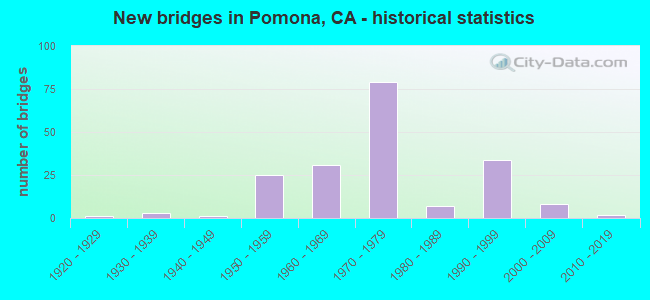
- New bridges - historical statistics
- 11920-1929
- 31930-1939
- 11940-1949
- 251950-1959
- 311960-1969
- 791970-1979
- 71980-1989
- 341990-1999
- 82000-2009
- 22010-2019

- Reconstructed bridges - Historical Statistics
- 11930-1939
- 01940-1949
- 01950-1959
- 21960-1969
- 51970-1979
- 01980-1989
- 111990-1999
- 02000-2009
- 32010-2019


- Bridge Condition - Deck
- 62.7%Good
- 4.8%Satisfactory
- 32.5%Fair

- Bridge Condition - Superstructure
- 1.2%Very good
- 83.3%Good
- 2.4%Satisfactory
- 13.1%Fair

- Bridge Condition - Substructure
- 97.6%Good
- 2.4%Satisfactory

- Bridge Condition - Channel
- 62.5%Excellent
- 35.0%Very good
- 2.5%Satisfactory

- Bridge Condition - Culverts
- 75.0%Good
- 25.0%Satisfactory
Find on map >> Show street view
Structure Number: 53 0049, Location: 07-LA-066-2.40-POM (Lat: 34.108511, Lng: -117.750972), Route carried "on" structure: State highway 66, Year Built: 1964, Year Reconstructed: 1970, Status: Open, Structure Length: 0.98m (3.22ft), Average Daily Traffic: 18,200 (year 2020), Truck Traffic: 3%, Average Future Daily Traffic: 29,832 (year 2037), Design Load: HS 20, Features Intersected: THOMPSON CREEK
Minimum Vertical Clearance: 30+ m (98+ ft), Kilometerpoint: 2.400, Lanes on structure: 5, Base Highway Network: Yes (, Subroute: 1), Owner: State Highway Agency, Approaching Roadway Width: 24.1m (79.1ft), Skew: 21 degrees, Material/Design: Concrete, Design/Construction: Slab, Number Of Spans In Main Unit: 1, Length of Maximum Span: 8.8m (28.9ft), Curb or Sidewalk Widths: Left: 2.1m (6.9ft), Right: 2.1m (6.9ft), Curb-To-Curb Width: 24.1m (79.1ft), Out-to-Out Width: 30.5m (100.1ft)
Condition: Deck: Good, Superstructure: Good, Substructure: Good, Channel: Very good, Operating Rating: 63.8 metric tons, Method Used To Determine Operating Rating: Load Factor (LF), Inventory Rating: 38.6 metric tons, Method Used To Determine Inventory Rating: Load Factor (LF), Structural Evaluation: Better than present minimum criteria, Deck Geometry: Superior to present desirable criteria, Waterway Adequacy: High priority of replacement, Approach Roadway Alignment: Equal to present desirable criteria, Designated Inspection Frequency: Every 48 months, Inspection Date: Febuary 2020, Deck Structure Type: Concrete Cast-file-Place, Wearing Surface/Protective System: Wearing Surface: Bituminous
Find on map >> Show street view
Structure Number: 53 0341, Location: 07-LA-001-7.11-LBCH (Lat: 33.790300, Lng: -118.204494), Route carried "on" structure: State highway 1, Year Built: 1957, Status: Open, Structure Length: 19.05m (62.50ft), Average Daily Traffic: 38,250 (year 2021), Truck Traffic: 11%, Average Future Daily Traffic: 77,684 (year 2039), Design Load: HS 20, Features Intersected: LOS ANGELES RIVER
Minimum Vertical Clearance: 30+ m (98+ ft), Kilometerpoint: 7.110, Lanes on structure: 5, Base Highway Network: Yes (, Subroute: 1), Owner: State Highway Agency, Approaching Roadway Width: 21.9m (71.9ft), Skew: 20 degrees, Material/Design: Concrete continuous, Design/Construction: Box Beam or Girders - Multiple, Number Of Spans In Main Unit: 7, Length of Maximum Span: 28.7m (94.2ft), Curb or Sidewalk Widths: Left: 1.5m (4.9ft), Right: 0.6m (2.0ft), Curb-To-Curb Width: 20.7m (67.9ft), Out-to-Out Width: 24.1m (79.1ft)
Condition: Deck: Good, Superstructure: Good, Substructure: Good, Channel: Very good, Operating Rating: 93.3 metric tons, Method Used To Determine Operating Rating: Load Factor (LF), Inventory Rating: 56.1 metric tons, Method Used To Determine Inventory Rating: Load Factor (LF), Structural Evaluation: Better than present minimum criteria, Deck Geometry: Somewhat better than minimum adequacy, Waterway Adequacy: Equal to present desirable criteria, Approach Roadway Alignment: Equal to present minimum criteria, Designated Inspection Frequency: Every 48 months, Inspection Date: October 2021, Deck Structure Type: Concrete Cast-file-Place
Find on map >> Show street view
Structure Number: 53 0345, Location: 07-LA-071-1.31-POM (Lat: 34.056994, Lng: -117.784819), Route carried "on" structure: State highway 71, Year Built: 1926, Year Reconstructed: 1939, Status: Open, Structure Length: 4.05m (13.29ft), Average Daily Traffic: 69,500 (year 2012), Average Future Daily Traffic: 157,883 (year 2040), Design Load: HS 15, Features Intersected: UP RR, AMTRAK, METROLINK
Minimum Vertical Clearance: 30+ m (98+ ft), Kilometerpoint: 1.310, Lanes on structure: 6, Base Highway Network: Yes (, Subroute: 1), Owner: State Highway Agency, Approaching Roadway Width: 21.9m (71.9ft), Skew: 33 degrees, Material/Design: Concrete continuous, Design/Construction: Tee Beam, Number Of Spans In Main Unit: 5, Length of Maximum Span: 11.6m (38.1ft), Curb or Sidewalk Widths: Left: 0.9m (3.0ft), Right: 0.9m (3.0ft), Curb-To-Curb Width: 21.9m (71.9ft), Out-to-Out Width: 25.0m (82.0ft)
Condition: Deck: Good, Superstructure: Good, Substructure: Good, Operating Rating: 54.1 metric tons, Method Used To Determine Operating Rating: Load Factor (LF), Inventory Rating: 32.4 metric tons, Method Used To Determine Inventory Rating: Load Factor (LF), Structural Evaluation: Better than present minimum criteria, Deck Geometry: High priority of replacement, Underclear: Meets minimum limits, Approach Roadway Alignment: Superior to present desirable criteria, Designated Inspection Frequency: Every 48 months, Inspection Date: December 2020, Deck Structure Type: Concrete Cast-file-Place, Wearing Surface/Protective System: Wearing Surface: Bituminous
Find on map >> Show street view
Structure Number: 53 0346, Location: 07-LA-071-1.20-POM (Lat: 34.058331, Lng: -117.786064), Route carried "on" structure: State highway 71, Year Built: 1939, Status: Open, Structure Length: 7.10m (23.29ft), Average Daily Traffic: 69,500 (year 2012), Average Future Daily Traffic: 157,883 (year 2040), Design Load: HS 15, Features Intersected: UP RR, AMTRAK, METROLINK
Minimum Vertical Clearance: 30+ m (98+ ft), Kilometerpoint: 1.200, Lanes on structure: 4, Lanes under structure: 2, Base Highway Network: Yes (, Subroute: 1), Owner: State Highway Agency, Approaching Roadway Width: 15.8m (51.8ft), Skew: 33 degrees, Material/Design: Concrete continuous, Design/Construction: Tee Beam, Number Of Spans In Main Unit: 7, Length of Maximum Span: 16.2m (53.1ft), Curb or Sidewalk Widths: Left: 0.9m (3.0ft), Right: 0.9m (3.0ft), Curb-To-Curb Width: 15.8m (51.8ft), Out-to-Out Width: 18.9m (62.0ft)
Condition: Deck: Fair, Superstructure: Good, Substructure: Good, Operating Rating: 25.9 metric tons, Method Used To Determine Operating Rating: Load and Resistance Factor Rating (LRFR) rating reported by rating factor(RF) method using HL-93 loadings, Inventory Rating: 19.8 metric tons, Method Used To Determine Inventory Rating: Load and Resistance Factor Rating (LRFR) rating reported by rating factor(RF) method using HL-93 loadings, Structural Evaluation: Somewhat better than minimum adequacy, Deck Geometry: Meets minimum limits, Underclear: High priority of corrective action, Approach Roadway Alignment: Superior to present desirable criteria, Designated Inspection Frequency: Every 24 months, Inspection Date: December 2020, Deck Structure Type: Concrete Cast-file-Place
Find on map >> Show street view
Structure Number: 53 0605M, Location: 07-LA-071-1.90-POM (Lat: 34.050353, Lng: -117.778194), Route carried "on" structure: State highway 71, Year Built: 1958, Status: Open, Structure Length: 0.70m (2.30ft), Average Daily Traffic: 72,000 (year 2012), Truck Traffic: 6%, Average Future Daily Traffic: 142,173 (year 2042), Design Load: HS 20, Features Intersected: 9TH ST STORM DRAIN (N)
Minimum Vertical Clearance: 30+ m (98+ ft), Kilometerpoint: 1.900, Lanes on structure: 6, Base Highway Network: Yes (, Subroute: 1), Owner: State Highway Agency, Approaching Roadway Width: 27.4m (89.9ft), Skew: 20 degrees, Material/Design: Concrete continuous, Design/Construction: Culvert, Number Of Spans In Main Unit: 5, Length of Maximum Span: 1.5m (4.9ft), Curb-To-Curb Width: 28.7m (94.2ft), Out-to-Out Width: 29.3m (96.1ft)
Condition: Channel: Very good, Culverts: Good, Operating Rating: 54.1 metric tons, Method Used To Determine Operating Rating: Field evaluation and documented engineering judgment, Inventory Rating: 32.4 metric tons, Method Used To Determine Inventory Rating: Field evaluation and documented engineering judgment, Structural Evaluation: Better than present minimum criteria, Deck Geometry: Better than present minimum criteria, Waterway Adequacy: Equal to present desirable criteria, Approach Roadway Alignment: Superior to present desirable criteria, Designated Inspection Frequency: Every 48 months, Inspection Date: December 2020
Find on map >> Show street view
Structure Number: 53 085, Location: 07-LA-710-22.41-CMRC (Lat: 34.003958, Lng: -118.172983), Route carried "on" structure: Interstate 710, Year Built: 1954, Status: Open, Structure Length: 0.76m (2.49ft), Average Daily Traffic: 217,000 (year 2017), Truck Traffic: 9%, Average Future Daily Traffic: 225,835 (year 2037), Design Load: HS 20, Features Intersected: BNSF RY,AMTRAK,METROLINK
Minimum Vertical Clearance: 30+ m (98+ ft), Kilometerpoint: 22.410, Lanes on structure: 8, Base Highway Network: Yes (Inventory Route: 7, Subroute: 1), Owner: State Highway Agency, Approaching Roadway Width: 39.9m (130.9ft), Skew: 30 degrees, Material/Design: Concrete, Design/Construction: Slab, Number Of Spans In Main Unit: 1, Length of Maximum Span: 7.0m (23.0ft), Curb-To-Curb Width: 39.9m (130.9ft), Out-to-Out Width: 48.8m (160.1ft)
Condition: Deck: Good, Superstructure: Good, Substructure: Good, Operating Rating: 99.8 metric tons, Method Used To Determine Operating Rating: Load Factor (LF), Inventory Rating: 99.8 metric tons, Method Used To Determine Inventory Rating: Load Factor (LF), Structural Evaluation: Better than present minimum criteria, Deck Geometry: Superior to present desirable criteria, Underclear: Meets minimum limits, Approach Roadway Alignment: Meets minimum limits, Designated Inspection Frequency: Every 24 months, Inspection Date: July 2020
Find on map >> Show street view
Structure Number: 53 0851, Location: 07-LA-010-44.19-POM (Lat: 34.073306, Lng: -117.778272), Route carried "on" structure: City street , Year Built: 1969, Status: Open, Structure Length: 8.22m (26.97ft), Average Daily Traffic: 6,100 (year 2011), Truck Traffic: 4%, Average Future Daily Traffic: 9,068 (year 2040), Design Load: HS 20, Features Intersected: INTERSTATE 10 AND RAMPS, Facility Carried by Structure: DUDLEY STREET
Minimum Vertical Clearance: 30+ m (98+ ft), Kilometerpoint: 0.000, Lanes on structure: 2, Lanes under structure: 13, Owner: State Highway Agency, Approaching Roadway Width: 15.9m (52.2ft), Skew: 1 degrees, Material/Design: Prestressed concrete continuous, Design/Construction: Stringer/Multi-beam, Number Of Spans In Main Unit: 3, Length of Maximum Span: 33.5m (109.9ft), Curb or Sidewalk Widths: Left: 1.8m (5.9ft), Right: 1.8m (5.9ft), Curb-To-Curb Width: 15.9m (52.2ft), Out-to-Out Width: 20.1m (65.9ft)
Condition: Deck: Good, Superstructure: Good, Substructure: Good, Operating Rating: 39.2 metric tons, Method Used To Determine Operating Rating: Load and Resistance Factor Rating (LRFR) rating reported by rating factor(RF) method using HL-93 loadings, Inventory Rating: 25.6 metric tons, Method Used To Determine Inventory Rating: Load and Resistance Factor Rating (LRFR) rating reported by rating factor(RF) method using HL-93 loadings, Structural Evaluation: Equal to present minimum criteria, Deck Geometry: Superior to present desirable criteria, Underclear: Somewhat better than minimum adequacy, Approach Roadway Alignment: Equal to present desirable criteria, Designated Inspection Frequency: Every 24 months, Inspection Date: September 2021, Deck Structure Type: Concrete Cast-file-Place, Wearing Surface/Protective System: Wearing Surface: Monolithic Concrete
Find on map >> Show street view
Structure Number: 53 0853, Location: 07-LA-010-45.28-POM (Lat: 34.070969, Lng: -117.759511), Route carried "on" structure: Interstate 10, Year Built: 1954, Year Reconstructed: 2004, Status: Open, Structure Length: 3.35m (10.99ft), Average Daily Traffic: 247,000 (year 2012), Truck Traffic: 7%, Average Future Daily Traffic: 275,377 (year 2039), Design Load: HS 20, Features Intersected: WHITE AVENUE
Minimum Vertical Clearance: 30+ m (98+ ft), Kilometerpoint: 45.280, Lanes on structure: 10, Lanes under structure: 4, Base Highway Network: Yes (, Subroute: 1), Owner: State Highway Agency, Approaching Roadway Width: 48.8m (160.1ft), Skew: 31 degrees, Material/Design: Prestressed concrete, Design/Construction: Box Beam or Girders - Multiple, Number Of Spans In Main Unit: 1, Length of Maximum Span: 32.0m (105.0ft), Curb-To-Curb Width: 48.8m (160.1ft), Out-to-Out Width: 50.3m (165.0ft)
Condition: Deck: Good, Superstructure: Good, Substructure: Good, Operating Rating: 99.8 metric tons, Method Used To Determine Operating Rating: Load Factor (LF), Inventory Rating: 32.6 metric tons, Method Used To Determine Inventory Rating: Load Factor (LF), Structural Evaluation: Better than present minimum criteria, Deck Geometry: Superior to present desirable criteria, Underclear: Somewhat better than minimum adequacy, Approach Roadway Alignment: Equal to present desirable criteria, Designated Inspection Frequency: Every 24 months, Inspection Date: September 2021, Deck Structure Type: Concrete Cast-file-Place, Wearing Surface/Protective System: Wearing Surface: Bituminous
Find on map >> Show street view
Structure Number: 53 0854, Location: 07-LA-010-45.55-POM (Lat: 34.072406, Lng: -117.755256), Route carried "on" structure: Interstate 10, Year Built: 1954, Year Reconstructed: 2003, Status: Open, Structure Length: 2.80m (9.19ft), Average Daily Traffic: 247,000 (year 2012), Truck Traffic: 7%, Average Future Daily Traffic: 275,377 (year 2039), Design Load: HS 20, Features Intersected: PARK AVENUE
Minimum Vertical Clearance: 30+ m (98+ ft), Kilometerpoint: 45.550, Lanes on structure: 11, Lanes under structure: 4, Base Highway Network: Yes (, Subroute: 1), Owner: State Highway Agency, Approaching Roadway Width: 51.8m (169.9ft), Skew: 32 degrees, Material/Design: Prestressed concrete, Design/Construction: Box Beam or Girders - Multiple, Number Of Spans In Main Unit: 1, Length of Maximum Span: 27.3m (89.6ft), Curb-To-Curb Width: 51.8m (169.9ft), Out-to-Out Width: 53.3m (174.9ft)
Condition: Deck: Good, Superstructure: Good, Substructure: Good, Operating Rating: 74.8 metric tons, Method Used To Determine Operating Rating: Load Factor (LF), Inventory Rating: 32.4 metric tons, Method Used To Determine Inventory Rating: Load Factor (LF), Structural Evaluation: Better than present minimum criteria, Deck Geometry: Superior to present desirable criteria, Underclear: Equal to present minimum criteria, Approach Roadway Alignment: Equal to present desirable criteria, Designated Inspection Frequency: Every 24 months, Inspection Date: September 2021, Deck Structure Type: Concrete Cast-file-Place, Wearing Surface/Protective System: Wearing Surface: Bituminous
Find on map >> Show street view
Structure Number: 53 0855, Location: 07-LA-010-45.73-POM (Lat: 34.073564, Lng: -117.752386), Route carried "on" structure: Interstate 10, Year Built: 1954, Year Reconstructed: 2004, Status: Open, Structure Length: 25.15m (82.51ft), Average Daily Traffic: 247,000 (year 2012), Truck Traffic: 7%, Average Future Daily Traffic: 275,377 (year 2039), Design Load: HS 20, Features Intersected: GAREY, ORANGE, MC KINLEY
Minimum Vertical Clearance: 30+ m (98+ ft), Kilometerpoint: 45.730, Lanes on structure: 10, Lanes under structure: 12, Base Highway Network: Yes (, Subroute: 1), Owner: State Highway Agency, Approaching Roadway Width: 48.4m (158.8ft), Skew: 39 degrees, Material/Design: Prestressed concrete, Design/Construction: Box Beam or Girders - Multiple, Number Of Spans In Main Unit: 10, Length of Maximum Span: 31.4m (103.0ft), Curb-To-Curb Width: 48.4m (158.8ft), Out-to-Out Width: 50.2m (164.7ft)
Condition: Deck: Fair, Superstructure: Good, Substructure: Good, Operating Rating: 61.6 metric tons, Method Used To Determine Operating Rating: Load Factor (LF), Inventory Rating: 32.6 metric tons, Method Used To Determine Inventory Rating: Load Factor (LF), Structural Evaluation: Better than present minimum criteria, Deck Geometry: Superior to present desirable criteria, Underclear: Meets minimum limits, Approach Roadway Alignment: Superior to present desirable criteria, Designated Inspection Frequency: Every 24 months, Inspection Date: September 2021, Deck Structure Type: Concrete Cast-file-Place, Wearing Surface/Protective System: Wearing Surface: Bituminous
Find on map >> Show street view
Structure Number: 53 0858, Location: 07-LA-010-46.40-POM (Lat: 34.077883, Lng: -117.741897), Route carried "on" structure: Interstate 10, Year Built: 1954, Year Reconstructed: 2003, Status: Open, Structure Length: 4.81m (15.78ft), Average Daily Traffic: 247,000 (year 2012), Truck Traffic: 7%, Average Future Daily Traffic: 275,377 (year 2038), Design Load: HS 20, Features Intersected: TOWNE AVENUE
Minimum Vertical Clearance: 30+ m (98+ ft), Kilometerpoint: 46.400, Lanes on structure: 10, Lanes under structure: 6, Base Highway Network: Yes (, Subroute: 1), Owner: State Highway Agency, Approaching Roadway Width: 48.8m (160.1ft), Skew: 34 degrees, Material/Design: Concrete continuous, Design/Construction: Box Beam or Girders - Multiple, Number Of Spans In Main Unit: 2, Length of Maximum Span: 23.1m (75.8ft), Curb-To-Curb Width: 48.8m (160.1ft), Out-to-Out Width: 50.3m (165.0ft)
Condition: Deck: Good, Superstructure: Good, Substructure: Good, Operating Rating: 79.1 metric tons, Method Used To Determine Operating Rating: Load Factor (LF), Inventory Rating: 47.6 metric tons, Method Used To Determine Inventory Rating: Load Factor (LF), Structural Evaluation: Better than present minimum criteria, Deck Geometry: Superior to present desirable criteria, Underclear: Equal to present minimum criteria, Approach Roadway Alignment: Equal to present desirable criteria, Designated Inspection Frequency: Every 24 months, Inspection Date: September 2021, Deck Structure Type: Concrete Cast-file-Place, Wearing Surface/Protective System: Wearing Surface: Bituminous
Find on map >> Show street view
Structure Number: 53 0859, Location: 07-LA-010-46.72-POM (Lat: 34.079950, Lng: -117.736875), Route carried "on" structure: Interstate 10, Year Built: 1954, Year Reconstructed: 2004, Status: Open, Structure Length: 2.83m (9.28ft), Average Daily Traffic: 247,000 (year 2012), Truck Traffic: 7%, Average Future Daily Traffic: 275,377 (year 2038), Design Load: HS 20, Features Intersected: SAN ANTONIO AVE
Minimum Vertical Clearance: 30+ m (98+ ft), Kilometerpoint: 46.720, Lanes on structure: 10, Lanes under structure: 2, Base Highway Network: Yes (, Subroute: 1), Owner: State Highway Agency, Approaching Roadway Width: 48.7m (159.8ft), Skew: 32 degrees, Material/Design: Concrete, Design/Construction: Box Beam or Girders - Multiple, Number Of Spans In Main Unit: 1, Length of Maximum Span: 27.7m (90.9ft), Curb-To-Curb Width: 48.7m (159.8ft), Out-to-Out Width: 50.4m (165.4ft)
Condition: Deck: Good, Superstructure: Good, Substructure: Good, Operating Rating: 99.8 metric tons, Method Used To Determine Operating Rating: Load Factor (LF), Inventory Rating: 32.6 metric tons, Method Used To Determine Inventory Rating: Load Factor (LF), Structural Evaluation: Better than present minimum criteria, Deck Geometry: Superior to present desirable criteria, Underclear: Somewhat better than minimum adequacy, Approach Roadway Alignment: Equal to present desirable criteria, Designated Inspection Frequency: Every 24 months, Inspection Date: September 2021, Deck Structure Type: Concrete Cast-file-Place, Wearing Surface/Protective System: Wearing Surface: Bituminous
Find on map >> Show street view
Structure Number: 53 0874, Location: 07-LA-010-43.66-POM (Lat: 34.073064, Lng: -117.787567), Route carried "on" structure: City street , Year Built: 1969, Status: Open, Structure Length: 6.74m (22.11ft), Average Daily Traffic: 16,000 (year 2011), Truck Traffic: 4%, Average Future Daily Traffic: 17,517 (year 2040), Design Load: HS 20+Mod, Features Intersected: INTERSTATE 10, Facility Carried by Structure: FAIRPLEX DRIVE
Minimum Vertical Clearance: 30+ m (98+ ft), Kilometerpoint: 0.000, Lanes on structure: 7, Lanes under structure: 10, Owner: State Highway Agency, Approaching Roadway Width: 24.4m (80.1ft), Skew: 3 degrees, Material/Design: Prestressed concrete continuous, Design/Construction: Stringer/Multi-beam, Number Of Spans In Main Unit: 2, Length of Maximum Span: 33.5m (109.9ft), Curb or Sidewalk Widths: Left: 0.6m (2.0ft), Right: 1.8m (5.9ft), Curb-To-Curb Width: 24.4m (80.1ft), Out-to-Out Width: 27.4m (89.9ft)
Condition: Deck: Fair, Superstructure: Good, Substructure: Good, Operating Rating: 47.0 metric tons, Method Used To Determine Operating Rating: Load and Resistance Factor Rating (LRFR) rating reported by rating factor(RF) method using HL-93 loadings, Inventory Rating: 29.5 metric tons, Method Used To Determine Inventory Rating: Load and Resistance Factor Rating (LRFR) rating reported by rating factor(RF) method using HL-93 loadings, Structural Evaluation: Better than present minimum criteria, Deck Geometry: High priority of replacement, Underclear: Meets minimum limits, Approach Roadway Alignment: Equal to present desirable criteria, Designated Inspection Frequency: Every 24 months, Inspection Date: September 2021, Deck Structure Type: Concrete Cast-file-Place
Find on map >> Show street view
Structure Number: 53 115, Location: 07-LA-710-23.77-LA (Lat: 34.023467, Lng: -118.172400), Route carried "on" structure: Interstate 710, Year Built: 1960, Year Reconstructed: 1967, Status: Open, Structure Length: 2.67m (8.76ft), Average Daily Traffic: 192,000 (year 2017), Truck Traffic: 7%, Average Future Daily Traffic: 206,537 (year 2037), Design Load: HS 20, Features Intersected: WHITTIER BLVD
Minimum Vertical Clearance: 30+ m (98+ ft), Kilometerpoint: 23.770, Lanes on structure: 9, Lanes under structure: 4, Base Highway Network: Yes (Inventory Route: 7, Subroute: 1), Owner: State Highway Agency, Approaching Roadway Width: 48.3m (158.5ft), Skew: 30 degrees, Material/Design: Steel, Design/Construction: Stringer/Multi-beam, Number Of Spans In Main Unit: 1, Length of Maximum Span: 25.0m (82.0ft), Curb-To-Curb Width: 48.3m (158.5ft), Out-to-Out Width: 50.7m (166.3ft)
Condition: Deck: Fair, Superstructure: Good, Substructure: Good, Operating Rating: 70.3 metric tons, Method Used To Determine Operating Rating: Load Factor (LF), Inventory Rating: 42.1 metric tons, Method Used To Determine Inventory Rating: Load Factor (LF), Structural Evaluation: Better than present minimum criteria, Deck Geometry: Superior to present desirable criteria, Underclear: Equal to present minimum criteria, Approach Roadway Alignment: Better than present minimum criteria, Designated Inspection Frequency: Every 24 months, Inspection Date: August 2020, Deck Structure Type: Concrete Cast-file-Place
Find on map >> Show street view
Structure Number: 53 1463, Location: 07-LA-071-R3.88-POM (Lat: 34.027564, Lng: -117.752886), Route carried "on" structure: State highway 71, Year Built: 1958, Year Reconstructed: 1982, Status: Open, Structure Length: 0.76m (2.49ft), Average Daily Traffic: 72,000 (year 2009), Truck Traffic: 6%, Average Future Daily Traffic: 142,173 (year 2037), Features Intersected: PHILADELPHIA ST STM DRN
Minimum Vertical Clearance: 30+ m (98+ ft), Kilometerpoint: 3.880, Lanes on structure: 4, Base Highway Network: Yes (, Subroute: 1), Owner: State Highway Agency, Approaching Roadway Width: 26.2m (86.0ft), Skew: 3 degrees, Material/Design: Concrete, Design/Construction: Culvert, Number Of Spans In Main Unit: 3, Length of Maximum Span: 2.7m (8.9ft), Curb-To-Curb Width: 27.7m (90.9ft), Out-to-Out Width: 27.7m (90.9ft)
Condition: Channel: Very good, Culverts: Good, Operating Rating: 54.1 metric tons, Method Used To Determine Operating Rating: Field evaluation and documented engineering judgment, Inventory Rating: 32.4 metric tons, Method Used To Determine Inventory Rating: Field evaluation and documented engineering judgment, Structural Evaluation: Better than present minimum criteria, Deck Geometry: Superior to present desirable criteria, Waterway Adequacy: Equal to present desirable criteria, Approach Roadway Alignment: Superior to present desirable criteria, Designated Inspection Frequency: Every 48 months, Inspection Date: July 2019
Find on map >> Show street view
Structure Number: 53 1825, Location: 07-LA-010-44.84-POM (Lat: 34.071214, Lng: -117.766897), Route carried "on" structure: Interstate 10, Year Built: 1963, Year Reconstructed: 2004, Status: Open, Structure Length: 0.85m (2.79ft), Average Daily Traffic: 247,000 (year 2012), Truck Traffic: 7%, Average Future Daily Traffic: 275,377 (year 2040), Features Intersected: SAN JOSE WASH
Minimum Vertical Clearance: 30+ m (98+ ft), Kilometerpoint: 44.840, Lanes on structure: 10, Base Highway Network: Yes (, Subroute: 1), Owner: State Highway Agency, Approaching Roadway Width: 56.1m (184.1ft), Skew: 35 degrees, Material/Design: Concrete, Design/Construction: Culvert, Number Of Spans In Main Unit: 1, Length of Maximum Span: 7.3m (24.0ft), Curb-To-Curb Width: 56.1m (184.1ft), Out-to-Out Width: 59.5m (195.2ft)
Condition: Channel: Very good, Culverts: Good, Operating Rating: 54.1 metric tons, Method Used To Determine Operating Rating: Field evaluation and documented engineering judgment, Inventory Rating: 32.4 metric tons, Method Used To Determine Inventory Rating: Field evaluation and documented engineering judgment, Structural Evaluation: Better than present minimum criteria, Deck Geometry: Superior to present desirable criteria, Waterway Adequacy: Equal to present desirable criteria, Approach Roadway Alignment: Equal to present desirable criteria, Designated Inspection Frequency: Every 24 months, Inspection Date: September 2021
Find on map >> Show street view
Structure Number: 53 1933, Location: 07-LA-057-R6.68-POM (Lat: 34.050825, Lng: -117.801772), Route carried "on" structure: State highway 57, Year Built: 1972, Status: Open, Structure Length: 5.01m (16.44ft), Average Daily Traffic: 158,000 (year 2012), Truck Traffic: 5%, Average Future Daily Traffic: 146,359 (year 2040), Design Load: HS 20+Mod, Features Intersected: UP RR & METROLINK
Minimum Vertical Clearance: 30+ m (98+ ft), Kilometerpoint: 6.680, Lanes on structure: 10, Base Highway Network: Yes (, Subroute: 1), Owner: State Highway Agency, Approaching Roadway Width: 51.8m (169.9ft), Skew: 33 degrees, Material/Design: Concrete continuous, Design/Construction: Box Beam or Girders - Multiple, Number Of Spans In Main Unit: 3, Length of Maximum Span: 21.9m (71.9ft), Curb-To-Curb Width: 51.8m (169.9ft), Out-to-Out Width: 52.4m (171.9ft)
Condition: Deck: Fair, Superstructure: Fair, Substructure: Good, Operating Rating: 68.0 metric tons, Method Used To Determine Operating Rating: Load and Resistance Factor Rating (LRFR) rating reported by rating factor(RF) method using HL-93 loadings, Inventory Rating: 49.2 metric tons, Method Used To Determine Inventory Rating: Load and Resistance Factor Rating (LRFR) rating reported by rating factor(RF) method using HL-93 loadings, Structural Evaluation: Somewhat better than minimum adequacy, Deck Geometry: Superior to present desirable criteria, Underclear: Meets minimum limits, Approach Roadway Alignment: Superior to present desirable criteria, Designated Inspection Frequency: Every 24 months, Inspection Date: August 2020, Deck Structure Type: Concrete Cast-file-Place
Find on map >> Show street view
Structure Number: 53 1934, Location: 07-LA-057-R7.14-POM (Lat: 34.057331, Lng: -117.803803), Route carried "on" structure: State highway 57, Year Built: 1972, Status: Open, Structure Length: 5.77m (18.93ft), Average Daily Traffic: 158,000 (year 2012), Truck Traffic: 5%, Average Future Daily Traffic: 146,359 (year 2040), Design Load: HS 20, Features Intersected: VALLEY BLVD
Minimum Vertical Clearance: 30+ m (98+ ft), Kilometerpoint: 7.140, Lanes on structure: 10, Lanes under structure: 4, Base Highway Network: Yes (, Subroute: 1), Owner: State Highway Agency, Approaching Roadway Width: 44.5m (146.0ft), Skew: 33 degrees, Material/Design: Prestressed concrete, Design/Construction: Box Beam or Girders - Multiple, Number Of Spans In Main Unit: 1, Length of Maximum Span: 56.7m (186.0ft), Curb-To-Curb Width: 51.2m (168.0ft), Out-to-Out Width: 52.4m (171.9ft)
Condition: Deck: Good, Superstructure: Good, Substructure: Good, Operating Rating: 78.7 metric tons, Method Used To Determine Operating Rating: Load and Resistance Factor Rating (LRFR) rating reported by rating factor(RF) method using HL-93 loadings, Inventory Rating: 52.8 metric tons, Method Used To Determine Inventory Rating: Load and Resistance Factor Rating (LRFR) rating reported by rating factor(RF) method using HL-93 loadings, Structural Evaluation: Better than present minimum criteria, Deck Geometry: Superior to present desirable criteria, Underclear: Better than present minimum criteria, Approach Roadway Alignment: Superior to present desirable criteria, Designated Inspection Frequency: Every 24 months, Inspection Date: August 2020, Deck Structure Type: Concrete Cast-file-Place
Find on map >> Show street view
Structure Number: 53 1935, Location: 07-LA-057-R7.09-POM (Lat: 34.056481, Lng: -117.803522), Route carried "on" structure: State highway 57, Year Built: 1972, Status: Open, Structure Length: 3.90m (12.80ft), Average Daily Traffic: 158,000 (year 2009), Truck Traffic: 5%, Average Future Daily Traffic: 146,359 (year 2035), Design Load: HS 20+Mod, Features Intersected: UP RR & METROLINK
Minimum Vertical Clearance: 30+ m (98+ ft), Kilometerpoint: 7.090, Lanes on structure: 10, Base Highway Network: Yes (, Subroute: 1), Owner: State Highway Agency, Approaching Roadway Width: 51.8m (169.9ft), Skew: 31 degrees, Material/Design: Concrete continuous, Design/Construction: Box Beam or Girders - Multiple, Number Of Spans In Main Unit: 3, Length of Maximum Span: 17.1m (56.1ft), Curb-To-Curb Width: 51.2m (168.0ft), Out-to-Out Width: 52.4m (171.9ft)
Condition: Deck: Good, Superstructure: Good, Substructure: Good, Operating Rating: 52.5 metric tons, Method Used To Determine Operating Rating: Load and Resistance Factor Rating (LRFR) rating reported by rating factor(RF) method using HL-93 loadings, Inventory Rating: 37.3 metric tons, Method Used To Determine Inventory Rating: Load and Resistance Factor Rating (LRFR) rating reported by rating factor(RF) method using HL-93 loadings, Structural Evaluation: Better than present minimum criteria, Deck Geometry: Superior to present desirable criteria, Underclear: Superior to present desirable criteria, Approach Roadway Alignment: Superior to present desirable criteria, Designated Inspection Frequency: Every 48 months, Inspection Date: August 2018, Deck Structure Type: Concrete Cast-file-Place, Wearing Surface/Protective System: Wearing Surface: Monolithic Concrete
Find on map >> Show street view
Structure Number: 53 1987F, Location: 07-LA-071-R0.58-POM (Lat: 34.066939, Lng: -117.803633), Route carried "on" structure: Ramp State highway 71, Year Built: 1972, Status: Open, Structure Length: 19.48m (63.91ft), Average Daily Traffic: 12,700 (year 2012), Average Future Daily Traffic: 14,426 (year 2038), Design Load: HS 20+Mod, Features Intersected: I 10 & CONN
Minimum Vertical Clearance: 7.62m (25.00ft), Kilometerpoint: 0.580, Lanes on structure: 2, Lanes under structure: 16, Base Highway Network: Yes, Owner: State Highway Agency, Approaching Roadway Width: 9.8m (32.2ft), Material/Design: Prestressed concrete continuous, Design/Construction: Box Beam or Girders - Multiple, Number Of Spans In Main Unit: 2, Number Of Approach Spans: 2, Length of Maximum Span: 56.1m (184.1ft), Curb-To-Curb Width: 9.8m (32.2ft), Out-to-Out Width: 10.4m (34.1ft)
Condition: Deck: Fair, Superstructure: Good, Substructure: Good, Operating Rating: 78.7 metric tons, Method Used To Determine Operating Rating: Load Factor (LF), Inventory Rating: 32.4 metric tons, Method Used To Determine Inventory Rating: Load Factor (LF), Structural Evaluation: Better than present minimum criteria, Deck Geometry: Equal to present minimum criteria, Underclear: Equal to present minimum criteria, Approach Roadway Alignment: Equal to present desirable criteria, Designated Inspection Frequency: Every 24 months, Inspection Date: December 2020, Deck Structure Type: Concrete Cast-file-Place
Find on map >> Show street view
Structure Number: 53 1990G, Location: 07-LA-005-R43.83 (Lat: 34.314453, Lng: -118.488161), Route carried "on" structure: Ramp Interstate 5, Year Built: 1975, Status: Open, Structure Length: 7.62m (25.00ft), Average Daily Traffic: 5,100 (year 2011), Truck Traffic: 3%, Average Future Daily Traffic: 6,716 (year 2041), Design Load: HS 20+Mod, Features Intersected: METROLINK,UP RR,SAN FERN
Minimum Vertical Clearance: 30+ m (98+ ft), Kilometerpoint: 43.830, Lanes on structure: 1, Lanes under structure: 4, Base Highway Network: Yes, Owner: State Highway Agency, Approaching Roadway Width: 10.3m (33.8ft), Material/Design: Prestressed concrete continuous, Design/Construction: Box Beam or Girders - Multiple, Number Of Spans In Main Unit: 2, Length of Maximum Span: 38.0m (124.7ft), Curb-To-Curb Width: 9.7m (31.8ft), Out-to-Out Width: 10.4m (34.1ft)
Condition: Deck: Good, Superstructure: Good, Substructure: Good, Operating Rating: 52.8 metric tons, Method Used To Determine Operating Rating: Load and Resistance Factor Rating (LRFR) rating reported by rating factor(RF) method using HL-93 loadings, Inventory Rating: 40.5 metric tons, Method Used To Determine Inventory Rating: Load and Resistance Factor Rating (LRFR) rating reported by rating factor(RF) method using HL-93 loadings, Structural Evaluation: Better than present minimum criteria, Deck Geometry: Superior to present desirable criteria, Underclear: High priority of corrective action, Approach Roadway Alignment: Equal to present desirable criteria, Designated Inspection Frequency: Every 24 months, Inspection Date: January 2021, Deck Structure Type: Concrete Cast-file-Place
Find on map >> Show street view
Structure Number: 53 1998, Location: 07-LA-057-R7.30-POM (Lat: 34.059394, Lng: -117.804522), Route carried "on" structure: State highway 57, Year Built: 1972, Status: Open, Structure Length: 9.11m (29.89ft), Average Daily Traffic: 158,000 (year 2012), Truck Traffic: 5%, Average Future Daily Traffic: 146,359 (year 2040), Design Load: HS 20+Mod, Features Intersected: SAN JOSE FLD CNTRL CHNNL
Minimum Vertical Clearance: 30+ m (98+ ft), Kilometerpoint: 7.300, Lanes on structure: 6, Lanes under structure: 5, Base Highway Network: Yes (, Subroute: 1), Owner: State Highway Agency, Approaching Roadway Width: 37.2m (122.0ft), Skew: 30 degrees, Material/Design: Prestressed concrete continuous, Design/Construction: Box Beam or Girders - Multiple, Number Of Spans In Main Unit: 2, Length of Maximum Span: 49.1m (161.1ft), Curb-To-Curb Width: 36.6m (120.1ft), Out-to-Out Width: 37.8m (124.0ft)
Condition: Deck: Good, Superstructure: Good, Substructure: Good, Channel: Very good, Operating Rating: 23.3 metric tons, Method Used To Determine Operating Rating: Load and Resistance Factor Rating (LRFR) rating reported by rating factor(RF) method using HL-93 loadings, Inventory Rating: 14.3 metric tons, Method Used To Determine Inventory Rating: Load and Resistance Factor Rating (LRFR) rating reported by rating factor(RF) method using HL-93 loadings, Structural Evaluation: High priority of corrective action, Deck Geometry: Superior to present desirable criteria, Underclear: Somewhat better than minimum adequacy, Waterway Adequacy: Equal to present desirable criteria, Approach Roadway Alignment: Superior to present desirable criteria, Designated Inspection Frequency: Every 24 months, Inspection Date: August 2020, Deck Structure Type: Concrete Cast-file-Place
Find on map >> Show street view
Structure Number: 53 1998G, Location: 07-LA-057-R7.33-POM (Lat: 34.059478, Lng: -117.804317), Route carried "on" structure: Ramp State highway 57, Year Built: 1972, Status: Open, Structure Length: 8.32m (27.30ft), Average Daily Traffic: 30,000 (year 2012), Truck Traffic: 4%, Average Future Daily Traffic: 44,307 (year 2040), Design Load: HS 20, Features Intersected: SAN JOSE FLD CNTRL CHNNL
Minimum Vertical Clearance: 30+ m (98+ ft), Kilometerpoint: 7.330, Lanes on structure: 2, Lanes under structure: 5, Base Highway Network: Yes (, Subroute: 1), Owner: State Highway Agency, Approaching Roadway Width: 11.9m (39.0ft), Material/Design: Prestressed concrete continuous, Design/Construction: Box Beam or Girders - Multiple, Number Of Spans In Main Unit: 2, Length of Maximum Span: 43.6m (143.0ft), Curb-To-Curb Width: 11.9m (39.0ft), Out-to-Out Width: 12.5m (41.0ft)
Condition: Deck: Good, Superstructure: Good, Substructure: Good, Channel: Very good, Operating Rating: 41.8 metric tons, Method Used To Determine Operating Rating: Load and Resistance Factor Rating (LRFR) rating reported by rating factor(RF) method using HL-93 loadings, Inventory Rating: 24.0 metric tons, Method Used To Determine Inventory Rating: Load and Resistance Factor Rating (LRFR) rating reported by rating factor(RF) method using HL-93 loadings, Structural Evaluation: Somewhat better than minimum adequacy, Deck Geometry: Superior to present desirable criteria, Underclear: Somewhat better than minimum adequacy, Waterway Adequacy: Equal to present desirable criteria, Approach Roadway Alignment: Superior to present desirable criteria, Designated Inspection Frequency: Every 24 months, Inspection Date: August 2020, Deck Structure Type: Concrete Cast-file-Place
Find on map >> Show street view
Structure Number: 53 1998H, Location: 07-LA-010-42.34-POM (Lat: 34.059975, Lng: -117.805408), Route carried "on" structure: Ramp Interstate 10, Year Built: 1972, Status: Open, Structure Length: 8.78m (28.81ft), Average Daily Traffic: 30,000 (year 2011), Truck Traffic: 4%, Average Future Daily Traffic: 44,307 (year 2038), Design Load: HS 20+Mod, Features Intersected: SAN JOSE WASH, CAMPUS DR
Minimum Vertical Clearance: 30+ m (98+ ft), Kilometerpoint: 42.340, Lanes on structure: 2, Lanes under structure: 4, Owner: State Highway Agency, Approaching Roadway Width: 11.9m (39.0ft), Material/Design: Prestressed concrete continuous, Design/Construction: Box Beam or Girders - Multiple, Number Of Spans In Main Unit: 2, Length of Maximum Span: 46.9m (153.9ft), Curb-To-Curb Width: 11.9m (39.0ft), Out-to-Out Width: 12.5m (41.0ft)
Condition: Deck: Good, Superstructure: Good, Substructure: Good, Channel: Very good, Operating Rating: 17.5 metric tons, Method Used To Determine Operating Rating: Load and Resistance Factor Rating (LRFR) rating reported by rating factor(RF) method using HL-93 loadings, Inventory Rating: 9.7 metric tons, Method Used To Determine Inventory Rating: Load and Resistance Factor Rating (LRFR) rating reported by rating factor(RF) method using HL-93 loadings, Structural Evaluation: High priority of corrective action, Deck Geometry: Superior to present desirable criteria, Underclear: Somewhat better than minimum adequacy, Waterway Adequacy: Equal to present desirable criteria, Approach Roadway Alignment: Superior to present desirable criteria, Designated Inspection Frequency: Every 24 months, Inspection Date: October 2021, Deck Structure Type: Concrete Cast-file-Place
Find on map >> Show street view
Structure Number: 53 1999L, Location: 07-LA-071-R0.52-POM (Lat: 34.067303, Lng: -117.804517), Route carried "on" structure: State highway 71, Year Built: 1972, Status: Open, Structure Length: 24.60m (80.71ft), Average Daily Traffic: 31,500 (year 2012), Average Future Daily Traffic: 51,660 (year 2040), Design Load: HS 20, Features Intersected: I 10 & CONN
Minimum Vertical Clearance: 30+ m (98+ ft), Kilometerpoint: 0.520, Lanes on structure: 2, Lanes under structure: 18, Base Highway Network: Yes (, Subroute: 1), Owner: State Highway Agency, Approaching Roadway Width: 14.9m (48.9ft), Skew: 3 degrees, Material/Design: Concrete continuous, Design/Construction: Box Beam or Girders - Multiple, Number Of Spans In Main Unit: 7, Length of Maximum Span: 40.8m (133.9ft), Curb-To-Curb Width: 11.9m (39.0ft), Out-to-Out Width: 12.5m (41.0ft)
Condition: Deck: Fair, Superstructure: Fair, Substructure: Good, Operating Rating: 99.8 metric tons, Method Used To Determine Operating Rating: Load Factor (LF), Inventory Rating: 78.1 metric tons, Method Used To Determine Inventory Rating: Load Factor (LF), Structural Evaluation: Somewhat better than minimum adequacy, Deck Geometry: Equal to present minimum criteria, Underclear: Somewhat better than minimum adequacy, Approach Roadway Alignment: Superior to present desirable criteria, Designated Inspection Frequency: Every 24 months, Inspection Date: December 2020, Deck Structure Type: Concrete Cast-file-Place
Find on map >> Show street view
Structure Number: 53 1999R, Location: 07-LA-071-R0.52-POM (Lat: 34.067208, Lng: -117.804808), Route carried "on" structure: State highway 71, Year Built: 1972, Status: Open, Structure Length: 25.05m (82.19ft), Average Daily Traffic: 31,500 (year 2012), Average Future Daily Traffic: 51,660 (year 2037), Design Load: HS 20, Features Intersected: I 10 & CONN
Minimum Vertical Clearance: 30+ m (98+ ft), Kilometerpoint: 0.520, Lanes on structure: 2, Lanes under structure: 18, Base Highway Network: Yes (, Subroute: 1), Owner: State Highway Agency, Approaching Roadway Width: 11.9m (39.0ft), Skew: 3 degrees, Material/Design: Concrete continuous, Design/Construction: Box Beam or Girders - Multiple, Number Of Spans In Main Unit: 7, Length of Maximum Span: 42.7m (140.1ft), Curb-To-Curb Width: 11.9m (39.0ft), Out-to-Out Width: 12.5m (41.0ft)
Condition: Deck: Fair, Superstructure: Good, Substructure: Good, Operating Rating: 99.8 metric tons, Method Used To Determine Operating Rating: Load Factor (LF), Inventory Rating: 71.3 metric tons, Method Used To Determine Inventory Rating: Load Factor (LF), Structural Evaluation: Better than present minimum criteria, Deck Geometry: Equal to present minimum criteria, Underclear: Somewhat better than minimum adequacy, Approach Roadway Alignment: Superior to present desirable criteria, Designated Inspection Frequency: Every 24 months, Inspection Date: December 2020, Deck Structure Type: Concrete Cast-file-Place
Find on map >> Show street view
Structure Number: 53 2001F, Location: 07-LA-057-R7.72-POM (Lat: 34.065542, Lng: -117.804197), Route carried "on" structure: Ramp State highway 57, Year Built: 1972, Status: Open, Structure Length: 4.15m (13.62ft), Average Daily Traffic: 27,200 (year 2012), Truck Traffic: 2%, Average Future Daily Traffic: 31,535 (year 2040), Design Load: HS 20, Features Intersected: N57-E10 CONNECTOR RAMP
Minimum Vertical Clearance: 30+ m (98+ ft), Kilometerpoint: 7.720, Lanes on structure: 2, Lanes under structure: 10, Base Highway Network: Yes (, Subroute: 1), Owner: State Highway Agency, Approaching Roadway Width: 9.8m (32.2ft), Skew: 9 degrees, Material/Design: Prestressed concrete, Design/Construction: Box Beam or Girders - Multiple, Number Of Spans In Main Unit: 1, Length of Maximum Span: 40.5m (132.9ft), Curb-To-Curb Width: 9.8m (32.2ft), Out-to-Out Width: 10.4m (34.1ft)
Condition: Deck: Good, Superstructure: Fair, Substructure: Good, Operating Rating: 65.8 metric tons, Method Used To Determine Operating Rating: Load and Resistance Factor Rating (LRFR) rating reported by rating factor(RF) method using HL-93 loadings, Inventory Rating: 50.9 metric tons, Method Used To Determine Inventory Rating: Load and Resistance Factor Rating (LRFR) rating reported by rating factor(RF) method using HL-93 loadings, Structural Evaluation: Somewhat better than minimum adequacy, Deck Geometry: Equal to present minimum criteria, Underclear: Better than present minimum criteria, Approach Roadway Alignment: Equal to present desirable criteria, Designated Inspection Frequency: Every 24 months, Inspection Date: September 2020, Deck Structure Type: Concrete Cast-file-Place
Find on map >> Show street view
Structure Number: 53 2003, Location: 07-LA-057-R7.66-POM (Lat: 34.064464, Lng: -117.806100), Route carried "on" structure: State highway 57, Year Built: 1972, Status: Open, Structure Length: 19.84m (65.09ft), Average Daily Traffic: 158,000 (year 2012), Truck Traffic: 5%, Average Future Daily Traffic: 146,359 (year 2040), Design Load: HS 20, Features Intersected: INTERSTATE 10 & E10-S71
Minimum Vertical Clearance: 30+ m (98+ ft), Kilometerpoint: 7.660, Lanes on structure: 6, Lanes under structure: 17, Base Highway Network: Yes (, Subroute: 1), Owner: State Highway Agency, Approaching Roadway Width: 37.2m (122.0ft), Skew: 39 degrees, Material/Design: Concrete continuous, Design/Construction: Box Beam or Girders - Multiple, Number Of Spans In Main Unit: 6, Length of Maximum Span: 38.4m (126.0ft), Curb-To-Curb Width: 36.6m (120.1ft), Out-to-Out Width: 37.8m (124.0ft)
Condition: Deck: Good, Superstructure: Good, Substructure: Good, Operating Rating: 54.1 metric tons, Method Used To Determine Operating Rating: Field evaluation and documented engineering judgment, Inventory Rating: 32.4 metric tons, Method Used To Determine Inventory Rating: Field evaluation and documented engineering judgment, Structural Evaluation: Better than present minimum criteria, Deck Geometry: Superior to present desirable criteria, Underclear: High priority of corrective action, Approach Roadway Alignment: Superior to present desirable criteria, Designated Inspection Frequency: Every 24 months, Inspection Date: August 2020, Deck Structure Type: Concrete Cast-file-Place
Find on map >> Show street view
Structure Number: 53 2004G, Location: 07-LA-010-42.44-POM (Lat: 34.064369, Lng: -117.807211), Route carried "on" structure: Ramp Interstate 10, Year Built: 1972, Status: Open, Structure Length: 21.56m (70.73ft), Average Daily Traffic: 5,000 (year 2012), Truck Traffic: 4%, Average Future Daily Traffic: 5,235 (year 2040), Design Load: HS 20, Features Intersected: INTERSTATE 10 AND RAMPS
Minimum Vertical Clearance: 6.17m (20.24ft), Kilometerpoint: 42.440, Lanes on structure: 2, Lanes under structure: 17, Owner: State Highway Agency, Approaching Roadway Width: 9.8m (32.2ft), Skew: 9 degrees, Material/Design: Concrete continuous, Design/Construction: Box Beam or Girders - Multiple, Number Of Spans In Main Unit: 6, Length of Maximum Span: 47.5m (155.8ft), Curb-To-Curb Width: 9.8m (32.2ft), Out-to-Out Width: 10.4m (34.1ft)
Condition: Deck: Fair, Superstructure: Good, Substructure: Good, Operating Rating: 99.8 metric tons, Method Used To Determine Operating Rating: Load Factor (LF), Inventory Rating: 66.1 metric tons, Method Used To Determine Inventory Rating: Load Factor (LF), Structural Evaluation: Better than present minimum criteria, Deck Geometry: Equal to present minimum criteria, Underclear: Meets minimum limits, Approach Roadway Alignment: Equal to present minimum criteria, Designated Inspection Frequency: Every 24 months, Inspection Date: October 2021, Deck Structure Type: Concrete Cast-file-Place
Find on map >> Show street view
Structure Number: 53 2006G, Location: 07-LA-057-R7.66-POM (Lat: 34.064739, Lng: -117.805942), Route carried "on" structure: Ramp State highway 57, Year Built: 1972, Status: Open, Structure Length: 18.48m (60.63ft), Average Daily Traffic: 11,300 (year 2012), Truck Traffic: 4%, Average Future Daily Traffic: 14,334 (year 2040), Design Load: HS 20, Features Intersected: INTERSTATE 10 & CONNS
Minimum Vertical Clearance: 5.56m (18.24ft), Kilometerpoint: 7.660, Lanes on structure: 2, Lanes under structure: 13, Base Highway Network: Yes (, Subroute: 1), Owner: State Highway Agency, Approaching Roadway Width: 9.8m (32.2ft), Skew: 9 degrees, Material/Design: Concrete continuous, Design/Construction: Box Beam or Girders - Multiple, Number Of Spans In Main Unit: 6, Length of Maximum Span: 39.3m (128.9ft), Curb-To-Curb Width: 9.8m (32.2ft), Out-to-Out Width: 10.4m (34.1ft)
Condition: Deck: Good, Superstructure: Good, Substructure: Good, Operating Rating: 99.8 metric tons, Method Used To Determine Operating Rating: Load Factor (LF), Inventory Rating: 61.6 metric tons, Method Used To Determine Inventory Rating: Load Factor (LF), Structural Evaluation: Better than present minimum criteria, Deck Geometry: Equal to present minimum criteria, Underclear: High priority of corrective action, Approach Roadway Alignment: Superior to present desirable criteria, Designated Inspection Frequency: Every 24 months, Inspection Date: September 2020, Deck Structure Type: Concrete Cast-file-Place
Find on map >> Show street view
Structure Number: 53 2007F, Location: 07-LA-010-42.45-POM (Lat: 34.064403, Lng: -117.806619), Route carried "on" structure: Ramp Interstate 10, Year Built: 1972, Status: Open, Structure Length: 27.30m (89.57ft), Average Daily Traffic: 35,000 (year 2014), Truck Traffic: 4%, Average Future Daily Traffic: 51,932 (year 2040), Design Load: HS 20, Features Intersected: INTERSTATE 10 AND RAMPS
Minimum Vertical Clearance: 6.43m (21.10ft), Kilometerpoint: 42.450, Lanes on structure: 2, Lanes under structure: 17, Owner: State Highway Agency, Approaching Roadway Width: 11.9m (39.0ft), Skew: 9 degrees, Material/Design: Concrete continuous, Design/Construction: Box Beam or Girders - Multiple, Number Of Spans In Main Unit: 7, Length of Maximum Span: 48.2m (158.1ft), Curb-To-Curb Width: 11.9m (39.0ft), Out-to-Out Width: 12.5m (41.0ft)
Condition: Deck: Fair, Superstructure: Good, Substructure: Good, Operating Rating: 53.5 metric tons, Method Used To Determine Operating Rating: Load Factor (LF), Inventory Rating: 32.4 metric tons, Method Used To Determine Inventory Rating: Load Factor (LF), Structural Evaluation: Better than present minimum criteria, Deck Geometry: Superior to present desirable criteria, Underclear: Meets minimum limits, Approach Roadway Alignment: Meets minimum limits, Designated Inspection Frequency: Every 24 months, Inspection Date: October 2021, Deck Structure Type: Concrete Cast-file-Place
Find on map >> Show street view
Structure Number: 53 2008, Location: 07-LA-010-42.10-POM (Lat: 34.063725, Lng: -117.812111), Route carried "on" structure: Interstate 10, Year Built: 1972, Year Reconstructed: 2019, Status: Open, Structure Length: 2.77m (9.09ft), Average Daily Traffic: 209,000 (year 2014), Average Future Daily Traffic: 266,494 (year 2040), Design Load: HS 20, Features Intersected: KELLOGG DRIVE
Minimum Vertical Clearance: 30+ m (98+ ft), Kilometerpoint: 42.100, Lanes on structure: 9, Lanes under structure: 4, Base Highway Network: Yes (, Subroute: 1), Owner: State Highway Agency, Approaching Roadway Width: 43.7m (143.4ft), Skew: 20 degrees, Material/Design: Prestressed concrete, Design/Construction: Box Beam or Girders - Multiple, Number Of Spans In Main Unit: 1, Length of Maximum Span: 27.4m (89.9ft), Curb-To-Curb Width: 43.7m (143.4ft), Out-to-Out Width: 45.1m (148.0ft)
Condition: Deck: Good, Superstructure: Good, Substructure: Good, Operating Rating: 80.0 metric tons, Method Used To Determine Operating Rating: Load Factor (LF), Inventory Rating: 32.4 metric tons, Method Used To Determine Inventory Rating: Load Factor (LF), Structural Evaluation: Better than present minimum criteria, Deck Geometry: Superior to present desirable criteria, Underclear: Meets minimum limits, Approach Roadway Alignment: Equal to present desirable criteria, Designated Inspection Frequency: Every 24 months, Inspection Date: October 2021, Deck Structure Type: Concrete Cast-file-Place
Find on map >> Show street view
Structure Number: 53 2008G, Location: 07-LA-010-42.10-POM (Lat: 34.063575, Lng: -117.812089), Route carried "on" structure: Ramp Interstate 10, Year Built: 1972, Year Reconstructed: 2019, Status: Open, Structure Length: 2.78m (9.12ft), Average Daily Traffic: 8,200 (year 2014), Truck Traffic: 2%, Average Future Daily Traffic: 8,552 (year 2040), Design Load: HS 20+Mod, Features Intersected: KELLOGG DR
Minimum Vertical Clearance: 30+ m (98+ ft), Kilometerpoint: 42.100, Lanes on structure: 1, Lanes under structure: 4, Owner: State Highway Agency, Approaching Roadway Width: 10.7m (35.1ft), Material/Design: Prestressed concrete, Design/Construction: Box Beam or Girders - Multiple, Number Of Spans In Main Unit: 1, Length of Maximum Span: 27.6m (90.6ft), Curb-To-Curb Width: 10.7m (35.1ft), Out-to-Out Width: 11.7m (38.4ft)
Condition: Deck: Good, Superstructure: Good, Substructure: Good, Operating Rating: 44.7 metric tons, Method Used To Determine Operating Rating: Load and Resistance Factor Rating (LRFR) rating reported by rating factor(RF) method using HL-93 loadings, Inventory Rating: 18.8 metric tons, Method Used To Determine Inventory Rating: Load and Resistance Factor Rating (LRFR) rating reported by rating factor(RF) method using HL-93 loadings, Structural Evaluation: Meets minimum limits, Deck Geometry: Superior to present desirable criteria, Underclear: Meets minimum limits, Approach Roadway Alignment: Equal to present desirable criteria, Designated Inspection Frequency: Every 24 months, Inspection Date: October 2021, Deck Structure Type: Concrete Cast-file-Place
Find on map >> Show street view
Structure Number: 53 2052, Location: 07-LA-071-R0.92-POM (Lat: 34.064836, Lng: -117.798039), Route carried "on" structure: State highway 71, Year Built: 1972, Status: Open, Structure Length: 7.19m (23.59ft), Average Daily Traffic: 63,000 (year 2012), Average Future Daily Traffic: 103,321 (year 2037), Design Load: HS 20, Features Intersected: RIDGEWAY STREET
Minimum Vertical Clearance: 30+ m (98+ ft), Kilometerpoint: 0.920, Lanes on structure: 6, Lanes under structure: 4, Base Highway Network: Yes (, Subroute: 1), Owner: State Highway Agency, Approaching Roadway Width: 44.2m (145.0ft), Skew: 24 degrees, Material/Design: Prestressed concrete, Design/Construction: Tee Beam, Number Of Spans In Main Unit: 1, Number Of Approach Spans: 2, Length of Maximum Span: 37.5m (123.0ft), Curb-To-Curb Width: 44.4m (145.7ft), Out-to-Out Width: 45.1m (148.0ft)
Condition: Deck: Fair, Superstructure: Good, Substructure: Good, Operating Rating: 99.8 metric tons, Method Used To Determine Operating Rating: Load Factor (LF), Inventory Rating: 32.4 metric tons, Method Used To Determine Inventory Rating: Load Factor (LF), Structural Evaluation: Better than present minimum criteria, Deck Geometry: Superior to present desirable criteria, Underclear: Meets minimum limits, Approach Roadway Alignment: Superior to present desirable criteria, Designated Inspection Frequency: Every 24 months, Inspection Date: December 2020, Deck Structure Type: Concrete Cast-file-Place
Find on map >> Show street view
Structure Number: 53 2078, Location: 07-LA-071-R1.47-POM (Lat: 34.061597, Lng: -117.790036), Route carried "on" structure: State highway 71, Year Built: 1972, Status: Open, Structure Length: 6.80m (22.31ft), Average Daily Traffic: 69,500 (year 2012), Average Future Daily Traffic: 157,883 (year 2040), Design Load: HS 20, Features Intersected: VALLEY BLVD
Minimum Vertical Clearance: 30+ m (98+ ft), Kilometerpoint: 1.470, Lanes on structure: 9, Lanes under structure: 6, Base Highway Network: Yes (, Subroute: 1), Owner: State Highway Agency, Approaching Roadway Width: 39.6m (129.9ft), Skew: 24 degrees, Material/Design: Prestressed concrete continuous, Design/Construction: Box Beam or Girders - Multiple, Number Of Spans In Main Unit: 2, Length of Maximum Span: 33.5m (109.9ft), Curb-To-Curb Width: 49.3m (161.7ft), Out-to-Out Width: 50.0m (164.0ft)
Condition: Deck: Good, Superstructure: Fair, Substructure: Good, Operating Rating: 79.7 metric tons, Method Used To Determine Operating Rating: Load Factor (LF), Inventory Rating: 32.4 metric tons, Method Used To Determine Inventory Rating: Load Factor (LF), Structural Evaluation: Somewhat better than minimum adequacy, Deck Geometry: Superior to present desirable criteria, Underclear: Somewhat better than minimum adequacy, Approach Roadway Alignment: Superior to present desirable criteria, Designated Inspection Frequency: Every 24 months, Inspection Date: December 2020, Deck Structure Type: Concrete Cast-file-Place
Find on map >> Show street view
Structure Number: 53 2078K, Location: 07-LA-071-R1.47-POM (Lat: 34.061619, Lng: -117.789147), Route carried "on" structure: Bypass State highway 71, Year Built: 1972, Status: Open, Structure Length: 6.74m (22.11ft), Average Daily Traffic: 1,200 (year 2012), Truck Traffic: 2%, Average Future Daily Traffic: 1,649 (year 2040), Design Load: HS 20, Features Intersected: VALLEY BLVD
Minimum Vertical Clearance: 30+ m (98+ ft), Kilometerpoint: 1.470, Lanes on structure: 1, Lanes under structure: 6, Base Highway Network: Yes (, Subroute: 1), Owner: State Highway Agency, Approaching Roadway Width: 7.6m (24.9ft), Skew: 4 degrees, Material/Design: Prestressed concrete continuous, Design/Construction: Box Beam or Girders - Multiple, Number Of Spans In Main Unit: 2, Length of Maximum Span: 33.5m (109.9ft), Curb-To-Curb Width: 7.9m (25.9ft), Out-to-Out Width: 8.4m (27.6ft)
Condition: Deck: Good, Superstructure: Good, Substructure: Good, Operating Rating: 38.9 metric tons, Method Used To Determine Operating Rating: Load and Resistance Factor Rating (LRFR) rating reported by rating factor(RF) method using HL-93 loadings, Inventory Rating: 29.5 metric tons, Method Used To Determine Inventory Rating: Load and Resistance Factor Rating (LRFR) rating reported by rating factor(RF) method using HL-93 loadings, Structural Evaluation: Better than present minimum criteria, Deck Geometry: Meets minimum limits, Underclear: Somewhat better than minimum adequacy, Approach Roadway Alignment: Superior to present desirable criteria, Designated Inspection Frequency: Every 24 months, Inspection Date: December 2020, Deck Structure Type: Concrete Cast-file-Place
Find on map >> Show street view
Structure Number: 53 2081L, Location: 07-LA-060-R29.38-POM (Lat: 34.023331, Lng: -117.748194), Route carried "on" structure: State highway 60, Year Built: 1970, Year Reconstructed: 1996, Status: Open, Structure Length: 5.41m (17.75ft), Average Daily Traffic: 112,500 (year 2015), Truck Traffic: 12%, Average Future Daily Traffic: 145,973 (year 2040), Design Load: HS 20, Features Intersected: GAREY AVE
Minimum Vertical Clearance: 30+ m (98+ ft), Kilometerpoint: 29.380, Lanes on structure: 5, Lanes under structure: 4, Base Highway Network: Yes (, Subroute: 1), Owner: State Highway Agency, Approaching Roadway Width: 22.7m (74.5ft), Skew: 3 degrees, Material/Design: Prestressed concrete, Design/Construction: Box Beam or Girders - Multiple, Number Of Spans In Main Unit: 1, Length of Maximum Span: 53.3m (174.9ft), Curb-To-Curb Width: 22.7m (74.5ft), Out-to-Out Width: 23.3m (76.4ft)
Condition: Deck: Fair, Superstructure: Good, Substructure: Good, Operating Rating: 69.3 metric tons, Method Used To Determine Operating Rating: Load and Resistance Factor Rating (LRFR) rating reported by rating factor(RF) method using HL-93 loadings, Inventory Rating: 40.2 metric tons, Method Used To Determine Inventory Rating: Load and Resistance Factor Rating (LRFR) rating reported by rating factor(RF) method using HL-93 loadings, Structural Evaluation: Better than present minimum criteria, Deck Geometry: Meets minimum limits, Underclear: Meets minimum limits, Approach Roadway Alignment: Superior to present desirable criteria, Designated Inspection Frequency: Every 24 months, Inspection Date: Febuary 2021, Deck Structure Type: Concrete Cast-file-Place
Find on map >> Show street view
Structure Number: 53 2081R, Location: 07-LA-060-R29.38-POM (Lat: 34.023117, Lng: -117.747956), Route carried "on" structure: State highway 60, Year Built: 1970, Year Reconstructed: 1996, Status: Open, Structure Length: 5.34m (17.52ft), Average Daily Traffic: 112,500 (year 2015), Truck Traffic: 12%, Average Future Daily Traffic: 145,973 (year 2040), Design Load: HS 20, Features Intersected: GAREY AVE
Minimum Vertical Clearance: 30+ m (98+ ft), Kilometerpoint: 29.380, Lanes on structure: 5, Lanes under structure: 6, Base Highway Network: Yes (, Subroute: 1), Owner: State Highway Agency, Approaching Roadway Width: 22.7m (74.5ft), Skew: 3 degrees, Material/Design: Prestressed concrete, Design/Construction: Box Beam or Girders - Multiple, Number Of Spans In Main Unit: 1, Length of Maximum Span: 52.7m (172.9ft), Curb-To-Curb Width: 22.7m (74.5ft), Out-to-Out Width: 23.3m (76.4ft)
Condition: Deck: Good, Superstructure: Good, Substructure: Good, Operating Rating: 69.3 metric tons, Method Used To Determine Operating Rating: Load and Resistance Factor Rating (LRFR) rating reported by rating factor(RF) method using HL-93 loadings, Inventory Rating: 40.5 metric tons, Method Used To Determine Inventory Rating: Load and Resistance Factor Rating (LRFR) rating reported by rating factor(RF) method using HL-93 loadings, Structural Evaluation: Better than present minimum criteria, Deck Geometry: Meets minimum limits, Underclear: Meets minimum limits, Approach Roadway Alignment: Superior to present desirable criteria, Designated Inspection Frequency: Every 24 months, Inspection Date: Febuary 2021, Deck Structure Type: Concrete Cast-file-Place
Find on map >> Show street view
Structure Number: 53 2082, Location: 07-LA-060-R29.82-POM (Lat: 34.024158, Lng: -117.740467), Route carried "on" structure: State highway 60, Year Built: 1970, Year Reconstructed: 1995, Status: Open, Structure Length: 4.75m (15.58ft), Average Daily Traffic: 225,000 (year 2015), Truck Traffic: 12%, Average Future Daily Traffic: 297,834 (year 2043), Design Load: HS 20, Features Intersected: TOWNE AVE
Minimum Vertical Clearance: 30+ m (98+ ft), Kilometerpoint: 29.820, Lanes on structure: 12, Lanes under structure: 4, Base Highway Network: Yes (, Subroute: 1), Owner: State Highway Agency, Approaching Roadway Width: 56.4m (185.0ft), Material/Design: Prestressed concrete, Design/Construction: Box Beam or Girders - Multiple, Number Of Spans In Main Unit: 1, Length of Maximum Span: 46.9m (153.9ft), Curb or Sidewalk Widths: Left: 0.8m (2.6ft), Right: 0.8m (2.6ft), Curb-To-Curb Width: 56.4m (185.0ft), Out-to-Out Width: 60.5m (198.5ft)
Condition: Deck: Good, Superstructure: Good, Substructure: Good, Operating Rating: 54.1 metric tons, Method Used To Determine Operating Rating: Load and Resistance Factor Rating (LRFR) rating reported by rating factor(RF) method using HL-93 loadings, Inventory Rating: 29.8 metric tons, Method Used To Determine Inventory Rating: Load and Resistance Factor Rating (LRFR) rating reported by rating factor(RF) method using HL-93 loadings, Structural Evaluation: Better than present minimum criteria, Deck Geometry: Superior to present desirable criteria, Underclear: Somewhat better than minimum adequacy, Approach Roadway Alignment: Superior to present desirable criteria, Designated Inspection Frequency: Every 24 months, Inspection Date: Febuary 2021, Deck Structure Type: Concrete Cast-file-Place
Find on map >> Show street view
Structure Number: 53 2083, Location: 07-LA-060-R30.33-POM (Lat: 34.024806, Lng: -117.731722), Route carried "on" structure: State highway 60, Year Built: 1970, Year Reconstructed: 1995, Status: Open, Structure Length: 4.75m (15.58ft), Average Daily Traffic: 225,000 (year 2015), Truck Traffic: 12%, Average Future Daily Traffic: 291,946 (year 2040), Design Load: HS 20, Features Intersected: RESERVOIR STREET
Minimum Vertical Clearance: 30+ m (98+ ft), Kilometerpoint: 30.330, Lanes on structure: 10, Lanes under structure: 6, Base Highway Network: Yes (, Subroute: 1), Owner: State Highway Agency, Approaching Roadway Width: 48.8m (160.1ft), Material/Design: Prestressed concrete, Design/Construction: Box Beam or Girders - Multiple, Number Of Spans In Main Unit: 1, Length of Maximum Span: 46.9m (153.9ft), Curb-To-Curb Width: 48.8m (160.1ft), Out-to-Out Width: 50.0m (164.0ft)
Condition: Deck: Good, Superstructure: Good, Substructure: Good, Operating Rating: 56.4 metric tons, Method Used To Determine Operating Rating: Load and Resistance Factor Rating (LRFR) rating reported by rating factor(RF) method using HL-93 loadings, Inventory Rating: 36.6 metric tons, Method Used To Determine Inventory Rating: Load and Resistance Factor Rating (LRFR) rating reported by rating factor(RF) method using HL-93 loadings, Structural Evaluation: Better than present minimum criteria, Deck Geometry: Superior to present desirable criteria, Underclear: Somewhat better than minimum adequacy, Approach Roadway Alignment: Superior to present desirable criteria, Designated Inspection Frequency: Every 24 months, Inspection Date: Febuary 2021, Deck Structure Type: Concrete Cast-file-Place
Find on map >> Show street view
Structure Number: 53 2101, Location: 07-LA-091-R13.35-LBCH (Lat: 33.875783, Lng: -118.164589), Route carried "on" structure: State highway 91, Year Built: 1970, Status: Open, Structure Length: 4.18m (13.71ft), Average Daily Traffic: 270,000 (year 2017), Truck Traffic: 12%, Average Future Daily Traffic: 290,604 (year 2038), Design Load: HS 20, Features Intersected: UP RR
Minimum Vertical Clearance: 30+ m (98+ ft), Kilometerpoint: 13.350, Lanes on structure: 12, Base Highway Network: Yes (, Subroute: 1), Owner: State Highway Agency, Approaching Roadway Width: 49.8m (163.4ft), Skew: 30 degrees, Material/Design: Concrete continuous, Design/Construction: Box Beam or Girders - Multiple, Number Of Spans In Main Unit: 3, Length of Maximum Span: 19.2m (63.0ft), Curb-To-Curb Width: 49.8m (163.4ft), Out-to-Out Width: 51.2m (168.0ft)
Condition: Deck: Fair, Superstructure: Good, Substructure: Good, Operating Rating: 39.9 metric tons, Method Used To Determine Operating Rating: Load and Resistance Factor Rating (LRFR) rating reported by rating factor(RF) method using HL-93 loadings, Inventory Rating: 30.8 metric tons, Method Used To Determine Inventory Rating: Load and Resistance Factor Rating (LRFR) rating reported by rating factor(RF) method using HL-93 loadings, Structural Evaluation: Better than present minimum criteria, Deck Geometry: Equal to present minimum criteria, Underclear: Superior to present desirable criteria, Approach Roadway Alignment: Equal to present desirable criteria, Designated Inspection Frequency: Every 24 months, Inspection Date: July 2021, Deck Structure Type: Concrete Cast-file-Place