Bridge Statistics for Hawthorne, California (CA)
Condition, Traffic, Stress, Structural Evaluation, Project Costs
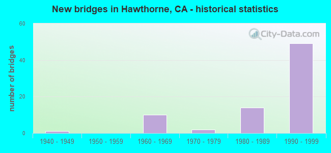
- New bridges - historical statistics
- 11940-1949
- 101960-1969
- 21970-1979
- 141980-1989
- 491990-1999

- Reconstructed bridges - Historical Statistics
- 31980-1989
- 11990-1999


- Bridge Condition - Deck
- 84.6%Good
- 11.5%Satisfactory
- 3.8%Fair

- Bridge Condition - Superstructure
- 96.0%Good
- 4.0%Satisfactory

- Bridge Condition - Substructure
- 96.2%Good
- 3.8%Satisfactory

- Bridge Condition - Channel
- 80.0%Excellent
- 20.0%Very good

- Bridge Condition - Culverts
- 25.0%Very good
- 75.0%Good
Find on map >> Show street view
Structure Number: 53 123, Location: 07-LA-405-17.14-LNDL (Lat: 33.879933, Lng: -118.346931), Route carried "on" structure: Interstate 405, Year Built: 1962, Year Reconstructed: 2003, Status: Open, Structure Length: 5.33m (17.49ft), Average Daily Traffic: 268,300 (year 2019), Truck Traffic: 5%, Average Future Daily Traffic: 304,690 (year 2038), Design Load: HS 20, Features Intersected: 166TH STREET
Minimum Vertical Clearance: 30+ m (98+ ft), Kilometerpoint: 17.140, Lanes on structure: 10, Lanes under structure: 2, Base Highway Network: Yes (Inventory Route: 4, Subroute: 1), Owner: State Highway Agency, Approaching Roadway Width: 41.1m (134.8ft), Skew: 39 degrees, Material/Design: Concrete continuous, Design/Construction: Box Beam or Girders - Multiple, Number Of Spans In Main Unit: 3, Length of Maximum Span: 29.3m (96.1ft), Curb or Sidewalk Widths: Left: 0.0m, Right: 0.6m (2.0ft), Curb-To-Curb Width: 41.1m (134.8ft), Out-to-Out Width: 43.1m (141.4ft)
Condition: Deck: Good, Superstructure: Good, Substructure: Good, Operating Rating: 99.8 metric tons, Method Used To Determine Operating Rating: Load Factor (LF), Inventory Rating: 58.0 metric tons, Method Used To Determine Inventory Rating: Load Factor (LF), Structural Evaluation: Better than present minimum criteria, Deck Geometry: Meets minimum limits, Underclear: Better than present minimum criteria, Approach Roadway Alignment: Superior to present desirable criteria, Designated Inspection Frequency: Every 24 months, Inspection Date: November 2020, Deck Structure Type: Concrete Cast-file-Place, Wearing Surface/Protective System: Wearing Surface: Monolithic Concrete
Find on map >> Show street view
Structure Number: 53 1235, Location: 07-LA-405-18.92-HAW (Lat: 33.897467, Lng: -118.369469), Route carried "on" structure: Interstate 405, Year Built: 1963, Status: Open, Structure Length: 0.82m (2.69ft), Average Daily Traffic: 255,000 (year 2012), Truck Traffic: 5%, Average Future Daily Traffic: 304,690 (year 2037), Design Load: HS 20+Mod, Features Intersected: BNSF RY SPUR
Minimum Vertical Clearance: 30+ m (98+ ft), Kilometerpoint: 18.920, Lanes on structure: 11, Lanes under structure: 11, Base Highway Network: Yes (Inventory Route: 4, Subroute: 1), Owner: State Highway Agency, Approaching Roadway Width: 42.0m (137.8ft), Skew: 32 degrees, Material/Design: Concrete, Design/Construction: Slab, Number Of Spans In Main Unit: 1, Length of Maximum Span: 7.3m (24.0ft), Curb-To-Curb Width: 40.0m (131.2ft), Out-to-Out Width: 60.3m (197.8ft)
Condition: Deck: Good, Superstructure: Good, Substructure: Good, Operating Rating: 62.5 metric tons, Method Used To Determine Operating Rating: Load Factor (LF), Inventory Rating: 37.6 metric tons, Method Used To Determine Inventory Rating: Load Factor (LF), Structural Evaluation: Better than present minimum criteria, Deck Geometry: High priority of replacement, Underclear: Meets minimum limits, Approach Roadway Alignment: Superior to present desirable criteria, Designated Inspection Frequency: Every 24 months, Inspection Date: November 2020
Find on map >> Show street view
Structure Number: 53 1236, Location: 07-LA-405-19.21-HAW (Lat: 33.901583, Lng: -118.370214), Route carried "on" structure: Interstate 405, Year Built: 1963, Status: Open, Structure Length: 5.73m (18.80ft), Average Daily Traffic: 260,800 (year 2019), Truck Traffic: 5%, Average Future Daily Traffic: 304,690 (year 2038), Design Load: HS 20, Features Intersected: ROSECRANS AVE
Minimum Vertical Clearance: 30+ m (98+ ft), Kilometerpoint: 19.210, Lanes on structure: 11, Lanes under structure: 6, Base Highway Network: Yes (Inventory Route: 4, Subroute: 1), Owner: State Highway Agency, Approaching Roadway Width: 41.5m (136.2ft), Skew: 30 degrees, Material/Design: Concrete continuous, Design/Construction: Box Beam or Girders - Multiple, Number Of Spans In Main Unit: 4, Length of Maximum Span: 21.3m (69.9ft), Curb or Sidewalk Widths: Left: 0.6m (2.0ft), Right: 0.6m (2.0ft), Curb-To-Curb Width: 41.5m (136.2ft), Out-to-Out Width: 43.9m (144.0ft)
Condition: Deck: Good, Superstructure: Good, Substructure: Good, Operating Rating: 75.8 metric tons, Method Used To Determine Operating Rating: Load Factor (LF), Inventory Rating: 45.4 metric tons, Method Used To Determine Inventory Rating: Load Factor (LF), Structural Evaluation: Better than present minimum criteria, Deck Geometry: Meets minimum limits, Underclear: Equal to present minimum criteria, Approach Roadway Alignment: Superior to present desirable criteria, Designated Inspection Frequency: Every 24 months, Inspection Date: November 2020, Deck Structure Type: Concrete Cast-file-Place
Find on map >> Show street view
Structure Number: 53 1237, Location: 07-LA-405-19.74-HAW (Lat: 33.909289, Lng: -118.370194), Route carried "on" structure: Interstate 405, Year Built: 1963, Year Reconstructed: 1985, Status: Open, Structure Length: 4.21m (13.81ft), Average Daily Traffic: 260,800 (year 2019), Truck Traffic: 5%, Average Future Daily Traffic: 304,690 (year 2038), Design Load: HS 20, Features Intersected: 135TH STREET
Minimum Vertical Clearance: 30+ m (98+ ft), Kilometerpoint: 19.740, Lanes on structure: 12, Lanes under structure: 4, Base Highway Network: Yes (Inventory Route: 4, Subroute: 1), Owner: State Highway Agency, Approaching Roadway Width: 49.7m (163.1ft), Skew: 30 degrees, Material/Design: Concrete continuous, Design/Construction: Box Beam or Girders - Multiple, Number Of Spans In Main Unit: 3, Length of Maximum Span: 25.0m (82.0ft), Curb-To-Curb Width: 47.9m (157.2ft), Out-to-Out Width: 49.4m (162.1ft)
Condition: Deck: Good, Superstructure: Good, Substructure: Good, Operating Rating: 66.2 metric tons, Method Used To Determine Operating Rating: Load Factor (LF), Inventory Rating: 39.0 metric tons, Method Used To Determine Inventory Rating: Load Factor (LF), Structural Evaluation: Better than present minimum criteria, Deck Geometry: Meets minimum limits, Underclear: Equal to present minimum criteria, Approach Roadway Alignment: Superior to present desirable criteria, Designated Inspection Frequency: Every 24 months, Inspection Date: November 2020, Deck Structure Type: Concrete Cast-file-Place
Find on map >> Show street view
Structure Number: 53 1238, Location: 07-LA-405-20.18-HAW (Lat: 33.915733, Lng: -118.370144), Route carried "on" structure: Interstate 405, Year Built: 1963, Year Reconstructed: 1989, Status: Open, Structure Length: 1.83m (6.00ft), Average Daily Traffic: 260,800 (year 2019), Truck Traffic: 5%, Average Future Daily Traffic: 299,221 (year 2038), Design Load: HS 20, Features Intersected: UP RR
Minimum Vertical Clearance: 30+ m (98+ ft), Kilometerpoint: 20.180, Lanes on structure: 10, Base Highway Network: Yes (Inventory Route: 4, Subroute: 1), Owner: State Highway Agency, Approaching Roadway Width: 59.7m (195.9ft), Skew: 33 degrees, Material/Design: Concrete, Design/Construction: Slab, Number Of Spans In Main Unit: 1, Length of Maximum Span: 9.4m (30.8ft), Curb-To-Curb Width: 59.7m (195.9ft), Out-to-Out Width: 66.8m (219.2ft)
Condition: Deck: Good, Superstructure: Good, Substructure: Good, Operating Rating: 54.1 metric tons, Method Used To Determine Operating Rating: Assigned rating based on Load Factor Design (LFD) reported in metric tons, Inventory Rating: 32.4 metric tons, Method Used To Determine Inventory Rating: Assigned rating based on Load Factor Design (LFD) reported in metric tons, Structural Evaluation: Better than present minimum criteria, Deck Geometry: Superior to present desirable criteria, Underclear: Somewhat better than minimum adequacy, Approach Roadway Alignment: Equal to present desirable criteria, Designated Inspection Frequency: Every 24 months, Inspection Date: November 2020, Deck Structure Type: Concrete Cast-file-Place, Wearing Surface/Protective System: Wearing Surface: Other
Find on map >> Show street view
Structure Number: 53 1238G, Location: 07-LA-405-20.19-HAW (Lat: 33.915817, Lng: -118.369981), Route carried "on" structure: Ramp Interstate 405, Year Built: 1989, Status: Open, Structure Length: 47.79m (156.79ft), Average Daily Traffic: 10,000 (year 2019), Truck Traffic: 2%, Average Future Daily Traffic: 30,484 (year 2038), Design Load: HS 20+Mod, Features Intersected: UPRR, EL SEGUNDO BL,RMPS
Minimum Vertical Clearance: 30+ m (98+ ft), Kilometerpoint: 20.190, Lanes on structure: 2, Lanes under structure: 9, Owner: State Highway Agency, Approaching Roadway Width: 12.2m (40.0ft), Material/Design: Prestressed concrete continuous, Design/Construction: Box Beam or Girders - Multiple, Number Of Spans In Main Unit: 11, Length of Maximum Span: 54.9m (180.1ft), Curb-To-Curb Width: 11.7m (38.4ft), Out-to-Out Width: 12.8m (42.0ft)
Condition: Deck: Good, Superstructure: Good, Substructure: Good, Operating Rating: 54.1 metric tons, Method Used To Determine Operating Rating: Assigned rating based on Load Factor Design (LFD) reported in metric tons, Inventory Rating: 32.4 metric tons, Method Used To Determine Inventory Rating: Assigned rating based on Load Factor Design (LFD) reported in metric tons, Structural Evaluation: Better than present minimum criteria, Deck Geometry: Superior to present desirable criteria, Underclear: Equal to present minimum criteria, Approach Roadway Alignment: Equal to present desirable criteria, Designated Inspection Frequency: Every 24 months, Inspection Date: November 2020, Deck Structure Type: Concrete Cast-file-Place
Find on map >> Show street view
Structure Number: 53 1239, Location: 07-LA-405-20.22-HAW (Lat: 33.916256, Lng: -118.370036), Route carried "on" structure: Interstate 405, Year Built: 1963, Year Reconstructed: 1989, Status: Open, Structure Length: 3.17m (10.40ft), Average Daily Traffic: 260,800 (year 2012), Truck Traffic: 5%, Average Future Daily Traffic: 304,690 (year 2037), Design Load: HS 20, Features Intersected: EL SEGUNDO BLVD
Minimum Vertical Clearance: 30+ m (98+ ft), Kilometerpoint: 20.220, Lanes on structure: 8, Lanes under structure: 6, Base Highway Network: Yes (Inventory Route: 4, Subroute: 1), Owner: State Highway Agency, Approaching Roadway Width: 43.6m (143.0ft), Skew: 30 degrees, Material/Design: Concrete, Design/Construction: Box Beam or Girders - Multiple, Number Of Spans In Main Unit: 1, Length of Maximum Span: 31.4m (103.0ft), Curb-To-Curb Width: 43.6m (143.0ft), Out-to-Out Width: 46.6m (152.9ft)
Condition: Deck: Good, Superstructure: Good, Substructure: Good, Operating Rating: 87.5 metric tons, Method Used To Determine Operating Rating: Load Factor (LF), Inventory Rating: 52.8 metric tons, Method Used To Determine Inventory Rating: Load Factor (LF), Structural Evaluation: Better than present minimum criteria, Deck Geometry: Superior to present desirable criteria, Underclear: Meets minimum limits, Approach Roadway Alignment: Equal to present desirable criteria, Designated Inspection Frequency: Every 24 months, Inspection Date: December 2020, Deck Structure Type: Concrete Cast-file-Place
Find on map >> Show street view
Structure Number: 53 1239J, Location: 07-LA-405-20.24-HAW (Lat: 33.916183, Lng: -118.370992), Route carried "on" structure: Ramp Interstate 405, Year Built: 1989, Status: Open, Structure Length: 5.00m (16.40ft), Average Daily Traffic: 2,000 (year 2012), Truck Traffic: 2%, Average Future Daily Traffic: 3,995 (year 2037), Design Load: HS 20+Mod, Features Intersected: EL SEGUNDO BLVD, Facility Carried by Structure: 105-EL SEGUNDO BL
Minimum Vertical Clearance: 30+ m (98+ ft), Kilometerpoint: 20.240, Lanes on structure: 2, Lanes under structure: 6, Owner: State Highway Agency, Approaching Roadway Width: 9.8m (32.2ft), Skew: 9 degrees, Material/Design: Prestressed concrete, Design/Construction: Box Beam or Girders - Multiple, Number Of Spans In Main Unit: 1, Length of Maximum Span: 49.1m (161.1ft), Curb-To-Curb Width: 9.8m (32.2ft), Out-to-Out Width: 10.8m (35.4ft)
Condition: Deck: Good, Superstructure: Good, Substructure: Good, Operating Rating: 54.1 metric tons, Method Used To Determine Operating Rating: Assigned rating based on Load Factor Design (LFD) reported in metric tons, Inventory Rating: 32.4 metric tons, Method Used To Determine Inventory Rating: Assigned rating based on Load Factor Design (LFD) reported in metric tons, Structural Evaluation: Better than present minimum criteria, Deck Geometry: Equal to present minimum criteria, Underclear: Meets minimum limits, Approach Roadway Alignment: Equal to present desirable criteria, Designated Inspection Frequency: Every 24 months, Inspection Date: December 2020, Deck Structure Type: Concrete Cast-file-Place
Find on map >> Show street view
Structure Number: 53 1241T, Location: 07-LA-405-R21.22-HAW (Lat: 33.930672, Lng: -118.367828), Route carried "on" structure: Bypass Interstate 405, Year Built: 1994, Status: Open, Structure Length: 4.82m (15.81ft), Average Daily Traffic: 2,000 (year 2019), Truck Traffic: 1%, Average Future Daily Traffic: 2,312 (year 2038), Design Load: HS 20+Mod, Features Intersected: IMPERIAL HIGHWAY
Minimum Vertical Clearance: 30+ m (98+ ft), Kilometerpoint: 21.220, Lanes on structure: 2, Lanes under structure: 6, Base Highway Network: Yes (Inventory Route: 4, Subroute: 1), Owner: State Highway Agency, Approaching Roadway Width: 9.8m (32.2ft), Material/Design: Prestressed concrete, Design/Construction: Box Beam or Girders - Multiple, Number Of Spans In Main Unit: 1, Number Of Approach Spans: 2, Length of Maximum Span: 31.1m (102.0ft), Curb-To-Curb Width: 9.7m (31.8ft), Out-to-Out Width: 10.8m (35.4ft)
Condition: Deck: Good, Superstructure: Good, Substructure: Good, Operating Rating: 54.1 metric tons, Method Used To Determine Operating Rating: Assigned rating based on Load Factor Design (LFD) reported in metric tons, Inventory Rating: 32.4 metric tons, Method Used To Determine Inventory Rating: Assigned rating based on Load Factor Design (LFD) reported in metric tons, Structural Evaluation: Better than present minimum criteria, Deck Geometry: High priority of replacement, Underclear: Meets minimum limits, Approach Roadway Alignment: Better than present minimum criteria, Designated Inspection Frequency: Every 24 months, Inspection Date: December 2020, Deck Structure Type: Concrete Cast-file-Place
Find on map >> Show street view
Structure Number: 53 2381L, Location: 07-LA-014-R66.73-LAN (Lat: 34.674739, Lng: -118.157633), Route carried "on" structure: State highway 14, Year Built: 1972, Status: Open, Structure Length: 5.70m (18.70ft), Average Daily Traffic: 38,000 (year 2017), Truck Traffic: 5%, Average Future Daily Traffic: 42,766 (year 2041), Design Load: HS 20, Features Intersected: AVENUE "K"
Minimum Vertical Clearance: 30+ m (98+ ft), Kilometerpoint: 66.730, Lanes on structure: 4, Lanes under structure: 6, Base Highway Network: Yes (, Subroute: 1), Owner: State Highway Agency, Approaching Roadway Width: 19.2m (63.0ft), Skew: 3 degrees, Material/Design: Concrete continuous, Design/Construction: Box Beam or Girders - Multiple, Number Of Spans In Main Unit: 2, Length of Maximum Span: 28.3m (92.8ft), Curb-To-Curb Width: 18.5m (60.7ft), Out-to-Out Width: 19.2m (63.0ft)
Condition: Deck: Good, Superstructure: Good, Substructure: Good, Operating Rating: 76.8 metric tons, Method Used To Determine Operating Rating: Load and Resistance Factor Rating (LRFR) rating reported by rating factor(RF) method using HL-93 loadings, Inventory Rating: 59.3 metric tons, Method Used To Determine Inventory Rating: Load and Resistance Factor Rating (LRFR) rating reported by rating factor(RF) method using HL-93 loadings, Structural Evaluation: Better than present minimum criteria, Deck Geometry: Meets minimum limits, Underclear: Meets minimum limits, Approach Roadway Alignment: Equal to present desirable criteria, Designated Inspection Frequency: Every 24 months, Inspection Date: April 2021, Deck Structure Type: Concrete Cast-file-Place
Find on map >> Show street view
Structure Number: 53 2387K, Location: 07-LA-405-20.16-HAW (Lat: 33.915200, Lng: -118.370947), Route carried "on" structure: Ramp Interstate 405, Year Built: 1989, Status: Open, Structure Length: 3.57m (11.71ft), Average Daily Traffic: 20,640 (year 2012), Truck Traffic: 2%, Average Future Daily Traffic: 25,144 (year 2037), Design Load: HS 20+Mod, Features Intersected: UP RR
Minimum Vertical Clearance: 30+ m (98+ ft), Kilometerpoint: 20.160, Lanes on structure: 1, Owner: State Highway Agency, Approaching Roadway Width: 8.2m (26.9ft), Material/Design: Prestressed concrete, Design/Construction: Box Beam or Girders - Multiple, Number Of Spans In Main Unit: 1, Length of Maximum Span: 34.7m (113.8ft), Curb-To-Curb Width: 8.2m (26.9ft), Out-to-Out Width: 9.2m (30.2ft)
Condition: Deck: Good, Superstructure: Good, Substructure: Good, Operating Rating: 54.1 metric tons, Method Used To Determine Operating Rating: Assigned rating based on Load Factor Design (LFD) reported in metric tons, Inventory Rating: 32.4 metric tons, Method Used To Determine Inventory Rating: Assigned rating based on Load Factor Design (LFD) reported in metric tons, Structural Evaluation: Better than present minimum criteria, Deck Geometry: Superior to present desirable criteria, Underclear: Somewhat better than minimum adequacy, Approach Roadway Alignment: Equal to present minimum criteria, Length Of Structure Improvement: 3.57m (11.71ft), Designated Inspection Frequency: Every 24 months, Inspection Date: November 2020, Deck Structure Type: Concrete Cast-file-Place
Find on map >> Show street view
Structure Number: 53 2388S, Location: 07-LA-405-20.17-HAW (Lat: 33.915636, Lng: -118.369786), Route carried "on" structure: Ramp Interstate 405, Year Built: 1989, Status: Open, Structure Length: 13.62m (44.69ft), Average Daily Traffic: 10,000 (year 2019), Truck Traffic: 3%, Average Future Daily Traffic: 13,140 (year 2038), Design Load: HS 20+Mod, Features Intersected: UP RR & EL SEGUNDO BL
Minimum Vertical Clearance: 30+ m (98+ ft), Kilometerpoint: 20.170, Lanes on structure: 2, Lanes under structure: 8, Owner: State Highway Agency, Approaching Roadway Width: 9.8m (32.2ft), Material/Design: Prestressed concrete continuous, Design/Construction: Box Beam or Girders - Multiple, Number Of Spans In Main Unit: 4, Length of Maximum Span: 40.2m (131.9ft), Curb-To-Curb Width: 9.8m (32.2ft), Out-to-Out Width: 10.8m (35.4ft)
Condition: Deck: Good, Superstructure: Good, Substructure: Good, Operating Rating: 54.1 metric tons, Method Used To Determine Operating Rating: Assigned rating based on Load Factor Design (LFD) reported in metric tons, Inventory Rating: 32.4 metric tons, Method Used To Determine Inventory Rating: Assigned rating based on Load Factor Design (LFD) reported in metric tons, Structural Evaluation: Better than present minimum criteria, Deck Geometry: Equal to present minimum criteria, Underclear: Equal to present minimum criteria, Approach Roadway Alignment: Equal to present desirable criteria, Designated Inspection Frequency: Every 24 months, Inspection Date: November 2020, Deck Structure Type: Concrete Cast-file-Place
Find on map >> Show street view
Structure Number: 53 24, Location: 07-LA-105-R2.00-HAW (Lat: 33.929686, Lng: -118.370303), Route carried "on" structure: Interstate 105, Year Built: 1991, Status: Open, Structure Length: 72.21m (236.91ft), Average Daily Traffic: 116,225 (year 2011), Truck Traffic: 4%, Average Future Daily Traffic: 278,988 (year 2040), Design Load: HS 20+Mod, Features Intersected: ROUTE 405,CONNS,STREETS
Minimum Vertical Clearance: 6.25m (20.51ft), Kilometerpoint: 2.000, Lanes on structure: 8, Lanes under structure: 42, Base Highway Network: Yes (Inventory Route: 1, Subroute: 1), Owner: State Highway Agency, Approaching Roadway Width: 43.4m (142.4ft), Skew: 39 degrees, Material/Design: Prestressed concrete continuous, Design/Construction: Box Beam or Girders - Multiple, Number Of Spans In Main Unit: 18, Length of Maximum Span: 52.4m (171.9ft), Curb-To-Curb Width: 43.4m (142.4ft), Out-to-Out Width: 58.3m (191.3ft)
Condition: Deck: Good, Superstructure: Good, Substructure: Good, Operating Rating: 54.1 metric tons, Method Used To Determine Operating Rating: Assigned rating based on Load Factor Design (LFD) reported in metric tons, Inventory Rating: 32.4 metric tons, Method Used To Determine Inventory Rating: Assigned rating based on Load Factor Design (LFD) reported in metric tons, Structural Evaluation: Better than present minimum criteria, Deck Geometry: Superior to present desirable criteria, Underclear: Somewhat better than minimum adequacy, Approach Roadway Alignment: Equal to present desirable criteria, Designated Inspection Frequency: Every 24 months, Inspection Date: March 2020, Deck Structure Type: Concrete Cast-file-Place
Find on map >> Show street view
Structure Number: 53 2432, Location: 07-LA-105-R3.05-HAW (Lat: 33.934025, Lng: -118.352914), Route carried "on" structure: City street , Year Built: 1993, Status: Open, Structure Length: 10.94m (35.89ft), Average Daily Traffic: 37,700 (year 2006), Truck Traffic: 1%, Average Future Daily Traffic: 46,387 (year 2037), Design Load: HS 20+Mod, Features Intersected: ROUTE 105 & LRT, Facility Carried by Structure: HAWTHORNE BLVD
Minimum Vertical Clearance: 30+ m (98+ ft), Kilometerpoint: 0.000, Lanes on structure: 7, Lanes under structure: 13, Base Highway Network: Yes, Owner: State Highway Agency, Approaching Roadway Width: 40.2m (131.9ft), Skew: 20 degrees, Material/Design: Prestressed concrete continuous, Design/Construction: Box Beam or Girders - Multiple, Number Of Spans In Main Unit: 2, Length of Maximum Span: 62.8m (206.0ft), Curb or Sidewalk Widths: Left: 3.0m (9.8ft), Right: 3.0m (9.8ft), Curb-To-Curb Width: 40.2m (131.9ft), Out-to-Out Width: 54.3m (178.1ft)
Condition: Deck: Satisfactory, Superstructure: Good, Substructure: Good, Operating Rating: 54.1 metric tons, Method Used To Determine Operating Rating: Assigned rating based on Load Factor Design (LFD) reported in metric tons, Inventory Rating: 32.4 metric tons, Method Used To Determine Inventory Rating: Assigned rating based on Load Factor Design (LFD) reported in metric tons, Structural Evaluation: Better than present minimum criteria, Deck Geometry: Superior to present desirable criteria, Underclear: Somewhat better than minimum adequacy, Approach Roadway Alignment: Equal to present desirable criteria, Designated Inspection Frequency: Every 24 months, Inspection Date: March 2020, Deck Structure Type: Concrete Cast-file-Place
Find on map >> Show street view
Structure Number: 53 2435, Location: 07-LA-105-R2.53-HAW (Lat: 33.931603, Lng: -118.361575), Route carried "on" structure: Interstate 105, Year Built: 1993, Status: Open, Structure Length: 4.54m (14.90ft), Average Daily Traffic: 116,225 (year 2011), Truck Traffic: 4%, Average Future Daily Traffic: 278,988 (year 2040), Design Load: HS 20+Mod, Features Intersected: INGLEWOOD AVE
Minimum Vertical Clearance: 30+ m (98+ ft), Kilometerpoint: 2.530, Lanes on structure: 8, Lanes under structure: 3, Base Highway Network: Yes (Inventory Route: 1, Subroute: 1), Owner: State Highway Agency, Approaching Roadway Width: 43.6m (143.0ft), Skew: 32 degrees, Material/Design: Prestressed concrete, Design/Construction: Box Beam or Girders - Multiple, Number Of Spans In Main Unit: 1, Length of Maximum Span: 45.4m (149.0ft), Curb-To-Curb Width: 43.6m (143.0ft), Out-to-Out Width: 54.3m (178.1ft)
Condition: Deck: Good, Superstructure: Good, Substructure: Good, Operating Rating: 54.1 metric tons, Method Used To Determine Operating Rating: Assigned rating based on Load Factor Design (LFD) reported in metric tons, Inventory Rating: 32.4 metric tons, Method Used To Determine Inventory Rating: Assigned rating based on Load Factor Design (LFD) reported in metric tons, Structural Evaluation: Better than present minimum criteria, Deck Geometry: Superior to present desirable criteria, Underclear: Meets minimum limits, Approach Roadway Alignment: Superior to present desirable criteria, Designated Inspection Frequency: Every 24 months, Inspection Date: March 2020, Deck Structure Type: Concrete Cast-file-Place
Find on map >> Show street view
Structure Number: 53 2435F, Location: 07-LA-105-R2.53-HAW (Lat: 33.932200, Lng: -118.361558), Route carried "on" structure: Ramp Interstate 105, Year Built: 1993, Status: Open, Structure Length: 4.28m (14.04ft), Average Daily Traffic: 25,212 (year 2011), Truck Traffic: 3%, Average Future Daily Traffic: 30,584 (year 2040), Design Load: HS 20+Mod, Features Intersected: INGLEWOOD AVE
Minimum Vertical Clearance: 30+ m (98+ ft), Kilometerpoint: 2.530, Lanes on structure: 3, Lanes under structure: 3, Base Highway Network: Yes, Owner: State Highway Agency, Approaching Roadway Width: 15.5m (50.9ft), Skew: 1 degrees, Material/Design: Prestressed concrete, Design/Construction: Box Beam or Girders - Multiple, Number Of Spans In Main Unit: 1, Length of Maximum Span: 42.8m (140.4ft), Curb-To-Curb Width: 15.5m (50.9ft), Out-to-Out Width: 16.5m (54.1ft)
Condition: Deck: Good, Superstructure: Good, Substructure: Good, Operating Rating: 54.1 metric tons, Method Used To Determine Operating Rating: Assigned rating based on Load Factor Design (LFD) reported in metric tons, Inventory Rating: 32.4 metric tons, Method Used To Determine Inventory Rating: Assigned rating based on Load Factor Design (LFD) reported in metric tons, Structural Evaluation: Better than present minimum criteria, Deck Geometry: Superior to present desirable criteria, Underclear: Meets minimum limits, Approach Roadway Alignment: Superior to present desirable criteria, Designated Inspection Frequency: Every 24 months, Inspection Date: March 2020, Deck Structure Type: Concrete Cast-file-Place
Find on map >> Show street view
Structure Number: 53 2442G, Location: 07-LA-405-R21.01-LA (Lat: 33.927850, Lng: -118.367467), Route carried "on" structure: Ramp Interstate 405, Year Built: 1991, Status: Open, Structure Length: 52.00m (170.60ft), Average Daily Traffic: 17,000 (year 2012), Truck Traffic: 1%, Average Future Daily Traffic: 18,921 (year 2037), Design Load: HS 20+Mod, Features Intersected: I 405,I 105, CONN
Minimum Vertical Clearance: 30+ m (98+ ft), Kilometerpoint: 21.010, Lanes on structure: 2, Lanes under structure: 20, Base Highway Network: Yes, Owner: State Highway Agency, Approaching Roadway Width: 10.4m (34.1ft), Material/Design: Prestressed concrete continuous, Design/Construction: Box Beam or Girders - Multiple, Number Of Spans In Main Unit: 11, Length of Maximum Span: 59.4m (194.9ft), Curb-To-Curb Width: 10.5m (34.4ft), Out-to-Out Width: 11.6m (38.1ft)
Condition: Deck: Good, Superstructure: Good, Substructure: Good, Operating Rating: 54.1 metric tons, Method Used To Determine Operating Rating: Assigned rating based on Load Factor Design (LFD) reported in metric tons, Inventory Rating: 32.4 metric tons, Method Used To Determine Inventory Rating: Assigned rating based on Load Factor Design (LFD) reported in metric tons, Structural Evaluation: Better than present minimum criteria, Deck Geometry: Better than present minimum criteria, Underclear: High priority of corrective action, Approach Roadway Alignment: Superior to present desirable criteria, Designated Inspection Frequency: Every 24 months, Inspection Date: December 2020, Deck Structure Type: Concrete Cast-file-Place
Find on map >> Show street view
Structure Number: 53 2443F, Location: 07-LA-405-R21.51-HAW (Lat: 33.931667, Lng: -118.361114), Route carried "on" structure: Ramp Interstate 405, Year Built: 1991, Status: Open, Structure Length: 127.96m (419.82ft), Average Daily Traffic: 26,000 (year 2019), Truck Traffic: 2%, Average Future Daily Traffic: 29,335 (year 2038), Design Load: HS 20+Mod, Features Intersected: I 405 & I 105, CONNS
Minimum Vertical Clearance: 30+ m (98+ ft), Kilometerpoint: 21.510, Lanes on structure: 2, Lanes under structure: 33, Base Highway Network: Yes (Inventory Route: 4, Subroute: 1), Owner: State Highway Agency, Approaching Roadway Width: 15.2m (49.9ft), Skew: 9 degrees, Material/Design: Prestressed concrete continuous, Design/Construction: Box Beam or Girders - Multiple, Number Of Spans In Main Unit: 27, Length of Maximum Span: 53.3m (174.9ft), Curb-To-Curb Width: 12.0m (39.4ft), Out-to-Out Width: 12.8m (42.0ft)
Condition: Deck: Fair, Superstructure: Good, Substructure: Good, Operating Rating: 54.1 metric tons, Method Used To Determine Operating Rating: Assigned rating based on Load Factor Design (LFD) reported in metric tons, Inventory Rating: 32.4 metric tons, Method Used To Determine Inventory Rating: Assigned rating based on Load Factor Design (LFD) reported in metric tons, Structural Evaluation: Better than present minimum criteria, Deck Geometry: Superior to present desirable criteria, Underclear: Meets minimum limits, Approach Roadway Alignment: Equal to present desirable criteria, Designated Inspection Frequency: Every 24 months, Inspection Date: December 2020, Deck Structure Type: Concrete Cast-file-Place, Wearing Surface/Protective System: Wearing Surface: Monolithic Concrete
Find on map >> Show street view
Structure Number: 53 2517, Location: 07-LA-105-R3.62-HAW (Lat: 33.930769, Lng: -118.344056), Route carried "on" structure: City street L665, Year Built: 1993, Status: Open, Structure Length: 14.32m (46.98ft), Average Daily Traffic: 35,000 (year 2006), Truck Traffic: 1%, Average Future Daily Traffic: 45,425 (year 2037), Design Load: HS 20+Mod, Features Intersected: ROUTE 105 & LRT, Facility Carried by Structure: PRAIRIE AVE
Minimum Vertical Clearance: 30+ m (98+ ft), Kilometerpoint: 0.000, Lanes on structure: 6, Lanes under structure: 12, Owner: State Highway Agency, Approaching Roadway Width: 25.6m (84.0ft), Skew: 24 degrees, Material/Design: Prestressed concrete continuous, Design/Construction: Box Beam or Girders - Multiple, Number Of Spans In Main Unit: 4, Length of Maximum Span: 38.2m (125.3ft), Curb or Sidewalk Widths: Left: 1.5m (4.9ft), Right: 2.1m (6.9ft), Curb-To-Curb Width: 25.6m (84.0ft), Out-to-Out Width: 29.9m (98.1ft)
Condition: Deck: Satisfactory, Superstructure: Satisfactory, Substructure: Satisfactory, Operating Rating: 54.1 metric tons, Method Used To Determine Operating Rating: Assigned rating based on Load Factor Design (LFD) reported in metric tons, Inventory Rating: 32.4 metric tons, Method Used To Determine Inventory Rating: Assigned rating based on Load Factor Design (LFD) reported in metric tons, Structural Evaluation: Equal to present minimum criteria, Deck Geometry: Somewhat better than minimum adequacy, Underclear: Meets minimum limits, Approach Roadway Alignment: Equal to present desirable criteria, Designated Inspection Frequency: Every 24 months, Inspection Date: March 2020, Deck Structure Type: Concrete Cast-file-Place
Find on map >> Show street view
Structure Number: 53 2522, Location: 07-LA-105-R5.48-HAW (Lat: 33.925875, Lng: -118.313517), Route carried "on" structure: County highway , Year Built: 1988, Status: Open, Structure Length: 9.91m (32.51ft), Average Daily Traffic: 6,300 (year 2006), Truck Traffic: 1%, Average Future Daily Traffic: 7,267 (year 2042), Design Load: HS 20+Mod, Features Intersected: ROUTE 105 & LRT, Facility Carried by Structure: WILTON PLACE
Minimum Vertical Clearance: 30+ m (98+ ft), Kilometerpoint: 0.000, Lanes on structure: 2, Lanes under structure: 10, Owner: State Highway Agency, Approaching Roadway Width: 12.2m (40.0ft), Material/Design: Prestressed concrete continuous, Design/Construction: Box Beam or Girders - Multiple, Number Of Spans In Main Unit: 2, Length of Maximum Span: 50.9m (167.0ft), Curb or Sidewalk Widths: Left: 1.5m (4.9ft), Right: 1.5m (4.9ft), Curb-To-Curb Width: 12.2m (40.0ft), Out-to-Out Width: 15.8m (51.8ft)
Condition: Deck: Good, Superstructure: Good, Substructure: Good, Operating Rating: 54.1 metric tons, Method Used To Determine Operating Rating: Assigned rating based on Load Factor Design (LFD) reported in metric tons, Inventory Rating: 32.4 metric tons, Method Used To Determine Inventory Rating: Assigned rating based on Load Factor Design (LFD) reported in metric tons, Structural Evaluation: Better than present minimum criteria, Deck Geometry: Somewhat better than minimum adequacy, Underclear: Meets minimum limits, Approach Roadway Alignment: Superior to present desirable criteria, Designated Inspection Frequency: Every 24 months, Inspection Date: April 2020, Deck Structure Type: Concrete Cast-file-Place, Wearing Surface/Protective System: Wearing Surface: Monolithic Concrete
Find on map >> Show street view
Structure Number: 53 2653K, Location: 07-LA-105-R3.50-HAW (Lat: 33.931875, Lng: -118.346367), Route carried "on" structure: Ramp Interstate 105, Year Built: 1993, Status: Open, Structure Length: 14.84m (48.69ft), Average Daily Traffic: 6,500 (year 2006), Truck Traffic: 2%, Average Future Daily Traffic: 7,695 (year 2037), Design Load: HS 20+Mod, Features Intersected: ROUTE 105 & LRT
Minimum Vertical Clearance: 30+ m (98+ ft), Kilometerpoint: 3.500, Lanes on structure: 2, Base Highway Network: Yes (Inventory Route: 1, Subroute: 1), Owner: State Highway Agency, Approaching Roadway Width: 9.8m (32.2ft), Skew: 9 degrees, Material/Design: Concrete continuous, Design/Construction: Box Beam or Girders - Multiple, Number Of Spans In Main Unit: 4, Number Of Approach Spans: 4, Length of Maximum Span: 31.7m (104.0ft), Curb-To-Curb Width: 9.8m (32.2ft), Out-to-Out Width: 10.8m (35.4ft)
Condition: Deck: Good, Superstructure: Good, Substructure: Good, Operating Rating: 54.1 metric tons, Method Used To Determine Operating Rating: Assigned rating based on Load Factor Design (LFD) reported in metric tons, Inventory Rating: 32.4 metric tons, Method Used To Determine Inventory Rating: Assigned rating based on Load Factor Design (LFD) reported in metric tons, Structural Evaluation: Better than present minimum criteria, Deck Geometry: Equal to present minimum criteria, Approach Roadway Alignment: Equal to present desirable criteria, Designated Inspection Frequency: Every 24 months, Inspection Date: March 2020, Deck Structure Type: Concrete Cast-file-Place
Find on map >> Show street view
Structure Number: 53 2655, Location: 07-LA-105-R3.51-HAW (Lat: 33.931100, Lng: -118.344442), Route carried "on" structure: City street , Year Built: 1993, Status: Open, Structure Length: 19.40m (63.65ft), Average Daily Traffic: 32,900 (year 2014), Truck Traffic: 1%, Average Future Daily Traffic: 48,410 (year 2041), Design Load: HS 20+Mod, Features Intersected: ROUTE 105 & LRT, Facility Carried by Structure: IMPERIAL HIGHWAY
Minimum Vertical Clearance: 30+ m (98+ ft), Kilometerpoint: 0.000, Lanes on structure: 7, Lanes under structure: 13, Base Highway Network: Yes, Owner: State Highway Agency, Approaching Roadway Width: 27.5m (90.2ft), Skew: 5 degrees, Material/Design: Prestressed concrete continuous, Design/Construction: Box Beam or Girders - Multiple, Number Of Spans In Main Unit: 4, Length of Maximum Span: 50.2m (164.7ft), Curb or Sidewalk Widths: Left: 1.5m (4.9ft), Right: 2.1m (6.9ft), Curb-To-Curb Width: 27.5m (90.2ft), Out-to-Out Width: 31.7m (104.0ft)
Condition: Deck: Good, Superstructure: Good, Substructure: Good, Operating Rating: 54.1 metric tons, Method Used To Determine Operating Rating: Assigned rating based on Load Factor Design (LFD) reported in metric tons, Inventory Rating: 32.4 metric tons, Method Used To Determine Inventory Rating: Assigned rating based on Load Factor Design (LFD) reported in metric tons, Structural Evaluation: Better than present minimum criteria, Deck Geometry: Somewhat better than minimum adequacy, Underclear: Meets minimum limits, Approach Roadway Alignment: Superior to present desirable criteria, Designated Inspection Frequency: Every 24 months, Inspection Date: March 2020, Deck Structure Type: Concrete Cast-file-Place, Wearing Surface/Protective System: Wearing Surface: Monolithic Concrete
Find on map >> Show street view
Structure Number: 53 2656S, Location: 07-LA-105-R3.32-HAW (Lat: 33.932278, Lng: -118.349278), Route carried "on" structure: Ramp Interstate 105, Year Built: 1993, Status: Open, Structure Length: 19.01m (62.37ft), Average Daily Traffic: 8,400 (year 2014), Truck Traffic: 2%, Average Future Daily Traffic: 9,619 (year 2041), Design Load: HS 20+Mod, Features Intersected: ROUTE 105 & LRT, Facility Carried by Structure: EB PRAIRIE OFF RA
Minimum Vertical Clearance: 30+ m (98+ ft), Kilometerpoint: 3.320, Lanes on structure: 2, Lanes under structure: 11, Base Highway Network: Yes (Inventory Route: 1, Subroute: 1), Owner: State Highway Agency, Approaching Roadway Width: 9.8m (32.2ft), Skew: 9 degrees, Material/Design: Prestressed concrete continuous, Design/Construction: Box Beam or Girders - Multiple, Number Of Spans In Main Unit: 4, Length of Maximum Span: 59.3m (194.6ft), Curb-To-Curb Width: 9.8m (32.2ft), Out-to-Out Width: 10.8m (35.4ft)
Condition: Deck: Good, Superstructure: Good, Substructure: Good, Operating Rating: 54.1 metric tons, Method Used To Determine Operating Rating: Assigned rating based on Load Factor Design (LFD) reported in metric tons, Inventory Rating: 32.4 metric tons, Method Used To Determine Inventory Rating: Assigned rating based on Load Factor Design (LFD) reported in metric tons, Structural Evaluation: Better than present minimum criteria, Deck Geometry: Equal to present minimum criteria, Underclear: Meets minimum limits, Approach Roadway Alignment: Meets minimum limits, Designated Inspection Frequency: Every 24 months, Inspection Date: March 2020, Deck Structure Type: Concrete Cast-file-Place, Wearing Surface/Protective System: Wearing Surface: Monolithic Concrete
Find on map >> Show street view
Structure Number: 53 2686H, Location: 07-LA-105-R2.03-HAW (Lat: 33.920194, Lng: -118.370069), Route carried "on" structure: Ramp Interstate 105, Year Built: 1989, Status: Open, Structure Length: 13.18m (43.24ft), Average Daily Traffic: 30,879 (year 2011), Truck Traffic: 2%, Average Future Daily Traffic: 35,974 (year 2040), Design Load: HS 20+Mod, Features Intersected: S405 ON AND OFF RAMPS
Minimum Vertical Clearance: 30+ m (98+ ft), Kilometerpoint: 2.030, Lanes on structure: 2, Lanes under structure: 4, Base Highway Network: Yes (Inventory Route: 1, Subroute: 1), Owner: State Highway Agency, Approaching Roadway Width: 11.8m (38.7ft), Material/Design: Prestressed concrete continuous, Design/Construction: Box Beam or Girders - Multiple, Number Of Spans In Main Unit: 4, Length of Maximum Span: 38.1m (125.0ft), Curb-To-Curb Width: 11.8m (38.7ft), Out-to-Out Width: 12.8m (42.0ft)
Condition: Deck: Good, Superstructure: Good, Substructure: Good, Operating Rating: 54.1 metric tons, Method Used To Determine Operating Rating: Assigned rating based on Load Factor Design (LFD) reported in metric tons, Inventory Rating: 32.4 metric tons, Method Used To Determine Inventory Rating: Assigned rating based on Load Factor Design (LFD) reported in metric tons, Structural Evaluation: Better than present minimum criteria, Deck Geometry: Superior to present desirable criteria, Underclear: Meets minimum limits, Approach Roadway Alignment: Equal to present desirable criteria, Designated Inspection Frequency: Every 24 months, Inspection Date: March 2020, Deck Structure Type: Concrete Cast-file-Place
Find on map >> Show street view
Structure Number: 53 2733, Location: 07-LA-110-9.80-LA (Lat: 33.871253, Lng: -118.289033), Route carried "on" structure: Interstate 110, Year Built: 1995, Status: Open, Structure Length: 120.00m (393.70ft), Average Daily Traffic: 18,200 (year 2020), Truck Traffic: 6%, Average Future Daily Traffic: 22,450 (year 2037), Design Load: HS 20+Mod, Features Intersected: I 110,SR 91 & CONNECTORS
Minimum Vertical Clearance: 30+ m (98+ ft), Kilometerpoint: 9.800, Lanes on structure: 4, Lanes under structure: 27, Base Highway Network: Yes (Inventory Route: 1, Subroute: 1), Owner: State Highway Agency, Approaching Roadway Width: 19.5m (64.0ft), Skew: 30 degrees, Material/Design: Prestressed concrete continuous, Design/Construction: Box Beam or Girders - Multiple, Number Of Spans In Main Unit: 30, Number Of Approach Spans: 6, Length of Maximum Span: 46.9m (153.9ft), Curb-To-Curb Width: 18.9m (62.0ft), Out-to-Out Width: 20.6m (67.6ft)
Condition: Deck: Good, Substructure: Good, Operating Rating: 54.1 metric tons, Method Used To Determine Operating Rating: Assigned rating based on Load Factor Design (LFD) reported in metric tons, Inventory Rating: 32.4 metric tons, Method Used To Determine Inventory Rating: Assigned rating based on Load Factor Design (LFD) reported in metric tons, Structural Evaluation: Better than present minimum criteria, Deck Geometry: Meets minimum limits, Underclear: High priority of corrective action, Approach Roadway Alignment: Equal to present desirable criteria, Designated Inspection Frequency: Every 24 months, Inspection Date: March 2020, Deck Structure Type: Concrete Cast-file-Place, Wearing Surface/Protective System: Wearing Surface: Monolithic Concrete
Find on map >> Show street view
Structure Number: 53C0342, Location: AT 116TH ST (Lat: 33.929042, Lng: -118.352381), Route carried "on" structure: City street L026, Year Built: 1949, Status: Open, Structure Length: 1.07m (3.51ft), Average Daily Traffic: 43,918 (year 2012), Truck Traffic: 4%, Average Future Daily Traffic: 52,702 (year 2041), Features Intersected: 116TH ST STORM DRN, Facility Carried by Structure: HAWTHORNE BLVD
Minimum Vertical Clearance: 30+ m (98+ ft), Kilometerpoint: 0.000, Lanes on structure: 8, Owner: City or Municipal Highway Agency, Approaching Roadway Width: 39.0m (128.0ft), Skew: 20 degrees, Material/Design: Concrete, Design/Construction: Culvert, Number Of Spans In Main Unit: 2, Length of Maximum Span: 5.2m (17.1ft), Curb or Sidewalk Widths: Left: 3.7m (12.1ft), Right: 3.7m (12.1ft), Curb-To-Curb Width: 40.3m (132.2ft), Out-to-Out Width: 54.9m (180.1ft)
Condition: Channel: Excellent, Culverts: Good, Operating Rating: 27.2 metric tons, Method Used To Determine Operating Rating: Field evaluation and documented engineering judgment, Inventory Rating: 16.2 metric tons, Method Used To Determine Inventory Rating: Field evaluation and documented engineering judgment, Structural Evaluation: Meets minimum limits, Deck Geometry: Superior to present desirable criteria, Waterway Adequacy: Superior to present desirable criteria, Approach Roadway Alignment: Equal to present desirable criteria, Designated Inspection Frequency: Every 48 months, Inspection Date: August 2021
Find on map >> Show street view
Structure Number: 53C0552, Location: 100FT E/O CRENSHAW BLVD (Lat: 33.916333, Lng: -118.325886), Route carried "on" structure: City street L080, Year Built: 1966, Status: Open, Structure Length: 1.92m (6.30ft), Average Daily Traffic: 26,857 (year 2012), Truck Traffic: 4%, Average Future Daily Traffic: 32,228 (year 2041), Features Intersected: DOMINGUEZ CHAN, Facility Carried by Structure: EL SEGUNDO BLVD
Minimum Vertical Clearance: 30+ m (98+ ft), Kilometerpoint: 0.000, Lanes on structure: 7, Owner: City or Municipal Highway Agency, Approaching Roadway Width: 24.4m (80.1ft), Material/Design: Concrete, Design/Construction: Culvert, Number Of Spans In Main Unit: 3, Length of Maximum Span: 6.1m (20.0ft), Curb or Sidewalk Widths: Left: 1.4m (4.6ft), Right: 1.4m (4.6ft), Curb-To-Curb Width: 24.4m (80.1ft), Out-to-Out Width: 27.6m (90.6ft)
Condition: Channel: Excellent, Culverts: Good, Operating Rating: 40.5 metric tons, Method Used To Determine Operating Rating: Field evaluation and documented engineering judgment, Inventory Rating: 24.3 metric tons, Method Used To Determine Inventory Rating: Field evaluation and documented engineering judgment, Structural Evaluation: Equal to present minimum criteria, Deck Geometry: High priority of replacement, Waterway Adequacy: Equal to present desirable criteria, Approach Roadway Alignment: Equal to present desirable criteria, Designated Inspection Frequency: Every 48 months, Inspection Date: August 2021
Find on map >> Show street view
Structure Number: 53C1556, Location: 0.3MI W/O CRENSHAW BLVD (Lat: 33.898217, Lng: -118.330533), Route carried "on" structure: County highway WR56, Year Built: 1974, Status: Open, Structure Length: 3.87m (12.70ft), Average Daily Traffic: 3,535 (year 2012), Truck Traffic: 1%, Average Future Daily Traffic: 3,889 (year 2041), Design Load: HS 20, Features Intersected: DOMINGUEZ CHAN, Facility Carried by Structure: 147TH ST
Minimum Vertical Clearance: 30+ m (98+ ft), Kilometerpoint: 0.000, Lanes on structure: 2, Owner: County Highway Agency, Approaching Roadway Width: 12.1m (39.7ft), Skew: 4 degrees, Material/Design: Prestressed concrete, Design/Construction: Stringer/Multi-beam, Number Of Spans In Main Unit: 2, Length of Maximum Span: 18.9m (62.0ft), Curb or Sidewalk Widths: Left: 2.4m (7.9ft), Right: 2.4m (7.9ft), Curb-To-Curb Width: 12.1m (39.7ft), Out-to-Out Width: 17.5m (57.4ft)
Condition: Deck: Satisfactory, Superstructure: Good, Substructure: Good, Channel: Excellent, Operating Rating: 90.1 metric tons, Method Used To Determine Operating Rating: Load Factor (LF), Inventory Rating: 49.9 metric tons, Method Used To Determine Inventory Rating: Load Factor (LF), Structural Evaluation: Better than present minimum criteria, Deck Geometry: Somewhat better than minimum adequacy, Waterway Adequacy: Superior to present desirable criteria, Approach Roadway Alignment: Equal to present desirable criteria, Designated Inspection Frequency: Every 48 months, Inspection Date: September 2021, Deck Structure Type: Concrete Cast-file-Place
Find on map >> Show street view
Structure Number: 53C1963, Location: 0.5MI S/O IMPERIAL HWY (Lat: 33.923589, Lng: -118.325911), Route carried "on" structure: City street L036, Year Built: 1990, Status: Open, Structure Length: 1.92m (6.30ft), Average Daily Traffic: 45,251 (year 2012), Truck Traffic: 4%, Average Future Daily Traffic: 54,302 (year 2041), Features Intersected: DOMINGUEZ CHAN, Facility Carried by Structure: CNSHW BL / 120 ST
Minimum Vertical Clearance: 30+ m (98+ ft), Kilometerpoint: 0.000, Lanes on structure: 8, Base Highway Network: Yes, Owner: City or Municipal Highway Agency, Approaching Roadway Width: 19.6m (64.3ft), Material/Design: Concrete, Design/Construction: Culvert, Number Of Spans In Main Unit: 4, Length of Maximum Span: 4.6m (15.1ft), Curb or Sidewalk Widths: Left: 1.8m (5.9ft), Right: 1.8m (5.9ft), Curb-To-Curb Width: 19.6m (64.3ft), Out-to-Out Width: 90.0m (295.3ft)
Condition: Channel: Excellent, Culverts: Good, Operating Rating: 54.1 metric tons, Method Used To Determine Operating Rating: Field evaluation and documented engineering judgment, Inventory Rating: 32.4 metric tons, Method Used To Determine Inventory Rating: Field evaluation and documented engineering judgment, Structural Evaluation: Better than present minimum criteria, Deck Geometry: High priority of replacement, Waterway Adequacy: Superior to present desirable criteria, Approach Roadway Alignment: Equal to present desirable criteria, Designated Inspection Frequency: Every 48 months, Inspection Date: August 2021
Find on map >> Show street view
Structure Number: 53C2011, Location: 0.1MI E/O MULHOLLAND HWY (Lat: 34.093289, Lng: -118.647769), Route carried "on" structure: County highway , Year Built: 1996, Status: Open, Structure Length: 0.67m (2.20ft), Average Daily Traffic: 867 (year 2012), Average Future Daily Traffic: 954 (year 2040), Features Intersected: COLD CRK, Facility Carried by Structure: STUNT RD
Minimum Vertical Clearance: 30.47m (99.97ft), Kilometerpoint: 0.000, Lanes on structure: 2, Owner: County Highway Agency, Approaching Roadway Width: 9.1m (29.9ft), Skew: 3 degrees, Material/Design: Concrete, Design/Construction: Culvert, Number Of Spans In Main Unit: 2, Length of Maximum Span: 4.3m (14.1ft), Curb-To-Curb Width: 9.1m (29.9ft), Out-to-Out Width: 11.9m (39.0ft)
Condition: Channel: Very good, Culverts: Very good, Operating Rating: 54.1 metric tons, Method Used To Determine Operating Rating: Field evaluation and documented engineering judgment, Inventory Rating: 32.4 metric tons, Method Used To Determine Inventory Rating: Field evaluation and documented engineering judgment, Structural Evaluation: Equal to present desirable criteria, Deck Geometry: Equal to present minimum criteria, Waterway Adequacy: Equal to present desirable criteria, Approach Roadway Alignment: Better than present minimum criteria, Designated Inspection Frequency: Every 48 months, Inspection Date: November 2020
Find on map >> Show street view
Structure Number: 53 1235, Location: 07-LA-405-18.92-HAW (Lat: 33.897467, Lng: -118.369469), Route carried "under" structure: Interstate 405, Year Built: 1963, Structure Length: 0. m, Average Daily Traffic: 261,000 (year 2011), Truck Traffic: 5%, Features Intersected: BNSF RY SPUR
Minimum Vertical Clearance: 30+ m (98+ ft), Kilometerpoint: 18.920, Lanes on structure: 11, Lanes under structure: 11, Material/Design: Concrete, Design/Construction: Slab, Length of Maximum Span: 7.3m (24.0ft)
Find on map >> Show street view
Structure Number: 53 1236, Location: 07-LA-405-19.21-HAW (Lat: 33.901583, Lng: -118.370214), Route carried "under" structure: City street L079, Year Built: 1963, Structure Length: 0. m, Average Daily Traffic: 28,514 (year 2015), Truck Traffic: 2%, Features Intersected: ROSECRANS AVE, Facility Carried by Structure: INTERSTATE 405
Minimum Vertical Clearance: 4.64m (15.22ft), Kilometerpoint: 0.000, Lanes on structure: 11, Lanes under structure: 6, Material/Design: Concrete continuous, Design/Construction: Box Beam or Girders - Multiple, Length of Maximum Span: 21.3m (69.9ft)
Find on map >> Show street view
Structure Number: 53 1238G, Location: 07-LA-405-20.19-HAW (Lat: 33.915817, Lng: -118.369981), Route carried "under" structure: Ramp Interstate 405, Year Built: 1989, Structure Length: 0. m, Average Daily Traffic: 500 (year 2015), Truck Traffic: 1%, Features Intersected: UPRR, EL SEGUNDO BL,RMPS
Minimum Vertical Clearance: 5.94m (19.49ft), Kilometerpoint: 20.190, Lanes on structure: 2, Lanes under structure: 1, Material/Design: Prestressed concrete continuous, Design/Construction: Box Beam or Girders - Multiple, Length of Maximum Span: 54.9m (180.1ft)
Find on map >> Show street view
Structure Number: 53 1238G, Location: 07-LA-405-20.19-HAW (Lat: 33.915817, Lng: -118.369981), Route carried "under" structure: Ramp Interstate 405, Year Built: 1989, Structure Length: 0. m, Average Daily Traffic: 1,000 (year 2015), Truck Traffic: 1%, Features Intersected: UPRR, EL SEGUNDO BL,RMPS
Minimum Vertical Clearance: 5.43m (17.81ft), Kilometerpoint: 20.190, Lanes on structure: 2, Lanes under structure: 2, Material/Design: Prestressed concrete continuous, Design/Construction: Box Beam or Girders - Multiple, Length of Maximum Span: 54.9m (180.1ft)
Find on map >> Show street view
Structure Number: 53 1238G, Location: 07-LA-405-20.19-HAW (Lat: 33.915817, Lng: -118.369981), Route carried "under" structure: City street , Year Built: 1989, Structure Length: 0. m, Average Daily Traffic: 38,659 (year 2015), Truck Traffic: 2%, Features Intersected: UPRR, EL SEGUNDO BL,RMPS, Facility Carried by Structure: N405-E&W105 CONN
Minimum Vertical Clearance: 6.58m (21.59ft), Kilometerpoint: 0.000, Lanes on structure: 2, Lanes under structure: 6, Material/Design: Prestressed concrete continuous, Design/Construction: Box Beam or Girders - Multiple, Length of Maximum Span: 54.9m (180.1ft)
Find on map >> Show street view
Structure Number: 53 1239, Location: 07-LA-405-20.22-HAW (Lat: 33.916256, Lng: -118.370036), Route carried "under" structure: City street , Year Built: 1963, Structure Length: 0. m, Average Daily Traffic: 28,659 (year 2015), Truck Traffic: 2%, Features Intersected: EL SEGUNDO BLVD, Facility Carried by Structure: INTERSTATE 405
Minimum Vertical Clearance: 6.04m (19.82ft), Kilometerpoint: 0.000, Lanes on structure: 8, Lanes under structure: 6, Material/Design: Concrete, Design/Construction: Box Beam or Girders - Multiple, Length of Maximum Span: 31.4m (103.0ft)
Find on map >> Show street view
Structure Number: 53 1239J, Location: 07-LA-405-20.24-HAW (Lat: 33.916183, Lng: -118.370992), Route carried "under" structure: City street , Year Built: 1989, Structure Length: 0. m, Average Daily Traffic: 28,659 (year 2015), Truck Traffic: 2%, Features Intersected: EL SEGUNDO BLVD, Facility Carried by Structure: 105-EL SEGUNDO BL
Minimum Vertical Clearance: 5.35m (17.55ft), Kilometerpoint: 0.000, Lanes on structure: 2, Lanes under structure: 6, Material/Design: Prestressed concrete, Design/Construction: Box Beam or Girders - Multiple, Length of Maximum Span: 49.1m (161.1ft)
Find on map >> Show street view
Structure Number: 53 1241T, Location: 07-LA-405-R21.22-HAW (Lat: 33.930672, Lng: -118.367828), Route carried "under" structure: City street L100, Year Built: 1994, Structure Length: 0. m, Average Daily Traffic: 22,500 (year 2015), Truck Traffic: 1%, Features Intersected: IMPERIAL HIGHWAY, Facility Carried by Structure: IMPERIAL HWY-N405
Minimum Vertical Clearance: 4.55m (14.93ft), Kilometerpoint: 0.000, Lanes on structure: 2, Lanes under structure: 6, Material/Design: Prestressed concrete, Design/Construction: Box Beam or Girders - Multiple, Length of Maximum Span: 31.1m (102.0ft)
Find on map >> Show street view
Structure Number: 53 2388S, Location: 07-LA-405-20.17-HAW (Lat: 33.915636, Lng: -118.369786), Route carried "under" structure: City street , Year Built: 1989, Structure Length: 0. m, Average Daily Traffic: 40,659 (year 2015), Truck Traffic: 2%, Features Intersected: UP RR & EL SEGUNDO BL, Facility Carried by Structure: EL SEGUNDO BL-N405
Minimum Vertical Clearance: 7.92m (25.98ft), Kilometerpoint: 0.000, Lanes on structure: 2, Lanes under structure: 8, Material/Design: Prestressed concrete continuous, Design/Construction: Box Beam or Girders - Multiple, Length of Maximum Span: 40.2m (131.9ft)
Find on map >> Show street view
Structure Number: 53 24, Location: 07-LA-105-R2.00-HAW (Lat: 33.929686, Lng: -118.370303), Route carried "under" structure: City street , Year Built: 1991, Structure Length: 0. m, Average Daily Traffic: 1,000 (year 2009), Truck Traffic: 2%, Features Intersected: ROUTE 405,CONNS,STREETS, Facility Carried by Structure: ROUTE 105 & LRT
Minimum Vertical Clearance: 7.61m (24.97ft), Kilometerpoint: 0.000, Lanes on structure: 8, Lanes under structure: 4, Material/Design: Prestressed concrete continuous, Design/Construction: Box Beam or Girders - Multiple, Length of Maximum Span: 52.4m (171.9ft)
Find on map >> Show street view
Structure Number: 53 24, Location: 07-LA-105-R2.00-HAW (Lat: 33.929686, Lng: -118.370303), Route carried "under" structure: City street , Year Built: 1991, Structure Length: 0. m, Average Daily Traffic: 20,000 (year 2009), Truck Traffic: 1%, Features Intersected: ROUTE 405,CONNS,STREETS, Facility Carried by Structure: ROUTE 105 & LRT
Minimum Vertical Clearance: 11.88m (38.98ft), Kilometerpoint: 0.000, Lanes on structure: 8, Lanes under structure: 7, Material/Design: Prestressed concrete continuous, Design/Construction: Box Beam or Girders - Multiple, Length of Maximum Span: 52.4m (171.9ft)
Find on map >> Show street view
Structure Number: 53 24, Location: 07-LA-105-R2.00-HAW (Lat: 33.929686, Lng: -118.370303), Route carried "under" structure: Ramp Interstate 405, Year Built: 1991, Structure Length: 0. m, Average Daily Traffic: 3,981 (year 2014), Truck Traffic: 1%, Features Intersected: ROUTE 405,CONNS,STREETS, Facility Carried by Structure: ROUTE 105 & LRT
Minimum Vertical Clearance: 7.06m (23.16ft), Kilometerpoint: 21.460, Lanes on structure: 8, Lanes under structure: 3, Material/Design: Prestressed concrete continuous, Design/Construction: Box Beam or Girders - Multiple, Length of Maximum Span: 52.4m (171.9ft)
Find on map >> Show street view
Structure Number: 53 24, Location: 07-LA-105-R2.00-HAW (Lat: 33.929686, Lng: -118.370303), Route carried "under" structure: Interstate 405, Year Built: 1991, Structure Length: 0. m, Average Daily Traffic: 5,989 (year 2014), Truck Traffic: 2%, Features Intersected: ROUTE 405,CONNS,STREETS, Facility Carried by Structure: ROUTE 105 & LRT
Minimum Vertical Clearance: 7.61m (24.97ft), Kilometerpoint: 21.000, Lanes on structure: 8, Lanes under structure: 2, Material/Design: Prestressed concrete continuous, Design/Construction: Box Beam or Girders - Multiple, Length of Maximum Span: 52.4m (171.9ft)
Find on map >> Show street view
Structure Number: 53 24, Location: 07-LA-105-R2.00-HAW (Lat: 33.929686, Lng: -118.370303), Route carried "under" structure: Ramp Interstate 405, Year Built: 1991, Structure Length: 0. m, Average Daily Traffic: 2,511 (year 2017), Truck Traffic: 2%, Features Intersected: ROUTE 405,CONNS,STREETS, Facility Carried by Structure: ROUTE 105 & LRT
Minimum Vertical Clearance: 7.62m (25.00ft), Kilometerpoint: 21.260, Lanes on structure: 8, Lanes under structure: 2, Material/Design: Prestressed concrete continuous, Design/Construction: Box Beam or Girders - Multiple, Length of Maximum Span: 52.4m (171.9ft)
Find on map >> Show street view
Structure Number: 53 24, Location: 07-LA-105-R2.00-HAW (Lat: 33.929686, Lng: -118.370303), Route carried "under" structure: Interstate 405, Year Built: 1991, Structure Length: 0. m, Average Daily Traffic: 267,000 (year 2011), Truck Traffic: 4%, Features Intersected: ROUTE 405,CONNS,STREETS, Facility Carried by Structure: ROUTE 105 & LRT
Minimum Vertical Clearance: 5.00m (16.40ft), Kilometerpoint: 21.180, Lanes on structure: 8, Lanes under structure: 14, Material/Design: Prestressed concrete continuous, Design/Construction: Box Beam or Girders - Multiple, Length of Maximum Span: 52.4m (171.9ft)
Find on map >> Show street view
Structure Number: 53 24, Location: 07-LA-105-R2.00-HAW (Lat: 33.929686, Lng: -118.370303), Route carried "under" structure: City street , Year Built: 1991, Structure Length: 0. m, Average Daily Traffic: 1,000 (year 2009), Truck Traffic: 2%, Features Intersected: ROUTE 405,CONNS,STREETS, Facility Carried by Structure: ROUTE 105 & LRT
Minimum Vertical Clearance: 7.61m (24.97ft), Kilometerpoint: 0.000, Lanes on structure: 8, Lanes under structure: 4, Material/Design: Prestressed concrete continuous, Design/Construction: Box Beam or Girders - Multiple, Length of Maximum Span: 52.4m (171.9ft)
Find on map >> Show street view
Structure Number: 53 24, Location: 07-LA-105-R2.00-HAW (Lat: 33.929686, Lng: -118.370303), Route carried "under" structure: City street , Year Built: 1991, Structure Length: 0. m, Average Daily Traffic: 44,000 (year 2009), Truck Traffic: 2%, Features Intersected: ROUTE 405,CONNS,STREETS, Facility Carried by Structure: ROUTE 105 & LRT
Minimum Vertical Clearance: 7.61m (24.97ft), Kilometerpoint: 0.000, Lanes on structure: 8, Lanes under structure: 6, Material/Design: Prestressed concrete continuous, Design/Construction: Box Beam or Girders - Multiple, Length of Maximum Span: 52.4m (171.9ft)
Find on map >> Show street view
Structure Number: 53 2432, Location: 07-LA-105-R3.05-HAW (Lat: 33.934025, Lng: -118.352914), Route carried "under" structure: Interstate 105, Year Built: 1993, Structure Length: 0. m, Average Daily Traffic: 105,000 (year 2009), Truck Traffic: 4%, Features Intersected: ROUTE 105 & LRT, Facility Carried by Structure: HAWTHORNE BLVD
Minimum Vertical Clearance: 5.00m (16.40ft), Kilometerpoint: 3.050, Lanes on structure: 7, Lanes under structure: 11, Material/Design: Prestressed concrete continuous, Design/Construction: Box Beam or Girders - Multiple, Length of Maximum Span: 62.8m (206.0ft)
Find on map >> Show street view
Structure Number: 53 2432, Location: 07-LA-105-R3.05-HAW (Lat: 33.934025, Lng: -118.352914), Route carried "under" structure: Ramp Interstate 105, Year Built: 1993, Structure Length: 0. m, Average Daily Traffic: 19,000 (year 2006), Truck Traffic: 2%, Features Intersected: ROUTE 105 & LRT, Facility Carried by Structure: HAWTHORNE BLVD
Minimum Vertical Clearance: 5.00m (16.40ft), Kilometerpoint: 3.050, Lanes on structure: 7, Lanes under structure: 2, Material/Design: Prestressed concrete continuous, Design/Construction: Box Beam or Girders - Multiple, Length of Maximum Span: 62.8m (206.0ft)
Find on map >> Show street view
Structure Number: 53 2435, Location: 07-LA-105-R2.53-HAW (Lat: 33.931603, Lng: -118.361575), Route carried "under" structure: City street , Year Built: 1993, Structure Length: 0. m, Average Daily Traffic: 16,000 (year 2006), Truck Traffic: 1%, Features Intersected: INGLEWOOD AVE, Facility Carried by Structure: ROUTE 105 & LRT
Minimum Vertical Clearance: 6.14m (20.14ft), Kilometerpoint: 0.000, Lanes on structure: 8, Lanes under structure: 3, Material/Design: Prestressed concrete, Design/Construction: Box Beam or Girders - Multiple, Length of Maximum Span: 45.4m (149.0ft)
Find on map >> Show street view
Structure Number: 53 2435F, Location: 07-LA-105-R2.53-HAW (Lat: 33.932200, Lng: -118.361558), Route carried "under" structure: City street , Year Built: 1993, Structure Length: 0. m, Average Daily Traffic: 16,000 (year 2006), Truck Traffic: 1%, Features Intersected: INGLEWOOD AVE, Facility Carried by Structure: W105-N&S 405 CONN
Minimum Vertical Clearance: 5.66m (18.57ft), Kilometerpoint: 0.000, Lanes on structure: 3, Lanes under structure: 3, Material/Design: Prestressed concrete, Design/Construction: Box Beam or Girders - Multiple, Length of Maximum Span: 42.8m (140.4ft)
Find on map >> Show street view
Structure Number: 53 2443F, Location: 07-LA-405-R21.51-HAW (Lat: 33.931667, Lng: -118.361114), Route carried "under" structure: Ramp Interstate 405, Year Built: 1991, Structure Length: 0. m, Average Daily Traffic: 2,000 (year 2015), Truck Traffic: 2%, Features Intersected: I 405 & I 105, CONNS
Minimum Vertical Clearance: 7.62m (25.00ft), Kilometerpoint: 21.510, Lanes on structure: 2, Lanes under structure: 1, Material/Design: Prestressed concrete continuous, Design/Construction: Box Beam or Girders - Multiple, Length of Maximum Span: 53.3m (174.9ft)
Find on map >> Show street view
Structure Number: 53 2443F, Location: 07-LA-405-R21.51-HAW (Lat: 33.931667, Lng: -118.361114), Route carried "under" structure: Ramp Interstate 405, Year Built: 1991, Structure Length: 0. m, Average Daily Traffic: 5,000 (year 2015), Truck Traffic: 2%, Features Intersected: I 405 & I 105, CONNS
Minimum Vertical Clearance: 6.02m (19.75ft), Kilometerpoint: 21.500, Lanes on structure: 2, Lanes under structure: 2, Material/Design: Prestressed concrete continuous, Design/Construction: Box Beam or Girders - Multiple, Length of Maximum Span: 53.3m (174.9ft)
Find on map >> Show street view
Structure Number: 53 2443F, Location: 07-LA-405-R21.51-HAW (Lat: 33.931667, Lng: -118.361114), Route carried "under" structure: Ramp Interstate 405, Year Built: 1991, Structure Length: 0. m, Average Daily Traffic: 3,000 (year 2015), Truck Traffic: 2%, Features Intersected: I 405 & I 105, CONNS
Minimum Vertical Clearance: 7.62m (25.00ft), Kilometerpoint: 21.500, Lanes on structure: 2, Lanes under structure: 2, Material/Design: Prestressed concrete continuous, Design/Construction: Box Beam or Girders - Multiple, Length of Maximum Span: 53.3m (174.9ft)