Bridge Statistics for Glendora, California (CA)
Condition, Traffic, Stress, Structural Evaluation, Project Costs
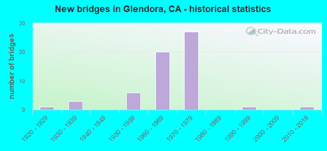
- New bridges - historical statistics
- 11920-1929
- 31930-1939
- 61950-1959
- 201960-1969
- 271970-1979
- 11990-1999
- 12010-2019

- Reconstructed bridges - Historical Statistics
- 11970-1979
- 21980-1989
- 01990-1999
- 02000-2009
- 22010-2019


- Bridge Condition - Deck
- 53.7%Good
- 4.9%Satisfactory
- 39.0%Fair
- 2.4%Poor

- Bridge Condition - Superstructure
- 58.5%Good
- 2.4%Satisfactory
- 36.6%Fair
- 2.4%Poor

- Bridge Condition - Substructure
- 97.6%Good
- 2.4%Satisfactory

- Bridge Condition - Channel
- 75.9%Excellent
- 13.8%Very good
- 10.3%Good

- Bridge Condition - Culverts
- 25.0%Good
- 75.0%Satisfactory
Find on map >> Show street view
Structure Number: 53 0115, Location: 07-LA-039-20.66 (Lat: 34.188717, Lng: -117.868292), Route carried "on" structure: State highway 39, Year Built: 1933, Status: Open, Structure Length: 2.59m (8.50ft), Average Daily Traffic: 1,850 (year 2017), Truck Traffic: 4%, Average Future Daily Traffic: 5,101 (year 2041), Design Load: H 20, Features Intersected: VAN ORNUM CANYON
Minimum Vertical Clearance: 30+ m (98+ ft), Kilometerpoint: 20.660, Lanes on structure: 2, Base Highway Network: Yes (, Subroute: 5), Owner: State Highway Agency, Approaching Roadway Width: 10.4m (34.1ft), Material/Design: Concrete, Design/Construction: Tee Beam, Number Of Spans In Main Unit: 3, Length of Maximum Span: 12.2m (40.0ft), Curb or Sidewalk Widths: Left: 0.2m (0.7ft), Right: 0.2m (0.7ft), Curb-To-Curb Width: 10.4m (34.1ft), Out-to-Out Width: 11.4m (37.4ft)
Condition: Deck: Good, Superstructure: Good, Substructure: Good, Channel: Good, Operating Rating: 35.3 metric tons, Method Used To Determine Operating Rating: Load and Resistance Factor Rating (LRFR) rating reported by rating factor(RF) method using HL-93 loadings, Inventory Rating: 27.2 metric tons, Method Used To Determine Inventory Rating: Load and Resistance Factor Rating (LRFR) rating reported by rating factor(RF) method using HL-93 loadings, Structural Evaluation: Equal to present minimum criteria, Deck Geometry: Equal to present minimum criteria, Waterway Adequacy: Better than present minimum criteria, Approach Roadway Alignment: Superior to present desirable criteria, Designated Inspection Frequency: Every 24 months, Inspection Date: September 2020, Deck Structure Type: Concrete Cast-file-Place, Wearing Surface/Protective System: Wearing Surface: Bituminous
Find on map >> Show street view
Structure Number: 53 0116, Location: 07-LA-039-21.45 (Lat: 34.198314, Lng: -117.862486), Route carried "on" structure: State highway 39, Year Built: 1933, Status: Open, Structure Length: 1.51m (4.95ft), Average Daily Traffic: 1,850 (year 2017), Truck Traffic: 4%, Average Future Daily Traffic: 5,101 (year 2041), Design Load: H 20, Features Intersected: CARPENTER CANYON
Minimum Vertical Clearance: 30+ m (98+ ft), Kilometerpoint: 21.450, Lanes on structure: 2, Base Highway Network: Yes (, Subroute: 5), Owner: State Highway Agency, Approaching Roadway Width: 10.7m (35.1ft), Material/Design: Concrete, Design/Construction: Tee Beam, Number Of Spans In Main Unit: 2, Length of Maximum Span: 7.3m (24.0ft), Curb or Sidewalk Widths: Left: 0.0m, Right: 0.2m (0.7ft), Curb-To-Curb Width: 10.4m (34.1ft), Out-to-Out Width: 11.0m (36.1ft)
Condition: Deck: Good, Superstructure: Good, Substructure: Good, Channel: Good, Operating Rating: 32.4 metric tons, Method Used To Determine Operating Rating: Load and Resistance Factor Rating (LRFR) rating reported by rating factor(RF) method using HL-93 loadings, Inventory Rating: 24.9 metric tons, Method Used To Determine Inventory Rating: Load and Resistance Factor Rating (LRFR) rating reported by rating factor(RF) method using HL-93 loadings, Structural Evaluation: Equal to present minimum criteria, Deck Geometry: Equal to present minimum criteria, Waterway Adequacy: Better than present minimum criteria, Approach Roadway Alignment: Equal to present desirable criteria, Designated Inspection Frequency: Every 24 months, Inspection Date: September 2020, Deck Structure Type: Concrete Cast-file-Place, Wearing Surface/Protective System: Wearing Surface: Bituminous
Find on map >> Show street view
Structure Number: 53 0117, Location: 07-LA-039-22.17 (Lat: 34.203400, Lng: -117.863992), Route carried "on" structure: State highway 39, Year Built: 1933, Status: Open, Structure Length: 0.90m (2.95ft), Average Daily Traffic: 1,850 (year 2017), Truck Traffic: 4%, Average Future Daily Traffic: 5,101 (year 2041), Design Load: H 20, Features Intersected: PEJSA CANYON
Minimum Vertical Clearance: 30+ m (98+ ft), Kilometerpoint: 22.170, Lanes on structure: 2, Base Highway Network: Yes (, Subroute: 5), Owner: State Highway Agency, Approaching Roadway Width: 10.4m (34.1ft), Material/Design: Concrete, Design/Construction: Tee Beam, Number Of Spans In Main Unit: 1, Length of Maximum Span: 8.2m (26.9ft), Curb or Sidewalk Widths: Left: 0.2m (0.7ft), Right: 0.2m (0.7ft), Curb-To-Curb Width: 10.4m (34.1ft), Out-to-Out Width: 11.4m (37.4ft)
Condition: Deck: Good, Superstructure: Good, Substructure: Good, Channel: Good, Operating Rating: 25.9 metric tons, Method Used To Determine Operating Rating: Load and Resistance Factor Rating (LRFR) rating reported by rating factor(RF) method using HL-93 loadings, Inventory Rating: 19.8 metric tons, Method Used To Determine Inventory Rating: Load and Resistance Factor Rating (LRFR) rating reported by rating factor(RF) method using HL-93 loadings, Structural Evaluation: Somewhat better than minimum adequacy, Deck Geometry: Equal to present minimum criteria, Waterway Adequacy: Better than present minimum criteria, Approach Roadway Alignment: Equal to present desirable criteria, Designated Inspection Frequency: Every 24 months, Inspection Date: September 2020, Deck Structure Type: Concrete Cast-file-Place, Wearing Surface/Protective System: Wearing Surface: Bituminous
Find on map >> Show street view
Structure Number: 53 1930L, Location: 07-LA-057-R12.18L-GDR (Lat: 34.121775, Lng: -117.831694), Route carried "on" structure: Ramp State highway 57, Year Built: 1970, Status: Open, Structure Length: 3.80m (12.47ft), Average Daily Traffic: 92,000 (year 2012), Truck Traffic: 7%, Average Future Daily Traffic: 122,095 (year 2040), Design Load: HS 20, Features Intersected: LACMTA & BNSF RY
Minimum Vertical Clearance: 30+ m (98+ ft), Kilometerpoint: 12.180, Lanes on structure: 2, Base Highway Network: Yes (, Subroute: 1), Owner: State Highway Agency, Approaching Roadway Width: 11.9m (39.0ft), Material/Design: Concrete continuous, Design/Construction: Tee Beam, Number Of Spans In Main Unit: 3, Length of Maximum Span: 12.5m (41.0ft), Curb-To-Curb Width: 11.9m (39.0ft), Out-to-Out Width: 12.5m (41.0ft)
Condition: Deck: Good, Superstructure: Good, Substructure: Good, Operating Rating: 34.7 metric tons, Method Used To Determine Operating Rating: Load and Resistance Factor Rating (LRFR) rating reported by rating factor(RF) method using HL-93 loadings, Inventory Rating: 26.9 metric tons, Method Used To Determine Inventory Rating: Load and Resistance Factor Rating (LRFR) rating reported by rating factor(RF) method using HL-93 loadings, Structural Evaluation: Equal to present minimum criteria, Deck Geometry: Superior to present desirable criteria, Underclear: Better than present minimum criteria, Approach Roadway Alignment: Equal to present desirable criteria, Designated Inspection Frequency: Every 24 months, Inspection Date: September 2020, Deck Structure Type: Concrete Cast-file-Place
Find on map >> Show street view
Structure Number: 53 1930R, Location: 07-LA-210-R44.04-GDR (Lat: 34.120494, Lng: -117.831547), Route carried "on" structure: Ramp Interstate 210, Year Built: 1970, Status: Open, Structure Length: 4.42m (14.50ft), Average Daily Traffic: 95,000 (year 2012), Truck Traffic: 7%, Average Future Daily Traffic: 122,502 (year 2039), Design Load: HS 20, Features Intersected: LACMTA & BNSF RY
Minimum Vertical Clearance: 30+ m (98+ ft), Kilometerpoint: 44.040, Lanes on structure: 2, Base Highway Network: Yes (Inventory Route: 2, Subroute: 1), Owner: State Highway Agency, Approaching Roadway Width: 15.5m (50.9ft), Skew: 9 degrees, Material/Design: Concrete continuous, Design/Construction: Tee Beam, Number Of Spans In Main Unit: 3, Length of Maximum Span: 14.6m (47.9ft), Curb-To-Curb Width: 15.5m (50.9ft), Out-to-Out Width: 16.2m (53.1ft)
Condition: Deck: Fair, Superstructure: Good, Substructure: Good, Operating Rating: 35.6 metric tons, Method Used To Determine Operating Rating: Load and Resistance Factor Rating (LRFR) rating reported by rating factor(RF) method using HL-93 loadings, Inventory Rating: 27.5 metric tons, Method Used To Determine Inventory Rating: Load and Resistance Factor Rating (LRFR) rating reported by rating factor(RF) method using HL-93 loadings, Structural Evaluation: Equal to present minimum criteria, Deck Geometry: Superior to present desirable criteria, Underclear: Equal to present minimum criteria, Approach Roadway Alignment: Superior to present desirable criteria, Designated Inspection Frequency: Every 24 months, Inspection Date: Febuary 2021, Deck Structure Type: Concrete Cast-file-Place
Find on map >> Show street view
Structure Number: 53 1971, Location: 07-LA-210-R44.20-GDR (Lat: 34.120797, Lng: -117.829225), Route carried "on" structure: Interstate 210, Year Built: 1970, Status: Open, Structure Length: 5.22m (17.13ft), Average Daily Traffic: 191,000 (year 2012), Truck Traffic: 10%, Average Future Daily Traffic: 221,014 (year 2039), Design Load: HS 20, Features Intersected: LONE HILL AVENUE
Minimum Vertical Clearance: 30+ m (98+ ft), Kilometerpoint: 44.200, Lanes on structure: 10, Lanes under structure: 6, Base Highway Network: Yes (Inventory Route: 2, Subroute: 1), Owner: State Highway Agency, Approaching Roadway Width: 44.4m (145.7ft), Skew: 20 degrees, Material/Design: Concrete continuous, Design/Construction: Box Beam or Girders - Multiple, Number Of Spans In Main Unit: 2, Length of Maximum Span: 26.2m (86.0ft), Curb-To-Curb Width: 44.4m (145.7ft), Out-to-Out Width: 45.1m (148.0ft)
Condition: Deck: Good, Superstructure: Good, Substructure: Good, Operating Rating: 51.8 metric tons, Method Used To Determine Operating Rating: Load and Resistance Factor Rating (LRFR) rating reported by rating factor(RF) method using HL-93 loadings, Inventory Rating: 36.9 metric tons, Method Used To Determine Inventory Rating: Load and Resistance Factor Rating (LRFR) rating reported by rating factor(RF) method using HL-93 loadings, Structural Evaluation: Better than present minimum criteria, Deck Geometry: Superior to present desirable criteria, Underclear: Meets minimum limits, Approach Roadway Alignment: Equal to present desirable criteria, Designated Inspection Frequency: Every 24 months, Inspection Date: Febuary 2021, Deck Structure Type: Concrete Cast-file-Place
Find on map >> Show street view
Structure Number: 53 1971L, Location: 07-LA-057-R12.00L-GDR (Lat: 34.121850, Lng: -117.828642), Route carried "on" structure: Ramp State highway 57, Year Built: 1970, Status: Open, Structure Length: 5.34m (17.52ft), Average Daily Traffic: 92,000 (year 2012), Truck Traffic: 7%, Average Future Daily Traffic: 122,095 (year 2040), Design Load: HS 20, Features Intersected: LONE HILL AVENUE
Minimum Vertical Clearance: 30+ m (98+ ft), Kilometerpoint: 12.000, Lanes on structure: 2, Lanes under structure: 4, Base Highway Network: Yes (, Subroute: 1), Owner: State Highway Agency, Approaching Roadway Width: 11.9m (39.0ft), Skew: 1 degrees, Material/Design: Concrete continuous, Design/Construction: Box Beam or Girders - Multiple, Number Of Spans In Main Unit: 2, Length of Maximum Span: 27.4m (89.9ft), Curb-To-Curb Width: 11.9m (39.0ft), Out-to-Out Width: 12.5m (41.0ft)
Condition: Deck: Good, Superstructure: Fair, Substructure: Good, Operating Rating: 76.5 metric tons, Method Used To Determine Operating Rating: Load Factor (LF), Inventory Rating: 46.0 metric tons, Method Used To Determine Inventory Rating: Load Factor (LF), Structural Evaluation: Somewhat better than minimum adequacy, Deck Geometry: Superior to present desirable criteria, Underclear: Meets minimum limits, Approach Roadway Alignment: Superior to present desirable criteria, Designated Inspection Frequency: Every 24 months, Inspection Date: September 2020, Deck Structure Type: Concrete Cast-file-Place
Find on map >> Show street view
Structure Number: 53 1977L, Location: 07-LA-057-R11.57L-GDR (Lat: 34.117378, Lng: -117.824419), Route carried "on" structure: State highway 57, Year Built: 1971, Status: Open, Structure Length: 4.45m (14.60ft), Average Daily Traffic: 79,000 (year 2012), Truck Traffic: 5%, Average Future Daily Traffic: 73,179 (year 2040), Design Load: HS 20, Features Intersected: AUTO CENTER DRIVE
Minimum Vertical Clearance: 30+ m (98+ ft), Kilometerpoint: 11.570, Lanes on structure: 5, Lanes under structure: 3, Base Highway Network: Yes (, Subroute: 1), Owner: State Highway Agency, Approaching Roadway Width: 31.4m (103.0ft), Skew: 9 degrees, Material/Design: Prestressed concrete, Design/Construction: Box Beam or Girders - Multiple, Number Of Spans In Main Unit: 1, Length of Maximum Span: 43.9m (144.0ft), Curb-To-Curb Width: 31.4m (103.0ft), Out-to-Out Width: 32.0m (105.0ft)
Condition: Deck: Fair, Superstructure: Fair, Substructure: Good, Operating Rating: 52.5 metric tons, Method Used To Determine Operating Rating: Load and Resistance Factor Rating (LRFR) rating reported by rating factor(RF) method using HL-93 loadings, Inventory Rating: 32.7 metric tons, Method Used To Determine Inventory Rating: Load and Resistance Factor Rating (LRFR) rating reported by rating factor(RF) method using HL-93 loadings, Structural Evaluation: Somewhat better than minimum adequacy, Deck Geometry: Superior to present desirable criteria, Underclear: Meets minimum limits, Approach Roadway Alignment: Superior to present desirable criteria, Designated Inspection Frequency: Every 24 months, Inspection Date: September 2020, Deck Structure Type: Concrete Cast-file-Place
Find on map >> Show street view
Structure Number: 53 1977R, Location: 07-LA-057-R11.60R-GDR (Lat: 34.117364, Lng: -117.823761), Route carried "on" structure: State highway 57, Year Built: 1971, Status: Open, Structure Length: 3.81m (12.50ft), Average Daily Traffic: 79,000 (year 2012), Truck Traffic: 5%, Average Future Daily Traffic: 73,179 (year 2040), Design Load: HS 20, Features Intersected: AUTO CENTRE DRIVE
Minimum Vertical Clearance: 30+ m (98+ ft), Kilometerpoint: 11.600, Lanes on structure: 4, Lanes under structure: 4, Base Highway Network: Yes (, Subroute: 1), Owner: State Highway Agency, Approaching Roadway Width: 23.8m (78.1ft), Material/Design: Prestressed concrete, Design/Construction: Box Beam or Girders - Multiple, Number Of Spans In Main Unit: 1, Length of Maximum Span: 37.5m (123.0ft), Curb-To-Curb Width: 21.3m (69.9ft), Out-to-Out Width: 21.9m (71.9ft)
Condition: Deck: Good, Superstructure: Good, Substructure: Good, Operating Rating: 64.2 metric tons, Method Used To Determine Operating Rating: Load and Resistance Factor Rating (LRFR) rating reported by rating factor(RF) method using HL-93 loadings, Inventory Rating: 43.7 metric tons, Method Used To Determine Inventory Rating: Load and Resistance Factor Rating (LRFR) rating reported by rating factor(RF) method using HL-93 loadings, Structural Evaluation: Better than present minimum criteria, Deck Geometry: Better than present minimum criteria, Underclear: Meets minimum limits, Approach Roadway Alignment: Superior to present desirable criteria, Designated Inspection Frequency: Every 24 months, Inspection Date: September 2020, Deck Structure Type: Concrete Cast-file-Place
Find on map >> Show street view
Structure Number: 53 1992L, Location: 07-LA-057-R11.65L-GDR (Lat: 34.118686, Lng: -117.824278), Route carried "on" structure: Ramp State highway 57, Year Built: 1971, Status: Open, Structure Length: 4.60m (15.09ft), Average Daily Traffic: 92,000 (year 2012), Truck Traffic: 7%, Average Future Daily Traffic: 122,095 (year 2040), Design Load: HS 20, Features Intersected: W210-S57 CONNECTOR RAMP
Minimum Vertical Clearance: 30+ m (98+ ft), Kilometerpoint: 11.650, Lanes on structure: 3, Lanes under structure: 2, Base Highway Network: Yes (, Subroute: 1), Owner: State Highway Agency, Approaching Roadway Width: 15.5m (50.9ft), Skew: 5 degrees, Material/Design: Prestressed concrete, Design/Construction: Box Beam or Girders - Multiple, Number Of Spans In Main Unit: 1, Length of Maximum Span: 44.2m (145.0ft), Curb-To-Curb Width: 15.5m (50.9ft), Out-to-Out Width: 16.2m (53.1ft)
Condition: Deck: Good, Superstructure: Good, Substructure: Good, Operating Rating: 63.5 metric tons, Method Used To Determine Operating Rating: Load and Resistance Factor Rating (LRFR) rating reported by rating factor(RF) method using HL-93 loadings, Inventory Rating: 47.6 metric tons, Method Used To Determine Inventory Rating: Load and Resistance Factor Rating (LRFR) rating reported by rating factor(RF) method using HL-93 loadings, Structural Evaluation: Better than present minimum criteria, Deck Geometry: Superior to present desirable criteria, Underclear: Equal to present desirable criteria, Approach Roadway Alignment: Superior to present desirable criteria, Designated Inspection Frequency: Every 24 months, Inspection Date: September 2020, Deck Structure Type: Concrete Cast-file-Place
Find on map >> Show street view
Structure Number: 53 1994, Location: 07-LA-210-R44.71-GDR (Lat: 34.119914, Lng: -117.820408), Route carried "on" structure: Interstate 210, Year Built: 1970, Status: Open, Structure Length: 4.07m (13.35ft), Average Daily Traffic: 179,000 (year 2012), Average Future Daily Traffic: 162,962 (year 2039), Design Load: HS 20, Features Intersected: AMELIA AVENUE
Minimum Vertical Clearance: 30+ m (98+ ft), Kilometerpoint: 44.710, Lanes on structure: 13, Lanes under structure: 4, Base Highway Network: Yes (Inventory Route: 2, Subroute: 1), Owner: State Highway Agency, Approaching Roadway Width: 53.9m (176.8ft), Skew: 30 degrees, Material/Design: Prestressed concrete, Design/Construction: Box Beam or Girders - Multiple, Number Of Spans In Main Unit: 1, Length of Maximum Span: 40.2m (131.9ft), Curb-To-Curb Width: 53.9m (176.8ft), Out-to-Out Width: 54.6m (179.1ft)
Condition: Deck: Good, Superstructure: Good, Substructure: Good, Operating Rating: 90.4 metric tons, Method Used To Determine Operating Rating: Load Factor (LF), Inventory Rating: 32.4 metric tons, Method Used To Determine Inventory Rating: Load Factor (LF), Structural Evaluation: Better than present minimum criteria, Deck Geometry: Equal to present minimum criteria, Underclear: Somewhat better than minimum adequacy, Approach Roadway Alignment: Equal to present desirable criteria, Designated Inspection Frequency: Every 24 months, Inspection Date: Febuary 2021, Deck Structure Type: Concrete Cast-file-Place
Find on map >> Show street view
Structure Number: 53 1995, Location: 07-LA-210-R44.72-GDR (Lat: 34.120914, Lng: -117.820317), Route carried "on" structure: City street L536, Year Built: 1970, Status: Open, Structure Length: 2.79m (9.15ft), Average Daily Traffic: 3,400 (year 2012), Truck Traffic: 2%, Average Future Daily Traffic: 5,251 (year 2039), Design Load: HS 20, Features Intersected: W210-S57 CONNECTOR RAMP, Facility Carried by Structure: AMELIA AVE
Minimum Vertical Clearance: 30+ m (98+ ft), Kilometerpoint: 0.000, Lanes on structure: 4, Lanes under structure: 2, Owner: State Highway Agency, Approaching Roadway Width: 23.1m (75.8ft), Skew: 1 degrees, Material/Design: Prestressed concrete, Design/Construction: Box Beam or Girders - Multiple, Number Of Spans In Main Unit: 1, Length of Maximum Span: 26.8m (87.9ft), Curb or Sidewalk Widths: Left: 1.8m (5.9ft), Right: 1.8m (5.9ft), Curb-To-Curb Width: 23.1m (75.8ft), Out-to-Out Width: 23.8m (78.1ft)
Condition: Deck: Fair, Superstructure: Good, Substructure: Good, Operating Rating: 39.9 metric tons, Method Used To Determine Operating Rating: Load and Resistance Factor Rating (LRFR) rating reported by rating factor(RF) method using HL-93 loadings, Inventory Rating: 25.6 metric tons, Method Used To Determine Inventory Rating: Load and Resistance Factor Rating (LRFR) rating reported by rating factor(RF) method using HL-93 loadings, Structural Evaluation: Equal to present minimum criteria, Deck Geometry: Superior to present desirable criteria, Underclear: Better than present minimum criteria, Approach Roadway Alignment: Equal to present desirable criteria, Designated Inspection Frequency: Every 24 months, Inspection Date: Febuary 2021, Deck Structure Type: Concrete Cast-file-Place
Find on map >> Show street view
Structure Number: 53 1996, Location: 07-LA-210-R44.43-GDR (Lat: 34.120544, Lng: -117.826136), Route carried "on" structure: Interstate 210, Year Built: 1970, Status: Open, Structure Length: 1.06m (3.48ft), Average Daily Traffic: 191,000 (year 2012), Truck Traffic: 8%, Average Future Daily Traffic: 221,014 (year 2039), Design Load: HS 20, Features Intersected: SAN DIMAS CHANNEL
Minimum Vertical Clearance: 30+ m (98+ ft), Kilometerpoint: 44.430, Lanes on structure: 11, Base Highway Network: Yes (Inventory Route: 2, Subroute: 1), Owner: State Highway Agency, Approaching Roadway Width: 48.1m (157.8ft), Skew: 27 degrees, Material/Design: Concrete, Design/Construction: Frame, Number Of Spans In Main Unit: 1, Length of Maximum Span: 9.4m (30.8ft)
Condition: Deck: Good, Superstructure: Good, Substructure: Good, Channel: Very good, Operating Rating: 54.1 metric tons, Method Used To Determine Operating Rating: Field evaluation and documented engineering judgment, Inventory Rating: 32.4 metric tons, Method Used To Determine Inventory Rating: Field evaluation and documented engineering judgment, Structural Evaluation: Better than present minimum criteria, Waterway Adequacy: Equal to present desirable criteria, Approach Roadway Alignment: Equal to present desirable criteria, Designated Inspection Frequency: Every 24 months, Inspection Date: Febuary 2021
Find on map >> Show street view
Structure Number: 53 2013R, Location: 07-LA-210-R44.20-GDR (Lat: 34.120225, Lng: -117.829211), Route carried "on" structure: Ramp Interstate 210, Year Built: 1970, Status: Open, Structure Length: 20.58m (67.52ft), Average Daily Traffic: 70,000 (year 2017), Truck Traffic: 7%, Average Future Daily Traffic: 76,768 (year 2042), Design Load: HS 20, Features Intersected: SAN DIMAS CH, LONE HILL
Minimum Vertical Clearance: 30+ m (98+ ft), Kilometerpoint: 44.200, Lanes on structure: 2, Lanes under structure: 5, Base Highway Network: Yes (Inventory Route: 2, Subroute: 1), Owner: State Highway Agency, Approaching Roadway Width: 11.9m (39.0ft), Skew: 9 degrees, Material/Design: Prestressed concrete continuous, Design/Construction: Box Beam or Girders - Multiple, Number Of Spans In Main Unit: 2, Number Of Approach Spans: 4, Length of Maximum Span: 44.5m (146.0ft), Curb-To-Curb Width: 11.9m (39.0ft), Out-to-Out Width: 12.5m (41.0ft)
Condition: Deck: Fair, Superstructure: Fair, Substructure: Good, Channel: Very good, Operating Rating: 71.6 metric tons, Method Used To Determine Operating Rating: Load Factor (LF), Inventory Rating: 32.4 metric tons, Method Used To Determine Inventory Rating: Load Factor (LF), Structural Evaluation: Somewhat better than minimum adequacy, Deck Geometry: Superior to present desirable criteria, Underclear: Meets minimum limits, Waterway Adequacy: Equal to present desirable criteria, Approach Roadway Alignment: Equal to present desirable criteria, Designated Inspection Frequency: Every 24 months, Inspection Date: Febuary 2021, Deck Structure Type: Concrete Cast-file-Place
Find on map >> Show street view
Structure Number: 53 2025, Location: 07-LA-210-R42.66-GDR (Lat: 34.117389, Lng: -117.855261), Route carried "on" structure: Interstate 210, Year Built: 1970, Status: Open, Structure Length: 3.20m (10.50ft), Average Daily Traffic: 256,000 (year 2017), Average Future Daily Traffic: 414,347 (year 2043), Design Load: HS 20, Features Intersected: BONNIE COVE
Minimum Vertical Clearance: 30+ m (98+ ft), Kilometerpoint: 42.660, Lanes on structure: 10, Lanes under structure: 2, Base Highway Network: Yes (Inventory Route: 2, Subroute: 1), Owner: State Highway Agency, Approaching Roadway Width: 44.5m (146.0ft), Skew: 30 degrees, Material/Design: Prestressed concrete, Design/Construction: Box Beam or Girders - Multiple, Number Of Spans In Main Unit: 1, Length of Maximum Span: 31.4m (103.0ft), Curb-To-Curb Width: 43.9m (144.0ft), Out-to-Out Width: 45.1m (148.0ft)
Condition: Deck: Good, Superstructure: Fair, Substructure: Good, Operating Rating: 38.2 metric tons, Method Used To Determine Operating Rating: Load and Resistance Factor Rating (LRFR) rating reported by rating factor(RF) method using HL-93 loadings, Inventory Rating: 26.2 metric tons, Method Used To Determine Inventory Rating: Load and Resistance Factor Rating (LRFR) rating reported by rating factor(RF) method using HL-93 loadings, Structural Evaluation: Somewhat better than minimum adequacy, Deck Geometry: Better than present minimum criteria, Underclear: Better than present minimum criteria, Approach Roadway Alignment: Equal to present desirable criteria, Designated Inspection Frequency: Every 24 months, Inspection Date: Febuary 2021, Deck Structure Type: Concrete Cast-file-Place
Find on map >> Show street view
Structure Number: 53 2040L, Location: 07-LA-210-R27.41-PAS (Lat: 34.152503, Lng: -118.113511), Route carried "on" structure: Interstate 210, Year Built: 1976, Status: Open, Structure Length: 5.76m (18.90ft), Average Daily Traffic: 147,000 (year 2015), Truck Traffic: 5%, Average Future Daily Traffic: 144,910 (year 2042), Design Load: HS 20, Features Intersected: ALLEN AVE
Minimum Vertical Clearance: 30+ m (98+ ft), Kilometerpoint: 27.410, Lanes on structure: 7, Lanes under structure: 6, Base Highway Network: Yes (Inventory Route: 2, Subroute: 1), Owner: State Highway Agency, Approaching Roadway Width: 24.7m (81.0ft), Skew: 30 degrees, Material/Design: Concrete continuous, Design/Construction: Box Beam or Girders - Multiple, Number Of Spans In Main Unit: 2, Length of Maximum Span: 28.7m (94.2ft), Curb-To-Curb Width: 24.7m (81.0ft), Out-to-Out Width: 26.3m (86.3ft)
Condition: Deck: Fair, Superstructure: Fair, Substructure: Good, Operating Rating: 57.0 metric tons, Method Used To Determine Operating Rating: Load and Resistance Factor Rating (LRFR) rating reported by rating factor(RF) method using HL-93 loadings, Inventory Rating: 44.1 metric tons, Method Used To Determine Inventory Rating: Load and Resistance Factor Rating (LRFR) rating reported by rating factor(RF) method using HL-93 loadings, Structural Evaluation: Somewhat better than minimum adequacy, Deck Geometry: High priority of replacement, Underclear: Somewhat better than minimum adequacy, Approach Roadway Alignment: Equal to present desirable criteria, Designated Inspection Frequency: Every 24 months, Inspection Date: September 2021, Deck Structure Type: Concrete Cast-file-Place
Find on map >> Show street view
Structure Number: 53 2048, Location: 07-LA-210-R41.59-GDR (Lat: 34.120361, Lng: -117.872892), Route carried "on" structure: Interstate 210, Year Built: 1969, Year Reconstructed: 2010, Status: Open, Structure Length: 4.57m (14.99ft), Average Daily Traffic: 250,000 (year 2015), Average Future Daily Traffic: 231,417 (year 2042), Design Load: HS 20, Features Intersected: GRAND AVENUE
Minimum Vertical Clearance: 30+ m (98+ ft), Kilometerpoint: 41.590, Lanes on structure: 12, Lanes under structure: 6, Base Highway Network: Yes (Inventory Route: 2, Subroute: 1), Owner: State Highway Agency, Approaching Roadway Width: 58.8m (192.9ft), Skew: 30 degrees, Material/Design: Concrete continuous, Design/Construction: Box Beam or Girders - Multiple, Number Of Spans In Main Unit: 2, Length of Maximum Span: 25.3m (83.0ft), Curb-To-Curb Width: 58.1m (190.6ft), Out-to-Out Width: 60.1m (197.2ft)
Condition: Deck: Fair, Superstructure: Good, Substructure: Good, Operating Rating: 54.1 metric tons, Method Used To Determine Operating Rating: Assigned rating based on Load Factor Design (LFD) reported in metric tons, Inventory Rating: 32.4 metric tons, Method Used To Determine Inventory Rating: Assigned rating based on Load Factor Design (LFD) reported in metric tons, Structural Evaluation: Better than present minimum criteria, Deck Geometry: Superior to present desirable criteria, Underclear: Somewhat better than minimum adequacy, Approach Roadway Alignment: Equal to present desirable criteria, Designated Inspection Frequency: Every 24 months, Inspection Date: March 2021, Deck Structure Type: Concrete Cast-file-Place
Find on map >> Show street view
Structure Number: 53 2049, Location: 07-LA-210-R41.11-GDR (Lat: 34.121278, Lng: -117.881517), Route carried "on" structure: City street L380, Year Built: 1969, Status: Open, Structure Length: 6.60m (21.65ft), Average Daily Traffic: 18,500 (year 2015), Truck Traffic: 2%, Average Future Daily Traffic: 25,754 (year 2042), Design Load: HS 20, Features Intersected: INTERSTATE 210, Facility Carried by Structure: BARRANCA AVENUE
Minimum Vertical Clearance: 30+ m (98+ ft), Kilometerpoint: 0.000, Lanes on structure: 5, Lanes under structure: 10, Owner: State Highway Agency, Approaching Roadway Width: 19.5m (64.0ft), Material/Design: Concrete continuous, Design/Construction: Box Beam or Girders - Multiple, Number Of Spans In Main Unit: 2, Length of Maximum Span: 33.2m (108.9ft), Curb or Sidewalk Widths: Left: 1.5m (4.9ft), Right: 1.5m (4.9ft), Curb-To-Curb Width: 19.5m (64.0ft), Out-to-Out Width: 23.2m (76.1ft)
Condition: Deck: Fair, Superstructure: Fair, Substructure: Good, Operating Rating: 56.4 metric tons, Method Used To Determine Operating Rating: Load and Resistance Factor Rating (LRFR) rating reported by rating factor(RF) method using HL-93 loadings, Inventory Rating: 43.4 metric tons, Method Used To Determine Inventory Rating: Load and Resistance Factor Rating (LRFR) rating reported by rating factor(RF) method using HL-93 loadings, Structural Evaluation: Somewhat better than minimum adequacy, Deck Geometry: Meets minimum limits, Underclear: Meets minimum limits, Approach Roadway Alignment: Superior to present desirable criteria, Designated Inspection Frequency: Every 24 months, Inspection Date: March 2021, Deck Structure Type: Concrete Cast-file-Place
Find on map >> Show street view
Structure Number: 53 2060K, Location: 07-LA-210-R41.87-GDR (Lat: 34.120072, Lng: -117.867942), Route carried "on" structure: Bypass Interstate 210, Year Built: 1969, Year Reconstructed: 2010, Status: Open, Structure Length: 4.11m (13.48ft), Average Daily Traffic: 9,500 (year 2015), Truck Traffic: 2%, Average Future Daily Traffic: 10,019 (year 2042), Design Load: HS 20, Features Intersected: BIG DALTON WASH
Minimum Vertical Clearance: 30+ m (98+ ft), Kilometerpoint: 41.870, Lanes on structure: 2, Base Highway Network: Yes (Inventory Route: 2, Subroute: 1), Owner: State Highway Agency, Approaching Roadway Width: 11.5m (37.7ft), Skew: 2 degrees, Material/Design: Concrete continuous, Design/Construction: Box Beam or Girders - Multiple, Number Of Spans In Main Unit: 3, Length of Maximum Span: 21.6m (70.9ft), Curb-To-Curb Width: 11.5m (37.7ft), Out-to-Out Width: 12.3m (40.4ft)
Condition: Deck: Good, Superstructure: Good, Substructure: Good, Channel: Very good, Operating Rating: 63.5 metric tons, Method Used To Determine Operating Rating: Load Factor (LF), Inventory Rating: 38.2 metric tons, Method Used To Determine Inventory Rating: Load Factor (LF), Structural Evaluation: Better than present minimum criteria, Deck Geometry: Somewhat better than minimum adequacy, Waterway Adequacy: Equal to present desirable criteria, Approach Roadway Alignment: Equal to present desirable criteria, Designated Inspection Frequency: Every 24 months, Inspection Date: March 2021, Deck Structure Type: Concrete Cast-file-Place
Find on map >> Show street view
Structure Number: 53 2061, Location: 07-LA-210-R43.16-GDR (Lat: 34.117406, Lng: -117.846589), Route carried "on" structure: Interstate 210, Year Built: 1970, Status: Open, Structure Length: 4.26m (13.98ft), Average Daily Traffic: 257,000 (year 2017), Truck Traffic: 7%, Average Future Daily Traffic: 415,965 (year 2043), Design Load: HS 20, Features Intersected: SUNFLOWER AVENUE
Minimum Vertical Clearance: 30+ m (98+ ft), Kilometerpoint: 43.160, Lanes on structure: 10, Lanes under structure: 4, Base Highway Network: Yes (Inventory Route: 2, Subroute: 1), Owner: State Highway Agency, Approaching Roadway Width: 44.5m (146.0ft), Skew: 39 degrees, Material/Design: Prestressed concrete, Design/Construction: Box Beam or Girders - Multiple, Number Of Spans In Main Unit: 1, Length of Maximum Span: 42.1m (138.1ft), Curb-To-Curb Width: 43.9m (144.0ft), Out-to-Out Width: 45.1m (148.0ft)
Condition: Deck: Good, Superstructure: Good, Substructure: Good, Operating Rating: 31.1 metric tons, Method Used To Determine Operating Rating: Load and Resistance Factor Rating (LRFR) rating reported by rating factor(RF) method using HL-93 loadings, Inventory Rating: 22.4 metric tons, Method Used To Determine Inventory Rating: Load and Resistance Factor Rating (LRFR) rating reported by rating factor(RF) method using HL-93 loadings, Structural Evaluation: Somewhat better than minimum adequacy, Deck Geometry: Better than present minimum criteria, Underclear: Equal to present minimum criteria, Approach Roadway Alignment: Equal to present desirable criteria, Designated Inspection Frequency: Every 24 months, Inspection Date: Febuary 2021, Deck Structure Type: Concrete Cast-file-Place
Find on map >> Show street view
Structure Number: 53 2072, Location: 07-LA-210-R42.10-GDR (Lat: 34.117844, Lng: -117.864667), Route carried "on" structure: Interstate 210, Year Built: 1970, Status: Open, Structure Length: 4.79m (15.72ft), Average Daily Traffic: 250,000 (year 2015), Average Future Daily Traffic: 231,417 (year 2042), Design Load: HS 20, Features Intersected: GLENDORA AVENUE
Minimum Vertical Clearance: 30+ m (98+ ft), Kilometerpoint: 42.100, Lanes on structure: 10, Lanes under structure: 4, Base Highway Network: Yes (Inventory Route: 2, Subroute: 1), Owner: State Highway Agency, Approaching Roadway Width: 43.9m (144.0ft), Skew: 33 degrees, Material/Design: Prestressed concrete, Design/Construction: Box Beam or Girders - Multiple, Number Of Spans In Main Unit: 1, Length of Maximum Span: 46.6m (152.9ft), Curb-To-Curb Width: 43.9m (144.0ft), Out-to-Out Width: 45.1m (148.0ft)
Condition: Deck: Fair, Superstructure: Fair, Substructure: Good, Operating Rating: 63.5 metric tons, Method Used To Determine Operating Rating: Load and Resistance Factor Rating (LRFR) rating reported by rating factor(RF) method using HL-93 loadings, Inventory Rating: 41.5 metric tons, Method Used To Determine Inventory Rating: Load and Resistance Factor Rating (LRFR) rating reported by rating factor(RF) method using HL-93 loadings, Structural Evaluation: Somewhat better than minimum adequacy, Deck Geometry: Better than present minimum criteria, Underclear: Somewhat better than minimum adequacy, Approach Roadway Alignment: Equal to present desirable criteria, Designated Inspection Frequency: Every 24 months, Inspection Date: March 2021, Deck Structure Type: Concrete Cast-file-Place
Find on map >> Show street view
Structure Number: 53 3096R, Location: 07-LA-039-21.67 (Lat: 34.200064, Lng: -117.859906), Route carried "on" structure: State highway 39, Year Built: 2016, Status: Open, Structure Length: 2.04m (6.69ft), Average Daily Traffic: 850 (year 2017), Truck Traffic: 4%, Average Future Daily Traffic: 2,542 (year 2040), Design Load: HL 93, Features Intersected: SAN GABRIEL CANYON
Minimum Vertical Clearance: 30+ m (98+ ft), Kilometerpoint: 21.670, Lanes on structure: 2, Base Highway Network: Yes, Owner: State Highway Agency, Approaching Roadway Width: 4.9m (16.1ft), Material/Design: Concrete continuous, Design/Construction: Slab, Number Of Spans In Main Unit: 4, Number Of Approach Spans: 2, Length of Maximum Span: 4.6m (15.1ft), Curb-To-Curb Width: 4.9m (16.1ft), Out-to-Out Width: 4.6m (15.1ft)
Condition: Deck: Good, Superstructure: Good, Substructure: Good, Operating Rating: 42.1 metric tons, Method Used To Determine Operating Rating: Assigned ratings based on Load and Resistance Factor Design (LRFD) reported by rating factor (RF) using HL93 loadings, Inventory Rating: 32.4 metric tons, Method Used To Determine Inventory Rating: Assigned ratings based on Load and Resistance Factor Design (LRFD) reported by rating factor (RF) using HL93 loadings, Structural Evaluation: Better than present minimum criteria, Deck Geometry: High priority of replacement, Approach Roadway Alignment: Equal to present desirable criteria, Designated Inspection Frequency: Every 48 months, Inspection Date: October 2018, Deck Structure Type: Concrete Cast-file-Place
Find on map >> Show street view
Structure Number: 53C0501, Location: 0.2MI W/O MOUNTAIN AVE (Lat: 34.132175, Lng: -117.989369), Route carried "on" structure: City street L517, Year Built: 1952, Status: Open, Structure Length: 1.58m (5.18ft), Average Daily Traffic: 8,998 (year 2016), Truck Traffic: 1%, Average Future Daily Traffic: 10,348 (year 2041), Design Load: HS 20, Features Intersected: SAWPIT WASH, Facility Carried by Structure: DUARTE RD
Minimum Vertical Clearance: 30.47m (99.97ft), Kilometerpoint: 0.000, Lanes on structure: 2, Owner: City or Municipal Highway Agency, Approaching Roadway Width: 14.6m (47.9ft), Material/Design: Concrete, Design/Construction: Slab, Number Of Spans In Main Unit: 1, Length of Maximum Span: 13.4m (44.0ft), Curb or Sidewalk Widths: Left: 1.2m (3.9ft), Right: 0.4m (1.3ft), Curb-To-Curb Width: 14.6m (47.9ft), Out-to-Out Width: 17.7m (58.1ft)
Condition: Deck: Fair, Superstructure: Fair, Substructure: Good, Channel: Excellent, Operating Rating: 56.4 metric tons, Method Used To Determine Operating Rating: Load Factor (LF), Inventory Rating: 33.7 metric tons, Method Used To Determine Inventory Rating: Load Factor (LF), Structural Evaluation: Somewhat better than minimum adequacy, Deck Geometry: Superior to present desirable criteria, Waterway Adequacy: Equal to present desirable criteria, Approach Roadway Alignment: Better than present minimum criteria, Designated Inspection Frequency: Every 24 months, Inspection Date: May 2021, Deck Structure Type: Concrete Cast-file-Place, Wearing Surface/Protective System: Wearing Surface: Monolithic Concrete
Find on map >> Show street view
Structure Number: 53C0502, Location: 0.4MI E/O LORAINE AVE (Lat: 34.136019, Lng: -117.839139), Route carried "on" structure: City street , Year Built: 1960, Status: Open, Structure Length: 0.73m (2.40ft), Average Daily Traffic: 12,607 (year 2012), Truck Traffic: 2%, Average Future Daily Traffic: 14,498 (year 2040), Design Load: HS 20, Features Intersected: BIG DALTON WASH, Facility Carried by Structure: FOOTHILL BLVD
Minimum Vertical Clearance: 30.47m (99.97ft), Kilometerpoint: 0.000, Lanes on structure: 2, Owner: City or Municipal Highway Agency, Approaching Roadway Width: 19.6m (64.3ft), Skew: 2 degrees, Material/Design: Concrete, Design/Construction: Slab, Number Of Spans In Main Unit: 1, Length of Maximum Span: 6.4m (21.0ft), Curb or Sidewalk Widths: Left: 1.6m (5.2ft), Right: 1.6m (5.2ft), Curb-To-Curb Width: 19.6m (64.3ft), Out-to-Out Width: 23.7m (77.8ft)
Condition: Deck: Fair, Superstructure: Fair, Substructure: Good, Channel: Excellent, Operating Rating: 53.8 metric tons, Method Used To Determine Operating Rating: Load Factor (LF), Inventory Rating: 32.1 metric tons, Method Used To Determine Inventory Rating: Load Factor (LF), Structural Evaluation: Somewhat better than minimum adequacy, Deck Geometry: Superior to present desirable criteria, Waterway Adequacy: Superior to present desirable criteria, Approach Roadway Alignment: Equal to present desirable criteria, Designated Inspection Frequency: Every 24 months, Inspection Date: January 2021, Deck Structure Type: Concrete Cast-file-Place
Find on map >> Show street view
Structure Number: 53C0509, Location: 100FT N/O ARROW HWY (Lat: 34.106497, Lng: -117.872467), Route carried "on" structure: City street L381, Year Built: 1959, Status: Open, Structure Length: 0.86m (2.82ft), Average Daily Traffic: 23,056 (year 2017), Truck Traffic: 4%, Average Future Daily Traffic: 34,287 (year 2040), Design Load: HS 20, Features Intersected: SAN DIMAS WASH, Facility Carried by Structure: GRAND AVE
Minimum Vertical Clearance: 30+ m (98+ ft), Kilometerpoint: 0.000, Lanes on structure: 5, Owner: City or Municipal Highway Agency, Approaching Roadway Width: 24.4m (80.1ft), Skew: 20 degrees, Material/Design: Concrete, Design/Construction: Slab, Number Of Spans In Main Unit: 1, Length of Maximum Span: 7.6m (24.9ft), Curb or Sidewalk Widths: Left: 1.5m (4.9ft), Right: 1.5m (4.9ft), Curb-To-Curb Width: 22.6m (74.1ft), Out-to-Out Width: 28.1m (92.2ft)
Condition: Deck: Good, Superstructure: Good, Substructure: Good, Channel: Excellent, Operating Rating: 66.1 metric tons, Method Used To Determine Operating Rating: Load Factor (LF), Inventory Rating: 39.5 metric tons, Method Used To Determine Inventory Rating: Load Factor (LF), Structural Evaluation: Better than present minimum criteria, Deck Geometry: Equal to present minimum criteria, Waterway Adequacy: Superior to present desirable criteria, Approach Roadway Alignment: Equal to present desirable criteria, Designated Inspection Frequency: Every 48 months, Inspection Date: January 2021, Deck Structure Type: Concrete Cast-file-Place, Wearing Surface/Protective System: Wearing Surface: Bituminous
Find on map >> Show street view
Structure Number: 53C053, Location: 0.1 MI WEST OF ARLETA AVE (Lat: 34.246808, Lng: -118.433894), Route carried "on" structure: City street , Year Built: 1954, Year Reconstructed: 1979, Status: Open, Structure Length: 2.71m (8.89ft), Average Daily Traffic: 14,256 (year 2010), Truck Traffic: 1%, Average Future Daily Traffic: 17,168 (year 2036), Design Load: HS 20, Features Intersected: PACOIMA DIVERSION CHAN, Facility Carried by Structure: TERRA BELLA ST
Minimum Vertical Clearance: 30+ m (98+ ft), Kilometerpoint: 0.000, Lanes on structure: 4, Owner: City or Municipal Highway Agency, Approaching Roadway Width: 18.9m (62.0ft), Material/Design: Steel, Design/Construction: Stringer/Multi-beam, Number Of Spans In Main Unit: 1, Length of Maximum Span: 25.9m (85.0ft), Curb or Sidewalk Widths: Left: 2.1m (6.9ft), Right: 2.1m (6.9ft), Curb-To-Curb Width: 20.1m (65.9ft), Out-to-Out Width: 25.1m (82.3ft)
Condition: Deck: Good, Superstructure: Good, Substructure: Good, Channel: Very good, Operating Rating: 54.1 metric tons, Method Used To Determine Operating Rating: Load Factor (LF), Inventory Rating: 32.4 metric tons, Method Used To Determine Inventory Rating: Load Factor (LF), Structural Evaluation: Better than present minimum criteria, Deck Geometry: Better than present minimum criteria, Waterway Adequacy: Equal to present desirable criteria, Approach Roadway Alignment: Equal to present desirable criteria, Designated Inspection Frequency: Every 48 months, Inspection Date: January 2019, Deck Structure Type: Concrete Cast-file-Place, Wearing Surface/Protective System: Wearing Surface: Bituminous
Find on map >> Show street view
Structure Number: 53C0532, Location: 1.1MI E/O GLENDORA RD (Lat: 34.128686, Lng: -117.844131), Route carried "on" structure: City street , Year Built: 1959, Year Reconstructed: 1992, Status: Open, Structure Length: 1.18m (3.87ft), Average Daily Traffic: 33,125 (year 2012), Truck Traffic: 4%, Average Future Daily Traffic: 39,750 (year 2040), Design Load: HS 20, Features Intersected: BIG DALTON WASH, Facility Carried by Structure: ALOSTA AVE
Minimum Vertical Clearance: 30.47m (99.97ft), Kilometerpoint: 0.000, Lanes on structure: 4, Owner: City or Municipal Highway Agency, Approaching Roadway Width: 21.3m (69.9ft), Skew: 24 degrees, Material/Design: Concrete, Design/Construction: Slab, Number Of Spans In Main Unit: 1, Length of Maximum Span: 9.8m (32.2ft), Curb or Sidewalk Widths: Left: 1.9m (6.2ft), Right: 1.9m (6.2ft), Curb-To-Curb Width: 21.3m (69.9ft), Out-to-Out Width: 29.4m (96.5ft)
Condition: Deck: Good, Superstructure: Good, Substructure: Good, Channel: Excellent, Operating Rating: 56.1 metric tons, Method Used To Determine Operating Rating: Load Factor (LF), Inventory Rating: 33.7 metric tons, Method Used To Determine Inventory Rating: Load Factor (LF), Structural Evaluation: Better than present minimum criteria, Deck Geometry: Superior to present desirable criteria, Waterway Adequacy: Superior to present desirable criteria, Approach Roadway Alignment: Equal to present desirable criteria, Designated Inspection Frequency: Every 48 months, Inspection Date: January 2021, Deck Structure Type: Concrete Cast-file-Place, Wearing Surface/Protective System: Wearing Surface: Bituminous
Find on map >> Show street view
Structure Number: 53C0533, Location: 1.2MI E/O GLENDORA AVE (Lat: 34.128722, Lng: -117.840311), Route carried "on" structure: City street L535, Year Built: 1968, Status: Open, Structure Length: 1.16m (3.81ft), Average Daily Traffic: 30,352 (year 2017), Truck Traffic: 4%, Average Future Daily Traffic: 39,750 (year 2040), Features Intersected: E BRANCH BIG DALTON WASH, Facility Carried by Structure: ALOSTA AVE
Minimum Vertical Clearance: 30+ m (98+ ft), Kilometerpoint: 0.000, Lanes on structure: 4, Owner: City or Municipal Highway Agency, Approaching Roadway Width: 21.3m (69.9ft), Skew: 25 degrees, Material/Design: Concrete, Design/Construction: Culvert, Number Of Spans In Main Unit: 2, Length of Maximum Span: 10.8m (35.4ft), Curb or Sidewalk Widths: Left: 2.5m (8.2ft), Right: 3.0m (9.8ft), Curb-To-Curb Width: 23.6m (77.4ft), Out-to-Out Width: 30.6m (100.4ft)
Condition: Channel: Excellent, Culverts: Good, Operating Rating: 40.5 metric tons, Method Used To Determine Operating Rating: Field evaluation and documented engineering judgment, Inventory Rating: 24.3 metric tons, Method Used To Determine Inventory Rating: Field evaluation and documented engineering judgment, Structural Evaluation: Equal to present minimum criteria, Deck Geometry: Superior to present desirable criteria, Waterway Adequacy: Superior to present desirable criteria, Approach Roadway Alignment: Equal to present desirable criteria, Designated Inspection Frequency: Every 48 months, Inspection Date: January 2021
Find on map >> Show street view
Structure Number: 53C0672L, Location: 0.3MI S/O I-10 FWY (Lat: 34.116025, Lng: -117.881283), Route carried "on" structure: County highway L380, Year Built: 1975, Status: Open, Structure Length: 1.19m (3.90ft), Average Daily Traffic: 8,524 (year 2012), Truck Traffic: 2%, Average Future Daily Traffic: 9,803 (year 2040), Design Load: HS 20, Features Intersected: BIG DALTON WASH, Facility Carried by Structure: BARANCA AVE S
Minimum Vertical Clearance: 30.47m (99.97ft), Kilometerpoint: 0.000, Lanes on structure: 2, Owner: County Highway Agency, Approaching Roadway Width: 9.4m (30.8ft), Skew: 3 degrees, Material/Design: Concrete, Design/Construction: Slab, Number Of Spans In Main Unit: 1, Length of Maximum Span: 11.3m (37.1ft), Curb or Sidewalk Widths: Left: 1.5m (4.9ft), Right: 0.8m (2.6ft), Curb-To-Curb Width: 9.6m (31.5ft), Out-to-Out Width: 12.2m (40.0ft)
Condition: Deck: Satisfactory, Superstructure: Satisfactory, Substructure: Good, Channel: Excellent, Operating Rating: 54.8 metric tons, Method Used To Determine Operating Rating: Load Factor (LF), Inventory Rating: 32.7 metric tons, Method Used To Determine Inventory Rating: Load Factor (LF), Structural Evaluation: Equal to present minimum criteria, Deck Geometry: Meets minimum limits, Waterway Adequacy: Superior to present desirable criteria, Approach Roadway Alignment: Equal to present desirable criteria, Designated Inspection Frequency: Every 48 months, Inspection Date: April 2020, Deck Structure Type: Concrete Cast-file-Place, Wearing Surface/Protective System: Wearing Surface: Monolithic Concrete
Find on map >> Show street view
Structure Number: 53C0672R, Location: 0.1MI N/O GLADESTONE ST (Lat: 34.116019, Lng: -117.881283), Route carried "on" structure: City street , Year Built: 1960, Status: Open, Structure Length: 1.19m (3.90ft), Average Daily Traffic: 20,785 (year 2012), Truck Traffic: 2%, Average Future Daily Traffic: 24,942 (year 2040), Design Load: HS 20, Features Intersected: BIG DALTON WASH, Facility Carried by Structure: BARRANCA AVE N
Minimum Vertical Clearance: 30.47m (99.97ft), Kilometerpoint: 0.000, Lanes on structure: 2, Owner: City or Municipal Highway Agency, Approaching Roadway Width: 9.1m (29.9ft), Skew: 3 degrees, Material/Design: Concrete, Design/Construction: Slab, Number Of Spans In Main Unit: 1, Length of Maximum Span: 11.0m (36.1ft), Curb or Sidewalk Widths: Left: 0.9m (3.0ft), Right: 1.5m (4.9ft), Curb-To-Curb Width: 9.1m (29.9ft), Out-to-Out Width: 11.8m (38.7ft)
Condition: Deck: Fair, Superstructure: Fair, Substructure: Good, Channel: Excellent, Operating Rating: 77.1 metric tons, Method Used To Determine Operating Rating: Load Factor (LF), Inventory Rating: 46.0 metric tons, Method Used To Determine Inventory Rating: Load Factor (LF), Structural Evaluation: Somewhat better than minimum adequacy, Deck Geometry: Meets minimum limits, Waterway Adequacy: Superior to present desirable criteria, Approach Roadway Alignment: Equal to present desirable criteria, Designated Inspection Frequency: Every 24 months, Inspection Date: January 2021, Deck Structure Type: Concrete Cast-file-Place
Find on map >> Show street view
Structure Number: 53C0682, Location: 0.5MI S/O ALOSTA AVE (Lat: 34.121933, Lng: -117.863819), Route carried "on" structure: City street , Year Built: 1960, Status: Open, Structure Length: 1.13m (3.71ft), Average Daily Traffic: 18,334 (year 2012), Truck Traffic: 1%, Average Future Daily Traffic: 22,001 (year 2040), Design Load: HS 20, Features Intersected: BIG DALTON WASH, Facility Carried by Structure: GLENDORA AVE
Minimum Vertical Clearance: 30.47m (99.97ft), Kilometerpoint: 0.000, Lanes on structure: 5, Owner: City or Municipal Highway Agency, Approaching Roadway Width: 18.3m (60.0ft), Skew: 2 degrees, Material/Design: Concrete, Design/Construction: Slab, Number Of Spans In Main Unit: 1, Length of Maximum Span: 10.4m (34.1ft), Curb or Sidewalk Widths: Left: 1.6m (5.2ft), Right: 1.6m (5.2ft), Curb-To-Curb Width: 18.3m (60.0ft), Out-to-Out Width: 21.9m (71.9ft)
Condition: Deck: Fair, Superstructure: Fair, Substructure: Good, Channel: Excellent, Operating Rating: 77.8 metric tons, Method Used To Determine Operating Rating: Load Factor (LF), Inventory Rating: 46.7 metric tons, Method Used To Determine Inventory Rating: Load Factor (LF), Structural Evaluation: Somewhat better than minimum adequacy, Deck Geometry: High priority of replacement, Waterway Adequacy: Superior to present desirable criteria, Approach Roadway Alignment: Equal to present desirable criteria, Designated Inspection Frequency: Every 24 months, Inspection Date: January 2021, Deck Structure Type: Concrete Cast-file-Place
Find on map >> Show street view
Structure Number: 53C0701, Location: 0.4MI S/O I-10 FWY (Lat: 34.065761, Lng: -117.916536), Route carried "on" structure: City street Q915, Year Built: 1960, Status: Open, Structure Length: 1.49m (4.89ft), Average Daily Traffic: 11,999 (year 2014), Truck Traffic: 2%, Average Future Daily Traffic: 13,799 (year 2042), Design Load: HS 20, Features Intersected: WALNUT CRK, Facility Carried by Structure: LARK ELLEN AVE
Minimum Vertical Clearance: 30+ m (98+ ft), Kilometerpoint: 0.000, Lanes on structure: 2, Owner: City or Municipal Highway Agency, Approaching Roadway Width: 18.3m (60.0ft), Material/Design: Prestressed concrete, Design/Construction: Box Beam or Girders - Multiple, Number Of Spans In Main Unit: 1, Length of Maximum Span: 14.0m (45.9ft), Curb or Sidewalk Widths: Left: 1.5m (4.9ft), Right: 1.5m (4.9ft), Curb-To-Curb Width: 18.4m (60.4ft), Out-to-Out Width: 21.9m (71.9ft)
Condition: Deck: Good, Superstructure: Good, Substructure: Good, Channel: Excellent, Operating Rating: 59.3 metric tons, Method Used To Determine Operating Rating: Load Factor (LF), Inventory Rating: 35.6 metric tons, Method Used To Determine Inventory Rating: Load Factor (LF), Structural Evaluation: Better than present minimum criteria, Deck Geometry: Superior to present desirable criteria, Waterway Adequacy: Superior to present desirable criteria, Approach Roadway Alignment: Equal to present desirable criteria, Designated Inspection Frequency: Every 48 months, Inspection Date: November 2021, Deck Structure Type: Concrete Cast-file-Place, Wearing Surface/Protective System: Wearing Surface: Bituminous
Find on map >> Show street view
Structure Number: 53C0704, Location: 0.2MI N/O US-66 HWY (Lat: 34.132486, Lng: -117.881242), Route carried "on" structure: City street , Year Built: 1961, Status: Open, Structure Length: 0.70m (2.30ft), Average Daily Traffic: 16,871 (year 2012), Truck Traffic: 1%, Average Future Daily Traffic: 20,246 (year 2040), Design Load: HS 20, Features Intersected: LITTLE DALTON WASH, Facility Carried by Structure: BARRANCA AVE
Minimum Vertical Clearance: 30.47m (99.97ft), Kilometerpoint: 0.000, Lanes on structure: 4, Owner: City or Municipal Highway Agency, Approaching Roadway Width: 18.3m (60.0ft), Skew: 1 degrees, Material/Design: Concrete, Design/Construction: Slab, Number Of Spans In Main Unit: 1, Length of Maximum Span: 6.4m (21.0ft), Curb or Sidewalk Widths: Left: 1.6m (5.2ft), Right: 1.6m (5.2ft), Curb-To-Curb Width: 18.4m (60.4ft), Out-to-Out Width: 21.8m (71.5ft)
Condition: Deck: Poor, Superstructure: Poor, Substructure: Good, Channel: Excellent, Operating Rating: 51.8 metric tons, Method Used To Determine Operating Rating: Load Factor (LF), Inventory Rating: 31.1 metric tons, Method Used To Determine Inventory Rating: Load Factor (LF), Structural Evaluation: Meets minimum limits, Deck Geometry: Somewhat better than minimum adequacy, Waterway Adequacy: Superior to present desirable criteria, Approach Roadway Alignment: Equal to present desirable criteria, Designated Inspection Frequency: Every 24 months, Inspection Date: January 2021, Bridge Improvement Cost: $152,000, Roadway Improvement Cost: $30,000, Total Project Cost: $256,000 ( Estimate for 2017), Deck Structure Type: Concrete Cast-file-Place
Find on map >> Show street view
Structure Number: 53C0706, Location: 1.3MI E/O GRAND AVE (Lat: 34.143275, Lng: -117.851022), Route carried "on" structure: City street , Year Built: 1961, Status: Open, Structure Length: 0.76m (2.49ft), Average Daily Traffic: 1,849 (year 2012), Truck Traffic: 2%, Average Future Daily Traffic: 2,034 (year 2039), Design Load: HS 20, Features Intersected: LITTLE DALTON WASH, Facility Carried by Structure: LEADORA AVE
Minimum Vertical Clearance: 30.47m (99.97ft), Kilometerpoint: 0.000, Lanes on structure: 2, Owner: City or Municipal Highway Agency, Approaching Roadway Width: 11.5m (37.7ft), Skew: 4 degrees, Material/Design: Concrete, Design/Construction: Culvert, Number Of Spans In Main Unit: 1, Length of Maximum Span: 6.8m (22.3ft), Curb or Sidewalk Widths: Left: 1.5m (4.9ft), Right: 1.5m (4.9ft), Curb-To-Curb Width: 12.2m (40.0ft), Out-to-Out Width: 15.5m (50.9ft)
Condition: Channel: Excellent, Culverts: Satisfactory, Operating Rating: 54.1 metric tons, Method Used To Determine Operating Rating: Field evaluation and documented engineering judgment, Inventory Rating: 32.4 metric tons, Method Used To Determine Inventory Rating: Field evaluation and documented engineering judgment, Structural Evaluation: Equal to present minimum criteria, Deck Geometry: Better than present minimum criteria, Waterway Adequacy: Superior to present desirable criteria, Approach Roadway Alignment: Equal to present desirable criteria, Designated Inspection Frequency: Every 48 months, Inspection Date: January 2019, Deck Structure Type: Concrete Cast-file-Place
Find on map >> Show street view
Structure Number: 53C0707, Location: 1.0MI E/O GRAND AVE (Lat: 34.112239, Lng: -117.855019), Route carried "on" structure: City street , Year Built: 1960, Status: Open, Structure Length: 0.82m (2.69ft), Average Daily Traffic: 4,152 (year 2012), Truck Traffic: 2%, Average Future Daily Traffic: 4,567 (year 2040), Design Load: HS 20, Features Intersected: SAN DIMAS WASH, Facility Carried by Structure: BONNIE COVE AVE
Minimum Vertical Clearance: 30.47m (99.97ft), Kilometerpoint: 0.000, Lanes on structure: 2, Owner: City or Municipal Highway Agency, Approaching Roadway Width: 12.1m (39.7ft), Skew: 1 degrees, Material/Design: Concrete, Design/Construction: Slab, Number Of Spans In Main Unit: 1, Length of Maximum Span: 7.6m (24.9ft), Curb or Sidewalk Widths: Left: 1.6m (5.2ft), Right: 1.6m (5.2ft), Curb-To-Curb Width: 12.2m (40.0ft), Out-to-Out Width: 15.6m (51.2ft)
Condition: Deck: Good, Superstructure: Good, Substructure: Good, Channel: Excellent, Operating Rating: 41.5 metric tons, Method Used To Determine Operating Rating: Load Factor (LF), Inventory Rating: 24.6 metric tons, Method Used To Determine Inventory Rating: Load Factor (LF), Structural Evaluation: Equal to present minimum criteria, Deck Geometry: Equal to present minimum criteria, Waterway Adequacy: Superior to present desirable criteria, Approach Roadway Alignment: Equal to present desirable criteria, Designated Inspection Frequency: Every 24 months, Inspection Date: January 2021, Deck Structure Type: Concrete Cast-file-Place, Wearing Surface/Protective System: Wearing Surface: Bituminous
Find on map >> Show street view
Structure Number: 53C0708, Location: 0.9MI E/O GRAND AVE (Lat: 34.110222, Lng: -117.858422), Route carried "on" structure: City street Q917, Year Built: 1960, Status: Open, Structure Length: 0.98m (3.22ft), Average Daily Traffic: 2,972 (year 2017), Truck Traffic: 2%, Average Future Daily Traffic: 3,200 (year 2040), Design Load: HS 20, Features Intersected: SAN DIMAS WASH, Facility Carried by Structure: JUANITA AVE
Minimum Vertical Clearance: 9.14m (29.99ft), Kilometerpoint: 0.000, Lanes on structure: 2, Owner: City or Municipal Highway Agency, Approaching Roadway Width: 12.1m (39.7ft), Skew: 4 degrees, Material/Design: Concrete, Design/Construction: Slab, Number Of Spans In Main Unit: 1, Length of Maximum Span: 9.0m (29.5ft), Curb or Sidewalk Widths: Left: 2.9m (9.5ft), Right: 2.9m (9.5ft), Curb-To-Curb Width: 12.1m (39.7ft), Out-to-Out Width: 19.9m (65.3ft)
Condition: Deck: Good, Superstructure: Good, Substructure: Good, Channel: Excellent, Operating Rating: 83.9 metric tons, Method Used To Determine Operating Rating: Load Factor (LF), Inventory Rating: 50.2 metric tons, Method Used To Determine Inventory Rating: Load Factor (LF), Structural Evaluation: Better than present minimum criteria, Deck Geometry: Somewhat better than minimum adequacy, Waterway Adequacy: Superior to present desirable criteria, Approach Roadway Alignment: Equal to present desirable criteria, Designated Inspection Frequency: Every 48 months, Inspection Date: January 2021, Deck Structure Type: Concrete Cast-file-Place, Wearing Surface/Protective System: Wearing Surface: Bituminous
Find on map >> Show street view
Structure Number: 53C0709, Location: 0.1MI N/O FOOTHILL AVE (Lat: 34.121317, Lng: -117.820094), Route carried "on" structure: City street , Year Built: 1962, Year Reconstructed: 1991, Status: Open, Structure Length: 0.68m (2.23ft), Average Daily Traffic: 7,262 (year 2012), Truck Traffic: 2%, Average Future Daily Traffic: 8,352 (year 2040), Design Load: HS 20, Features Intersected: SAN DIMAS WASH, Facility Carried by Structure: AMELIA AVE
Minimum Vertical Clearance: 30.47m (99.97ft), Kilometerpoint: 0.000, Lanes on structure: 4, Owner: City or Municipal Highway Agency, Approaching Roadway Width: 19.5m (64.0ft), Material/Design: Concrete, Design/Construction: Slab, Number Of Spans In Main Unit: 1, Length of Maximum Span: 6.7m (22.0ft), Curb or Sidewalk Widths: Left: 1.9m (6.2ft), Right: 1.9m (6.2ft), Curb-To-Curb Width: 19.6m (64.3ft), Out-to-Out Width: 23.8m (78.1ft)
Condition: Deck: Fair, Superstructure: Fair, Substructure: Satisfactory, Channel: Excellent, Operating Rating: 41.8 metric tons, Method Used To Determine Operating Rating: Load Factor (LF), Inventory Rating: 25.3 metric tons, Method Used To Determine Inventory Rating: Load Factor (LF), Structural Evaluation: Somewhat better than minimum adequacy, Deck Geometry: Better than present minimum criteria, Waterway Adequacy: Superior to present desirable criteria, Approach Roadway Alignment: Equal to present desirable criteria, Designated Inspection Frequency: Every 24 months, Inspection Date: January 2021, Deck Structure Type: Concrete Cast-file-Place
Find on map >> Show street view
Structure Number: 53C0803, Location: 1.5MI E/O GRAND AVE (Lat: 34.113836, Lng: -117.848086), Route carried "on" structure: City street , Year Built: 1967, Status: Open, Structure Length: 2.30m (7.55ft), Average Daily Traffic: 16,295 (year 2012), Truck Traffic: 2%, Average Future Daily Traffic: 19,554 (year 2040), Design Load: HS 20, Features Intersected: SAN DIMAS WASH, Facility Carried by Structure: GLADSTONE ST
Minimum Vertical Clearance: 30.47m (99.97ft), Kilometerpoint: 0.000, Lanes on structure: 4, Owner: City or Municipal Highway Agency, Approaching Roadway Width: 19.5m (64.0ft), Skew: 7 degrees, Material/Design: Concrete, Design/Construction: Slab, Number Of Spans In Main Unit: 1, Length of Maximum Span: 22.2m (72.8ft), Curb or Sidewalk Widths: Left: 1.5m (4.9ft), Right: 1.5m (4.9ft), Curb-To-Curb Width: 19.5m (64.0ft), Out-to-Out Width: 23.0m (75.5ft)
Condition: Deck: Fair, Superstructure: Fair, Substructure: Good, Channel: Excellent, Operating Rating: 77.4 metric tons, Method Used To Determine Operating Rating: Load Factor (LF), Inventory Rating: 46.3 metric tons, Method Used To Determine Inventory Rating: Load Factor (LF), Structural Evaluation: Somewhat better than minimum adequacy, Deck Geometry: Better than present minimum criteria, Waterway Adequacy: Superior to present desirable criteria, Approach Roadway Alignment: Equal to present desirable criteria, Designated Inspection Frequency: Every 24 months, Inspection Date: January 2021, Deck Structure Type: Concrete Cast-file-Place
Find on map >> Show street view
Structure Number: 53C0804, Location: 230FT N/O ARROW HWY (Lat: 34.107542, Lng: -117.863706), Route carried "on" structure: City street , Year Built: 1966, Status: Open, Structure Length: 0.85m (2.79ft), Average Daily Traffic: 13,117 (year 2012), Truck Traffic: 2%, Average Future Daily Traffic: 15,085 (year 2040), Design Load: HS 20, Features Intersected: SAN DIMAS WASH, Facility Carried by Structure: GLENDORA AVE
Minimum Vertical Clearance: 30.47m (99.97ft), Kilometerpoint: 0.000, Lanes on structure: 4, Owner: City or Municipal Highway Agency, Approaching Roadway Width: 19.5m (64.0ft), Material/Design: Concrete, Design/Construction: Slab, Number Of Spans In Main Unit: 1, Length of Maximum Span: 7.6m (24.9ft), Curb or Sidewalk Widths: Left: 1.5m (4.9ft), Right: 1.5m (4.9ft), Curb-To-Curb Width: 19.4m (63.6ft), Out-to-Out Width: 23.0m (75.5ft)
Condition: Deck: Fair, Superstructure: Fair, Substructure: Good, Channel: Excellent, Operating Rating: 58.3 metric tons, Method Used To Determine Operating Rating: Load Factor (LF), Inventory Rating: 35.0 metric tons, Method Used To Determine Inventory Rating: Load Factor (LF), Structural Evaluation: Somewhat better than minimum adequacy, Deck Geometry: Better than present minimum criteria, Waterway Adequacy: Superior to present desirable criteria, Approach Roadway Alignment: Equal to present desirable criteria, Designated Inspection Frequency: Every 24 months, Inspection Date: January 2021, Deck Structure Type: Concrete Cast-file-Place
Find on map >> Show street view
Structure Number: 53C0831, Location: 100FT N/O GLADSTONE ST (Lat: 34.114286, Lng: -117.846239), Route carried "on" structure: City street , Year Built: 1969, Status: Open, Structure Length: 1.07m (3.51ft), Average Daily Traffic: 14,759 (year 2012), Truck Traffic: 2%, Average Future Daily Traffic: 16,973 (year 2040), Design Load: HS 20, Features Intersected: SAN DIMAS WASH, Facility Carried by Structure: SUNFLOWER AVE
Minimum Vertical Clearance: 30.47m (99.97ft), Kilometerpoint: 0.000, Lanes on structure: 5, Owner: City or Municipal Highway Agency, Approaching Roadway Width: 19.8m (65.0ft), Skew: 2 degrees, Material/Design: Concrete, Design/Construction: Slab, Number Of Spans In Main Unit: 1, Length of Maximum Span: 9.4m (30.8ft), Curb or Sidewalk Widths: Left: 2.3m (7.5ft), Right: 2.3m (7.5ft), Curb-To-Curb Width: 19.5m (64.0ft), Out-to-Out Width: 24.9m (81.7ft)
Condition: Deck: Fair, Superstructure: Fair, Substructure: Good, Channel: Excellent, Operating Rating: 94.0 metric tons, Method Used To Determine Operating Rating: Load Factor (LF), Inventory Rating: 56.4 metric tons, Method Used To Determine Inventory Rating: Load Factor (LF), Structural Evaluation: Somewhat better than minimum adequacy, Deck Geometry: Meets minimum limits, Waterway Adequacy: Superior to present desirable criteria, Approach Roadway Alignment: Equal to present desirable criteria, Designated Inspection Frequency: Every 24 months, Inspection Date: January 2021, Deck Structure Type: Concrete Cast-file-Place
Find on map >> Show street view
Structure Number: 53C0836, Location: 0.5MI E/O LORAINE AVE (Lat: 34.146961, Lng: -117.837525), Route carried "on" structure: City street L514, Year Built: 1968, Status: Open, Structure Length: 0.94m (3.08ft), Average Daily Traffic: 5,605 (year 2017), Truck Traffic: 2%, Average Future Daily Traffic: 7,613 (year 2040), Design Load: HS 20, Features Intersected: BIG DALTON WASH, Facility Carried by Structure: SIERRE MADRE AVE
Minimum Vertical Clearance: 30+ m (98+ ft), Kilometerpoint: 0.000, Lanes on structure: 2, Owner: City or Municipal Highway Agency, Approaching Roadway Width: 14.2m (46.6ft), Material/Design: Concrete, Design/Construction: Slab, Number Of Spans In Main Unit: 1, Length of Maximum Span: 8.5m (27.9ft), Curb or Sidewalk Widths: Left: 1.5m (4.9ft), Right: 1.5m (4.9ft), Curb-To-Curb Width: 10.5m (34.4ft), Out-to-Out Width: 14.0m (45.9ft)
Condition: Deck: Good, Superstructure: Good, Substructure: Good, Channel: Excellent, Operating Rating: 72.3 metric tons, Method Used To Determine Operating Rating: Load Factor (LF), Inventory Rating: 43.1 metric tons, Method Used To Determine Inventory Rating: Load Factor (LF), Structural Evaluation: Better than present minimum criteria, Deck Geometry: Meets minimum limits, Waterway Adequacy: Superior to present desirable criteria, Approach Roadway Alignment: Equal to present minimum criteria, Designated Inspection Frequency: Every 48 months, Inspection Date: January 2021, Deck Structure Type: Concrete Cast-file-Place, Wearing Surface/Protective System: Wearing Surface: Bituminous