Bridge Statistics for Fairfield, California (CA)
Condition, Traffic, Stress, Structural Evaluation, Project Costs
- National Bridge Inventory (NBI) Statistics
- 120Number of bridges
- 1,148ft / 350mTotal length
- $22,468,000Total costs
- 4,165,339Total average daily traffic
- 227,031Total average daily truck traffic
- National Bridge Inventory (NBI) Registered Bridges for Fairfield
- No street view available for this location
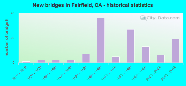
- New bridges - historical statistics
- 11910-1919
- 21920-1929
- 21930-1939
- 21940-1949
- 71950-1959
- 361960-1969
- 51970-1979
- 271980-1989
- 131990-1999
- 62000-2009
- 192010-2019

- Reconstructed bridges - Historical Statistics
- 11950-1959
- 21960-1969
- 31970-1979
- 01980-1989
- 21990-1999
- 62000-2009
- 22010-2019


- Bridge Condition - Deck
- 45.8%Good
- 12.5%Satisfactory
- 27.8%Fair
- 13.9%Poor

- Bridge Condition - Superstructure
- 66.2%Good
- 5.4%Satisfactory
- 21.6%Fair
- 6.8%Poor

- Bridge Condition - Substructure
- 93.2%Good
- 2.7%Satisfactory
- 4.1%Fair

- Bridge Condition - Channel
- 16.2%Excellent
- 44.1%Very good
- 27.9%Good
- 8.8%Satisfactory
- 2.9%Fair

- Bridge Condition - Culverts
- 47.6%Good
- 38.1%Satisfactory
- 9.5%Fair
- 4.8%Poor
Find on map >> Show street view
Structure Number: 23 0004, Location: 04-SOL-080-12.91-FRFD (Lat: 38.217258, Lng: -122.136631), Route carried "on" structure: Interstate 80, Year Built: 1928, Year Reconstructed: 2009, Status: Open, Structure Length: 2.44m (8.01ft), Average Daily Traffic: 189,000 (year 2009), Truck Traffic: 6%, Average Future Daily Traffic: 222,290 (year 2038), Design Load: H 15, Features Intersected: GREEN VALLEY CREEK
Minimum Vertical Clearance: 30+ m (98+ ft), Kilometerpoint: 12.910, Lanes on structure: 11, Base Highway Network: Yes (, Subroute: 2), Owner: State Highway Agency, Approaching Roadway Width: 46.2m (151.6ft), Skew: 39 degrees, Material/Design: Concrete continuous, Design/Construction: Slab, Number Of Spans In Main Unit: 3, Length of Maximum Span: 11.6m (38.1ft), Curb-To-Curb Width: 46.2m (151.6ft), Out-to-Out Width: 47.8m (156.8ft)
Condition: Deck: Poor, Superstructure: Poor, Substructure: Good, Channel: Very good, Operating Rating: 38.6 metric tons, Method Used To Determine Operating Rating: Load Factor (LF), Inventory Rating: 23.3 metric tons, Method Used To Determine Inventory Rating: Load Factor (LF), Structural Evaluation: Meets minimum limits, Deck Geometry: Equal to present minimum criteria, Waterway Adequacy: Somewhat better than minimum adequacy, Approach Roadway Alignment: Equal to present desirable criteria, Length Of Structure Improvement: 2.44m (8.01ft), Designated Inspection Frequency: Every 24 months, Inspection Date: Febuary 2021, Bridge Improvement Cost: $2,743,000, Roadway Improvement Cost: $548,000, Total Project Cost: $4,609,000 ( Estimate for 2020), Deck Structure Type: Concrete Cast-file-Place
Find on map >> Show street view
Structure Number: 23 0004G, Location: 04-SOL-680-13.12-FRFD (Lat: 38.217217, Lng: -122.136372), Route carried "on" structure: Ramp Interstate 680, Year Built: 1961, Status: Open, Structure Length: 2.44m (8.01ft), Average Daily Traffic: 32,500 (year 2003), Truck Traffic: 2%, Average Future Daily Traffic: 88,418 (year 2042), Design Load: HS 20, Features Intersected: GREEN VALLEY CREEK
Minimum Vertical Clearance: 30+ m (98+ ft), Kilometerpoint: 13.120, Lanes on structure: 3, Base Highway Network: Yes (Inventory Route: 6, Subroute: 1), Owner: State Highway Agency, Approaching Roadway Width: 16.5m (54.1ft), Skew: 3 degrees, Material/Design: Concrete continuous, Design/Construction: Slab, Number Of Spans In Main Unit: 3, Length of Maximum Span: 11.6m (38.1ft), Curb or Sidewalk Widths: Left: 0.6m (2.0ft), Right: 0.0m, Curb-To-Curb Width: 14.9m (48.9ft), Out-to-Out Width: 16.3m (53.5ft)
Condition: Deck: Good, Superstructure: Good, Substructure: Good, Channel: Good, Operating Rating: 57.3 metric tons, Method Used To Determine Operating Rating: Load and Resistance Factor Rating (LRFR) rating reported by rating factor(RF) method using HL-93 loadings, Inventory Rating: 44.4 metric tons, Method Used To Determine Inventory Rating: Load and Resistance Factor Rating (LRFR) rating reported by rating factor(RF) method using HL-93 loadings, Structural Evaluation: Better than present minimum criteria, Deck Geometry: Superior to present desirable criteria, Waterway Adequacy: Equal to present desirable criteria, Approach Roadway Alignment: Better than present minimum criteria, Designated Inspection Frequency: Every 24 months, Inspection Date: March 2020, Deck Structure Type: Concrete Cast-file-Place, Wearing Surface/Protective System: Wearing Surface: Integral Concrete
Find on map >> Show street view
Structure Number: 23 0006, Location: 04-SOL-080-13.92 (Lat: 38.226283, Lng: -122.122650), Route carried "on" structure: Interstate 80, Year Built: 1951, Year Reconstructed: 2004, Status: Open, Structure Length: 1.74m (5.71ft), Average Daily Traffic: 202,000 (year 2009), Truck Traffic: 10%, Average Future Daily Traffic: 305,169 (year 2038), Design Load: H 20, Features Intersected: DAN WILSON CREEK
Minimum Vertical Clearance: 30+ m (98+ ft), Kilometerpoint: 13.920, Lanes on structure: 12, Base Highway Network: Yes (, Subroute: 2), Owner: State Highway Agency, Approaching Roadway Width: 51.6m (169.3ft), Skew: 34 degrees, Material/Design: Concrete continuous, Design/Construction: Slab, Number Of Spans In Main Unit: 3, Length of Maximum Span: 5.9m (19.4ft), Curb-To-Curb Width: 51.6m (169.3ft), Out-to-Out Width: 51.6m (169.3ft)
Condition: Deck: Poor, Superstructure: Poor, Substructure: Good, Channel: Fair, Operating Rating: 26.9 metric tons, Method Used To Determine Operating Rating: Load and Resistance Factor Rating (LRFR) rating reported by rating factor(RF) method using HL-93 loadings, Inventory Rating: 20.7 metric tons, Method Used To Determine Inventory Rating: Load and Resistance Factor Rating (LRFR) rating reported by rating factor(RF) method using HL-93 loadings, Structural Evaluation: Meets minimum limits, Deck Geometry: Better than present minimum criteria, Waterway Adequacy: Somewhat better than minimum adequacy, Approach Roadway Alignment: Equal to present desirable criteria, Length Of Structure Improvement: 1.74m (5.71ft), Designated Inspection Frequency: Every 24 months, Inspection Date: Febuary 2021, Bridge Improvement Cost: $2,060,000, Roadway Improvement Cost: $412,000, Total Project Cost: $3,462,000 ( Estimate for 2017), Deck Structure Type: Concrete Cast-file-Place
Find on map >> Show street view
Structure Number: 23 0007, Location: 04-SOL-080-14.55 (Lat: 38.230814, Lng: -122.112528), Route carried "on" structure: Interstate 80, Year Built: 1932, Year Reconstructed: 1971, Status: Open, Structure Length: 2.19m (7.19ft), Average Daily Traffic: 202,000 (year 2009), Truck Traffic: 10%, Average Future Daily Traffic: 305,169 (year 2038), Design Load: H 15, Features Intersected: SUISUN CREEK
Minimum Vertical Clearance: 30+ m (98+ ft), Kilometerpoint: 14.550, Lanes on structure: 13, Base Highway Network: Yes (, Subroute: 2), Owner: State Highway Agency, Approaching Roadway Width: 56.2m (184.4ft), Skew: 31 degrees, Material/Design: Concrete, Design/Construction: Slab, Number Of Spans In Main Unit: 3, Length of Maximum Span: 7.3m (24.0ft), Curb-To-Curb Width: 56.2m (184.4ft), Out-to-Out Width: 57.6m (189.0ft)
Condition: Deck: Poor, Superstructure: Poor, Substructure: Good, Channel: Satisfactory, Operating Rating: 51.2 metric tons, Method Used To Determine Operating Rating: Load Factor (LF), Inventory Rating: 30.8 metric tons, Method Used To Determine Inventory Rating: Load Factor (LF), Structural Evaluation: Meets minimum limits, Deck Geometry: Superior to present desirable criteria, Waterway Adequacy: Meets minimum limits, Approach Roadway Alignment: Equal to present desirable criteria, Length Of Structure Improvement: 2.19m (7.19ft), Designated Inspection Frequency: Every 24 months, Inspection Date: Febuary 2021, Bridge Improvement Cost: $1,121,000, Roadway Improvement Cost: $224,000, Total Project Cost: $1,883,000 ( Estimate for 2020), Deck Structure Type: Concrete Cast-file-Place
Find on map >> Show street view
Structure Number: 23 0008L, Location: 04-SOL-080-17.02-FRFD (Lat: 38.248011, Lng: -122.072469), Route carried "on" structure: Interstate 80, Year Built: 1961, Year Reconstructed: 2009, Status: Open, Structure Length: 2.38m (7.81ft), Average Daily Traffic: 87,500 (year 2009), Truck Traffic: 6%, Average Future Daily Traffic: 137,751 (year 2038), Design Load: H 20, Features Intersected: LEDGEWOOD CREEK
Minimum Vertical Clearance: 30+ m (98+ ft), Kilometerpoint: 17.020, Lanes on structure: 6, Base Highway Network: Yes (, Subroute: 2), Owner: State Highway Agency, Approaching Roadway Width: 26.4m (86.6ft), Skew: 1 degrees, Material/Design: Concrete continuous, Design/Construction: Slab, Number Of Spans In Main Unit: 4, Length of Maximum Span: 6.6m (21.7ft), Curb-To-Curb Width: 26.4m (86.6ft), Out-to-Out Width: 27.2m (89.2ft)
Condition: Deck: Fair, Superstructure: Fair, Substructure: Good, Channel: Excellent, Operating Rating: 54.1 metric tons, Method Used To Determine Operating Rating: Load Factor (LF), Inventory Rating: 32.4 metric tons, Method Used To Determine Inventory Rating: Load Factor (LF), Structural Evaluation: Somewhat better than minimum adequacy, Deck Geometry: Meets minimum limits, Waterway Adequacy: Superior to present desirable criteria, Approach Roadway Alignment: Equal to present desirable criteria, Designated Inspection Frequency: Every 24 months, Inspection Date: January 2021, Deck Structure Type: Concrete Cast-file-Place
Find on map >> Show street view
Structure Number: 23 0008R, Location: 04-SOL-080-17.02-FRFD (Lat: 38.247761, Lng: -122.072375), Route carried "on" structure: Interstate 80, Year Built: 1949, Year Reconstructed: 2009, Status: Open, Structure Length: 2.42m (7.94ft), Average Daily Traffic: 87,500 (year 2009), Truck Traffic: 6%, Average Future Daily Traffic: 137,751 (year 2038), Design Load: H 20, Features Intersected: LEDGEWOOD CREEK
Minimum Vertical Clearance: 30+ m (98+ ft), Kilometerpoint: 17.020, Lanes on structure: 5, Base Highway Network: Yes (, Subroute: 2), Owner: State Highway Agency, Approaching Roadway Width: 26.7m (87.6ft), Skew: 1 degrees, Material/Design: Concrete continuous, Design/Construction: Slab, Number Of Spans In Main Unit: 4, Length of Maximum Span: 6.7m (22.0ft), Curb-To-Curb Width: 26.7m (87.6ft), Out-to-Out Width: 27.5m (90.2ft)
Condition: Deck: Fair, Superstructure: Fair, Substructure: Good, Channel: Very good, Operating Rating: 52.8 metric tons, Method Used To Determine Operating Rating: Load Factor (LF), Inventory Rating: 31.8 metric tons, Method Used To Determine Inventory Rating: Load Factor (LF), Structural Evaluation: Somewhat better than minimum adequacy, Deck Geometry: Superior to present desirable criteria, Waterway Adequacy: Equal to present desirable criteria, Approach Roadway Alignment: Equal to present desirable criteria, Designated Inspection Frequency: Every 24 months, Inspection Date: January 2021, Deck Structure Type: Concrete Cast-file-Place
Find on map >> Show street view
Structure Number: 23 0008S, Location: 04-SOL-080-17.02-FRFD (Lat: 38.247608, Lng: -122.072272), Route carried "on" structure: Ramp Interstate 80, Year Built: 1949, Status: Open, Structure Length: 2.43m (7.97ft), Average Daily Traffic: 4,622 (year 2003), Truck Traffic: 9%, Average Future Daily Traffic: 6,244 (year 2043), Design Load: H 20, Features Intersected: LEDGEWOOD CREEK
Minimum Vertical Clearance: 30+ m (98+ ft), Kilometerpoint: 17.020, Lanes on structure: 2, Base Highway Network: Yes (, Subroute: 1), Owner: State Highway Agency, Approaching Roadway Width: 10.5m (34.4ft), Material/Design: Concrete continuous, Design/Construction: Slab, Number Of Spans In Main Unit: 4, Length of Maximum Span: 6.7m (22.0ft), Curb-To-Curb Width: 10.5m (34.4ft), Out-to-Out Width: 11.6m (38.1ft)
Condition: Deck: Good, Superstructure: Good, Substructure: Good, Channel: Excellent, Operating Rating: 58.3 metric tons, Method Used To Determine Operating Rating: Load Factor (LF), Inventory Rating: 35.0 metric tons, Method Used To Determine Inventory Rating: Load Factor (LF), Structural Evaluation: Better than present minimum criteria, Deck Geometry: Better than present minimum criteria, Waterway Adequacy: Superior to present desirable criteria, Approach Roadway Alignment: Equal to present desirable criteria, Designated Inspection Frequency: Every 24 months, Inspection Date: January 2021, Deck Structure Type: Concrete Cast-file-Place, Wearing Surface/Protective System: Wearing Surface: Bituminous
Find on map >> Show street view
Structure Number: 23 0014L, Location: 04-SOL-080-R9.65 (Lat: 38.185456, Lng: -122.180506), Route carried "on" structure: Interstate 80, Year Built: 1969, Year Reconstructed: 2008, Status: Open, Structure Length: 5.81m (19.06ft), Average Daily Traffic: 57,000 (year 2009), Truck Traffic: 6%, Average Future Daily Traffic: 85,576 (year 2038), Design Load: HS 20+Mod, Features Intersected: LYNCH ROAD
Minimum Vertical Clearance: 30+ m (98+ ft), Kilometerpoint: 9.650, Lanes on structure: 4, Lanes under structure: 2, Base Highway Network: Yes (, Subroute: 2), Owner: State Highway Agency, Approaching Roadway Width: 20.7m (67.9ft), Material/Design: Concrete continuous, Design/Construction: Box Beam or Girders - Multiple, Number Of Spans In Main Unit: 3, Length of Maximum Span: 26.8m (87.9ft), Curb-To-Curb Width: 20.7m (67.9ft), Out-to-Out Width: 21.6m (70.9ft)
Condition: Deck: Satisfactory, Superstructure: Fair, Substructure: Good, Operating Rating: 39.5 metric tons, Method Used To Determine Operating Rating: Load and Resistance Factor Rating (LRFR) rating reported by rating factor(RF) method using HL-93 loadings, Inventory Rating: 30.5 metric tons, Method Used To Determine Inventory Rating: Load and Resistance Factor Rating (LRFR) rating reported by rating factor(RF) method using HL-93 loadings, Structural Evaluation: Somewhat better than minimum adequacy, Deck Geometry: Equal to present minimum criteria, Underclear: High priority of corrective action, Approach Roadway Alignment: Equal to present desirable criteria, Designated Inspection Frequency: Every 24 months, Inspection Date: Febuary 2021, Deck Structure Type: Concrete Cast-file-Place
Find on map >> Show street view
Structure Number: 23 0014R, Location: 04-SOL-080-R9.65 (Lat: 38.185122, Lng: -122.179925), Route carried "on" structure: Interstate 80, Year Built: 1969, Year Reconstructed: 2008, Status: Open, Structure Length: 2.68m (8.79ft), Average Daily Traffic: 57,000 (year 2009), Truck Traffic: 6%, Average Future Daily Traffic: 85,576 (year 2038), Design Load: HS 20+Mod, Features Intersected: LYNCH ROAD
Minimum Vertical Clearance: 30+ m (98+ ft), Kilometerpoint: 9.650, Lanes on structure: 4, Lanes under structure: 2, Base Highway Network: Yes (, Subroute: 2), Owner: State Highway Agency, Approaching Roadway Width: 20.7m (67.9ft), Material/Design: Prestressed concrete, Design/Construction: Box Beam or Girders - Multiple, Number Of Spans In Main Unit: 1, Length of Maximum Span: 26.1m (85.6ft), Curb-To-Curb Width: 20.7m (67.9ft), Out-to-Out Width: 21.6m (70.9ft)
Condition: Deck: Satisfactory, Superstructure: Fair, Substructure: Good, Operating Rating: 38.9 metric tons, Method Used To Determine Operating Rating: Load and Resistance Factor Rating (LRFR) rating reported by rating factor(RF) method using HL-93 loadings, Inventory Rating: 27.2 metric tons, Method Used To Determine Inventory Rating: Load and Resistance Factor Rating (LRFR) rating reported by rating factor(RF) method using HL-93 loadings, Structural Evaluation: Somewhat better than minimum adequacy, Deck Geometry: Equal to present minimum criteria, Underclear: High priority of corrective action, Approach Roadway Alignment: Equal to present desirable criteria, Designated Inspection Frequency: Every 24 months, Inspection Date: Febuary 2021, Deck Structure Type: Concrete Cast-file-Place
Find on map >> Show street view
Structure Number: 23 0016G, Location: 04-SOL-012-R2.76 (Lat: 38.208181, Lng: -122.150694), Route carried "on" structure: Ramp State highway 12, Year Built: 1968, Status: Open, Structure Length: 12.37m (40.58ft), Average Daily Traffic: 14,800 (year 2012), Truck Traffic: 7%, Average Future Daily Traffic: 23,359 (year 2042), Design Load: HS 20, Features Intersected: INTERSTATE 80
Minimum Vertical Clearance: 30+ m (98+ ft), Kilometerpoint: 2.760, Lanes on structure: 1, Lanes under structure: 8, Owner: State Highway Agency, Approaching Roadway Width: 7.9m (25.9ft), Skew: 4 degrees, Material/Design: Prestressed concrete continuous, Design/Construction: Box Beam or Girders - Multiple, Number Of Spans In Main Unit: 2, Length of Maximum Span: 59.4m (194.9ft), Curb-To-Curb Width: 7.3m (24.0ft), Out-to-Out Width: 7.9m (25.9ft)
Condition: Deck: Fair, Superstructure: Good, Substructure: Fair, Operating Rating: 99.8 metric tons, Method Used To Determine Operating Rating: Load Factor (LF), Inventory Rating: 32.4 metric tons, Method Used To Determine Inventory Rating: Load Factor (LF), Structural Evaluation: Somewhat better than minimum adequacy, Deck Geometry: Better than present minimum criteria, Underclear: Meets minimum limits, Approach Roadway Alignment: Equal to present desirable criteria, Designated Inspection Frequency: Every 24 months, Inspection Date: March 2020, Deck Structure Type: Concrete Cast-file-Place
Find on map >> Show street view
Structure Number: 23 002, Location: 04-SOL-012-R14.68 (Lat: 38.207467, Lng: -121.876583), Route carried "on" structure: State highway 12, Year Built: 1993, Status: Open, Structure Length: 5.82m (19.09ft), Average Daily Traffic: 12,200 (year 2009), Average Future Daily Traffic: 19,735 (year 2040), Design Load: HS 20+Mod, Features Intersected: UP RR
Minimum Vertical Clearance: 30+ m (98+ ft), Kilometerpoint: 14.680, Lanes on structure: 2, Base Highway Network: Yes (, Subroute: 1), Owner: State Highway Agency, Approaching Roadway Width: 12.2m (40.0ft), Skew: 4 degrees, Material/Design: Prestressed concrete continuous, Design/Construction: Box Beam or Girders - Multiple, Number Of Spans In Main Unit: 2, Length of Maximum Span: 34.1m (111.9ft), Curb-To-Curb Width: 12.2m (40.0ft), Out-to-Out Width: 13.3m (43.6ft)
Condition: Deck: Fair, Superstructure: Good, Substructure: Good, Operating Rating: 54.1 metric tons, Method Used To Determine Operating Rating: Assigned rating based on Load Factor Design (LFD) reported in metric tons, Inventory Rating: 32.4 metric tons, Method Used To Determine Inventory Rating: Assigned rating based on Load Factor Design (LFD) reported in metric tons, Structural Evaluation: Better than present minimum criteria, Deck Geometry: Somewhat better than minimum adequacy, Underclear: Equal to present minimum criteria, Approach Roadway Alignment: Equal to present minimum criteria, Designated Inspection Frequency: Every 24 months, Inspection Date: March 2020, Deck Structure Type: Concrete Cast-file-Place
Find on map >> Show street view
Structure Number: 23 0061R, Location: 04-SOL-080-17.92-FRFD (Lat: 38.258203, Lng: -122.063125), Route carried "on" structure: City street , Year Built: 1963, Status: Open, Structure Length: 10.12m (33.20ft), Average Daily Traffic: 10,978 (year 1998), Truck Traffic: 7%, Average Future Daily Traffic: 15,246 (year 2043), Design Load: H 20, Features Intersected: INTERSTATE 80 & RAMPS, Facility Carried by Structure: EB TRAVIS BLVD
Minimum Vertical Clearance: 30+ m (98+ ft), Kilometerpoint: 0.000, Lanes on structure: 2, Lanes under structure: 12, Base Highway Network: Yes, Owner: State Highway Agency, Approaching Roadway Width: 9.8m (32.2ft), Skew: 3 degrees, Material/Design: Steel, Design/Construction: Stringer/Multi-beam, Number Of Spans In Main Unit: 4, Length of Maximum Span: 37.8m (124.0ft), Curb or Sidewalk Widths: Left: 0.0m, Right: 1.5m (4.9ft), Curb-To-Curb Width: 9.8m (32.2ft), Out-to-Out Width: 12.2m (40.0ft)
Condition: Deck: Satisfactory, Superstructure: Good, Substructure: Good, Operating Rating: 49.9 metric tons, Method Used To Determine Operating Rating: Load and Resistance Factor Rating (LRFR) rating reported by rating factor(RF) method using HL-93 loadings, Inventory Rating: 38.6 metric tons, Method Used To Determine Inventory Rating: Load and Resistance Factor Rating (LRFR) rating reported by rating factor(RF) method using HL-93 loadings, Structural Evaluation: Better than present minimum criteria, Deck Geometry: Meets minimum limits, Underclear: Meets minimum limits, Approach Roadway Alignment: Equal to present desirable criteria, Designated Inspection Frequency: Every 24 months, Other Special Inspection Frequency: Every 48 months, Inspection Date: January 2021, Other Special Inspection Date: January 2022, Deck Structure Type: Concrete Cast-file-Place
Find on map >> Show street view
Structure Number: 23 0096, Location: 04-SOL-080-19.18-FRFD (Lat: 38.273303, Lng: -122.050347), Route carried "on" structure: County highway , Year Built: 1989, Status: Open, Structure Length: 8.38m (27.49ft), Average Daily Traffic: 41,194 (year 2001), Truck Traffic: 5%, Average Future Daily Traffic: 47,477 (year 2038), Design Load: HS 20, Features Intersected: INTERSTATE 80 & RAMP, Facility Carried by Structure: AIR BASE PARKWAY
Minimum Vertical Clearance: 30+ m (98+ ft), Kilometerpoint: 0.000, Lanes on structure: 5, Lanes under structure: 9, Base Highway Network: Yes, Owner: State Highway Agency, Approaching Roadway Width: 28.0m (91.9ft), Skew: 2 degrees, Material/Design: Prestressed concrete continuous, Design/Construction: Box Beam or Girders - Multiple, Number Of Spans In Main Unit: 2, Length of Maximum Span: 46.1m (151.2ft), Curb or Sidewalk Widths: Left: 1.5m (4.9ft), Right: 1.5m (4.9ft), Curb-To-Curb Width: 26.8m (87.9ft), Out-to-Out Width: 30.5m (100.1ft)
Condition: Deck: Fair, Superstructure: Good, Substructure: Good, Operating Rating: 54.1 metric tons, Method Used To Determine Operating Rating: Assigned rating based on Load Factor Design (LFD) reported in metric tons, Inventory Rating: 32.4 metric tons, Method Used To Determine Inventory Rating: Assigned rating based on Load Factor Design (LFD) reported in metric tons, Structural Evaluation: Better than present minimum criteria, Deck Geometry: Superior to present desirable criteria, Underclear: High priority of corrective action, Approach Roadway Alignment: Equal to present desirable criteria, Designated Inspection Frequency: Every 24 months, Inspection Date: January 2021, Deck Structure Type: Concrete Cast-file-Place
Find on map >> Show street view
Structure Number: 23 0106L, Location: 04-SOL-080-17.20-FRFD (Lat: 38.249525, Lng: -122.070067), Route carried "on" structure: Interstate 80, Year Built: 1961, Year Reconstructed: 2010, Status: Open, Structure Length: 6.61m (21.69ft), Average Daily Traffic: 87,500 (year 2009), Truck Traffic: 6%, Average Future Daily Traffic: 137,751 (year 2038), Design Load: HS 20+Mod, Features Intersected: WEST TEXAS STREET
Minimum Vertical Clearance: 30+ m (98+ ft), Kilometerpoint: 17.200, Lanes on structure: 5, Lanes under structure: 5, Base Highway Network: Yes (, Subroute: 2), Owner: State Highway Agency, Approaching Roadway Width: 21.3m (69.9ft), Skew: 9 degrees, Material/Design: Concrete continuous, Design/Construction: Box Beam or Girders - Multiple, Number Of Spans In Main Unit: 3, Length of Maximum Span: 30.2m (99.1ft), Curb-To-Curb Width: 21.3m (69.9ft), Out-to-Out Width: 22.1m (72.5ft)
Condition: Deck: Poor, Superstructure: Fair, Substructure: Good, Operating Rating: 54.1 metric tons, Method Used To Determine Operating Rating: Field evaluation and documented engineering judgment, Inventory Rating: 32.4 metric tons, Method Used To Determine Inventory Rating: Field evaluation and documented engineering judgment, Structural Evaluation: Somewhat better than minimum adequacy, Deck Geometry: Meets minimum limits, Underclear: High priority of corrective action, Approach Roadway Alignment: Equal to present desirable criteria, Length Of Structure Improvement: 6.61m (21.69ft), Designated Inspection Frequency: Every 24 months, Inspection Date: January 2021, Bridge Improvement Cost: $1,461,000, Roadway Improvement Cost: $292,000, Total Project Cost: $2,454,000 ( Estimate for 2021), Deck Structure Type: Concrete Cast-file-Place
Find on map >> Show street view
Structure Number: 23 0106R, Location: 04-SOL-080-17.20-FRFD (Lat: 38.249558, Lng: -122.069664), Route carried "on" structure: Interstate 80, Year Built: 1961, Year Reconstructed: 2010, Status: Open, Structure Length: 6.08m (19.95ft), Average Daily Traffic: 87,500 (year 2009), Truck Traffic: 6%, Average Future Daily Traffic: 137,751 (year 2038), Design Load: HS 20+Mod, Features Intersected: WEST TEXAS STREET
Minimum Vertical Clearance: 30+ m (98+ ft), Kilometerpoint: 17.200, Lanes on structure: 5, Lanes under structure: 4, Base Highway Network: Yes (, Subroute: 2), Owner: State Highway Agency, Approaching Roadway Width: 23.5m (77.1ft), Skew: 4 degrees, Material/Design: Concrete continuous, Design/Construction: Box Beam or Girders - Multiple, Number Of Spans In Main Unit: 3, Length of Maximum Span: 27.8m (91.2ft), Curb-To-Curb Width: 23.5m (77.1ft), Out-to-Out Width: 24.4m (80.1ft)
Condition: Deck: Poor, Superstructure: Fair, Substructure: Good, Operating Rating: 54.1 metric tons, Method Used To Determine Operating Rating: Field evaluation and documented engineering judgment, Inventory Rating: 32.4 metric tons, Method Used To Determine Inventory Rating: Field evaluation and documented engineering judgment, Structural Evaluation: Somewhat better than minimum adequacy, Deck Geometry: Equal to present minimum criteria, Underclear: High priority of corrective action, Approach Roadway Alignment: Equal to present desirable criteria, Length Of Structure Improvement: 6.08m (19.95ft), Designated Inspection Frequency: Every 24 months, Inspection Date: January 2021, Bridge Improvement Cost: $1,531,000, Roadway Improvement Cost: $306,000, Total Project Cost: $2,572,000 ( Estimate for 2019), Deck Structure Type: Concrete Cast-file-Place
Find on map >> Show street view
Structure Number: 23 0131L, Location: 04-SOL-780-2.96-BEN (Lat: 38.064603, Lng: -122.164289), Route carried "on" structure: Interstate 780, Year Built: 1962, Year Reconstructed: 1977, Status: Open, Structure Length: 3.79m (12.43ft), Average Daily Traffic: 23,500 (year 2009), Truck Traffic: 5%, Average Future Daily Traffic: 40,202 (year 2040), Design Load: HS 20+Mod, Features Intersected: WEST 7TH STREET
Minimum Vertical Clearance: 30+ m (98+ ft), Kilometerpoint: 2.960, Lanes on structure: 3, Lanes under structure: 2, Base Highway Network: Yes (Inventory Route: 7, Subroute: 1), Owner: State Highway Agency, Approaching Roadway Width: 15.5m (50.9ft), Material/Design: Concrete continuous, Design/Construction: Tee Beam, Number Of Spans In Main Unit: 3, Length of Maximum Span: 19.2m (63.0ft), Curb-To-Curb Width: 15.5m (50.9ft), Out-to-Out Width: 16.5m (54.1ft)
Condition: Deck: Good, Superstructure: Good, Substructure: Good, Operating Rating: 31.4 metric tons, Method Used To Determine Operating Rating: Load and Resistance Factor Rating (LRFR) rating reported by rating factor(RF) method using HL-93 loadings, Inventory Rating: 24.3 metric tons, Method Used To Determine Inventory Rating: Load and Resistance Factor Rating (LRFR) rating reported by rating factor(RF) method using HL-93 loadings, Structural Evaluation: Equal to present minimum criteria, Deck Geometry: Somewhat better than minimum adequacy, Underclear: Somewhat better than minimum adequacy, Approach Roadway Alignment: Equal to present desirable criteria, Designated Inspection Frequency: Every 24 months, Inspection Date: January 2022, Deck Structure Type: Concrete Cast-file-Place, Wearing Surface/Protective System: Wearing Surface: Bituminous
Find on map >> Show street view
Structure Number: 23 0135E, Location: 04-SOL-080-12.90-FRFD (Lat: 38.217481, Lng: -122.137553), Route carried "on" structure: Ramp Interstate 80, Year Built: 1961, Status: Open, Structure Length: 4.39m (14.40ft), Average Daily Traffic: 33,700 (year 2003), Truck Traffic: 2%, Average Future Daily Traffic: 61,580 (year 2041), Design Load: H 20, Features Intersected: GREEN VALLEY CREEK
Minimum Vertical Clearance: 30+ m (98+ ft), Kilometerpoint: 12.900, Lanes on structure: 3, Base Highway Network: Yes (, Subroute: 1), Owner: State Highway Agency, Approaching Roadway Width: 20.4m (66.9ft), Skew: 30 degrees, Material/Design: Concrete continuous, Design/Construction: Slab, Number Of Spans In Main Unit: 6, Length of Maximum Span: 7.9m (25.9ft), Curb-To-Curb Width: 18.0m (59.1ft), Out-to-Out Width: 19.4m (63.6ft)
Condition: Deck: Poor, Superstructure: Poor, Substructure: Good, Channel: Very good, Operating Rating: 66.1 metric tons, Method Used To Determine Operating Rating: Load Factor (LF), Inventory Rating: 39.9 metric tons, Method Used To Determine Inventory Rating: Load Factor (LF), Structural Evaluation: Meets minimum limits, Deck Geometry: Superior to present desirable criteria, Waterway Adequacy: Superior to present desirable criteria, Approach Roadway Alignment: Equal to present desirable criteria, Length Of Structure Improvement: 4.39m (14.40ft), Designated Inspection Frequency: Every 24 months, Inspection Date: Febuary 2021, Bridge Improvement Cost: $852,000, Roadway Improvement Cost: $170,000, Total Project Cost: $1,431,000 ( Estimate for 2020), Deck Structure Type: Concrete Cast-file-Place
Find on map >> Show street view
Structure Number: 23 0136, Location: 04-SOL-012-12.92 (Lat: 38.227489, Lng: -121.896114), Route carried "on" structure: State highway 12, Year Built: 1957, Status: Open, Structure Length: 1.75m (5.74ft), Average Daily Traffic: 12,200 (year 2009), Average Future Daily Traffic: 19,735 (year 2040), Design Load: HS 20, Features Intersected: DENVERTON CREEK
Minimum Vertical Clearance: 30+ m (98+ ft), Kilometerpoint: 12.920, Lanes on structure: 2, Base Highway Network: Yes (, Subroute: 1), Owner: State Highway Agency, Approaching Roadway Width: 12.2m (40.0ft), Skew: 30 degrees, Material/Design: Concrete continuous, Design/Construction: Slab, Number Of Spans In Main Unit: 3, Length of Maximum Span: 6.7m (22.0ft), Curb-To-Curb Width: 12.2m (40.0ft), Out-to-Out Width: 12.3m (40.4ft)
Condition: Deck: Satisfactory, Superstructure: Satisfactory, Substructure: Good, Channel: Good, Operating Rating: 36.6 metric tons, Method Used To Determine Operating Rating: Load and Resistance Factor Rating (LRFR) rating reported by rating factor(RF) method using HL-93 loadings, Inventory Rating: 28.2 metric tons, Method Used To Determine Inventory Rating: Load and Resistance Factor Rating (LRFR) rating reported by rating factor(RF) method using HL-93 loadings, Structural Evaluation: Equal to present minimum criteria, Deck Geometry: Somewhat better than minimum adequacy, Waterway Adequacy: Equal to present desirable criteria, Approach Roadway Alignment: Equal to present desirable criteria, Designated Inspection Frequency: Every 24 months, Inspection Date: March 2020, Deck Structure Type: Concrete Cast-file-Place, Wearing Surface/Protective System: Wearing Surface: Bituminous
Find on map >> Show street view
Structure Number: 23 0139E, Location: 04-SOL-680-13.09-FRFD (Lat: 38.216189, Lng: -122.137769), Route carried "on" structure: Ramp Interstate 680, Year Built: 1961, Status: Open, Structure Length: 11.75m (38.55ft), Average Daily Traffic: 60,000 (year 2008), Truck Traffic: 5%, Average Future Daily Traffic: 131,570 (year 2042), Design Load: HS 20, Features Intersected: I 80 & GREEN VALLEY-E80
Minimum Vertical Clearance: 30+ m (98+ ft), Kilometerpoint: 13.090, Lanes on structure: 3, Lanes under structure: 11, Base Highway Network: Yes (Inventory Route: 6, Subroute: 1), Owner: State Highway Agency, Approaching Roadway Width: 17.2m (56.4ft), Skew: 34 degrees, Material/Design: Steel, Design/Construction: Stringer/Multi-beam, Number Of Spans In Main Unit: 4, Length of Maximum Span: 36.6m (120.1ft), Curb-To-Curb Width: 17.2m (56.4ft), Out-to-Out Width: 18.7m (61.4ft)
Condition: Deck: Poor, Superstructure: Good, Substructure: Good, Operating Rating: 65.4 metric tons, Method Used To Determine Operating Rating: Load Factor (LF), Inventory Rating: 39.2 metric tons, Method Used To Determine Inventory Rating: Load Factor (LF), Structural Evaluation: Better than present minimum criteria, Deck Geometry: Superior to present desirable criteria, Underclear: Somewhat better than minimum adequacy, Approach Roadway Alignment: Equal to present desirable criteria, Designated Inspection Frequency: Every 24 months, Other Special Inspection Frequency: Every 48 months, Inspection Date: March 2020, Other Special Inspection Date: January 2022, Deck Structure Type: Concrete Cast-file-Place
Find on map >> Show street view
Structure Number: 23 0141, Location: 04-SOL-080-16.17 (Lat: 38.242522, Lng: -122.087175), Route carried "on" structure: County highway , Year Built: 1987, Status: Open, Structure Length: 7.17m (23.52ft), Average Daily Traffic: 1,550 (year 1998), Truck Traffic: 2%, Average Future Daily Traffic: 3,272 (year 2041), Design Load: HS 20+Mod, Features Intersected: INTERSTATE 80, Facility Carried by Structure: ABERNATHY ROAD
Minimum Vertical Clearance: 30+ m (98+ ft), Kilometerpoint: 0.000, Lanes on structure: 4, Lanes under structure: 10, Owner: State Highway Agency, Approaching Roadway Width: 23.2m (76.1ft), Skew: 2 degrees, Material/Design: Prestressed concrete continuous, Design/Construction: Box Beam or Girders - Multiple, Number Of Spans In Main Unit: 2, Length of Maximum Span: 35.4m (116.1ft), Curb-To-Curb Width: 23.2m (76.1ft), Out-to-Out Width: 24.3m (79.7ft)
Condition: Deck: Fair, Superstructure: Good, Substructure: Good, Operating Rating: 48.6 metric tons, Method Used To Determine Operating Rating: Load and Resistance Factor Rating (LRFR) rating reported by rating factor(RF) method using HL-93 loadings, Inventory Rating: 34.0 metric tons, Method Used To Determine Inventory Rating: Load and Resistance Factor Rating (LRFR) rating reported by rating factor(RF) method using HL-93 loadings, Structural Evaluation: Better than present minimum criteria, Deck Geometry: Superior to present desirable criteria, Underclear: Equal to present minimum criteria, Approach Roadway Alignment: Equal to present desirable criteria, Designated Inspection Frequency: Every 24 months, Inspection Date: Febuary 2021, Deck Structure Type: Concrete Cast-file-Place
Find on map >> Show street view
Structure Number: 23 0142L, Location: 04-SOL-680-12.63-FRFD (Lat: 38.209475, Lng: -122.137892), Route carried "on" structure: Interstate 680, Year Built: 1961, Status: Open, Structure Length: 9.45m (31.00ft), Average Daily Traffic: 31,000 (year 2009), Truck Traffic: 5%, Average Future Daily Traffic: 41,717 (year 2040), Design Load: HS 20, Features Intersected: NVRR,CORDELIA RD,BRIDGE
Minimum Vertical Clearance: 30+ m (98+ ft), Kilometerpoint: 12.630, Lanes on structure: 2, Lanes under structure: 2, Base Highway Network: Yes (Inventory Route: 6, Subroute: 1), Owner: State Highway Agency, Approaching Roadway Width: 11.3m (37.1ft), Skew: 1 degrees, Material/Design: Concrete continuous, Design/Construction: Tee Beam, Number Of Spans In Main Unit: 5, Length of Maximum Span: 22.3m (73.2ft), Curb-To-Curb Width: 11.3m (37.1ft), Out-to-Out Width: 12.1m (39.7ft)
Condition: Deck: Poor, Superstructure: Good, Substructure: Good, Operating Rating: 41.1 metric tons, Method Used To Determine Operating Rating: Load and Resistance Factor Rating (LRFR) rating reported by rating factor(RF) method using HL-93 loadings, Inventory Rating: 31.8 metric tons, Method Used To Determine Inventory Rating: Load and Resistance Factor Rating (LRFR) rating reported by rating factor(RF) method using HL-93 loadings, Structural Evaluation: Better than present minimum criteria, Deck Geometry: Somewhat better than minimum adequacy, Underclear: High priority of corrective action, Approach Roadway Alignment: Equal to present desirable criteria, Length Of Structure Improvement: 9.45m (31.00ft), Designated Inspection Frequency: Every 24 months, Inspection Date: March 2020, Bridge Improvement Cost: $1,158,000, Roadway Improvement Cost: $231,000, Total Project Cost: $1,945,000 ( Estimate for 2021), Deck Structure Type: Concrete Cast-file-Place
Find on map >> Show street view
Structure Number: 23 0142R, Location: 04-SOL-680-12.63-FRFD (Lat: 38.209519, Lng: -122.137639), Route carried "on" structure: Interstate 680, Year Built: 1961, Status: Open, Structure Length: 9.45m (31.00ft), Average Daily Traffic: 31,000 (year 2009), Truck Traffic: 5%, Average Future Daily Traffic: 41,717 (year 2040), Design Load: HS 20, Features Intersected: NVRR,CORDELIA RD,BRIDGE
Minimum Vertical Clearance: 30+ m (98+ ft), Kilometerpoint: 12.630, Lanes on structure: 2, Lanes under structure: 4, Base Highway Network: Yes (Inventory Route: 6, Subroute: 1), Owner: State Highway Agency, Approaching Roadway Width: 10.7m (35.1ft), Skew: 1 degrees, Material/Design: Concrete continuous, Design/Construction: Tee Beam, Number Of Spans In Main Unit: 5, Length of Maximum Span: 22.3m (73.2ft), Curb-To-Curb Width: 11.3m (37.1ft), Out-to-Out Width: 12.1m (39.7ft)
Condition: Deck: Poor, Superstructure: Good, Substructure: Good, Operating Rating: 41.1 metric tons, Method Used To Determine Operating Rating: Load and Resistance Factor Rating (LRFR) rating reported by rating factor(RF) method using HL-93 loadings, Inventory Rating: 31.8 metric tons, Method Used To Determine Inventory Rating: Load and Resistance Factor Rating (LRFR) rating reported by rating factor(RF) method using HL-93 loadings, Structural Evaluation: Better than present minimum criteria, Deck Geometry: Somewhat better than minimum adequacy, Underclear: Somewhat better than minimum adequacy, Approach Roadway Alignment: Equal to present desirable criteria, Length Of Structure Improvement: 9.45m (31.00ft), Designated Inspection Frequency: Every 24 months, Inspection Date: March 2020, Bridge Improvement Cost: $1,158,000, Roadway Improvement Cost: $231,000, Total Project Cost: $1,945,000 ( Estimate for 2021), Deck Structure Type: Concrete Cast-file-Place
Find on map >> Show street view
Structure Number: 23 0162, Location: 04-SOL-680-R7.32 (Lat: 38.148408, Lng: -122.111514), Route carried "on" structure: County highway , Year Built: 1966, Status: Open, Structure Length: 5.18m (16.99ft), Average Daily Traffic: 1,000 (year 1998), Truck Traffic: 5%, Average Future Daily Traffic: 1,409 (year 2042), Design Load: HS 20, Features Intersected: INTERSTATE 680, Facility Carried by Structure: MARSHVIEW ROAD
Minimum Vertical Clearance: 30+ m (98+ ft), Kilometerpoint: 0.000, Lanes on structure: 2, Lanes under structure: 4, Owner: State Highway Agency, Approaching Roadway Width: 8.8m (28.9ft), Material/Design: Concrete continuous, Design/Construction: Box Beam or Girders - Multiple, Number Of Spans In Main Unit: 2, Length of Maximum Span: 25.9m (85.0ft), Curb or Sidewalk Widths: Left: 0.6m (2.0ft), Right: 0.6m (2.0ft), Curb-To-Curb Width: 8.5m (27.9ft), Out-to-Out Width: 10.4m (34.1ft)
Condition: Deck: Satisfactory, Superstructure: Fair, Substructure: Good, Operating Rating: 40.5 metric tons, Method Used To Determine Operating Rating: Load and Resistance Factor Rating (LRFR) rating reported by rating factor(RF) method using HL-93 loadings, Inventory Rating: 31.4 metric tons, Method Used To Determine Inventory Rating: Load and Resistance Factor Rating (LRFR) rating reported by rating factor(RF) method using HL-93 loadings, Structural Evaluation: Somewhat better than minimum adequacy, Deck Geometry: Somewhat better than minimum adequacy, Underclear: Somewhat better than minimum adequacy, Approach Roadway Alignment: Equal to present desirable criteria, Designated Inspection Frequency: Every 24 months, Inspection Date: March 2020, Deck Structure Type: Concrete Cast-file-Place
Find on map >> Show street view
Structure Number: 23 0163, Location: 04-SOL-680-R10.02-FRFD (Lat: 38.182650, Lng: -122.134542), Route carried "on" structure: County highway , Year Built: 1966, Status: Open, Structure Length: 5.18m (16.99ft), Average Daily Traffic: 2,000 (year 1998), Truck Traffic: 5%, Average Future Daily Traffic: 2,708 (year 2042), Design Load: HS 20, Features Intersected: INTERSTATE 680, Facility Carried by Structure: GOLD HILL ROAD
Minimum Vertical Clearance: 30+ m (98+ ft), Kilometerpoint: 0.000, Lanes on structure: 2, Lanes under structure: 4, Owner: State Highway Agency, Approaching Roadway Width: 14.0m (45.9ft), Material/Design: Concrete continuous, Design/Construction: Box Beam or Girders - Multiple, Number Of Spans In Main Unit: 2, Length of Maximum Span: 25.6m (84.0ft), Curb or Sidewalk Widths: Left: 0.6m (2.0ft), Right: 0.6m (2.0ft), Curb-To-Curb Width: 8.5m (27.9ft), Out-to-Out Width: 10.4m (34.1ft)
Condition: Deck: Fair, Superstructure: Good, Substructure: Good, Operating Rating: 40.8 metric tons, Method Used To Determine Operating Rating: Load and Resistance Factor Rating (LRFR) rating reported by rating factor(RF) method using HL-93 loadings, Inventory Rating: 31.4 metric tons, Method Used To Determine Inventory Rating: Load and Resistance Factor Rating (LRFR) rating reported by rating factor(RF) method using HL-93 loadings, Structural Evaluation: Better than present minimum criteria, Deck Geometry: Somewhat better than minimum adequacy, Underclear: High priority of corrective action, Approach Roadway Alignment: Equal to present desirable criteria, Designated Inspection Frequency: Every 24 months, Inspection Date: March 2020, Deck Structure Type: Concrete Cast-file-Place
Find on map >> Show street view
Structure Number: 23 0165, Location: 04-SOL-080-R11.39-FRFD (Lat: 38.201842, Lng: -122.156992), Route carried "on" structure: Interstate 80, Year Built: 1969, Status: Open, Structure Length: 2.58m (8.46ft), Average Daily Traffic: 115,000 (year 2009), Truck Traffic: 5%, Average Future Daily Traffic: 173,019 (year 2038), Design Load: H 20, Features Intersected: RED TOP ROAD
Minimum Vertical Clearance: 30+ m (98+ ft), Kilometerpoint: 11.390, Lanes on structure: 8, Lanes under structure: 2, Base Highway Network: Yes (, Subroute: 2), Owner: State Highway Agency, Approaching Roadway Width: 46.0m (150.9ft), Skew: 30 degrees, Material/Design: Prestressed concrete, Design/Construction: Box Beam or Girders - Multiple, Number Of Spans In Main Unit: 1, Length of Maximum Span: 25.2m (82.7ft), Curb-To-Curb Width: 46.0m (150.9ft), Out-to-Out Width: 47.5m (155.8ft)
Condition: Deck: Satisfactory, Superstructure: Good, Substructure: Good, Operating Rating: 39.5 metric tons, Method Used To Determine Operating Rating: Load and Resistance Factor Rating (LRFR) rating reported by rating factor(RF) method using HL-93 loadings, Inventory Rating: 27.2 metric tons, Method Used To Determine Inventory Rating: Load and Resistance Factor Rating (LRFR) rating reported by rating factor(RF) method using HL-93 loadings, Structural Evaluation: Equal to present minimum criteria, Deck Geometry: Superior to present desirable criteria, Underclear: Meets minimum limits, Approach Roadway Alignment: Equal to present desirable criteria, Designated Inspection Frequency: Every 24 months, Inspection Date: Febuary 2021, Deck Structure Type: Concrete Cast-file-Place
Find on map >> Show street view
Structure Number: 23 0166, Location: 04-SOL-680-R10.67-FRFD (Lat: 38.191633, Lng: -122.137444), Route carried "on" structure: Interstate 680, Year Built: 1966, Status: Open, Structure Length: 0.79m (2.59ft), Average Daily Traffic: 62,000 (year 2009), Truck Traffic: 5%, Average Future Daily Traffic: 83,432 (year 2040), Features Intersected: AMERICAN CANYON CREEK
Minimum Vertical Clearance: 30+ m (98+ ft), Kilometerpoint: 10.670, Lanes on structure: 4, Base Highway Network: Yes (Inventory Route: 6, Subroute: 1), Owner: State Highway Agency, Approaching Roadway Width: 11.3m (37.1ft), Skew: 20 degrees, Material/Design: Concrete continuous, Design/Construction: Culvert, Number Of Spans In Main Unit: 2, Length of Maximum Span: 3.7m (12.1ft)
Condition: Channel: Good, Culverts: Good, Operating Rating: 54.1 metric tons, Method Used To Determine Operating Rating: Field evaluation and documented engineering judgment, Inventory Rating: 32.4 metric tons, Method Used To Determine Inventory Rating: Field evaluation and documented engineering judgment, Structural Evaluation: Better than present minimum criteria, Waterway Adequacy: Better than present minimum criteria, Approach Roadway Alignment: Equal to present desirable criteria, Designated Inspection Frequency: Every 24 months, Inspection Date: March 2020
Find on map >> Show street view
Structure Number: 23 0199F, Location: 04-SOL-012-L1.81 (Lat: 38.239931, Lng: -122.093125), Route carried "on" structure: Ramp State highway 12, Year Built: 1987, Status: Open, Structure Length: 17.04m (55.91ft), Average Daily Traffic: 17,200 (year 2009), Truck Traffic: 2%, Average Future Daily Traffic: 23,359 (year 2042), Design Load: HS 20+Mod, Features Intersected: INTERSTATE 80
Minimum Vertical Clearance: 30+ m (98+ ft), Kilometerpoint: 1.810, Lanes on structure: 2, Lanes under structure: 10, Owner: State Highway Agency, Approaching Roadway Width: 13.7m (44.9ft), Material/Design: Prestressed concrete continuous, Design/Construction: Box Beam or Girders - Multiple, Number Of Spans In Main Unit: 3, Number Of Approach Spans: 1, Length of Maximum Span: 62.5m (205.1ft), Curb-To-Curb Width: 11.7m (38.4ft), Out-to-Out Width: 12.8m (42.0ft)
Condition: Deck: Satisfactory, Superstructure: Good, Substructure: Good, Operating Rating: 54.1 metric tons, Method Used To Determine Operating Rating: Assigned rating based on Load Factor Design (LFD) reported in metric tons, Inventory Rating: 32.4 metric tons, Method Used To Determine Inventory Rating: Assigned rating based on Load Factor Design (LFD) reported in metric tons, Structural Evaluation: Better than present minimum criteria, Deck Geometry: Superior to present desirable criteria, Underclear: Equal to present minimum criteria, Approach Roadway Alignment: Equal to present desirable criteria, Designated Inspection Frequency: Every 24 months, Inspection Date: March 2020, Deck Structure Type: Concrete Cast-file-Place
Find on map >> Show street view
Structure Number: 23 02, Location: 04-SOL-012-L2.22 (Lat: 38.239628, Lng: -122.084369), Route carried "on" structure: State highway 12, Year Built: 1987, Status: Open, Structure Length: 4.24m (13.91ft), Average Daily Traffic: 40,500 (year 2009), Truck Traffic: 7%, Average Future Daily Traffic: 45,528 (year 2040), Design Load: HS 20+Mod, Features Intersected: CHADBOURNE ROAD
Minimum Vertical Clearance: 30+ m (98+ ft), Kilometerpoint: 2.220, Lanes on structure: 4, Lanes under structure: 4, Base Highway Network: Yes (, Subroute: 1), Owner: State Highway Agency, Approaching Roadway Width: 30.5m (100.1ft), Skew: 30 degrees, Material/Design: Prestressed concrete, Design/Construction: Box Beam or Girders - Multiple, Number Of Spans In Main Unit: 1, Length of Maximum Span: 41.5m (136.2ft), Curb or Sidewalk Widths: Left: 0.5m (1.6ft), Right: 0.5m (1.6ft), Curb-To-Curb Width: 29.4m (96.5ft), Out-to-Out Width: 30.5m (100.1ft)
Condition: Deck: Good, Superstructure: Good, Substructure: Good, Operating Rating: 54.1 metric tons, Method Used To Determine Operating Rating: Assigned rating based on Load Factor Design (LFD) reported in metric tons, Inventory Rating: 32.4 metric tons, Method Used To Determine Inventory Rating: Assigned rating based on Load Factor Design (LFD) reported in metric tons, Structural Evaluation: Better than present minimum criteria, Deck Geometry: Superior to present desirable criteria, Underclear: Meets minimum limits, Approach Roadway Alignment: Equal to present desirable criteria, Designated Inspection Frequency: Every 24 months, Inspection Date: March 2020, Deck Structure Type: Concrete Cast-file-Place
Find on map >> Show street view
Structure Number: 23 0228, Location: 04-SOL-012-L2.94-FRFD (Lat: 38.240058, Lng: -122.071267), Route carried "on" structure: State highway 12, Year Built: 1980, Status: Open, Structure Length: 2.00m (6.56ft), Average Daily Traffic: 40,500 (year 2009), Truck Traffic: 5%, Average Future Daily Traffic: 53,046 (year 2040), Features Intersected: ALONZO DRAIN
Minimum Vertical Clearance: 30+ m (98+ ft), Kilometerpoint: 2.940, Lanes on structure: 4, Base Highway Network: Yes (, Subroute: 1), Owner: State Highway Agency, Approaching Roadway Width: 29.2m (95.8ft), Skew: 30 degrees, Material/Design: Concrete continuous, Design/Construction: Culvert, Number Of Spans In Main Unit: 6, Length of Maximum Span: 3.1m (10.2ft), Curb-To-Curb Width: 28.6m (93.8ft), Out-to-Out Width: 30.1m (98.8ft)
Condition: Channel: Excellent, Culverts: Poor, Operating Rating: 54.1 metric tons, Method Used To Determine Operating Rating: Field evaluation and documented engineering judgment, Inventory Rating: 32.4 metric tons, Method Used To Determine Inventory Rating: Field evaluation and documented engineering judgment, Structural Evaluation: Meets minimum limits, Deck Geometry: Superior to present desirable criteria, Waterway Adequacy: Equal to present desirable criteria, Approach Roadway Alignment: Equal to present desirable criteria, Length Of Structure Improvement: 2.00m (6.56ft), Designated Inspection Frequency: Every 24 months, Inspection Date: March 2020, Bridge Improvement Cost: $604,000, Roadway Improvement Cost: $120,000, Total Project Cost: $1,014,000 ( Estimate for 2021), Deck Structure Type: Concrete Cast-file-Place
Find on map >> Show street view
Structure Number: 23 0229, Location: 04-SOL-012-R3.41-FRFD (Lat: 38.240342, Lng: -122.062586), Route carried "on" structure: State highway 12, Year Built: 1957, Year Reconstructed: 1984, Status: Open, Structure Length: 2.69m (8.83ft), Average Daily Traffic: 39,250 (year 2009), Truck Traffic: 7%, Average Future Daily Traffic: 63,386 (year 2042), Features Intersected: LEDGEWOOD CREEK
Minimum Vertical Clearance: 30+ m (98+ ft), Kilometerpoint: 3.410, Lanes on structure: 4, Base Highway Network: Yes (, Subroute: 1), Owner: State Highway Agency, Approaching Roadway Width: 29.0m (95.1ft), Skew: 33 degrees, Material/Design: Concrete continuous, Design/Construction: Culvert, Number Of Spans In Main Unit: 5, Length of Maximum Span: 4.3m (14.1ft), Curb-To-Curb Width: 28.1m (92.2ft), Out-to-Out Width: 29.6m (97.1ft)
Condition: Channel: Excellent, Culverts: Fair, Operating Rating: 54.1 metric tons, Method Used To Determine Operating Rating: Field evaluation and documented engineering judgment, Inventory Rating: 32.4 metric tons, Method Used To Determine Inventory Rating: Field evaluation and documented engineering judgment, Structural Evaluation: Somewhat better than minimum adequacy, Deck Geometry: Superior to present desirable criteria, Waterway Adequacy: Equal to present desirable criteria, Approach Roadway Alignment: Equal to present desirable criteria, Designated Inspection Frequency: Every 24 months, Inspection Date: March 2020, Deck Structure Type: Concrete Cast-file-Place
Find on map >> Show street view
Structure Number: 23 0240S, Location: 04-SOL-080-14.55 (Lat: 38.230606, Lng: -122.112325), Route carried "on" structure: Ramp Interstate 80, Year Built: 2013, Status: Open, Structure Length: 2.44m (8.01ft), Average Daily Traffic: 3,770 (year 2014), Truck Traffic: 80%, Average Future Daily Traffic: 5,204 (year 2043), Design Load: HL 93, Features Intersected: SUISUN CREEK
Minimum Vertical Clearance: 30+ m (98+ ft), Kilometerpoint: 14.550, Lanes on structure: 2, Base Highway Network: Yes (, Subroute: 2), Owner: State Highway Agency, Approaching Roadway Width: 11.0m (36.1ft), Skew: 1 degrees, Material/Design: Prestressed concrete, Design/Construction: Stringer/Multi-beam, Number Of Spans In Main Unit: 1, Length of Maximum Span: 24.4m (80.1ft), Curb-To-Curb Width: 11.0m (36.1ft), Out-to-Out Width: 11.8m (38.7ft)
Condition: Deck: Fair, Superstructure: Good, Substructure: Good, Channel: Fair, Operating Rating: 42.1 metric tons, Method Used To Determine Operating Rating: Assigned ratings based on Load and Resistance Factor Design (LRFD) reported by rating factor (RF) using HL93 loadings, Inventory Rating: 32.4 metric tons, Method Used To Determine Inventory Rating: Assigned ratings based on Load and Resistance Factor Design (LRFD) reported by rating factor (RF) using HL93 loadings, Structural Evaluation: Better than present minimum criteria, Deck Geometry: Better than present minimum criteria, Waterway Adequacy: Equal to present desirable criteria, Approach Roadway Alignment: Equal to present desirable criteria, Designated Inspection Frequency: Every 24 months, Inspection Date: Febuary 2021, Deck Structure Type: Concrete Cast-file-Place
Find on map >> Show street view
Structure Number: 23 0241G, Location: 04-SOL-080-15.26 (Lat: 38.235456, Lng: -122.100739), Route carried "on" structure: Ramp Interstate 80, Year Built: 2013, Status: Open, Structure Length: 1.34m (4.40ft), Average Daily Traffic: 16,200 (year 2009), Truck Traffic: 5%, Average Future Daily Traffic: 18,733 (year 2043), Design Load: HL 93, Features Intersected: EB 80 ON-RAMP
Minimum Vertical Clearance: 30+ m (98+ ft), Kilometerpoint: 15.260, Lanes on structure: 2, Lanes under structure: 2, Base Highway Network: Yes (, Subroute: 2), Owner: State Highway Agency, Approaching Roadway Width: 17.1m (56.1ft), Skew: 4 degrees, Material/Design: Concrete, Design/Construction: Slab, Number Of Spans In Main Unit: 1, Length of Maximum Span: 13.4m (44.0ft), Curb-To-Curb Width: 17.1m (56.1ft), Out-to-Out Width: 17.9m (58.7ft)
Condition: Deck: Good, Superstructure: Good, Substructure: Fair, Operating Rating: 42.1 metric tons, Method Used To Determine Operating Rating: Assigned ratings based on Load and Resistance Factor Design (LRFD) reported by rating factor (RF) using HL93 loadings, Inventory Rating: 32.4 metric tons, Method Used To Determine Inventory Rating: Assigned ratings based on Load and Resistance Factor Design (LRFD) reported by rating factor (RF) using HL93 loadings, Structural Evaluation: Somewhat better than minimum adequacy, Deck Geometry: Superior to present desirable criteria, Underclear: Equal to present desirable criteria, Approach Roadway Alignment: Equal to present desirable criteria, Designated Inspection Frequency: Every 24 months, Inspection Date: Febuary 2021, Deck Structure Type: Concrete Cast-file-Place
Find on map >> Show street view
Structure Number: 23 0246, Location: 04-SOL-080-12.78-FRFD (Lat: 38.216511, Lng: -122.139167), Route carried "on" structure: City street , Year Built: 2016, Status: Open, Structure Length: 11.39m (37.37ft), Average Daily Traffic: 12,191 (year 2010), Truck Traffic: 5%, Average Future Daily Traffic: 16,269 (year 2038), Design Load: HL 93, Features Intersected: INTERSTATE 80, Facility Carried by Structure: GREEN VALLEY ROAD
Minimum Vertical Clearance: 30+ m (98+ ft), Kilometerpoint: 0.000, Lanes on structure: 4, Lanes under structure: 13, Owner: State Highway Agency, Approaching Roadway Width: 23.2m (76.1ft), Skew: 19 degrees, Material/Design: Prestressed concrete continuous, Design/Construction: Box Beam or Girders - Multiple, Number Of Spans In Main Unit: 2, Length of Maximum Span: 60.7m (199.1ft), Curb or Sidewalk Widths: Left: 0.0m, Right: 1.8m (5.9ft), Curb-To-Curb Width: 23.2m (76.1ft), Out-to-Out Width: 25.8m (84.6ft)
Condition: Deck: Good, Superstructure: Good, Substructure: Good, Operating Rating: 42.1 metric tons, Method Used To Determine Operating Rating: Assigned ratings based on Load and Resistance Factor Design (LRFD) reported by rating factor (RF) using HL93 loadings, Inventory Rating: 32.4 metric tons, Method Used To Determine Inventory Rating: Assigned ratings based on Load and Resistance Factor Design (LRFD) reported by rating factor (RF) using HL93 loadings, Structural Evaluation: Better than present minimum criteria, Deck Geometry: Superior to present desirable criteria, Underclear: Somewhat better than minimum adequacy, Approach Roadway Alignment: Equal to present desirable criteria, Designated Inspection Frequency: Every 24 months, Inspection Date: Febuary 2021, Deck Structure Type: Concrete Cast-file-Place
Find on map >> Show street view
Structure Number: 23 0247, Location: 04-SOL-080-12.77-FRFD (Lat: 38.215494, Lng: -122.138408), Route carried "on" structure: City street , Year Built: 2016, Status: Open, Structure Length: 5.04m (16.54ft), Average Daily Traffic: 12,191 (year 2010), Truck Traffic: 5%, Average Future Daily Traffic: 16,269 (year 2038), Design Load: HL 93, Features Intersected: EB 80 - SB 680 CONNECTOR, Facility Carried by Structure: GREEN VALLEY ROAD
Minimum Vertical Clearance: 30+ m (98+ ft), Kilometerpoint: 0.000, Lanes on structure: 2, Lanes under structure: 1, Owner: State Highway Agency, Approaching Roadway Width: 13.4m (44.0ft), Skew: 9 degrees, Material/Design: Prestressed concrete, Design/Construction: Stringer/Multi-beam, Number Of Spans In Main Unit: 1, Length of Maximum Span: 50.4m (165.4ft), Curb or Sidewalk Widths: Left: 0.0m, Right: 1.8m (5.9ft), Curb-To-Curb Width: 13.4m (44.0ft), Out-to-Out Width: 16.0m (52.5ft)
Condition: Deck: Fair, Superstructure: Good, Substructure: Good, Operating Rating: 42.1 metric tons, Method Used To Determine Operating Rating: Assigned ratings based on Load and Resistance Factor Design (LRFD) reported by rating factor (RF) using HL93 loadings, Inventory Rating: 32.4 metric tons, Method Used To Determine Inventory Rating: Assigned ratings based on Load and Resistance Factor Design (LRFD) reported by rating factor (RF) using HL93 loadings, Structural Evaluation: Better than present minimum criteria, Deck Geometry: Equal to present minimum criteria, Underclear: Equal to present minimum criteria, Approach Roadway Alignment: Equal to present desirable criteria, Designated Inspection Frequency: Every 24 months, Inspection Date: Febuary 2021, Deck Structure Type: Concrete Cast-file-Place
Find on map >> Show street view
Structure Number: 23 0248F, Location: 04-SOL-080-R12.20-FRFD (Lat: 38.211022, Lng: -122.147444), Route carried "on" structure: Ramp Interstate 80, Year Built: 2016, Status: Open, Structure Length: 13.72m (45.01ft), Average Daily Traffic: 15,500 (year 2012), Truck Traffic: 5%, Average Future Daily Traffic: 18,302 (year 2038), Design Load: HL 93, Features Intersected: WB 80 ON-RAMP
Minimum Vertical Clearance: 30+ m (98+ ft), Kilometerpoint: 12.200, Lanes on structure: 2, Lanes under structure: 2, Base Highway Network: Yes (, Subroute: 2), Owner: State Highway Agency, Approaching Roadway Width: 11.7m (38.4ft), Material/Design: Prestressed concrete continuous, Design/Construction: Box Beam or Girders - Multiple, Number Of Spans In Main Unit: 3, Length of Maximum Span: 54.9m (180.1ft), Curb-To-Curb Width: 11.7m (38.4ft), Out-to-Out Width: 12.7m (41.7ft)
Condition: Deck: Fair, Superstructure: Good, Substructure: Good, Operating Rating: 42.1 metric tons, Method Used To Determine Operating Rating: Assigned ratings based on Load and Resistance Factor Design (LRFD) reported by rating factor (RF) using HL93 loadings, Inventory Rating: 32.4 metric tons, Method Used To Determine Inventory Rating: Assigned ratings based on Load and Resistance Factor Design (LRFD) reported by rating factor (RF) using HL93 loadings, Structural Evaluation: Better than present minimum criteria, Deck Geometry: Superior to present desirable criteria, Underclear: Equal to present minimum criteria, Approach Roadway Alignment: Equal to present desirable criteria, Designated Inspection Frequency: Every 24 months, Inspection Date: Febuary 2021, Deck Structure Type: Concrete Cast-file-Place
Find on map >> Show street view
Structure Number: 23C0001, Location: 0.5 MI E OF SUISUN VAL RD (Lat: 38.244261, Lng: -122.112164), Route carried "on" structure: County highway , Year Built: 1966, Status: Open, Structure Length: 2.13m (6.99ft), Average Daily Traffic: 9,822 (year 2004), Truck Traffic: 3%, Average Future Daily Traffic: 11,466 (year 2042), Design Load: HS 20, Features Intersected: SUISUN CREEK, Facility Carried by Structure: ROCKVILLE ROAD
Minimum Vertical Clearance: 30+ m (98+ ft), Kilometerpoint: 0.000, Lanes on structure: 2, Owner: County Highway Agency, Approaching Roadway Width: 11.9m (39.0ft), Material/Design: Concrete, Design/Construction: Box Beam or Girders - Multiple, Number Of Spans In Main Unit: 1, Length of Maximum Span: 20.7m (67.9ft), Curb or Sidewalk Widths: Left: 1.0m (3.3ft), Right: 1.0m (3.3ft), Curb-To-Curb Width: 12.2m (40.0ft), Out-to-Out Width: 14.6m (47.9ft)
Condition: Deck: Good, Superstructure: Good, Substructure: Good, Channel: Very good, Operating Rating: 40.2 metric tons, Method Used To Determine Operating Rating: Load and Resistance Factor Rating (LRFR) rating reported by rating factor(RF) method using HL-93 loadings, Inventory Rating: 31.1 metric tons, Method Used To Determine Inventory Rating: Load and Resistance Factor Rating (LRFR) rating reported by rating factor(RF) method using HL-93 loadings, Structural Evaluation: Better than present minimum criteria, Deck Geometry: Somewhat better than minimum adequacy, Waterway Adequacy: Better than present minimum criteria, Approach Roadway Alignment: Equal to present desirable criteria, Designated Inspection Frequency: Every 24 months, Inspection Date: August 2020, Deck Structure Type: Concrete Cast-file-Place, Wearing Surface/Protective System: Wearing Surface: Bituminous
Find on map >> Show street view
Structure Number: 23C0002, Location: NEAR JUNCTION HWY 12 W/80 (Lat: 38.249797, Lng: -122.072714), Route carried "on" structure: City street , Year Built: 1980, Status: Open, Structure Length: 1.63m (5.35ft), Average Daily Traffic: 5,950 (year 2010), Truck Traffic: 4%, Average Future Daily Traffic: 11,956 (year 2043), Design Load: HS 20+Mod, Features Intersected: LEDGEWOOD CREEK, Facility Carried by Structure: ROCKVILLE ROAD
Minimum Vertical Clearance: 30+ m (98+ ft), Kilometerpoint: 0.000, Lanes on structure: 2, Owner: City or Municipal Highway Agency, Approaching Roadway Width: 10.7m (35.1ft), Skew: 1 degrees, Material/Design: Prestressed concrete, Design/Construction: Slab, Number Of Spans In Main Unit: 1, Length of Maximum Span: 15.2m (49.9ft), Curb or Sidewalk Widths: Left: 1.4m (4.6ft), Right: 1.4m (4.6ft), Curb-To-Curb Width: 16.5m (54.1ft), Out-to-Out Width: 19.8m (65.0ft)
Condition: Deck: Good, Superstructure: Good, Substructure: Good, Channel: Good, Operating Rating: 46.3 metric tons, Method Used To Determine Operating Rating: Load Factor (LF), Inventory Rating: 26.2 metric tons, Method Used To Determine Inventory Rating: Load Factor (LF), Structural Evaluation: Equal to present minimum criteria, Deck Geometry: Superior to present desirable criteria, Waterway Adequacy: Better than present minimum criteria, Approach Roadway Alignment: Equal to present desirable criteria, Designated Inspection Frequency: Every 24 months, Inspection Date: November 2021, Deck Structure Type: Concrete Cast-file-Place, Wearing Surface/Protective System: Wearing Surface: Bituminous
Find on map >> Show street view
Structure Number: 23C003, Location: 5.5 MI S SR 12 (Lat: 38.185753, Lng: -121.976892), Route carried "on" structure: County highway , Year Built: 1958, Status: Open, Structure Length: 28.25m (92.68ft), Average Daily Traffic: 606 (year 2008), Truck Traffic: 3%, Average Future Daily Traffic: 694 (year 2038), Design Load: HS 20, Features Intersected: MONTEZUMA SLOUGH, Facility Carried by Structure: GRIZZLY ISLAND RD
Minimum Vertical Clearance: 30+ m (98+ ft), Kilometerpoint: 0.000, Lanes on structure: 2, Owner: County Highway Agency, Approaching Roadway Width: 6.7m (22.0ft), Navigation Control: Yes ( Vertical Clearance: 6.4m (21.0ft), Horizontal Clearance: 16.2m (53.1ft)), Material/Design: Steel, Design/Construction: Stringer/Multi-beam, Number Of Spans In Main Unit: 1, Number Of Approach Spans: 34, Length of Maximum Span: 16.2m (53.1ft), Curb-To-Curb Width: 7.9m (25.9ft), Out-to-Out Width: 8.1m (26.6ft)
Condition: Deck: Fair, Superstructure: Fair, Substructure: Fair, Channel: Good, Operating Rating: 28.2 metric tons, Method Used To Determine Operating Rating: Field evaluation and documented engineering judgment, Inventory Rating: 16.8 metric tons, Method Used To Determine Inventory Rating: Field evaluation and documented engineering judgment, Structural Evaluation: Meets minimum limits, Deck Geometry: Somewhat better than minimum adequacy, Waterway Adequacy: Superior to present desirable criteria, Approach Roadway Alignment: Somewhat better than minimum adequacy, Designated Inspection Frequency: Every 24 months, Underwater Inspection Frequency: Every 60 months, Inspection Date: August 2020, Underwater Inspection Date: Febuary 2020, Deck Structure Type: Concrete Cast-file-Place
Find on map >> Show street view
Structure Number: 23C0031, Location: 3 MI E/O I-80 INTERCHANGE (Lat: 38.271450, Lng: -121.993989), Route carried "on" structure: City street , Year Built: 1954, Year Reconstructed: 1955, Status: Open, Structure Length: 6.04m (19.82ft), Average Daily Traffic: 25,330 (year 2010), Truck Traffic: 10%, Average Future Daily Traffic: 48,200 (year 2043), Design Load: HS 20, Features Intersected: UP RR, BNSF RY, & AMTRAK, Facility Carried by Structure: AIR BASE PKWY
Minimum Vertical Clearance: 30+ m (98+ ft), Kilometerpoint: 0.000, Lanes on structure: 4, Base Highway Network: Yes, Owner: City or Municipal Highway Agency, Approaching Roadway Width: 19.5m (64.0ft), Skew: 34 degrees, Material/Design: Steel continuous, Design/Construction: Stringer/Multi-beam, Number Of Spans In Main Unit: 3, Length of Maximum Span: 25.3m (83.0ft), Curb or Sidewalk Widths: Left: 0.5m (1.6ft), Right: 0.5m (1.6ft), Curb-To-Curb Width: 18.2m (59.7ft), Out-to-Out Width: 21.3m (69.9ft)
Condition: Deck: Good, Superstructure: Fair, Substructure: Good, Operating Rating: 52.2 metric tons, Method Used To Determine Operating Rating: Load Factor (LF), Inventory Rating: 31.1 metric tons, Method Used To Determine Inventory Rating: Load Factor (LF), Structural Evaluation: Somewhat better than minimum adequacy, Deck Geometry: Meets minimum limits, Underclear: Superior to present desirable criteria, Approach Roadway Alignment: Better than present minimum criteria, Designated Inspection Frequency: Every 24 months, Other Special Inspection Frequency: Every 48 months, Inspection Date: December 2021, Other Special Inspection Date: June 2021, Deck Structure Type: Concrete Cast-file-Place, Wearing Surface/Protective System: Wearing Surface: Bituminous