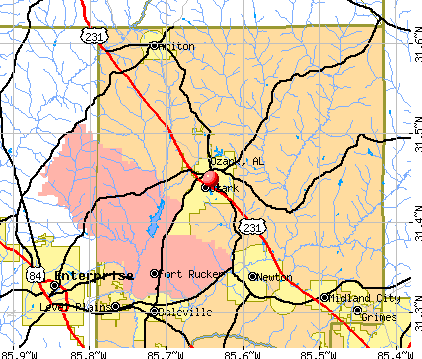
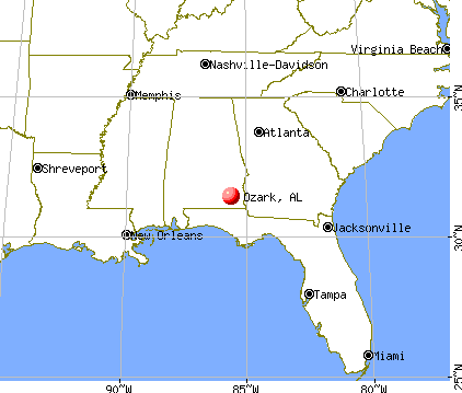
Ozark, Alabama
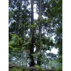
Ozark: Twin trees along the walking trail at Ed Lisenby Lake.

Ozark: a sunset near campground rd ozark, alabama
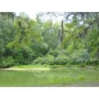
Ozark: A view of a bank by Ed Lisenby Lake.

Ozark: a sunset on near gunter street on a lake ozark, alabama

Ozark: a sunset in near campground road
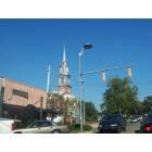
Ozark: Downtown Ozark

Ozark: a sunset on gunter street ozark, alabama

Ozark: early morning in ozark
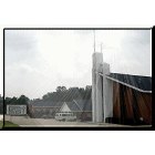
Ozark: Southside Baptist Church of HWY 123
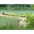
Ozark: A duck resting by Ed Lisenby Lake.
- add
your
Submit your own pictures of this city and show them to the world
- OSM Map
- General Map
- Google Map
- MSN Map
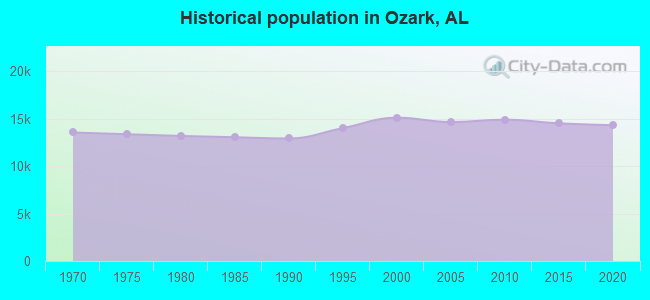
Population change since 2000: -5.4%
 |
| Males: 7,078 | |
| Females: 7,221 |
| Median resident age: | 41.2 years |
| Alabama median age: | 39.6 years |
Zip codes: 36360.
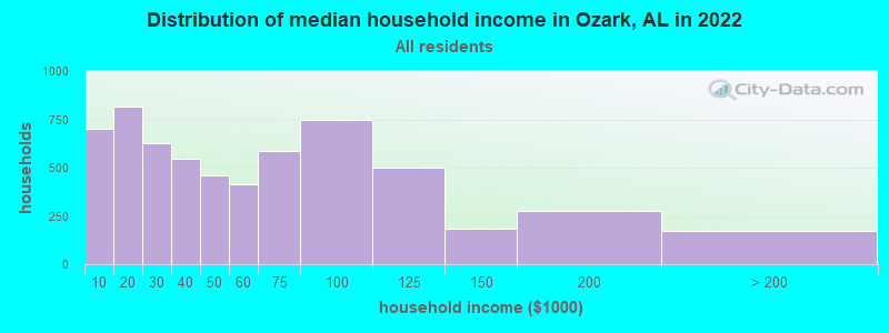
| Ozark: | $47,459 |
| AL: | $59,674 |
Estimated per capita income in 2022: $28,076 (it was $15,984 in 2000)
Ozark city income, earnings, and wages data
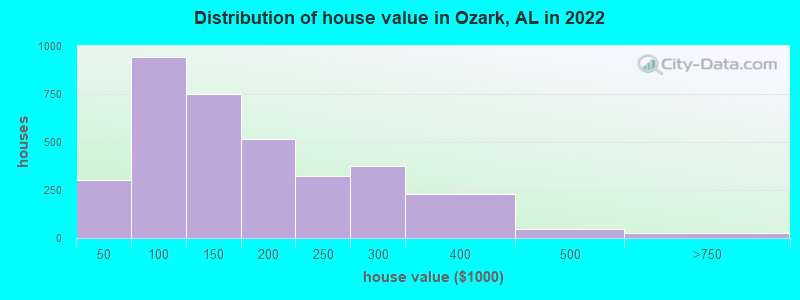
Estimated median house or condo value in 2022: $145,244 (it was $68,600 in 2000)
| Ozark: | $145,244 |
| AL: | $200,900 |
Median gross rent in 2022: $777.
(12.7% for White Non-Hispanic residents, 36.2% for Black residents, 30.8% for Hispanic or Latino residents, 7.9% for American Indian residents, 74.7% for other race residents, 30.9% for two or more races residents)
Detailed information about poverty and poor residents in Ozark, AL

Compare current foreclosures in Ozark, AL:
| Photo | Address | Area | Beds / Baths | Price | Details |
|---|---|---|---|---|---|

|
#1
Newton Ave
Ozark, AL 36360
|
2,135 sq. feet
|
1 baths 3 beds |
show details | |

|
#2
Hull St
Ozark, AL 36360
|
1,080 sq. feet
|
- baths - beds |
show details | |

|
#3
Hall Dr
Ozark, AL 36360
|
1,298 sq. feet
|
- baths - beds |
show details | |

|
#4
Osteen Rd
Ozark, AL 36360
|
- sq. feet
|
- baths - beds |
show details | |

|
#5
E Eufaula St Apt 23
Ozark, AL 36360
|
- sq. feet
|
- baths - beds |
show details | |

|
#6
Noah Cir
Ozark, AL 36360
|
- sq. feet
|
- baths - beds |
show details | |

|
#7
Brookwood Cir
Ozark, AL 36360
|
1,215 sq. feet
|
- baths - beds |
show details | |

|
#8
Atlas St
Ozark, AL 36360
|
- sq. feet
|
- baths - beds |
show details | |

|
#9
Will Logan Rd
Ozark, AL 36360
|
1,352 sq. feet
|
- baths - beds |
show details | |

|
#10
Greenbriar Dr
Ozark, AL 36360
|
1,350 sq. feet
|
- baths - beds |
show details |
| Photo | Address | Area | Beds / Baths | Price | Details |
|---|---|---|---|---|---|

|
#11
Private Road 1339
Ozark, AL 36360
|
- sq. feet
|
- baths - beds |
show details | |

|
#12
Mccants Dr
Ozark, AL 36360
|
- sq. feet
|
- baths - beds |
show details | |

|
#13
Newton Ave
Ozark, AL 36360
|
1,700 sq. feet
|
- baths - beds |
show details | |

|
#14
Harris Rd Apt 61
Ozark, AL 36360
|
- sq. feet
|
- baths - beds |
show details | |

|
#15
Harris Rd Apt 79
Ozark, AL 36360
|
- sq. feet
|
- baths - beds |
show details | |

|
#16
Anne St
Ozark, AL 36360
|
- sq. feet
|
- baths - beds |
show details | |

|
#17
Keirns Ct
Ozark, AL 36360
|
1,820 sq. feet
|
- baths - beds |
show details | |

|
#18
Newton Ave # B
Ozark, AL 36360
|
- sq. feet
|
- baths - beds |
show details | |

|
#19
Parker Hills Dr
Ozark, AL 36360
|
1,414 sq. feet
|
- baths - beds |
show details | |

|
#20
Riley Rd
Ozark, AL 36360
|
- sq. feet
|
- baths - beds |
show details |
| Photo | Address | Area | Beds / Baths | Price | Details |
|---|---|---|---|---|---|

|
#21
Candlewick Blvd
Ozark, AL 36360
|
- sq. feet
|
- baths - beds |
show details | |

|
#22
Ruby St
Ozark, AL 36360
|
1,608 sq. feet
|
- baths - beds |
show details | |

|
#23
Stratford Dr
Ozark, AL 36360
|
- sq. feet
|
- baths - beds |
show details | |

|
#24
County Road 15
Ozark, AL 36360
|
- sq. feet
|
- baths - beds |
show details | |

|
#25
Harris Rd Apt 16
Ozark, AL 36360
|
- sq. feet
|
- baths - beds |
show details | |

|
#26
Harris Rd Apt 606
Ozark, AL 36360
|
- sq. feet
|
- baths - beds |
show details | |

|
#27
Ross Dr
Ozark, AL 36360
|
- sq. feet
|
- baths - beds |
show details | |

|
#28
County Road 108
Ozark, AL 36360
|
- sq. feet
|
- baths - beds |
show details | |

|
#29
Rolling Hills Dr
Ozark, AL 36360
|
- sq. feet
|
- baths - beds |
show details | |

|
#30
Andrews Ave Apt 14c
Ozark, AL 36360
|
- sq. feet
|
- baths - beds |
show details |
| Photo | Address | Area | Beds / Baths | Price | Details |
|---|---|---|---|---|---|

|
#31
Riley Rd
Ozark, AL 36360
|
- sq. feet
|
- baths - beds |
show details | |

|
#32
Andrews Ave
Ozark, AL 36360
|
- sq. feet
|
- baths - beds |
show details | |

|
#33
Grimes Rd # 110
Ozark, AL 36360
|
- sq. feet
|
- baths - beds |
show details | |

|
#34
Gunter St
Ozark, AL 36360
|
1,338 sq. feet
|
- baths - beds |
show details | |

|
#35
N Union Ave
Ozark, AL 36360
|
2,740 sq. feet
|
- baths - beds |
show details | |

|
#36
Washington Ave
Ozark, AL 36360
|
902 sq. feet
|
- baths - beds |
show details | |

|
#37
Ben St
Ozark, AL 36360
|
1,107 sq. feet
|
- baths - beds |
show details | |

|
#38
County Road 11
Ozark, AL 36360
|
- sq. feet
|
- baths - beds |
show details | |

|
#39
Ed Lisenby Dr
Ozark, AL 36360
|
- sq. feet
|
- baths - beds |
show details | |

|
#40
King Ave
Ozark, AL 36360
|
- sq. feet
|
- baths - beds |
show details |
| Photo | Address | Area | Beds / Baths | Price | Details |
|---|---|---|---|---|---|

|
#41
W College St Apt 51
Ozark, AL 36360
|
- sq. feet
|
- baths - beds |
show details | |

|
#42
Green Village Rd
Ozark, AL 36360
|
1,134 sq. feet
|
- baths - beds |
show details | |

|
#43
Westview Dr
Ozark, AL 36360
|
- sq. feet
|
- baths - beds |
show details | |

|
#44
Spruce Ln
Ozark, AL 36360
|
1,706 sq. feet
|
- baths - beds |
show details | |

|
#45
Merrydell Dr
Ozark, AL 36360
|
1,164 sq. feet
|
- baths - beds |
show details | |

|
#46
Hazelwood St
Ozark, AL 36360
|
1,148 sq. feet
|
- baths - beds |
show details | |

|
#47
Victor Ln
Ozark, AL 36360
|
- sq. feet
|
- baths - beds |
show details | |

|
#48
Harris Rd Apt 33
Ozark, AL 36360
|
- sq. feet
|
- baths - beds |
show details | |

|
#49
Walker Rd
Ozark, AL 36360
|
1,336 sq. feet
|
- baths - beds |
show details | |

|
Check over 1 million property listings on Foreclosure.com!
|
browse all offers | |||

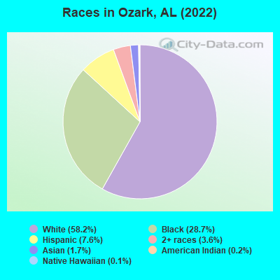
- 8,44358.2%White alone
- 4,16428.7%Black alone
- 1,1027.6%Hispanic
- 5153.6%Two or more races
- 2461.7%Asian alone
- 290.2%American Indian alone
- 150.1%Native Hawaiian and Other
Pacific Islander alone
According to our research of Alabama and other state lists, there were 90 registered sex offenders living in Ozark, Alabama as of June 08, 2024.
The ratio of all residents to sex offenders in Ozark is 164 to 1.
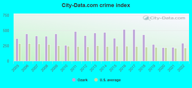
Type |
2009 |
2010 |
2011 |
2012 |
2013 |
2014 |
2015 |
2016 |
2017 |
2018 |
2019 |
2020 |
2021 |
2022 |
|---|---|---|---|---|---|---|---|---|---|---|---|---|---|---|
| Murders (per 100,000) | 1 (6.8) | 1 (6.7) | 1 (6.7) | 0 (0.0) | 0 (0.0) | 1 (6.7) | 1 (6.8) | 0 (0.0) | 3 (20.6) | 1 (7.0) | 0 (0.0) | 3 (21.1) | 2 (14.2) | 0 (0.0) |
| Rapes (per 100,000) | 8 (54.5) | 5 (33.5) | 6 (40.1) | 2 (13.4) | 14 (94.0) | 19 (128.0) | 12 (81.9) | 12 (81.7) | 11 (75.6) | 2 (13.9) | 3 (21.1) | 2 (14.1) | 5 (35.5) | 5 (35.0) |
| Robberies (per 100,000) | 24 (163.6) | 7 (47.0) | 24 (160.2) | 21 (140.9) | 17 (114.1) | 4 (26.9) | 8 (54.6) | 5 (34.1) | 5 (34.3) | 7 (48.8) | 2 (14.1) | 1 (7.0) | 2 (14.2) | 6 (42.0) |
| Assaults (per 100,000) | 75 (511.2) | 59 (395.8) | 79 (527.4) | 80 (536.6) | 55 (369.2) | 43 (289.7) | 47 (320.9) | 164 (1,117) | 137 (941.0) | 138 (961.1) | 72 (506.0) | 52 (365.8) | 38 (270.2) | 64 (447.6) |
| Burglaries (per 100,000) | 204 (1,391) | 5 (33.5) | 161 (1,075) | 173 (1,160) | 160 (1,074) | 184 (1,239) | 121 (826.2) | 102 (694.9) | 107 (734.9) | 88 (612.9) | 83 (583.4) | 50 (351.7) | 39 (277.3) | 65 (454.6) |
| Thefts (per 100,000) | 459 (3,129) | 426 (2,858) | 668 (4,460) | 590 (3,958) | 686 (4,605) | 681 (4,587) | 484 (3,305) | 561 (3,822) | 544 (3,737) | 493 (3,434) | 326 (2,291) | 207 (1,456) | 270 (1,920) | 389 (2,720) |
| Auto thefts (per 100,000) | 23 (156.8) | 21 (140.9) | 57 (380.5) | 30 (201.2) | 32 (214.8) | 35 (235.8) | 47 (320.9) | 28 (190.7) | 31 (212.9) | 38 (264.7) | 31 (217.9) | 17 (119.6) | 22 (156.4) | 37 (258.8) |
| Arson (per 100,000) | 1 (6.8) | 0 (0.0) | 2 (13.4) | 0 (0.0) | 2 (13.4) | 3 (20.2) | 3 (20.5) | 4 (27.2) | 2 (13.7) | 3 (20.9) | 0 (0.0) | 0 (0.0) | 2 (14.2) | 6 (42.0) |
| City-Data.com crime index | 443.6 | 261.4 | 483.0 | 416.0 | 459.8 | 471.0 | 375.5 | 515.8 | 518.1 | 433.3 | 272.2 | 221.2 | 223.9 | 291.4 |
The City-Data.com crime index weighs serious crimes and violent crimes more heavily. Higher means more crime, U.S. average is 246.1. It adjusts for the number of visitors and daily workers commuting into cities.
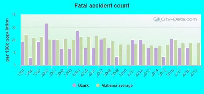
Crime rate in Ozark detailed stats: murders, rapes, robberies, assaults, burglaries, thefts, arson
Full-time law enforcement employees in 2021, including police officers: 32 (25 officers - 23 male; 2 female).
| Officers per 1,000 residents here: | 1.78 |
| Alabama average: | 2.40 |
 Recent articles from our blog. Our writers, many of them Ph.D. graduates or candidates, create easy-to-read articles on a wide variety of topics.

 | Town Madison Update Thread (700 replies) |
| Montgomery vs Dothan area (46 replies) |
| Best route from Jacksonville to Montgomery (9 replies) |
| Crazy to consider a move (38 replies) |
| Where are the extra 100,000 people? (22 replies) |
| 100+ Largest Cities in Alabama (16 replies) |
Latest news from Ozark, AL collected exclusively by city-data.com from local newspapers, TV, and radio stations
Ancestries: American (23.2%), English (8.1%), Irish (3.2%), German (2.5%), Scotch-Irish (1.4%), European (1.2%).
Current Local Time: CST time zone
Incorporated in 1870
Elevation: 409 feet
Land area: 34.2 square miles.
Population density: 418 people per square mile (low).
740 residents are foreign born (2.5% Latin America, 1.6% Asia, 1.0% Europe).
| This city: | 5.1% |
| Alabama: | 3.5% |
Median real estate property taxes paid for housing units with mortgages in 2022: $603 (0.4%)
Median real estate property taxes paid for housing units with no mortgage in 2022: $465 (0.4%)
Nearest city with pop. 50,000+: Dothan, AL  (20.6 miles , pop. 57,737).
Nearest city with pop. 200,000+: Montgomery, AL (73.4 miles , pop. 201,568).
Nearest city with pop. 1,000,000+: Houston, TX (591.3 miles , pop. 1,953,631).
Nearest cities:
), ), ), ), ), Latitude: 31.45 N, Longitude: 85.64 W
Daytime population change due to commuting: -315 (-2.2%)
Workers who live and work in this city: 2,197 (44.0%)
Area code: 334
Ozark, Alabama accommodation & food services, waste management - Economy and Business Data
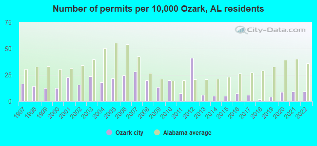
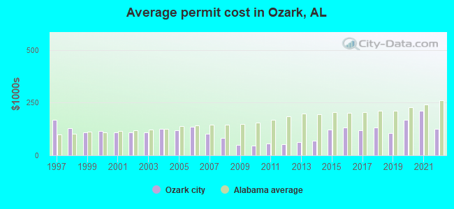
Single-family new house construction building permits:
- 2022: 14 buildings, average cost: $126,800
- 2021: 14 buildings, average cost: $210,800
- 2020: 13 buildings, average cost: $169,300
- 2019: 6 buildings, average cost: $105,700
- 2018: 3 buildings, average cost: $131,600
- 2017: 9 buildings, average cost: $119,600
- 2016: 11 buildings, average cost: $130,500
- 2015: 8 buildings, average cost: $121,900
- 2014: 8 buildings, average cost: $69,300
- 2013: 9 buildings, average cost: $63,600
- 2012: 62 buildings, average cost: $53,300
- 2011: 11 buildings, average cost: $56,000
- 2010: 30 buildings, average cost: $45,500
- 2009: 20 buildings, average cost: $49,600
- 2008: 30 buildings, average cost: $83,200
- 2007: 43 buildings, average cost: $101,800
- 2006: 37 buildings, average cost: $136,900
- 2005: 33 buildings, average cost: $120,100
- 2004: 27 buildings, average cost: $124,400
- 2003: 36 buildings, average cost: $110,400
- 2002: 24 buildings, average cost: $109,400
- 2001: 34 buildings, average cost: $109,300
- 2000: 19 buildings, average cost: $116,900
- 1999: 19 buildings, average cost: $110,100
- 1998: 22 buildings, average cost: $128,200
- 1997: 25 buildings, average cost: $167,800
| Here: | 2.8% |
| Alabama: | 2.6% |
- Health care (10.8%)
- Public administration (8.4%)
- Educational services (8.3%)
- Accommodation & food services (7.6%)
- Other transportation, support activities, couriers (6.3%)
- Construction (5.5%)
- Administrative & support & waste management services (4.3%)
- Other transportation, support activities, couriers (10.7%)
- Public administration (10.2%)
- Construction (10.1%)
- Accommodation & food services (7.0%)
- Educational services (5.3%)
- Administrative & support & waste management services (5.1%)
- Motor vehicle & parts dealers (3.6%)
- Health care (19.2%)
- Educational services (11.6%)
- Accommodation & food services (8.3%)
- Public administration (6.5%)
- Department & other general merchandise stores (6.2%)
- Apparel (4.7%)
- Finance & insurance (4.6%)
- Vehicle and mobile equipment mechanics, installers, and repairers (5.8%)
- Building and grounds cleaning and maintenance occupations (4.7%)
- Secretaries and administrative assistants (3.8%)
- Other sales and related occupations, including supervisors (3.6%)
- Retail sales workers, except cashiers (3.4%)
- Other management occupations, except farmers and farm managers (3.3%)
- Other production occupations, including supervisors (2.8%)
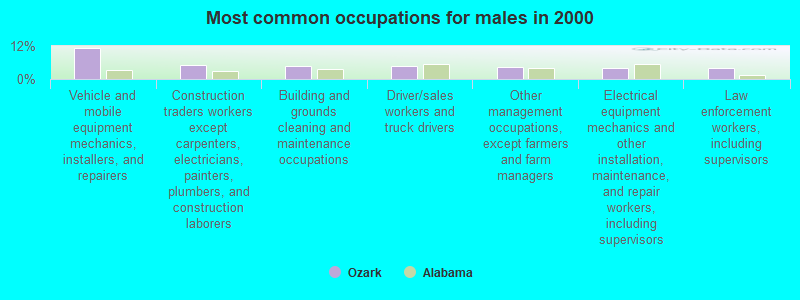
- Vehicle and mobile equipment mechanics, installers, and repairers (11.2%)
- Construction traders workers except carpenters, electricians, painters, plumbers, and construction laborers (5.0%)
- Building and grounds cleaning and maintenance occupations (4.7%)
- Driver/sales workers and truck drivers (4.6%)
- Other management occupations, except farmers and farm managers (4.4%)
- Electrical equipment mechanics and other installation, maintenance, and repair workers, including supervisors (4.1%)
- Law enforcement workers, including supervisors (4.1%)
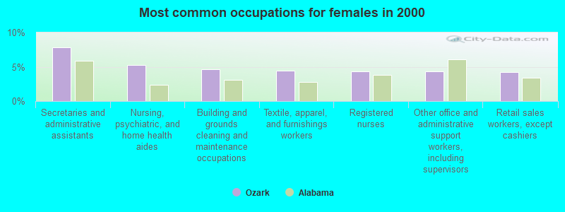
- Secretaries and administrative assistants (7.9%)
- Nursing, psychiatric, and home health aides (5.3%)
- Building and grounds cleaning and maintenance occupations (4.6%)
- Textile, apparel, and furnishings workers (4.4%)
- Registered nurses (4.4%)
- Other office and administrative support workers, including supervisors (4.3%)
- Retail sales workers, except cashiers (4.2%)
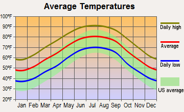
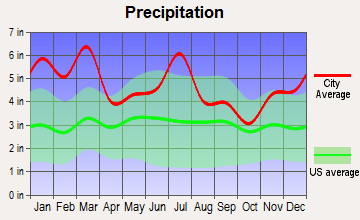
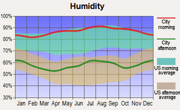
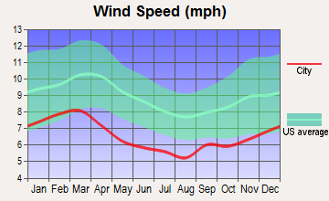
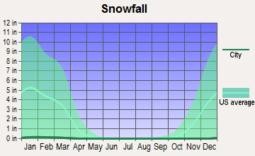
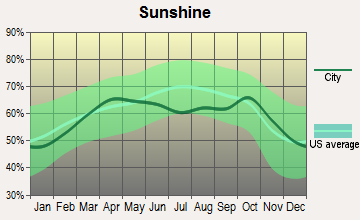
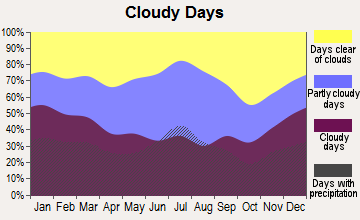
Average climate in Ozark, Alabama
Based on data reported by over 4,000 weather stations
|
|

(lower is better)
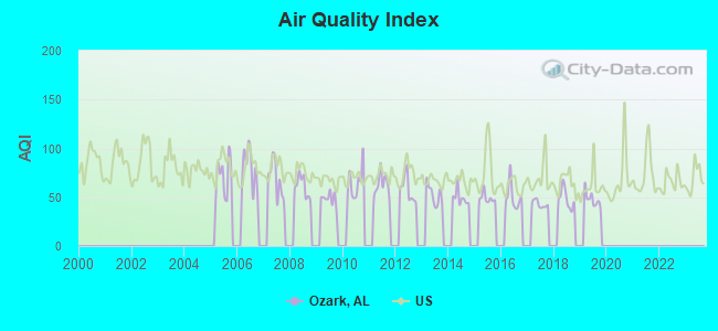
Air Quality Index (AQI) level in 2019 was 47.9. This is significantly better than average.
| City: | 47.9 |
| U.S.: | 72.6 |
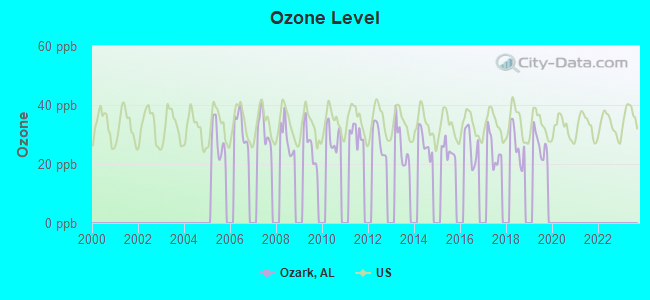
Ozone [ppb] level in 2019 was 26.7. This is better than average. Closest monitor was 22.1 miles away from the city center.
| City: | 26.7 |
| U.S.: | 33.3 |
Tornado activity:
Ozark-area historical tornado activity is slightly below Alabama state average. It is 51% greater than the overall U.S. average.
On 3/1/2007, a category F4 (max. wind speeds 207-260 mph) tornado 20.1 miles away from the Ozark city center killed 9 people and injured 50 people and caused $250 million in damages.
On 12/30/1973, a category F3 (max. wind speeds 158-206 mph) tornado 0.5 miles away from the city center injured 14 people and caused between $500 and $5000 in damages.
Earthquake activity:
Ozark-area historical earthquake activity is significantly above Alabama state average. It is 19% greater than the overall U.S. average.On 10/24/1997 at 08:35:17, a magnitude 4.9 (4.8 MB, 4.2 MS, 4.9 LG, Depth: 6.2 mi, Class: Light, Intensity: IV - V) earthquake occurred 98.9 miles away from the city center
On 1/18/1999 at 07:00:53, a magnitude 4.8 (4.8 MB, 4.0 LG, Depth: 0.6 mi) earthquake occurred 164.9 miles away from Ozark center
On 4/29/2003 at 08:59:39, a magnitude 4.9 (4.4 MB, 4.6 MW, 4.9 LG) earthquake occurred 210.7 miles away from the city center
On 8/2/1974 at 08:52:09, a magnitude 4.9 (4.3 MB, 4.9 LG) earthquake occurred 248.6 miles away from the city center
On 4/29/2003 at 08:59:39, a magnitude 4.6 (4.6 MW, Depth: 12.3 mi) earthquake occurred 210.7 miles away from the city center
On 11/7/2004 at 11:20:21, a magnitude 4.3 (4.3 MW, Depth: 3.1 mi) earthquake occurred 157.9 miles away from Ozark center
Magnitude types: regional Lg-wave magnitude (LG), body-wave magnitude (MB), surface-wave magnitude (MS), moment magnitude (MW)
Natural disasters:
The number of natural disasters in Dale County (24) is greater than the US average (15).Major Disasters (Presidential) Declared: 17
Emergencies Declared: 5
Causes of natural disasters: Storms: 14, Tornadoes: 10, Floods: 9, Hurricanes: 6, Winds: 4, Drought: 1, Snowfall: 1, Tropical Storm: 1, Winter Storm: 1, Other: 1 (Note: some incidents may be assigned to more than one category).
Hospitals and medical centers in Ozark:
- COMMUNITY HOSPICE OF DALE MEDICAL CENTER (318 JAMES STREET, SUITE C)
- DALE MEDICAL CENTER (Government - Hospital District or Authority, provides emergency services, 126 HOSPITAL AVE)
- WIREGRASS HOSPICE OZARK (1970 EAST ANDREWS AVENUE)
- OAKVIEW MANOR HEALTH CARE CENTER (929 MIXON SCHOOL ROAD)
- OZARK HEALTH AND REHABILITATION, LLC (312 BRYAN DRIVE)
- OZARK DIALYSIS (214 HOSPITAL AVENUE)
- AMEDISYS HOME HEALTH OF OZARK (123 S PAINTER AVENUE, SUITE C)
- DALE MEDICAL CTR HOME HEALTH (126 HOSPITAL AVENUE)
Airports and heliports located in Ozark:
- Blackwell Field Airport (71J) (Runways: 1, Itinerant Ops: 54,300, Local Ops: 37,200)
- Cairns Aaf (Fort Rucker) Airport (OZR) (Runways: 2)
- Hidden Springs Airpark Airport (36AL) (Runways: 1)
- Heliports: 7
Colleges/universities with over 2000 students nearest to Ozark:
- George C Wallace State Community College-Dothan (about 14 miles; Dothan, AL; Full-time enrollment: 3,611)
- Enterprise State Community College (about 16 miles; Enterprise, AL; FT enrollment: 2,101)
- Troy University (about 31 miles; Troy, AL; FT enrollment: 16,148)
- Tuskegee University (about 69 miles; Tuskegee, AL; FT enrollment: 2,810)
- Auburn University at Montgomery (about 72 miles; Montgomery, AL; FT enrollment: 4,092)
- Faulkner University (about 73 miles; Montgomery, AL; FT enrollment: 2,887)
- Alabama State University (about 75 miles; Montgomery, AL; FT enrollment: 5,457)
Public high schools in Ozark:
- CARROLL HIGH SCH (Students: 848, Location: 315 EAGLE WAY, Grades: 9-12)
- ALT LEARNING CTR (Location: 401 MARTIN STREET, Grades: 7-12)
- CARROLL HIGH SCH CAREER CTR (Location: 227 FAUST AVE, Grades: 9-12)
Private high schools in Ozark:
Public elementary/middle schools in Ozark:
- D A SMITH MIDDLE SCH (Students: 593, Location: 994 ANDREWS AVENUE, Grades: 6-8)
- HARRY N MIXON ELEM SCH (Students: 539, Location: 349 SHERRILL LN, Grades: 1-5)
- JOSEPH W LISENBY ELEMENTARY SCHOOL (Students: 433, Location: 860 FAUST AVE, Grades: 1-5)
Points of interest:
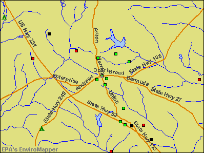
Notable locations in Ozark: Ozark Country Club (A), Dale County Courthouse (B), SpectraCare Health Systems Dale County Clinic (C), Chancey Fire Station (D), Dowling Fire Station (E), Ozark Fire Department Station 3 (F). Display/hide their locations on the map
Shopping Center: Martindale Plaza Shopping Center (1). Display/hide its location on the map
Churches in Ozark include: Calvary Church (A), Faith Church (B), First Baptist Church (C), First Presbyterian Church (D), Kingdom Hall of Jehovah Witnesses Church (E), Lighthouse Church (F), Dean Church (G), Freedom Church (H), Logan Road Church (I). Display/hide their locations on the map
Cemeteries: Claybank Cemetery (1), Old Dean Church Cemetery (2), Campground Cemetery (3), Travelers Rest Cemetery (4). Display/hide their locations on the map
Reservoirs: Parker Lakes (A), Mixon Lake (B), Dale County Public Lake (C), Jernegans Pond (D), Roy Parker Lake (E), Williams Lake (F), Marley Millpond (G), Marvin Parker Lake Number Two (H). Display/hide their locations on the map
Parks in Ozark include: Comer Field (1), Sam Dale Park (2). Display/hide their locations on the map
Tourist attraction: Southeast Alabama Qdm Association (Recreation Areas; 2721 A B Stubbs Road) (1). Display/hide its approximate location on the map
Hotels: All American Ozark Inn (2064 South US Highway 231) (1), Ozark Motel (2466 North US Highway 231) (2), Queenies Auto Sales (2466 North US Highway 231) (3), Hi-Way Rest Motel (3022 North US Highway 231) (4), Quality Inn (858 South US Highway 231) (5), Budget Inn (Highway 231 South) (6), Jameson Inn (1360 South US Highway 231) (7), Holiday Inn Ozark-Ft. Rucker- Al (151 Highway 231 N) (8), Baywood Suites of Ozark (305 Newton Avenue Apt 40) (9). Display/hide their approximate locations on the map
Courts: Dale County - Juvenile Court Services (Court Square) (1), Dale Geneva Court Ref Program (299 South Painter Avenue) (2), Alabama State - Judge William B Matthews- Judicial Branch- Alcoholic Beverage Control B (Court Square) (3), Ozark - Municipal Court (275 North Union Avenue) (4), Alabama State - Judicial Branch- Alcoholic Beverage Control Board- District C (Court Square) (5), Alabama State - Judicial Branch- Circuit Court- Judge P B McLaughlin (Court Square) (6). Display/hide their approximate locations on the map
Birthplace of: Josh Savage - 2005 NFL player (Tampa Bay Buccaneers, born: Sep 28, 1980), Marc Ronan - Baseball player, Steve McLendon - Football player, Wilbur Jackson - Football player.
Drinking water stations with addresses in Ozark and their reported violations in the past:
OZARK UTILITIES BOARD (Population served: 19,200, Groundwater):Past monitoring violations:DALE COUNTY WATER AUTHORITY (Address: 283 Campus Drive , Population served: 7,932, Groundwater):
- 21 regular monitoring violations
Past monitoring violations:
- Lead Consumer Notice - In SEP-09-2011, Contaminant: Lead and Copper Rule. Follow-up actions: St Compliance achieved (SEP-22-2011), St Violation/Reminder Notice (APR-04-2012)
- Follow-up Or Routine LCR Tap M/R - In OCT-11-2005, Contaminant: Lead and Copper Rule. Follow-up actions: St Compliance achieved (NOV-21-2008)
| This city: | 2.4 people |
| Alabama: | 2.5 people |
| This city: | 65.5% |
| Whole state: | 67.8% |
| This city: | 4.7% |
| Whole state: | 4.7% |
Likely homosexual households (counted as self-reported same-sex unmarried-partner households)
- Lesbian couples: 0.1% of all households
- Gay men: 0.3% of all households
People in group quarters in Ozark in 2010:
- 262 people in nursing facilities/skilled-nursing facilities
- 63 people in local jails and other municipal confinement facilities
- 10 people in other noninstitutional facilities
- 3 people in emergency and transitional shelters (with sleeping facilities) for people experiencing homelessness
People in group quarters in Ozark in 2000:
- 369 people in nursing homes
- 51 people in local jails and other confinement facilities (including police lockups)
- 22 people in other noninstitutional group quarters
Banks with branches in Ozark (2011 data):
- THE COMMERCIAL BANK OF OZARK: Martindale Plaza Branch at 1301 E. Andrews Ave., branch established on 1972/01/10; The Commercial Bank Of Ozark at 208 South Merrick Avenue, branch established on 1959/04/02. Info updated 2006/11/03: Bank assets: $76.5 mil, Deposits: $68.4 mil, local headquarters, positive income, 3 total offices, Holding Company: Commercial Bancshares Of Ozark, Inc.
- Branch Banking and Trust Company: Ozark Branch at 253 South Union Avenue, branch established on 1978/11/02. Info updated 2010/03/29: Bank assets: $168,867.6 mil, Deposits: $127,549.5 mil, headquarters in Winston Salem, NC, positive income, Commercial Lending Specialization, 1793 total offices, Holding Company: Bb&T Corporation
- Wells Fargo Bank, National Association: Main Office Ozark at 293 Andrews Avenue, branch established on 1934/10/20. Info updated 2011/04/05: Bank assets: $1,161,490.0 mil, Deposits: $905,653.0 mil, headquarters in Sioux Falls, SD, positive income, 6395 total offices, Holding Company: Wells Fargo & Company
- PeoplesSouth Bank: Ozark Branch at 101 Painter Avenue, branch established on 1996/01/02. Info updated 2006/11/03: Bank assets: $534.5 mil, Deposits: $446.4 mil, headquarters in Colquitt, GA, positive income, Commercial Lending Specialization, 19 total offices, Holding Company: Peoplessouth Bancshares, Inc.
- Synovus Bank: Ozark Branch at 500 East Andrews Avenue, branch established on 1970/09/08. Info updated 2011/01/25: Bank assets: $26,863.3 mil, Deposits: $22,415.0 mil, headquarters in Columbus, GA, positive income, Commercial Lending Specialization, 296 total offices, Holding Company: Synovus Financial Corp.
For population 15 years and over in Ozark:
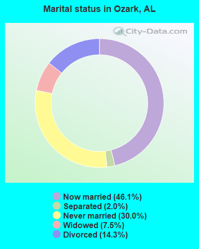
- Never married: 30.0%
- Now married: 46.1%
- Separated: 2.0%
- Widowed: 7.5%
- Divorced: 14.3%
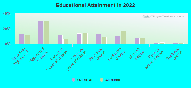
For population 25 years and over in Ozark:
- High school or higher: 86.4%
- Bachelor's degree or higher: 18.5%
- Graduate or professional degree: 8.4%
- Unemployed: 9.2%
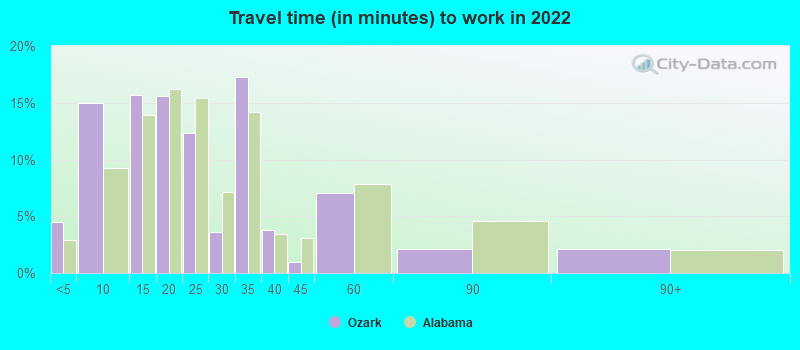
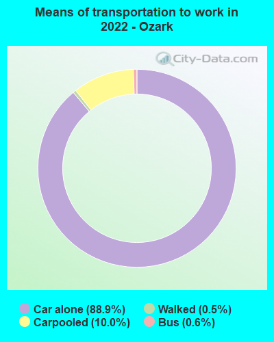
- Mean travel time to work (commute): 22.7 minutes
| Here: | 12.0 |
| Alabama average: | 11.5 |
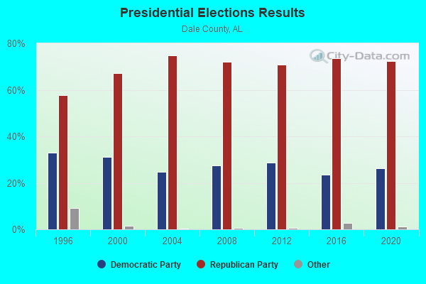
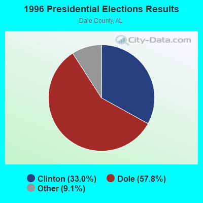
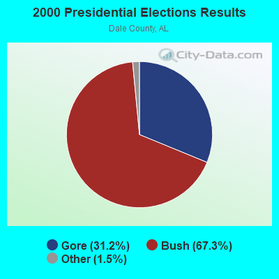


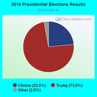

Graphs represent county-level data. Detailed 2008 Election Results
Religion statistics for Ozark, AL (based on Dale County data)
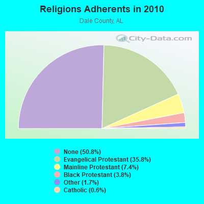
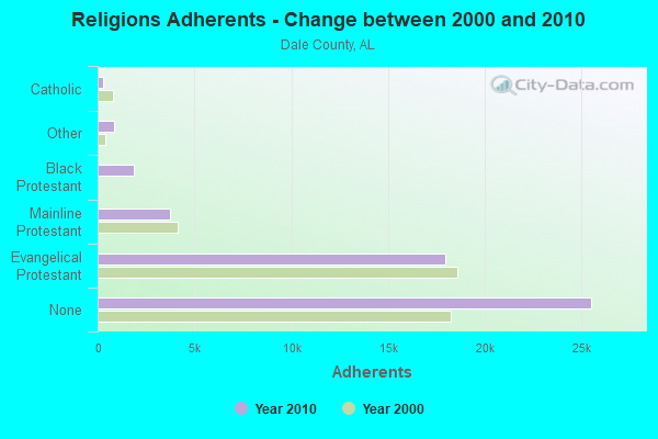
| Religion | Adherents | Congregations |
|---|---|---|
| Evangelical Protestant | 17,979 | 68 |
| Mainline Protestant | 3,712 | 27 |
| Black Protestant | 1,891 | 9 |
| Other | 872 | 4 |
| Catholic | 278 | 1 |
| None | 25,519 | - |
Food Environment Statistics:
| Dale County: | 1.66 / 10,000 pop. |
| Alabama: | 1.89 / 10,000 pop. |
| Here: | 0.21 / 10,000 pop. |
| Alabama: | 0.20 / 10,000 pop. |
| Here: | 0.62 / 10,000 pop. |
| Alabama: | 0.65 / 10,000 pop. |
| Here: | 6.65 / 10,000 pop. |
| State: | 6.32 / 10,000 pop. |
| This county: | 4.98 / 10,000 pop. |
| Alabama: | 5.75 / 10,000 pop. |
| Dale County: | 12.5% |
| State: | 11.8% |
| Here: | 33.1% |
| State: | 31.7% |
| This county: | 11.1% |
| Alabama: | 13.5% |
Health and Nutrition:
| Here: | 49.7% |
| Alabama: | 49.0% |
| Ozark: | 46.5% |
| Alabama: | 45.7% |
| Here: | 29.2 |
| Alabama: | 28.9 |
| Ozark: | 21.4% |
| Alabama: | 20.7% |
| This city: | 12.0% |
| Alabama: | 11.0% |
| Here: | 6.8 |
| Alabama: | 6.8 |
| Here: | 35.7% |
| Alabama: | 34.4% |
| This city: | 55.1% |
| State: | 55.2% |
| This city: | 78.6% |
| Alabama: | 79.3% |
More about Health and Nutrition of Ozark, AL Residents
| Local government employment and payroll (March 2022) | |||||
| Function | Full-time employees | Monthly full-time payroll | Average yearly full-time wage | Part-time employees | Monthly part-time payroll |
|---|---|---|---|---|---|
| Firefighters | 29 | $110,579 | $45,757 | 0 | $0 |
| Police Protection - Officers | 26 | $115,871 | $53,479 | 2 | $5,146 |
| Streets and Highways | 17 | $43,788 | $30,909 | 1 | $1,269 |
| Solid Waste Management | 16 | $37,477 | $28,108 | 1 | $887 |
| Fire - Other | 14 | $62,445 | $53,524 | 4 | $7,276 |
| Parks and Recreation | 13 | $32,701 | $30,186 | 13 | $10,290 |
| Other and Unallocable | 11 | $36,319 | $39,621 | 5 | $2,233 |
| Water Supply | 10 | $47,910 | $57,492 | 0 | $0 |
| Sewerage | 10 | $47,302 | $56,762 | 0 | $0 |
| Other Government Administration | 5 | $8,867 | $21,281 | 5 | $3,065 |
| Police - Other | 4 | $10,283 | $30,849 | 4 | $1,384 |
| Health | 3 | $6,266 | $25,064 | 0 | $0 |
| Financial Administration | 3 | $12,511 | $50,044 | 1 | $1,568 |
| Judicial and Legal | 2 | $5,042 | $30,252 | 1 | $1,515 |
| Welfare | 1 | $2,389 | $28,668 | 0 | $0 |
| Airports | 1 | $1,991 | $23,892 | 0 | $0 |
| Totals for Government | 165 | $581,740 | $42,308 | 37 | $34,632 |
Ozark government finances - Expenditure in 2018 (per resident):
- Construction - Water Utilities: $1,939,000 ($135.60)
Regular Highways: $1,895,000 ($132.53)
General - Other: $1,137,000 ($79.52)
Sewerage: $587,000 ($41.05)
- Current Operations - Police Protection: $2,980,000 ($208.41)
Local Fire Protection: $2,454,000 ($171.62)
Parks and Recreation: $1,991,000 ($139.24)
Central Staff Services: $1,700,000 ($118.89)
Solid Waste Management: $1,342,000 ($93.85)
General - Other: $1,338,000 ($93.57)
Health - Other: $1,050,000 ($73.43)
Regular Highways: $862,000 ($60.28)
Judicial and Legal Services: $466,000 ($32.59)
Air Transportation: $22,000 ($1.54)
- General - Interest on Debt: $199,000 ($13.92)
- Intergovernmental to Local - Other - Elementary and Secondary Education: $2,168,000 ($151.62)
- Other Capital Outlay - Parks and Recreation: $62,000 ($4.34)
Transit Utilities: $22,000 ($1.54)
Libraries: $5,000 ($0.35)
General - Other: $5,000 ($0.35)
Judicial and Legal Services: $3,000 ($0.21)
Protective Inspection and Regulation - Other: $1,000 ($0.07)
- Total Salaries and Wages: $10,911,000 ($763.06)
Ozark government finances - Revenue in 2018 (per resident):
- Charges - Solid Waste Management: $597,000 ($41.75)
Other: $399,000 ($27.90)
- Federal Intergovernmental - Other: $676,000 ($47.28)
- Local Intergovernmental - General Local Government Support: $136,000 ($9.51)
- Miscellaneous - Fines and Forfeits: $844,000 ($59.03)
General Revenue - Other: $287,000 ($20.07)
Interest Earnings: $33,000 ($2.31)
Donations From Private Sources: $2,000 ($0.14)
- State Intergovernmental - General Local Government Support: $499,000 ($34.90)
Highways: $122,000 ($8.53)
Other: $86,000 ($6.01)
- Tax - General Sales and Gross Receipts: $7,815,000 ($546.54)
Property: $1,157,000 ($80.91)
Motor Fuels Sales: $532,000 ($37.21)
Public Utilities Sales: $486,000 ($33.99)
Tobacco Products Sales: $336,000 ($23.50)
Alcoholic Beverage Sales: $238,000 ($16.64)
Other Selective Sales: $130,000 ($9.09)
Ozark government finances - Cash and Securities in 2018 (per resident):
- Bond Funds - Cash and Securities: $286,000 ($20.00)
- Other Funds - Cash and Securities: $4,461,000 ($311.98)
13.66% of this county's 2021 resident taxpayers lived in other counties in 2020 ($45,663 average adjusted gross income)
| Here: | 13.66% |
| Alabama average: | 6.87% |
0.30% of residents moved from foreign countries ($1,125 average AGI)
Dale County: 0.30% Alabama average: 0.02%
Top counties from which taxpayers relocated into this county between 2020 and 2021:
| from Houston County, AL | |
| from Coffee County, AL | |
| from Henry County, AL |
12.52% of this county's 2020 resident taxpayers moved to other counties in 2021 ($49,280 average adjusted gross income)
| Here: | 12.52% |
| Alabama average: | 6.41% |
0.33% of residents moved to foreign countries ($1,788 average AGI)
Dale County: 0.33% Alabama average: 0.02%
Top counties to which taxpayers relocated from this county between 2020 and 2021:
| to Houston County, AL | |
| to Coffee County, AL | |
| to Henry County, AL |
| Businesses in Ozark, AL | ||||
| Name | Count | Name | Count | |
|---|---|---|---|---|
| AT&T | 2 | KFC | 1 | |
| Ace Hardware | 1 | Little Caesars Pizza | 1 | |
| Applebee's | 1 | McDonald's | 1 | |
| Arby's | 1 | Microtel | 1 | |
| AutoZone | 1 | Nike | 2 | |
| Burger King | 1 | Pizza Hut | 1 | |
| CVS | 1 | Quality | 1 | |
| Chevrolet | 1 | SONIC Drive-In | 1 | |
| Church's Chicken | 1 | Sears | 1 | |
| Dairy Queen | 1 | Subway | 2 | |
| Domino's Pizza | 1 | Taco Bell | 1 | |
| FedEx | 2 | U-Haul | 3 | |
| Ford | 1 | UPS | 1 | |
| Goodwill | 1 | Waffle House | 1 | |
| H&R Block | 1 | Walmart | 1 | |
| Hardee's | 1 | Wendy's | 1 | |
Strongest AM radio stations in Ozark:
- WQLS (1200 AM; 10 kW; OZARK, AL; Owner: STYLES BROADCASTING OF DOTHAN, INC.)
- WOZK (900 AM; 1 kW; OZARK, AL; Owner: OZARK B/CING. CORP.)
- WTKN (1560 AM; daytime; 5 kW; DALEVILLE, AL; Owner: JOSEPH A. ADAMS, SR.)
- WOOF (560 AM; 5 kW; DOTHAN, AL; Owner: WOOF, INC.)
- WTBF (970 AM; 5 kW; TROY, AL; Owner: TROY BROADCASTING CORP.)
- WAGF (1320 AM; 2 kW; DOTHAN, AL)
- WSTT (730 AM; 25 kW; THOMASVILLE, GA; Owner: MARION R. WILLIAMS)
- WASG (550 AM; 25 kW; ATMORE, AL; Owner: 550 AM, INC)
- WJOX (690 AM; 50 kW; BIRMINGHAM, AL; Owner: CITADEL BROADCASTING COMPANY)
- WGST (640 AM; 50 kW; ATLANTA, GA; Owner: CITICASTERS LICENSES, L.P.)
- WMSP (740 AM; 10 kW; MONTGOMERY, AL; Owner: CUMULUS LICENSING CORP.)
- WMAC (940 AM; 50 kW; MACON, GA; Owner: CUMULUS LICENSING CORP.)
- WNSI (810 AM; 50 kW; JACKSONVILLE, AL; Owner: UNITED BROADCASTING NETWORK, INC.)
Strongest FM radio stations in Ozark:
- WOAB (104.9 FM; OZARK, AL; Owner: OZARK BROADCASTING CORPORATION)
- WAQG (91.7 FM; OZARK, AL; Owner: AMERICAN FAMILY ASSOCIATION)
- WDYF (90.3 FM; DOTHAN, AL; Owner: FAITH BROADCASTING, INC.)
- WXUS (100.5 FM; FORT RUCKER, AL; Owner: SKYWAY BROADCASTING, LTD.)
- WKMX (106.7 FM; ENTERPRISE, AL; Owner: WKMX, INC.)
- WJRL-FM (103.9 FM; OZARK, AL; Owner: STYLES BROADCASTING OF DOTHAN, INC.)
- WOOF-FM (99.7 FM; DOTHAN, AL; Owner: WOOF, INC.)
- WTVY-FM (95.5 FM; DOTHAN, AL; Owner: STYLES BROADCASTING OF DOTHAN, INC.)
- WZTZ (101.1 FM; ELBA, AL; Owner: ELBA RADIO COMPANY)
- WDJR (96.9 FM; ENTERPRISE, AL; Owner: GULF SOUTH COMMUNICATIONS, INC.)
- WRWA (88.7 FM; DOTHAN, AL; Owner: TROY STATE UNIVERSITY)
- WQLD (104.3 FM; LUVERNE, AL; Owner: CAPSTAR TX LIMITED PARTNERSHIP)
- WZHT (105.7 FM; TROY, AL; Owner: CAPSTAR TX LIMITED PARTNERSHIP)
- WIZB (94.3 FM; ABBEVILLE, AL; Owner: CELEBRATIONS COMMUNICATIONS COMPANY, INC.)
- WRJM-FM (93.7 FM; GENEVA, AL; Owner: STAGE DOOR DEVELOPMENT, INC.)
- WAGF-FM (101.3 FM; DOTHAN, AL; Owner: WILSON BROADCASTING CO., INC.)
- WESP (102.5 FM; DOTHAN, AL; Owner: GULF SOUTH COMMUNICATIONS, INC)
- WTBF-FM (94.7 FM; BRUNDIDGE, AL; Owner: TROY BROADCASTING CORPORATION)
- WAXU (91.1 FM; TROY, AL; Owner: AMERICAN FAMILY ASSOCIATION)
- WVOB (91.3 FM; DOTHAN, AL; Owner: BETHANY BIBLE COLLEGE & B.T.S. INC.)
TV broadcast stations around Ozark:
- WDFX-TV (Channel 34; OZARK, AL; Owner: WAITT LICENSE CO. OF ALABAMA, L.L.C.)
- WTVY (Channel 4; DOTHAN, AL; Owner: GRAY MIDAMERICA TV LICENSEE CORP.)
- WGIQ (Channel 43; LOUISVILLE, AL; Owner: ALABAMA EDUCATIONAL TELEVISION COMMISSION)
- WRJM-TV (Channel 67; TROY, AL; Owner: JOSIE PARK BROADCASTING, INC.)
- WSFA (Channel 12; MONTGOMERY, AL; Owner: LIBCO, INC.)
- WDHN (Channel 18; DOTHAN, AL; Owner: MORRIS NETWORK OF ALABAMA, INC.)
- WCOV-TV (Channel 20; MONTGOMERY, AL; Owner: WOODS COMMUNICATIONS CORPORATION)
- WDIQ (Channel 2; DOZIER, AL; Owner: ALABAMA EDUCATIONAL TELEVISION COMMISSION)
- WJJN-LP (Channel 5; DOTHAN, AL; Owner: JAMES WILSON, III)
- W41BN (Channel 41; DOTHAN, AL; Owner: TRINITY BROADCASTING NETWORK)
- National Bridge Inventory (NBI) Statistics
- 46Number of bridges
- 486ft / 148mTotal length
- $48,978,000Total costs
- 107,046Total average daily traffic
- 12,058Total average daily truck traffic
- 149,588Total future (year 2033) average daily traffic
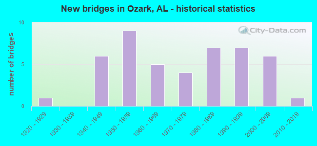
- New bridges - historical statistics
- 11920-1929
- 61940-1949
- 91950-1959
- 51960-1969
- 41970-1979
- 71980-1989
- 71990-1999
- 62000-2009
- 12010-2019
FCC Registered Antenna Towers: 173 (See the full list of FCC Registered Antenna Towers)
FCC Registered Commercial Land Mobile Towers: 2 (See the full list of FCC Registered Commercial Land Mobile Towers in Ozark, AL)
FCC Registered Broadcast Land Mobile Towers: 16 (See the full list of FCC Registered Broadcast Land Mobile Towers)
FCC Registered Microwave Towers: 21 (See the full list of FCC Registered Microwave Towers in this town)
FCC Registered Paging Towers: 2 (See the full list of FCC Registered Paging Towers)
FCC Registered Amateur Radio Licenses: 122 (See the full list of FCC Registered Amateur Radio Licenses in Ozark)
FAA Registered Aircraft: 56 (See the full list of FAA Registered Aircraft in Ozark)
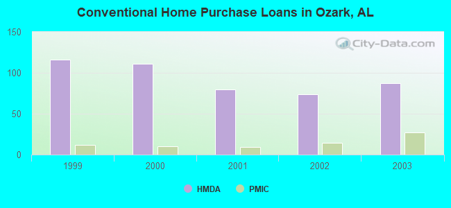
| Home Mortgage Disclosure Act Aggregated Statistics For Year 2003 (Based on 4 partial tracts) | ||||||||||||
| A) FHA, FSA/RHS & VA Home Purchase Loans | B) Conventional Home Purchase Loans | C) Refinancings | D) Home Improvement Loans | E) Loans on Dwellings For 5+ Families | F) Non-occupant Loans on < 5 Family Dwellings (A B C & D) | |||||||
|---|---|---|---|---|---|---|---|---|---|---|---|---|
| Number | Average Value | Number | Average Value | Number | Average Value | Number | Average Value | Number | Average Value | Number | Average Value | |
| LOANS ORIGINATED | 50 | $87,647 | 87 | $73,976 | 340 | $77,771 | 38 | $24,516 | 3 | $166,990 | 48 | $50,461 |
| APPLICATIONS APPROVED, NOT ACCEPTED | 5 | $64,862 | 7 | $45,780 | 59 | $71,256 | 2 | $24,400 | 0 | $0 | 4 | $76,588 |
| APPLICATIONS DENIED | 9 | $70,201 | 41 | $57,369 | 185 | $78,036 | 31 | $26,333 | 0 | $0 | 14 | $35,726 |
| APPLICATIONS WITHDRAWN | 6 | $105,485 | 19 | $88,057 | 80 | $80,391 | 2 | $50,995 | 0 | $0 | 6 | $66,132 |
| FILES CLOSED FOR INCOMPLETENESS | 0 | $0 | 6 | $75,048 | 26 | $62,945 | 0 | $0 | 0 | $0 | 3 | $45,573 |
Detailed HMDA statistics for the following Tracts: 0204.00 , 0205.00, 0207.00, 0208.00
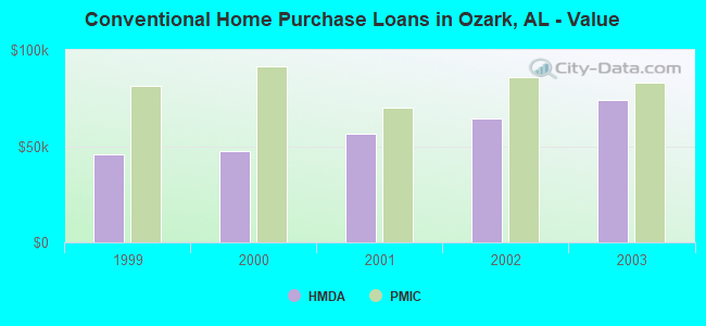
| Private Mortgage Insurance Companies Aggregated Statistics For Year 2003 (Based on 4 partial tracts) | ||||||
| A) Conventional Home Purchase Loans | B) Refinancings | C) Non-occupant Loans on < 5 Family Dwellings (A & B) | ||||
|---|---|---|---|---|---|---|
| Number | Average Value | Number | Average Value | Number | Average Value | |
| LOANS ORIGINATED | 27 | $83,121 | 51 | $88,972 | 9 | $48,789 |
| APPLICATIONS APPROVED, NOT ACCEPTED | 1 | $270,080 | 6 | $95,193 | 1 | $108,750 |
| APPLICATIONS DENIED | 0 | $0 | 2 | $64,450 | 1 | $33,560 |
| APPLICATIONS WITHDRAWN | 1 | $164,830 | 3 | $89,480 | 0 | $0 |
| FILES CLOSED FOR INCOMPLETENESS | 0 | $0 | 0 | $0 | 0 | $0 |
Detailed PMIC statistics for the following Tracts: 0204.00 , 0205.00, 0207.00, 0208.00
2004 - 2018 National Fire Incident Reporting System (NFIRS) incidents
- Fire incident types reported to NFIRS in Ozark, AL
- 28339.4%Outside Fires
- 26336.6%Structure Fires
- 11015.3%Mobile Property/Vehicle Fires
- 638.8%Other
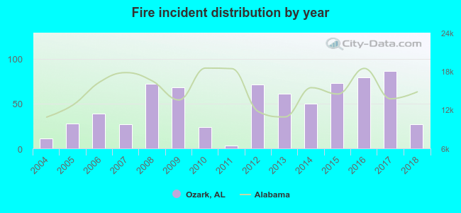 According to the data from the years 2004 - 2018 the average number of fire incidents per year is 48. The highest number of fires - 86 took place in 2017, and the least - 3 in 2011. The data has an increasing trend.
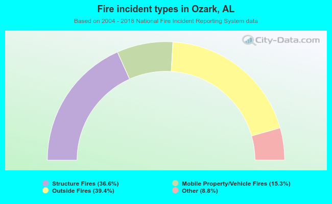 When looking into fire subcategories, the most reports belonged to: Outside Fires (39.4%), and Structure Fires (36.6%).
Fire-safe hotels and motels in Ozark, Alabama:
- Executive Inn and Suites, 858 US Hwy 231 N, Ozark, Alabama 36360 , Phone: (334) 774-7300
- Baymont Inn and Suites, 120 Hwy 231 S, Ozark, Alabama 36361 , Phone: (334) 774-0233
- Baymont Inn Of Ozark, 120 Hwy 231 S, Ozark, Alabama 36360 , Phone: (334) 774-0233, Fax: (334) 445-1900
- Microtel Inn & Suites, 1140 Hwy 231 N, Ozark, Alabama 36360 , Phone: (334) 774-2771, Fax: (334) 774-7877
- Hampton Inn, 235 N Us Hwy 231, Ozark, Alabama 36360 , Phone: (334) 443-6669, Fax: (334) 443-6670
- Quality Inn & Suites, 858 S Us Hwy 231, Ozark, Alabama 36360 , Phone: (334) 774-7300, Fax: (334) 774-1249
- Baymont Inn & Suites - Ozark, Al, 1360 S Us Hwy 231, Ozark, Alabama 36360 , Phone: (334) 774-0233, Fax: (334) 445-1900
| Most common first names in Ozark, AL among deceased individuals | ||
| Name | Count | Lived (average) |
|---|---|---|
| James | 210 | 71.7 years |
| Mary | 137 | 76.3 years |
| John | 132 | 73.6 years |
| William | 115 | 72.8 years |
| Willie | 103 | 71.8 years |
| Robert | 103 | 69.4 years |
| Annie | 78 | 77.5 years |
| Charles | 46 | 68.8 years |
| Joseph | 45 | 73.2 years |
| Lillie | 44 | 81.2 years |
| Most common last names in Ozark, AL among deceased individuals | ||
| Last name | Count | Lived (average) |
|---|---|---|
| Smith | 105 | 76.5 years |
| Johnson | 103 | 71.4 years |
| Williams | 71 | 71.3 years |
| Byrd | 59 | 76.3 years |
| Brown | 54 | 74.8 years |
| Andrews | 50 | 80.3 years |
| Mcleod | 50 | 72.7 years |
| Davis | 50 | 77.5 years |
| Martin | 48 | 74.2 years |
| Miller | 48 | 73.3 years |
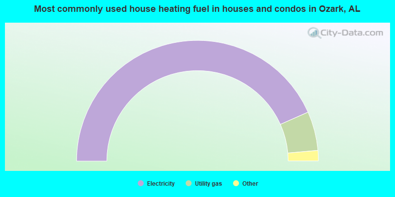
- 86.8%Electricity
- 10.5%Utility gas
- 1.8%Bottled, tank, or LP gas
- 0.6%No fuel used
- 0.3%Wood
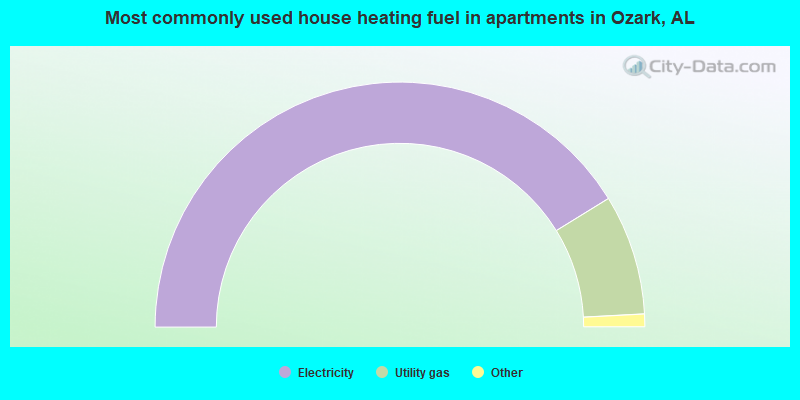
- 82.5%Electricity
- 15.9%Utility gas
- 0.8%No fuel used
- 0.8%Bottled, tank, or LP gas
Ozark compared to Alabama state average:
- Length of stay since moving in significantly above state average.
- Number of college students below state average.
Ozark on our top lists:
- #12 on the list of "Top 101 cities with largest percentage of males in occupations: installation, maintenance, and repair occupations (population 5,000+)"
- #33 on the list of "Top 101 cities with largest percentage of females in occupations: installation, maintenance, and repair occupations (population 5,000+)"
- #52 on the list of "Top 101 cities with largest percentage of males in industries: transportation and warehousing (population 5,000+)"
- #77 on the list of "Top 101 cities with the lowest cost per building permit(population 5,000+)"
- #14 on the list of "Top 101 counties with the highest percentage of residents relocating to foreign countries in 2011"
- #33 on the list of "Top 101 counties with the highest percentage of residents relocating to other counties in 2011"
- #45 on the list of "Top 101 counties with the highest percentage of residents relocating from other counties between 2010 and 2011"
- #50 on the list of "Top 101 counties with the highest percentage of residents relocating from foreign countries between 2010 and 2011"

|
Total of 5 patent applications in 2008-2024.