Please register to participate in our discussions with 2 million other members - it's free and quick! Some forums can only be seen by registered members. After you create your account, you'll be able to customize options and access all our 15,000 new posts/day with fewer ads.
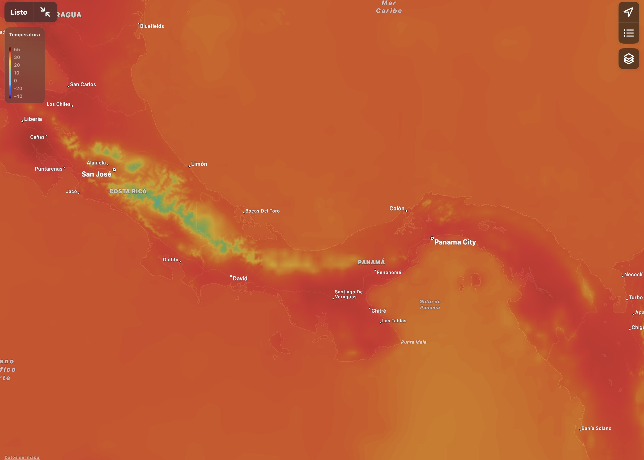
I guess a major difference between what is seen in the Caribbean islands vs Central America + Venezuela/Colombia isn’t just due to the mountains, but also to the trade winds which bathe the islands and doesn’t have the same effect on the isthmus or South America. Thank God for the mountains in Guatemala and Costa Rica.
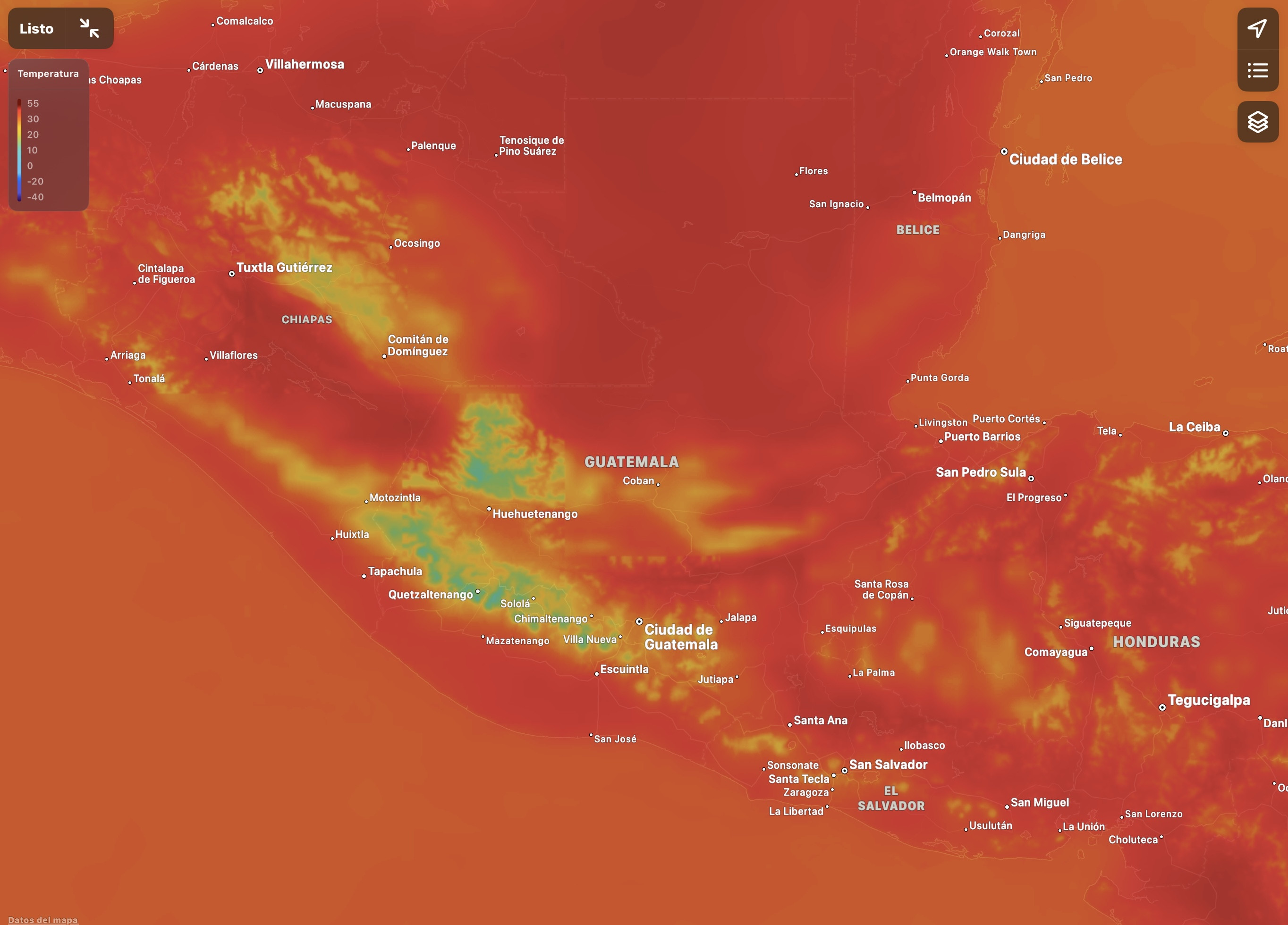
Those mountains in Guatemala make the difference!
No wonder most people in Costa Rica live in the central part of the country!
OMG! You might as well be on the surface of the sun in much of Venezuela and Colombia. Thank God for the Andes Mountains! Folks from the coasts of Colombia: “Hey, Paisas come on down!” Medellín folks; “thanks, but that’s ok. We are fine here!” Lol
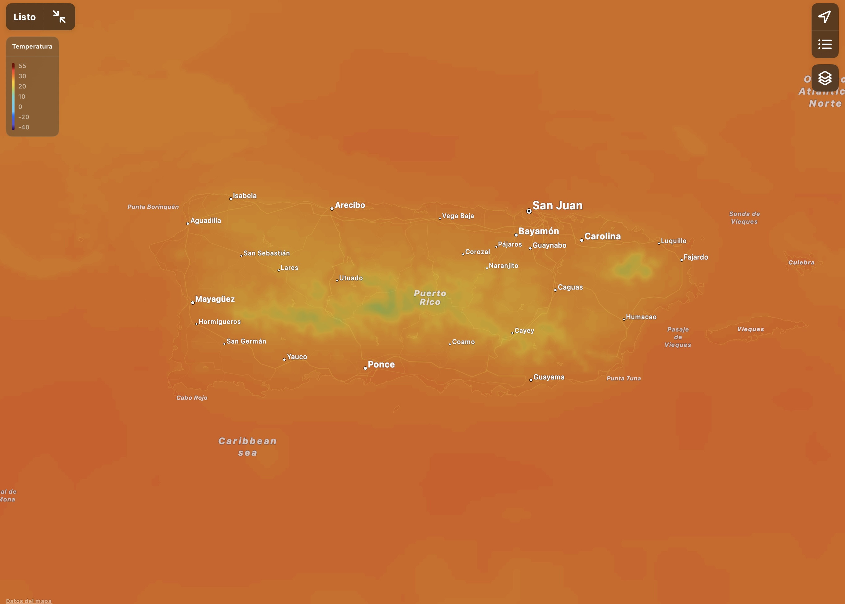
Cuba has the most land area with the hottest temps in the Caribbean and it never gets as red as seen in Central America and South America!
Jamaica a tropical island?
Hispaniola! Combining all the areas with the coolest weather in the Caribbean is probably as big as Puerto Rico and Jamaica combined. Even in the hotter valleys and coastal areas it doesn’t get as hot as in similar tropical places in Central America and northern South America.
March and April are the peak hottest months in most of Central America and the northern part of So. America. This is the dry season and there isn't much cloud cover. Look again at these temp maps in late May through late September and you will see temps are not much above 32C (90F) in most parts of the lower elevation areas. The big islands in the Caribbean at low elevations are going to have temperatures pretty close to sea surface temperature most of the year with the prevailing winds and surrounded by water.
March typically is the beginning of the warmer months. A more interesting comparison would be for the cool months: October through Jan/Feb., to see if there's a significant difference over the last 5 decades or so.
Looks to me like normal temperatures for those locations at this time, especially with this being an El Niño year.
.
Exactly. Even in the highlands (of Guatemala) it's searingly hot, though the maps show those areas as cooler. The elevation both mitigates the heat slighty, and intensifies the UV glare and proximity to the sun. I made the mistake once a long time ago of visiting the area in March. Never again!
Exactly. Even in the highlands (of Guatemala) it's searingly hot, though the maps show those areas as cooler. The elevation both mitigates the heat slighty, and intensifies the UV glare and proximity to the sun. I made the mistake once a long time ago of visiting the area in March. Never again!
The highlands of Guatemla are never really searingly hot. Along the coast yes it gets extememly hot, but not in the highlands. Current temprature in Quetzaltenango is only 17c/64f.
March and April are the peak hottest months in most of Central America and the northern part of So. America. This is the dry season and there isn't much cloud cover.
See below, though I don’t put in question the validity of what you say.
Quote:
Originally Posted by recycled
The big islands in the Caribbean at low elevations are going to have temperatures pretty close to sea surface temperature most of the year with the prevailing winds and surrounded by water.
Even during the height of summer when it’s definitely warmer and more humid in Santo Domingo (which is at sea level), Cartagena still feels hotter and more humid. In Puerto Plata, which is also near sea level, there as gushes of winds from sea and then from the mountain which feels like gushes of air condition air. It greatly helps tolerate better the heat. In Cartagena even the wind the warm. In a way Cartagena is like Orlando, Fl in the summer. In many areas of the DR it never feels like in Orlando, Fl during summer. In the summer time it actually feels hotter and more humid in Orlando, Fl than in the valleys and seaside areas of the DR and that’s despite both places are in their summer. The difference in how the wind feels is another difference, since in the DR it hardly ever feels like blowing hot air like it does in Orlando.
This was ahout now. Notice there isn’t much difference between temperatures and areas currently with rain. By what you claim, I think all areas under clouds and rain should have the same cooled temps, yet that isn’t the case.
Right now in places like the DR/Puerto Rico is around 1 pm and this is around the hottest part of the day. In the DR around 2pm or 3pm is like someone turns off a switch and it quickly gets cooler and more comfortable. In the major cities this transition nowadays is slower due to the city-island effect, but as soon you drive out of the Greater Santo Domingo with the windows down you feel that suddenly the temps drop, there is hardly a transition. In places like Cuba, Jamaica, much of Colombia is around noon. Further west from there in many areas is still morning.
This doesn’t takes inyo account the humidity which in the DR often feels smoother on the skin vs the more sticky kind felt in many other areas (such as in the eastern USA in summer.)
Current temps in the DR.
Notice the areas under rain fall, temps aren’t much different from other tropical areas in the country despite the cloud cover.
By comparison, look at the more intense red already seen in many areas of Colombia and Venezuela.
Right now there is more precipitation over areas of Colombia than Venezuela, but notice not much difference in temps.
Temps in Central America.
Precipitation in Central America.
As a rule of thumb, the heat and humidity feels worse on the continent than on the islands.
Exactly. Even in the highlands (of Guatemala) it's searingly hot, though the maps show those areas as cooler. The elevation both mitigates the heat slighty, and intensifies the UV glare and proximity to the sun. I made the mistake once a long time ago of visiting the area in March. Never again!
In the highlands and mountain areas the sun still remains strong (stronger than places further north at sea level or near it such as NYC or San Francisco, CA with the same temperatures), so sunblock is still necessary. The days are also brighter than in places further north with the same temperatures. However, the sun remains strong but you don’t feel it as strong as on the coast. In thag sense it can be deceptive, because you will burn at a cooler temperature that further north on the coast you will not burn. In fact, in NYC the sun never feels as strong as in the DR, even in the height of summer. But it never feels as hot up there as on the coast and the humidity never feels the same either. The wind feels so much fresher their than further down, even if on the coast the wind feels cooler than the standing air.
Please register to post and access all features of our very popular forum. It is free and quick. Over $68,000 in prizes has already been given out to active posters on our forum. Additional giveaways are planned.
Detailed information about all U.S. cities, counties, and zip codes on our site: City-data.com.

 Please register to participate in our discussions with 2 million other members - it's free and quick! Some forums can only be seen by registered members. After you create your account, you'll be able to customize options and access all our 15,000 new posts/day with fewer ads.