Bridge Statistics for St. Petersburg, Florida (FL)
Condition, Traffic, Stress, Structural Evaluation, Project Costs
- National Bridge Inventory (NBI) Statistics
- 336Number of bridges
- 8,323ft / 2,537mTotal length
- $3,470,000Total costs
- 6,864,859Total average daily traffic
- 387,824Total average daily truck traffic
- National Bridge Inventory (NBI) Registered Bridges for St. Petersburg
- No street view available for this location
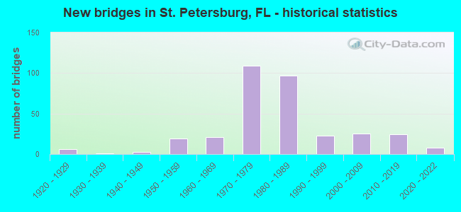
- New bridges - historical statistics
- 61920-1929
- 11930-1939
- 31940-1949
- 191950-1959
- 211960-1969
- 1091970-1979
- 971980-1989
- 231990-1999
- 252000-2009
- 242010-2019
- 82020-2022

- Reconstructed bridges - Historical Statistics
- 41980-1989
- 111990-1999
- 02000-2009
- 12010-2019


- Bridge Condition - Deck
- 11.5%Very good
- 68.2%Good
- 12.8%Satisfactory
- 4.1%Fair
- 2.7%Poor
- 0.7%Serious

- Bridge Condition - Superstructure
- 7.4%Very good
- 74.5%Good
- 7.4%Satisfactory
- 6.7%Fair
- 3.4%Poor
- 0.7%Serious

- Bridge Condition - Substructure
- 12.1%Very good
- 69.1%Good
- 14.1%Satisfactory
- 4.7%Fair

- Bridge Condition - Channel
- 14.4%Excellent
- 10.6%Very good
- 52.9%Good
- 20.2%Satisfactory
- 1.9%Fair
- 1.0%Poor

- Bridge Condition - Culverts
- 2.8%Very good
- 58.3%Good
- 22.2%Satisfactory
- 5.6%Fair
- 8.3%Poor
- 2.8%Serious
Find on map >> Show street view
Structure Number: 150014, Location: 0.25 Mi. S of I-275 (Lat: 27.895556, Lng: -82.639017), Route carried "on" structure: State highway 687, Year Built: 1959, Status: Open, Structure Length: 7.33m (24.05ft), Average Daily Traffic: 6,050 (year 2020), Truck Traffic: 6%, Average Future Daily Traffic: 10,497 (year 2042), Design Load: HS 20, Features Intersected: BIG ISLAND GAP
Minimum Vertical Clearance: 30.45m (99.90ft), Kilometerpoint: 8.784, Lanes on structure: 2, Owner: State Highway Agency, Approaching Roadway Width: 9.1m (29.9ft), Material/Design: Prestressed concrete, Design/Construction: Stringer/Multi-beam, Number Of Spans In Main Unit: 5, Length of Maximum Span: 14.7m (48.2ft), Curb-To-Curb Width: 8.6m (28.2ft), Out-to-Out Width: 10.5m (34.4ft)
Condition: Deck: Satisfactory, Superstructure: Good, Substructure: Good, Channel: Excellent, Operating Rating: 59.0 metric tons, Method Used To Determine Operating Rating: Allowable Stress (AS), Inventory Rating: 51.7 metric tons, Method Used To Determine Inventory Rating: Allowable Stress (AS), Structural Evaluation: Better than present minimum criteria, Deck Geometry: High priority of corrective action, Waterway Adequacy: Equal to present desirable criteria, Approach Roadway Alignment: Equal to present desirable criteria, Designated Inspection Frequency: Every 24 months, Underwater Inspection Frequency: Every 24 months, Inspection Date: April 2021, Underwater Inspection Date: March 2021, Deck Structure Type: Concrete Cast-file-Place
Find on map >> Show street view
Structure Number: 150024, Location: 20ft. N of 78th Ave N (Lat: 27.842881, Lng: -82.638717), Route carried "on" structure: US 92, Year Built: 1950, Status: Open, Structure Length: 1.54m (5.05ft), Average Daily Traffic: 32,000 (year 2020), Truck Traffic: 3%, Average Future Daily Traffic: 55,520 (year 2042), Design Load: H 15, Features Intersected: TURNER CREEK
Minimum Vertical Clearance: 30+ m (98+ ft), Kilometerpoint: 8.655, Lanes on structure: 7, Owner: State Highway Agency, Approaching Roadway Width: 26.1m (85.6ft), Skew: 20 degrees, Material/Design: Concrete, Design/Construction: Culvert, Number Of Spans In Main Unit: 4, Length of Maximum Span: 3.8m (12.5ft)
Condition: Channel: Good, Culverts: Satisfactory, Operating Rating: 62.3 metric tons, Method Used To Determine Operating Rating: Load Factor (LF), Inventory Rating: 37.4 metric tons, Method Used To Determine Inventory Rating: Load Factor (LF), Structural Evaluation: Equal to present minimum criteria, Waterway Adequacy: Equal to present desirable criteria, Approach Roadway Alignment: Equal to present desirable criteria, Designated Inspection Frequency: Every 24 months, Underwater Inspection Frequency: Every 24 months, Inspection Date: April 2021, Underwater Inspection Date: March 2021
Find on map >> Show street view
Structure Number: 150038, Location: 1.4MI N/O SUNSHINE SKYWAY (Lat: 27.661644, Lng: -82.677364), Route carried "on" structure: Interstate 275, Year Built: 1968, Year Reconstructed: 1990, Status: Open, Structure Length: 46.71m (153.25ft), Average Daily Traffic: 52,163 (year 2021), Truck Traffic: 15%, Average Future Daily Traffic: 90,503 (year 2042), Design Load: H 20, Features Intersected: BUNCES PASS
Minimum Vertical Clearance: 30.45m (99.90ft), Kilometerpoint: 9.093, Lanes on structure: 2, Base Highway Network: Yes, Toll: On Interstate toll segment, Owner: State Highway Agency, Approaching Roadway Width: 11.9m (39.0ft), Navigation Control: Yes ( Vertical Clearance: 5.7m (18.7ft), Horizontal Clearance: 17.2m (56.4ft)), Material/Design: Steel, Design/Construction: Stringer/Multi-beam, Number Of Spans In Main Unit: 1, Number Of Approach Spans: 40, Length of Maximum Span: 25.0m (82.0ft), Curb-To-Curb Width: 12.3m (40.4ft), Out-to-Out Width: 13.1m (43.0ft)
Condition: Deck: Satisfactory, Superstructure: Fair, Substructure: Fair, Channel: Good, Operating Rating: 36.6 metric tons, Method Used To Determine Operating Rating: Load and Resistance Factor (LRFR), Inventory Rating: 28.0 metric tons, Method Used To Determine Inventory Rating: Load and Resistance Factor (LRFR), Structural Evaluation: Somewhat better than minimum adequacy, Deck Geometry: Better than present minimum criteria, Waterway Adequacy: Equal to present desirable criteria, Approach Roadway Alignment: Equal to present desirable criteria, Length Of Structure Improvement: 46.40m (152.23ft), Designated Inspection Frequency: Every 24 months, Underwater Inspection Frequency: Every 24 months, Inspection Date: July 2021, Underwater Inspection Date: June 2021, Bridge Improvement Cost: $335,000, Roadway Improvement Cost: $40,000, Total Project Cost: $375,000, Deck Structure Type: Concrete Cast-file-Place, Wearing Surface/Protective System: Wearing Surface: Monolithic Concrete
Find on map >> Show street view
Structure Number: 150042, Location: 0.7MI NW OF SR-693 (Lat: 27.799222, Lng: -82.737567), Route carried "on" structure: Alternate US 19A, Year Built: 1957, Status: Open, Structure Length: 16.58m (54.40ft), Average Daily Traffic: 30,500 (year 2020), Truck Traffic: 3%, Average Future Daily Traffic: 52,918 (year 2042), Design Load: HS 20+Mod, Features Intersected: PINELLAS TRAIL, Facility Carried by Structure: ALT US-19 (SR-595)
Minimum Vertical Clearance: 30.45m (99.90ft), Kilometerpoint: 10.855, Lanes on structure: 4, Lanes under structure: 4, Base Highway Network: Yes, Owner: State Highway Agency, Approaching Roadway Width: 15.8m (51.8ft), Skew: 20 degrees, Material/Design: Steel continuous, Design/Construction: Stringer/Multi-beam, Number Of Spans In Main Unit: 9, Length of Maximum Span: 24.3m (79.7ft), Curb or Sidewalk Widths: Left: 0.6m (2.0ft), Right: 0.6m (2.0ft), Curb-To-Curb Width: 15.8m (51.8ft), Out-to-Out Width: 18.9m (62.0ft)
Condition: Deck: Satisfactory, Superstructure: Fair, Substructure: Satisfactory, Operating Rating: 64.5 metric tons, Method Used To Determine Operating Rating: Load Factor (LF), Inventory Rating: 38.6 metric tons, Method Used To Determine Inventory Rating: Load Factor (LF), Structural Evaluation: Somewhat better than minimum adequacy, Deck Geometry: Meets minimum limits, Underclear: Somewhat better than minimum adequacy, Approach Roadway Alignment: Equal to present desirable criteria, Designated Inspection Frequency: Every 24 months, Critical Feature Inspection Frequency: Every 12 months, Inspection Date: March 2020, Critical Feature Inspection Date: March 2021, Deck Structure Type: Concrete Cast-file-Place
Find on map >> Show street view
Structure Number: 150047, Location: At 54th Ave. N (Lat: 27.821114, Lng: -82.637739), Route carried "on" structure: US 92, Year Built: 1937, Status: Open, Structure Length: 0.98m (3.22ft), Average Daily Traffic: 32,000 (year 2020), Truck Traffic: 3%, Average Future Daily Traffic: 55,520 (year 2042), Design Load: H 15, Features Intersected: PLACIDO BAYOU
Minimum Vertical Clearance: 30+ m (98+ ft), Kilometerpoint: 7.878, Lanes on structure: 6, Owner: State Highway Agency, Approaching Roadway Width: 24.7m (81.0ft), Skew: 20 degrees, Material/Design: Concrete, Design/Construction: Culvert, Number Of Spans In Main Unit: 3, Length of Maximum Span: 3.4m (11.2ft)
Condition: Channel: Good, Culverts: Satisfactory, Inventory Rating: 54.8 metric tons, Method Used To Determine Inventory Rating: Load Factor (LF), Structural Evaluation: Equal to present minimum criteria, Waterway Adequacy: Equal to present desirable criteria, Approach Roadway Alignment: Equal to present desirable criteria, Designated Inspection Frequency: Every 24 months, Underwater Inspection Frequency: Every 24 months, Inspection Date: April 2021, Underwater Inspection Date: March 2021
Find on map >> Show street view
Structure Number: 150052, Location: 1.2MI. WEST OF US-19 (Lat: 27.717856, Lng: -82.698397), Route carried "on" structure: State highway 682, Year Built: 1962, Year Reconstructed: 1986, Status: Open, Structure Length: 19.70m (64.63ft), Average Daily Traffic: 13,750 (year 2020), Truck Traffic: 4%, Average Future Daily Traffic: 23,856 (year 2042), Design Load: H 20, Features Intersected: BOCA CIEGA BAY
Minimum Vertical Clearance: 30+ m (98+ ft), Kilometerpoint: 3.957, Lanes on structure: 2, Toll: On toll road, Owner: State Highway Agency, Approaching Roadway Width: 11.6m (38.1ft), Navigation Control: Yes ( Vertical Clearance: 5.4m (17.7ft), Horizontal Clearance: 21.0m (68.9ft)), Material/Design: Prestressed concrete, Design/Construction: Stringer/Multi-beam, Number Of Spans In Main Unit: 13, Length of Maximum Span: 22.0m (72.2ft), Curb or Sidewalk Widths: Left: 1.5m (4.9ft), Right: 0.0m, Curb-To-Curb Width: 12.0m (39.4ft), Out-to-Out Width: 14.6m (47.9ft)
Condition: Deck: Satisfactory, Superstructure: Good, Substructure: Satisfactory, Channel: Excellent, Operating Rating: 46.3 metric tons, Method Used To Determine Operating Rating: Allowable Stress (AS), Inventory Rating: 38.1 metric tons, Method Used To Determine Inventory Rating: Allowable Stress (AS), Structural Evaluation: Equal to present minimum criteria, Deck Geometry: Better than present minimum criteria, Waterway Adequacy: Equal to present desirable criteria, Approach Roadway Alignment: Equal to present desirable criteria, Designated Inspection Frequency: Every 24 months, Underwater Inspection Frequency: Every 24 months, Inspection Date: November 2021, Underwater Inspection Date: October 2021, Deck Structure Type: Concrete Cast-file-Place
Find on map >> Show street view
Structure Number: 150056, Location: 900FT S OF ULMERTON RD (Lat: 27.891272, Lng: -82.673456), Route carried "on" structure: State highway 686, Year Built: 1971, Status: Open, Structure Length: 0.82m (2.69ft), Average Daily Traffic: 4,500 (year 2020), Truck Traffic: 6%, Average Future Daily Traffic: 7,808 (year 2042), Design Load: HS 20+Mod, Features Intersected: MOSQUITO PASS
Minimum Vertical Clearance: 30+ m (98+ ft), Kilometerpoint: 12.946, Lanes on structure: 6, Owner: State Highway Agency, Approaching Roadway Width: 29.2m (95.8ft), Skew: 20 degrees, Material/Design: Concrete, Design/Construction: Culvert, Number Of Spans In Main Unit: 3, Length of Maximum Span: 2.7m (8.9ft)
Condition: Channel: Good, Culverts: Good, Structural Evaluation: Better than present minimum criteria, Waterway Adequacy: Equal to present desirable criteria, Approach Roadway Alignment: Equal to present desirable criteria, Designated Inspection Frequency: Every 24 months, Inspection Date: March 2020
Find on map >> Show street view
Structure Number: 150072, Location: 1.0 MI NORTH OF US-19A (Lat: 27.805303, Lng: -82.728650), Route carried "on" structure: State highway 693, Year Built: 1966, Status: Open, Structure Length: 2.41m (7.91ft), Average Daily Traffic: 41,000 (year 2020), Truck Traffic: 4%, Average Future Daily Traffic: 71,135 (year 2042), Design Load: HS 20+Mod, Features Intersected: LELLMANS CREEK
Minimum Vertical Clearance: 30+ m (98+ ft), Kilometerpoint: 4.921, Lanes on structure: 7, Base Highway Network: Yes, Owner: State Highway Agency, Approaching Roadway Width: 26.8m (87.9ft), Skew: 24 degrees, Material/Design: Concrete, Design/Construction: Culvert, Number Of Spans In Main Unit: 5, Length of Maximum Span: 4.6m (15.1ft)
Condition: Channel: Satisfactory, Culverts: Good, Operating Rating: 85.4 metric tons, Method Used To Determine Operating Rating: Load Factor (LF), Inventory Rating: 51.3 metric tons, Method Used To Determine Inventory Rating: Load Factor (LF), Structural Evaluation: Better than present minimum criteria, Waterway Adequacy: Equal to present desirable criteria, Approach Roadway Alignment: Equal to present desirable criteria, Designated Inspection Frequency: Every 24 months, Inspection Date: November 2021
Find on map >> Show street view
Structure Number: 150075, Location: I-275NB TO SR-686 WB RAMP (Lat: 27.878206, Lng: -82.658106), Route carried "on" structure: Ramp Interstate 275, Year Built: 1970, Year Reconstructed: 2010, Status: Open, Structure Length: 8.67m (28.44ft), Average Daily Traffic: 24,000 (year 2020), Truck Traffic: 6%, Average Future Daily Traffic: 41,640 (year 2042), Design Load: HS 20, Features Intersected: SR 686 (ROOSEVELT BLVD.), Facility Carried by Structure: RAMP P
Minimum Vertical Clearance: 30+ m (98+ ft), Kilometerpoint: 0.204, Lanes on structure: 2, Lanes under structure: 5, Owner: State Highway Agency, Approaching Roadway Width: 12.3m (40.4ft), Skew: 9 degrees, Material/Design: Prestressed concrete, Design/Construction: Stringer/Multi-beam, Number Of Spans In Main Unit: 4, Length of Maximum Span: 27.5m (90.2ft), Curb-To-Curb Width: 12.3m (40.4ft), Out-to-Out Width: 13.2m (43.3ft)
Condition: Deck: Good, Superstructure: Good, Substructure: Good, Operating Rating: 65.7 metric tons, Method Used To Determine Operating Rating: Load Factor (LF), Inventory Rating: 33.0 metric tons, Method Used To Determine Inventory Rating: Load Factor (LF), Structural Evaluation: Better than present minimum criteria, Deck Geometry: Superior to present desirable criteria, Underclear: Equal to present minimum criteria, Approach Roadway Alignment: Better than present minimum criteria, Designated Inspection Frequency: Every 24 months, Inspection Date: October 2021, Deck Structure Type: Concrete Cast-file-Place
Find on map >> Show street view
Structure Number: 150088, Location: 1.5 MI NORTH OF SR-595 (Lat: 27.799250, Lng: -82.662806), Route carried "on" structure: Interstate 275, Year Built: 1974, Status: Open, Structure Length: 5.34m (17.52ft), Average Daily Traffic: 72,750 (year 2020), Truck Traffic: 5%, Average Future Daily Traffic: 126,221 (year 2042), Design Load: HS 20+Mod, Features Intersected: 30TH AVE NORTH
Minimum Vertical Clearance: 30+ m (98+ ft), Kilometerpoint: 10.947, Lanes on structure: 3, Lanes under structure: 3, Base Highway Network: Yes, Owner: State Highway Agency, Approaching Roadway Width: 16.9m (55.4ft), Skew: 9 degrees, Material/Design: Prestressed concrete, Design/Construction: Stringer/Multi-beam, Number Of Spans In Main Unit: 3, Length of Maximum Span: 24.3m (79.7ft), Curb-To-Curb Width: 17.4m (57.1ft), Out-to-Out Width: 18.2m (59.7ft)
Condition: Deck: Good, Superstructure: Good, Substructure: Good, Operating Rating: 56.2 metric tons, Method Used To Determine Operating Rating: Load Factor (LF), Inventory Rating: 33.7 metric tons, Method Used To Determine Inventory Rating: Load Factor (LF), Structural Evaluation: Better than present minimum criteria, Deck Geometry: Better than present minimum criteria, Underclear: Superior to present desirable criteria, Approach Roadway Alignment: Equal to present desirable criteria, Designated Inspection Frequency: Every 24 months, Inspection Date: October 2021, Deck Structure Type: Concrete Cast-file-Place
Find on map >> Show street view
Structure Number: 150089, Location: 1.5MI NORTH OF SR-595 (Lat: 27.799250, Lng: -82.662528), Route carried "on" structure: Interstate 275, Year Built: 1974, Status: Open, Structure Length: 5.36m (17.59ft), Average Daily Traffic: 72,750 (year 2020), Truck Traffic: 5%, Average Future Daily Traffic: 126,221 (year 2042), Design Load: HS 20+Mod, Features Intersected: 30TH AVENUE NORTH
Minimum Vertical Clearance: 30+ m (98+ ft), Kilometerpoint: 10.947, Lanes on structure: 3, Lanes under structure: 2, Base Highway Network: Yes, Owner: State Highway Agency, Approaching Roadway Width: 17.6m (57.7ft), Skew: 9 degrees, Material/Design: Prestressed concrete, Design/Construction: Stringer/Multi-beam, Number Of Spans In Main Unit: 3, Length of Maximum Span: 23.0m (75.5ft), Curb-To-Curb Width: 17.4m (57.1ft), Out-to-Out Width: 18.3m (60.0ft)
Condition: Deck: Good, Superstructure: Good, Substructure: Good, Operating Rating: 56.2 metric tons, Method Used To Determine Operating Rating: Load Factor (LF), Inventory Rating: 33.7 metric tons, Method Used To Determine Inventory Rating: Load Factor (LF), Structural Evaluation: Better than present minimum criteria, Deck Geometry: Better than present minimum criteria, Underclear: Better than present minimum criteria, Approach Roadway Alignment: Equal to present desirable criteria, Designated Inspection Frequency: Every 24 months, Inspection Date: October 2021, Deck Structure Type: Concrete Cast-file-Place
Find on map >> Show street view
Structure Number: 15009, Location: 4.2 MI S OF GANDY BLVD. (Lat: 27.791967, Lng: -82.660697), Route carried "on" structure: Interstate 275, Year Built: 1974, Status: Open, Structure Length: 6.34m (20.80ft), Average Daily Traffic: 72,500 (year 2020), Truck Traffic: 6%, Average Future Daily Traffic: 125,788 (year 2042), Design Load: HL 93, Features Intersected: 22ND AVENUE NORTH
Minimum Vertical Clearance: 30+ m (98+ ft), Kilometerpoint: 10.102, Lanes on structure: 3, Lanes under structure: 8, Base Highway Network: Yes, Owner: State Highway Agency, Approaching Roadway Width: 17.4m (57.1ft), Material/Design: Steel, Design/Construction: Stringer/Multi-beam, Number Of Spans In Main Unit: 3, Length of Maximum Span: 39.6m (129.9ft), Curb-To-Curb Width: 17.0m (55.8ft), Out-to-Out Width: 18.1m (59.4ft)
Condition: Deck: Good, Superstructure: Good, Substructure: Good, Operating Rating: 52.9 metric tons, Method Used To Determine Operating Rating: Load and Resistance Factor (LRFR), Inventory Rating: 40.8 metric tons, Method Used To Determine Inventory Rating: Load and Resistance Factor (LRFR), Structural Evaluation: Better than present minimum criteria, Deck Geometry: Equal to present minimum criteria, Underclear: Equal to present minimum criteria, Approach Roadway Alignment: Equal to present desirable criteria, Designated Inspection Frequency: Every 24 months, Inspection Date: October 2021, Deck Structure Type: Concrete Cast-file-Place
Find on map >> Show street view
Structure Number: 150091, Location: 4.2MI S OF GANDY BLVD. (Lat: 27.791958, Lng: -82.660356), Route carried "on" structure: Interstate 275, Year Built: 1974, Status: Open, Structure Length: 6.34m (20.80ft), Average Daily Traffic: 72,500 (year 2020), Truck Traffic: 6%, Average Future Daily Traffic: 125,788 (year 2042), Design Load: HS 20+Mod, Features Intersected: 22ND AVE NORTH
Minimum Vertical Clearance: 30+ m (98+ ft), Kilometerpoint: 10.102, Lanes on structure: 3, Lanes under structure: 8, Base Highway Network: Yes, Owner: State Highway Agency, Approaching Roadway Width: 20.9m (68.6ft), Material/Design: Steel, Design/Construction: Stringer/Multi-beam, Number Of Spans In Main Unit: 3, Length of Maximum Span: 39.6m (129.9ft), Curb-To-Curb Width: 20.8m (68.2ft), Out-to-Out Width: 21.7m (71.2ft)
Condition: Deck: Good, Superstructure: Good, Substructure: Good, Operating Rating: 83.3 metric tons, Method Used To Determine Operating Rating: Load Factor (LF), Inventory Rating: 49.9 metric tons, Method Used To Determine Inventory Rating: Load Factor (LF), Structural Evaluation: Better than present minimum criteria, Deck Geometry: Superior to present desirable criteria, Underclear: Equal to present minimum criteria, Approach Roadway Alignment: Equal to present desirable criteria, Designated Inspection Frequency: Every 24 months, Inspection Date: October 2021, Deck Structure Type: Concrete Cast-file-Place
Find on map >> Show street view
Structure Number: 150092, Location: 3 MI S OF GANDY BLVD. (Lat: 27.806569, Lng: -82.662975), Route carried "on" structure: Interstate 275, Year Built: 1974, Status: Open, Structure Length: 6.18m (20.28ft), Average Daily Traffic: 72,750 (year 2020), Truck Traffic: 5%, Average Future Daily Traffic: 126,221 (year 2042), Design Load: HS 20+Mod, Features Intersected: 38TH AVENUE NORTH
Minimum Vertical Clearance: 30+ m (98+ ft), Kilometerpoint: 11.764, Lanes on structure: 3, Lanes under structure: 5, Base Highway Network: Yes, Owner: State Highway Agency, Approaching Roadway Width: 17.7m (58.1ft), Material/Design: Steel, Design/Construction: Stringer/Multi-beam, Number Of Spans In Main Unit: 3, Length of Maximum Span: 36.2m (118.8ft), Curb-To-Curb Width: 17.1m (56.1ft), Out-to-Out Width: 18.2m (59.7ft)
Condition: Deck: Good, Superstructure: Good, Substructure: Good, Operating Rating: 82.6 metric tons, Method Used To Determine Operating Rating: Load Factor (LF), Inventory Rating: 49.4 metric tons, Method Used To Determine Inventory Rating: Load Factor (LF), Structural Evaluation: Better than present minimum criteria, Deck Geometry: Equal to present minimum criteria, Underclear: Equal to present minimum criteria, Approach Roadway Alignment: Equal to present desirable criteria, Designated Inspection Frequency: Every 24 months, Inspection Date: October 2021, Deck Structure Type: Concrete Cast-file-Place
Find on map >> Show street view
Structure Number: 150093, Location: 3 MI S OF GANDY BLVD. (Lat: 27.806619, Lng: -82.662236), Route carried "on" structure: Interstate 275, Year Built: 1974, Status: Open, Structure Length: 6.69m (21.95ft), Average Daily Traffic: 72,750 (year 2020), Truck Traffic: 5%, Average Future Daily Traffic: 126,221 (year 2042), Design Load: HS 20+Mod, Features Intersected: 38TH AVENUE NORTH
Minimum Vertical Clearance: 30+ m (98+ ft), Kilometerpoint: 11.750, Lanes on structure: 3, Lanes under structure: 6, Base Highway Network: Yes, Owner: State Highway Agency, Approaching Roadway Width: 17.7m (58.1ft), Skew: 1 degrees, Material/Design: Steel, Design/Construction: Stringer/Multi-beam, Number Of Spans In Main Unit: 3, Length of Maximum Span: 36.2m (118.8ft), Curb-To-Curb Width: 17.1m (56.1ft), Out-to-Out Width: 18.2m (59.7ft)
Condition: Deck: Good, Superstructure: Good, Substructure: Good, Operating Rating: 81.4 metric tons, Method Used To Determine Operating Rating: Load Factor (LF), Inventory Rating: 48.7 metric tons, Method Used To Determine Inventory Rating: Load Factor (LF), Structural Evaluation: Better than present minimum criteria, Deck Geometry: Equal to present minimum criteria, Underclear: Equal to present minimum criteria, Approach Roadway Alignment: Equal to present desirable criteria, Designated Inspection Frequency: Every 24 months, Inspection Date: October 2021, Deck Structure Type: Concrete Cast-file-Place
Find on map >> Show street view
Structure Number: 150094, Location: 2.3 MI S OF GANDY BLVD (Lat: 27.817511, Lng: -82.664883), Route carried "on" structure: Interstate 275, Year Built: 1972, Status: Open, Structure Length: 4.75m (15.58ft), Average Daily Traffic: 69,250 (year 2020), Truck Traffic: 6%, Average Future Daily Traffic: 120,149 (year 2042), Design Load: HS 20+Mod, Features Intersected: 50TH AVE N SR-689
Minimum Vertical Clearance: 30+ m (98+ ft), Kilometerpoint: 13.018, Lanes on structure: 5, Lanes under structure: 4, Base Highway Network: Yes, Owner: State Highway Agency, Approaching Roadway Width: 23.5m (77.1ft), Material/Design: Prestressed concrete, Design/Construction: Stringer/Multi-beam, Number Of Spans In Main Unit: 3, Length of Maximum Span: 24.2m (79.4ft), Curb-To-Curb Width: 23.1m (75.8ft), Out-to-Out Width: 24.4m (80.1ft)
Condition: Deck: Good, Superstructure: Good, Substructure: Good, Operating Rating: 60.8 metric tons, Method Used To Determine Operating Rating: Allowable Stress (AS), Inventory Rating: 47.2 metric tons, Method Used To Determine Inventory Rating: Allowable Stress (AS), Structural Evaluation: Better than present minimum criteria, Deck Geometry: Somewhat better than minimum adequacy, Underclear: Equal to present minimum criteria, Approach Roadway Alignment: Equal to present desirable criteria, Designated Inspection Frequency: Every 24 months, Inspection Date: October 2021, Deck Structure Type: Concrete Cast-file-Place
Find on map >> Show street view
Structure Number: 150095, Location: 2.3 MI S OF GANDY BLVD (Lat: 27.817503, Lng: -82.664508), Route carried "on" structure: Interstate 275, Year Built: 1972, Status: Open, Structure Length: 4.75m (15.58ft), Average Daily Traffic: 69,250 (year 2020), Truck Traffic: 6%, Average Future Daily Traffic: 120,149 (year 2042), Design Load: HS 20+Mod, Features Intersected: 50TH AVE N SR-689
Minimum Vertical Clearance: 30+ m (98+ ft), Kilometerpoint: 13.018, Lanes on structure: 5, Lanes under structure: 4, Base Highway Network: Yes, Owner: State Highway Agency, Approaching Roadway Width: 23.5m (77.1ft), Material/Design: Prestressed concrete, Design/Construction: Stringer/Multi-beam, Number Of Spans In Main Unit: 3, Length of Maximum Span: 24.4m (80.1ft), Curb-To-Curb Width: 23.1m (75.8ft), Out-to-Out Width: 24.4m (80.1ft)
Condition: Deck: Good, Superstructure: Good, Substructure: Good, Operating Rating: 62.6 metric tons, Method Used To Determine Operating Rating: Allowable Stress (AS), Inventory Rating: 48.1 metric tons, Method Used To Determine Inventory Rating: Allowable Stress (AS), Structural Evaluation: Better than present minimum criteria, Deck Geometry: Somewhat better than minimum adequacy, Underclear: Better than present minimum criteria, Approach Roadway Alignment: Equal to present desirable criteria, Designated Inspection Frequency: Every 24 months, Inspection Date: October 2021, Deck Structure Type: Concrete Cast-file-Place
Find on map >> Show street view
Structure Number: 150096, Location: 2.1 MI S OF SR-694 (Lat: 27.821117, Lng: -82.664653), Route carried "on" structure: City street , Year Built: 1972, Status: Open, Structure Length: 9.07m (29.76ft), Average Daily Traffic: 18,000 (year 2020), Truck Traffic: 4%, Average Future Daily Traffic: 31,230 (year 2042), Design Load: HS 20+Mod, Features Intersected: I-275, Facility Carried by Structure: 54TH AVE NORTH
Minimum Vertical Clearance: 30+ m (98+ ft), Kilometerpoint: 1.423, Lanes on structure: 6, Lanes under structure: 8, Owner: State Highway Agency, Approaching Roadway Width: 29.1m (95.5ft), Skew: 20 degrees, Material/Design: Steel, Design/Construction: Stringer/Multi-beam, Number Of Spans In Main Unit: 4, Length of Maximum Span: 39.6m (129.9ft), Curb or Sidewalk Widths: Left: 1.5m (4.9ft), Right: 1.5m (4.9ft), Curb-To-Curb Width: 29.7m (97.4ft), Out-to-Out Width: 38.9m (127.6ft)
Condition: Deck: Good, Superstructure: Satisfactory, Substructure: Good, Inventory Rating: 56.4 metric tons, Method Used To Determine Inventory Rating: Load Factor (LF), Structural Evaluation: Equal to present minimum criteria, Deck Geometry: Superior to present desirable criteria, Underclear: Meets minimum limits, Approach Roadway Alignment: Equal to present desirable criteria, Designated Inspection Frequency: Every 24 months, Inspection Date: October 2021, Deck Structure Type: Concrete Cast-file-Place
Find on map >> Show street view
Structure Number: 150097, Location: 1.7MI S OF GANDY BLVD (Lat: 27.828383, Lng: -82.666789), Route carried "on" structure: Interstate 275, Year Built: 1972, Status: Open, Structure Length: 5.72m (18.77ft), Average Daily Traffic: 65,500 (year 2020), Truck Traffic: 6%, Average Future Daily Traffic: 113,642 (year 2042), Design Load: HS 20, Features Intersected: 62ND AVE NORTH
Minimum Vertical Clearance: 30+ m (98+ ft), Kilometerpoint: 14.246, Lanes on structure: 3, Lanes under structure: 4, Base Highway Network: Yes, Owner: State Highway Agency, Approaching Roadway Width: 17.2m (56.4ft), Material/Design: Prestressed concrete, Design/Construction: Stringer/Multi-beam, Number Of Spans In Main Unit: 3, Length of Maximum Span: 28.7m (94.2ft), Curb-To-Curb Width: 17.2m (56.4ft), Out-to-Out Width: 17.9m (58.7ft)
Condition: Deck: Good, Superstructure: Good, Substructure: Good, Operating Rating: 59.5 metric tons, Method Used To Determine Operating Rating: Load Factor (LF), Inventory Rating: 35.7 metric tons, Method Used To Determine Inventory Rating: Load Factor (LF), Structural Evaluation: Better than present minimum criteria, Deck Geometry: Better than present minimum criteria, Underclear: Better than present minimum criteria, Approach Roadway Alignment: Equal to present desirable criteria, Designated Inspection Frequency: Every 24 months, Inspection Date: October 2021, Deck Structure Type: Concrete Cast-file-Place
Find on map >> Show street view
Structure Number: 150098, Location: 1.7MI SOUTH OF GANDY BLVD (Lat: 27.828383, Lng: -82.666469), Route carried "on" structure: Interstate 275, Year Built: 1972, Status: Open, Structure Length: 5.72m (18.77ft), Average Daily Traffic: 65,500 (year 2020), Truck Traffic: 6%, Average Future Daily Traffic: 113,642 (year 2042), Design Load: HS 20, Features Intersected: 62ND AVE NORTH
Minimum Vertical Clearance: 30+ m (98+ ft), Kilometerpoint: 14.246, Lanes on structure: 3, Lanes under structure: 4, Base Highway Network: Yes, Owner: State Highway Agency, Approaching Roadway Width: 17.2m (56.4ft), Material/Design: Prestressed concrete, Design/Construction: Stringer/Multi-beam, Number Of Spans In Main Unit: 3, Length of Maximum Span: 28.7m (94.2ft), Curb-To-Curb Width: 17.2m (56.4ft), Out-to-Out Width: 17.9m (58.7ft)
Condition: Deck: Good, Superstructure: Good, Substructure: Good, Operating Rating: 59.5 metric tons, Method Used To Determine Operating Rating: Load Factor (LF), Inventory Rating: 35.7 metric tons, Method Used To Determine Inventory Rating: Load Factor (LF), Structural Evaluation: Better than present minimum criteria, Deck Geometry: Better than present minimum criteria, Underclear: Better than present minimum criteria, Approach Roadway Alignment: Equal to present desirable criteria, Designated Inspection Frequency: Every 24 months, Inspection Date: October 2021, Deck Structure Type: Concrete Cast-file-Place
Find on map >> Show street view
Structure Number: 150099, Location: 2 MI S OF SR-686 (Lat: 27.850536, Lng: -82.663817), Route carried "on" structure: Ramp State highway 694, Year Built: 1971, Status: Open, Structure Length: 9.94m (32.61ft), Average Daily Traffic: 9,800 (year 2020), Truck Traffic: 6%, Average Future Daily Traffic: 17,003 (year 2042), Design Load: HS 20+Mod, Features Intersected: I-275
Minimum Vertical Clearance: 30.45m (99.90ft), Kilometerpoint: 0.154, Lanes on structure: 2, Lanes under structure: 7, Owner: State Highway Agency, Approaching Roadway Width: 12.3m (40.4ft), Skew: 1 degrees, Material/Design: Prestressed concrete, Design/Construction: Stringer/Multi-beam, Number Of Spans In Main Unit: 4, Length of Maximum Span: 31.1m (102.0ft), Curb-To-Curb Width: 12.3m (40.4ft), Out-to-Out Width: 13.0m (42.7ft)
Condition: Deck: Good, Superstructure: Good, Substructure: Good, Operating Rating: 49.1 metric tons, Method Used To Determine Operating Rating: Load Factor (LF), Inventory Rating: 37.6 metric tons, Method Used To Determine Inventory Rating: Load Factor (LF), Structural Evaluation: Better than present minimum criteria, Deck Geometry: Superior to present desirable criteria, Underclear: Somewhat better than minimum adequacy, Approach Roadway Alignment: Better than present minimum criteria, Designated Inspection Frequency: Every 24 months, Inspection Date: April 2021, Deck Structure Type: Concrete Cast-file-Place
Find on map >> Show street view
Structure Number: 1501, Location: 2 MI SOUTH OF SR-686 (Lat: 27.852361, Lng: -82.664028), Route carried "on" structure: Interstate 275, Year Built: 1971, Status: Open, Structure Length: 9.59m (31.46ft), Average Daily Traffic: 65,500 (year 2020), Truck Traffic: 6%, Average Future Daily Traffic: 113,642 (year 2042), Design Load: HS 20+Mod, Features Intersected: SR-694 (GANDY BLVD.)
Minimum Vertical Clearance: 30+ m (98+ ft), Kilometerpoint: 16.932, Lanes on structure: 4, Lanes under structure: 6, Base Highway Network: Yes, Owner: State Highway Agency, Approaching Roadway Width: 20.1m (65.9ft), Skew: 2 degrees, Material/Design: Prestressed concrete, Design/Construction: Stringer/Multi-beam, Number Of Spans In Main Unit: 4, Length of Maximum Span: 33.5m (109.9ft), Curb-To-Curb Width: 19.5m (64.0ft), Out-to-Out Width: 20.6m (67.6ft)
Condition: Deck: Good, Superstructure: Good, Substructure: Good, Operating Rating: 65.5 metric tons, Method Used To Determine Operating Rating: Load Factor (LF), Inventory Rating: 39.3 metric tons, Method Used To Determine Inventory Rating: Load Factor (LF), Structural Evaluation: Better than present minimum criteria, Deck Geometry: Somewhat better than minimum adequacy, Underclear: Equal to present minimum criteria, Approach Roadway Alignment: Equal to present desirable criteria, Designated Inspection Frequency: Every 24 months, Inspection Date: October 2021, Deck Structure Type: Concrete Cast-file-Place
Find on map >> Show street view
Structure Number: 150101, Location: 2MI SOUTH OF SR-686 (Lat: 27.852453, Lng: -82.663697), Route carried "on" structure: Interstate 275, Year Built: 1971, Status: Open, Structure Length: 9.59m (31.46ft), Average Daily Traffic: 65,500 (year 2020), Truck Traffic: 6%, Average Future Daily Traffic: 113,642 (year 2042), Design Load: HS 20+Mod, Features Intersected: SR-694 (GANDY BLVD.)
Minimum Vertical Clearance: 30+ m (98+ ft), Kilometerpoint: 16.942, Lanes on structure: 3, Lanes under structure: 6, Base Highway Network: Yes, Owner: State Highway Agency, Approaching Roadway Width: 17.1m (56.1ft), Skew: 2 degrees, Material/Design: Prestressed concrete, Design/Construction: Stringer/Multi-beam, Number Of Spans In Main Unit: 4, Length of Maximum Span: 33.5m (109.9ft), Curb-To-Curb Width: 17.1m (56.1ft), Out-to-Out Width: 17.8m (58.4ft)
Condition: Deck: Good, Superstructure: Good, Substructure: Good, Operating Rating: 64.4 metric tons, Method Used To Determine Operating Rating: Load Factor (LF), Inventory Rating: 38.2 metric tons, Method Used To Determine Inventory Rating: Load Factor (LF), Structural Evaluation: Better than present minimum criteria, Deck Geometry: Equal to present minimum criteria, Underclear: Equal to present minimum criteria, Approach Roadway Alignment: Equal to present desirable criteria, Designated Inspection Frequency: Every 24 months, Inspection Date: October 2021, Deck Structure Type: Concrete Cast-file-Place
Find on map >> Show street view
Structure Number: 150102, Location: I-275 AND SR-686 (Lat: 27.878844, Lng: -82.659058), Route carried "on" structure: Interstate 275, Year Built: 1970, Year Reconstructed: 2001, Status: Open, Structure Length: 7.50m (24.61ft), Average Daily Traffic: 65,500 (year 2020), Truck Traffic: 6%, Average Future Daily Traffic: 113,642 (year 2042), Design Load: HS 20, Features Intersected: SR-686 (ROOSEVELT BLVD.)
Minimum Vertical Clearance: 30.45m (99.90ft), Kilometerpoint: 20.046, Lanes on structure: 3, Lanes under structure: 6, Base Highway Network: Yes, Owner: State Highway Agency, Approaching Roadway Width: 17.0m (55.8ft), Material/Design: Prestressed concrete, Design/Construction: Stringer/Multi-beam, Number Of Spans In Main Unit: 4, Length of Maximum Span: 26.7m (87.6ft), Curb-To-Curb Width: 17.0m (55.8ft), Out-to-Out Width: 18.0m (59.1ft)
Condition: Deck: Good, Superstructure: Good, Substructure: Good, Operating Rating: 46.4 metric tons, Method Used To Determine Operating Rating: Load and Resistance Factor (LRFR), Inventory Rating: 32.7 metric tons, Method Used To Determine Inventory Rating: Load and Resistance Factor (LRFR), Structural Evaluation: Better than present minimum criteria, Deck Geometry: Equal to present minimum criteria, Underclear: Equal to present minimum criteria, Approach Roadway Alignment: Equal to present desirable criteria, Designated Inspection Frequency: Every 24 months, Inspection Date: October 2021, Deck Structure Type: Concrete Cast-file-Place
Find on map >> Show street view
Structure Number: 150103, Location: I-275 AND SR-686 (Lat: 27.878694, Lng: -82.658917), Route carried "on" structure: Interstate 275, Year Built: 1970, Year Reconstructed: 2001, Status: Open, Structure Length: 7.52m (24.67ft), Average Daily Traffic: 65,500 (year 2020), Truck Traffic: 6%, Average Future Daily Traffic: 113,642 (year 2042), Design Load: HS 20, Features Intersected: SR-686 (ROOSEVELT BLVD.)
Minimum Vertical Clearance: 30+ m (98+ ft), Kilometerpoint: 20.046, Lanes on structure: 3, Lanes under structure: 6, Base Highway Network: Yes, Owner: State Highway Agency, Approaching Roadway Width: 17.3m (56.8ft), Material/Design: Prestressed concrete, Design/Construction: Stringer/Multi-beam, Number Of Spans In Main Unit: 4, Length of Maximum Span: 26.7m (87.6ft), Curb-To-Curb Width: 17.0m (55.8ft), Out-to-Out Width: 18.0m (59.1ft)
Condition: Deck: Good, Superstructure: Good, Substructure: Good, Operating Rating: 46.1 metric tons, Method Used To Determine Operating Rating: Load and Resistance Factor (LRFR), Inventory Rating: 32.7 metric tons, Method Used To Determine Inventory Rating: Load and Resistance Factor (LRFR), Structural Evaluation: Better than present minimum criteria, Deck Geometry: Equal to present minimum criteria, Underclear: Better than present minimum criteria, Approach Roadway Alignment: Equal to present desirable criteria, Designated Inspection Frequency: Every 24 months, Inspection Date: October 2021, Deck Structure Type: Concrete Cast-file-Place
Find on map >> Show street view
Structure Number: 150108, Location: 0.25 mi. S of I-275 (Lat: 27.895581, Lng: -82.638814), Route carried "on" structure: State highway 687, Year Built: 1959, Status: Open, Structure Length: 7.33m (24.05ft), Average Daily Traffic: 6,050 (year 2020), Truck Traffic: 6%, Average Future Daily Traffic: 10,497 (year 2042), Design Load: HS 20, Features Intersected: BIG ISLAND GAP
Minimum Vertical Clearance: 30+ m (98+ ft), Kilometerpoint: 8.784, Lanes on structure: 2, Owner: State Highway Agency, Approaching Roadway Width: 8.4m (27.6ft), Material/Design: Prestressed concrete, Design/Construction: Stringer/Multi-beam, Number Of Spans In Main Unit: 5, Length of Maximum Span: 14.7m (48.2ft), Curb-To-Curb Width: 8.6m (28.2ft), Out-to-Out Width: 10.5m (34.4ft)
Condition: Deck: Good, Superstructure: Good, Substructure: Good, Channel: Excellent, Operating Rating: 59.0 metric tons, Method Used To Determine Operating Rating: Allowable Stress (AS), Inventory Rating: 51.7 metric tons, Method Used To Determine Inventory Rating: Allowable Stress (AS), Structural Evaluation: Better than present minimum criteria, Deck Geometry: High priority of corrective action, Waterway Adequacy: Equal to present desirable criteria, Approach Roadway Alignment: Equal to present desirable criteria, Designated Inspection Frequency: Every 24 months, Underwater Inspection Frequency: Every 24 months, Inspection Date: April 2021, Underwater Inspection Date: March 2021, Deck Structure Type: Concrete Cast-file-Place
Find on map >> Show street view
Structure Number: 150109, Location: 2MI S OF SR-686 (Lat: 27.853150, Lng: -82.662006), Route carried "on" structure: Ramp State highway 694, Year Built: 1972, Status: Open, Structure Length: 9.24m (30.31ft), Average Daily Traffic: 9,800 (year 2020), Truck Traffic: 6%, Average Future Daily Traffic: 17,003 (year 2042), Design Load: HS 20+Mod, Features Intersected: SR-687 GANDY BLVD, Facility Carried by Structure: RAMP B
Minimum Vertical Clearance: 30.45m (99.90ft), Kilometerpoint: 0.550, Lanes on structure: 2, Lanes under structure: 6, Owner: State Highway Agency, Approaching Roadway Width: 12.3m (40.4ft), Material/Design: Prestressed concrete, Design/Construction: Stringer/Multi-beam, Number Of Spans In Main Unit: 4, Length of Maximum Span: 31.3m (102.7ft), Curb-To-Curb Width: 12.3m (40.4ft), Out-to-Out Width: 13.0m (42.7ft)
Condition: Deck: Satisfactory, Superstructure: Good, Substructure: Good, Operating Rating: 36.3 metric tons, Method Used To Determine Operating Rating: Load and Resistance Factor (LRFR), Inventory Rating: 32.7 metric tons, Method Used To Determine Inventory Rating: Load and Resistance Factor (LRFR), Structural Evaluation: Better than present minimum criteria, Deck Geometry: Superior to present desirable criteria, Underclear: Equal to present minimum criteria, Approach Roadway Alignment: Equal to present minimum criteria, Designated Inspection Frequency: Every 24 months, Inspection Date: April 2021, Deck Structure Type: Concrete Cast-file-Place
Find on map >> Show street view
Structure Number: 150115, Location: 0.3 MI. S OF 22ND AVE N (Lat: 27.786714, Lng: -82.661142), Route carried "on" structure: Interstate 275, Year Built: 1975, Status: Open, Structure Length: 14.06m (46.13ft), Average Daily Traffic: 72,500 (year 2020), Truck Traffic: 6%, Average Future Daily Traffic: 125,788 (year 2042), Design Load: HS 20+Mod, Features Intersected: CSX RR
Minimum Vertical Clearance: 30+ m (98+ ft), Kilometerpoint: 9.468, Lanes on structure: 4, Base Highway Network: Yes, Owner: State Highway Agency, Approaching Roadway Width: 21.3m (69.9ft), Skew: 9 degrees, Material/Design: Prestressed concrete, Design/Construction: Stringer/Multi-beam, Number Of Spans In Main Unit: 5, Length of Maximum Span: 31.1m (102.0ft), Curb-To-Curb Width: 20.7m (67.9ft), Out-to-Out Width: 21.7m (71.2ft)
Condition: Deck: Good, Superstructure: Good, Substructure: Good, Operating Rating: 62.6 metric tons, Method Used To Determine Operating Rating: Allowable Stress (AS), Inventory Rating: 52.6 metric tons, Method Used To Determine Inventory Rating: Allowable Stress (AS), Structural Evaluation: Better than present minimum criteria, Deck Geometry: Equal to present minimum criteria, Underclear: Meets minimum limits, Approach Roadway Alignment: Equal to present desirable criteria, Designated Inspection Frequency: Every 24 months, Inspection Date: October 2021, Deck Structure Type: Concrete Cast-file-Place
Find on map >> Show street view
Structure Number: 150116, Location: 0.3 MI. S OF 22ND AVE N (Lat: 27.786386, Lng: -82.660894), Route carried "on" structure: Interstate 275, Year Built: 1975, Status: Open, Structure Length: 14.06m (46.13ft), Average Daily Traffic: 72,500 (year 2020), Truck Traffic: 6%, Average Future Daily Traffic: 125,788 (year 2042), Design Load: HS 20+Mod, Features Intersected: CSX RR
Minimum Vertical Clearance: 30+ m (98+ ft), Kilometerpoint: 9.431, Lanes on structure: 4, Base Highway Network: Yes, Owner: State Highway Agency, Approaching Roadway Width: 21.3m (69.9ft), Skew: 9 degrees, Material/Design: Prestressed concrete, Design/Construction: Stringer/Multi-beam, Number Of Spans In Main Unit: 5, Length of Maximum Span: 31.1m (102.0ft), Curb-To-Curb Width: 20.7m (67.9ft), Out-to-Out Width: 21.7m (71.2ft)
Condition: Deck: Good, Superstructure: Good, Substructure: Good, Operating Rating: 64.4 metric tons, Method Used To Determine Operating Rating: Allowable Stress (AS), Inventory Rating: 55.3 metric tons, Method Used To Determine Inventory Rating: Allowable Stress (AS), Structural Evaluation: Better than present minimum criteria, Deck Geometry: Equal to present minimum criteria, Underclear: Meets minimum limits, Approach Roadway Alignment: Equal to present desirable criteria, Designated Inspection Frequency: Every 24 months, Inspection Date: October 2021, Deck Structure Type: Concrete Cast-file-Place
Find on map >> Show street view
Structure Number: 150117, Location: 0.3 MI. N OF SR595 5TH AV (Lat: 27.784678, Lng: -82.661764), Route carried "on" structure: Interstate 275, Year Built: 1975, Status: Open, Structure Length: 5.87m (19.26ft), Average Daily Traffic: 72,500 (year 2020), Truck Traffic: 6%, Average Future Daily Traffic: 125,788 (year 2042), Design Load: HS 20+Mod, Features Intersected: 13TH AVENUE NORTH
Minimum Vertical Clearance: 30+ m (98+ ft), Kilometerpoint: 9.289, Lanes on structure: 4, Lanes under structure: 2, Base Highway Network: Yes, Owner: State Highway Agency, Approaching Roadway Width: 21.3m (69.9ft), Material/Design: Prestressed concrete, Design/Construction: Stringer/Multi-beam, Number Of Spans In Main Unit: 3, Length of Maximum Span: 24.5m (80.4ft), Curb-To-Curb Width: 20.8m (68.2ft), Out-to-Out Width: 22.0m (72.2ft)
Condition: Deck: Good, Superstructure: Good, Substructure: Good, Operating Rating: 45.4 metric tons, Method Used To Determine Operating Rating: Allowable Stress (AS), Inventory Rating: 39.9 metric tons, Method Used To Determine Inventory Rating: Allowable Stress (AS), Structural Evaluation: Better than present minimum criteria, Deck Geometry: Equal to present minimum criteria, Underclear: Superior to present desirable criteria, Approach Roadway Alignment: Equal to present desirable criteria, Designated Inspection Frequency: Every 24 months, Inspection Date: October 2021, Deck Structure Type: Concrete Cast-file-Place
Find on map >> Show street view
Structure Number: 150118, Location: 0.3 MI. N OF SR595 5TH AV (Lat: 27.784639, Lng: -82.661389), Route carried "on" structure: Interstate 275, Year Built: 1975, Status: Open, Structure Length: 5.87m (19.26ft), Average Daily Traffic: 72,500 (year 2020), Truck Traffic: 6%, Average Future Daily Traffic: 125,788 (year 2042), Design Load: HS 20+Mod, Features Intersected: 13TH AVENUE NORTH
Minimum Vertical Clearance: 30+ m (98+ ft), Kilometerpoint: 9.284, Lanes on structure: 4, Lanes under structure: 2, Base Highway Network: Yes, Owner: State Highway Agency, Approaching Roadway Width: 21.3m (69.9ft), Material/Design: Prestressed concrete, Design/Construction: Stringer/Multi-beam, Number Of Spans In Main Unit: 3, Length of Maximum Span: 24.5m (80.4ft), Curb-To-Curb Width: 20.8m (68.2ft), Out-to-Out Width: 22.0m (72.2ft)
Condition: Deck: Good, Superstructure: Good, Substructure: Good, Operating Rating: 45.4 metric tons, Method Used To Determine Operating Rating: Allowable Stress (AS), Inventory Rating: 39.9 metric tons, Method Used To Determine Inventory Rating: Allowable Stress (AS), Structural Evaluation: Better than present minimum criteria, Deck Geometry: Equal to present minimum criteria, Underclear: Superior to present desirable criteria, Approach Roadway Alignment: Equal to present desirable criteria, Designated Inspection Frequency: Every 24 months, Inspection Date: October 2021, Deck Structure Type: Concrete Cast-file-Place
Find on map >> Show street view
Structure Number: 150119, Location: 0.2MI N OF SR595 5TH AV N (Lat: 27.781167, Lng: -82.661056), Route carried "on" structure: Interstate 275, Year Built: 1975, Status: Open, Structure Length: 4.94m (16.21ft), Average Daily Traffic: 72,500 (year 2020), Truck Traffic: 6%, Average Future Daily Traffic: 125,788 (year 2042), Design Load: HS 20+Mod, Features Intersected: 9TH AVENUE NORTH
Minimum Vertical Clearance: 30+ m (98+ ft), Kilometerpoint: 8.880, Lanes on structure: 5, Lanes under structure: 4, Base Highway Network: Yes, Owner: State Highway Agency, Approaching Roadway Width: 27.1m (88.9ft), Skew: 1 degrees, Material/Design: Prestressed concrete, Design/Construction: Stringer/Multi-beam, Number Of Spans In Main Unit: 3, Length of Maximum Span: 24.4m (80.1ft), Curb-To-Curb Width: 27.1m (88.9ft), Out-to-Out Width: 28.0m (91.9ft)
Condition: Deck: Good, Superstructure: Good, Substructure: Good, Operating Rating: 48.1 metric tons, Method Used To Determine Operating Rating: Allowable Stress (AS), Inventory Rating: 40.8 metric tons, Method Used To Determine Inventory Rating: Allowable Stress (AS), Structural Evaluation: Better than present minimum criteria, Deck Geometry: Superior to present desirable criteria, Underclear: Equal to present minimum criteria, Approach Roadway Alignment: Equal to present desirable criteria, Designated Inspection Frequency: Every 24 months, Inspection Date: October 2021, Deck Structure Type: Concrete Cast-file-Place
Find on map >> Show street view
Structure Number: 15012, Location: 0.2MI N OF SR595 5TH AV N (Lat: 27.781167, Lng: -82.660611), Route carried "on" structure: Interstate 275, Year Built: 1975, Status: Open, Structure Length: 5.05m (16.57ft), Average Daily Traffic: 72,500 (year 2020), Truck Traffic: 6%, Average Future Daily Traffic: 125,788 (year 2042), Design Load: HS 20+Mod, Features Intersected: 9TH AVENUE NORTH
Minimum Vertical Clearance: 30+ m (98+ ft), Kilometerpoint: 8.879, Lanes on structure: 5, Lanes under structure: 4, Base Highway Network: Yes, Owner: State Highway Agency, Approaching Roadway Width: 25.7m (84.3ft), Skew: 3 degrees, Material/Design: Prestressed concrete, Design/Construction: Stringer/Multi-beam, Number Of Spans In Main Unit: 3, Length of Maximum Span: 24.9m (81.7ft), Curb-To-Curb Width: 25.7m (84.3ft), Out-to-Out Width: 26.5m (86.9ft)
Condition: Deck: Good, Superstructure: Good, Substructure: Good, Operating Rating: 48.1 metric tons, Method Used To Determine Operating Rating: Allowable Stress (AS), Inventory Rating: 40.8 metric tons, Method Used To Determine Inventory Rating: Allowable Stress (AS), Structural Evaluation: Better than present minimum criteria, Deck Geometry: Better than present minimum criteria, Underclear: Better than present minimum criteria, Approach Roadway Alignment: Equal to present desirable criteria, Designated Inspection Frequency: Every 24 months, Inspection Date: October 2021, Deck Structure Type: Concrete Cast-file-Place
Find on map >> Show street view
Structure Number: 150121, Location: AT SR-595 (5TH AVE N) (Lat: 27.766511, Lng: -82.658911), Route carried "on" structure: Interstate 275, Year Built: 1980, Status: Open, Structure Length: 132.90m (436.02ft), Average Daily Traffic: 49,250 (year 2020), Truck Traffic: 6%, Average Future Daily Traffic: 85,449 (year 2042), Design Load: HS 20+Mod, Features Intersected: 5TH AVE N&S (SR-595)
Minimum Vertical Clearance: 5.49m (18.01ft), Kilometerpoint: 7.171, Lanes on structure: 3, Lanes under structure: 30, Base Highway Network: Yes, Owner: State Highway Agency, Approaching Roadway Width: 13.7m (44.9ft), Skew: 9 degrees, Material/Design: Prestressed concrete, Design/Construction: Stringer/Multi-beam, Number Of Spans In Main Unit: 45, Length of Maximum Span: 34.3m (112.5ft), Curb-To-Curb Width: 13.7m (44.9ft), Out-to-Out Width: 14.7m (48.2ft)
Condition: Deck: Good, Superstructure: Good, Substructure: Good, Operating Rating: 48.1 metric tons, Method Used To Determine Operating Rating: Allowable Stress (AS), Inventory Rating: 39.9 metric tons, Method Used To Determine Inventory Rating: Allowable Stress (AS), Structural Evaluation: Better than present minimum criteria, Deck Geometry: Meets minimum limits, Underclear: Meets minimum limits, Approach Roadway Alignment: Equal to present desirable criteria, Designated Inspection Frequency: Every 24 months, Inspection Date: May 2020, Deck Structure Type: Concrete Cast-file-Place
Find on map >> Show street view
Structure Number: 150122, Location: AT SR-595 (5TH AVE N) (Lat: 27.771944, Lng: -82.658028), Route carried "on" structure: Interstate 275, Year Built: 1980, Status: Open, Structure Length: 137.70m (451.77ft), Average Daily Traffic: 49,250 (year 2020), Truck Traffic: 6%, Average Future Daily Traffic: 85,449 (year 2042), Design Load: HS 20+Mod, Features Intersected: 5TH AVE N&S (SR-595)
Minimum Vertical Clearance: 5.36m (17.59ft), Kilometerpoint: 7.128, Lanes on structure: 3, Lanes under structure: 34, Base Highway Network: Yes, Owner: State Highway Agency, Approaching Roadway Width: 13.7m (44.9ft), Skew: 9 degrees, Material/Design: Steel continuous, Design/Construction: Stringer/Multi-beam, Number Of Spans In Main Unit: 3, Number Of Approach Spans: 40, Length of Maximum Span: 54.3m (178.1ft), Curb-To-Curb Width: 13.7m (44.9ft), Out-to-Out Width: 14.5m (47.6ft)
Condition: Deck: Good, Superstructure: Good, Substructure: Good, Operating Rating: 50.8 metric tons, Method Used To Determine Operating Rating: Load Factor (LF), Inventory Rating: 41.7 metric tons, Method Used To Determine Inventory Rating: Load Factor (LF), Structural Evaluation: Better than present minimum criteria, Deck Geometry: Meets minimum limits, Underclear: Somewhat better than minimum adequacy, Approach Roadway Alignment: Equal to present desirable criteria, Designated Inspection Frequency: Every 24 months, Inspection Date: May 2020, Deck Structure Type: Concrete Cast-file-Place
Find on map >> Show street view
Structure Number: 150123, Location: I-275 & I-375 INTERCHANGE (Lat: 27.775833, Lng: -82.657944), Route carried "on" structure: Ramp Interstate 275, Year Built: 1977, Status: Open, Structure Length: 30.79m (101.02ft), Average Daily Traffic: 4,300 (year 2020), Truck Traffic: 6%, Average Future Daily Traffic: 7,460 (year 2042), Design Load: HS 20+Mod, Features Intersected: ST PETE MAINT YARD
Minimum Vertical Clearance: 30+ m (98+ ft), Kilometerpoint: 0.000, Lanes on structure: 1, Owner: State Highway Agency, Approaching Roadway Width: 8.4m (27.6ft), Material/Design: Prestressed concrete, Design/Construction: Stringer/Multi-beam, Number Of Spans In Main Unit: 11, Length of Maximum Span: 30.2m (99.1ft), Curb-To-Curb Width: 8.4m (27.6ft), Out-to-Out Width: 9.2m (30.2ft)
Condition: Deck: Good, Superstructure: Good, Substructure: Good, Operating Rating: 61.7 metric tons, Method Used To Determine Operating Rating: Allowable Stress (AS), Inventory Rating: 51.7 metric tons, Method Used To Determine Inventory Rating: Allowable Stress (AS), Structural Evaluation: Better than present minimum criteria, Deck Geometry: Superior to present desirable criteria, Approach Roadway Alignment: Better than present minimum criteria, Designated Inspection Frequency: Every 24 months, Inspection Date: October 2021, Deck Structure Type: Concrete Cast-file-Place
Find on map >> Show street view
Structure Number: 150124, Location: I275SB AT I-375EB RAMP (Lat: 27.776806, Lng: -82.659667), Route carried "on" structure: Ramp Interstate 375, Year Built: 1977, Status: Open, Structure Length: 36.40m (119.42ft), Average Daily Traffic: 13,750 (year 2020), Truck Traffic: 3%, Average Future Daily Traffic: 23,856 (year 2042), Design Load: HS 20+Mod, Features Intersected: I275NB&ALT-19(5TH AVE N)
Minimum Vertical Clearance: 30+ m (98+ ft), Kilometerpoint: 0.103, Lanes on structure: 2, Lanes under structure: 11, Owner: State Highway Agency, Approaching Roadway Width: 11.6m (38.1ft), Skew: 9 degrees, Material/Design: Steel continuous, Design/Construction: Stringer/Multi-beam, Number Of Spans In Main Unit: 5, Number Of Approach Spans: 6, Length of Maximum Span: 47.5m (155.8ft), Curb-To-Curb Width: 12.3m (40.4ft), Out-to-Out Width: 13.0m (42.7ft)
Condition: Deck: Satisfactory, Superstructure: Satisfactory, Substructure: Satisfactory, Operating Rating: 51.7 metric tons, Method Used To Determine Operating Rating: Load Factor (LF), Inventory Rating: 43.5 metric tons, Method Used To Determine Inventory Rating: Load Factor (LF), Structural Evaluation: Equal to present minimum criteria, Deck Geometry: Superior to present desirable criteria, Underclear: High priority of corrective action, Approach Roadway Alignment: Better than present minimum criteria, Designated Inspection Frequency: Every 24 months, Critical Feature Inspection Frequency: Every 12 months, Inspection Date: November 2020, Critical Feature Inspection Date: November 2021, Deck Structure Type: Concrete Cast-file-Place
Find on map >> Show street view
Structure Number: 150128, Location: I375 AT ALT19 (5TH AVE N) (Lat: 27.777472, Lng: -82.658667), Route carried "on" structure: Ramp Interstate 375, Year Built: 1977, Status: Open, Structure Length: 15.10m (49.54ft), Average Daily Traffic: 13,750 (year 2020), Truck Traffic: 3%, Average Future Daily Traffic: 23,856 (year 2042), Design Load: HS 20+Mod, Features Intersected: ALT-19 (5TH AVE N)
Minimum Vertical Clearance: 30+ m (98+ ft), Kilometerpoint: 0.103, Lanes on structure: 2, Lanes under structure: 5, Owner: State Highway Agency, Approaching Roadway Width: 12.0m (39.4ft), Material/Design: Steel continuous, Design/Construction: Stringer/Multi-beam, Number Of Spans In Main Unit: 4, Length of Maximum Span: 54.0m (177.2ft), Curb-To-Curb Width: 12.0m (39.4ft), Out-to-Out Width: 13.0m (42.7ft)
Condition: Deck: Good, Superstructure: Good, Substructure: Good, Operating Rating: 71.7 metric tons, Method Used To Determine Operating Rating: Load Factor (LF), Inventory Rating: 43.5 metric tons, Method Used To Determine Inventory Rating: Load Factor (LF), Structural Evaluation: Better than present minimum criteria, Deck Geometry: Superior to present desirable criteria, Underclear: Superior to present desirable criteria, Approach Roadway Alignment: Better than present minimum criteria, Designated Inspection Frequency: Every 24 months, Critical Feature Inspection Frequency: Every 12 months, Inspection Date: November 2020, Critical Feature Inspection Date: November 2021, Deck Structure Type: Concrete Cast-file-Place
Find on map >> Show street view
Structure Number: 150129, Location: 0.3MI. SOUTH OF I-175 (Lat: 27.762444, Lng: -82.663028), Route carried "on" structure: Interstate 275, Year Built: 1979, Status: Open, Structure Length: 6.49m (21.29ft), Average Daily Traffic: 49,250 (year 2020), Truck Traffic: 6%, Average Future Daily Traffic: 85,449 (year 2042), Design Load: HS 20+Mod, Features Intersected: 22ND STREET SOUTH
Minimum Vertical Clearance: 30+ m (98+ ft), Kilometerpoint: 6.532, Lanes on structure: 3, Lanes under structure: 2, Base Highway Network: Yes, Owner: State Highway Agency, Approaching Roadway Width: 17.2m (56.4ft), Skew: 3 degrees, Material/Design: Prestressed concrete, Design/Construction: Stringer/Multi-beam, Number Of Spans In Main Unit: 3, Length of Maximum Span: 28.0m (91.9ft), Curb-To-Curb Width: 17.2m (56.4ft), Out-to-Out Width: 18.0m (59.1ft)
Condition: Deck: Good, Superstructure: Good, Substructure: Good, Operating Rating: 52.6 metric tons, Method Used To Determine Operating Rating: Load Factor (LF), Inventory Rating: 45.4 metric tons, Method Used To Determine Inventory Rating: Load Factor (LF), Structural Evaluation: Better than present minimum criteria, Deck Geometry: Better than present minimum criteria, Underclear: Better than present minimum criteria, Approach Roadway Alignment: Equal to present desirable criteria, Designated Inspection Frequency: Every 24 months, Inspection Date: October 2021, Deck Structure Type: Concrete Precast Panels
Find on map >> Show street view
Structure Number: 15013, Location: 0.3MI S OF I-175 (Lat: 27.762114, Lng: -82.663019), Route carried "on" structure: Interstate 275, Year Built: 1979, Status: Open, Structure Length: 6.46m (21.19ft), Average Daily Traffic: 49,250 (year 2020), Truck Traffic: 6%, Average Future Daily Traffic: 85,449 (year 2042), Design Load: HS 20+Mod, Features Intersected: 22ND STREET SOUTH
Minimum Vertical Clearance: 30+ m (98+ ft), Kilometerpoint: 6.518, Lanes on structure: 3, Lanes under structure: 2, Base Highway Network: Yes, Owner: State Highway Agency, Approaching Roadway Width: 17.2m (56.4ft), Skew: 3 degrees, Material/Design: Prestressed concrete, Design/Construction: Stringer/Multi-beam, Number Of Spans In Main Unit: 3, Length of Maximum Span: 27.7m (90.9ft), Curb-To-Curb Width: 17.2m (56.4ft), Out-to-Out Width: 18.0m (59.1ft)
Condition: Deck: Good, Superstructure: Good, Substructure: Good, Operating Rating: 52.6 metric tons, Method Used To Determine Operating Rating: Load Factor (LF), Inventory Rating: 45.4 metric tons, Method Used To Determine Inventory Rating: Load Factor (LF), Structural Evaluation: Better than present minimum criteria, Deck Geometry: Better than present minimum criteria, Underclear: Superior to present desirable criteria, Approach Roadway Alignment: Equal to present desirable criteria, Designated Inspection Frequency: Every 24 months, Inspection Date: October 2021, Deck Structure Type: Concrete Precast Panels
Find on map >> Show street view
Structure Number: 150131, Location: 0.7MI SOUTH OF I-175 (Lat: 27.760861, Lng: -82.671167), Route carried "on" structure: Interstate 275, Year Built: 1980, Status: Open, Structure Length: 6.67m (21.88ft), Average Daily Traffic: 46,500 (year 2020), Truck Traffic: 6%, Average Future Daily Traffic: 80,678 (year 2042), Design Load: HS 20+Mod, Features Intersected: 28TH STREET SOUTH
Minimum Vertical Clearance: 30+ m (98+ ft), Kilometerpoint: 5.697, Lanes on structure: 3, Lanes under structure: 4, Base Highway Network: Yes, Owner: State Highway Agency, Approaching Roadway Width: 17.1m (56.1ft), Skew: 3 degrees, Material/Design: Prestressed concrete, Design/Construction: Stringer/Multi-beam, Number Of Spans In Main Unit: 3, Length of Maximum Span: 32.0m (105.0ft), Curb-To-Curb Width: 17.2m (56.4ft), Out-to-Out Width: 18.0m (59.1ft)
Condition: Deck: Good, Superstructure: Good, Substructure: Good, Operating Rating: 70.8 metric tons, Method Used To Determine Operating Rating: Load Factor (LF), Inventory Rating: 47.2 metric tons, Method Used To Determine Inventory Rating: Load Factor (LF), Structural Evaluation: Better than present minimum criteria, Deck Geometry: Better than present minimum criteria, Underclear: Superior to present desirable criteria, Approach Roadway Alignment: Equal to present desirable criteria, Designated Inspection Frequency: Every 24 months, Inspection Date: October 2021, Deck Structure Type: Concrete Cast-file-Place
Find on map >> Show street view
Structure Number: 150132, Location: 0.7MI SOUTH OF I-175 (Lat: 27.760556, Lng: -82.671111), Route carried "on" structure: Interstate 275, Year Built: 1980, Status: Open, Structure Length: 6.88m (22.57ft), Average Daily Traffic: 46,500 (year 2020), Truck Traffic: 6%, Average Future Daily Traffic: 80,678 (year 2042), Design Load: HS 20+Mod, Features Intersected: 28TH STREET SOUTH
Minimum Vertical Clearance: 30+ m (98+ ft), Kilometerpoint: 5.678, Lanes on structure: 3, Lanes under structure: 4, Base Highway Network: Yes, Owner: State Highway Agency, Approaching Roadway Width: 17.1m (56.1ft), Skew: 3 degrees, Material/Design: Prestressed concrete, Design/Construction: Stringer/Multi-beam, Number Of Spans In Main Unit: 3, Length of Maximum Span: 33.1m (108.6ft), Curb-To-Curb Width: 17.2m (56.4ft), Out-to-Out Width: 18.0m (59.1ft)
Condition: Deck: Good, Superstructure: Good, Substructure: Good, Operating Rating: 68.9 metric tons, Method Used To Determine Operating Rating: Load Factor (LF), Inventory Rating: 37.2 metric tons, Method Used To Determine Inventory Rating: Load Factor (LF), Structural Evaluation: Better than present minimum criteria, Deck Geometry: Better than present minimum criteria, Underclear: Superior to present desirable criteria, Approach Roadway Alignment: Equal to present desirable criteria, Designated Inspection Frequency: Every 24 months, Inspection Date: October 2021, Deck Structure Type: Concrete Cast-file-Place
Find on map >> Show street view
Structure Number: 15014, Location: I-175 AT 16TH ST S (Lat: 27.766853, Lng: -82.657292), Route carried "on" structure: Ramp Interstate 175, Year Built: 1977, Status: Open, Structure Length: 59.50m (195.21ft), Average Daily Traffic: 6,700 (year 2020), Truck Traffic: 6%, Average Future Daily Traffic: 11,624 (year 2042), Design Load: HS 20+Mod, Features Intersected: 3RD,4TH,5TH AVE & 16 ST
Minimum Vertical Clearance: 4.91m (16.11ft), Kilometerpoint: 0.006, Lanes on structure: 2, Lanes under structure: 15, Owner: State Highway Agency, Approaching Roadway Width: 12.4m (40.7ft), Skew: 9 degrees, Material/Design: Steel continuous, Design/Construction: Stringer/Multi-beam, Number Of Spans In Main Unit: 3, Number Of Approach Spans: 16, Length of Maximum Span: 57.7m (189.3ft), Curb-To-Curb Width: 12.4m (40.7ft), Out-to-Out Width: 13.2m (43.3ft)
Condition: Deck: Good, Superstructure: Good, Substructure: Good, Operating Rating: 51.7 metric tons, Method Used To Determine Operating Rating: Load Factor (LF), Inventory Rating: 43.5 metric tons, Method Used To Determine Inventory Rating: Load Factor (LF), Structural Evaluation: Better than present minimum criteria, Deck Geometry: Somewhat better than minimum adequacy, Underclear: Better than present minimum criteria, Approach Roadway Alignment: Better than present minimum criteria, Designated Inspection Frequency: Every 24 months, Critical Feature Inspection Frequency: Every 12 months, Inspection Date: November 2020, Critical Feature Inspection Date: November 2021, Deck Structure Type: Concrete Cast-file-Place