Bridge Statistics for Redlands, California (CA)
Condition, Traffic, Stress, Structural Evaluation, Project Costs
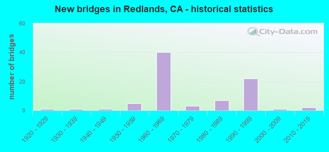
- New bridges - historical statistics
- 11920-1929
- 11930-1939
- 11940-1949
- 51950-1959
- 401960-1969
- 31970-1979
- 71980-1989
- 221990-1999
- 12000-2009
- 22010-2019

- Reconstructed bridges - Historical Statistics
- 11940-1949
- 11950-1959
- 01960-1969
- 11970-1979
- 21980-1989
- 61990-1999
- 112000-2009


- Bridge Condition - Deck
- 75.0%Good
- 22.5%Fair
- 2.5%Poor

- Bridge Condition - Superstructure
- 90.5%Good
- 9.5%Fair

- Bridge Condition - Substructure
- 95.2%Good
- 2.4%Fair
- 2.4%Poor

- Bridge Condition - Channel
- 13.0%Excellent
- 47.8%Very good
- 26.1%Good
- 4.3%Satisfactory
- 4.3%Fair
- 4.3%Serious

- Bridge Condition - Culverts
- 75.0%Good
- 25.0%Satisfactory
Find on map >> Show street view
Structure Number: 54 0472, Location: 08-SBD-010-31.52-RDL (Lat: 34.059264, Lng: -117.172839), Route carried "on" structure: Interstate 10, Year Built: 1962, Year Reconstructed: 2008, Status: Open, Structure Length: 13.29m (43.60ft), Average Daily Traffic: 172,000 (year 2017), Truck Traffic: 12%, Average Future Daily Traffic: 180,000 (year 2039), Design Load: HS 20, Features Intersected: BNSF RY SPUR, MILL CRK
Minimum Vertical Clearance: 5.64m (18.50ft), Kilometerpoint: 31.520, Lanes on structure: 8, Base Highway Network: Yes (, Subroute: 1), Owner: State Highway Agency, Approaching Roadway Width: 45.7m (149.9ft), Skew: 35 degrees, Material/Design: Concrete continuous, Design/Construction: Box Beam or Girders - Multiple, Number Of Spans In Main Unit: 5, Length of Maximum Span: 32.0m (105.0ft), Curb-To-Curb Width: 45.7m (149.9ft), Out-to-Out Width: 47.1m (154.5ft)
Condition: Deck: Good, Superstructure: Good, Substructure: Good, Channel: Good, Operating Rating: 54.1 metric tons, Method Used To Determine Operating Rating: Assigned rating based on Load Factor Design (LFD) reported in metric tons, Inventory Rating: 32.4 metric tons, Method Used To Determine Inventory Rating: Assigned rating based on Load Factor Design (LFD) reported in metric tons, Structural Evaluation: Better than present minimum criteria, Deck Geometry: Superior to present desirable criteria, Underclear: Meets minimum limits, Waterway Adequacy: Better than present minimum criteria, Approach Roadway Alignment: Equal to present desirable criteria, Designated Inspection Frequency: Every 24 months, Inspection Date: March 2020, Deck Structure Type: Concrete Cast-file-Place
Find on map >> Show street view
Structure Number: 54 057, Location: 08-SBD-010-27.64-LMLN (Lat: 34.066422, Lng: -117.237625), Route carried "on" structure: Interstate 10, Year Built: 1962, Year Reconstructed: 1990, Status: Open, Structure Length: 11.31m (37.11ft), Average Daily Traffic: 102,500 (year 2019), Truck Traffic: 12%, Average Future Daily Traffic: 123,000 (year 2041), Design Load: HS 20, Features Intersected: BNSF, MISSION STORM CHNL
Minimum Vertical Clearance: 5.97m (19.59ft), Kilometerpoint: 27.640, Lanes on structure: 10, Base Highway Network: Yes (, Subroute: 1), Owner: State Highway Agency, Approaching Roadway Width: 45.5m (149.3ft), Skew: 35 degrees, Material/Design: Concrete continuous, Design/Construction: Box Beam or Girders - Multiple, Number Of Spans In Main Unit: 4, Length of Maximum Span: 34.1m (111.9ft), Curb-To-Curb Width: 45.7m (149.9ft), Out-to-Out Width: 47.2m (154.9ft)
Condition: Deck: Good, Superstructure: Good, Substructure: Good, Channel: Good, Operating Rating: 34.7 metric tons, Method Used To Determine Operating Rating: Load and Resistance Factor Rating (LRFR) rating reported by rating factor(RF) method using HL-93 loadings, Inventory Rating: 26.6 metric tons, Method Used To Determine Inventory Rating: Load and Resistance Factor Rating (LRFR) rating reported by rating factor(RF) method using HL-93 loadings, Structural Evaluation: Equal to present minimum criteria, Deck Geometry: Superior to present desirable criteria, Underclear: Equal to present minimum criteria, Waterway Adequacy: Better than present minimum criteria, Approach Roadway Alignment: Equal to present desirable criteria, Designated Inspection Frequency: Every 24 months, Inspection Date: June 2021, Deck Structure Type: Concrete Cast-file-Place, Wearing Surface/Protective System: Wearing Surface: Integral Concrete
Find on map >> Show street view
Structure Number: 54 0578, Location: 08-SBD-010-31.41-RDL (Lat: 34.059903, Lng: -117.174117), Route carried "on" structure: Interstate 10, Year Built: 1962, Year Reconstructed: 2008, Status: Open, Structure Length: 5.64m (18.50ft), Average Daily Traffic: 157,000 (year 2014), Truck Traffic: 12%, Average Future Daily Traffic: 180,000 (year 2040), Design Load: HS 20, Features Intersected: CHURCH STREET
Minimum Vertical Clearance: 30+ m (98+ ft), Kilometerpoint: 31.410, Lanes on structure: 8, Lanes under structure: 2, Base Highway Network: Yes (, Subroute: 1), Owner: State Highway Agency, Approaching Roadway Width: 45.7m (149.9ft), Skew: 33 degrees, Material/Design: Concrete continuous, Design/Construction: Box Beam or Girders - Multiple, Number Of Spans In Main Unit: 3, Length of Maximum Span: 32.0m (105.0ft), Curb-To-Curb Width: 45.7m (149.9ft), Out-to-Out Width: 47.1m (154.5ft)
Condition: Deck: Good, Superstructure: Good, Substructure: Good, Operating Rating: 54.1 metric tons, Method Used To Determine Operating Rating: Assigned rating based on Load Factor Design (LFD) reported in metric tons, Inventory Rating: 32.4 metric tons, Method Used To Determine Inventory Rating: Assigned rating based on Load Factor Design (LFD) reported in metric tons, Structural Evaluation: Better than present minimum criteria, Deck Geometry: Superior to present desirable criteria, Underclear: Equal to present minimum criteria, Approach Roadway Alignment: Equal to present desirable criteria, Designated Inspection Frequency: Every 24 months, Inspection Date: March 2020, Deck Structure Type: Concrete Cast-file-Place
Find on map >> Show street view
Structure Number: 54 0579, Location: 08-SBD-010-31.01-RDL (Lat: 34.061606, Lng: -117.180592), Route carried "on" structure: Interstate 10, Year Built: 1962, Year Reconstructed: 2008, Status: Open, Structure Length: 4.39m (14.40ft), Average Daily Traffic: 157,000 (year 2014), Truck Traffic: 12%, Average Future Daily Traffic: 180,000 (year 2040), Design Load: HS 20+Mod, Features Intersected: STATE ROUTE 38 (6TH ST)
Minimum Vertical Clearance: 30+ m (98+ ft), Kilometerpoint: 31.010, Lanes on structure: 8, Lanes under structure: 3, Base Highway Network: Yes (, Subroute: 1), Owner: State Highway Agency, Approaching Roadway Width: 45.7m (149.9ft), Skew: 30 degrees, Material/Design: Concrete continuous, Design/Construction: Box Beam or Girders - Multiple, Number Of Spans In Main Unit: 3, Length of Maximum Span: 23.2m (76.1ft), Curb-To-Curb Width: 45.7m (149.9ft), Out-to-Out Width: 47.1m (154.5ft)
Condition: Deck: Good, Superstructure: Good, Substructure: Good, Operating Rating: 37.9 metric tons, Method Used To Determine Operating Rating: Load and Resistance Factor Rating (LRFR) rating reported by rating factor(RF) method using HL-93 loadings, Inventory Rating: 29.2 metric tons, Method Used To Determine Inventory Rating: Load and Resistance Factor Rating (LRFR) rating reported by rating factor(RF) method using HL-93 loadings, Structural Evaluation: Better than present minimum criteria, Deck Geometry: Superior to present desirable criteria, Underclear: Equal to present minimum criteria, Approach Roadway Alignment: Equal to present desirable criteria, Designated Inspection Frequency: Every 24 months, Inspection Date: March 2020, Deck Structure Type: Concrete Cast-file-Place
Find on map >> Show street view
Structure Number: 54 058, Location: 08-SBD-010-30.66-RDL (Lat: 34.061850, Lng: -117.186367), Route carried "on" structure: Interstate 10, Year Built: 1962, Year Reconstructed: 1990, Status: Open, Structure Length: 4.39m (14.40ft), Average Daily Traffic: 117,500 (year 2019), Truck Traffic: 12%, Average Future Daily Traffic: 141,000 (year 2041), Design Load: HS 20+Mod, Features Intersected: EUREKA STREET
Minimum Vertical Clearance: 30+ m (98+ ft), Kilometerpoint: 30.660, Lanes on structure: 11, Lanes under structure: 2, Base Highway Network: Yes (, Subroute: 1), Owner: State Highway Agency, Approaching Roadway Width: 56.1m (184.1ft), Skew: 30 degrees, Material/Design: Concrete continuous, Design/Construction: Box Beam or Girders - Multiple, Number Of Spans In Main Unit: 3, Length of Maximum Span: 23.2m (76.1ft), Curb-To-Curb Width: 56.1m (184.1ft), Out-to-Out Width: 57.8m (189.6ft)
Condition: Deck: Fair, Superstructure: Good, Substructure: Good, Operating Rating: 54.1 metric tons, Method Used To Determine Operating Rating: Assigned rating based on Load Factor Design (LFD) reported in metric tons, Inventory Rating: 32.4 metric tons, Method Used To Determine Inventory Rating: Assigned rating based on Load Factor Design (LFD) reported in metric tons, Structural Evaluation: Better than present minimum criteria, Deck Geometry: Superior to present desirable criteria, Underclear: Equal to present minimum criteria, Approach Roadway Alignment: Equal to present desirable criteria, Designated Inspection Frequency: Every 24 months, Inspection Date: June 2021, Deck Structure Type: Concrete Cast-file-Place, Wearing Surface/Protective System: Wearing Surface: Integral Concrete
Find on map >> Show street view
Structure Number: 54 0581, Location: 08-SBD-010-30.88-RDL (Lat: 34.061614, Lng: -117.182825), Route carried "on" structure: Interstate 10, Year Built: 1962, Year Reconstructed: 2008, Status: Open, Structure Length: 5.43m (17.81ft), Average Daily Traffic: 148,000 (year 2012), Truck Traffic: 11%, Average Future Daily Traffic: 180,000 (year 2040), Design Load: HS 20+Mod, Features Intersected: STATE ROUTE 38
Minimum Vertical Clearance: 30+ m (98+ ft), Kilometerpoint: 30.880, Lanes on structure: 9, Lanes under structure: 4, Base Highway Network: Yes (, Subroute: 1), Owner: State Highway Agency, Approaching Roadway Width: 52.1m (170.9ft), Skew: 30 degrees, Material/Design: Concrete continuous, Design/Construction: Box Beam or Girders - Multiple, Number Of Spans In Main Unit: 4, Length of Maximum Span: 15.5m (50.9ft), Curb-To-Curb Width: 52.1m (170.9ft), Out-to-Out Width: 53.5m (175.5ft)
Condition: Deck: Good, Superstructure: Good, Substructure: Good, Operating Rating: 54.1 metric tons, Method Used To Determine Operating Rating: Assigned rating based on Load Factor Design (LFD) reported in metric tons, Inventory Rating: 32.4 metric tons, Method Used To Determine Inventory Rating: Assigned rating based on Load Factor Design (LFD) reported in metric tons, Structural Evaluation: Better than present minimum criteria, Deck Geometry: Superior to present desirable criteria, Underclear: Equal to present minimum criteria, Approach Roadway Alignment: Equal to present desirable criteria, Designated Inspection Frequency: Every 24 months, Inspection Date: March 2020, Deck Structure Type: Concrete Cast-file-Place
Find on map >> Show street view
Structure Number: 54 0582, Location: 08-SBD-010-31.87-RDL (Lat: 34.056417, Lng: -117.167097), Route carried "on" structure: Interstate 10, Year Built: 1962, Year Reconstructed: 2008, Status: Open, Structure Length: 5.64m (18.50ft), Average Daily Traffic: 134,000 (year 2014), Truck Traffic: 12%, Average Future Daily Traffic: 180,000 (year 2040), Design Load: HS 20, Features Intersected: UNIVERSITY STREET
Minimum Vertical Clearance: 30+ m (98+ ft), Kilometerpoint: 31.870, Lanes on structure: 8, Lanes under structure: 4, Base Highway Network: Yes (, Subroute: 1), Owner: State Highway Agency, Approaching Roadway Width: 45.7m (149.9ft), Skew: 33 degrees, Material/Design: Concrete continuous, Design/Construction: Box Beam or Girders - Multiple, Number Of Spans In Main Unit: 3, Length of Maximum Span: 32.0m (105.0ft), Curb-To-Curb Width: 45.7m (149.9ft), Out-to-Out Width: 47.1m (154.5ft)
Condition: Deck: Good, Superstructure: Good, Substructure: Good, Operating Rating: 54.1 metric tons, Method Used To Determine Operating Rating: Assigned rating based on Load Factor Design (LFD) reported in metric tons, Inventory Rating: 32.4 metric tons, Method Used To Determine Inventory Rating: Assigned rating based on Load Factor Design (LFD) reported in metric tons, Structural Evaluation: Better than present minimum criteria, Deck Geometry: Superior to present desirable criteria, Underclear: Equal to present minimum criteria, Approach Roadway Alignment: Equal to present desirable criteria, Designated Inspection Frequency: Every 24 months, Inspection Date: March 2020, Deck Structure Type: Concrete Cast-file-Place
Find on map >> Show street view
Structure Number: 54 0583, Location: 08-SBD-010-30.38-RDL (Lat: 34.061592, Lng: -117.191664), Route carried "on" structure: Interstate 10, Year Built: 1962, Year Reconstructed: 1990, Status: Open, Structure Length: 4.97m (16.31ft), Average Daily Traffic: 111,000 (year 2019), Truck Traffic: 13%, Average Future Daily Traffic: 133,200 (year 2041), Design Load: HS 20+Mod, Features Intersected: TEXAS STREET
Minimum Vertical Clearance: 30+ m (98+ ft), Kilometerpoint: 30.380, Lanes on structure: 10, Lanes under structure: 4, Base Highway Network: Yes (, Subroute: 1), Owner: State Highway Agency, Approaching Roadway Width: 52.4m (171.9ft), Skew: 30 degrees, Material/Design: Concrete continuous, Design/Construction: Box Beam or Girders - Multiple, Number Of Spans In Main Unit: 3, Length of Maximum Span: 27.1m (88.9ft), Curb-To-Curb Width: 52.4m (171.9ft), Out-to-Out Width: 54.3m (178.1ft)
Condition: Deck: Good, Superstructure: Good, Substructure: Good, Operating Rating: 54.1 metric tons, Method Used To Determine Operating Rating: Assigned rating based on Load Factor Design (LFD) reported in metric tons, Inventory Rating: 32.4 metric tons, Method Used To Determine Inventory Rating: Assigned rating based on Load Factor Design (LFD) reported in metric tons, Structural Evaluation: Better than present minimum criteria, Deck Geometry: Superior to present desirable criteria, Underclear: Somewhat better than minimum adequacy, Approach Roadway Alignment: Equal to present desirable criteria, Designated Inspection Frequency: Every 24 months, Inspection Date: June 2021, Deck Structure Type: Concrete Cast-file-Place, Wearing Surface/Protective System: Wearing Surface: Integral Concrete
Find on map >> Show street view
Structure Number: 54 0584, Location: 08-SBD-010-31.99-RDL (Lat: 34.055794, Lng: -117.165864), Route carried "on" structure: Interstate 10, Year Built: 1962, Year Reconstructed: 2008, Status: Open, Structure Length: 7.89m (25.89ft), Average Daily Traffic: 134,000 (year 2014), Truck Traffic: 12%, Average Future Daily Traffic: 190,000 (year 2040), Design Load: HS 20, Features Intersected: CITRUS AVENUE
Minimum Vertical Clearance: 30+ m (98+ ft), Kilometerpoint: 31.990, Lanes on structure: 8, Lanes under structure: 4, Base Highway Network: Yes (, Subroute: 1), Owner: State Highway Agency, Approaching Roadway Width: 45.7m (149.9ft), Skew: 35 degrees, Material/Design: Concrete continuous, Design/Construction: Box Beam or Girders - Multiple, Number Of Spans In Main Unit: 3, Length of Maximum Span: 46.6m (152.9ft), Curb-To-Curb Width: 45.7m (149.9ft), Out-to-Out Width: 47.1m (154.5ft)
Condition: Deck: Good, Superstructure: Good, Substructure: Good, Operating Rating: 54.1 metric tons, Method Used To Determine Operating Rating: Assigned rating based on Load Factor Design (LFD) reported in metric tons, Inventory Rating: 32.4 metric tons, Method Used To Determine Inventory Rating: Assigned rating based on Load Factor Design (LFD) reported in metric tons, Structural Evaluation: Better than present minimum criteria, Deck Geometry: Superior to present desirable criteria, Underclear: Equal to present minimum criteria, Approach Roadway Alignment: Equal to present desirable criteria, Designated Inspection Frequency: Every 24 months, Inspection Date: March 2020, Deck Structure Type: Concrete Cast-file-Place
Find on map >> Show street view
Structure Number: 54 0585, Location: 08-SBD-010-32.11-RDL (Lat: 34.054567, Lng: -117.163958), Route carried "on" structure: Interstate 10, Year Built: 1962, Year Reconstructed: 2008, Status: Open, Structure Length: 5.03m (16.50ft), Average Daily Traffic: 136,000 (year 2012), Truck Traffic: 13%, Average Future Daily Traffic: 190,000 (year 2040), Design Load: HS 20, Features Intersected: CYPRESS AVENUE
Minimum Vertical Clearance: 30+ m (98+ ft), Kilometerpoint: 32.110, Lanes on structure: 8, Lanes under structure: 2, Base Highway Network: Yes (, Subroute: 1), Owner: State Highway Agency, Approaching Roadway Width: 45.7m (149.9ft), Skew: 31 degrees, Material/Design: Concrete continuous, Design/Construction: Box Beam or Girders - Multiple, Number Of Spans In Main Unit: 3, Length of Maximum Span: 27.7m (90.9ft), Curb-To-Curb Width: 45.7m (149.9ft), Out-to-Out Width: 47.4m (155.5ft)
Condition: Deck: Good, Superstructure: Good, Substructure: Good, Operating Rating: 54.1 metric tons, Method Used To Determine Operating Rating: Assigned rating based on Load Factor Design (LFD) reported in metric tons, Inventory Rating: 32.4 metric tons, Method Used To Determine Inventory Rating: Assigned rating based on Load Factor Design (LFD) reported in metric tons, Structural Evaluation: Better than present minimum criteria, Deck Geometry: Superior to present desirable criteria, Underclear: Equal to present minimum criteria, Approach Roadway Alignment: Equal to present desirable criteria, Designated Inspection Frequency: Every 24 months, Inspection Date: March 2020, Deck Structure Type: Concrete Cast-file-Place
Find on map >> Show street view
Structure Number: 54 0586, Location: 08-SBD-010-32.36-RDL (Lat: 34.051653, Lng: -117.161311), Route carried "on" structure: Interstate 10, Year Built: 1962, Year Reconstructed: 2008, Status: Open, Structure Length: 4.39m (14.40ft), Average Daily Traffic: 138,000 (year 2014), Truck Traffic: 12%, Average Future Daily Traffic: 190,000 (year 2040), Design Load: HS 20+Mod, Features Intersected: PALM AVE
Minimum Vertical Clearance: 30+ m (98+ ft), Kilometerpoint: 32.360, Lanes on structure: 8, Lanes under structure: 2, Base Highway Network: Yes (, Subroute: 1), Owner: State Highway Agency, Approaching Roadway Width: 46.7m (153.2ft), Skew: 30 degrees, Material/Design: Concrete continuous, Design/Construction: Box Beam or Girders - Multiple, Number Of Spans In Main Unit: 3, Length of Maximum Span: 23.2m (76.1ft), Curb-To-Curb Width: 46.7m (153.2ft), Out-to-Out Width: 48.2m (158.1ft)
Condition: Deck: Good, Superstructure: Good, Substructure: Good, Operating Rating: 54.1 metric tons, Method Used To Determine Operating Rating: Assigned rating based on Load Factor Design (LFD) reported in metric tons, Inventory Rating: 32.4 metric tons, Method Used To Determine Inventory Rating: Assigned rating based on Load Factor Design (LFD) reported in metric tons, Structural Evaluation: Better than present minimum criteria, Deck Geometry: Superior to present desirable criteria, Underclear: Better than present minimum criteria, Approach Roadway Alignment: Equal to present desirable criteria, Designated Inspection Frequency: Every 24 months, Inspection Date: March 2020, Deck Structure Type: Concrete Cast-file-Place
Find on map >> Show street view
Structure Number: 54 0587, Location: 08-SBD-010-32.61-RDL (Lat: 34.048611, Lng: -117.158953), Route carried "on" structure: Interstate 10, Year Built: 1962, Year Reconstructed: 2008, Status: Open, Structure Length: 4.39m (14.40ft), Average Daily Traffic: 138,000 (year 2014), Truck Traffic: 12%, Average Future Daily Traffic: 190,000 (year 2040), Design Load: HS 20+Mod, Features Intersected: HIGHLAND AVE
Minimum Vertical Clearance: 30+ m (98+ ft), Kilometerpoint: 32.610, Lanes on structure: 8, Lanes under structure: 2, Base Highway Network: Yes (, Subroute: 1), Owner: State Highway Agency, Approaching Roadway Width: 45.5m (149.3ft), Skew: 30 degrees, Material/Design: Concrete continuous, Design/Construction: Box Beam or Girders - Multiple, Number Of Spans In Main Unit: 3, Length of Maximum Span: 23.2m (76.1ft), Curb-To-Curb Width: 45.5m (149.3ft), Out-to-Out Width: 47.1m (154.5ft)
Condition: Deck: Good, Superstructure: Good, Substructure: Good, Operating Rating: 54.1 metric tons, Method Used To Determine Operating Rating: Assigned rating based on Load Factor Design (LFD) reported in metric tons, Inventory Rating: 32.4 metric tons, Method Used To Determine Inventory Rating: Assigned rating based on Load Factor Design (LFD) reported in metric tons, Structural Evaluation: Better than present minimum criteria, Deck Geometry: Superior to present desirable criteria, Underclear: Equal to present minimum criteria, Approach Roadway Alignment: Equal to present desirable criteria, Designated Inspection Frequency: Every 24 months, Inspection Date: March 2020, Deck Structure Type: Concrete Cast-file-Place
Find on map >> Show street view
Structure Number: 54 0588, Location: 08-SBD-010-33.13-RDL (Lat: 34.041558, Lng: -117.155736), Route carried "on" structure: Interstate 10, Year Built: 1962, Year Reconstructed: 2008, Status: Open, Structure Length: 4.66m (15.29ft), Average Daily Traffic: 147,000 (year 2018), Truck Traffic: 16%, Average Future Daily Traffic: 178,529 (year 2040), Design Load: HS 20+Mod, Features Intersected: FORD STREET
Minimum Vertical Clearance: 30+ m (98+ ft), Kilometerpoint: 33.130, Lanes on structure: 8, Lanes under structure: 3, Base Highway Network: Yes (, Subroute: 1), Owner: State Highway Agency, Approaching Roadway Width: 45.4m (149.0ft), Skew: 32 degrees, Material/Design: Concrete continuous, Design/Construction: Box Beam or Girders - Multiple, Number Of Spans In Main Unit: 3, Length of Maximum Span: 25.9m (85.0ft), Curb-To-Curb Width: 45.4m (149.0ft), Out-to-Out Width: 47.1m (154.5ft)
Condition: Deck: Good, Superstructure: Good, Substructure: Good, Operating Rating: 42.8 metric tons, Method Used To Determine Operating Rating: Load and Resistance Factor Rating (LRFR) rating reported by rating factor(RF) method using HL-93 loadings, Inventory Rating: 33.0 metric tons, Method Used To Determine Inventory Rating: Load and Resistance Factor Rating (LRFR) rating reported by rating factor(RF) method using HL-93 loadings, Structural Evaluation: Better than present minimum criteria, Deck Geometry: Superior to present desirable criteria, Underclear: Equal to present minimum criteria, Approach Roadway Alignment: Equal to present desirable criteria, Designated Inspection Frequency: Every 24 months, Inspection Date: March 2020, Deck Structure Type: Concrete Cast-file-Place
Find on map >> Show street view
Structure Number: 54 0589, Location: 08-SBD-010-33.29-RDL (Lat: 34.039822, Lng: -117.154528), Route carried "on" structure: Interstate 10, Year Built: 1962, Year Reconstructed: 2008, Status: Open, Structure Length: 6.49m (21.29ft), Average Daily Traffic: 147,000 (year 2018), Truck Traffic: 16%, Average Future Daily Traffic: 184,242 (year 2040), Design Load: HS 20+Mod, Features Intersected: W10-REDLANDS BL OFF-RAMP
Minimum Vertical Clearance: 30+ m (98+ ft), Kilometerpoint: 33.290, Lanes on structure: 8, Lanes under structure: 2, Base Highway Network: Yes (, Subroute: 1), Owner: State Highway Agency, Approaching Roadway Width: 44.8m (147.0ft), Skew: 35 degrees, Material/Design: Concrete continuous, Design/Construction: Box Beam or Girders - Multiple, Number Of Spans In Main Unit: 3, Length of Maximum Span: 23.5m (77.1ft), Curb-To-Curb Width: 44.8m (147.0ft), Out-to-Out Width: 47.1m (154.5ft)
Condition: Deck: Good, Superstructure: Good, Substructure: Good, Operating Rating: 49.6 metric tons, Method Used To Determine Operating Rating: Load and Resistance Factor Rating (LRFR) rating reported by rating factor(RF) method using HL-93 loadings, Inventory Rating: 35.6 metric tons, Method Used To Determine Inventory Rating: Load and Resistance Factor Rating (LRFR) rating reported by rating factor(RF) method using HL-93 loadings, Structural Evaluation: Better than present minimum criteria, Deck Geometry: Superior to present desirable criteria, Underclear: Meets minimum limits, Approach Roadway Alignment: Equal to present desirable criteria, Designated Inspection Frequency: Every 24 months, Inspection Date: March 2020, Deck Structure Type: Concrete Cast-file-Place
Find on map >> Show street view
Structure Number: 54 0591, Location: 08-SBD-010-30.10-RDL (Lat: 34.063114, Lng: -117.196750), Route carried "on" structure: Interstate 10, Year Built: 1962, Year Reconstructed: 1990, Status: Open, Structure Length: 16.43m (53.90ft), Average Daily Traffic: 111,000 (year 2019), Truck Traffic: 13%, Average Future Daily Traffic: 133,200 (year 2041), Design Load: HS 20+Mod, Features Intersected: COLTON AVE, NEW YORK AVE
Minimum Vertical Clearance: 30+ m (98+ ft), Kilometerpoint: 30.100, Lanes on structure: 10, Lanes under structure: 6, Base Highway Network: Yes (, Subroute: 1), Owner: State Highway Agency, Approaching Roadway Width: 35.4m (116.1ft), Skew: 39 degrees, Material/Design: Concrete continuous, Design/Construction: Box Beam or Girders - Multiple, Number Of Spans In Main Unit: 4, Length of Maximum Span: 65.2m (213.9ft), Curb-To-Curb Width: 60.2m (197.5ft), Out-to-Out Width: 62.1m (203.7ft)
Condition: Deck: Good, Superstructure: Good, Substructure: Good, Operating Rating: 54.1 metric tons, Method Used To Determine Operating Rating: Assigned rating based on Load Factor Design (LFD) reported in metric tons, Inventory Rating: 32.4 metric tons, Method Used To Determine Inventory Rating: Assigned rating based on Load Factor Design (LFD) reported in metric tons, Structural Evaluation: Better than present minimum criteria, Deck Geometry: Superior to present desirable criteria, Underclear: Somewhat better than minimum adequacy, Approach Roadway Alignment: Equal to present desirable criteria, Designated Inspection Frequency: Every 24 months, Inspection Date: June 2021, Deck Structure Type: Concrete Cast-file-Place, Wearing Surface/Protective System: Wearing Surface: Integral Concrete
Find on map >> Show street view
Structure Number: 54 0592, Location: 08-SBD-010-29.82-RDL (Lat: 34.065967, Lng: -117.200333), Route carried "on" structure: City street R026, Year Built: 1962, Year Reconstructed: 1992, Status: Open, Structure Length: 11.06m (36.29ft), Average Daily Traffic: 12,000 (year 2019), Truck Traffic: 10%, Average Future Daily Traffic: 18,000 (year 2041), Design Load: HS 20+Mod, Features Intersected: INTERSTATE 10, Facility Carried by Structure: TENNESSEE STREET
Minimum Vertical Clearance: 5.41m (17.75ft), Kilometerpoint: 0.000, Lanes on structure: 5, Lanes under structure: 8, Base Highway Network: Yes, Owner: State Highway Agency, Approaching Roadway Width: 20.0m (65.6ft), Skew: 3 degrees, Material/Design: Concrete continuous, Design/Construction: Box Beam or Girders - Multiple, Number Of Spans In Main Unit: 4, Length of Maximum Span: 28.3m (92.8ft), Curb or Sidewalk Widths: Left: 1.5m (4.9ft), Right: 0.0m, Curb-To-Curb Width: 20.1m (65.9ft), Out-to-Out Width: 22.9m (75.1ft)
Condition: Deck: Good, Superstructure: Good, Substructure: Good, Operating Rating: 54.1 metric tons, Method Used To Determine Operating Rating: Assigned rating based on Load Factor Design (LFD) reported in metric tons, Inventory Rating: 32.4 metric tons, Method Used To Determine Inventory Rating: Assigned rating based on Load Factor Design (LFD) reported in metric tons, Structural Evaluation: Better than present minimum criteria, Deck Geometry: Somewhat better than minimum adequacy, Underclear: Meets minimum limits, Approach Roadway Alignment: Equal to present desirable criteria, Designated Inspection Frequency: Every 48 months, Inspection Date: June 2021, Deck Structure Type: Concrete Cast-file-Place
Find on map >> Show street view
Structure Number: 54 0593, Location: 08-SBD-010-29.31-RDL (Lat: 34.067008, Lng: -117.208872), Route carried "on" structure: City street R032, Year Built: 1962, Status: Open, Structure Length: 8.72m (28.61ft), Average Daily Traffic: 23,500 (year 2019), Truck Traffic: 1%, Average Future Daily Traffic: 30,000 (year 2041), Design Load: HS 20, Features Intersected: INTERSTATE 10 & RAMP, Facility Carried by Structure: ALABAMA STREET
Minimum Vertical Clearance: 30+ m (98+ ft), Kilometerpoint: 0.000, Lanes on structure: 5, Lanes under structure: 11, Base Highway Network: Yes, Owner: State Highway Agency, Approaching Roadway Width: 21.3m (69.9ft), Material/Design: Concrete continuous, Design/Construction: Box Beam or Girders - Multiple, Number Of Spans In Main Unit: 4, Length of Maximum Span: 29.6m (97.1ft), Curb or Sidewalk Widths: Left: 0.0m, Right: 1.5m (4.9ft), Curb-To-Curb Width: 21.3m (69.9ft), Out-to-Out Width: 23.6m (77.4ft)
Condition: Deck: Good, Superstructure: Fair, Substructure: Good, Operating Rating: 45.4 metric tons, Method Used To Determine Operating Rating: Load and Resistance Factor Rating (LRFR) rating reported by rating factor(RF) method using HL-93 loadings, Inventory Rating: 31.1 metric tons, Method Used To Determine Inventory Rating: Load and Resistance Factor Rating (LRFR) rating reported by rating factor(RF) method using HL-93 loadings, Structural Evaluation: Somewhat better than minimum adequacy, Deck Geometry: Somewhat better than minimum adequacy, Underclear: Meets minimum limits, Approach Roadway Alignment: Equal to present desirable criteria, Designated Inspection Frequency: Every 24 months, Inspection Date: June 2021, Deck Structure Type: Concrete Cast-file-Place
Find on map >> Show street view
Structure Number: 54 0594, Location: 08-SBD-010-28.80-RDL (Lat: 34.066381, Lng: -117.217717), Route carried "on" structure: Interstate 10, Year Built: 1962, Year Reconstructed: 1990, Status: Open, Structure Length: 4.21m (13.81ft), Average Daily Traffic: 116,500 (year 2019), Truck Traffic: 12%, Average Future Daily Traffic: 139,800 (year 2041), Design Load: HS 20, Features Intersected: NEVADA STREET
Minimum Vertical Clearance: 30+ m (98+ ft), Kilometerpoint: 28.800, Lanes on structure: 12, Lanes under structure: 2, Base Highway Network: Yes (, Subroute: 1), Owner: State Highway Agency, Approaching Roadway Width: 52.6m (172.6ft), Skew: 30 degrees, Material/Design: Concrete continuous, Design/Construction: Box Beam or Girders - Multiple, Number Of Spans In Main Unit: 3, Length of Maximum Span: 23.2m (76.1ft), Curb-To-Curb Width: 52.6m (172.6ft), Out-to-Out Width: 54.3m (178.1ft)
Condition: Deck: Good, Superstructure: Good, Substructure: Good, Operating Rating: 29.2 metric tons, Method Used To Determine Operating Rating: Load and Resistance Factor Rating (LRFR) rating reported by rating factor(RF) method using HL-93 loadings, Inventory Rating: 18.1 metric tons, Method Used To Determine Inventory Rating: Load and Resistance Factor Rating (LRFR) rating reported by rating factor(RF) method using HL-93 loadings, Structural Evaluation: Meets minimum limits, Deck Geometry: Superior to present desirable criteria, Underclear: Better than present minimum criteria, Approach Roadway Alignment: Equal to present desirable criteria, Designated Inspection Frequency: Every 24 months, Inspection Date: June 2021, Deck Structure Type: Concrete Cast-file-Place
Find on map >> Show street view
Structure Number: 54 0595, Location: 08-SBD-010-28.30-RDL (Lat: 34.066422, Lng: -117.226419), Route carried "on" structure: Interstate 10, Year Built: 1962, Year Reconstructed: 1990, Status: Open, Structure Length: 4.75m (15.58ft), Average Daily Traffic: 118,000 (year 2019), Truck Traffic: 11%, Average Future Daily Traffic: 141,600 (year 2041), Design Load: HS 20+Mod, Features Intersected: CALIFORNIA STREET
Minimum Vertical Clearance: 30+ m (98+ ft), Kilometerpoint: 28.300, Lanes on structure: 9, Lanes under structure: 6, Base Highway Network: Yes (, Subroute: 1), Owner: State Highway Agency, Approaching Roadway Width: 45.5m (149.3ft), Skew: 30 degrees, Material/Design: Concrete continuous, Design/Construction: Box Beam or Girders - Multiple, Number Of Spans In Main Unit: 3, Length of Maximum Span: 27.4m (89.9ft), Curb-To-Curb Width: 45.7m (149.9ft), Out-to-Out Width: 47.2m (154.9ft)
Condition: Deck: Good, Superstructure: Good, Substructure: Good, Operating Rating: 54.1 metric tons, Method Used To Determine Operating Rating: Assigned rating based on Load Factor Design (LFD) reported in metric tons, Inventory Rating: 32.4 metric tons, Method Used To Determine Inventory Rating: Assigned rating based on Load Factor Design (LFD) reported in metric tons, Structural Evaluation: Better than present minimum criteria, Deck Geometry: Superior to present desirable criteria, Underclear: Equal to present minimum criteria, Approach Roadway Alignment: Equal to present desirable criteria, Designated Inspection Frequency: Every 24 months, Inspection Date: June 2021, Deck Structure Type: Concrete Cast-file-Place
Find on map >> Show street view
Structure Number: 54 0920L, Location: 08-SBD-015-4.47-RCUC (Lat: 34.097308, Lng: -117.541536), Route carried "on" structure: Interstate 15, Year Built: 1975, Status: Open, Structure Length: 9.57m (31.40ft), Average Daily Traffic: 98,000 (year 2020), Truck Traffic: 10%, Average Future Daily Traffic: 136,200 (year 2042), Design Load: HS 20, Features Intersected: DAY CANYON CHANNEL
Minimum Vertical Clearance: 30+ m (98+ ft), Kilometerpoint: 4.470, Lanes on structure: 4, Base Highway Network: Yes (, Subroute: 1), Owner: State Highway Agency, Approaching Roadway Width: 20.4m (66.9ft), Skew: 6 degrees, Material/Design: Concrete continuous, Design/Construction: Box Beam or Girders - Multiple, Number Of Spans In Main Unit: 3, Length of Maximum Span: 33.8m (110.9ft), Curb-To-Curb Width: 19.8m (65.0ft), Out-to-Out Width: 20.7m (67.9ft)
Condition: Deck: Fair, Superstructure: Fair, Substructure: Good, Channel: Excellent, Operating Rating: 69.3 metric tons, Method Used To Determine Operating Rating: Load and Resistance Factor Rating (LRFR) rating reported by rating factor(RF) method using HL-93 loadings, Inventory Rating: 53.5 metric tons, Method Used To Determine Inventory Rating: Load and Resistance Factor Rating (LRFR) rating reported by rating factor(RF) method using HL-93 loadings, Structural Evaluation: Somewhat better than minimum adequacy, Deck Geometry: Equal to present minimum criteria, Waterway Adequacy: Equal to present desirable criteria, Approach Roadway Alignment: Equal to present desirable criteria, Designated Inspection Frequency: Every 24 months, Inspection Date: Febuary 2022, Deck Structure Type: Concrete Cast-file-Place, Wearing Surface/Protective System: Wearing Surface: Integral Concrete
Find on map >> Show street view
Structure Number: 54 0929G, Location: 08-SBD-210-R33.04-RDL (Lat: 34.067544, Lng: -117.201464), Route carried "on" structure: Ramp State highway 210, Year Built: 1992, Status: Open, Structure Length: 79.07m (259.42ft), Average Daily Traffic: 22,000 (year 2020), Truck Traffic: 5%, Average Future Daily Traffic: 24,566 (year 2042), Design Load: HS 20+Mod, Features Intersected: I-10, CONN RAMPS, COLTON
Minimum Vertical Clearance: 30+ m (98+ ft), Kilometerpoint: 33.040, Lanes on structure: 2, Lanes under structure: 24, Owner: State Highway Agency, Approaching Roadway Width: 11.7m (38.4ft), Material/Design: Prestressed concrete continuous, Design/Construction: Box Beam or Girders - Multiple, Number Of Spans In Main Unit: 15, Length of Maximum Span: 61.0m (200.1ft), Curb-To-Curb Width: 11.7m (38.4ft), Out-to-Out Width: 12.8m (42.0ft)
Condition: Deck: Good, Superstructure: Good, Substructure: Good, Operating Rating: 54.1 metric tons, Method Used To Determine Operating Rating: Assigned rating based on Load Factor Design (LFD) reported in metric tons, Inventory Rating: 32.4 metric tons, Method Used To Determine Inventory Rating: Assigned rating based on Load Factor Design (LFD) reported in metric tons, Structural Evaluation: Better than present minimum criteria, Deck Geometry: Superior to present desirable criteria, Underclear: Equal to present minimum criteria, Approach Roadway Alignment: Equal to present desirable criteria, Designated Inspection Frequency: Every 24 months, Inspection Date: January 2022, Deck Structure Type: Concrete Cast-file-Place
Find on map >> Show street view
Structure Number: 54 0930F, Location: 08-SBD-010-29.83-RDL (Lat: 34.068617, Lng: -117.200136), Route carried "on" structure: Ramp Interstate 10, Year Built: 1992, Status: Open, Structure Length: 9.14m (29.99ft), Average Daily Traffic: 12,500 (year 2019), Truck Traffic: 2%, Average Future Daily Traffic: 14,000 (year 2041), Design Load: HS 20+Mod, Features Intersected: TENNESSEE STREET
Minimum Vertical Clearance: 30+ m (98+ ft), Kilometerpoint: 29.830, Lanes on structure: 2, Lanes under structure: 4, Base Highway Network: Yes (, Subroute: 1), Owner: State Highway Agency, Approaching Roadway Width: 11.8m (38.7ft), Material/Design: Prestressed concrete continuous, Design/Construction: Box Beam or Girders - Multiple, Number Of Spans In Main Unit: 3, Length of Maximum Span: 39.6m (129.9ft), Curb-To-Curb Width: 11.8m (38.7ft), Out-to-Out Width: 12.8m (42.0ft)
Condition: Deck: Fair, Superstructure: Good, Substructure: Good, Operating Rating: 54.1 metric tons, Method Used To Determine Operating Rating: Assigned rating based on Load Factor Design (LFD) reported in metric tons, Inventory Rating: 32.4 metric tons, Method Used To Determine Inventory Rating: Assigned rating based on Load Factor Design (LFD) reported in metric tons, Structural Evaluation: Better than present minimum criteria, Deck Geometry: Superior to present desirable criteria, Underclear: Meets minimum limits, Approach Roadway Alignment: Equal to present desirable criteria, Designated Inspection Frequency: Every 24 months, Inspection Date: June 2021, Deck Structure Type: Concrete Cast-file-Place
Find on map >> Show street view
Structure Number: 54 0931H, Location: 08-SBD-010-29.81-RDL (Lat: 34.070019, Lng: -117.200442), Route carried "on" structure: Ramp Interstate 10, Year Built: 1984, Year Reconstructed: 1991, Status: Open, Structure Length: 3.87m (12.70ft), Average Daily Traffic: 20,000 (year 2019), Truck Traffic: 4%, Average Future Daily Traffic: 25,000 (year 2041), Design Load: HS 20+Mod, Features Intersected: LUGONIA AVENUE
Minimum Vertical Clearance: 30+ m (98+ ft), Kilometerpoint: 29.810, Lanes on structure: 4, Lanes under structure: 3, Base Highway Network: Yes, Owner: State Highway Agency, Approaching Roadway Width: 24.8m (81.4ft), Material/Design: Prestressed concrete, Design/Construction: Box Beam or Girders - Multiple, Number Of Spans In Main Unit: 1, Length of Maximum Span: 38.7m (127.0ft), Curb-To-Curb Width: 24.8m (81.4ft), Out-to-Out Width: 25.8m (84.6ft)
Condition: Deck: Good, Superstructure: Good, Substructure: Good, Operating Rating: 54.1 metric tons, Method Used To Determine Operating Rating: Assigned rating based on Load Factor Design (LFD) reported in metric tons, Inventory Rating: 32.4 metric tons, Method Used To Determine Inventory Rating: Assigned rating based on Load Factor Design (LFD) reported in metric tons, Structural Evaluation: Better than present minimum criteria, Deck Geometry: Superior to present desirable criteria, Underclear: Meets minimum limits, Approach Roadway Alignment: Equal to present desirable criteria, Designated Inspection Frequency: Every 24 months, Inspection Date: June 2021, Deck Structure Type: Concrete Cast-file-Place
Find on map >> Show street view
Structure Number: 54 0931R, Location: 08-SBD-210-R32.84-RDL (Lat: 34.070403, Lng: -117.201369), Route carried "on" structure: Ramp State highway 210, Year Built: 1992, Status: Open, Structure Length: 4.42m (14.50ft), Average Daily Traffic: 39,000 (year 2020), Truck Traffic: 6%, Average Future Daily Traffic: 61,414 (year 2042), Design Load: HS 20+Mod, Features Intersected: LUGONIA AVENUE
Minimum Vertical Clearance: 30+ m (98+ ft), Kilometerpoint: 32.840, Lanes on structure: 4, Lanes under structure: 4, Base Highway Network: Yes (Inventory Route: 2, Subroute: 1), Owner: State Highway Agency, Approaching Roadway Width: 28.3m (92.8ft), Skew: 1 degrees, Material/Design: Prestressed concrete, Design/Construction: Box Beam or Girders - Multiple, Number Of Spans In Main Unit: 1, Length of Maximum Span: 43.6m (143.0ft), Curb-To-Curb Width: 28.3m (92.8ft), Out-to-Out Width: 29.4m (96.5ft)
Condition: Deck: Good, Superstructure: Good, Substructure: Good, Operating Rating: 54.1 metric tons, Method Used To Determine Operating Rating: Assigned rating based on Load Factor Design (LFD) reported in metric tons, Inventory Rating: 32.4 metric tons, Method Used To Determine Inventory Rating: Assigned rating based on Load Factor Design (LFD) reported in metric tons, Structural Evaluation: Better than present minimum criteria, Deck Geometry: Superior to present desirable criteria, Underclear: Meets minimum limits, Approach Roadway Alignment: Equal to present desirable criteria, Designated Inspection Frequency: Every 24 months, Inspection Date: January 2022, Deck Structure Type: Concrete Cast-file-Place
Find on map >> Show street view
Structure Number: 54 0932L, Location: 08-SBD-210-R32.34-RDL (Lat: 34.077578, Lng: -117.200600), Route carried "on" structure: State highway 210, Year Built: 1984, Status: Open, Structure Length: 4.27m (14.01ft), Average Daily Traffic: 39,000 (year 2020), Truck Traffic: 6%, Average Future Daily Traffic: 71,650 (year 2042), Design Load: HS 20+Mod, Features Intersected: SAN BERNARDINO AVE
Minimum Vertical Clearance: 30+ m (98+ ft), Kilometerpoint: 32.340, Lanes on structure: 4, Lanes under structure: 5, Base Highway Network: Yes (Inventory Route: 2, Subroute: 1), Owner: State Highway Agency, Approaching Roadway Width: 20.1m (65.9ft), Material/Design: Prestressed concrete, Design/Construction: Box Beam or Girders - Multiple, Number Of Spans In Main Unit: 1, Length of Maximum Span: 42.1m (138.1ft), Curb-To-Curb Width: 19.6m (64.3ft), Out-to-Out Width: 21.2m (69.6ft)
Condition: Deck: Good, Superstructure: Good, Substructure: Good, Operating Rating: 54.1 metric tons, Method Used To Determine Operating Rating: Assigned rating based on Load Factor Design (LFD) reported in metric tons, Inventory Rating: 32.4 metric tons, Method Used To Determine Inventory Rating: Assigned rating based on Load Factor Design (LFD) reported in metric tons, Structural Evaluation: Better than present minimum criteria, Deck Geometry: Somewhat better than minimum adequacy, Underclear: Meets minimum limits, Approach Roadway Alignment: Equal to present desirable criteria, Designated Inspection Frequency: Every 24 months, Inspection Date: January 2022, Deck Structure Type: Concrete Cast-file-Place
Find on map >> Show street view
Structure Number: 54 0932R, Location: 08-SBD-210-R32.34-RDL (Lat: 34.077583, Lng: -117.201008), Route carried "on" structure: State highway 210, Year Built: 1992, Status: Open, Structure Length: 4.45m (14.60ft), Average Daily Traffic: 39,000 (year 2020), Truck Traffic: 4%, Average Future Daily Traffic: 71,650 (year 2042), Design Load: HS 20+Mod, Features Intersected: SAN BERNARDINO AVE
Minimum Vertical Clearance: 30+ m (98+ ft), Kilometerpoint: 32.340, Lanes on structure: 5, Lanes under structure: 5, Base Highway Network: Yes (Inventory Route: 2, Subroute: 1), Owner: State Highway Agency, Approaching Roadway Width: 23.3m (76.4ft), Material/Design: Prestressed concrete, Design/Construction: Box Beam or Girders - Multiple, Number Of Spans In Main Unit: 1, Length of Maximum Span: 43.9m (144.0ft), Curb-To-Curb Width: 23.3m (76.4ft), Out-to-Out Width: 24.2m (79.4ft)
Condition: Deck: Good, Superstructure: Good, Substructure: Good, Operating Rating: 54.1 metric tons, Method Used To Determine Operating Rating: Assigned rating based on Load Factor Design (LFD) reported in metric tons, Inventory Rating: 32.4 metric tons, Method Used To Determine Inventory Rating: Assigned rating based on Load Factor Design (LFD) reported in metric tons, Structural Evaluation: Better than present minimum criteria, Deck Geometry: Somewhat better than minimum adequacy, Underclear: Meets minimum limits, Approach Roadway Alignment: Equal to present desirable criteria, Designated Inspection Frequency: Every 24 months, Inspection Date: January 2022, Deck Structure Type: Concrete Cast-file-Place
Find on map >> Show street view
Structure Number: 54 0933L, Location: 08-SBD-210-R32.08-RDL (Lat: 34.081417, Lng: -117.200647), Route carried "on" structure: State highway 210, Year Built: 1984, Status: Open, Structure Length: 3.38m (11.09ft), Average Daily Traffic: 44,500 (year 2020), Truck Traffic: 6%, Average Future Daily Traffic: 73,697 (year 2042), Design Load: HS 20+Mod, Features Intersected: PIONEER AVENUE
Minimum Vertical Clearance: 30+ m (98+ ft), Kilometerpoint: 32.080, Lanes on structure: 3, Lanes under structure: 2, Base Highway Network: Yes (Inventory Route: 2, Subroute: 1), Owner: State Highway Agency, Approaching Roadway Width: 21.3m (69.9ft), Skew: 2 degrees, Material/Design: Prestressed concrete, Design/Construction: Box Beam or Girders - Multiple, Number Of Spans In Main Unit: 1, Length of Maximum Span: 33.2m (108.9ft), Curb-To-Curb Width: 21.3m (69.9ft), Out-to-Out Width: 22.4m (73.5ft)
Condition: Deck: Good, Superstructure: Good, Substructure: Good, Operating Rating: 54.1 metric tons, Method Used To Determine Operating Rating: Assigned rating based on Load Factor Design (LFD) reported in metric tons, Inventory Rating: 32.4 metric tons, Method Used To Determine Inventory Rating: Assigned rating based on Load Factor Design (LFD) reported in metric tons, Structural Evaluation: Better than present minimum criteria, Deck Geometry: Superior to present desirable criteria, Underclear: Meets minimum limits, Approach Roadway Alignment: Equal to present desirable criteria, Designated Inspection Frequency: Every 24 months, Inspection Date: January 2022, Deck Structure Type: Concrete Cast-file-Place
Find on map >> Show street view
Structure Number: 54 0933R, Location: 08-SBD-210-R32.08-RDL (Lat: 34.081497, Lng: -117.200956), Route carried "on" structure: State highway 210, Year Built: 1992, Status: Open, Structure Length: 3.26m (10.70ft), Average Daily Traffic: 44,500 (year 2020), Truck Traffic: 6%, Average Future Daily Traffic: 73,697 (year 2042), Design Load: HS 20+Mod, Features Intersected: PIONEER AVENUE
Minimum Vertical Clearance: 30+ m (98+ ft), Kilometerpoint: 32.080, Lanes on structure: 4, Lanes under structure: 2, Base Highway Network: Yes (Inventory Route: 2, Subroute: 1), Owner: State Highway Agency, Approaching Roadway Width: 18.6m (61.0ft), Skew: 2 degrees, Material/Design: Prestressed concrete, Design/Construction: Box Beam or Girders - Multiple, Number Of Spans In Main Unit: 1, Length of Maximum Span: 32.0m (105.0ft), Curb-To-Curb Width: 18.6m (61.0ft), Out-to-Out Width: 19.7m (64.6ft)
Condition: Deck: Good, Superstructure: Good, Substructure: Good, Operating Rating: 54.1 metric tons, Method Used To Determine Operating Rating: Assigned rating based on Load Factor Design (LFD) reported in metric tons, Inventory Rating: 32.4 metric tons, Method Used To Determine Inventory Rating: Assigned rating based on Load Factor Design (LFD) reported in metric tons, Structural Evaluation: Better than present minimum criteria, Deck Geometry: Meets minimum limits, Underclear: Meets minimum limits, Approach Roadway Alignment: Equal to present desirable criteria, Designated Inspection Frequency: Every 24 months, Inspection Date: January 2022, Deck Structure Type: Concrete Cast-file-Place
Find on map >> Show street view
Structure Number: 54 0934L, Location: 08-SBD-210-R31.16-RDL (Lat: 34.094822, Lng: -117.200364), Route carried "on" structure: State highway 210, Year Built: 1984, Status: Open, Structure Length: 26.30m (86.29ft), Average Daily Traffic: 44,500 (year 2020), Truck Traffic: 6%, Average Future Daily Traffic: 73,697 (year 2042), Design Load: HS 20+Mod, Features Intersected: SANTA ANA RIVER
Minimum Vertical Clearance: 30+ m (98+ ft), Kilometerpoint: 31.160, Lanes on structure: 2, Base Highway Network: Yes (Inventory Route: 2, Subroute: 1), Owner: State Highway Agency, Approaching Roadway Width: 11.9m (39.0ft), Material/Design: Prestressed concrete continuous, Design/Construction: Box Beam or Girders - Multiple, Number Of Spans In Main Unit: 6, Length of Maximum Span: 47.9m (157.2ft), Curb-To-Curb Width: 12.2m (40.0ft), Out-to-Out Width: 13.3m (43.6ft)
Condition: Deck: Good, Superstructure: Good, Substructure: Good, Channel: Very good, Operating Rating: 54.1 metric tons, Method Used To Determine Operating Rating: Assigned rating based on Load Factor Design (LFD) reported in metric tons, Inventory Rating: 32.4 metric tons, Method Used To Determine Inventory Rating: Assigned rating based on Load Factor Design (LFD) reported in metric tons, Structural Evaluation: Better than present minimum criteria, Deck Geometry: Better than present minimum criteria, Waterway Adequacy: Equal to present desirable criteria, Approach Roadway Alignment: Equal to present desirable criteria, Designated Inspection Frequency: Every 24 months, Inspection Date: January 2022, Deck Structure Type: Concrete Cast-file-Place
Find on map >> Show street view
Structure Number: 54 0934R, Location: 08-SBD-210-R31.16-RDL (Lat: 34.094831, Lng: -117.200661), Route carried "on" structure: State highway 210, Year Built: 1992, Status: Open, Structure Length: 26.24m (86.09ft), Average Daily Traffic: 44,500 (year 2020), Truck Traffic: 6%, Average Future Daily Traffic: 73,697 (year 2042), Design Load: HS 20+Mod, Features Intersected: SANTA ANA RIVER
Minimum Vertical Clearance: 30+ m (98+ ft), Kilometerpoint: 31.160, Lanes on structure: 2, Base Highway Network: Yes (Inventory Route: 2, Subroute: 1), Owner: State Highway Agency, Approaching Roadway Width: 11.9m (39.0ft), Material/Design: Prestressed concrete continuous, Design/Construction: Box Beam or Girders - Multiple, Number Of Spans In Main Unit: 6, Length of Maximum Span: 47.9m (157.2ft), Curb-To-Curb Width: 11.9m (39.0ft), Out-to-Out Width: 13.0m (42.7ft)
Condition: Deck: Good, Superstructure: Good, Substructure: Good, Channel: Very good, Operating Rating: 54.1 metric tons, Method Used To Determine Operating Rating: Assigned rating based on Load Factor Design (LFD) reported in metric tons, Inventory Rating: 32.4 metric tons, Method Used To Determine Inventory Rating: Assigned rating based on Load Factor Design (LFD) reported in metric tons, Structural Evaluation: Better than present minimum criteria, Deck Geometry: Equal to present minimum criteria, Waterway Adequacy: Equal to present desirable criteria, Approach Roadway Alignment: Equal to present desirable criteria, Designated Inspection Frequency: Every 24 months, Inspection Date: January 2022, Deck Structure Type: Concrete Cast-file-Place
Find on map >> Show street view
Structure Number: 54 0937G, Location: 08-SBD-210-R33.10-RDL (Lat: 34.067053, Lng: -117.204428), Route carried "on" structure: Ramp State highway 210, Year Built: 1992, Status: Open, Structure Length: 9.14m (29.99ft), Average Daily Traffic: 21,000 (year 2014), Truck Traffic: 4%, Average Future Daily Traffic: 30,707 (year 2042), Design Load: HS 20+Mod, Features Intersected: W10-ALABAMA ST OFF-RAMP
Minimum Vertical Clearance: 30+ m (98+ ft), Kilometerpoint: 33.100, Lanes on structure: 2, Lanes under structure: 2, Owner: State Highway Agency, Approaching Roadway Width: 11.7m (38.4ft), Material/Design: Prestressed concrete continuous, Design/Construction: Box Beam or Girders - Multiple, Number Of Spans In Main Unit: 3, Length of Maximum Span: 39.6m (129.9ft), Curb-To-Curb Width: 11.7m (38.4ft), Out-to-Out Width: 12.8m (42.0ft)
Condition: Deck: Good, Superstructure: Good, Substructure: Good, Operating Rating: 54.1 metric tons, Method Used To Determine Operating Rating: Assigned rating based on Load Factor Design (LFD) reported in metric tons, Inventory Rating: 32.4 metric tons, Method Used To Determine Inventory Rating: Assigned rating based on Load Factor Design (LFD) reported in metric tons, Structural Evaluation: Better than present minimum criteria, Deck Geometry: Superior to present desirable criteria, Underclear: Better than present minimum criteria, Approach Roadway Alignment: Equal to present desirable criteria, Designated Inspection Frequency: Every 24 months, Inspection Date: January 2022, Deck Structure Type: Concrete Cast-file-Place
Find on map >> Show street view
Structure Number: 54 0938G, Location: 08-SBD-010-29.70-RDL (Lat: 34.065989, Lng: -117.203614), Route carried "on" structure: Ramp Interstate 10, Year Built: 1992, Status: Open, Structure Length: 19.87m (65.19ft), Average Daily Traffic: 18,500 (year 2019), Truck Traffic: 4%, Average Future Daily Traffic: 25,000 (year 2041), Design Load: HS 20+Mod, Features Intersected: INTERSTATE 10
Minimum Vertical Clearance: 30+ m (98+ ft), Kilometerpoint: 29.700, Lanes on structure: 2, Lanes under structure: 12, Base Highway Network: Yes (, Subroute: 1), Owner: State Highway Agency, Approaching Roadway Width: 10.5m (34.4ft), Skew: 9 degrees, Material/Design: Prestressed concrete continuous, Design/Construction: Box Beam or Girders - Multiple, Number Of Spans In Main Unit: 4, Length of Maximum Span: 54.3m (178.1ft), Curb-To-Curb Width: 10.5m (34.4ft), Out-to-Out Width: 11.6m (38.1ft)
Condition: Deck: Good, Superstructure: Good, Substructure: Good, Operating Rating: 54.1 metric tons, Method Used To Determine Operating Rating: Assigned rating based on Load Factor Design (LFD) reported in metric tons, Inventory Rating: 32.4 metric tons, Method Used To Determine Inventory Rating: Assigned rating based on Load Factor Design (LFD) reported in metric tons, Structural Evaluation: Better than present minimum criteria, Deck Geometry: Better than present minimum criteria, Underclear: Equal to present minimum criteria, Approach Roadway Alignment: Equal to present desirable criteria, Designated Inspection Frequency: Every 24 months, Inspection Date: June 2021, Deck Structure Type: Concrete Cast-file-Place
Find on map >> Show street view
Structure Number: 54C0098, Location: CALIFORNIA STREET (Lat: 34.062933, Lng: -117.226258), Route carried "on" structure: City street , Year Built: 1927, Year Reconstructed: 1946, Status: Open, Structure Length: 0.93m (3.05ft), Average Daily Traffic: 23,000 (year 2015), Truck Traffic: 7%, Average Future Daily Traffic: 36,427 (year 2040), Features Intersected: MISSION STORM DRAIN, Facility Carried by Structure: REDLANDS BLVD
Minimum Vertical Clearance: 30+ m (98+ ft), Kilometerpoint: 0.000, Lanes on structure: 6, Owner: City or Municipal Highway Agency, Approaching Roadway Width: 22.9m (75.1ft), Skew: 1 degrees, Material/Design: Concrete, Design/Construction: Tee Beam, Number Of Spans In Main Unit: 1, Length of Maximum Span: 9.3m (30.5ft), Curb or Sidewalk Widths: Left: 1.2m (3.9ft), Right: 1.2m (3.9ft), Curb-To-Curb Width: 22.9m (75.1ft), Out-to-Out Width: 25.9m (85.0ft)
Condition: Deck: Fair, Superstructure: Good, Substructure: Good, Channel: Good, Operating Rating: 76.1 metric tons, Method Used To Determine Operating Rating: Load Factor (LF), Inventory Rating: 45.7 metric tons, Method Used To Determine Inventory Rating: Load Factor (LF), Structural Evaluation: Better than present minimum criteria, Deck Geometry: Meets minimum limits, Waterway Adequacy: Equal to present desirable criteria, Approach Roadway Alignment: Equal to present desirable criteria, Designated Inspection Frequency: Every 24 months, Inspection Date: September 2020, Deck Structure Type: Concrete Cast-file-Place, Wearing Surface/Protective System: Wearing Surface: Bituminous
Find on map >> Show street view
Structure Number: 54C0182, Location: 0.3 MI N OF I-40 (Lat: 34.857864, Lng: -116.889233), Route carried "on" structure: County highway , Year Built: 1950, Status: Open, Structure Length: 0.83m (2.72ft), Average Daily Traffic: 2,928 (year 2015), Truck Traffic: 3%, Average Future Daily Traffic: 3,457 (year 2040), Features Intersected: DAGGETT WATERWAY, Facility Carried by Structure: DAGGETT-YERMO RD
Minimum Vertical Clearance: 30+ m (98+ ft), Kilometerpoint: 0.000, Lanes on structure: 2, Owner: County Highway Agency, Approaching Roadway Width: 17.1m (56.1ft), Skew: 3 degrees, Material/Design: Concrete continuous, Design/Construction: Culvert, Number Of Spans In Main Unit: 2, Length of Maximum Span: 3.7m (12.1ft)
Condition: Channel: Very good, Culverts: Satisfactory, Operating Rating: 40.5 metric tons, Method Used To Determine Operating Rating: Field evaluation and documented engineering judgment, Inventory Rating: 24.3 metric tons, Method Used To Determine Inventory Rating: Field evaluation and documented engineering judgment, Structural Evaluation: Equal to present minimum criteria, Waterway Adequacy: Superior to present desirable criteria, Approach Roadway Alignment: Equal to present desirable criteria, Designated Inspection Frequency: Every 24 months, Inspection Date: October 2020
Find on map >> Show street view
Structure Number: 54C0187, Location: 0.3 MI NE TENNESEE ST (Lat: 34.051014, Lng: -117.193828), Route carried "on" structure: City street , Year Built: 1950, Status: Open, Structure Length: 1.37m (4.49ft), Average Daily Traffic: 20,000 (year 2015), Truck Traffic: 5%, Average Future Daily Traffic: 26,018 (year 2040), Features Intersected: MOREY ARROYO 1, Facility Carried by Structure: BROOKSIDE AVE
Minimum Vertical Clearance: 30+ m (98+ ft), Kilometerpoint: 0.000, Lanes on structure: 2, Owner: City or Municipal Highway Agency, Approaching Roadway Width: 16.2m (53.1ft), Skew: 24 degrees, Material/Design: Concrete, Design/Construction: Arch - Deck, Number Of Spans In Main Unit: 1, Length of Maximum Span: 9.0m (29.5ft), Curb or Sidewalk Widths: Left: 1.8m (5.9ft), Right: 1.5m (4.9ft), Curb-To-Curb Width: 16.2m (53.1ft), Out-to-Out Width: 30.9m (101.4ft)
Condition: Superstructure: Fair, Substructure: Good, Channel: Good, Operating Rating: 35.3 metric tons, Method Used To Determine Operating Rating: Field evaluation and documented engineering judgment, Inventory Rating: 21.4 metric tons, Method Used To Determine Inventory Rating: Field evaluation and documented engineering judgment, Structural Evaluation: Somewhat better than minimum adequacy, Deck Geometry: Superior to present desirable criteria, Waterway Adequacy: Equal to present desirable criteria, Approach Roadway Alignment: Equal to present desirable criteria, Designated Inspection Frequency: Every 24 months, Inspection Date: September 2020
Find on map >> Show street view
Structure Number: 54C0188, Location: 0.31 MI NE TENNESSEE ST (Lat: 34.051117, Lng: -117.193650), Route carried "on" structure: City street , Year Built: 1950, Status: Open, Structure Length: 2.10m (6.89ft), Average Daily Traffic: 20,000 (year 2015), Truck Traffic: 5%, Average Future Daily Traffic: 26,018 (year 2040), Features Intersected: MOREY ARROYO 2, Facility Carried by Structure: BROOKSIDE AVE
Minimum Vertical Clearance: 30+ m (98+ ft), Kilometerpoint: 0.000, Lanes on structure: 2, Owner: City or Municipal Highway Agency, Approaching Roadway Width: 16.2m (53.1ft), Skew: 26 degrees, Material/Design: Concrete, Design/Construction: Arch - Deck, Number Of Spans In Main Unit: 1, Length of Maximum Span: 20.8m (68.2ft), Curb or Sidewalk Widths: Left: 1.8m (5.9ft), Right: 1.5m (4.9ft), Curb-To-Curb Width: 16.2m (53.1ft), Out-to-Out Width: 30.9m (101.4ft)
Condition: Superstructure: Good, Substructure: Good, Channel: Good, Operating Rating: 28.8 metric tons, Method Used To Determine Operating Rating: Field evaluation and documented engineering judgment, Inventory Rating: 17.5 metric tons, Method Used To Determine Inventory Rating: Field evaluation and documented engineering judgment, Structural Evaluation: Meets minimum limits, Deck Geometry: Superior to present desirable criteria, Waterway Adequacy: Equal to present desirable criteria, Approach Roadway Alignment: Equal to present desirable criteria, Designated Inspection Frequency: Every 24 months, Inspection Date: September 2020
Find on map >> Show street view
Structure Number: 54C0191, Location: 0.9 MI S OF I-10 (Lat: 34.053531, Lng: -117.208614), Route carried "on" structure: City street , Year Built: 1957, Status: Open, Structure Length: 0.70m (2.30ft), Average Daily Traffic: 28,200 (year 2015), Truck Traffic: 7%, Average Future Daily Traffic: 35,800 (year 2040), Design Load: HS 20, Features Intersected: MOREY ARROYO, Facility Carried by Structure: ALABAMA ST
Minimum Vertical Clearance: 30+ m (98+ ft), Kilometerpoint: 0.000, Lanes on structure: 5, Base Highway Network: Yes, Owner: City or Municipal Highway Agency, Approaching Roadway Width: 19.8m (65.0ft), Skew: 21 degrees, Material/Design: Concrete, Design/Construction: Culvert, Number Of Spans In Main Unit: 2, Length of Maximum Span: 3.1m (10.2ft), Curb or Sidewalk Widths: Left: 0.4m (1.3ft), Right: 0.4m (1.3ft), Curb-To-Curb Width: 20.2m (66.3ft), Out-to-Out Width: 20.7m (67.9ft)
Condition: Channel: Very good, Culverts: Good, Operating Rating: 54.1 metric tons, Method Used To Determine Operating Rating: Field evaluation and documented engineering judgment, Inventory Rating: 32.4 metric tons, Method Used To Determine Inventory Rating: Field evaluation and documented engineering judgment, Structural Evaluation: Better than present minimum criteria, Deck Geometry: Somewhat better than minimum adequacy, Waterway Adequacy: Equal to present desirable criteria, Approach Roadway Alignment: Equal to present desirable criteria, Designated Inspection Frequency: Every 48 months, Inspection Date: September 2020, Deck Structure Type: Concrete Cast-file-Place, Wearing Surface/Protective System: Wearing Surface: Bituminous
Find on map >> Show street view
Structure Number: 54C0192, Location: 2.0 MI SW'LY OF I-10 (Lat: 34.004475, Lng: -117.123711), Route carried "on" structure: City street , Year Built: 1970, Status: Open, Structure Length: 4.39m (14.40ft), Average Daily Traffic: 2,200 (year 2015), Truck Traffic: 1%, Average Future Daily Traffic: 2,997 (year 2038), Design Load: HS 20, Features Intersected: LIVE OAK CREEK, Facility Carried by Structure: LIVE OAK CYN RD
Minimum Vertical Clearance: 30+ m (98+ ft), Kilometerpoint: 0.000, Lanes on structure: 2, Owner: City or Municipal Highway Agency, Approaching Roadway Width: 7.6m (24.9ft), Material/Design: Steel, Design/Construction: Truss - Deck, Number Of Spans In Main Unit: 1, Length of Maximum Span: 42.7m (140.1ft), Curb or Sidewalk Widths: Left: 0.4m (1.3ft), Right: 0.4m (1.3ft), Curb-To-Curb Width: 8.1m (26.6ft), Out-to-Out Width: 8.8m (28.9ft)
Condition: Deck: Poor, Superstructure: Good, Substructure: Fair, Channel: Very good, Operating Rating: 66.1 metric tons, Method Used To Determine Operating Rating: Load Factor (LF), Inventory Rating: 39.5 metric tons, Method Used To Determine Inventory Rating: Load Factor (LF), Structural Evaluation: Somewhat better than minimum adequacy, Deck Geometry: High priority of corrective action, Waterway Adequacy: Superior to present desirable criteria, Approach Roadway Alignment: Equal to present desirable criteria, Length Of Structure Improvement: 4.39m (14.40ft), Designated Inspection Frequency: Every 24 months, Critical Feature Inspection Frequency: Every 24 months, Other Special Inspection Frequency: Every 48 months, Inspection Date: September 2020, Critical Feature Inspection Date: March 2020, Other Special Inspection Date: April 2018, Bridge Improvement Cost: $388,000, Roadway Improvement Cost: $77,000, Total Project Cost: $651,000 ( Estimate for 2017), Deck Structure Type: Concrete Cast-file-Place
Find on map >> Show street view
Structure Number: 54C0372, Location: 1.0 MI S OF I-10 (Lat: 34.051639, Lng: -117.199858), Route carried "on" structure: City street , Year Built: 1965, Status: Open, Structure Length: 0.76m (2.49ft), Average Daily Traffic: 25,020 (year 2015), Truck Traffic: 5%, Average Future Daily Traffic: 30,680 (year 2040), Design Load: HS 20, Features Intersected: MOREY ARROYO, Facility Carried by Structure: TENNESSEE ST
Minimum Vertical Clearance: 30+ m (98+ ft), Kilometerpoint: 0.000, Lanes on structure: 4, Owner: City or Municipal Highway Agency, Approaching Roadway Width: 16.2m (53.1ft), Skew: 3 degrees, Material/Design: Concrete, Design/Construction: Culvert, Number Of Spans In Main Unit: 2, Length of Maximum Span: 3.5m (11.5ft), Curb or Sidewalk Widths: Left: 1.8m (5.9ft), Right: 1.8m (5.9ft), Curb-To-Curb Width: 19.5m (64.0ft), Out-to-Out Width: 26.2m (86.0ft)
Condition: Channel: Good, Culverts: Good, Operating Rating: 54.1 metric tons, Method Used To Determine Operating Rating: Field evaluation and documented engineering judgment, Inventory Rating: 32.4 metric tons, Method Used To Determine Inventory Rating: Field evaluation and documented engineering judgment, Structural Evaluation: Better than present minimum criteria, Deck Geometry: Better than present minimum criteria, Waterway Adequacy: Equal to present desirable criteria, Approach Roadway Alignment: Equal to present desirable criteria, Designated Inspection Frequency: Every 48 months, Inspection Date: September 2020, Deck Structure Type: Concrete Cast-file-Place, Wearing Surface/Protective System: Wearing Surface: Bituminous
Find on map >> Show street view
Structure Number: 54C0373, Location: 0.1 MI S BROOKSIDE RD (Lat: 34.032514, Lng: -117.208439), Route carried "on" structure: City street , Year Built: 1970, Status: Open, Structure Length: 4.90m (16.08ft), Average Daily Traffic: 12,000 (year 2015), Truck Traffic: 10%, Average Future Daily Traffic: 20,745 (year 2037), Design Load: HS 20, Features Intersected: SAN TIMOTEO CREEK, Facility Carried by Structure: SAN TIMOTEO CYN RD
Minimum Vertical Clearance: 30+ m (98+ ft), Kilometerpoint: 0.000, Lanes on structure: 2, Base Highway Network: Yes, Owner: City or Municipal Highway Agency, Approaching Roadway Width: 12.2m (40.0ft), Skew: 1 degrees, Material/Design: Prestressed concrete, Design/Construction: Stringer/Multi-beam, Number Of Spans In Main Unit: 2, Number Of Approach Spans: 2, Length of Maximum Span: 14.9m (48.9ft), Curb-To-Curb Width: 12.2m (40.0ft), Out-to-Out Width: 12.8m (42.0ft)
Condition: Deck: Fair, Superstructure: Good, Substructure: Good, Channel: Excellent, Operating Rating: 80.7 metric tons, Method Used To Determine Operating Rating: Load Factor (LF), Inventory Rating: 32.4 metric tons, Method Used To Determine Inventory Rating: Load Factor (LF), Structural Evaluation: Better than present minimum criteria, Deck Geometry: Somewhat better than minimum adequacy, Waterway Adequacy: Equal to present desirable criteria, Approach Roadway Alignment: Equal to present desirable criteria, Designated Inspection Frequency: Every 24 months, Inspection Date: September 2020, Deck Structure Type: Concrete Cast-file-Place