Bridge Statistics for Plant City, Florida (FL)
Condition, Traffic, Stress, Structural Evaluation, Project Costs
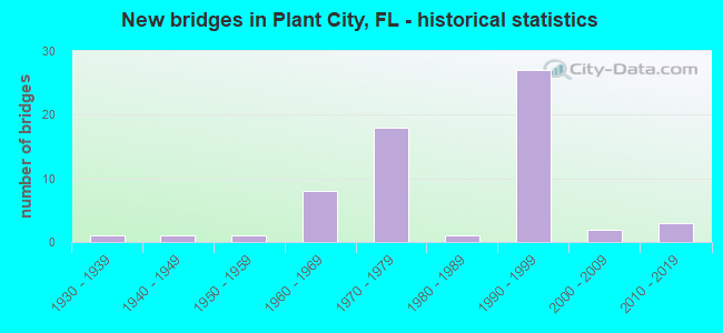
- New bridges - historical statistics
- 11930-1939
- 11940-1949
- 11950-1959
- 81960-1969
- 181970-1979
- 11980-1989
- 271990-1999
- 22000-2009
- 32010-2019

- Reconstructed bridges - Historical Statistics
- 11930-1939
- 01940-1949
- 11950-1959
- 01960-1969
- 01970-1979
- 01980-1989
- 11990-1999
- 22000-2009


- Bridge Condition - Deck
- 20.0%Very good
- 66.7%Good
- 13.3%Satisfactory

- Bridge Condition - Superstructure
- 20.0%Very good
- 70.0%Good
- 10.0%Satisfactory

- Bridge Condition - Substructure
- 16.7%Very good
- 80.0%Good
- 3.3%Fair

- Bridge Condition - Channel
- 5.6%Very good
- 47.2%Good
- 41.7%Satisfactory
- 5.6%Fair

- Bridge Condition - Culverts
- 18.8%Very good
- 68.8%Good
- 12.5%Satisfactory
Find on map >> Show street view
Structure Number: 100032, Location: 0.2MI SOUTH OF US-92 (Lat: 28.015986, Lng: -82.174811), Route carried "on" structure: County highway 574B, Year Built: 1965, Status: Open, Structure Length: 0.70m (2.30ft), Average Daily Traffic: 7,900 (year 2021), Truck Traffic: 8%, Average Future Daily Traffic: 10,863 (year 2042), Design Load: H 15, Features Intersected: HAGGARD CREEK, Facility Carried by Structure: TURKEY CK.RD/574-B
Minimum Vertical Clearance: 30+ m (98+ ft), Kilometerpoint: 1.147, Lanes on structure: 2, Owner: County Highway Agency, Approaching Roadway Width: 7.7m (25.3ft), Skew: 1 degrees, Material/Design: Concrete, Design/Construction: Culvert, Number Of Spans In Main Unit: 3, Length of Maximum Span: 2.2m (7.2ft)
Condition: Channel: Good, Culverts: Satisfactory, Operating Rating: 51.8 metric tons, Method Used To Determine Operating Rating: Load Factor (LF), Inventory Rating: 31.0 metric tons, Method Used To Determine Inventory Rating: Load Factor (LF), Structural Evaluation: Equal to present minimum criteria, Waterway Adequacy: Superior to present desirable criteria, Approach Roadway Alignment: Better than present minimum criteria, Designated Inspection Frequency: Every 24 months, Inspection Date: November 2021
Find on map >> Show street view
Structure Number: 100035, Location: 1.0 MILE EAST OF SR-39 (Lat: 28.078111, Lng: -82.121903), Route carried "on" structure: County highway 582, Year Built: 1973, Status: Open, Structure Length: 1.30m (4.27ft), Average Daily Traffic: 3,200 (year 2021), Truck Traffic: 2%, Average Future Daily Traffic: 4,000 (year 2041), Design Load: HS 20, Features Intersected: ITCHEPACKESASSA CREEK, Facility Carried by Structure: KNIGHTS GRIFFIN RD
Minimum Vertical Clearance: 30.45m (99.90ft), Kilometerpoint: 13.895, Lanes on structure: 2, Owner: County Highway Agency, Approaching Roadway Width: 7.3m (24.0ft), Material/Design: Concrete, Design/Construction: Culvert, Number Of Spans In Main Unit: 4, Length of Maximum Span: 3.1m (10.2ft)
Condition: Channel: Good, Culverts: Good, Operating Rating: 52.1 metric tons, Method Used To Determine Operating Rating: Load Factor (LF), Inventory Rating: 31.2 metric tons, Method Used To Determine Inventory Rating: Load Factor (LF), Structural Evaluation: Better than present minimum criteria, Waterway Adequacy: Equal to present minimum criteria, Approach Roadway Alignment: Equal to present desirable criteria, Designated Inspection Frequency: Every 24 months, Inspection Date: December 2021
Find on map >> Show street view
Structure Number: 100059, Location: 2.1 MILES WEST OF SR-39 (Lat: 27.937581, Lng: -82.156522), Route carried "on" structure: State highway 60, Year Built: 1946, Year Reconstructed: 1962, Status: Open, Structure Length: 0.97m (3.18ft), Average Daily Traffic: 21,500 (year 2021), Truck Traffic: 13%, Average Future Daily Traffic: 37,302 (year 2041), Design Load: HS 20, Features Intersected: LITTLE ALAFIA RIVER
Minimum Vertical Clearance: 30+ m (98+ ft), Kilometerpoint: 27.925, Lanes on structure: 4, Base Highway Network: Yes, Owner: State Highway Agency, Approaching Roadway Width: 21.8m (71.5ft), Skew: 30 degrees, Material/Design: Concrete, Design/Construction: Culvert, Number Of Spans In Main Unit: 3, Length of Maximum Span: 3.0m (9.8ft)
Condition: Channel: Fair, Culverts: Good, Operating Rating: 41.5 metric tons, Method Used To Determine Operating Rating: Load Factor (LF), Inventory Rating: 24.5 metric tons, Method Used To Determine Inventory Rating: Load Factor (LF), Structural Evaluation: Equal to present minimum criteria, Waterway Adequacy: Equal to present desirable criteria, Approach Roadway Alignment: Equal to present desirable criteria, Designated Inspection Frequency: Every 24 months, Underwater Inspection Frequency: Every 24 months, Inspection Date: June 2021, Underwater Inspection Date: May 2021
Find on map >> Show street view
Structure Number: 100093, Location: 0.35MI EAST OF SR-39 (Lat: 28.018289, Lng: -82.119650), Route carried "on" structure: US 92, Year Built: 1970, Status: Open, Structure Length: 0.70m (2.30ft), Average Daily Traffic: 8,000 (year 2020), Truck Traffic: 8%, Average Future Daily Traffic: 13,880 (year 2042), Design Load: HS 20, Features Intersected: EASTSIDE CANAL
Minimum Vertical Clearance: 30.45m (99.90ft), Kilometerpoint: 0.628, Lanes on structure: 2, Base Highway Network: Yes, Owner: State Highway Agency, Approaching Roadway Width: 7.4m (24.3ft), Skew: 3 degrees, Material/Design: Concrete, Design/Construction: Culvert, Number Of Spans In Main Unit: 2, Length of Maximum Span: 3.4m (11.2ft)
Condition: Channel: Good, Culverts: Good, Operating Rating: 67.9 metric tons, Method Used To Determine Operating Rating: Load Factor (LF), Inventory Rating: 40.7 metric tons, Method Used To Determine Inventory Rating: Load Factor (LF), Structural Evaluation: Better than present minimum criteria, Waterway Adequacy: Equal to present desirable criteria, Approach Roadway Alignment: Equal to present desirable criteria, Designated Inspection Frequency: Every 24 months, Inspection Date: June 2020
Find on map >> Show street view
Structure Number: 100098, Location: 0.2MI EAST OF FORBES RD. (Lat: 28.020772, Lng: -82.183575), Route carried "on" structure: US 92, Year Built: 1930, Year Reconstructed: 1943, Status: Open, Structure Length: 0.93m (3.05ft), Average Daily Traffic: 13,800 (year 2021), Truck Traffic: 13%, Average Future Daily Traffic: 23,943 (year 2041), Design Load: H 15, Features Intersected: SPARTMAN BRANCH
Minimum Vertical Clearance: 30+ m (98+ ft), Kilometerpoint: 26.747, Lanes on structure: 2, Base Highway Network: Yes, Owner: State Highway Agency, Approaching Roadway Width: 9.6m (31.5ft), Material/Design: Concrete, Design/Construction: Slab, Number Of Spans In Main Unit: 1, Length of Maximum Span: 9.3m (30.5ft), Curb-To-Curb Width: 9.9m (32.5ft), Out-to-Out Width: 10.2m (33.5ft)
Condition: Deck: Good, Superstructure: Good, Substructure: Good, Channel: Good, Operating Rating: 39.6 metric tons, Method Used To Determine Operating Rating: Load and Resistance Factor (LRFR), Inventory Rating: 30.6 metric tons, Method Used To Determine Inventory Rating: Load and Resistance Factor (LRFR), Structural Evaluation: Better than present minimum criteria, Deck Geometry: Meets minimum limits, Waterway Adequacy: Equal to present desirable criteria, Approach Roadway Alignment: Equal to present desirable criteria, Designated Inspection Frequency: Every 24 months, Inspection Date: June 2021, Deck Structure Type: Concrete Cast-file-Place, Wearing Surface/Protective System: Wearing Surface: Bituminous
Find on map >> Show street view
Structure Number: 100111, Location: 0.2MI SOUTH OF I-4 (Lat: 28.025833, Lng: -82.187022), Route carried "on" structure: Other road , Year Built: 1959, Year Reconstructed: 1999, Status: Open, Structure Length: 0.87m (2.85ft), Average Daily Traffic: 6,200 (year 2020), Truck Traffic: 13%, Average Future Daily Traffic: 10,757 (year 2042), Design Load: H 15, Features Intersected: SPARTMAN BRANCH, Facility Carried by Structure: BRANCH FORBES RD
Minimum Vertical Clearance: 30.45m (99.90ft), Kilometerpoint: 0.531, Lanes on structure: 2, Owner: State Highway Agency, Approaching Roadway Width: 10.0m (32.8ft), Skew: 30 degrees, Material/Design: Concrete, Design/Construction: Culvert, Number Of Spans In Main Unit: 3, Length of Maximum Span: 2.9m (9.5ft)
Condition: Channel: Satisfactory, Culverts: Good, Operating Rating: 45.4 metric tons, Method Used To Determine Operating Rating: Load Factor (LF), Inventory Rating: 27.2 metric tons, Method Used To Determine Inventory Rating: Load Factor (LF), Structural Evaluation: Equal to present minimum criteria, Waterway Adequacy: Equal to present desirable criteria, Approach Roadway Alignment: Equal to present desirable criteria, Designated Inspection Frequency: Every 24 months, Inspection Date: October 2020
Find on map >> Show street view
Structure Number: 100289, Location: 3.1MI EAST OF SR-39 (Lat: 28.080375, Lng: -82.086722), Route carried "on" structure: County highway 582, Year Built: 1973, Status: Open, Structure Length: 0.63m (2.07ft), Average Daily Traffic: 6,900 (year 2020), Truck Traffic: 6%, Average Future Daily Traffic: 11,937 (year 2040), Design Load: HS 20, Features Intersected: SQUEEZE CREEK, Facility Carried by Structure: KNIGHTS GRIFFIN RD
Minimum Vertical Clearance: 30+ m (98+ ft), Kilometerpoint: 17.408, Lanes on structure: 2, Owner: County Highway Agency, Approaching Roadway Width: 7.3m (24.0ft), Material/Design: Concrete, Design/Construction: Culvert, Number Of Spans In Main Unit: 2, Length of Maximum Span: 3.0m (9.8ft)
Condition: Channel: Satisfactory, Culverts: Satisfactory, Operating Rating: 41.0 metric tons, Method Used To Determine Operating Rating: Load Factor (LF), Inventory Rating: 24.6 metric tons, Method Used To Determine Inventory Rating: Load Factor (LF), Structural Evaluation: Equal to present minimum criteria, Waterway Adequacy: Better than present minimum criteria, Approach Roadway Alignment: Equal to present desirable criteria, Designated Inspection Frequency: Every 24 months, Inspection Date: November 2021
Find on map >> Show street view
Structure Number: 100343, Location: 1.5MI EAST OF SR-39 (Lat: 28.047589, Lng: -82.105039), Route carried "on" structure: County highway 580, Year Built: 1976, Status: Open, Structure Length: 0.70m (2.30ft), Average Daily Traffic: 11,000 (year 2020), Truck Traffic: 8%, Average Future Daily Traffic: 19,085 (year 2042), Design Load: HS 20, Features Intersected: PLANT CITY EAST BRANCH, Facility Carried by Structure: SAM ALLEN ROAD
Minimum Vertical Clearance: 30+ m (98+ ft), Kilometerpoint: 2.401, Lanes on structure: 2, Owner: County Highway Agency, Approaching Roadway Width: 10.2m (33.5ft), Skew: 4 degrees, Material/Design: Concrete, Design/Construction: Culvert, Number Of Spans In Main Unit: 2, Length of Maximum Span: 3.4m (11.2ft)
Condition: Channel: Satisfactory, Culverts: Good, Operating Rating: 36.9 metric tons, Method Used To Determine Operating Rating: Load Factor (LF), Inventory Rating: 22.1 metric tons, Method Used To Determine Inventory Rating: Load Factor (LF), Structural Evaluation: Somewhat better than minimum adequacy, Waterway Adequacy: Better than present minimum criteria, Approach Roadway Alignment: Equal to present desirable criteria, Designated Inspection Frequency: Every 24 months, Inspection Date: November 2021
Find on map >> Show street view
Structure Number: 100345, Location: 0.3MI NORTH OF I-4 (Lat: 28.043472, Lng: -82.104281), Route carried "on" structure: County highway , Year Built: 1976, Year Reconstructed: 2011, Status: Open, Structure Length: 0.71m (2.33ft), Average Daily Traffic: 5,900 (year 2020), Truck Traffic: 13%, Average Future Daily Traffic: 10,237 (year 2042), Design Load: HL 93, Features Intersected: PLANT CITY EAST BRANCH, Facility Carried by Structure: PARK ROAD
Minimum Vertical Clearance: 30+ m (98+ ft), Kilometerpoint: 2.401, Lanes on structure: 4, Owner: County Highway Agency, Approaching Roadway Width: 17.3m (56.8ft), Skew: 23 degrees, Material/Design: Concrete, Design/Construction: Culvert, Number Of Spans In Main Unit: 2, Length of Maximum Span: 3.4m (11.2ft)
Condition: Channel: Satisfactory, Culverts: Good, Operating Rating: 45.4 metric tons, Method Used To Determine Operating Rating: Load and Resistance Factor (LRFR), Inventory Rating: 34.9 metric tons, Method Used To Determine Inventory Rating: Load and Resistance Factor (LRFR), Structural Evaluation: Better than present minimum criteria, Waterway Adequacy: Equal to present minimum criteria, Approach Roadway Alignment: Equal to present desirable criteria, Designated Inspection Frequency: Every 24 months, Inspection Date: November 2021
Find on map >> Show street view
Structure Number: 100599, Location: 3.5MI EAST OF MCINTOSH RD (Lat: 28.027222, Lng: -82.186944), Route carried "on" structure: Interstate 4, Year Built: 1999, Status: Open, Structure Length: 4.94m (16.21ft), Average Daily Traffic: 59,750 (year 2020), Truck Traffic: 13%, Average Future Daily Traffic: 103,666 (year 2042), Design Load: HS 20+Mod, Features Intersected: BRANCH FORBES ROAD
Minimum Vertical Clearance: 30+ m (98+ ft), Kilometerpoint: 39.778, Lanes on structure: 3, Lanes under structure: 3, Base Highway Network: Yes, Owner: State Highway Agency, Approaching Roadway Width: 17.1m (56.1ft), Material/Design: Prestressed concrete, Design/Construction: Stringer/Multi-beam, Number Of Spans In Main Unit: 2, Length of Maximum Span: 24.7m (81.0ft), Curb-To-Curb Width: 17.1m (56.1ft), Out-to-Out Width: 18.0m (59.1ft)
Condition: Deck: Good, Superstructure: Very good, Substructure: Very good, Inventory Rating: 67.0 metric tons, Method Used To Determine Inventory Rating: Load Factor (LF), Structural Evaluation: Equal to present desirable criteria, Deck Geometry: Equal to present minimum criteria, Underclear: Superior to present desirable criteria, Approach Roadway Alignment: Equal to present desirable criteria, Designated Inspection Frequency: Every 24 months, Inspection Date: October 2020, Deck Structure Type: Concrete Cast-file-Place
Find on map >> Show street view
Structure Number: 1006, Location: 3.5MI E OF MCINTOSH RD (Lat: 28.026861, Lng: -82.187000), Route carried "on" structure: Interstate 4, Year Built: 1999, Status: Open, Structure Length: 4.94m (16.21ft), Average Daily Traffic: 59,750 (year 2020), Truck Traffic: 13%, Average Future Daily Traffic: 103,666 (year 2042), Design Load: HS 20+Mod, Features Intersected: BRANCH FORBES ROAD
Minimum Vertical Clearance: 30+ m (98+ ft), Kilometerpoint: 39.778, Lanes on structure: 3, Lanes under structure: 2, Base Highway Network: Yes, Owner: State Highway Agency, Approaching Roadway Width: 17.1m (56.1ft), Material/Design: Prestressed concrete, Design/Construction: Stringer/Multi-beam, Number Of Spans In Main Unit: 2, Length of Maximum Span: 24.7m (81.0ft), Curb-To-Curb Width: 17.1m (56.1ft), Out-to-Out Width: 18.0m (59.1ft)
Condition: Deck: Good, Superstructure: Very good, Substructure: Very good, Inventory Rating: 67.0 metric tons, Method Used To Determine Inventory Rating: Load Factor (LF), Structural Evaluation: Equal to present desirable criteria, Deck Geometry: Equal to present minimum criteria, Underclear: Superior to present desirable criteria, Approach Roadway Alignment: Equal to present desirable criteria, Designated Inspection Frequency: Every 24 months, Inspection Date: October 2020, Deck Structure Type: Concrete Cast-file-Place
Find on map >> Show street view
Structure Number: 100602, Location: 1.5MI WEST OF SR-39 (Lat: 28.027067, Lng: -82.152928), Route carried "on" structure: Interstate 4, Year Built: 1999, Status: Open, Structure Length: 7.32m (24.02ft), Average Daily Traffic: 59,250 (year 2020), Truck Traffic: 12%, Average Future Daily Traffic: 102,799 (year 2042), Design Load: HS 20+Mod, Features Intersected: SR-566
Minimum Vertical Clearance: 30+ m (98+ ft), Kilometerpoint: 43.122, Lanes on structure: 3, Lanes under structure: 2, Base Highway Network: Yes, Owner: State Highway Agency, Approaching Roadway Width: 17.1m (56.1ft), Skew: 5 degrees, Material/Design: Prestressed concrete, Design/Construction: Stringer/Multi-beam, Number Of Spans In Main Unit: 2, Length of Maximum Span: 39.6m (129.9ft), Curb-To-Curb Width: 17.1m (56.1ft), Out-to-Out Width: 18.0m (59.1ft)
Condition: Deck: Good, Superstructure: Very good, Substructure: Very good, Operating Rating: 69.1 metric tons, Method Used To Determine Operating Rating: Load Factor (LF), Inventory Rating: 41.5 metric tons, Method Used To Determine Inventory Rating: Load Factor (LF), Structural Evaluation: Equal to present desirable criteria, Deck Geometry: Equal to present minimum criteria, Underclear: Superior to present desirable criteria, Approach Roadway Alignment: Equal to present desirable criteria, Designated Inspection Frequency: Every 24 months, Inspection Date: October 2020, Deck Structure Type: Concrete Cast-file-Place
Find on map >> Show street view
Structure Number: 100605, Location: 0.5MI E OF N ALEXANDER ST (Lat: 28.035472, Lng: -82.125694), Route carried "on" structure: Interstate 4, Year Built: 1999, Status: Open, Structure Length: 12.05m (39.53ft), Average Daily Traffic: 56,750 (year 2020), Truck Traffic: 12%, Average Future Daily Traffic: 98,461 (year 2042), Design Load: HS 20+Mod, Features Intersected: SR-39 & RR & FRONTAGE RD
Minimum Vertical Clearance: 30+ m (98+ ft), Kilometerpoint: 45.950, Lanes on structure: 4, Lanes under structure: 6, Base Highway Network: Yes, Owner: State Highway Agency, Approaching Roadway Width: 25.4m (83.3ft), Skew: 30 degrees, Material/Design: Steel, Design/Construction: Stringer/Multi-beam, Number Of Spans In Main Unit: 1, Number Of Approach Spans: 2, Length of Maximum Span: 66.8m (219.2ft), Curb-To-Curb Width: 25.4m (83.3ft), Out-to-Out Width: 26.8m (87.9ft)
Condition: Deck: Good, Superstructure: Good, Substructure: Good, Operating Rating: 56.0 metric tons, Method Used To Determine Operating Rating: Load Factor (LF), Inventory Rating: 33.6 metric tons, Method Used To Determine Inventory Rating: Load Factor (LF), Structural Evaluation: Better than present minimum criteria, Deck Geometry: Superior to present desirable criteria, Underclear: Equal to present minimum criteria, Approach Roadway Alignment: Equal to present desirable criteria, Designated Inspection Frequency: Every 24 months, Inspection Date: October 2020, Deck Structure Type: Concrete Cast-file-Place
Find on map >> Show street view
Structure Number: 100606, Location: 0.5MI E OF N ALEXANDER ST (Lat: 28.035019, Lng: -82.125650), Route carried "on" structure: Interstate 4, Year Built: 1999, Status: Open, Structure Length: 12.05m (39.53ft), Average Daily Traffic: 56,750 (year 2020), Truck Traffic: 12%, Average Future Daily Traffic: 98,461 (year 2042), Design Load: HS 20+Mod, Features Intersected: SR-39 & RR & FRONTAGE RD
Minimum Vertical Clearance: 30+ m (98+ ft), Kilometerpoint: 45.947, Lanes on structure: 4, Lanes under structure: 6, Base Highway Network: Yes, Owner: State Highway Agency, Approaching Roadway Width: 25.4m (83.3ft), Skew: 30 degrees, Material/Design: Steel, Design/Construction: Stringer/Multi-beam, Number Of Spans In Main Unit: 1, Number Of Approach Spans: 2, Length of Maximum Span: 66.8m (219.2ft), Curb-To-Curb Width: 25.4m (83.3ft), Out-to-Out Width: 26.9m (88.3ft)
Condition: Deck: Good, Superstructure: Good, Substructure: Good, Operating Rating: 56.0 metric tons, Method Used To Determine Operating Rating: Load Factor (LF), Inventory Rating: 33.6 metric tons, Method Used To Determine Inventory Rating: Load Factor (LF), Structural Evaluation: Better than present minimum criteria, Deck Geometry: Superior to present desirable criteria, Underclear: Better than present minimum criteria, Approach Roadway Alignment: Equal to present desirable criteria, Designated Inspection Frequency: Every 24 months, Inspection Date: October 2020, Deck Structure Type: Concrete Cast-file-Place
Find on map >> Show street view
Structure Number: 100607, Location: 1.2 MI EAST OF SR-39 (Lat: 28.036875, Lng: -82.104464), Route carried "on" structure: Interstate 4, Year Built: 1999, Status: Open, Structure Length: 4.63m (15.19ft), Average Daily Traffic: 54,000 (year 2020), Truck Traffic: 12%, Average Future Daily Traffic: 93,690 (year 2042), Design Load: HS 20+Mod, Features Intersected: PARK ROAD (SR-553)
Minimum Vertical Clearance: 30+ m (98+ ft), Kilometerpoint: 48.039, Lanes on structure: 3, Lanes under structure: 6, Base Highway Network: Yes, Owner: State Highway Agency, Approaching Roadway Width: 17.1m (56.1ft), Material/Design: Prestressed concrete, Design/Construction: Stringer/Multi-beam, Number Of Spans In Main Unit: 2, Length of Maximum Span: 23.2m (76.1ft), Curb-To-Curb Width: 17.1m (56.1ft), Out-to-Out Width: 18.1m (59.4ft)
Condition: Deck: Good, Superstructure: Very good, Substructure: Good, Inventory Rating: 64.4 metric tons, Method Used To Determine Inventory Rating: Load Factor (LF), Structural Evaluation: Better than present minimum criteria, Deck Geometry: Equal to present minimum criteria, Underclear: Better than present minimum criteria, Approach Roadway Alignment: Equal to present desirable criteria, Designated Inspection Frequency: Every 24 months, Inspection Date: October 2020, Deck Structure Type: Concrete Cast-file-Place
Find on map >> Show street view
Structure Number: 100608, Location: 1.2MI EAST OF SR-39 (Lat: 28.036528, Lng: -82.104494), Route carried "on" structure: Interstate 4, Year Built: 1999, Status: Open, Structure Length: 4.63m (15.19ft), Average Daily Traffic: 58,500 (year 2020), Truck Traffic: 15%, Average Future Daily Traffic: 101,498 (year 2042), Design Load: HS 20+Mod, Features Intersected: PARK ROAD (SR-553)
Minimum Vertical Clearance: 30+ m (98+ ft), Kilometerpoint: 48.086, Lanes on structure: 3, Lanes under structure: 6, Base Highway Network: Yes, Owner: State Highway Agency, Approaching Roadway Width: 17.1m (56.1ft), Material/Design: Prestressed concrete, Design/Construction: Stringer/Multi-beam, Number Of Spans In Main Unit: 2, Length of Maximum Span: 23.2m (76.1ft), Curb-To-Curb Width: 17.1m (56.1ft), Out-to-Out Width: 18.1m (59.4ft)
Condition: Deck: Good, Superstructure: Good, Substructure: Very good, Inventory Rating: 64.4 metric tons, Method Used To Determine Inventory Rating: Load Factor (LF), Structural Evaluation: Better than present minimum criteria, Deck Geometry: Equal to present minimum criteria, Underclear: Better than present minimum criteria, Approach Roadway Alignment: Equal to present desirable criteria, Designated Inspection Frequency: Every 24 months, Inspection Date: October 2020, Deck Structure Type: Concrete Cast-file-Place
Find on map >> Show street view
Structure Number: 100609, Location: 3.7 MI EAST OF SR-39 (Lat: 28.037086, Lng: -82.072394), Route carried "on" structure: Interstate 4, Year Built: 1999, Status: Open, Structure Length: 2.30m (7.55ft), Average Daily Traffic: 58,500 (year 2020), Truck Traffic: 15%, Average Future Daily Traffic: 101,498 (year 2042), Design Load: HS 20+Mod, Features Intersected: CHARLIE TAYLOR RD
Minimum Vertical Clearance: 30+ m (98+ ft), Kilometerpoint: 51.253, Lanes on structure: 3, Lanes under structure: 2, Base Highway Network: Yes, Owner: State Highway Agency, Approaching Roadway Width: 16.8m (55.1ft), Material/Design: Prestressed concrete, Design/Construction: Stringer/Multi-beam, Number Of Spans In Main Unit: 1, Length of Maximum Span: 23.0m (75.5ft), Curb-To-Curb Width: 16.8m (55.1ft), Out-to-Out Width: 17.8m (58.4ft)
Condition: Deck: Good, Superstructure: Good, Substructure: Good, Inventory Rating: 64.2 metric tons, Method Used To Determine Inventory Rating: Load Factor (LF), Structural Evaluation: Better than present minimum criteria, Deck Geometry: Equal to present minimum criteria, Underclear: Superior to present desirable criteria, Approach Roadway Alignment: Equal to present desirable criteria, Designated Inspection Frequency: Every 24 months, Inspection Date: October 2020, Deck Structure Type: Concrete Cast-file-Place
Find on map >> Show street view
Structure Number: 10061, Location: 3.7 MI EAST OF SR-39 (Lat: 28.036739, Lng: -82.072386), Route carried "on" structure: Interstate 4, Year Built: 1999, Status: Open, Structure Length: 2.30m (7.55ft), Average Daily Traffic: 58,500 (year 2020), Truck Traffic: 15%, Average Future Daily Traffic: 101,498 (year 2042), Design Load: HS 20+Mod, Features Intersected: CHARLIE TAYLOR RD
Minimum Vertical Clearance: 30+ m (98+ ft), Kilometerpoint: 51.253, Lanes on structure: 3, Lanes under structure: 2, Base Highway Network: Yes, Owner: State Highway Agency, Approaching Roadway Width: 16.8m (55.1ft), Material/Design: Prestressed concrete, Design/Construction: Stringer/Multi-beam, Number Of Spans In Main Unit: 1, Length of Maximum Span: 23.0m (75.5ft), Curb-To-Curb Width: 16.8m (55.1ft), Out-to-Out Width: 17.8m (58.4ft)
Condition: Deck: Good, Superstructure: Very good, Substructure: Good, Inventory Rating: 64.2 metric tons, Method Used To Determine Inventory Rating: Load Factor (LF), Structural Evaluation: Better than present minimum criteria, Deck Geometry: Equal to present minimum criteria, Underclear: Superior to present desirable criteria, Approach Roadway Alignment: Equal to present desirable criteria, Designated Inspection Frequency: Every 24 months, Inspection Date: October 2020, Deck Structure Type: Concrete Cast-file-Place
Find on map >> Show street view
Structure Number: 100616, Location: 5.5MI EAST OF CR-579 (Lat: 28.027617, Lng: -82.215944), Route carried "on" structure: County highway , Year Built: 1999, Status: Open, Structure Length: 9.80m (32.15ft), Average Daily Traffic: 2,500 (year 2021), Truck Traffic: 5%, Average Future Daily Traffic: 4,000 (year 2041), Design Load: HS 20+Mod, Features Intersected: I-4 (SR-400), Facility Carried by Structure: FRITZKE ROAD
Minimum Vertical Clearance: 30+ m (98+ ft), Kilometerpoint: 0.546, Lanes on structure: 2, Lanes under structure: 6, Owner: State Highway Agency, Approaching Roadway Width: 14.2m (46.6ft), Material/Design: Steel continuous, Design/Construction: Stringer/Multi-beam, Number Of Spans In Main Unit: 2, Length of Maximum Span: 49.0m (160.8ft), Curb-To-Curb Width: 13.5m (44.3ft), Out-to-Out Width: 14.5m (47.6ft)
Condition: Deck: Good, Superstructure: Good, Substructure: Good, Operating Rating: 56.4 metric tons, Method Used To Determine Operating Rating: Load Factor (LF), Inventory Rating: 33.8 metric tons, Method Used To Determine Inventory Rating: Load Factor (LF), Structural Evaluation: Better than present minimum criteria, Deck Geometry: Superior to present desirable criteria, Underclear: Superior to present desirable criteria, Approach Roadway Alignment: Equal to present desirable criteria, Designated Inspection Frequency: Every 24 months, Inspection Date: March 2021, Deck Structure Type: Concrete Cast-file-Place
Find on map >> Show street view
Structure Number: 100621, Location: 150YDS W OF BR FORBES RD (Lat: 28.026778, Lng: -82.191139), Route carried "on" structure: Interstate 4, Year Built: 2001, Status: Open, Structure Length: 0.90m (2.95ft), Average Daily Traffic: 132,000 (year 2020), Truck Traffic: 11%, Average Future Daily Traffic: 229,020 (year 2042), Design Load: HS 20, Features Intersected: SPORTSMAN BRANCH
Minimum Vertical Clearance: 30+ m (98+ ft), Kilometerpoint: 39.397, Lanes on structure: 8, Base Highway Network: Yes, Owner: State Highway Agency, Approaching Roadway Width: 47.8m (156.8ft), Skew: 10 degrees, Material/Design: Concrete, Design/Construction: Culvert, Number Of Spans In Main Unit: 3, Length of Maximum Span: 2.4m (7.9ft)
Condition: Channel: Satisfactory, Culverts: Good, Operating Rating: 52.6 metric tons, Method Used To Determine Operating Rating: Load Factor (LF), Inventory Rating: 31.8 metric tons, Method Used To Determine Inventory Rating: Load Factor (LF), Structural Evaluation: Better than present minimum criteria, Waterway Adequacy: Equal to present desirable criteria, Approach Roadway Alignment: Equal to present desirable criteria, Designated Inspection Frequency: Every 24 months, Inspection Date: October 2020
Find on map >> Show street view
Structure Number: 104359, Location: 0.2MI N/O I-4 (Lat: 28.036056, Lng: -82.134250), Route carried "on" structure: State highway 39, Year Built: 2013, Status: Open, Structure Length: 1.39m (4.56ft), Average Daily Traffic: 1,700 (year 2021), Truck Traffic: 5%, Average Future Daily Traffic: 2,125 (year 2041), Design Load: HL 93, Features Intersected: Westside Canal Tributary
Minimum Vertical Clearance: 30+ m (98+ ft), Kilometerpoint: 6.598, Lanes on structure: 4, Base Highway Network: Yes, Owner: State Highway Agency, Approaching Roadway Width: 21.9m (71.9ft), Skew: 20 degrees, Material/Design: Concrete, Design/Construction: Culvert, Number Of Spans In Main Unit: 4, Length of Maximum Span: 3.1m (10.2ft)
Condition: Channel: Satisfactory, Culverts: Very good, Operating Rating: 86.2 metric tons, Method Used To Determine Operating Rating: Load and Resistance Factor (LRFR), Inventory Rating: 66.6 metric tons, Method Used To Determine Inventory Rating: Load and Resistance Factor (LRFR), Structural Evaluation: Equal to present desirable criteria, Waterway Adequacy: Superior to present desirable criteria, Approach Roadway Alignment: Equal to present desirable criteria, Designated Inspection Frequency: Every 24 months, Inspection Date: October 2021
Find on map >> Show street view
Structure Number: 104401, Location: 0.6MI E OF JAP TUCKER RD (Lat: 27.981814, Lng: -82.091275), Route carried "on" structure: County highway , Year Built: 1974, Status: Open, Structure Length: 0.92m (3.02ft), Average Daily Traffic: 5,240 (year 2021), Truck Traffic: 3%, Average Future Daily Traffic: 6,288 (year 2041), Design Load: H 15, Features Intersected: HOWELL BRANCH, Facility Carried by Structure: JIM JOHNSON RD
Minimum Vertical Clearance: 30+ m (98+ ft), Kilometerpoint: 0.000, Lanes on structure: 2, Owner: County Highway Agency, Approaching Roadway Width: 6.3m (20.7ft), Material/Design: Prestressed concrete, Design/Construction: Channel Beam, Number Of Spans In Main Unit: 1, Length of Maximum Span: 9.2m (30.2ft), Curb or Sidewalk Widths: Left: 0.0m, Right: 0.6m (2.0ft), Curb-To-Curb Width: 8.0m (26.2ft), Out-to-Out Width: 9.8m (32.2ft)
Condition: Deck: Good, Superstructure: Satisfactory, Substructure: Good, Channel: Good, Operating Rating: 59.7 metric tons, Method Used To Determine Operating Rating: Load Factor (LF), Inventory Rating: 35.8 metric tons, Method Used To Determine Inventory Rating: Load Factor (LF), Structural Evaluation: Equal to present minimum criteria, Deck Geometry: High priority of replacement, Waterway Adequacy: Better than present minimum criteria, Approach Roadway Alignment: Equal to present desirable criteria, Designated Inspection Frequency: Every 24 months, Inspection Date: December 2021, Deck Structure Type: Concrete Cast-file-Place, Wearing Surface/Protective System: Wearing Surface: Bituminous
Find on map >> Show street view
Structure Number: 104402, Location: 0.4 MI. N OF HOLLOWAY RD (Lat: 27.959286, Lng: -82.129428), Route carried "on" structure: County highway , Year Built: 1974, Status: Open, Structure Length: 0.93m (3.05ft), Average Daily Traffic: 330 (year 2021), Truck Traffic: 1%, Average Future Daily Traffic: 573 (year 2042), Design Load: H 15, Features Intersected: GRASSY CREEK BRANCH, Facility Carried by Structure: PIPPIN ROAD
Minimum Vertical Clearance: 30+ m (98+ ft), Kilometerpoint: 0.000, Lanes on structure: 2, Base Highway Network: Yes, Owner: County Highway Agency, Approaching Roadway Width: 6.3m (20.7ft), Material/Design: Prestressed concrete, Design/Construction: Channel Beam, Number Of Spans In Main Unit: 1, Length of Maximum Span: 9.3m (30.5ft), Curb or Sidewalk Widths: Left: 0.5m (1.6ft), Right: 0.5m (1.6ft), Curb-To-Curb Width: 8.0m (26.2ft), Out-to-Out Width: 9.8m (32.2ft)
Condition: Deck: Satisfactory, Superstructure: Satisfactory, Substructure: Good, Channel: Good, Operating Rating: 46.6 metric tons, Method Used To Determine Operating Rating: Load Factor (LF), Inventory Rating: 27.9 metric tons, Method Used To Determine Inventory Rating: Load Factor (LF), Structural Evaluation: Equal to present minimum criteria, Deck Geometry: Somewhat better than minimum adequacy, Waterway Adequacy: Better than present minimum criteria, Approach Roadway Alignment: Equal to present desirable criteria, Designated Inspection Frequency: Every 24 months, Inspection Date: November 2021, Deck Structure Type: Concrete Cast-file-Place
Find on map >> Show street view
Structure Number: 104403, Location: 0.3 MI. NORTH OF I-4 (Lat: 28.031444, Lng: -82.186947), Route carried "on" structure: County highway , Year Built: 1974, Status: Open, Structure Length: 0.91m (2.99ft), Average Daily Traffic: 6,200 (year 2020), Truck Traffic: 12%, Average Future Daily Traffic: 10,757 (year 2042), Design Load: HS 15, Features Intersected: PEMBERTON CREEK, Facility Carried by Structure: BRANCH FORBES RD.
Minimum Vertical Clearance: 30+ m (98+ ft), Kilometerpoint: 1.128, Lanes on structure: 2, Owner: County Highway Agency, Approaching Roadway Width: 6.9m (22.6ft), Material/Design: Prestressed concrete, Design/Construction: Channel Beam, Number Of Spans In Main Unit: 1, Length of Maximum Span: 9.1m (29.9ft), Curb or Sidewalk Widths: Left: 0.6m (2.0ft), Right: 0.6m (2.0ft), Curb-To-Curb Width: 8.1m (26.6ft), Out-to-Out Width: 9.8m (32.2ft)
Condition: Deck: Good, Superstructure: Good, Substructure: Good, Channel: Good, Operating Rating: 49.7 metric tons, Method Used To Determine Operating Rating: Load Factor (LF), Inventory Rating: 29.8 metric tons, Method Used To Determine Inventory Rating: Load Factor (LF), Structural Evaluation: Better than present minimum criteria, Deck Geometry: High priority of replacement, Waterway Adequacy: Equal to present desirable criteria, Approach Roadway Alignment: Equal to present desirable criteria, Designated Inspection Frequency: Every 24 months, Inspection Date: November 2021, Deck Structure Type: Concrete Cast-file-Place
Find on map >> Show street view
Structure Number: 104404, Location: 0.6M S OF THONOTOSASSA RD (Lat: 28.033222, Lng: -82.178914), Route carried "on" structure: County highway , Year Built: 1974, Status: Open, Structure Length: 0.93m (3.05ft), Average Daily Traffic: 550 (year 2020), Truck Traffic: 2%, Average Future Daily Traffic: 954 (year 2042), Design Load: H 15, Features Intersected: MILL CREEK, Facility Carried by Structure: HAWK GRIFFIN ROAD
Minimum Vertical Clearance: 30+ m (98+ ft), Kilometerpoint: 0.000, Lanes on structure: 2, Owner: County Highway Agency, Approaching Roadway Width: 5.8m (19.0ft), Material/Design: Prestressed concrete, Design/Construction: Channel Beam, Number Of Spans In Main Unit: 1, Length of Maximum Span: 9.3m (30.5ft), Curb or Sidewalk Widths: Left: 0.6m (2.0ft), Right: 0.6m (2.0ft), Curb-To-Curb Width: 8.0m (26.2ft), Out-to-Out Width: 9.8m (32.2ft)
Condition: Deck: Very good, Superstructure: Good, Substructure: Good, Channel: Satisfactory, Operating Rating: 64.0 metric tons, Method Used To Determine Operating Rating: Load Factor (LF), Inventory Rating: 38.8 metric tons, Method Used To Determine Inventory Rating: Load Factor (LF), Structural Evaluation: Better than present minimum criteria, Deck Geometry: Somewhat better than minimum adequacy, Waterway Adequacy: Better than present minimum criteria, Approach Roadway Alignment: Equal to present desirable criteria, Designated Inspection Frequency: Every 24 months, Inspection Date: November 2021, Deck Structure Type: Concrete Cast-file-Place, Wearing Surface/Protective System: Wearing Surface: Bituminous
Find on map >> Show street view
Structure Number: 104408, Location: 0.6 MI EAST OF SR-39 (Lat: 28.040444, Lng: -82.116622), Route carried "on" structure: County highway , Year Built: 1966, Status: Open, Structure Length: 0.92m (3.02ft), Average Daily Traffic: 520 (year 2021), Truck Traffic: 2%, Average Future Daily Traffic: 902 (year 2042), Design Load: H 15, Features Intersected: EAST CANAL, Facility Carried by Structure: EAST TERRACE DRIVE
Minimum Vertical Clearance: 30+ m (98+ ft), Kilometerpoint: 0.000, Lanes on structure: 2, Owner: County Highway Agency, Approaching Roadway Width: 5.6m (18.4ft), Material/Design: Prestressed concrete, Design/Construction: Channel Beam, Number Of Spans In Main Unit: 1, Length of Maximum Span: 9.2m (30.2ft), Curb or Sidewalk Widths: Left: 0.2m (0.7ft), Right: 0.2m (0.7ft), Curb-To-Curb Width: 7.6m (24.9ft), Out-to-Out Width: 8.2m (26.9ft)
Condition: Deck: Satisfactory, Superstructure: Good, Substructure: Good, Channel: Satisfactory, Operating Rating: 69.1 metric tons, Method Used To Determine Operating Rating: Load Factor (LF), Inventory Rating: 41.5 metric tons, Method Used To Determine Inventory Rating: Load Factor (LF), Structural Evaluation: Better than present minimum criteria, Deck Geometry: Meets minimum limits, Waterway Adequacy: Equal to present minimum criteria, Approach Roadway Alignment: Equal to present desirable criteria, Designated Inspection Frequency: Every 24 months, Inspection Date: November 2021, Deck Structure Type: Concrete Cast-file-Place
Find on map >> Show street view
Structure Number: 104411, Location: 0.5MI S OF SAM ALLEN RD. (Lat: 28.040778, Lng: -82.154208), Route carried "on" structure: County highway , Year Built: 1966, Status: Open, Structure Length: 0.92m (3.02ft), Average Daily Traffic: 710 (year 2021), Truck Traffic: 5%, Average Future Daily Traffic: 1,232 (year 2042), Design Load: HS 15, Features Intersected: PEMBERTON CREEK, Facility Carried by Structure: WALLACE BRANCH RD.
Minimum Vertical Clearance: 30+ m (98+ ft), Kilometerpoint: 0.000, Lanes on structure: 2, Owner: County Highway Agency, Approaching Roadway Width: 5.9m (19.4ft), Material/Design: Prestressed concrete, Design/Construction: Channel Beam, Number Of Spans In Main Unit: 1, Length of Maximum Span: 9.2m (30.2ft), Curb or Sidewalk Widths: Left: 0.3m (1.0ft), Right: 0.3m (1.0ft), Curb-To-Curb Width: 7.7m (25.3ft), Out-to-Out Width: 8.2m (26.9ft)
Condition: Deck: Satisfactory, Superstructure: Good, Substructure: Good, Channel: Good, Operating Rating: 54.6 metric tons, Method Used To Determine Operating Rating: Load Factor (LF), Inventory Rating: 32.7 metric tons, Method Used To Determine Inventory Rating: Load Factor (LF), Structural Evaluation: Better than present minimum criteria, Deck Geometry: Meets minimum limits, Waterway Adequacy: Better than present minimum criteria, Approach Roadway Alignment: Better than present minimum criteria, Designated Inspection Frequency: Every 24 months, Inspection Date: November 2021, Deck Structure Type: Concrete Cast-file-Place
Find on map >> Show street view
Structure Number: 104412, Location: 0.1MI EAST OF FORBES RD. (Lat: 28.025083, Lng: -82.186017), Route carried "on" structure: County highway , Year Built: 1960, Status: Open, Structure Length: 0.92m (3.02ft), Average Daily Traffic: 270 (year 2021), Truck Traffic: 2%, Average Future Daily Traffic: 468 (year 2042), Design Load: H 15, Features Intersected: SPARKMAN CREEK, Facility Carried by Structure: BEAUCHAMP ROAD
Minimum Vertical Clearance: 30+ m (98+ ft), Kilometerpoint: 0.000, Lanes on structure: 2, Owner: County Highway Agency, Approaching Roadway Width: 6.2m (20.3ft), Material/Design: Prestressed concrete, Design/Construction: Channel Beam, Number Of Spans In Main Unit: 1, Length of Maximum Span: 9.2m (30.2ft), Curb-To-Curb Width: 7.6m (24.9ft), Out-to-Out Width: 8.2m (26.9ft)
Condition: Deck: Satisfactory, Superstructure: Good, Substructure: Good, Channel: Good, Operating Rating: 70.0 metric tons, Method Used To Determine Operating Rating: Load Factor (LF), Inventory Rating: 42.0 metric tons, Method Used To Determine Inventory Rating: Load Factor (LF), Structural Evaluation: Better than present minimum criteria, Deck Geometry: Somewhat better than minimum adequacy, Waterway Adequacy: Better than present minimum criteria, Approach Roadway Alignment: Equal to present minimum criteria, Designated Inspection Frequency: Every 24 months, Inspection Date: November 2021, Deck Structure Type: Concrete Cast-file-Place
Find on map >> Show street view
Structure Number: 104416, Location: 1.7 MI WEST OF SR-39 (Lat: 27.952250, Lng: -82.148108), Route carried "on" structure: County highway , Year Built: 1971, Status: Open, Structure Length: 0.94m (3.08ft), Average Daily Traffic: 1,500 (year 2021), Truck Traffic: 5%, Average Future Daily Traffic: 2,603 (year 2042), Design Load: H 15, Features Intersected: MUD LAKE BRANCH, Facility Carried by Structure: HOLLOWAY ROAD
Minimum Vertical Clearance: 30+ m (98+ ft), Kilometerpoint: 0.000, Lanes on structure: 2, Owner: County Highway Agency, Approaching Roadway Width: 7.0m (23.0ft), Material/Design: Prestressed concrete, Design/Construction: Channel Beam, Number Of Spans In Main Unit: 1, Length of Maximum Span: 9.4m (30.8ft), Curb or Sidewalk Widths: Left: 0.6m (2.0ft), Right: 0.6m (2.0ft), Curb-To-Curb Width: 8.0m (26.2ft), Out-to-Out Width: 9.7m (31.8ft)
Condition: Deck: Good, Superstructure: Good, Substructure: Good, Channel: Very good, Operating Rating: 77.2 metric tons, Method Used To Determine Operating Rating: Load Factor (LF), Inventory Rating: 46.3 metric tons, Method Used To Determine Inventory Rating: Load Factor (LF), Structural Evaluation: Better than present minimum criteria, Deck Geometry: Meets minimum limits, Waterway Adequacy: Meets minimum limits, Approach Roadway Alignment: Equal to present desirable criteria, Designated Inspection Frequency: Every 24 months, Underwater Inspection Frequency: Every 23 months, Inspection Date: November 2021, Underwater Inspection Date: November 2021, Deck Structure Type: Concrete Cast-file-Place, Wearing Surface/Protective System: Wearing Surface: Bituminous
Find on map >> Show street view
Structure Number: 104417, Location: 1.0 MILE WEST OF SR-39 (Lat: 27.952283, Lng: -82.137444), Route carried "on" structure: County highway , Year Built: 1970, Status: Open, Structure Length: 1.62m (5.31ft), Average Daily Traffic: 1,620 (year 2021), Truck Traffic: 5%, Average Future Daily Traffic: 2,025 (year 2041), Design Load: H 15, Features Intersected: TURKEY CREEK NO BRANCH, Facility Carried by Structure: HOLLOWAY ROAD
Minimum Vertical Clearance: 30+ m (98+ ft), Kilometerpoint: 0.000, Lanes on structure: 2, Owner: County Highway Agency, Approaching Roadway Width: 6.3m (20.7ft), Material/Design: Prestressed concrete, Design/Construction: Channel Beam, Number Of Spans In Main Unit: 2, Length of Maximum Span: 8.2m (26.9ft), Curb-To-Curb Width: 7.4m (24.3ft), Out-to-Out Width: 8.0m (26.2ft)
Condition: Deck: Good, Superstructure: Good, Substructure: Good, Channel: Satisfactory, Operating Rating: 55.5 metric tons, Method Used To Determine Operating Rating: Load Factor (LF), Inventory Rating: 33.2 metric tons, Method Used To Determine Inventory Rating: Load Factor (LF), Structural Evaluation: Better than present minimum criteria, Deck Geometry: Meets minimum limits, Waterway Adequacy: Better than present minimum criteria, Approach Roadway Alignment: Equal to present desirable criteria, Designated Inspection Frequency: Every 24 months, Underwater Inspection Frequency: Every 23 months, Inspection Date: November 2021, Underwater Inspection Date: November 2021, Deck Structure Type: Concrete Cast-file-Place, Wearing Surface/Protective System: Wearing Surface: Bituminous
Find on map >> Show street view
Structure Number: 104418, Location: 0.4MI S OF HOLLOWAY ROAD (Lat: 27.946489, Lng: -82.147606), Route carried "on" structure: County highway , Year Built: 1971, Status: Open, Structure Length: 1.84m (6.04ft), Average Daily Traffic: 520 (year 2021), Truck Traffic: 5%, Average Future Daily Traffic: 650 (year 2041), Design Load: H 15, Features Intersected: TURKEY CREEK, Facility Carried by Structure: MUDLAKE ROAD
Minimum Vertical Clearance: 30+ m (98+ ft), Kilometerpoint: 0.000, Lanes on structure: 2, Owner: County Highway Agency, Approaching Roadway Width: 7.0m (23.0ft), Material/Design: Prestressed concrete, Design/Construction: Channel Beam, Number Of Spans In Main Unit: 2, Length of Maximum Span: 9.2m (30.2ft), Curb or Sidewalk Widths: Left: 0.6m (2.0ft), Right: 0.6m (2.0ft), Curb-To-Curb Width: 8.0m (26.2ft), Out-to-Out Width: 9.9m (32.5ft)
Condition: Deck: Very good, Superstructure: Good, Substructure: Good, Channel: Satisfactory, Operating Rating: 44.8 metric tons, Method Used To Determine Operating Rating: Load Factor (LF), Inventory Rating: 26.9 metric tons, Method Used To Determine Inventory Rating: Load Factor (LF), Structural Evaluation: Equal to present minimum criteria, Deck Geometry: Somewhat better than minimum adequacy, Waterway Adequacy: Better than present minimum criteria, Approach Roadway Alignment: Equal to present desirable criteria, Designated Inspection Frequency: Every 24 months, Inspection Date: December 2021, Deck Structure Type: Concrete Cast-file-Place, Wearing Surface/Protective System: Wearing Surface: Bituminous
Find on map >> Show street view
Structure Number: 104423, Location: 0.6MI E OF JAP TUCKER RD (Lat: 27.967186, Lng: -82.092458), Route carried "on" structure: County highway , Year Built: 1971, Status: Open, Structure Length: 0.93m (3.05ft), Average Daily Traffic: 5,240 (year 2021), Truck Traffic: 5%, Average Future Daily Traffic: 6,288 (year 2041), Design Load: H 15, Features Intersected: HOWELL CREEK, Facility Carried by Structure: TRAPNELL ROAD
Minimum Vertical Clearance: 30+ m (98+ ft), Kilometerpoint: 0.000, Lanes on structure: 2, Owner: County Highway Agency, Approaching Roadway Width: 6.8m (22.3ft), Material/Design: Prestressed concrete, Design/Construction: Channel Beam, Number Of Spans In Main Unit: 1, Length of Maximum Span: 9.3m (30.5ft), Curb or Sidewalk Widths: Left: 0.6m (2.0ft), Right: 0.6m (2.0ft), Curb-To-Curb Width: 8.0m (26.2ft), Out-to-Out Width: 9.8m (32.2ft)
Condition: Deck: Very good, Superstructure: Good, Substructure: Good, Channel: Satisfactory, Operating Rating: 56.3 metric tons, Method Used To Determine Operating Rating: Load Factor (LF), Inventory Rating: 33.8 metric tons, Method Used To Determine Inventory Rating: Load Factor (LF), Structural Evaluation: Better than present minimum criteria, Deck Geometry: High priority of replacement, Waterway Adequacy: Better than present minimum criteria, Approach Roadway Alignment: Equal to present desirable criteria, Designated Inspection Frequency: Every 24 months, Inspection Date: December 2021, Deck Structure Type: Concrete Cast-file-Place, Wearing Surface/Protective System: Wearing Surface: Bituminous
Find on map >> Show street view
Structure Number: 104424, Location: 0.1MI S OF TRAPNELL ROAD (Lat: 27.964869, Lng: -82.088422), Route carried "on" structure: County highway , Year Built: 1973, Status: Open, Structure Length: 0.94m (3.08ft), Average Daily Traffic: 5,240 (year 2021), Truck Traffic: 3%, Average Future Daily Traffic: 6,288 (year 2041), Design Load: H 15, Features Intersected: HOWELL CREEK, Facility Carried by Structure: SMITH RYALS ROAD
Minimum Vertical Clearance: 30+ m (98+ ft), Kilometerpoint: 0.000, Lanes on structure: 2, Owner: County Highway Agency, Approaching Roadway Width: 5.9m (19.4ft), Material/Design: Prestressed concrete, Design/Construction: Channel Beam, Number Of Spans In Main Unit: 1, Length of Maximum Span: 9.4m (30.8ft), Curb-To-Curb Width: 7.9m (25.9ft), Out-to-Out Width: 9.8m (32.2ft)
Condition: Deck: Very good, Superstructure: Good, Substructure: Good, Channel: Satisfactory, Operating Rating: 64.9 metric tons, Method Used To Determine Operating Rating: Load Factor (LF), Inventory Rating: 38.9 metric tons, Method Used To Determine Inventory Rating: Load Factor (LF), Structural Evaluation: Better than present minimum criteria, Deck Geometry: High priority of replacement, Waterway Adequacy: Equal to present minimum criteria, Approach Roadway Alignment: Equal to present desirable criteria, Designated Inspection Frequency: Every 24 months, Inspection Date: December 2021, Deck Structure Type: Concrete Cast-file-Place, Wearing Surface/Protective System: Wearing Surface: Bituminous
Find on map >> Show street view
Structure Number: 104425, Location: 0.8MI E OF JAP TUCKER RD (Lat: 27.967233, Lng: -82.087000), Route carried "on" structure: County highway , Year Built: 1971, Status: Open, Structure Length: 0.96m (3.15ft), Average Daily Traffic: 2,740 (year 2021), Truck Traffic: 5%, Average Future Daily Traffic: 3,425 (year 2041), Design Load: H 15, Features Intersected: BRANCH OF HOWELL CREEK, Facility Carried by Structure: TRAPNELL ROAD
Minimum Vertical Clearance: 30+ m (98+ ft), Kilometerpoint: 0.000, Lanes on structure: 2, Owner: County Highway Agency, Approaching Roadway Width: 6.6m (21.7ft), Material/Design: Prestressed concrete, Design/Construction: Channel Beam, Number Of Spans In Main Unit: 1, Length of Maximum Span: 9.6m (31.5ft), Curb or Sidewalk Widths: Left: 0.6m (2.0ft), Right: 0.6m (2.0ft), Curb-To-Curb Width: 7.9m (25.9ft), Out-to-Out Width: 9.7m (31.8ft)
Condition: Deck: Very good, Superstructure: Good, Substructure: Good, Channel: Good, Operating Rating: 54.0 metric tons, Method Used To Determine Operating Rating: Load Factor (LF), Inventory Rating: 32.4 metric tons, Method Used To Determine Inventory Rating: Load Factor (LF), Structural Evaluation: Better than present minimum criteria, Deck Geometry: High priority of corrective action, Waterway Adequacy: Better than present minimum criteria, Approach Roadway Alignment: Equal to present desirable criteria, Designated Inspection Frequency: Every 24 months, Inspection Date: December 2021, Deck Structure Type: Concrete Cast-file-Place, Wearing Surface/Protective System: Wearing Surface: Bituminous
Find on map >> Show street view
Structure Number: 104434, Location: 0.2MI N OF CASON ROAD (Lat: 27.991106, Lng: -82.063906), Route carried "on" structure: County highway , Year Built: 1969, Status: Open, Structure Length: 0.92m (3.02ft), Average Daily Traffic: 2,800 (year 2021), Truck Traffic: 5%, Average Future Daily Traffic: 3,500 (year 2041), Design Load: H 15, Features Intersected: ENGLISH CREEK, Facility Carried by Structure: WIGGINS ROAD
Minimum Vertical Clearance: 30+ m (98+ ft), Kilometerpoint: 0.000, Lanes on structure: 2, Owner: County Highway Agency, Approaching Roadway Width: 6.8m (22.3ft), Material/Design: Prestressed concrete, Design/Construction: Channel Beam, Number Of Spans In Main Unit: 1, Length of Maximum Span: 9.2m (30.2ft), Curb-To-Curb Width: 8.3m (27.2ft), Out-to-Out Width: 8.9m (29.2ft)
Condition: Deck: Good, Superstructure: Good, Substructure: Good, Channel: Good, Operating Rating: 65.4 metric tons, Method Used To Determine Operating Rating: Load Factor (LF), Inventory Rating: 39.3 metric tons, Method Used To Determine Inventory Rating: Load Factor (LF), Structural Evaluation: Better than present minimum criteria, Deck Geometry: High priority of corrective action, Waterway Adequacy: Better than present minimum criteria, Approach Roadway Alignment: Equal to present desirable criteria, Designated Inspection Frequency: Every 24 months, Inspection Date: December 2021, Deck Structure Type: Concrete Cast-file-Place, Wearing Surface/Protective System: Wearing Surface: Bituminous
Find on map >> Show street view
Structure Number: 104446, Location: 2.0 MI E OF SR-39 (Lat: 27.974564, Lng: -82.089197), Route carried "on" structure: County highway , Year Built: 1977, Status: Open, Structure Length: 0.93m (3.05ft), Average Daily Traffic: 2,500 (year 2021), Truck Traffic: 5%, Average Future Daily Traffic: 3,125 (year 2041), Design Load: HS 20, Features Intersected: HOWELL BRANCH, Facility Carried by Structure: SPARKMAN ROAD
Minimum Vertical Clearance: 30+ m (98+ ft), Kilometerpoint: 0.000, Lanes on structure: 2, Owner: County Highway Agency, Approaching Roadway Width: 6.3m (20.7ft), Material/Design: Prestressed concrete, Design/Construction: Channel Beam, Number Of Spans In Main Unit: 1, Length of Maximum Span: 9.3m (30.5ft), Curb or Sidewalk Widths: Left: 0.6m (2.0ft), Right: 0.6m (2.0ft), Curb-To-Curb Width: 8.0m (26.2ft), Out-to-Out Width: 9.8m (32.2ft)
Condition: Deck: Good, Superstructure: Good, Substructure: Fair, Channel: Good, Operating Rating: 63.0 metric tons, Method Used To Determine Operating Rating: Load Factor (LF), Inventory Rating: 21.0 metric tons, Method Used To Determine Inventory Rating: Load Factor (LF), Structural Evaluation: Somewhat better than minimum adequacy, Deck Geometry: High priority of corrective action, Waterway Adequacy: Better than present minimum criteria, Approach Roadway Alignment: Equal to present desirable criteria, Designated Inspection Frequency: Every 24 months, Inspection Date: December 2021, Deck Structure Type: Concrete Cast-file-Place, Wearing Surface/Protective System: Wearing Surface: Bituminous
Find on map >> Show street view
Structure Number: 104452, Location: 0.8 MI NORTH OF I-4 (Lat: 28.036081, Lng: -82.163572), Route carried "on" structure: County highway , Year Built: 1983, Status: Open, Structure Length: 1.83m (6.00ft), Average Daily Traffic: 6,900 (year 2021), Truck Traffic: 5%, Average Future Daily Traffic: 8,625 (year 2041), Features Intersected: MILL CREEK, Facility Carried by Structure: THONOTASASSA RD.
Minimum Vertical Clearance: 30+ m (98+ ft), Kilometerpoint: 3.170, Lanes on structure: 2, Owner: County Highway Agency, Approaching Roadway Width: 7.3m (24.0ft), Material/Design: Prestressed concrete, Design/Construction: Stringer/Multi-beam, Number Of Spans In Main Unit: 1, Length of Maximum Span: 18.3m (60.0ft), Curb-To-Curb Width: 12.3m (40.4ft), Out-to-Out Width: 13.0m (42.7ft)
Condition: Deck: Very good, Superstructure: Very good, Substructure: Very good, Channel: Very good, Operating Rating: 53.0 metric tons, Method Used To Determine Operating Rating: Load Factor (LF), Inventory Rating: 31.8 metric tons, Method Used To Determine Inventory Rating: Load Factor (LF), Structural Evaluation: Better than present minimum criteria, Deck Geometry: Somewhat better than minimum adequacy, Waterway Adequacy: Equal to present desirable criteria, Approach Roadway Alignment: Better than present minimum criteria, Designated Inspection Frequency: Every 24 months, Inspection Date: December 2021, Deck Structure Type: Concrete Cast-file-Place
Find on map >> Show street view
Structure Number: 104469, Location: 0.7MI EAST OF SR-39 (Lat: 28.047536, Lng: -82.117944), Route carried "on" structure: County highway , Year Built: 1978, Year Reconstructed: 2021, Status: Open, Structure Length: 0.96m (3.15ft), Average Daily Traffic: 4,300 (year 2021), Truck Traffic: 5%, Average Future Daily Traffic: 5,375 (year 2041), Features Intersected: ITCHEPACKESASSA CRK, Facility Carried by Structure: CR580 SAM ALLEN RD
Minimum Vertical Clearance: 30+ m (98+ ft), Kilometerpoint: 0.000, Lanes on structure: 2, Owner: County Highway Agency, Approaching Roadway Width: 18.7m (61.4ft), Material/Design: Concrete, Design/Construction: Culvert, Number Of Spans In Main Unit: 3, Length of Maximum Span: 3.4m (11.2ft)
Condition: Channel: Satisfactory, Culverts: Good, Operating Rating: 38.6 metric tons, Method Used To Determine Operating Rating: Load Factor (LF), Inventory Rating: 23.1 metric tons, Method Used To Determine Inventory Rating: Load Factor (LF), Structural Evaluation: Equal to present minimum criteria, Waterway Adequacy: Better than present minimum criteria, Approach Roadway Alignment: Equal to present desirable criteria, Designated Inspection Frequency: Every 24 months, Inspection Date: December 2021
Find on map >> Show street view
Structure Number: 104608, Location: 100FT E OF CHARLIE TAYLOR (Lat: 28.080425, Lng: -82.072911), Route carried "on" structure: County highway 582, Year Built: 2018, Status: Open, Structure Length: 1.22m (4.00ft), Average Daily Traffic: 6,780 (year 2020), Truck Traffic: 7%, Average Future Daily Traffic: 8,050 (year 2040), Design Load: HL 93, Features Intersected: ITCHEPAKESASSA CREEK
Minimum Vertical Clearance: 30.45m (99.90ft), Kilometerpoint: 18.689, Lanes on structure: 2, Base Highway Network: Yes, Owner: County Highway Agency, Approaching Roadway Width: 9.1m (29.9ft), Material/Design: Concrete, Design/Construction: Culvert, Number Of Spans In Main Unit: 3, Length of Maximum Span: 4.0m (13.1ft)
Condition: Channel: Good, Culverts: Very good, Operating Rating: 52.3 metric tons, Method Used To Determine Operating Rating: Load and Resistance Factor (LRFR), Inventory Rating: 40.5 metric tons, Method Used To Determine Inventory Rating: Load and Resistance Factor (LRFR), Structural Evaluation: Equal to present desirable criteria, Waterway Adequacy: Better than present minimum criteria, Approach Roadway Alignment: Equal to present desirable criteria, Designated Inspection Frequency: Every 24 months, Underwater Inspection Frequency: Every 23 months, Inspection Date: May 2020, Underwater Inspection Date: May 2020
Find on map >> Show street view
Structure Number: 1051, Location: 220FT W OF N KNIGHT ST (Lat: 28.023922, Lng: -82.118031), Route carried "on" structure: City street , Year Built: 1965, Status: Open, Structure Length: 0.73m (2.40ft), Average Daily Traffic: 200 (year 2021), Truck Traffic: 1%, Average Future Daily Traffic: 347 (year 2042), Features Intersected: WATER OAK BRANCH, Facility Carried by Structure: E. YOUNG ST.
Minimum Vertical Clearance: 30+ m (98+ ft), Kilometerpoint: 0.000, Lanes on structure: 2, Owner: City or Municipal Highway Agency, Approaching Roadway Width: 5.4m (17.7ft), Material/Design: Prestressed concrete, Design/Construction: Tee Beam, Number Of Spans In Main Unit: 1, Length of Maximum Span: 7.3m (24.0ft), Curb-To-Curb Width: 6.3m (20.7ft), Out-to-Out Width: 7.3m (24.0ft)
Condition: Deck: Good, Superstructure: Good, Substructure: Good, Channel: Good, Operating Rating: 48.4 metric tons, Method Used To Determine Operating Rating: Load Factor (LF), Inventory Rating: 29.0 metric tons, Method Used To Determine Inventory Rating: Load Factor (LF), Structural Evaluation: Better than present minimum criteria, Deck Geometry: Meets minimum limits, Waterway Adequacy: Better than present minimum criteria, Approach Roadway Alignment: Equal to present desirable criteria, Designated Inspection Frequency: Every 24 months, Inspection Date: Febuary 2021, Deck Structure Type: Concrete Cast-file-Place, Wearing Surface/Protective System: Wearing Surface: Bituminous
Find on map >> Show street view
Structure Number: 105101, Location: 0.1 MI N OF US-92 (Lat: 28.019806, Lng: -82.118361), Route carried "on" structure: City street , Year Built: 2009, Status: Open, Structure Length: 0.97m (3.18ft), Average Daily Traffic: 287 (year 2021), Truck Traffic: 1%, Average Future Daily Traffic: 344 (year 2041), Design Load: HL 93, Features Intersected: Eastside Canal, Facility Carried by Structure: Gil/Penn Avenue
Minimum Vertical Clearance: 30+ m (98+ ft), Kilometerpoint: 0.000, Lanes on structure: 2, Owner: City or Municipal Highway Agency, Approaching Roadway Width: 5.6m (18.4ft), Skew: 5 degrees, Material/Design: Concrete, Design/Construction: Culvert, Number Of Spans In Main Unit: 2, Length of Maximum Span: 2.7m (8.9ft)
Condition: Channel: Satisfactory, Culverts: Very good, Operating Rating: 50.9 metric tons, Method Used To Determine Operating Rating: Load and Resistance Factor (LRFR), Inventory Rating: 39.2 metric tons, Method Used To Determine Inventory Rating: Load and Resistance Factor (LRFR), Structural Evaluation: Equal to present desirable criteria, Waterway Adequacy: Equal to present desirable criteria, Approach Roadway Alignment: Equal to present desirable criteria, Designated Inspection Frequency: Every 24 months, Inspection Date: May 2021
Find on map >> Show street view
Structure Number: 105102, Location: 0.5 MI W OF MARYLAND AVE (Lat: 28.021275, Lng: -82.117581), Route carried "on" structure: City street , Year Built: 1961, Year Reconstructed: 2009, Status: Open, Structure Length: 0.75m (2.46ft), Average Daily Traffic: 234 (year 2021), Truck Traffic: 1%, Average Future Daily Traffic: 287 (year 2041), Features Intersected: Eastside Canal, Facility Carried by Structure: Tomlin St.
Minimum Vertical Clearance: 30+ m (98+ ft), Kilometerpoint: 0.000, Lanes on structure: 2, Owner: City or Municipal Highway Agency, Approaching Roadway Width: 6.5m (21.3ft), Material/Design: Concrete, Design/Construction: Culvert, Number Of Spans In Main Unit: 3, Length of Maximum Span: 3.5m (11.5ft)
Condition: Channel: Good, Culverts: Good, Operating Rating: 54.6 metric tons, Method Used To Determine Operating Rating: Load and Resistance Factor (LRFR), Inventory Rating: 42.1 metric tons, Method Used To Determine Inventory Rating: Load and Resistance Factor (LRFR), Structural Evaluation: Better than present minimum criteria, Waterway Adequacy: Equal to present desirable criteria, Approach Roadway Alignment: Equal to present desirable criteria, Designated Inspection Frequency: Every 24 months, Inspection Date: May 2021
Find on map >> Show street view
Structure Number: 105103, Location: 100 ft. N/O US 92 WB (Lat: 28.018611, Lng: -82.119372), Route carried "on" structure: City street , Year Built: 1970, Status: Open, Structure Length: 1.28m (4.20ft), Average Daily Traffic: 110 (year 2020), Truck Traffic: 1%, Average Future Daily Traffic: 165 (year 2040), Features Intersected: EASTSIDE CANAL, Facility Carried by Structure: VERMONT STREET
Minimum Vertical Clearance: 30.45m (99.90ft), Kilometerpoint: 0.000, Lanes on structure: 2, Owner: City or Municipal Highway Agency, Approaching Roadway Width: 6.7m (22.0ft), Skew: 5 degrees, Material/Design: Prestressed concrete, Design/Construction: Tee Beam, Number Of Spans In Main Unit: 2, Length of Maximum Span: 6.4m (21.0ft), Curb-To-Curb Width: 6.3m (20.7ft), Out-to-Out Width: 7.3m (24.0ft)
Condition: Deck: Good, Superstructure: Good, Substructure: Good, Channel: Good, Operating Rating: 27.5 metric tons, Method Used To Determine Operating Rating: Load and Resistance Factor (LRFR), Inventory Rating: 21.2 metric tons, Method Used To Determine Inventory Rating: Load and Resistance Factor (LRFR), Structural Evaluation: Equal to present minimum criteria, Deck Geometry: Meets minimum limits, Waterway Adequacy: Better than present minimum criteria, Approach Roadway Alignment: Equal to present desirable criteria, Designated Inspection Frequency: Every 24 months, Inspection Date: June 2020, Deck Structure Type: Concrete Cast-file-Place, Wearing Surface/Protective System: Wearing Surface: Monolithic Concrete
Find on map >> Show street view
Structure Number: 1053, Location: 330 FT E OF ALEXANDER ST (Lat: 28.018361, Lng: -82.137144), Route carried "on" structure: City street , Year Built: 1965, Status: Open, Structure Length: 0.73m (2.40ft), Average Daily Traffic: 250 (year 2021), Truck Traffic: 1%, Average Future Daily Traffic: 434 (year 2042), Features Intersected: WEST SIDE BRANCH, Facility Carried by Structure: RISK ST
Minimum Vertical Clearance: 30+ m (98+ ft), Kilometerpoint: 0.000, Lanes on structure: 2, Owner: City or Municipal Highway Agency, Approaching Roadway Width: 4.8m (15.7ft), Material/Design: Prestressed concrete, Design/Construction: Tee Beam, Number Of Spans In Main Unit: 1, Length of Maximum Span: 7.3m (24.0ft), Curb-To-Curb Width: 6.3m (20.7ft), Out-to-Out Width: 7.3m (24.0ft)
Condition: Deck: Good, Superstructure: Satisfactory, Substructure: Good, Channel: Good, Operating Rating: 44.9 metric tons, Method Used To Determine Operating Rating: Load Factor (LF), Inventory Rating: 26.9 metric tons, Method Used To Determine Inventory Rating: Load Factor (LF), Structural Evaluation: Equal to present minimum criteria, Deck Geometry: Meets minimum limits, Waterway Adequacy: Better than present minimum criteria, Approach Roadway Alignment: Equal to present desirable criteria, Designated Inspection Frequency: Every 24 months, Inspection Date: Febuary 2021, Deck Structure Type: Concrete Cast-file-Place, Wearing Surface/Protective System: Wearing Surface: Bituminous
Find on map >> Show street view
Structure Number: 164451, Location: 0.1 MI N OF MEDULLA RD (Lat: 27.984156, Lng: -82.055883), Route carried "on" structure: County highway , Year Built: 1990, Status: Open, Structure Length: 1.01m (3.31ft), Average Daily Traffic: 24,500 (year 2020), Truck Traffic: 12%, Average Future Daily Traffic: 42,508 (year 2042), Design Load: HS 20, Features Intersected: HAMILTON BRANCH CANAL, Facility Carried by Structure: COUNTY LINE RD.
Minimum Vertical Clearance: 30+ m (98+ ft), Kilometerpoint: 6.305, Lanes on structure: 4, Base Highway Network: Yes, Owner: County Highway Agency, Approaching Roadway Width: 20.4m (66.9ft), Skew: 12 degrees, Material/Design: Concrete, Design/Construction: Culvert, Number Of Spans In Main Unit: 3, Length of Maximum Span: 3.0m (9.8ft)
Condition: Channel: Satisfactory, Culverts: Good, Inventory Rating: 61.7 metric tons, Method Used To Determine Inventory Rating: Load Factor (LF), Structural Evaluation: Better than present minimum criteria, Waterway Adequacy: Better than present minimum criteria, Approach Roadway Alignment: Equal to present desirable criteria, Designated Inspection Frequency: Every 24 months, Inspection Date: September 2021