Bridge Statistics for Newton, Massachusetts (MA)
Condition, Traffic, Stress, Structural Evaluation, Project Costs
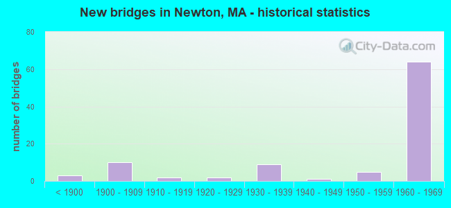
- New bridges - historical statistics
- 3Before 1900
- 101900-1909
- 21910-1919
- 21920-1929
- 91930-1939
- 11940-1949
- 51950-1959
- 641960-1969

- Reconstructed bridges - Historical Statistics
- 11920-1929
- 01930-1939
- 01940-1949
- 41950-1959
- 11960-1969
- 11970-1979
- 81980-1989
- 151990-1999
- 32000-2009
- 12010-2019


- Bridge Condition - Deck
- 49.0%Good
- 20.4%Satisfactory
- 26.5%Fair
- 4.1%Poor

- Bridge Condition - Superstructure
- 25.4%Good
- 35.6%Satisfactory
- 35.6%Fair
- 3.4%Poor

- Bridge Condition - Substructure
- 11.9%Good
- 44.1%Satisfactory
- 40.7%Fair
- 3.4%Poor

- Bridge Condition - Channel
- 68.8%Good
- 31.3%Satisfactory
Find on map >> Show street view
Structure Number: B270044UMMBTNBI, Location: OVER GREEN LINE (Lat: 42.331236, Lng: -71.125822), Route carried "on" structure: City street , Year Built: 1916, Year Reconstructed: 2002, Status: Open, Structure Length: 1.25m (4.10ft), Average Daily Traffic: 18,400 (year 2012), Truck Traffic: 7%, Average Future Daily Traffic: 12,950 (year 2030), Design Load: HS 20, Features Intersected: TR GREEN LINE D, Facility Carried by Structure: HWY CYPRESS ST
Minimum Vertical Clearance: 30+ m (98+ ft), Kilometerpoint: 0.000, Lanes on structure: 2, Owner: State Agenciy, Maintenance Responsibility: State Highway Agency, Approaching Roadway Width: 10.1m (33.1ft), Skew: 1 degrees, Material/Design: Steel, Design/Construction: Stringer/Multi-beam, Number Of Spans In Main Unit: 1, Length of Maximum Span: 10.7m (35.1ft), Curb or Sidewalk Widths: Left: 2.7m (8.9ft), Right: 2.7m (8.9ft), Curb-To-Curb Width: 10.2m (33.5ft), Out-to-Out Width: 15.7m (51.5ft)
Condition: Deck: Good, Superstructure: Good, Substructure: Good, Structural Evaluation: Better than present minimum criteria, Deck Geometry: Meets minimum limits, Underclear: High priority of corrective action, Approach Roadway Alignment: Equal to present minimum criteria, Length Of Structure Improvement: 1.30m (4.27ft), Designated Inspection Frequency: Every 24 months, Inspection Date: June 2021, Bridge Improvement Cost: $393,000, Roadway Improvement Cost: $40,000, Total Project Cost: $590,000 ( Estimate for 2022), Deck Structure Type: Concrete Cast-file-Place, Wearing Surface/Protective System: Wearing Surface: Bituminous
Find on map >> Show street view
Structure Number: N04002362DOTNBI, Location: AT NEWTON T.L. (Lat: 42.306600, Lng: -71.216981), Route carried "on" structure: City street , Year Built: 1875, Status: Open, Structure Length: 2.77m (9.09ft), Average Daily Traffic: 23,534 (year 2019), Truck Traffic: 5%, Average Future Daily Traffic: 60,487 (year 2032), Features Intersected: WATER CHARLES RIVER, Facility Carried by Structure: HWY HIGHLAND AVE
Minimum Vertical Clearance: 30+ m (98+ ft), Kilometerpoint: 0.016, Lanes on structure: 2, Owner: State Highway Agency, Approaching Roadway Width: 8.8m (28.9ft), Material/Design: Masonry, Design/Construction: Arch - Deck, Number Of Spans In Main Unit: 3, Length of Maximum Span: 8.2m (26.9ft), Curb or Sidewalk Widths: Left: 1.8m (5.9ft), Right: 1.4m (4.6ft), Curb-To-Curb Width: 8.8m (28.9ft), Out-to-Out Width: 12.9m (42.3ft)
Condition: Superstructure: Satisfactory, Substructure: Satisfactory, Channel: Good, Operating Rating: 44.1 metric tons, Method Used To Determine Operating Rating: No rating analysis performed, Inventory Rating: 40.3 metric tons, Method Used To Determine Inventory Rating: Allowable Stress (AS), Structural Evaluation: Equal to present minimum criteria, Deck Geometry: High priority of replacement, Waterway Adequacy: Equal to present desirable criteria, Approach Roadway Alignment: Equal to present desirable criteria, Length Of Structure Improvement: 2.80m (9.19ft), Designated Inspection Frequency: Every 24 months, Underwater Inspection Frequency: Every 36 months, Inspection Date: October 2021, Underwater Inspection Date: May 2021, Bridge Improvement Cost: $1,215,000, Roadway Improvement Cost: $122,000, Total Project Cost: $1,823,000 ( Estimate for 2022), Wearing Surface/Protective System: Wearing Surface: Bituminous
Find on map >> Show street view
Structure Number: N0400333QMUNNBI, Location: AT NAHANTON STREET (Lat: 42.297164, Lng: -71.207883), Route carried "on" structure: City street , Year Built: 1959, Year Reconstructed: 1988, Status: Open, Structure Length: 4.94m (16.21ft), Average Daily Traffic: 38,400 (year 2018), Truck Traffic: 2%, Average Future Daily Traffic: 44,694 (year 2031), Design Load: H 20, Features Intersected: WATER CHARLES RIVER, Facility Carried by Structure: HWY KENDRICK ST
Minimum Vertical Clearance: 30+ m (98+ ft), Kilometerpoint: 0.016, Lanes on structure: 2, Owner: Town or Township Highway Agency, Approaching Roadway Width: 12.2m (40.0ft), Skew: 3 degrees, Material/Design: Steel continuous, Design/Construction: Stringer/Multi-beam, Number Of Spans In Main Unit: 3, Length of Maximum Span: 19.4m (63.6ft), Curb or Sidewalk Widths: Left: 1.5m (4.9ft), Right: 0.2m (0.7ft), Curb-To-Curb Width: 12.2m (40.0ft), Out-to-Out Width: 15.0m (49.2ft)
Condition: Deck: Good, Superstructure: Good, Substructure: Satisfactory, Channel: Satisfactory, Operating Rating: 49.7 metric tons, Method Used To Determine Operating Rating: Load Factor (LF), Inventory Rating: 29.8 metric tons, Method Used To Determine Inventory Rating: Load Factor (LF), Structural Evaluation: Equal to present minimum criteria, Deck Geometry: Somewhat better than minimum adequacy, Waterway Adequacy: Equal to present desirable criteria, Approach Roadway Alignment: Equal to present desirable criteria, Length Of Structure Improvement: 5.00m (16.40ft), Designated Inspection Frequency: Every 24 months, Underwater Inspection Frequency: Every 36 months, Inspection Date: July 2020, Underwater Inspection Date: July 2019, Bridge Improvement Cost: $2,947,000, Roadway Improvement Cost: $295,000, Total Project Cost: $4,421,000 ( Estimate for 2022), Deck Structure Type: Concrete Cast-file-Place, Wearing Surface/Protective System: Wearing Surface: Bituminous, Membrane: Built-up
Find on map >> Show street view
Structure Number: N120042EBDOTNBI, Location: NEWTON-WELLESLEY TWN LINE (Lat: 42.316906, Lng: -71.228050), Route carried "on" structure: State highway 9, Year Built: 1900, Year Reconstructed: 1932, Status: Open, Structure Length: 2.32m (7.61ft), Average Daily Traffic: 54,700 (year 2019), Truck Traffic: 4%, Average Future Daily Traffic: 208,468 (year 2032), Design Load: H 20, Features Intersected: WATER CHARLES RIVER
Minimum Vertical Clearance: 30+ m (98+ ft), Kilometerpoint: 204.494, Lanes on structure: 6, Base Highway Network: Yes, Owner: State Highway Agency, Approaching Roadway Width: 18.3m (60.0ft), Skew: 21 degrees, Material/Design: Concrete, Design/Construction: Arch - Deck, Number Of Spans In Main Unit: 2, Length of Maximum Span: 15.2m (49.9ft), Curb or Sidewalk Widths: Left: 1.6m (5.2ft), Right: 1.5m (4.9ft), Curb-To-Curb Width: 7.3m (24.0ft), Out-to-Out Width: 49.1m (161.1ft)
Condition: Superstructure: Fair, Substructure: Satisfactory, Channel: Good, Structural Evaluation: Somewhat better than minimum adequacy, Deck Geometry: High priority of replacement, Waterway Adequacy: Equal to present desirable criteria, Approach Roadway Alignment: Equal to present minimum criteria, Length Of Structure Improvement: 2.40m (7.87ft), Designated Inspection Frequency: Every 24 months, Underwater Inspection Frequency: Every 36 months, Inspection Date: June 2021, Underwater Inspection Date: May 2019, Bridge Improvement Cost: $4,629,000, Roadway Improvement Cost: $463,000, Total Project Cost: $6,944,000 ( Estimate for 2022), Wearing Surface/Protective System: Wearing Surface: Bituminous
Find on map >> Show street view
Structure Number: N120052EHDOTNBI, Location: AT QUINOBEQUIN RD (Lat: 42.316839, Lng: -71.228044), Route carried "on" structure: State highway 9, Year Built: 1932, Status: Open, Structure Length: 0.70m (2.30ft), Average Daily Traffic: 89,700 (year 2018), Truck Traffic: 9%, Average Future Daily Traffic: 136,136 (year 2031), Features Intersected: WATER HEMLOCK GORGE
Minimum Vertical Clearance: 30+ m (98+ ft), Kilometerpoint: 204.494, Lanes on structure: 6, Base Highway Network: Yes, Owner: State Highway Agency, Approaching Roadway Width: 18.3m (60.0ft), Skew: 1 degrees, Material/Design: Concrete, Design/Construction: Arch - Deck, Number Of Spans In Main Unit: 1, Length of Maximum Span: 6.1m (20.0ft), Curb or Sidewalk Widths: Left: 1.5m (4.9ft), Right: 1.5m (4.9ft), Curb-To-Curb Width: 30.2m (99.1ft), Out-to-Out Width: 56.6m (185.7ft)
Condition: Superstructure: Satisfactory, Substructure: Satisfactory, Channel: Good, Structural Evaluation: Equal to present minimum criteria, Deck Geometry: Superior to present desirable criteria, Waterway Adequacy: Equal to present desirable criteria, Approach Roadway Alignment: Better than present minimum criteria, Length Of Structure Improvement: 0.80m (2.62ft), Designated Inspection Frequency: Every 24 months, Underwater Inspection Frequency: Every 36 months, Inspection Date: September 2020, Underwater Inspection Date: September 2019, Bridge Improvement Cost: $356,000, Roadway Improvement Cost: $36,000, Total Project Cost: $535,000 ( Estimate for 2022), Wearing Surface/Protective System: Wearing Surface: Bituminous
Find on map >> Show street view
Structure Number: N120062CPMUNNBI, Location: @ WELLESLEY TL = W13002 (Lat: 42.326744, Lng: -71.253158), Route carried "on" structure: City street , Year Built: 1928, Status: Open, Structure Length: 1.79m (5.87ft), Average Daily Traffic: 22,112 (year 2019), Truck Traffic: 1%, Average Future Daily Traffic: 26,216 (year 2032), Features Intersected: WATER CHARLES RIVER, Facility Carried by Structure: HWY WALES ST
Minimum Vertical Clearance: 30+ m (98+ ft), Kilometerpoint: 0.016, Lanes on structure: 3, Owner: City or Municipal Highway Agency, Approaching Roadway Width: 11.6m (38.1ft), Skew: 1 degrees, Material/Design: Concrete, Design/Construction: Arch - Deck, Number Of Spans In Main Unit: 1, Length of Maximum Span: 17.9m (58.7ft), Curb or Sidewalk Widths: Left: 1.9m (6.2ft), Right: 1.5m (4.9ft), Curb-To-Curb Width: 11.6m (38.1ft), Out-to-Out Width: 16.7m (54.8ft)
Condition: Superstructure: Satisfactory, Substructure: Satisfactory, Channel: Satisfactory, Operating Rating: 38.2 metric tons, Method Used To Determine Operating Rating: Load Factor (LF), Inventory Rating: 22.9 metric tons, Method Used To Determine Inventory Rating: Load Factor (LF), Structural Evaluation: Somewhat better than minimum adequacy, Deck Geometry: High priority of replacement, Waterway Adequacy: Better than present minimum criteria, Approach Roadway Alignment: Somewhat better than minimum adequacy, Length Of Structure Improvement: 1.80m (5.91ft), Designated Inspection Frequency: Every 24 months, Underwater Inspection Frequency: Every 36 months, Inspection Date: August 2021, Underwater Inspection Date: September 2020, Bridge Improvement Cost: $1,181,000, Roadway Improvement Cost: $119,000, Total Project Cost: $1,772,000 ( Estimate for 2022)
Find on map >> Show street view
Structure Number: N120072L9DOTNBI, Location: NEWTON WELLESLEY TWN LINE (Lat: 42.325294, Lng: -71.258503), Route carried "on" structure: State highway 16, Year Built: 1929, Status: Open, Structure Length: 4.30m (14.11ft), Average Daily Traffic: 35,200 (year 2019), Truck Traffic: 4%, Average Future Daily Traffic: 79,597 (year 2032), Features Intersected: WATER CHARLES RIVER
Minimum Vertical Clearance: 30+ m (98+ ft), Kilometerpoint: 0.000, Lanes on structure: 4, Base Highway Network: Yes, Owner: State Highway Agency, Approaching Roadway Width: 14.6m (47.9ft), Material/Design: Concrete, Design/Construction: Arch - Deck, Number Of Spans In Main Unit: 3, Length of Maximum Span: 14.0m (45.9ft), Curb or Sidewalk Widths: Left: 1.8m (5.9ft), Right: 1.8m (5.9ft), Curb-To-Curb Width: 14.6m (47.9ft), Out-to-Out Width: 19.5m (64.0ft)
Condition: Superstructure: Fair, Substructure: Fair, Channel: Satisfactory, Operating Rating: 61.4 metric tons, Method Used To Determine Operating Rating: Load Factor (LF), Inventory Rating: 36.8 metric tons, Method Used To Determine Inventory Rating: Load Factor (LF), Structural Evaluation: Somewhat better than minimum adequacy, Deck Geometry: High priority of replacement, Waterway Adequacy: Better than present minimum criteria, Approach Roadway Alignment: Better than present minimum criteria, Length Of Structure Improvement: 4.40m (14.44ft), Designated Inspection Frequency: Every 24 months, Underwater Inspection Frequency: Every 36 months, Inspection Date: July 2021, Underwater Inspection Date: October 2021, Bridge Improvement Cost: $3,371,000, Roadway Improvement Cost: $338,000, Total Project Cost: $5,057,000 ( Estimate for 2022), Wearing Surface/Protective System: Wearing Surface: Bituminous
Find on map >> Show street view
Structure Number: N120082CMMUNNBI, Location: @ WESTON TL = W29007 (Lat: 42.330567, Lng: -71.267944), Route carried "on" structure: City street , Year Built: 1907, Status: Open, Structure Length: 2.47m (8.10ft), Average Daily Traffic: 6,207 (year 2019), Truck Traffic: 8%, Average Future Daily Traffic: 12,792 (year 2032), Features Intersected: WATER CHARLES RIVER, Facility Carried by Structure: HWY CONCORD ST
Minimum Vertical Clearance: 30+ m (98+ ft), Kilometerpoint: 0.016, Lanes on structure: 2, Owner: City or Municipal Highway Agency, Approaching Roadway Width: 8.2m (26.9ft), Skew: 1 degrees, Material/Design: Concrete, Design/Construction: Arch - Deck, Number Of Spans In Main Unit: 2, Length of Maximum Span: 11.5m (37.7ft), Curb or Sidewalk Widths: Left: 2.0m (6.6ft), Right: 2.0m (6.6ft), Curb-To-Curb Width: 8.2m (26.9ft), Out-to-Out Width: 13.8m (45.3ft)
Condition: Superstructure: Satisfactory, Substructure: Satisfactory, Channel: Satisfactory, Operating Rating: 50.1 metric tons, Method Used To Determine Operating Rating: Load Factor (LF), Inventory Rating: 30.0 metric tons, Method Used To Determine Inventory Rating: Load Factor (LF), Structural Evaluation: Equal to present minimum criteria, Deck Geometry: High priority of replacement, Waterway Adequacy: Better than present minimum criteria, Approach Roadway Alignment: Somewhat better than minimum adequacy, Length Of Structure Improvement: 2.50m (8.20ft), Designated Inspection Frequency: Every 24 months, Underwater Inspection Frequency: Every 36 months, Inspection Date: August 2021, Underwater Inspection Date: September 2020, Bridge Improvement Cost: $1,356,000, Roadway Improvement Cost: $136,000, Total Project Cost: $2,035,000 ( Estimate for 2022), Wearing Surface/Protective System: Wearing Surface: Bituminous
Find on map >> Show street view
Structure Number: N120102K1DOTNBI, Location: NEWTON-WESTON TOWN LINE (Lat: 42.344028, Lng: -71.261353), Route carried "on" structure: State highway 30, Year Built: 1962, Status: Open, Structure Length: 4.21m (13.81ft), Average Daily Traffic: 26,700 (year 2016), Truck Traffic: 2%, Average Future Daily Traffic: 51,485 (year 2032), Design Load: H 20, Features Intersected: WATER CHARLES RIVER
Minimum Vertical Clearance: 30+ m (98+ ft), Kilometerpoint: 6.598, Lanes on structure: 4, Base Highway Network: Yes, Owner: State Highway Agency, Approaching Roadway Width: 10.4m (34.1ft), Skew: 20 degrees, Material/Design: Steel, Design/Construction: Stringer/Multi-beam, Number Of Spans In Main Unit: 1, Length of Maximum Span: 40.5m (132.9ft), Curb or Sidewalk Widths: Left: 0.5m (1.6ft), Right: 1.5m (4.9ft), Curb-To-Curb Width: 10.4m (34.1ft), Out-to-Out Width: 28.3m (92.8ft)
Condition: Deck: Fair, Superstructure: Fair, Substructure: Satisfactory, Channel: Good, Operating Rating: 65.3 metric tons, Method Used To Determine Operating Rating: Load Factor (LF), Inventory Rating: 39.1 metric tons, Method Used To Determine Inventory Rating: Load Factor (LF), Structural Evaluation: Somewhat better than minimum adequacy, Deck Geometry: High priority of replacement, Waterway Adequacy: Equal to present desirable criteria, Approach Roadway Alignment: Better than present minimum criteria, Length Of Structure Improvement: 4.30m (14.11ft), Designated Inspection Frequency: Every 24 months, Inspection Date: Febuary 2021, Bridge Improvement Cost: $4,780,000, Roadway Improvement Cost: $479,000, Total Project Cost: $7,171,000 ( Estimate for 2022), Deck Structure Type: Concrete Cast-file-Place, Wearing Surface/Protective System: Wearing Surface: Bituminous
Find on map >> Show street view
Structure Number: N120112CNMUNNBI, Location: .96 KM E WALTHAM (Lat: 42.365772, Lng: -71.204494), Route carried "on" structure: City street , Year Built: 1967, Status: Open, Structure Length: 2.93m (9.61ft), Average Daily Traffic: 26,600 (year 2018), Truck Traffic: 5%, Average Future Daily Traffic: 37,429 (year 2031), Design Load: H 20, Features Intersected: WATER CHARLES RIVER, Facility Carried by Structure: HWY BRIDGE ST
Minimum Vertical Clearance: 30+ m (98+ ft), Kilometerpoint: 0.595, Lanes on structure: 2, Owner: City or Municipal Highway Agency, Approaching Roadway Width: 12.2m (40.0ft), Material/Design: Prestressed concrete, Design/Construction: Stringer/Multi-beam, Number Of Spans In Main Unit: 1, Length of Maximum Span: 27.4m (89.9ft), Curb or Sidewalk Widths: Left: 1.8m (5.9ft), Right: 1.8m (5.9ft), Curb-To-Curb Width: 12.2m (40.0ft), Out-to-Out Width: 16.7m (54.8ft)
Condition: Deck: Good, Superstructure: Good, Substructure: Satisfactory, Channel: Satisfactory, Operating Rating: 51.6 metric tons, Method Used To Determine Operating Rating: Allowable Stress (AS), Inventory Rating: 32.4 metric tons, Method Used To Determine Inventory Rating: Allowable Stress (AS), Structural Evaluation: Equal to present minimum criteria, Deck Geometry: Somewhat better than minimum adequacy, Waterway Adequacy: Better than present minimum criteria, Approach Roadway Alignment: Equal to present minimum criteria, Length Of Structure Improvement: 3.00m (9.84ft), Designated Inspection Frequency: Every 24 months, Underwater Inspection Frequency: Every 36 months, Inspection Date: August 2020, Underwater Inspection Date: July 2019, Bridge Improvement Cost: $340,000, Roadway Improvement Cost: $35,000, Total Project Cost: $511,000 ( Estimate for 2022), Deck Structure Type: Concrete Cast-file-Place, Wearing Surface/Protective System: Wearing Surface: Bituminous, Membrane: Built-up
Find on map >> Show street view
Structure Number: N120122DDMUNNBI, Location: .96 KM. S. OF I-90 (Lat: 42.341844, Lng: -71.205358), Route carried "on" structure: City street , Year Built: 1898, Year Reconstructed: 2002, Status: Open, Structure Length: 0.82m (2.69ft), Average Daily Traffic: 100 (year 2019), Truck Traffic: 1%, Average Future Daily Traffic: 632 (year 2032), Design Load: HS 20, Features Intersected: WATER LAUNDRY BROOK, Facility Carried by Structure: HWY DEXTER RD
Minimum Vertical Clearance: 30+ m (98+ ft), Kilometerpoint: 0.322, Lanes on structure: 2, Owner: City or Municipal Highway Agency, Approaching Roadway Width: 8.5m (27.9ft), Material/Design: Prestressed concrete, Design/Construction: Slab, Number Of Spans In Main Unit: 1, Length of Maximum Span: 6.6m (21.7ft), Curb or Sidewalk Widths: Left: 1.6m (5.2ft), Right: 1.6m (5.2ft), Curb-To-Curb Width: 8.5m (27.9ft), Out-to-Out Width: 12.7m (41.7ft)
Condition: Deck: Good, Superstructure: Good, Substructure: Good, Channel: Good, Operating Rating: 81.7 metric tons, Method Used To Determine Operating Rating: Load Factor (LF), Inventory Rating: 49.0 metric tons, Method Used To Determine Inventory Rating: Load Factor (LF), Structural Evaluation: Better than present minimum criteria, Deck Geometry: Better than present minimum criteria, Waterway Adequacy: Better than present minimum criteria, Approach Roadway Alignment: Somewhat better than minimum adequacy, Length Of Structure Improvement: 0.90m (2.95ft), Designated Inspection Frequency: Every 24 months, Underwater Inspection Frequency: Every 36 months, Inspection Date: January 2021, Underwater Inspection Date: November 2020, Bridge Improvement Cost: $111,000, Roadway Improvement Cost: $12,000, Total Project Cost: $167,000 ( Estimate for 2022), Deck Structure Type: Concrete Precast Panels, Wearing Surface/Protective System: Wearing Surface: Bituminous, Membrane: Built-up, Deck Protection: Epoxy Coated Reinforcing
Find on map >> Show street view
Structure Number: N120134RADOTNBI, Location: AT INT 17 S33 (Lat: 42.357431, Lng: -71.181128), Route carried "on" structure: Interstate 90, Year Built: 1964, Year Reconstructed: 1993, Status: Open, Structure Length: 8.44m (27.69ft), Average Daily Traffic: 12,413 (year 2022), Truck Traffic: 2%, Average Future Daily Traffic: 1,106 (year 2032), Design Load: H 20, Features Intersected: COMB I 90 & CSX/MBTA, Facility Carried by Structure: HWY ST JAMES ST
Minimum Vertical Clearance: 30+ m (98+ ft), Kilometerpoint: 205.669, Lanes on structure: 2, Lanes under structure: 8, Owner: State Highway Agency, Approaching Roadway Width: 8.5m (27.9ft), Skew: 4 degrees, Material/Design: Steel, Design/Construction: Stringer/Multi-beam, Number Of Spans In Main Unit: 4, Length of Maximum Span: 21.0m (68.9ft), Curb or Sidewalk Widths: Left: 1.8m (5.9ft), Right: 1.8m (5.9ft), Curb-To-Curb Width: 8.5m (27.9ft), Out-to-Out Width: 12.9m (42.3ft)
Condition: Deck: Fair, Superstructure: Satisfactory, Substructure: Fair, Operating Rating: 58.1 metric tons, Method Used To Determine Operating Rating: Load Factor (LF), Inventory Rating: 34.8 metric tons, Method Used To Determine Inventory Rating: Load Factor (LF), Structural Evaluation: Somewhat better than minimum adequacy, Deck Geometry: Meets minimum limits, Underclear: High priority of corrective action, Approach Roadway Alignment: Equal to present desirable criteria, Length Of Structure Improvement: 8.50m (27.89ft), Designated Inspection Frequency: Every 24 months, Inspection Date: January 2022, Bridge Improvement Cost: $4,308,000, Roadway Improvement Cost: $431,000, Total Project Cost: $6,463,000 ( Estimate for 2022), Deck Structure Type: Concrete Cast-file-Place, Wearing Surface/Protective System: Wearing Surface: Monolithic Concrete
Find on map >> Show street view
Structure Number: N120144R8DOTNBI, Location: AT INT 17 S31 (Lat: 42.356822, Lng: -71.183692), Route carried "on" structure: Interstate 90, Year Built: 1964, Year Reconstructed: 1995, Status: Open, Structure Length: 6.71m (22.01ft), Average Daily Traffic: 25,603 (year 2022), Truck Traffic: 9%, Average Future Daily Traffic: 21,478 (year 2032), Design Load: HS 20, Features Intersected: COMB I 90 & CSX/MBTA, Facility Carried by Structure: HWY WASHNGTON ST
Minimum Vertical Clearance: 30+ m (98+ ft), Kilometerpoint: 205.508, Lanes on structure: 5, Lanes under structure: 6, Base Highway Network: Yes, Owner: State Highway Agency, Approaching Roadway Width: 9.1m (29.9ft), Skew: 1 degrees, Material/Design: Steel, Design/Construction: Stringer/Multi-beam, Number Of Spans In Main Unit: 4, Length of Maximum Span: 17.1m (56.1ft), Curb or Sidewalk Widths: Left: 3.0m (9.8ft), Right: 3.0m (9.8ft), Curb-To-Curb Width: 18.3m (60.0ft), Out-to-Out Width: 25.1m (82.3ft)
Condition: Deck: Good, Superstructure: Fair, Substructure: Fair, Operating Rating: 82.9 metric tons, Method Used To Determine Operating Rating: Load Factor (LF), Inventory Rating: 49.7 metric tons, Method Used To Determine Inventory Rating: Load Factor (LF), Structural Evaluation: Somewhat better than minimum adequacy, Deck Geometry: High priority of replacement, Underclear: High priority of corrective action, Approach Roadway Alignment: Equal to present desirable criteria, Length Of Structure Improvement: 6.80m (22.31ft), Designated Inspection Frequency: Every 24 months, Inspection Date: January 2022, Bridge Improvement Cost: $6,705,000, Roadway Improvement Cost: $671,000, Total Project Cost: $10,058,000 ( Estimate for 2022), Deck Structure Type: Concrete Cast-file-Place, Wearing Surface/Protective System: Wearing Surface: Monolithic Concrete
Find on map >> Show street view
Structure Number: N120154QXDOTNBI, Location: AT INT 16 S17 (Lat: 42.347831, Lng: -71.228919), Route carried "on" structure: Interstate 90, Year Built: 1964, Year Reconstructed: 1996, Status: Open, Structure Length: 6.40m (21.00ft), Average Daily Traffic: 17,198 (year 2020), Truck Traffic: 2%, Average Future Daily Traffic: 21,478 (year 2031), Design Load: HS 20, Features Intersected: COMB I 90 & CSX/MBTA, Facility Carried by Structure: ST 16 EB/WSHGTN ST
Minimum Vertical Clearance: 30+ m (98+ ft), Kilometerpoint: 201.645, Lanes on structure: 3, Lanes under structure: 7, Base Highway Network: Yes, Owner: State Highway Agency, Approaching Roadway Width: 14.6m (47.9ft), Material/Design: Steel, Design/Construction: Stringer/Multi-beam, Number Of Spans In Main Unit: 4, Length of Maximum Span: 16.8m (55.1ft), Curb or Sidewalk Widths: Left: 2.4m (7.9ft), Right: 2.4m (7.9ft), Curb-To-Curb Width: 14.6m (47.9ft), Out-to-Out Width: 20.2m (66.3ft)
Condition: Deck: Good, Superstructure: Poor, Substructure: Fair, Operating Rating: 63.7 metric tons, Method Used To Determine Operating Rating: Allowable Stress (AS), Inventory Rating: 38.2 metric tons, Method Used To Determine Inventory Rating: Allowable Stress (AS), Structural Evaluation: Meets minimum limits, Deck Geometry: Somewhat better than minimum adequacy, Underclear: High priority of corrective action, Approach Roadway Alignment: Equal to present desirable criteria, Length Of Structure Improvement: 6.50m (21.33ft), Designated Inspection Frequency: Every 12 months, Other Special Inspection Frequency: Every 12 months, Inspection Date: January 2022, Other Special Inspection Date: January 2022, Bridge Improvement Cost: $5,158,000, Roadway Improvement Cost: $516,000, Total Project Cost: $7,738,000 ( Estimate for 2022), Deck Structure Type: Concrete Cast-file-Place, Wearing Surface/Protective System: Wearing Surface: Monolithic Concrete
Find on map >> Show street view
Structure Number: N120164R6DOTNBI, Location: AT INT 17 S28 (Lat: 42.355875, Lng: -71.188056), Route carried "on" structure: Interstate 90, Year Built: 1964, Year Reconstructed: 1995, Status: Open, Structure Length: 5.12m (16.80ft), Average Daily Traffic: 25,086 (year 2022), Truck Traffic: 7%, Average Future Daily Traffic: 21,478 (year 2032), Design Load: HS 20, Features Intersected: COMB I 90 & CSX/MBTA, Facility Carried by Structure: HWY CENTRE ST
Minimum Vertical Clearance: 30+ m (98+ ft), Kilometerpoint: 205.025, Lanes on structure: 4, Lanes under structure: 8, Owner: State Highway Agency, Approaching Roadway Width: 17.7m (58.1ft), Material/Design: Steel, Design/Construction: Stringer/Multi-beam, Number Of Spans In Main Unit: 3, Length of Maximum Span: 21.9m (71.9ft), Curb or Sidewalk Widths: Left: 3.0m (9.8ft), Right: 3.0m (9.8ft), Curb-To-Curb Width: 17.7m (58.1ft), Out-to-Out Width: 24.4m (80.1ft)
Condition: Deck: Satisfactory, Superstructure: Good, Substructure: Fair, Operating Rating: 54.8 metric tons, Method Used To Determine Operating Rating: Load Factor (LF), Inventory Rating: 32.6 metric tons, Method Used To Determine Inventory Rating: Load Factor (LF), Structural Evaluation: Somewhat better than minimum adequacy, Deck Geometry: Somewhat better than minimum adequacy, Underclear: High priority of corrective action, Approach Roadway Alignment: Equal to present desirable criteria, Length Of Structure Improvement: 5.20m (17.06ft), Designated Inspection Frequency: Every 24 months, Inspection Date: January 2022, Bridge Improvement Cost: $4,984,000, Roadway Improvement Cost: $499,000, Total Project Cost: $7,477,000 ( Estimate for 2022), Deck Structure Type: Concrete Cast-file-Place, Wearing Surface/Protective System: Wearing Surface: Monolithic Concrete
Find on map >> Show street view
Structure Number: N120174R5DOTNBI, Location: .48 KM S. CHARLES RV S26 (Lat: 42.355508, Lng: -71.190181), Route carried "on" structure: Interstate 90, Year Built: 1964, Status: Open, Structure Length: 5.55m (18.21ft), Average Daily Traffic: 10,344 (year 2019), Truck Traffic: 7%, Average Future Daily Traffic: 12,161 (year 2032), Design Load: HS 20, Features Intersected: COMB I 90 & CSX/MBTA, Facility Carried by Structure: HWY CHURCH ST
Minimum Vertical Clearance: 30+ m (98+ ft), Kilometerpoint: 204.864, Lanes on structure: 4, Lanes under structure: 6, Owner: State Highway Agency, Approaching Roadway Width: 17.1m (56.1ft), Skew: 1 degrees, Material/Design: Steel, Design/Construction: Stringer/Multi-beam, Number Of Spans In Main Unit: 3, Length of Maximum Span: 18.9m (62.0ft), Curb or Sidewalk Widths: Left: 2.4m (7.9ft), Right: 2.4m (7.9ft), Curb-To-Curb Width: 17.1m (56.1ft), Out-to-Out Width: 22.6m (74.1ft)
Condition: Deck: Good, Superstructure: Fair, Substructure: Satisfactory, Operating Rating: 82.7 metric tons, Method Used To Determine Operating Rating: Load Factor (LF), Inventory Rating: 50.4 metric tons, Method Used To Determine Inventory Rating: Load Factor (LF), Structural Evaluation: Somewhat better than minimum adequacy, Deck Geometry: Somewhat better than minimum adequacy, Underclear: High priority of corrective action, Approach Roadway Alignment: Equal to present desirable criteria, Length Of Structure Improvement: 5.60m (18.37ft), Designated Inspection Frequency: Every 24 months, Inspection Date: March 2021, Bridge Improvement Cost: $4,972,000, Roadway Improvement Cost: $498,000, Total Project Cost: $7,459,000 ( Estimate for 2022), Deck Structure Type: Concrete Cast-file-Place, Wearing Surface/Protective System: Wearing Surface: Monolithic Concrete
Find on map >> Show street view
Structure Number: N120194R4DOTNBI, Location: .8 KM S. CHARLES RV S25 (Lat: 42.353878, Lng: -71.196844), Route carried "on" structure: Interstate 90, Year Built: 1964, Year Reconstructed: 1994, Status: Open, Structure Length: 5.88m (19.29ft), Average Daily Traffic: 8,100 (year 2020), Truck Traffic: 2%, Average Future Daily Traffic: 4,738 (year 2031), Design Load: H 20, Features Intersected: COMB I 90 & CSX/MBTA, Facility Carried by Structure: HWY LEWIS TER
Minimum Vertical Clearance: 30+ m (98+ ft), Kilometerpoint: 204.381, Lanes on structure: 2, Lanes under structure: 6, Owner: State Highway Agency, Approaching Roadway Width: 8.5m (27.9ft), Material/Design: Steel, Design/Construction: Stringer/Multi-beam, Number Of Spans In Main Unit: 3, Length of Maximum Span: 25.6m (84.0ft), Curb or Sidewalk Widths: Left: 1.8m (5.9ft), Right: 1.8m (5.9ft), Curb-To-Curb Width: 8.5m (27.9ft), Out-to-Out Width: 12.9m (42.3ft)
Condition: Deck: Good, Superstructure: Satisfactory, Substructure: Fair, Operating Rating: 45.7 metric tons, Method Used To Determine Operating Rating: Load Factor (LF), Inventory Rating: 33.5 metric tons, Method Used To Determine Inventory Rating: Load Factor (LF), Structural Evaluation: Somewhat better than minimum adequacy, Deck Geometry: High priority of replacement, Underclear: High priority of corrective action, Approach Roadway Alignment: Equal to present desirable criteria, Length Of Structure Improvement: 5.90m (19.36ft), Designated Inspection Frequency: Every 24 months, Inspection Date: Febuary 2020, Bridge Improvement Cost: $2,990,000, Roadway Improvement Cost: $300,000, Total Project Cost: $4,486,000 ( Estimate for 2022), Deck Structure Type: Concrete Cast-file-Place, Wearing Surface/Protective System: Wearing Surface: Monolithic Concrete
Find on map >> Show street view
Structure Number: N120204R3DOTNBI, Location: .8 KM S. CHARLES RV S24 (Lat: 42.352428, Lng: -71.202106), Route carried "on" structure: Interstate 90, Year Built: 1964, Year Reconstructed: 2010, Status: Open, Structure Length: 5.51m (18.08ft), Average Daily Traffic: 5,000 (year 2019), Truck Traffic: 5%, Average Future Daily Traffic: 1,106 (year 2032), Design Load: H 20, Features Intersected: COMB I 90 & CSX/MBTA, Facility Carried by Structure: HWY HARVARD ST
Minimum Vertical Clearance: 30+ m (98+ ft), Kilometerpoint: 203.898, Lanes on structure: 2, Lanes under structure: 6, Owner: State Highway Agency, Approaching Roadway Width: 8.5m (27.9ft), Material/Design: Steel, Design/Construction: Stringer/Multi-beam, Number Of Spans In Main Unit: 3, Length of Maximum Span: 21.5m (70.5ft), Curb or Sidewalk Widths: Left: 1.8m (5.9ft), Right: 1.8m (5.9ft), Curb-To-Curb Width: 8.5m (27.9ft), Out-to-Out Width: 12.9m (42.3ft)
Condition: Deck: Good, Superstructure: Fair, Substructure: Good, Operating Rating: 41.1 metric tons, Method Used To Determine Operating Rating: Load Factor (LF), Inventory Rating: 38.2 metric tons, Method Used To Determine Inventory Rating: Load Factor (LF), Structural Evaluation: Somewhat better than minimum adequacy, Deck Geometry: Meets minimum limits, Underclear: High priority of corrective action, Approach Roadway Alignment: High priority of corrective action, Length Of Structure Improvement: 5.60m (18.37ft), Designated Inspection Frequency: Every 24 months, Inspection Date: July 2021, Bridge Improvement Cost: $2,838,000, Roadway Improvement Cost: $284,000, Total Project Cost: $4,258,000 ( Estimate for 2022), Deck Structure Type: Concrete Cast-file-Place, Wearing Surface/Protective System: Wearing Surface: Monolithic Concrete, Deck Protection: Epoxy Coated Reinforcing
Find on map >> Show street view
Structure Number: N120214R2DOTNBI, Location: .8 KM S. CHARLES RV S23 (Lat: 42.351244, Lng: -71.207175), Route carried "on" structure: Interstate 90, Year Built: 1964, Year Reconstructed: 1994, Status: Open, Structure Length: 4.53m (14.86ft), Average Daily Traffic: 20,600 (year 2018), Truck Traffic: 8%, Average Future Daily Traffic: 21,478 (year 2031), Design Load: HS 20, Features Intersected: COMB I 90 & CSX/MBTA, Facility Carried by Structure: HWY WALNUT ST
Minimum Vertical Clearance: 30+ m (98+ ft), Kilometerpoint: 203.416, Lanes on structure: 4, Lanes under structure: 6, Owner: State Highway Agency, Approaching Roadway Width: 23.2m (76.1ft), Skew: 20 degrees, Material/Design: Steel, Design/Construction: Stringer/Multi-beam, Number Of Spans In Main Unit: 3, Length of Maximum Span: 16.0m (52.5ft), Curb or Sidewalk Widths: Left: 3.5m (11.5ft), Right: 3.5m (11.5ft), Curb-To-Curb Width: 23.2m (76.1ft), Out-to-Out Width: 31.1m (102.0ft)
Condition: Deck: Satisfactory, Superstructure: Satisfactory, Substructure: Fair, Operating Rating: 59.8 metric tons, Method Used To Determine Operating Rating: Load Factor (LF), Inventory Rating: 40.5 metric tons, Method Used To Determine Inventory Rating: Load Factor (LF), Structural Evaluation: Somewhat better than minimum adequacy, Deck Geometry: Superior to present desirable criteria, Underclear: High priority of corrective action, Approach Roadway Alignment: Equal to present desirable criteria, Length Of Structure Improvement: 4.60m (15.09ft), Designated Inspection Frequency: Every 24 months, Inspection Date: June 2020, Bridge Improvement Cost: $5,620,000, Roadway Improvement Cost: $563,000, Total Project Cost: $8,431,000 ( Estimate for 2022), Deck Structure Type: Concrete Cast-file-Place, Wearing Surface/Protective System: Wearing Surface: Monolithic Concrete
Find on map >> Show street view
Structure Number: N120224R1DOTNBI, Location: .8 KM S. CHARLES RV S22 (Lat: 42.350678, Lng: -71.210781), Route carried "on" structure: Interstate 90, Year Built: 1964, Year Reconstructed: 1994, Status: Open, Structure Length: 6.10m (20.01ft), Average Daily Traffic: 14,500 (year 2020), Truck Traffic: 7%, Average Future Daily Traffic: 4,738 (year 2031), Design Load: H 20, Features Intersected: COMB I 90 & CSX/MBTA, Facility Carried by Structure: HWY LOWELL AVE
Minimum Vertical Clearance: 30+ m (98+ ft), Kilometerpoint: 203.094, Lanes on structure: 2, Lanes under structure: 6, Owner: State Highway Agency, Approaching Roadway Width: 10.4m (34.1ft), Skew: 6 degrees, Material/Design: Steel, Design/Construction: Stringer/Multi-beam, Number Of Spans In Main Unit: 3, Length of Maximum Span: 20.7m (67.9ft), Curb or Sidewalk Widths: Left: 2.3m (7.5ft), Right: 2.3m (7.5ft), Curb-To-Curb Width: 10.4m (34.1ft), Out-to-Out Width: 15.9m (52.2ft)
Condition: Deck: Satisfactory, Superstructure: Satisfactory, Substructure: Fair, Operating Rating: 64.1 metric tons, Method Used To Determine Operating Rating: Load Factor (LF), Inventory Rating: 40.1 metric tons, Method Used To Determine Inventory Rating: Load Factor (LF), Structural Evaluation: Somewhat better than minimum adequacy, Deck Geometry: Meets minimum limits, Underclear: High priority of corrective action, Approach Roadway Alignment: Equal to present desirable criteria, Length Of Structure Improvement: 6.20m (20.34ft), Designated Inspection Frequency: Every 24 months, Inspection Date: Febuary 2020, Bridge Improvement Cost: $3,873,000, Roadway Improvement Cost: $388,000, Total Project Cost: $5,810,000 ( Estimate for 2022), Deck Structure Type: Concrete Cast-file-Place, Wearing Surface/Protective System: Wearing Surface: Monolithic Concrete
Find on map >> Show street view
Structure Number: N120254R0DOTNBI, Location: .8 KM W. ARMORY S19 (Lat: 42.348269, Lng: -71.225169), Route carried "on" structure: Interstate 90, Year Built: 1964, Year Reconstructed: 1994, Status: Open, Structure Length: 4.75m (15.58ft), Average Daily Traffic: 9,827 (year 2020), Truck Traffic: 8%, Average Future Daily Traffic: 12,161 (year 2031), Design Load: H 20, Features Intersected: COMB I 90 & CSX/MBTA, Facility Carried by Structure: HWY CHESTNUT ST
Minimum Vertical Clearance: 30+ m (98+ ft), Kilometerpoint: 201.967, Lanes on structure: 2, Lanes under structure: 6, Owner: State Highway Agency, Approaching Roadway Width: 10.4m (34.1ft), Material/Design: Steel, Design/Construction: Stringer/Multi-beam, Number Of Spans In Main Unit: 3, Length of Maximum Span: 18.5m (60.7ft), Curb or Sidewalk Widths: Left: 2.3m (7.5ft), Right: 2.3m (7.5ft), Curb-To-Curb Width: 10.4m (34.1ft), Out-to-Out Width: 15.9m (52.2ft)
Condition: Deck: Satisfactory, Superstructure: Satisfactory, Substructure: Fair, Operating Rating: 68.9 metric tons, Method Used To Determine Operating Rating: Load Factor (LF), Inventory Rating: 41.2 metric tons, Method Used To Determine Inventory Rating: Load Factor (LF), Structural Evaluation: Somewhat better than minimum adequacy, Deck Geometry: Somewhat better than minimum adequacy, Underclear: High priority of corrective action, Approach Roadway Alignment: Better than present minimum criteria, Length Of Structure Improvement: 4.80m (15.75ft), Designated Inspection Frequency: Every 24 months, Inspection Date: Febuary 2020, Bridge Improvement Cost: $2,998,000, Roadway Improvement Cost: $300,000, Total Project Cost: $4,498,000 ( Estimate for 2022), Deck Structure Type: Concrete Cast-file-Place, Wearing Surface/Protective System: Wearing Surface: Latex Concrete, Deck Protection: Epoxy Coated Reinforcing
Find on map >> Show street view
Structure Number: N120264QYDOTNBI, Location: .16 KM S. ST16 S18 (Lat: 42.348022, Lng: -71.226981), Route carried "on" structure: Interstate 90, Year Built: 1964, Year Reconstructed: 1994, Status: Posted for load, Structure Length: 5.21m (17.09ft), Average Daily Traffic: 4,913 (year 2020), Truck Traffic: 5%, Average Future Daily Traffic: 1,106 (year 2031), Design Load: H 20, Features Intersected: COMB I 90 & CSX/MBTA, Facility Carried by Structure: HWY HIGHLAND ST
Minimum Vertical Clearance: 30+ m (98+ ft), Kilometerpoint: 201.806, Lanes on structure: 2, Lanes under structure: 6, Owner: State Highway Agency, Approaching Roadway Width: 9.1m (29.9ft), Skew: 1 degrees, Material/Design: Steel, Design/Construction: Stringer/Multi-beam, Number Of Spans In Main Unit: 3, Length of Maximum Span: 18.6m (61.0ft), Curb or Sidewalk Widths: Left: 1.7m (5.6ft), Right: 1.7m (5.6ft), Curb-To-Curb Width: 9.1m (29.9ft), Out-to-Out Width: 13.5m (44.3ft)
Condition: Deck: Satisfactory, Superstructure: Fair, Substructure: Fair, Operating Rating: 55.3 metric tons, Method Used To Determine Operating Rating: Load Factor (LF), Inventory Rating: 36.6 metric tons, Method Used To Determine Inventory Rating: Load Factor (LF), Structural Evaluation: Somewhat better than minimum adequacy, Deck Geometry: Meets minimum limits, Underclear: High priority of corrective action, Approach Roadway Alignment: Equal to present desirable criteria, Length Of Structure Improvement: 5.30m (17.39ft), Designated Inspection Frequency: Every 24 months, Inspection Date: Febuary 2020, Bridge Improvement Cost: $2,811,000, Roadway Improvement Cost: $282,000, Total Project Cost: $4,217,000 ( Estimate for 2022), Deck Structure Type: Concrete Cast-file-Place, Wearing Surface/Protective System: Wearing Surface: Latex Concrete, Deck Protection: Epoxy Coated Reinforcing
Find on map >> Show street view
Structure Number: N120274QWDOTNBI, Location: AT INT 16 S16 (Lat: 42.347644, Lng: -71.232056), Route carried "on" structure: Interstate 90, Year Built: 1964, Status: Open, Structure Length: 5.18m (16.99ft), Average Daily Traffic: 25,100 (year 2019), Truck Traffic: 6%, Average Future Daily Traffic: 21,478 (year 2032), Design Load: HS 20, Features Intersected: COMB I 90 & CSX/MBTA, Facility Carried by Structure: ST 16 WB/WSHGTN ST
Minimum Vertical Clearance: 4.42m (14.50ft), Kilometerpoint: 201.340, Lanes on structure: 5, Lanes under structure: 7, Base Highway Network: Yes, Owner: State Highway Agency, Approaching Roadway Width: 21.9m (71.9ft), Skew: 20 degrees, Material/Design: Steel, Design/Construction: Stringer/Multi-beam, Number Of Spans In Main Unit: 3, Length of Maximum Span: 21.5m (70.5ft), Curb or Sidewalk Widths: Left: 2.4m (7.9ft), Right: 2.4m (7.9ft), Curb-To-Curb Width: 21.9m (71.9ft), Out-to-Out Width: 28.6m (93.8ft)
Condition: Deck: Poor, Superstructure: Fair, Substructure: Fair, Operating Rating: 56.3 metric tons, Method Used To Determine Operating Rating: Load Factor (LF), Inventory Rating: 33.7 metric tons, Method Used To Determine Inventory Rating: Load Factor (LF), Structural Evaluation: Somewhat better than minimum adequacy, Deck Geometry: Meets minimum limits, Underclear: High priority of corrective action, Approach Roadway Alignment: Equal to present desirable criteria, Length Of Structure Improvement: 5.20m (17.06ft), Designated Inspection Frequency: Every 12 months, Other Special Inspection Frequency: Every 12 months, Inspection Date: July 2021, Other Special Inspection Date: July 2021, Bridge Improvement Cost: $5,842,000, Roadway Improvement Cost: $585,000, Total Project Cost: $8,764,000 ( Estimate for 2022), Deck Structure Type: Concrete Cast-file-Place, Wearing Surface/Protective System: Wearing Surface: Monolithic Concrete
Find on map >> Show street view
Structure Number: N120294QRDOTNBI, Location: .64 KM W. INT 16 S14 (Lat: 42.346694, Lng: -71.242181), Route carried "on" structure: Interstate 90, Year Built: 1964, Status: Open, Structure Length: 5.70m (18.70ft), Average Daily Traffic: 16,163 (year 2020), Truck Traffic: 2%, Average Future Daily Traffic: 21,478 (year 2031), Design Load: HS 20, Features Intersected: COMB I 90 & CSX/MBTA, Facility Carried by Structure: ST 30 COMM AVE
Minimum Vertical Clearance: 30+ m (98+ ft), Kilometerpoint: 200.519, Lanes on structure: 2, Lanes under structure: 6, Base Highway Network: Yes, Owner: State Highway Agency, Approaching Roadway Width: 11.0m (36.1ft), Skew: 3 degrees, Material/Design: Steel, Design/Construction: Stringer/Multi-beam, Number Of Spans In Main Unit: 3, Length of Maximum Span: 20.3m (66.6ft), Curb or Sidewalk Widths: Left: 3.6m (11.8ft), Right: 0.6m (2.0ft), Curb-To-Curb Width: 11.0m (36.1ft), Out-to-Out Width: 16.2m (53.1ft)
Condition: Deck: Good, Superstructure: Satisfactory, Substructure: Fair, Operating Rating: 84.9 metric tons, Method Used To Determine Operating Rating: Load Factor (LF), Inventory Rating: 50.8 metric tons, Method Used To Determine Inventory Rating: Load Factor (LF), Structural Evaluation: Somewhat better than minimum adequacy, Deck Geometry: Meets minimum limits, Underclear: High priority of corrective action, Approach Roadway Alignment: Equal to present desirable criteria, Length Of Structure Improvement: 5.80m (19.03ft), Designated Inspection Frequency: Every 24 months, Inspection Date: January 2022, Bridge Improvement Cost: $3,691,000, Roadway Improvement Cost: $370,000, Total Project Cost: $5,537,000 ( Estimate for 2022), Deck Structure Type: Concrete Cast-file-Place, Wearing Surface/Protective System: Wearing Surface: Monolithic Concrete
Find on map >> Show street view
Structure Number: N120294QTDOTNBI, Location: .4 MI W. INT 16 S14 B (Lat: 42.346733, Lng: -71.241864), Route carried "on" structure: Interstate 90, Year Built: 1964, Status: Open, Structure Length: 5.70m (18.70ft), Average Daily Traffic: 100 (year 2020), Truck Traffic: 1%, Average Future Daily Traffic: 1,106 (year 2031), Design Load: HS 20, Features Intersected: COMB I 90 & CSX/MBTA, Facility Carried by Structure: ST 30 WB SERVCE RD
Minimum Vertical Clearance: 30+ m (98+ ft), Kilometerpoint: 200.599, Lanes on structure: 2, Lanes under structure: 6, Owner: State Highway Agency, Approaching Roadway Width: 11.0m (36.1ft), Skew: 3 degrees, Material/Design: Steel, Design/Construction: Stringer/Multi-beam, Number Of Spans In Main Unit: 3, Length of Maximum Span: 20.3m (66.6ft), Curb or Sidewalk Widths: Left: 3.0m (9.8ft), Right: 0.6m (2.0ft), Curb-To-Curb Width: 11.0m (36.1ft), Out-to-Out Width: 15.3m (50.2ft)
Condition: Deck: Fair, Superstructure: Satisfactory, Substructure: Fair, Operating Rating: 61.8 metric tons, Method Used To Determine Operating Rating: Load Factor (LF), Inventory Rating: 37.0 metric tons, Method Used To Determine Inventory Rating: Load Factor (LF), Structural Evaluation: Somewhat better than minimum adequacy, Deck Geometry: Superior to present desirable criteria, Underclear: High priority of corrective action, Approach Roadway Alignment: Equal to present desirable criteria, Length Of Structure Improvement: 5.80m (19.03ft), Designated Inspection Frequency: Every 24 months, Inspection Date: January 2022, Bridge Improvement Cost: $3,486,000, Roadway Improvement Cost: $349,000, Total Project Cost: $5,230,000 ( Estimate for 2022), Deck Structure Type: Concrete Cast-file-Place, Wearing Surface/Protective System: Wearing Surface: Monolithic Concrete
Find on map >> Show street view
Structure Number: N120304QQDOTNBI, Location: .16 KM S. ST 30 (Lat: 42.346197, Lng: -71.246767), Route carried "on" structure: Interstate 90, Year Built: 1964, Year Reconstructed: 1995, Status: Open, Structure Length: 5.65m (18.54ft), Average Daily Traffic: 9,440 (year 2021), Truck Traffic: 3%, Average Future Daily Traffic: 4,738 (year 2032), Design Load: HS 20, Features Intersected: COMB I 90 & CSX/MBTA, Facility Carried by Structure: HWY AUBURN ST
Minimum Vertical Clearance: 30+ m (98+ ft), Kilometerpoint: 200.036, Lanes on structure: 2, Lanes under structure: 6, Owner: State Highway Agency, Approaching Roadway Width: 12.2m (40.0ft), Skew: 1 degrees, Material/Design: Steel, Design/Construction: Stringer/Multi-beam, Number Of Spans In Main Unit: 3, Length of Maximum Span: 23.3m (76.4ft), Curb or Sidewalk Widths: Left: 3.0m (9.8ft), Right: 3.0m (9.8ft), Curb-To-Curb Width: 12.2m (40.0ft), Out-to-Out Width: 18.9m (62.0ft)
Condition: Deck: Fair, Superstructure: Satisfactory, Substructure: Fair, Operating Rating: 74.5 metric tons, Method Used To Determine Operating Rating: Load Factor (LF), Inventory Rating: 45.2 metric tons, Method Used To Determine Inventory Rating: Load Factor (LF), Structural Evaluation: Somewhat better than minimum adequacy, Deck Geometry: Somewhat better than minimum adequacy, Underclear: High priority of corrective action, Approach Roadway Alignment: Equal to present desirable criteria, Length Of Structure Improvement: 5.70m (18.70ft), Designated Inspection Frequency: Every 24 months, Inspection Date: December 2021, Bridge Improvement Cost: $4,232,000, Roadway Improvement Cost: $424,000, Total Project Cost: $6,349,000 ( Estimate for 2022), Deck Structure Type: Concrete Cast-file-Place, Wearing Surface/Protective System: Wearing Surface: Monolithic Concrete
Find on map >> Show street view
Structure Number: N120314QPDOTNBI, Location: .32 KM E. CHARLES RV (Lat: 42.344914, Lng: -71.252044), Route carried "on" structure: Interstate 90, Year Built: 1964, Year Reconstructed: 1995, Status: Open, Structure Length: 7.77m (25.49ft), Average Daily Traffic: 3,103 (year 2021), Truck Traffic: 4%, Average Future Daily Traffic: 1,106 (year 2032), Design Load: HS 20, Features Intersected: COMB I 90 & CSX/MBTA, Facility Carried by Structure: HWY WOODLAND RD
Minimum Vertical Clearance: 30+ m (98+ ft), Kilometerpoint: 199.553, Lanes on structure: 2, Lanes under structure: 6, Owner: State Highway Agency, Approaching Roadway Width: 8.5m (27.9ft), Material/Design: Steel, Design/Construction: Stringer/Multi-beam, Number Of Spans In Main Unit: 4, Length of Maximum Span: 24.7m (81.0ft), Curb or Sidewalk Widths: Left: 1.8m (5.9ft), Right: 1.8m (5.9ft), Curb-To-Curb Width: 8.5m (27.9ft), Out-to-Out Width: 12.9m (42.3ft)
Condition: Deck: Good, Superstructure: Satisfactory, Substructure: Fair, Operating Rating: 74.2 metric tons, Method Used To Determine Operating Rating: Load Factor (LF), Inventory Rating: 40.2 metric tons, Method Used To Determine Inventory Rating: Load Factor (LF), Structural Evaluation: Somewhat better than minimum adequacy, Deck Geometry: Meets minimum limits, Underclear: High priority of corrective action, Approach Roadway Alignment: Equal to present desirable criteria, Length Of Structure Improvement: 7.80m (25.59ft), Designated Inspection Frequency: Every 24 months, Inspection Date: December 2021, Bridge Improvement Cost: $3,953,000, Roadway Improvement Cost: $396,000, Total Project Cost: $5,930,000 ( Estimate for 2022), Deck Structure Type: Concrete Cast-file-Place, Wearing Surface/Protective System: Wearing Surface: Monolithic Concrete
Find on map >> Show street view
Structure Number: N120324TUMBTNBI, Location: 0.28 MI NOTH OF RTE 9 (Lat: 42.326694, Lng: -71.165497), Route carried "on" structure: City street , Year Built: 1900, Year Reconstructed: 1991, Status: Open, Structure Length: 1.80m (5.91ft), Average Daily Traffic: 3,000 (year 1997), Truck Traffic: 1%, Average Future Daily Traffic: 4,738 (year 2031), Design Load: H 20, Features Intersected: TR GREEN LINE D, Facility Carried by Structure: HWY HAMMOND ST
Minimum Vertical Clearance: 30+ m (98+ ft), Kilometerpoint: 0.000, Lanes on structure: 2, Owner: State Agenciy, Maintenance Responsibility: State Highway Agency, Approaching Roadway Width: 7.0m (23.0ft), Material/Design: Steel, Design/Construction: Truss - Thru, Number Of Spans In Main Unit: 1, Length of Maximum Span: 17.0m (55.8ft), Curb or Sidewalk Widths: Left: 1.7m (5.6ft), Right: 1.7m (5.6ft), Curb-To-Curb Width: 7.0m (23.0ft), Out-to-Out Width: 12.2m (40.0ft)
Condition: Deck: Fair, Superstructure: Satisfactory, Substructure: Good, Operating Rating: 58.8 metric tons, Method Used To Determine Operating Rating: Load Factor (LF), Inventory Rating: 35.2 metric tons, Method Used To Determine Inventory Rating: Load Factor (LF), Structural Evaluation: Equal to present minimum criteria, Deck Geometry: High priority of replacement, Underclear: High priority of replacement, Approach Roadway Alignment: High priority of corrective action, Length Of Structure Improvement: 2.60m (8.53ft), Designated Inspection Frequency: Every 24 months, Critical Feature Inspection Frequency: Every 24 months, Inspection Date: July 2021, Critical Feature Inspection Date: July 2019, Bridge Improvement Cost: $2,532,000, Roadway Improvement Cost: $254,000, Total Project Cost: $3,799,000 ( Estimate for 2022), Deck Structure Type: Closed Grating, Wearing Surface/Protective System: Wearing Surface: Bituminous, Membrane: Epoxy
Find on map >> Show street view
Structure Number: N120334TVMBTNBI, Location: OVER GREEN LINE (Lat: 42.329944, Lng: -71.191119), Route carried "on" structure: City street , Year Built: 1907, Year Reconstructed: 2008, Status: Open, Structure Length: 1.55m (5.09ft), Average Daily Traffic: 3,000 (year 1997), Truck Traffic: 8%, Average Future Daily Traffic: 4,738 (year 2030), Design Load: H 20, Features Intersected: TR GREEN LINE D, Facility Carried by Structure: HWY LANGLEY RD
Minimum Vertical Clearance: 30+ m (98+ ft), Kilometerpoint: 0.000, Lanes on structure: 2, Owner: State Agenciy, Approaching Roadway Width: 11.9m (39.0ft), Skew: 3 degrees, Material/Design: Prestressed concrete, Design/Construction: Box Beam or Girders - Multiple, Number Of Spans In Main Unit: 1, Length of Maximum Span: 13.2m (43.3ft), Curb or Sidewalk Widths: Left: 2.6m (8.5ft), Right: 2.6m (8.5ft), Curb-To-Curb Width: 12.3m (40.4ft), Out-to-Out Width: 18.3m (60.0ft)
Condition: Deck: Good, Superstructure: Good, Substructure: Satisfactory, Operating Rating: 66.5 metric tons, Method Used To Determine Operating Rating: Allowable Stress (AS), Inventory Rating: 59.6 metric tons, Method Used To Determine Inventory Rating: Allowable Stress (AS), Structural Evaluation: Equal to present minimum criteria, Deck Geometry: Equal to present minimum criteria, Underclear: High priority of corrective action, Approach Roadway Alignment: Better than present minimum criteria, Length Of Structure Improvement: 1.60m (5.25ft), Designated Inspection Frequency: Every 24 months, Inspection Date: September 2021, Bridge Improvement Cost: $168,000, Roadway Improvement Cost: $17,000, Total Project Cost: $253,000 ( Estimate for 2022), Deck Structure Type: Concrete Cast-file-Place, Wearing Surface/Protective System: Wearing Surface: Epoxy Overlay
Find on map >> Show street view
Structure Number: N120344TWMBTNBI, Location: OVER GREEN LINE (Lat: 42.329008, Lng: -71.193439), Route carried "on" structure: City street , Year Built: 1907, Year Reconstructed: 2001, Status: Open, Structure Length: 1.19m (3.90ft), Average Daily Traffic: 4,700 (year 2013), Truck Traffic: 5%, Average Future Daily Traffic: 1,106 (year 2031), Design Load: H 20, Features Intersected: TR GREEN LINE D, Facility Carried by Structure: HWY HERRICK RD
Minimum Vertical Clearance: 30+ m (98+ ft), Kilometerpoint: 0.000, Lanes on structure: 2, Owner: State Agenciy, Maintenance Responsibility: State Highway Agency, Approaching Roadway Width: 8.3m (27.2ft), Skew: 2 degrees, Material/Design: Prestressed concrete, Design/Construction: Box Beam or Girders - Single/Spread, Number Of Spans In Main Unit: 1, Length of Maximum Span: 11.8m (38.7ft), Curb or Sidewalk Widths: Left: 1.8m (5.9ft), Right: 1.8m (5.9ft), Curb-To-Curb Width: 8.3m (27.2ft), Out-to-Out Width: 12.8m (42.0ft)
Condition: Deck: Good, Superstructure: Good, Substructure: Satisfactory, Inventory Rating: 63.6 metric tons, Method Used To Determine Inventory Rating: Load Factor (LF), Structural Evaluation: Equal to present minimum criteria, Deck Geometry: High priority of corrective action, Underclear: High priority of corrective action, Approach Roadway Alignment: Better than present minimum criteria, Length Of Structure Improvement: 1.20m (3.94ft), Designated Inspection Frequency: Every 24 months, Inspection Date: May 2021, Bridge Improvement Cost: $574,000, Roadway Improvement Cost: $58,000, Total Project Cost: $862,000 ( Estimate for 2022), Deck Structure Type: Concrete Cast-file-Place, Wearing Surface/Protective System: Wearing Surface: Bituminous, Membrane: Epoxy, Deck Protection: Epoxy Coated Reinforcing
Find on map >> Show street view
Structure Number: N120354TXMBTNBI, Location: OVER GREEN LINE (Lat: 42.328425, Lng: -71.194575), Route carried "on" structure: City street , Year Built: 1907, Year Reconstructed: 1997, Status: Open, Structure Length: 1.31m (4.30ft), Average Daily Traffic: 7,700 (year 1997), Truck Traffic: 4%, Average Future Daily Traffic: 12,161 (year 2031), Features Intersected: TR GREEN LINE D, Facility Carried by Structure: HWY CYPRESS ST
Minimum Vertical Clearance: 30+ m (98+ ft), Kilometerpoint: 0.000, Lanes on structure: 2, Owner: State Agenciy, Maintenance Responsibility: State Highway Agency, Approaching Roadway Width: 10.1m (33.1ft), Skew: 1 degrees, Material/Design: Prestressed concrete, Design/Construction: Box Beam or Girders - Multiple, Number Of Spans In Main Unit: 1, Length of Maximum Span: 11.9m (39.0ft), Curb or Sidewalk Widths: Left: 2.4m (7.9ft), Right: 2.4m (7.9ft), Curb-To-Curb Width: 10.1m (33.1ft), Out-to-Out Width: 15.2m (49.9ft)
Condition: Deck: Good, Superstructure: Good, Substructure: Satisfactory, Operating Rating: 55.1 metric tons, Method Used To Determine Operating Rating: Load Factor (LF), Inventory Rating: 33.0 metric tons, Method Used To Determine Inventory Rating: Load Factor (LF), Structural Evaluation: Equal to present minimum criteria, Deck Geometry: Meets minimum limits, Underclear: High priority of corrective action, Approach Roadway Alignment: Better than present minimum criteria, Length Of Structure Improvement: 1.40m (4.59ft), Designated Inspection Frequency: Every 24 months, Inspection Date: May 2021, Bridge Improvement Cost: $436,000, Roadway Improvement Cost: $44,000, Total Project Cost: $655,000 ( Estimate for 2022), Deck Structure Type: Concrete Cast-file-Place, Wearing Surface/Protective System: Wearing Surface: Bituminous
Find on map >> Show street view
Structure Number: N120364TYMBTNBI, Location: BETWEEN NORWOOD & PAUL ST (Lat: 42.326833, Lng: -71.197597), Route carried "on" structure: City street , Year Built: 1907, Year Reconstructed: 1961, Status: Open, Structure Length: 1.34m (4.40ft), Average Daily Traffic: 13,600 (year 1997), Truck Traffic: 5%, Average Future Daily Traffic: 21,478 (year 2031), Design Load: H 20, Features Intersected: TR GREEN LINE D, Facility Carried by Structure: HWY CENTRE ST
Minimum Vertical Clearance: 30+ m (98+ ft), Kilometerpoint: 0.000, Lanes on structure: 2, Owner: State Agenciy, Maintenance Responsibility: State Highway Agency, Approaching Roadway Width: 12.2m (40.0ft), Skew: 7 degrees, Material/Design: Steel, Design/Construction: Stringer/Multi-beam, Number Of Spans In Main Unit: 1, Length of Maximum Span: 11.3m (37.1ft), Curb or Sidewalk Widths: Left: 2.7m (8.9ft), Right: 1.8m (5.9ft), Curb-To-Curb Width: 12.2m (40.0ft), Out-to-Out Width: 16.8m (55.1ft)
Condition: Deck: Satisfactory, Superstructure: Satisfactory, Substructure: Fair, Operating Rating: 58.4 metric tons, Method Used To Determine Operating Rating: Allowable Stress (AS), Inventory Rating: 22.9 metric tons, Method Used To Determine Inventory Rating: Allowable Stress (AS), Structural Evaluation: Somewhat better than minimum adequacy, Deck Geometry: Somewhat better than minimum adequacy, Underclear: High priority of corrective action, Approach Roadway Alignment: Better than present minimum criteria, Length Of Structure Improvement: 1.40m (4.59ft), Designated Inspection Frequency: Every 24 months, Inspection Date: July 2021, Bridge Improvement Cost: $924,000, Roadway Improvement Cost: $93,000, Total Project Cost: $1,387,000 ( Estimate for 2022), Deck Structure Type: Concrete Precast Panels, Wearing Surface/Protective System: Wearing Surface: Bituminous, Membrane: Built-up
Find on map >> Show street view
Structure Number: N120374U0MBTNBI, Location: OVER GREEN LINE (Lat: 42.324603, Lng: -71.202128), Route carried "on" structure: City street , Year Built: 1906, Year Reconstructed: 1997, Status: Open, Structure Length: 1.28m (4.20ft), Average Daily Traffic: 700 (year 1997), Truck Traffic: 7%, Average Future Daily Traffic: 1,106 (year 2032), Design Load: H 20, Features Intersected: TR GREEN LINE D, Facility Carried by Structure: HWY ROGERS ST
Minimum Vertical Clearance: 30+ m (98+ ft), Kilometerpoint: 0.000, Lanes on structure: 2, Owner: State Agenciy, Maintenance Responsibility: State Highway Agency, Approaching Roadway Width: 7.3m (24.0ft), Material/Design: Prestressed concrete, Design/Construction: Box Beam or Girders - Multiple, Number Of Spans In Main Unit: 1, Length of Maximum Span: 11.0m (36.1ft), Curb or Sidewalk Widths: Left: 1.8m (5.9ft), Right: 1.8m (5.9ft), Curb-To-Curb Width: 7.3m (24.0ft), Out-to-Out Width: 12.2m (40.0ft)
Condition: Deck: Good, Superstructure: Good, Substructure: Satisfactory, Operating Rating: 70.1 metric tons, Method Used To Determine Operating Rating: Load Factor (LF), Inventory Rating: 42.0 metric tons, Method Used To Determine Inventory Rating: Load Factor (LF), Structural Evaluation: Equal to present minimum criteria, Deck Geometry: Meets minimum limits, Underclear: High priority of corrective action, Approach Roadway Alignment: Equal to present desirable criteria, Length Of Structure Improvement: 1.30m (4.27ft), Designated Inspection Frequency: Every 24 months, Inspection Date: June 2021, Bridge Improvement Cost: $601,000, Roadway Improvement Cost: $61,000, Total Project Cost: $902,000 ( Estimate for 2022), Deck Structure Type: Concrete Cast-file-Place, Wearing Surface/Protective System: Wearing Surface: Bituminous
Find on map >> Show street view
Structure Number: N120394U2MBTNBI, Location: OVER GREEN LINE (Lat: 42.321703, Lng: -71.206186), Route carried "on" structure: City street , Year Built: 1906, Year Reconstructed: 1963, Status: Open, Structure Length: 1.34m (4.40ft), Average Daily Traffic: 13,600 (year 1997), Truck Traffic: 6%, Average Future Daily Traffic: 21,478 (year 2031), Design Load: H 20, Features Intersected: TR GREEN LINE D, Facility Carried by Structure: HWY WALNUT ST
Minimum Vertical Clearance: 30+ m (98+ ft), Kilometerpoint: 0.000, Lanes on structure: 2, Owner: State Agenciy, Maintenance Responsibility: State Highway Agency, Approaching Roadway Width: 15.2m (49.9ft), Skew: 1 degrees, Material/Design: Prestressed concrete, Design/Construction: Box Beam or Girders - Multiple, Number Of Spans In Main Unit: 1, Length of Maximum Span: 13.1m (43.0ft), Curb or Sidewalk Widths: Left: 2.7m (8.9ft), Right: 2.7m (8.9ft), Curb-To-Curb Width: 15.2m (49.9ft), Out-to-Out Width: 20.7m (67.9ft)
Condition: Deck: Satisfactory, Superstructure: Good, Substructure: Satisfactory, Operating Rating: 73.4 metric tons, Method Used To Determine Operating Rating: Load Factor (LF), Inventory Rating: 49.0 metric tons, Method Used To Determine Inventory Rating: Load Factor (LF), Structural Evaluation: Equal to present minimum criteria, Deck Geometry: Superior to present desirable criteria, Underclear: High priority of corrective action, Approach Roadway Alignment: Equal to present desirable criteria, Length Of Structure Improvement: 1.40m (4.59ft), Designated Inspection Frequency: Every 24 months, Inspection Date: May 2021, Bridge Improvement Cost: $228,000, Roadway Improvement Cost: $23,000, Total Project Cost: $343,000 ( Estimate for 2022), Deck Structure Type: Concrete Cast-file-Place, Wearing Surface/Protective System: Wearing Surface: Bituminous, Membrane: Other
Find on map >> Show street view
Structure Number: N120402EEDOTNBI, Location: 2.3 KM ELY RT 128 (Lat: 42.319381, Lng: -71.208592), Route carried "on" structure: State highway 9, Year Built: 1905, Year Reconstructed: 1960, Status: Open, Structure Length: 1.71m (5.61ft), Average Daily Traffic: 96,206 (year 2017), Truck Traffic: 4%, Average Future Daily Traffic: 136,609 (year 2032), Design Load: H 20, Features Intersected: TR GREEN LINE D
Minimum Vertical Clearance: 30+ m (98+ ft), Kilometerpoint: 206.119, Lanes on structure: 4, Base Highway Network: Yes, Owner: State Highway Agency, Approaching Roadway Width: 19.5m (64.0ft), Skew: 24 degrees, Material/Design: Steel, Design/Construction: Stringer/Multi-beam, Number Of Spans In Main Unit: 1, Length of Maximum Span: 15.2m (49.9ft), Curb or Sidewalk Widths: Left: 2.4m (7.9ft), Right: 2.4m (7.9ft), Curb-To-Curb Width: 19.5m (64.0ft), Out-to-Out Width: 27.4m (89.9ft)
Condition: Deck: Fair, Superstructure: Poor, Substructure: Fair, Operating Rating: 52.0 metric tons, Method Used To Determine Operating Rating: Allowable Stress (AS), Inventory Rating: 28.3 metric tons, Method Used To Determine Inventory Rating: Allowable Stress (AS), Structural Evaluation: Meets minimum limits, Deck Geometry: Better than present minimum criteria, Underclear: High priority of replacement, Approach Roadway Alignment: Equal to present desirable criteria, Length Of Structure Improvement: 2.50m (8.20ft), Designated Inspection Frequency: Every 12 months, Critical Feature Inspection Frequency: Every 24 months, Other Special Inspection Frequency: Every 12 months, Inspection Date: December 2020, Critical Feature Inspection Date: December 2020, Other Special Inspection Date: December 2021, Bridge Improvement Cost: $3,929,000, Roadway Improvement Cost: $393,000, Total Project Cost: $5,894,000 ( Estimate for 2022), Deck Structure Type: Concrete Cast-file-Place, Wearing Surface/Protective System: Wearing Surface: Bituminous
Find on map >> Show street view
Structure Number: N120414U3MBTNBI, Location: OVER GREEN LINE (Lat: 42.326236, Lng: -71.231228), Route carried "on" structure: City street , Year Built: 1917, Year Reconstructed: 1997, Status: Open, Structure Length: 1.13m (3.71ft), Average Daily Traffic: 7,700 (year 1997), Truck Traffic: 4%, Average Future Daily Traffic: 12,161 (year 2031), Design Load: H 20, Features Intersected: TR GREEN LINE D, Facility Carried by Structure: HWY BEACON ST
Minimum Vertical Clearance: 30+ m (98+ ft), Kilometerpoint: 0.000, Lanes on structure: 2, Owner: State Agenciy, Maintenance Responsibility: State Highway Agency, Approaching Roadway Width: 15.2m (49.9ft), Skew: 1 degrees, Material/Design: Prestressed concrete, Design/Construction: Box Beam or Girders - Multiple, Number Of Spans In Main Unit: 1, Length of Maximum Span: 10.4m (34.1ft), Curb or Sidewalk Widths: Left: 2.4m (7.9ft), Right: 2.4m (7.9ft), Curb-To-Curb Width: 10.3m (33.8ft), Out-to-Out Width: 15.9m (52.2ft)
Condition: Deck: Good, Superstructure: Good, Substructure: Satisfactory, Operating Rating: 70.9 metric tons, Method Used To Determine Operating Rating: Load Factor (LF), Inventory Rating: 42.0 metric tons, Method Used To Determine Inventory Rating: Load Factor (LF), Structural Evaluation: Equal to present minimum criteria, Deck Geometry: Meets minimum limits, Underclear: High priority of corrective action, Approach Roadway Alignment: Meets minimum limits, Length Of Structure Improvement: 1.20m (3.94ft), Designated Inspection Frequency: Every 24 months, Inspection Date: January 2021, Bridge Improvement Cost: $351,000, Roadway Improvement Cost: $36,000, Total Project Cost: $527,000 ( Estimate for 2022), Deck Structure Type: Concrete Cast-file-Place, Wearing Surface/Protective System: Wearing Surface: Bituminous