Bridge Statistics for Lake Forest, California (CA)
Condition, Traffic, Stress, Structural Evaluation, Project Costs
- National Bridge Inventory (NBI) Statistics
- 56Number of bridges
- 627ft / 191mTotal length
- $2,315,000Total costs
- 1,293,471Total average daily traffic
- 32,775Total average daily truck traffic
- National Bridge Inventory (NBI) Registered Bridges for Lake Forest
- No street view available for this location
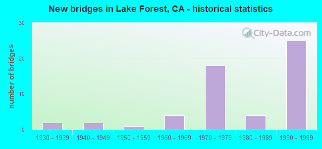
- New bridges - historical statistics
- 21930-1939
- 21940-1949
- 11950-1959
- 41960-1969
- 181970-1979
- 41980-1989
- 251990-1999

- Reconstructed bridges - Historical Statistics
- 41970-1979
- 11980-1989
- 51990-1999
- 12000-2009


- Bridge Condition - Deck
- 59.5%Good
- 37.8%Fair
- 2.7%Poor

- Bridge Condition - Superstructure
- 77.5%Good
- 22.5%Fair

- Bridge Condition - Substructure
- 67.5%Good
- 2.5%Satisfactory
- 30.0%Fair

- Bridge Condition - Channel
- 3.2%Excellent
- 87.1%Very good
- 9.7%Good

- Bridge Condition - Culverts
- 50.0%Good
- 50.0%Satisfactory
Find on map >> Show street view
Structure Number: 55 0541L, Location: 12-ORA-073-R26.77-CMS (Lat: 33.675633, Lng: -117.888250), Route carried "on" structure: State highway 73, Year Built: 1977, Status: Open, Structure Length: 6.16m (20.21ft), Average Daily Traffic: 86,000 (year 2011), Truck Traffic: 1%, Average Future Daily Traffic: 95,500 (year 2038), Design Load: HS 20+Mod, Features Intersected: BRISTOL STREET
Minimum Vertical Clearance: 30+ m (98+ ft), Kilometerpoint: 26.770, Lanes on structure: 5, Lanes under structure: 6, Base Highway Network: Yes (, Subroute: 1), Owner: State Highway Agency, Approaching Roadway Width: 30.2m (99.1ft), Skew: 1 degrees, Material/Design: Prestressed concrete continuous, Design/Construction: Box Beam or Girders - Multiple, Number Of Spans In Main Unit: 2, Length of Maximum Span: 31.7m (104.0ft), Curb-To-Curb Width: 30.2m (99.1ft), Out-to-Out Width: 30.8m (101.0ft)
Condition: Deck: Good, Superstructure: Fair, Substructure: Fair, Operating Rating: 54.1 metric tons, Method Used To Determine Operating Rating: Assigned rating based on Load Factor Design (LFD) reported in metric tons, Inventory Rating: 32.4 metric tons, Method Used To Determine Inventory Rating: Assigned rating based on Load Factor Design (LFD) reported in metric tons, Structural Evaluation: Somewhat better than minimum adequacy, Deck Geometry: Superior to present desirable criteria, Underclear: Equal to present minimum criteria, Approach Roadway Alignment: Equal to present desirable criteria, Designated Inspection Frequency: Every 24 months, Inspection Date: May 2020, Deck Structure Type: Concrete Cast-file-Place
Find on map >> Show street view
Structure Number: 55 0548, Location: 12-ORA-005-19.89-LKFR (Lat: 33.628244, Lng: -117.721042), Route carried "on" structure: County highway M225, Year Built: 1974, Status: Open, Structure Length: 11.73m (38.48ft), Average Daily Traffic: 50,000 (year 2019), Truck Traffic: 3%, Average Future Daily Traffic: 52,123 (year 2038), Design Load: HS 20, Features Intersected: INTERSTATE 5, Facility Carried by Structure: LAKE FOREST DR
Minimum Vertical Clearance: 30+ m (98+ ft), Kilometerpoint: 0.000, Lanes on structure: 6, Lanes under structure: 18, Owner: State Highway Agency, Approaching Roadway Width: 26.8m (87.9ft), Skew: 24 degrees, Material/Design: Prestressed concrete continuous, Design/Construction: Box Beam or Girders - Multiple, Number Of Spans In Main Unit: 2, Length of Maximum Span: 60.0m (196.9ft), Curb or Sidewalk Widths: Left: 0.0m, Right: 1.5m (4.9ft), Curb-To-Curb Width: 26.8m (87.9ft), Out-to-Out Width: 33.2m (108.9ft)
Condition: Deck: Fair, Superstructure: Fair, Substructure: Satisfactory, Operating Rating: 54.1 metric tons, Method Used To Determine Operating Rating: Assigned rating based on Load Factor Design (LFD) reported in metric tons, Inventory Rating: 32.4 metric tons, Method Used To Determine Inventory Rating: Assigned rating based on Load Factor Design (LFD) reported in metric tons, Structural Evaluation: Somewhat better than minimum adequacy, Deck Geometry: Better than present minimum criteria, Underclear: Meets minimum limits, Approach Roadway Alignment: Somewhat better than minimum adequacy, Designated Inspection Frequency: Every 24 months, Inspection Date: July 2021, Deck Structure Type: Concrete Cast-file-Place
Find on map >> Show street view
Structure Number: 55 0700L, Location: 12-ORA-241-18.70-RSM (Lat: 33.645106, Lng: -117.605253), Route carried "on" structure: State highway 241, Year Built: 1995, Year Reconstructed: 2005, Status: Open, Structure Length: 42.67m (139.99ft), Average Daily Traffic: 9,150 (year 2012), Truck Traffic: 6%, Average Future Daily Traffic: 23,000 (year 2040), Design Load: HS 20+Mod, Features Intersected: TRABUCO CREEK
Minimum Vertical Clearance: 30+ m (98+ ft), Kilometerpoint: 18.700, Lanes on structure: 3, Base Highway Network: Yes (Inventory Route: 2, Subroute: 1), Toll: On toll road, Owner: State Highway Agency, Approaching Roadway Width: 25.2m (82.7ft), Material/Design: Prestressed concrete continuous, Design/Construction: Box Beam or Girders - Multiple, Number Of Spans In Main Unit: 8, Length of Maximum Span: 56.4m (185.0ft), Curb-To-Curb Width: 25.2m (82.7ft), Out-to-Out Width: 26.2m (86.0ft)
Condition: Deck: Fair, Superstructure: Fair, Substructure: Fair, Channel: Very good, Operating Rating: 54.1 metric tons, Method Used To Determine Operating Rating: Assigned rating based on Load Factor Design (LFD) reported in metric tons, Inventory Rating: 32.4 metric tons, Method Used To Determine Inventory Rating: Assigned rating based on Load Factor Design (LFD) reported in metric tons, Structural Evaluation: Somewhat better than minimum adequacy, Deck Geometry: Superior to present desirable criteria, Waterway Adequacy: Equal to present desirable criteria, Approach Roadway Alignment: Equal to present desirable criteria, Designated Inspection Frequency: Every 24 months, Inspection Date: November 2020, Deck Structure Type: Concrete Cast-file-Place
Find on map >> Show street view
Structure Number: 55 0705, Location: 12-ORA-241-21.85-LKFR (Lat: 33.667950, Lng: -117.650336), Route carried "on" structure: State highway 241, Year Built: 1995, Year Reconstructed: 2003, Status: Open, Structure Length: 11.89m (39.01ft), Average Daily Traffic: 36,000 (year 2012), Truck Traffic: 8%, Average Future Daily Traffic: 93,800 (year 2040), Design Load: HS 20+Mod, Features Intersected: PORTOLA PARKWAY
Minimum Vertical Clearance: 30+ m (98+ ft), Kilometerpoint: 21.850, Lanes on structure: 5, Lanes under structure: 7, Base Highway Network: Yes (Inventory Route: 2, Subroute: 1), Owner: State Highway Agency, Approaching Roadway Width: 54.3m (178.1ft), Skew: 2 degrees, Material/Design: Prestressed concrete continuous, Design/Construction: Box Beam or Girders - Multiple, Number Of Spans In Main Unit: 3, Length of Maximum Span: 63.1m (207.0ft), Curb-To-Curb Width: 54.3m (178.1ft), Out-to-Out Width: 55.9m (183.4ft)
Condition: Deck: Good, Superstructure: Good, Substructure: Fair, Operating Rating: 54.1 metric tons, Method Used To Determine Operating Rating: Assigned rating based on Load Factor Design (LFD) reported in metric tons, Inventory Rating: 32.4 metric tons, Method Used To Determine Inventory Rating: Assigned rating based on Load Factor Design (LFD) reported in metric tons, Structural Evaluation: Somewhat better than minimum adequacy, Deck Geometry: Superior to present desirable criteria, Underclear: Equal to present minimum criteria, Approach Roadway Alignment: Equal to present desirable criteria, Designated Inspection Frequency: Every 24 months, Inspection Date: November 2020, Deck Structure Type: Concrete Cast-file-Place
Find on map >> Show street view
Structure Number: 55 0706, Location: 12-ORA-241-22.50-LKFR (Lat: 33.671956, Lng: -117.660347), Route carried "on" structure: State highway 241, Year Built: 1993, Year Reconstructed: 2003, Status: Open, Structure Length: 5.24m (17.19ft), Average Daily Traffic: 36,000 (year 2012), Average Future Daily Traffic: 93,800 (year 2040), Design Load: HS 20+Mod, Features Intersected: LAKE FOREST DRIVE
Minimum Vertical Clearance: 30+ m (98+ ft), Kilometerpoint: 22.500, Lanes on structure: 5, Lanes under structure: 6, Base Highway Network: Yes (Inventory Route: 2, Subroute: 1), Toll: On toll road, Owner: State Highway Agency, Approaching Roadway Width: 54.3m (178.1ft), Skew: 1 degrees, Material/Design: Prestressed concrete, Design/Construction: Box Beam or Girders - Multiple, Number Of Spans In Main Unit: 1, Length of Maximum Span: 51.8m (169.9ft), Curb-To-Curb Width: 54.3m (178.1ft), Out-to-Out Width: 55.9m (183.4ft)
Condition: Deck: Good, Superstructure: Good, Substructure: Fair, Operating Rating: 54.1 metric tons, Method Used To Determine Operating Rating: Assigned rating based on Load Factor Design (LFD) reported in metric tons, Inventory Rating: 32.4 metric tons, Method Used To Determine Inventory Rating: Assigned rating based on Load Factor Design (LFD) reported in metric tons, Structural Evaluation: Somewhat better than minimum adequacy, Deck Geometry: Superior to present desirable criteria, Underclear: Meets minimum limits, Approach Roadway Alignment: Equal to present desirable criteria, Designated Inspection Frequency: Every 24 months, Inspection Date: November 2020, Deck Structure Type: Concrete Cast-file-Place
Find on map >> Show street view
Structure Number: 55 0707, Location: 12-ORA-241-22.77-LKFR (Lat: 33.673967, Lng: -117.665239), Route carried "on" structure: State highway 241, Year Built: 1993, Year Reconstructed: 2003, Status: Open, Structure Length: 5.61m (18.41ft), Average Daily Traffic: 43,000 (year 2012), Truck Traffic: 3%, Average Future Daily Traffic: 93,800 (year 2040), Design Load: HS 20+Mod, Features Intersected: BAKE PARKWAY
Minimum Vertical Clearance: 30+ m (98+ ft), Kilometerpoint: 22.770, Lanes on structure: 7, Lanes under structure: 5, Base Highway Network: Yes (Inventory Route: 2, Subroute: 1), Toll: On toll road, Owner: State Highway Agency, Approaching Roadway Width: 61.6m (202.1ft), Skew: 2 degrees, Material/Design: Prestressed concrete, Design/Construction: Box Beam or Girders - Multiple, Number Of Spans In Main Unit: 1, Length of Maximum Span: 55.5m (182.1ft), Curb-To-Curb Width: 61.6m (202.1ft), Out-to-Out Width: 63.2m (207.3ft)
Condition: Deck: Good, Superstructure: Good, Substructure: Fair, Operating Rating: 54.1 metric tons, Method Used To Determine Operating Rating: Assigned rating based on Load Factor Design (LFD) reported in metric tons, Inventory Rating: 32.4 metric tons, Method Used To Determine Inventory Rating: Assigned rating based on Load Factor Design (LFD) reported in metric tons, Structural Evaluation: Somewhat better than minimum adequacy, Deck Geometry: Superior to present desirable criteria, Underclear: Somewhat better than minimum adequacy, Approach Roadway Alignment: Equal to present desirable criteria, Designated Inspection Frequency: Every 24 months, Inspection Date: November 2020, Deck Structure Type: Concrete Cast-file-Place
Find on map >> Show street view
Structure Number: 55 0708, Location: 12-ORA-241-23.46-LKFR (Lat: 33.679664, Lng: -117.673536), Route carried "on" structure: County highway , Year Built: 1993, Status: Open, Structure Length: 6.10m (20.01ft), Average Daily Traffic: 15,000 (year 2012), Truck Traffic: 3%, Average Future Daily Traffic: 16,833 (year 2040), Design Load: HS 20+Mod, Features Intersected: STATE ROUTE 241, Facility Carried by Structure: ALTON PKWY
Minimum Vertical Clearance: 5.31m (17.42ft), Kilometerpoint: 0.000, Lanes on structure: 6, Lanes under structure: 6, Owner: State Highway Agency, Approaching Roadway Width: 41.2m (135.2ft), Material/Design: Prestressed concrete continuous, Design/Construction: Box Beam or Girders - Multiple, Number Of Spans In Main Unit: 2, Length of Maximum Span: 29.9m (98.1ft), Curb or Sidewalk Widths: Left: 2.3m (7.5ft), Right: 2.3m (7.5ft), Curb-To-Curb Width: 41.2m (135.2ft), Out-to-Out Width: 46.4m (152.2ft)
Condition: Deck: Good, Superstructure: Good, Substructure: Fair, Operating Rating: 54.1 metric tons, Method Used To Determine Operating Rating: Assigned rating based on Load Factor Design (LFD) reported in metric tons, Inventory Rating: 32.4 metric tons, Method Used To Determine Inventory Rating: Assigned rating based on Load Factor Design (LFD) reported in metric tons, Structural Evaluation: Somewhat better than minimum adequacy, Deck Geometry: Superior to present desirable criteria, Underclear: Equal to present minimum criteria, Approach Roadway Alignment: Equal to present desirable criteria, Designated Inspection Frequency: Every 24 months, Inspection Date: November 2020, Deck Structure Type: Concrete Cast-file-Place
Find on map >> Show street view
Structure Number: 55 0709K, Location: 12-ORA-241-23.62-LKFR (Lat: 33.681769, Lng: -117.674992), Route carried "on" structure: Ramp State highway 241, Year Built: 1993, Status: Open, Structure Length: 4.94m (16.21ft), Average Daily Traffic: 3,090 (year 2012), Truck Traffic: 3%, Average Future Daily Traffic: 3,468 (year 2040), Design Load: HS 20+Mod, Features Intersected: TOWNE CENTRE DR
Minimum Vertical Clearance: 30+ m (98+ ft), Kilometerpoint: 23.620, Lanes on structure: 1, Lanes under structure: 4, Toll: On toll road, Owner: State Highway Agency, Approaching Roadway Width: 7.3m (24.0ft), Material/Design: Prestressed concrete, Design/Construction: Box Beam or Girders - Multiple, Number Of Spans In Main Unit: 1, Length of Maximum Span: 49.4m (162.1ft), Curb-To-Curb Width: 7.3m (24.0ft), Out-to-Out Width: 8.4m (27.6ft)
Condition: Deck: Good, Superstructure: Good, Substructure: Fair, Operating Rating: 54.1 metric tons, Method Used To Determine Operating Rating: Assigned rating based on Load Factor Design (LFD) reported in metric tons, Inventory Rating: 32.4 metric tons, Method Used To Determine Inventory Rating: Assigned rating based on Load Factor Design (LFD) reported in metric tons, Structural Evaluation: Somewhat better than minimum adequacy, Deck Geometry: Better than present minimum criteria, Underclear: High priority of corrective action, Approach Roadway Alignment: Equal to present desirable criteria, Designated Inspection Frequency: Every 24 months, Inspection Date: November 2020, Deck Structure Type: Concrete Cast-file-Place
Find on map >> Show street view
Structure Number: 55 0709L, Location: 12-ORA-241-23.62-LKFR (Lat: 33.681953, Lng: -117.674711), Route carried "on" structure: State highway 241, Year Built: 1993, Year Reconstructed: 1998, Status: Open, Structure Length: 4.79m (15.72ft), Average Daily Traffic: 21,500 (year 2012), Truck Traffic: 3%, Average Future Daily Traffic: 46,900 (year 2040), Design Load: HS 20+Mod, Features Intersected: TOWNE CENTRE DR
Minimum Vertical Clearance: 30+ m (98+ ft), Kilometerpoint: 23.620, Lanes on structure: 3, Lanes under structure: 4, Base Highway Network: Yes (Inventory Route: 2, Subroute: 1), Toll: On toll road, Owner: State Highway Agency, Approaching Roadway Width: 17.1m (56.1ft), Material/Design: Prestressed concrete, Design/Construction: Box Beam or Girders - Multiple, Number Of Spans In Main Unit: 1, Length of Maximum Span: 47.9m (157.2ft), Curb-To-Curb Width: 17.1m (56.1ft), Out-to-Out Width: 18.1m (59.4ft)
Condition: Deck: Good, Superstructure: Good, Substructure: Fair, Operating Rating: 54.1 metric tons, Method Used To Determine Operating Rating: Assigned rating based on Load Factor Design (LFD) reported in metric tons, Inventory Rating: 32.4 metric tons, Method Used To Determine Inventory Rating: Assigned rating based on Load Factor Design (LFD) reported in metric tons, Structural Evaluation: Somewhat better than minimum adequacy, Deck Geometry: Equal to present minimum criteria, Underclear: High priority of corrective action, Approach Roadway Alignment: Equal to present desirable criteria, Designated Inspection Frequency: Every 24 months, Inspection Date: November 2020, Deck Structure Type: Concrete Cast-file-Place
Find on map >> Show street view
Structure Number: 55 0709R, Location: 12-ORA-241-23.62-LKFR (Lat: 33.682125, Lng: -117.674364), Route carried "on" structure: State highway 241, Year Built: 1993, Year Reconstructed: 1997, Status: Open, Structure Length: 4.79m (15.72ft), Average Daily Traffic: 21,500 (year 2012), Truck Traffic: 3%, Average Future Daily Traffic: 46,900 (year 2040), Design Load: HS 20+Mod, Features Intersected: TOWNE CENTRE DR
Minimum Vertical Clearance: 30+ m (98+ ft), Kilometerpoint: 23.620, Lanes on structure: 3, Lanes under structure: 4, Base Highway Network: Yes (Inventory Route: 2, Subroute: 1), Toll: On toll road, Owner: State Highway Agency, Approaching Roadway Width: 17.1m (56.1ft), Material/Design: Prestressed concrete, Design/Construction: Box Beam or Girders - Multiple, Number Of Spans In Main Unit: 1, Length of Maximum Span: 47.9m (157.2ft), Curb-To-Curb Width: 17.1m (56.1ft), Out-to-Out Width: 18.1m (59.4ft)
Condition: Deck: Good, Superstructure: Good, Substructure: Fair, Operating Rating: 54.1 metric tons, Method Used To Determine Operating Rating: Assigned rating based on Load Factor Design (LFD) reported in metric tons, Inventory Rating: 32.4 metric tons, Method Used To Determine Inventory Rating: Assigned rating based on Load Factor Design (LFD) reported in metric tons, Structural Evaluation: Somewhat better than minimum adequacy, Deck Geometry: Equal to present minimum criteria, Underclear: High priority of corrective action, Approach Roadway Alignment: Equal to present desirable criteria, Designated Inspection Frequency: Every 24 months, Inspection Date: November 2020, Deck Structure Type: Concrete Cast-file-Place
Find on map >> Show street view
Structure Number: 55 0709S, Location: 12-ORA-241-23.62-LKFR (Lat: 33.682178, Lng: -117.674228), Route carried "on" structure: Ramp State highway 241, Year Built: 1993, Status: Open, Structure Length: 4.94m (16.21ft), Average Daily Traffic: 2,610 (year 2012), Truck Traffic: 3%, Average Future Daily Traffic: 2,929 (year 2040), Design Load: HS 20+Mod, Features Intersected: TOWNE CENTRE DR
Minimum Vertical Clearance: 30+ m (98+ ft), Kilometerpoint: 23.620, Lanes on structure: 1, Lanes under structure: 4, Toll: On toll road, Owner: State Highway Agency, Approaching Roadway Width: 7.3m (24.0ft), Material/Design: Prestressed concrete, Design/Construction: Box Beam or Girders - Multiple, Number Of Spans In Main Unit: 1, Length of Maximum Span: 49.4m (162.1ft), Curb-To-Curb Width: 7.3m (24.0ft), Out-to-Out Width: 8.4m (27.6ft)
Condition: Deck: Good, Superstructure: Good, Substructure: Good, Operating Rating: 54.1 metric tons, Method Used To Determine Operating Rating: Assigned rating based on Load Factor Design (LFD) reported in metric tons, Inventory Rating: 32.4 metric tons, Method Used To Determine Inventory Rating: Assigned rating based on Load Factor Design (LFD) reported in metric tons, Structural Evaluation: Better than present minimum criteria, Deck Geometry: Better than present minimum criteria, Underclear: High priority of corrective action, Approach Roadway Alignment: Equal to present desirable criteria, Designated Inspection Frequency: Every 24 months, Inspection Date: November 2020, Deck Structure Type: Concrete Cast-file-Place
Find on map >> Show street view
Structure Number: 55 0712, Location: 12-ORA-241-22.39-LKFR (Lat: 33.671128, Lng: -117.658186), Route carried "on" structure: State highway 241, Year Built: 1993, Status: Open, Structure Length: 2.01m (6.59ft), Average Daily Traffic: 36,000 (year 2012), Average Future Daily Traffic: 93,800 (year 2040), Design Load: HS 20+Mod, Features Intersected: EQUESTRIAN TRAIL
Minimum Vertical Clearance: 30+ m (98+ ft), Kilometerpoint: 22.390, Lanes on structure: 5, Base Highway Network: Yes (Inventory Route: 2, Subroute: 1), Toll: On toll road, Owner: State Highway Agency, Approaching Roadway Width: 57.4m (188.3ft), Skew: 3 degrees, Material/Design: Prestressed concrete, Design/Construction: Box Beam or Girders - Multiple, Number Of Spans In Main Unit: 1, Length of Maximum Span: 20.1m (65.9ft), Curb-To-Curb Width: 57.4m (188.3ft), Out-to-Out Width: 59.0m (193.6ft)
Condition: Deck: Good, Superstructure: Good, Substructure: Fair, Operating Rating: 54.1 metric tons, Method Used To Determine Operating Rating: Assigned rating based on Load Factor Design (LFD) reported in metric tons, Inventory Rating: 32.4 metric tons, Method Used To Determine Inventory Rating: Assigned rating based on Load Factor Design (LFD) reported in metric tons, Structural Evaluation: Somewhat better than minimum adequacy, Deck Geometry: Superior to present desirable criteria, Approach Roadway Alignment: Equal to present desirable criteria, Designated Inspection Frequency: Every 24 months, Inspection Date: November 2020, Deck Structure Type: Concrete Cast-file-Place
Find on map >> Show street view
Structure Number: 55C0049, Location: 0.3 MI S/O MODJESKA RD (Lat: 33.712478, Lng: -117.645111), Route carried "on" structure: County highway , Year Built: 1967, Status: Open, Structure Length: 6.00m (19.69ft), Average Daily Traffic: 8,000 (year 2021), Truck Traffic: 3%, Average Future Daily Traffic: 12,365 (year 2039), Design Load: HS 20, Features Intersected: SANTIAGO CREEK, Facility Carried by Structure: SANTIAGO CANYON RD
Minimum Vertical Clearance: 30+ m (98+ ft), Kilometerpoint: 0.000, Lanes on structure: 2, Base Highway Network: Yes, Owner: County Highway Agency, Approaching Roadway Width: 12.5m (41.0ft), Skew: 1 degrees, Material/Design: Concrete continuous, Design/Construction: Tee Beam, Number Of Spans In Main Unit: 3, Length of Maximum Span: 23.8m (78.1ft), Curb-To-Curb Width: 9.0m (29.5ft), Out-to-Out Width: 10.1m (33.1ft)
Condition: Deck: Good, Superstructure: Good, Substructure: Good, Channel: Very good, Operating Rating: 38.6 metric tons, Method Used To Determine Operating Rating: Load and Resistance Factor Rating (LRFR) rating reported by rating factor(RF) method using HL-93 loadings, Inventory Rating: 29.8 metric tons, Method Used To Determine Inventory Rating: Load and Resistance Factor Rating (LRFR) rating reported by rating factor(RF) method using HL-93 loadings, Structural Evaluation: Better than present minimum criteria, Deck Geometry: High priority of replacement, Waterway Adequacy: Superior to present desirable criteria, Approach Roadway Alignment: Equal to present desirable criteria, Designated Inspection Frequency: Every 24 months, Inspection Date: May 2021, Deck Structure Type: Concrete Cast-file-Place
Find on map >> Show street view
Structure Number: 55C0059, Location: 0.8 MI N/O MODJESKA RD (Lat: 33.728764, Lng: -117.650281), Route carried "on" structure: County highway , Year Built: 1970, Year Reconstructed: 1983, Status: Open, Structure Length: 1.07m (3.51ft), Average Daily Traffic: 8,000 (year 2021), Truck Traffic: 3%, Average Future Daily Traffic: 12,365 (year 2039), Design Load: HS 20, Features Intersected: WILLIAMS CANYON CREEK, Facility Carried by Structure: SANTIAGO CANYON RD
Minimum Vertical Clearance: 30+ m (98+ ft), Kilometerpoint: 0.000, Lanes on structure: 2, Base Highway Network: Yes, Owner: County Highway Agency, Approaching Roadway Width: 15.9m (52.2ft), Material/Design: Concrete, Design/Construction: Slab, Number Of Spans In Main Unit: 1, Length of Maximum Span: 10.1m (33.1ft), Curb-To-Curb Width: 15.9m (52.2ft), Out-to-Out Width: 16.2m (53.1ft)
Condition: Deck: Fair, Superstructure: Fair, Substructure: Good, Channel: Very good, Operating Rating: 53.5 metric tons, Method Used To Determine Operating Rating: Load Factor (LF), Inventory Rating: 32.6 metric tons, Method Used To Determine Inventory Rating: Load Factor (LF), Structural Evaluation: Somewhat better than minimum adequacy, Deck Geometry: Superior to present desirable criteria, Waterway Adequacy: Equal to present desirable criteria, Approach Roadway Alignment: Equal to present desirable criteria, Designated Inspection Frequency: Every 24 months, Inspection Date: May 2021, Deck Structure Type: Concrete Cast-file-Place
Find on map >> Show street view
Structure Number: 55C0063, Location: 1.0 MI. NE/O TRABUCO ROAD (Lat: 33.643978, Lng: -117.666072), Route carried "on" structure: City street , Year Built: 1975, Year Reconstructed: 1983, Status: Open, Structure Length: 4.05m (13.29ft), Average Daily Traffic: 42,000 (year 2012), Truck Traffic: 2%, Average Future Daily Traffic: 67,053 (year 2038), Design Load: HS 20, Features Intersected: ALISO CREEK, Facility Carried by Structure: EL TORO ROAD
Minimum Vertical Clearance: 30+ m (98+ ft), Kilometerpoint: 0.000, Lanes on structure: 5, Base Highway Network: Yes, Owner: City or Municipal Highway Agency, Approaching Roadway Width: 26.9m (88.3ft), Skew: 33 degrees, Material/Design: Concrete continuous, Design/Construction: Tee Beam, Number Of Spans In Main Unit: 3, Length of Maximum Span: 15.8m (51.8ft), Curb or Sidewalk Widths: Left: 1.5m (4.9ft), Right: 1.5m (4.9ft), Curb-To-Curb Width: 26.9m (88.3ft), Out-to-Out Width: 31.7m (104.0ft)
Condition: Deck: Fair, Superstructure: Good, Substructure: Good, Channel: Very good, Operating Rating: 52.8 metric tons, Method Used To Determine Operating Rating: Load and Resistance Factor Rating (LRFR) rating reported by rating factor(RF) method using HL-93 loadings, Inventory Rating: 38.6 metric tons, Method Used To Determine Inventory Rating: Load and Resistance Factor Rating (LRFR) rating reported by rating factor(RF) method using HL-93 loadings, Structural Evaluation: Better than present minimum criteria, Deck Geometry: Superior to present desirable criteria, Waterway Adequacy: Superior to present desirable criteria, Approach Roadway Alignment: Equal to present desirable criteria, Designated Inspection Frequency: Every 24 months, Inspection Date: May 2020, Deck Structure Type: Concrete Cast-file-Place
Find on map >> Show street view
Structure Number: 55C0155, Location: 0.35 MI. S/O TORO ROAD (Lat: 33.624828, Lng: -117.686669), Route carried "on" structure: City street , Year Built: 1974, Status: Open, Structure Length: 2.65m (8.69ft), Average Daily Traffic: 28,281 (year 2020), Truck Traffic: 1%, Average Future Daily Traffic: 42,048 (year 2040), Design Load: HS 20, Features Intersected: ALISO CREEK, Facility Carried by Structure: JERONIMO ROAD
Minimum Vertical Clearance: 30+ m (98+ ft), Kilometerpoint: 0.000, Lanes on structure: 4, Base Highway Network: Yes, Owner: City or Municipal Highway Agency, Approaching Roadway Width: 20.1m (65.9ft), Skew: 1 degrees, Material/Design: Prestressed concrete, Design/Construction: Box Beam or Girders - Multiple, Number Of Spans In Main Unit: 1, Length of Maximum Span: 25.6m (84.0ft), Curb or Sidewalk Widths: Left: 1.5m (4.9ft), Right: 1.5m (4.9ft), Curb-To-Curb Width: 25.3m (83.0ft), Out-to-Out Width: 29.0m (95.1ft)
Condition: Deck: Fair, Superstructure: Fair, Substructure: Good, Channel: Very good, Operating Rating: 52.8 metric tons, Method Used To Determine Operating Rating: Load and Resistance Factor Rating (LRFR) rating reported by rating factor(RF) method using HL-93 loadings, Inventory Rating: 40.8 metric tons, Method Used To Determine Inventory Rating: Load and Resistance Factor Rating (LRFR) rating reported by rating factor(RF) method using HL-93 loadings, Structural Evaluation: Somewhat better than minimum adequacy, Deck Geometry: Superior to present desirable criteria, Waterway Adequacy: Equal to present desirable criteria, Approach Roadway Alignment: Equal to present desirable criteria, Designated Inspection Frequency: Every 24 months, Inspection Date: September 2020, Deck Structure Type: Concrete Cast-file-Place
Find on map >> Show street view
Structure Number: 55C0172, Location: 0.1 MI N/O MODJESKA GR RD (Lat: 33.708656, Lng: -117.636197), Route carried "on" structure: County highway , Year Built: 1935, Status: Open, Structure Length: 1.95m (6.40ft), Average Daily Traffic: 1,000 (year 2021), Truck Traffic: 1%, Average Future Daily Traffic: 1,052 (year 2039), Design Load: H 15, Features Intersected: SANTIAGO CREEK, Facility Carried by Structure: MODJESKA CANYON RD
Minimum Vertical Clearance: 30+ m (98+ ft), Kilometerpoint: 0.000, Lanes on structure: 2, Owner: County Highway Agency, Approaching Roadway Width: 6.1m (20.0ft), Skew: 6 degrees, Material/Design: Steel, Design/Construction: Girder and Floorbeam System, Number Of Spans In Main Unit: 1, Length of Maximum Span: 19.5m (64.0ft), Curb or Sidewalk Widths: Left: 0.7m (2.3ft), Right: 0.7m (2.3ft), Curb-To-Curb Width: 6.1m (20.0ft), Out-to-Out Width: 7.3m (24.0ft)
Condition: Deck: Fair, Superstructure: Good, Substructure: Good, Channel: Very good, Operating Rating: 38.2 metric tons, Method Used To Determine Operating Rating: Load Factor (LF), Inventory Rating: 23.0 metric tons, Method Used To Determine Inventory Rating: Load Factor (LF), Structural Evaluation: Equal to present minimum criteria, Deck Geometry: High priority of corrective action, Waterway Adequacy: Equal to present desirable criteria, Approach Roadway Alignment: Equal to present minimum criteria, Designated Inspection Frequency: Every 24 months, Critical Feature Inspection Frequency: Every 24 months, Inspection Date: May 2021, Critical Feature Inspection Date: May 2020, Deck Structure Type: Concrete Cast-file-Place
Find on map >> Show street view
Structure Number: 55C0173, Location: .4 MI. E/O MODJESKA G RD (Lat: 33.708014, Lng: -117.628869), Route carried "on" structure: County highway , Year Built: 1947, Status: Open, Structure Length: 1.71m (5.61ft), Average Daily Traffic: 1,000 (year 2021), Truck Traffic: 1%, Average Future Daily Traffic: 1,052 (year 2039), Design Load: H 15, Features Intersected: SANTIAGO CREEK, Facility Carried by Structure: MODJESKA CANYON RD
Minimum Vertical Clearance: 30+ m (98+ ft), Kilometerpoint: 0.000, Lanes on structure: 2, Owner: County Highway Agency, Approaching Roadway Width: 7.3m (24.0ft), Material/Design: Steel, Design/Construction: Stringer/Multi-beam, Number Of Spans In Main Unit: 1, Length of Maximum Span: 16.8m (55.1ft), Curb or Sidewalk Widths: Left: 0.9m (3.0ft), Right: 0.5m (1.6ft), Curb-To-Curb Width: 7.3m (24.0ft), Out-to-Out Width: 8.8m (28.9ft)
Condition: Deck: Good, Superstructure: Good, Substructure: Good, Channel: Very good, Operating Rating: 33.0 metric tons, Method Used To Determine Operating Rating: Load Factor (LF), Inventory Rating: 19.8 metric tons, Method Used To Determine Inventory Rating: Load Factor (LF), Structural Evaluation: Somewhat better than minimum adequacy, Deck Geometry: Meets minimum limits, Waterway Adequacy: Equal to present desirable criteria, Approach Roadway Alignment: Equal to present minimum criteria, Designated Inspection Frequency: Every 24 months, Inspection Date: May 2021, Deck Structure Type: Concrete Cast-file-Place
Find on map >> Show street view
Structure Number: 55C0174, Location: 1.6 MI E/O SANTIAGO ROAD (Lat: 33.745647, Lng: -117.650206), Route carried "on" structure: County highway , Year Built: 1935, Status: Open, Structure Length: 1.77m (5.81ft), Average Daily Traffic: 2,000 (year 2021), Truck Traffic: 1%, Average Future Daily Traffic: 4,204 (year 2039), Design Load: H 15, Features Intersected: SILVERADO CANYON CREEK, Facility Carried by Structure: SILVERADO CNYN RD.
Minimum Vertical Clearance: 30+ m (98+ ft), Kilometerpoint: 0.000, Lanes on structure: 2, Owner: County Highway Agency, Approaching Roadway Width: 7.0m (23.0ft), Skew: 3 degrees, Material/Design: Steel, Design/Construction: Girder and Floorbeam System, Number Of Spans In Main Unit: 1, Length of Maximum Span: 17.7m (58.1ft), Curb or Sidewalk Widths: Left: 0.7m (2.3ft), Right: 1.2m (3.9ft), Curb-To-Curb Width: 7.0m (23.0ft), Out-to-Out Width: 9.7m (31.8ft)
Condition: Deck: Fair, Superstructure: Good, Substructure: Good, Channel: Very good, Operating Rating: 37.3 metric tons, Method Used To Determine Operating Rating: Load Factor (LF), Inventory Rating: 24.3 metric tons, Method Used To Determine Inventory Rating: Load Factor (LF), Structural Evaluation: Equal to present minimum criteria, Deck Geometry: High priority of corrective action, Waterway Adequacy: Superior to present desirable criteria, Approach Roadway Alignment: Equal to present minimum criteria, Designated Inspection Frequency: Every 24 months, Critical Feature Inspection Frequency: Every 24 months, Inspection Date: May 2021, Critical Feature Inspection Date: May 2020, Deck Structure Type: Concrete Cast-file-Place
Find on map >> Show street view
Structure Number: 55C0175, Location: 2.2 MI. E/O SANTIAGO ROAD (Lat: 33.748111, Lng: -117.640467), Route carried "on" structure: County highway , Year Built: 1947, Status: Open, Structure Length: 1.57m (5.15ft), Average Daily Traffic: 2,000 (year 2021), Truck Traffic: 1%, Average Future Daily Traffic: 4,204 (year 2039), Design Load: H 15, Features Intersected: LADD CANYON, Facility Carried by Structure: SILVERADO CANYN RD
Minimum Vertical Clearance: 30+ m (98+ ft), Kilometerpoint: 0.000, Lanes on structure: 2, Owner: County Highway Agency, Approaching Roadway Width: 6.7m (22.0ft), Skew: 6 degrees, Material/Design: Steel, Design/Construction: Stringer/Multi-beam, Number Of Spans In Main Unit: 1, Length of Maximum Span: 15.2m (49.9ft), Curb-To-Curb Width: 7.4m (24.3ft), Out-to-Out Width: 8.2m (26.9ft)
Condition: Deck: Good, Superstructure: Good, Substructure: Good, Channel: Good, Operating Rating: 28.8 metric tons, Method Used To Determine Operating Rating: Load and Resistance Factor Rating (LRFR) rating reported by rating factor(RF) method using HL-93 loadings, Inventory Rating: 22.4 metric tons, Method Used To Determine Inventory Rating: Load and Resistance Factor Rating (LRFR) rating reported by rating factor(RF) method using HL-93 loadings, Structural Evaluation: Somewhat better than minimum adequacy, Deck Geometry: Meets minimum limits, Waterway Adequacy: Equal to present desirable criteria, Approach Roadway Alignment: Equal to present minimum criteria, Designated Inspection Frequency: Every 24 months, Inspection Date: May 2021, Deck Structure Type: Concrete Cast-file-Place
Find on map >> Show street view
Structure Number: 55C0176, Location: 0.1 MI. S/O SLVRDO CYN RD (Lat: 33.746669, Lng: -117.637647), Route carried "on" structure: County highway , Year Built: 1970, Year Reconstructed: 1983, Status: Open, Structure Length: 0.91m (2.99ft), Average Daily Traffic: 200 (year 2021), Truck Traffic: 1%, Average Future Daily Traffic: 210 (year 2039), Features Intersected: SILVERADO CANYON CREEK, Facility Carried by Structure: KITTERMAN DRIVE
Minimum Vertical Clearance: 30+ m (98+ ft), Kilometerpoint: 0.000, Lanes on structure: 1, Owner: County Highway Agency, Approaching Roadway Width: 3.8m (12.5ft), Material/Design: Wood or Timber, Design/Construction: Stringer/Multi-beam, Number Of Spans In Main Unit: 1, Length of Maximum Span: 9.1m (29.9ft), Curb-To-Curb Width: 3.8m (12.5ft), Out-to-Out Width: 4.3m (14.1ft)
Condition: Deck: Good, Superstructure: Good, Substructure: Fair, Channel: Very good, Operating Rating: 36.6 metric tons, Method Used To Determine Operating Rating: Allowable Stress (AS), Inventory Rating: 25.3 metric tons, Method Used To Determine Inventory Rating: Allowable Stress (AS), Structural Evaluation: Somewhat better than minimum adequacy, Deck Geometry: High priority of replacement, Waterway Adequacy: Equal to present desirable criteria, Approach Roadway Alignment: Equal to present minimum criteria, Designated Inspection Frequency: Every 24 months, Inspection Date: May 2021, Deck Structure Type: Wood or Timber, Wearing Surface/Protective System: Wearing Surface: Bituminous
Find on map >> Show street view
Structure Number: 55C0181, Location: 3.1 MI E/O SANTIAGO ROAD (Lat: 33.747164, Lng: -117.623203), Route carried "on" structure: County highway , Year Built: 1970, Status: Open, Structure Length: 1.40m (4.59ft), Average Daily Traffic: 2,000 (year 2021), Truck Traffic: 1%, Average Future Daily Traffic: 4,204 (year 2039), Features Intersected: SILVERADO CANYON CREEK, Facility Carried by Structure: SILVERADO CNYN RD.
Minimum Vertical Clearance: 30+ m (98+ ft), Kilometerpoint: 0.000, Lanes on structure: 2, Owner: County Highway Agency, Approaching Roadway Width: 8.2m (26.9ft), Skew: 5 degrees, Material/Design: Concrete, Design/Construction: Slab, Number Of Spans In Main Unit: 1, Length of Maximum Span: 6.1m (20.0ft), Curb-To-Curb Width: 7.3m (24.0ft), Out-to-Out Width: 8.2m (26.9ft)
Condition: Deck: Good, Superstructure: Good, Substructure: Good, Channel: Very good, Operating Rating: 40.5 metric tons, Method Used To Determine Operating Rating: Field evaluation and documented engineering judgment, Inventory Rating: 24.3 metric tons, Method Used To Determine Inventory Rating: Field evaluation and documented engineering judgment, Structural Evaluation: Equal to present minimum criteria, Deck Geometry: Meets minimum limits, Waterway Adequacy: Equal to present desirable criteria, Approach Roadway Alignment: Equal to present desirable criteria, Designated Inspection Frequency: Every 24 months, Inspection Date: July 2021, Deck Structure Type: Concrete Cast-file-Place, Wearing Surface/Protective System: Wearing Surface: Bituminous
Find on map >> Show street view
Structure Number: 55C0182, Location: 3.6 MI. E/O SANTIAGO ROAD (Lat: 33.746731, Lng: -117.618997), Route carried "on" structure: County highway , Year Built: 1970, Status: Open, Structure Length: 1.31m (4.30ft), Average Daily Traffic: 2,000 (year 2021), Truck Traffic: 1%, Average Future Daily Traffic: 4,204 (year 2039), Features Intersected: SILVERADO CANYON CREEK, Facility Carried by Structure: SILVERADO CNYN RD.
Minimum Vertical Clearance: 30+ m (98+ ft), Kilometerpoint: 0.000, Lanes on structure: 2, Owner: County Highway Agency, Approaching Roadway Width: 6.1m (20.0ft), Skew: 5 degrees, Material/Design: Concrete, Design/Construction: Slab, Number Of Spans In Main Unit: 1, Length of Maximum Span: 6.7m (22.0ft), Curb-To-Curb Width: 6.1m (20.0ft), Out-to-Out Width: 6.7m (22.0ft)
Condition: Deck: Good, Superstructure: Good, Substructure: Good, Channel: Very good, Operating Rating: 40.5 metric tons, Method Used To Determine Operating Rating: Field evaluation and documented engineering judgment, Inventory Rating: 24.3 metric tons, Method Used To Determine Inventory Rating: Field evaluation and documented engineering judgment, Structural Evaluation: Equal to present minimum criteria, Deck Geometry: High priority of replacement, Waterway Adequacy: Equal to present desirable criteria, Approach Roadway Alignment: Equal to present minimum criteria, Designated Inspection Frequency: Every 24 months, Inspection Date: July 2021, Deck Structure Type: Concrete Cast-file-Place, Wearing Surface/Protective System: Wearing Surface: Bituminous
Find on map >> Show street view
Structure Number: 55C0185, Location: 50' S/O MODJESKA CYN RD (Lat: 33.709456, Lng: -117.625467), Route carried "on" structure: County highway , Year Built: 1970, Status: Open, Structure Length: 1.10m (3.61ft), Average Daily Traffic: 150 (year 2021), Truck Traffic: 1%, Average Future Daily Traffic: 206 (year 2039), Features Intersected: SANTIAGO CREEK, Facility Carried by Structure: OLIVE HILL ROAD
Minimum Vertical Clearance: 30+ m (98+ ft), Kilometerpoint: 0.000, Lanes on structure: 1, Owner: County Highway Agency, Approaching Roadway Width: 4.9m (16.1ft), Material/Design: Concrete, Design/Construction: Slab, Number Of Spans In Main Unit: 1, Length of Maximum Span: 10.4m (34.1ft), Curb-To-Curb Width: 4.7m (15.4ft), Out-to-Out Width: 4.9m (16.1ft)
Condition: Deck: Good, Superstructure: Good, Substructure: Good, Channel: Very good, Operating Rating: 33.7 metric tons, Method Used To Determine Operating Rating: Field evaluation and documented engineering judgment, Inventory Rating: 20.4 metric tons, Method Used To Determine Inventory Rating: Field evaluation and documented engineering judgment, Structural Evaluation: Somewhat better than minimum adequacy, Deck Geometry: High priority of replacement, Waterway Adequacy: Equal to present desirable criteria, Approach Roadway Alignment: Somewhat better than minimum adequacy, Designated Inspection Frequency: Every 24 months, Inspection Date: May 2021, Deck Structure Type: Concrete Cast-file-Place
Find on map >> Show street view
Structure Number: 55C0188, Location: 200' S/O SILVERADO CYN RD (Lat: 33.747086, Lng: -117.639603), Route carried "on" structure: County highway , Year Built: 1965, Status: Open, Structure Length: 0.79m (2.59ft), Average Daily Traffic: 200 (year 2021), Truck Traffic: 1%, Average Future Daily Traffic: 210 (year 2039), Features Intersected: SILVERADO CANYON CREEK, Facility Carried by Structure: THISA WAY
Minimum Vertical Clearance: 30+ m (98+ ft), Kilometerpoint: 0.000, Lanes on structure: 2, Owner: County Highway Agency, Approaching Roadway Width: 7.4m (24.3ft), Material/Design: Concrete, Design/Construction: Culvert, Number Of Spans In Main Unit: 1, Length of Maximum Span: 7.3m (24.0ft), Curb-To-Curb Width: 7.2m (23.6ft), Out-to-Out Width: 7.3m (24.0ft)
Condition: Channel: Very good, Culverts: Satisfactory, Operating Rating: 40.5 metric tons, Method Used To Determine Operating Rating: Field evaluation and documented engineering judgment, Inventory Rating: 24.3 metric tons, Method Used To Determine Inventory Rating: Field evaluation and documented engineering judgment, Structural Evaluation: Equal to present minimum criteria, Deck Geometry: Meets minimum limits, Waterway Adequacy: Equal to present minimum criteria, Approach Roadway Alignment: Equal to present minimum criteria, Designated Inspection Frequency: Every 24 months, Inspection Date: May 2021, Wearing Surface/Protective System: Wearing Surface: Bituminous
Find on map >> Show street view
Structure Number: 55C0189, Location: 50' N/O SILVERADO CYN RD (Lat: 33.746297, Lng: -117.628608), Route carried "on" structure: County highway , Year Built: 1957, Status: Open, Structure Length: 0.85m (2.79ft), Average Daily Traffic: 100 (year 2021), Truck Traffic: 1%, Average Future Daily Traffic: 210 (year 2039), Design Load: HS 20, Features Intersected: SILVERADO CANYON CREEK, Facility Carried by Structure: SYCAMORE DRIVE
Minimum Vertical Clearance: 30+ m (98+ ft), Kilometerpoint: 0.000, Lanes on structure: 1, Owner: County Highway Agency, Approaching Roadway Width: 3.4m (11.2ft), Material/Design: Prestressed concrete, Design/Construction: Slab, Number Of Spans In Main Unit: 1, Length of Maximum Span: 7.9m (25.9ft), Curb-To-Curb Width: 3.4m (11.2ft), Out-to-Out Width: 3.7m (12.1ft)
Condition: Deck: Good, Superstructure: Good, Substructure: Fair, Channel: Good, Operating Rating: 47.6 metric tons, Method Used To Determine Operating Rating: Load Factor (LF), Inventory Rating: 32.4 metric tons, Method Used To Determine Inventory Rating: Load Factor (LF), Structural Evaluation: Somewhat better than minimum adequacy, Deck Geometry: High priority of corrective action, Waterway Adequacy: Equal to present minimum criteria, Approach Roadway Alignment: Equal to present minimum criteria, Designated Inspection Frequency: Every 24 months, Inspection Date: May 2021, Deck Structure Type: Concrete Precast Panels, Wearing Surface/Protective System: Wearing Surface: Bituminous
Find on map >> Show street view
Structure Number: 55C0213, Location: 0.2 MI SW/O JERONIMO RD (Lat: 33.620397, Lng: -117.687414), Route carried "on" structure: City street , Year Built: 1977, Status: Open, Structure Length: 3.84m (12.60ft), Average Daily Traffic: 42,100 (year 2020), Truck Traffic: 1%, Average Future Daily Traffic: 66,488 (year 2041), Design Load: HS 20+Mod, Features Intersected: SCRRA,BNSF RY,AMTRAK, Facility Carried by Structure: LOS ALISOS BLVD
Minimum Vertical Clearance: 30+ m (98+ ft), Kilometerpoint: 0.000, Lanes on structure: 6, Base Highway Network: Yes, Owner: City or Municipal Highway Agency, Approaching Roadway Width: 26.8m (87.9ft), Skew: 31 degrees, Material/Design: Concrete continuous, Design/Construction: Tee Beam, Number Of Spans In Main Unit: 3, Length of Maximum Span: 15.2m (49.9ft), Curb or Sidewalk Widths: Left: 1.5m (4.9ft), Right: 1.5m (4.9ft), Curb-To-Curb Width: 26.8m (87.9ft), Out-to-Out Width: 31.7m (104.0ft)
Condition: Deck: Poor, Superstructure: Good, Substructure: Good, Operating Rating: 47.3 metric tons, Method Used To Determine Operating Rating: Load and Resistance Factor Rating (LRFR) rating reported by rating factor(RF) method using HL-93 loadings, Inventory Rating: 36.6 metric tons, Method Used To Determine Inventory Rating: Load and Resistance Factor Rating (LRFR) rating reported by rating factor(RF) method using HL-93 loadings, Structural Evaluation: Better than present minimum criteria, Deck Geometry: Better than present minimum criteria, Underclear: Superior to present desirable criteria, Approach Roadway Alignment: Equal to present desirable criteria, Designated Inspection Frequency: Every 24 months, Inspection Date: May 2020, Deck Structure Type: Concrete Cast-file-Place
Find on map >> Show street view
Structure Number: 55C0216L, Location: 0.35 MI. E/O EL TORO ROAD (Lat: 33.633036, Lng: -117.676481), Route carried "on" structure: City street , Year Built: 1975, Status: Open, Structure Length: 6.22m (20.41ft), Average Daily Traffic: 16,500 (year 2011), Truck Traffic: 1%, Average Future Daily Traffic: 25,652 (year 2041), Design Load: HS 20, Features Intersected: ALISO CREEK, Facility Carried by Structure: WB TRABUCO ROAD
Minimum Vertical Clearance: 30+ m (98+ ft), Kilometerpoint: 0.000, Lanes on structure: 2, Base Highway Network: Yes, Owner: City or Municipal Highway Agency, Approaching Roadway Width: 10.4m (34.1ft), Skew: 2 degrees, Material/Design: Concrete continuous, Design/Construction: Box Beam or Girders - Multiple, Number Of Spans In Main Unit: 2, Length of Maximum Span: 30.5m (100.1ft), Curb-To-Curb Width: 12.2m (40.0ft), Out-to-Out Width: 12.8m (42.0ft)
Condition: Deck: Fair, Superstructure: Good, Substructure: Good, Channel: Very good, Operating Rating: 54.1 metric tons, Method Used To Determine Operating Rating: Assigned rating based on Load Factor Design (LFD) reported in metric tons, Inventory Rating: 32.4 metric tons, Method Used To Determine Inventory Rating: Assigned rating based on Load Factor Design (LFD) reported in metric tons, Structural Evaluation: Better than present minimum criteria, Deck Geometry: Better than present minimum criteria, Waterway Adequacy: Equal to present desirable criteria, Approach Roadway Alignment: Better than present minimum criteria, Designated Inspection Frequency: Every 24 months, Inspection Date: September 2020, Deck Structure Type: Concrete Cast-file-Place
Find on map >> Show street view
Structure Number: 55C0216R, Location: 0.35 MI. E/O EL TORO ROAD (Lat: 33.632914, Lng: -117.676597), Route carried "on" structure: City street , Year Built: 1975, Status: Open, Structure Length: 6.22m (20.41ft), Average Daily Traffic: 16,500 (year 2011), Truck Traffic: 2%, Average Future Daily Traffic: 25,652 (year 2041), Design Load: HS 20, Features Intersected: ALISO CREEK, Facility Carried by Structure: EB TRABUCO ROAD
Minimum Vertical Clearance: 30+ m (98+ ft), Kilometerpoint: 0.000, Lanes on structure: 2, Base Highway Network: Yes, Owner: City or Municipal Highway Agency, Approaching Roadway Width: 10.4m (34.1ft), Skew: 2 degrees, Material/Design: Concrete continuous, Design/Construction: Box Beam or Girders - Multiple, Number Of Spans In Main Unit: 2, Length of Maximum Span: 30.5m (100.1ft), Curb-To-Curb Width: 12.2m (40.0ft), Out-to-Out Width: 12.8m (42.0ft)
Condition: Deck: Fair, Superstructure: Good, Substructure: Good, Channel: Excellent, Operating Rating: 54.1 metric tons, Method Used To Determine Operating Rating: Assigned rating based on Load Factor Design (LFD) reported in metric tons, Inventory Rating: 32.4 metric tons, Method Used To Determine Inventory Rating: Assigned rating based on Load Factor Design (LFD) reported in metric tons, Structural Evaluation: Better than present minimum criteria, Deck Geometry: Better than present minimum criteria, Waterway Adequacy: Equal to present desirable criteria, Approach Roadway Alignment: Better than present minimum criteria, Designated Inspection Frequency: Every 24 months, Inspection Date: September 2020, Deck Structure Type: Concrete Cast-file-Place
Find on map >> Show street view
Structure Number: 55C0218, Location: 200' NW/O LOS ALISOS BLVD (Lat: 33.617603, Lng: -117.692953), Route carried "on" structure: City street , Year Built: 1973, Status: Open, Structure Length: 1.55m (5.09ft), Average Daily Traffic: 22,000 (year 2012), Truck Traffic: 2%, Average Future Daily Traffic: 25,945 (year 2037), Design Load: HS 20, Features Intersected: ALISO CREEK, Facility Carried by Structure: MUIRLANDS BLVD.
Minimum Vertical Clearance: 30+ m (98+ ft), Kilometerpoint: 0.000, Lanes on structure: 5, Base Highway Network: Yes, Owner: City or Municipal Highway Agency, Approaching Roadway Width: 19.5m (64.0ft), Skew: 20 degrees, Material/Design: Prestressed concrete, Design/Construction: Slab, Number Of Spans In Main Unit: 1, Length of Maximum Span: 14.6m (47.9ft), Curb or Sidewalk Widths: Left: 1.8m (5.9ft), Right: 1.8m (5.9ft), Curb-To-Curb Width: 19.5m (64.0ft), Out-to-Out Width: 23.8m (78.1ft)
Condition: Deck: Good, Superstructure: Good, Substructure: Good, Channel: Very good, Operating Rating: 54.1 metric tons, Method Used To Determine Operating Rating: Assigned rating based on Load Factor Design (LFD) reported in metric tons, Inventory Rating: 32.4 metric tons, Method Used To Determine Inventory Rating: Assigned rating based on Load Factor Design (LFD) reported in metric tons, Structural Evaluation: Better than present minimum criteria, Deck Geometry: Meets minimum limits, Waterway Adequacy: Superior to present desirable criteria, Approach Roadway Alignment: Equal to present desirable criteria, Designated Inspection Frequency: Every 48 months, Inspection Date: March 2019, Deck Structure Type: Concrete Precast Panels, Wearing Surface/Protective System: Wearing Surface: Bituminous
Find on map >> Show street view
Structure Number: 55C0219, Location: 0.29 MI. S/O MUIRLAND BL. (Lat: 33.613369, Lng: -117.695497), Route carried "on" structure: City street , Year Built: 1973, Status: Open, Structure Length: 2.74m (8.99ft), Average Daily Traffic: 45,250 (year 2020), Truck Traffic: 1%, Average Future Daily Traffic: 67,276 (year 2040), Design Load: HS 20, Features Intersected: ALISO CREEK, Facility Carried by Structure: LOS ALISOS BLVD
Minimum Vertical Clearance: 30+ m (98+ ft), Kilometerpoint: 0.000, Lanes on structure: 4, Owner: City or Municipal Highway Agency, Approaching Roadway Width: 19.5m (64.0ft), Skew: 5 degrees, Material/Design: Concrete, Design/Construction: Box Beam or Girders - Multiple, Number Of Spans In Main Unit: 1, Length of Maximum Span: 25.9m (85.0ft), Curb or Sidewalk Widths: Left: 1.5m (4.9ft), Right: 1.5m (4.9ft), Curb-To-Curb Width: 23.2m (76.1ft), Out-to-Out Width: 26.8m (87.9ft)
Condition: Deck: Fair, Superstructure: Fair, Substructure: Good, Channel: Very good, Operating Rating: 54.1 metric tons, Method Used To Determine Operating Rating: Field evaluation and documented engineering judgment, Inventory Rating: 32.4 metric tons, Method Used To Determine Inventory Rating: Field evaluation and documented engineering judgment, Structural Evaluation: Somewhat better than minimum adequacy, Deck Geometry: Superior to present desirable criteria, Waterway Adequacy: Equal to present desirable criteria, Approach Roadway Alignment: Equal to present desirable criteria, Designated Inspection Frequency: Every 24 months, Inspection Date: September 2020, Deck Structure Type: Concrete Cast-file-Place
Find on map >> Show street view
Structure Number: 55C0222, Location: 0.2 MI. NW/O LAKE FOREST (Lat: 33.649519, Lng: -117.688342), Route carried "on" structure: City street , Year Built: 1969, Year Reconstructed: 1978, Status: Open, Structure Length: 2.32m (7.61ft), Average Daily Traffic: 29,000 (year 2015), Truck Traffic: 1%, Average Future Daily Traffic: 60,564 (year 2038), Design Load: HS 20, Features Intersected: SERRANO CREEK, Facility Carried by Structure: TRABUCO ROAD
Minimum Vertical Clearance: 30+ m (98+ ft), Kilometerpoint: 0.000, Lanes on structure: 6, Base Highway Network: Yes, Owner: City or Municipal Highway Agency, Approaching Roadway Width: 29.1m (95.5ft), Skew: 3 degrees, Material/Design: Prestressed concrete, Design/Construction: Box Beam or Girders - Multiple, Number Of Spans In Main Unit: 1, Length of Maximum Span: 22.6m (74.1ft), Curb or Sidewalk Widths: Left: 2.4m (7.9ft), Right: 3.0m (9.8ft), Curb-To-Curb Width: 29.1m (95.5ft), Out-to-Out Width: 36.8m (120.7ft)
Condition: Deck: Good, Superstructure: Good, Substructure: Good, Channel: Very good, Operating Rating: 29.8 metric tons, Method Used To Determine Operating Rating: Field evaluation and documented engineering judgment, Inventory Rating: 17.8 metric tons, Method Used To Determine Inventory Rating: Field evaluation and documented engineering judgment, Structural Evaluation: Meets minimum limits, Deck Geometry: Superior to present desirable criteria, Waterway Adequacy: Superior to present desirable criteria, Approach Roadway Alignment: Equal to present desirable criteria, Designated Inspection Frequency: Every 24 months, Inspection Date: May 2020, Deck Structure Type: Concrete Precast Panels, Wearing Surface/Protective System: Wearing Surface: Bituminous
Find on map >> Show street view
Structure Number: 55C0223, Location: 100' NE/O TOLEDO WAY (Lat: 33.650317, Lng: -117.706683), Route carried "on" structure: City street , Year Built: 1975, Year Reconstructed: 1980, Status: Open, Structure Length: 1.22m (4.00ft), Average Daily Traffic: 47,000 (year 2012), Truck Traffic: 1%, Average Future Daily Traffic: 98,155 (year 2038), Features Intersected: SERRANO CREEK, Facility Carried by Structure: BAKE PARKWAY
Minimum Vertical Clearance: 30+ m (98+ ft), Kilometerpoint: 0.000, Lanes on structure: 7, Base Highway Network: Yes, Owner: City or Municipal Highway Agency, Approaching Roadway Width: 29.2m (95.8ft), Skew: 31 degrees, Material/Design: Concrete, Design/Construction: Culvert, Number Of Spans In Main Unit: 3, Length of Maximum Span: 3.7m (12.1ft), Curb or Sidewalk Widths: Left: 2.7m (8.9ft), Right: 1.5m (4.9ft), Curb-To-Curb Width: 26.2m (86.0ft), Out-to-Out Width: 39.6m (129.9ft)
Condition: Channel: Very good, Culverts: Satisfactory, Operating Rating: 54.1 metric tons, Method Used To Determine Operating Rating: Field evaluation and documented engineering judgment, Inventory Rating: 32.4 metric tons, Method Used To Determine Inventory Rating: Field evaluation and documented engineering judgment, Structural Evaluation: Equal to present minimum criteria, Deck Geometry: Meets minimum limits, Waterway Adequacy: Superior to present desirable criteria, Approach Roadway Alignment: Equal to present desirable criteria, Designated Inspection Frequency: Every 48 months, Inspection Date: May 2020
Find on map >> Show street view
Structure Number: 55C048, Location: 0.2 MI SE BARRANCA PKWY (Lat: 33.677869, Lng: -117.802717), Route carried "on" structure: City street , Year Built: 1981, Status: Open, Structure Length: 4.78m (15.68ft), Average Daily Traffic: 5,100 (year 2018), Truck Traffic: 7%, Average Future Daily Traffic: 6,500 (year 2040), Design Load: HS 20, Features Intersected: SAN DIEGO CREEK CHANNEL, Facility Carried by Structure: LAKE ROAD
Minimum Vertical Clearance: 30+ m (98+ ft), Kilometerpoint: 0.000, Lanes on structure: 2, Owner: City or Municipal Highway Agency, Approaching Roadway Width: 15.8m (51.8ft), Material/Design: Concrete continuous, Design/Construction: Box Beam or Girders - Multiple, Number Of Spans In Main Unit: 2, Length of Maximum Span: 23.6m (77.4ft), Curb or Sidewalk Widths: Left: 1.5m (4.9ft), Right: 1.5m (4.9ft), Curb-To-Curb Width: 14.5m (47.6ft), Out-to-Out Width: 18.3m (60.0ft)
Condition: Deck: Good, Superstructure: Good, Substructure: Good, Channel: Very good, Operating Rating: 99.8 metric tons, Method Used To Determine Operating Rating: Load Factor (LF), Inventory Rating: 62.5 metric tons, Method Used To Determine Inventory Rating: Load Factor (LF), Structural Evaluation: Better than present minimum criteria, Deck Geometry: Superior to present desirable criteria, Waterway Adequacy: Superior to present desirable criteria, Approach Roadway Alignment: Equal to present desirable criteria, Designated Inspection Frequency: Every 48 months, Inspection Date: November 2020, Deck Structure Type: Concrete Cast-file-Place
Find on map >> Show street view
Structure Number: 55C0489, Location: 200' SE/O EL TORO ROAD (Lat: 33.639333, Lng: -117.669964), Route carried "on" structure: City street , Year Built: 1980, Status: Open, Structure Length: 1.58m (5.18ft), Average Daily Traffic: 1,000 (year 2020), Truck Traffic: 1%, Average Future Daily Traffic: 2,102 (year 2040), Features Intersected: ALISO CREEK, Facility Carried by Structure: CREEKSIDE DRIVE
Minimum Vertical Clearance: 30+ m (98+ ft), Kilometerpoint: 0.000, Lanes on structure: 2, Owner: City or Municipal Highway Agency, Approaching Roadway Width: 11.8m (38.7ft), Skew: 30 degrees, Material/Design: Concrete, Design/Construction: Culvert, Number Of Spans In Main Unit: 4, Length of Maximum Span: 3.7m (12.1ft), Curb or Sidewalk Widths: Left: 1.4m (4.6ft), Right: 1.4m (4.6ft), Curb-To-Curb Width: 11.8m (38.7ft), Out-to-Out Width: 15.8m (51.8ft)
Condition: Channel: Very good, Culverts: Satisfactory, Operating Rating: 54.1 metric tons, Method Used To Determine Operating Rating: Field evaluation and documented engineering judgment, Inventory Rating: 32.4 metric tons, Method Used To Determine Inventory Rating: Field evaluation and documented engineering judgment, Structural Evaluation: Equal to present minimum criteria, Deck Geometry: Better than present minimum criteria, Waterway Adequacy: Equal to present desirable criteria, Approach Roadway Alignment: Equal to present desirable criteria, Designated Inspection Frequency: Every 48 months, Inspection Date: May 2020
Find on map >> Show street view
Structure Number: 55C0593, Location: 0.5 M NW NEWPORT COAST DR (Lat: 33.587461, Lng: -117.855747), Route carried "on" structure: City street , Year Built: 1991, Status: Open, Structure Length: 0.73m (2.40ft), Average Daily Traffic: 35,000 (year 2020), Truck Traffic: 3%, Average Future Daily Traffic: 42,275 (year 2040), Features Intersected: GOLF COURSE ACCESS, Facility Carried by Structure: ROUTE 1 PCH
Minimum Vertical Clearance: 30+ m (98+ ft), Kilometerpoint: 0.000, Lanes on structure: 8, Base Highway Network: Yes, Owner: City or Municipal Highway Agency, Approaching Roadway Width: 34.1m (111.9ft), Material/Design: Steel, Design/Construction: Arch - Deck, Number Of Spans In Main Unit: 1, Length of Maximum Span: 7.3m (24.0ft), Curb-To-Curb Width: 34.1m (111.9ft), Out-to-Out Width: 48.0m (157.5ft)
Condition: Superstructure: Good, Substructure: Good, Operating Rating: 54.1 metric tons, Method Used To Determine Operating Rating: Field evaluation and documented engineering judgment, Inventory Rating: 32.4 metric tons, Method Used To Determine Inventory Rating: Field evaluation and documented engineering judgment, Structural Evaluation: Better than present minimum criteria, Deck Geometry: Equal to present minimum criteria, Approach Roadway Alignment: Equal to present desirable criteria, Designated Inspection Frequency: Every 24 months, Inspection Date: August 2020
Find on map >> Show street view
Structure Number: 55C0595L, Location: 0.3 MI. W/O LAKE FOREST (Lat: 33.662639, Lng: -117.673175), Route carried "on" structure: City street , Year Built: 1987, Status: Open, Structure Length: 2.32m (7.61ft), Average Daily Traffic: 6,000 (year 2020), Truck Traffic: 35%, Average Future Daily Traffic: 8,224 (year 2040), Design Load: HS 20+Mod, Features Intersected: SERRANO CREEK, Facility Carried by Structure: W/B DIMENSION DR.
Minimum Vertical Clearance: 30+ m (98+ ft), Kilometerpoint: 0.000, Lanes on structure: 2, Owner: City or Municipal Highway Agency, Approaching Roadway Width: 10.7m (35.1ft), Skew: 2 degrees, Material/Design: Prestressed concrete, Design/Construction: Stringer/Multi-beam, Number Of Spans In Main Unit: 1, Length of Maximum Span: 22.3m (73.2ft), Curb or Sidewalk Widths: Left: 0.0m, Right: 1.5m (4.9ft), Curb-To-Curb Width: 10.7m (35.1ft), Out-to-Out Width: 14.6m (47.9ft)
Condition: Deck: Fair, Superstructure: Good, Substructure: Good, Channel: Very good, Operating Rating: 54.1 metric tons, Method Used To Determine Operating Rating: Assigned rating based on Load Factor Design (LFD) reported in metric tons, Inventory Rating: 32.4 metric tons, Method Used To Determine Inventory Rating: Assigned rating based on Load Factor Design (LFD) reported in metric tons, Structural Evaluation: Better than present minimum criteria, Deck Geometry: Somewhat better than minimum adequacy, Waterway Adequacy: Equal to present desirable criteria, Approach Roadway Alignment: Equal to present desirable criteria, Designated Inspection Frequency: Every 24 months, Inspection Date: June 2020, Deck Structure Type: Concrete Cast-file-Place
Find on map >> Show street view
Structure Number: 55C0595R, Location: 0.3 MI. W/O LAKE FOREST (Lat: 33.662556, Lng: -117.673331), Route carried "on" structure: City street , Year Built: 1987, Status: Open, Structure Length: 2.32m (7.61ft), Average Daily Traffic: 6,080 (year 2020), Truck Traffic: 35%, Average Future Daily Traffic: 8,224 (year 2040), Design Load: HS 20+Mod, Features Intersected: SERRANO CREEK, Facility Carried by Structure: E/B DIMENSION DR.
Minimum Vertical Clearance: 30+ m (98+ ft), Kilometerpoint: 0.000, Lanes on structure: 2, Owner: City or Municipal Highway Agency, Approaching Roadway Width: 10.7m (35.1ft), Skew: 9 degrees, Material/Design: Prestressed concrete, Design/Construction: Stringer/Multi-beam, Number Of Spans In Main Unit: 1, Length of Maximum Span: 22.3m (73.2ft), Curb or Sidewalk Widths: Left: 1.5m (4.9ft), Right: 0.0m, Curb-To-Curb Width: 10.7m (35.1ft), Out-to-Out Width: 14.6m (47.9ft)
Condition: Deck: Fair, Superstructure: Good, Substructure: Good, Channel: Very good, Operating Rating: 54.1 metric tons, Method Used To Determine Operating Rating: Assigned rating based on Load Factor Design (LFD) reported in metric tons, Inventory Rating: 32.4 metric tons, Method Used To Determine Inventory Rating: Assigned rating based on Load Factor Design (LFD) reported in metric tons, Structural Evaluation: Better than present minimum criteria, Deck Geometry: Somewhat better than minimum adequacy, Waterway Adequacy: Equal to present desirable criteria, Approach Roadway Alignment: Equal to present desirable criteria, Designated Inspection Frequency: Every 24 months, Inspection Date: May 2020, Deck Structure Type: Concrete Cast-file-Place
Find on map >> Show street view
Structure Number: 55C0597, Location: 0.3 MI. SE/O LAKE FOREST (Lat: 33.672192, Lng: -117.653019), Route carried "on" structure: City street , Year Built: 1991, Status: Open, Structure Length: 2.80m (9.19ft), Average Daily Traffic: 35,000 (year 2020), Truck Traffic: 25%, Average Future Daily Traffic: 42,009 (year 2041), Features Intersected: SERRANO CREEK, Facility Carried by Structure: PORTOLA PARKWAY
Minimum Vertical Clearance: 30+ m (98+ ft), Kilometerpoint: 0.000, Lanes on structure: 8, Base Highway Network: Yes, Owner: City or Municipal Highway Agency, Approaching Roadway Width: 32.5m (106.6ft), Skew: 30 degrees, Material/Design: Prestressed concrete, Design/Construction: Box Beam or Girders - Multiple, Number Of Spans In Main Unit: 1, Length of Maximum Span: 27.1m (88.9ft), Curb or Sidewalk Widths: Left: 1.5m (4.9ft), Right: 1.5m (4.9ft), Curb-To-Curb Width: 32.5m (106.6ft), Out-to-Out Width: 37.8m (124.0ft)
Condition: Deck: Fair, Superstructure: Fair, Substructure: Good, Channel: Good, Operating Rating: 54.1 metric tons, Method Used To Determine Operating Rating: Field evaluation and documented engineering judgment, Inventory Rating: 32.4 metric tons, Method Used To Determine Inventory Rating: Field evaluation and documented engineering judgment, Structural Evaluation: Somewhat better than minimum adequacy, Deck Geometry: Somewhat better than minimum adequacy, Waterway Adequacy: Equal to present desirable criteria, Approach Roadway Alignment: Equal to present desirable criteria, Designated Inspection Frequency: Every 24 months, Inspection Date: September 2020, Deck Structure Type: Concrete Cast-file-Place
Find on map >> Show street view
Structure Number: 55C0598, Location: 0.11 MI. S/O ROUTE 241 (Lat: 33.669778, Lng: -117.660928), Route carried "on" structure: City street , Year Built: 1991, Status: Open, Structure Length: 1.07m (3.51ft), Average Daily Traffic: 8,415 (year 2011), Truck Traffic: 1%, Average Future Daily Traffic: 12,614 (year 2038), Features Intersected: SERRANO CREEK, Facility Carried by Structure: LAKE FOREST DRIVE
Minimum Vertical Clearance: 30+ m (98+ ft), Kilometerpoint: 0.000, Lanes on structure: 5, Base Highway Network: Yes, Owner: City or Municipal Highway Agency, Approaching Roadway Width: 24.1m (79.1ft), Skew: 34 degrees, Material/Design: Concrete, Design/Construction: Culvert, Number Of Spans In Main Unit: 2, Length of Maximum Span: 3.7m (12.1ft), Curb or Sidewalk Widths: Left: 1.2m (3.9ft), Right: 2.4m (7.9ft), Curb-To-Curb Width: 24.1m (79.1ft), Out-to-Out Width: 37.2m (122.0ft)
Condition: Channel: Very good, Culverts: Good, Operating Rating: 54.1 metric tons, Method Used To Determine Operating Rating: Field evaluation and documented engineering judgment, Inventory Rating: 32.4 metric tons, Method Used To Determine Inventory Rating: Field evaluation and documented engineering judgment, Structural Evaluation: Better than present minimum criteria, Deck Geometry: Superior to present desirable criteria, Waterway Adequacy: Equal to present desirable criteria, Approach Roadway Alignment: Equal to present desirable criteria, Designated Inspection Frequency: Every 48 months, Inspection Date: May 2020