Bridge Statistics for Lake City, Florida (FL)
Condition, Traffic, Stress, Structural Evaluation, Project Costs
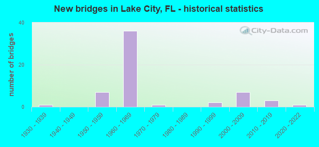
- New bridges - historical statistics
- 11930-1939
- 71950-1959
- 361960-1969
- 11970-1979
- 21990-1999
- 72000-2009
- 32010-2019
- 12020-2022

- Reconstructed bridges - Historical Statistics
- 11940-1949
- 01950-1959
- 01960-1969
- 01970-1979
- 21980-1989
- 121990-1999
- 42000-2009


- Bridge Condition - Deck
- 4.3%Very good
- 87.0%Good
- 8.7%Satisfactory

- Bridge Condition - Superstructure
- 8.7%Very good
- 73.9%Good
- 17.4%Satisfactory

- Bridge Condition - Substructure
- 8.7%Very good
- 82.6%Good
- 4.3%Satisfactory
- 4.3%Fair

- Bridge Condition - Channel
- 3.3%Excellent
- 10.0%Very good
- 63.3%Good
- 23.3%Satisfactory

- Bridge Condition - Culverts
- 4.8%Very good
- 42.9%Good
- 52.4%Satisfactory
Find on map >> Show street view
Structure Number: 290003, Location: 2.5 MI. S. OF LAKE CITY (Lat: 30.127381, Lng: -82.623742), Route carried "on" structure: US 41, Year Built: 1932, Year Reconstructed: 1946, Status: Open, Structure Length: 0.98m (3.22ft), Average Daily Traffic: 5,900 (year 2020), Truck Traffic: 9%, Average Future Daily Traffic: 10,236 (year 2042), Design Load: H 15, Features Intersected: CLAY HOLE CREEK
Minimum Vertical Clearance: 30+ m (98+ ft), Kilometerpoint: 31.033, Lanes on structure: 2, Base Highway Network: Yes, Owner: State Highway Agency, Approaching Roadway Width: 9.8m (32.2ft), Material/Design: Concrete, Design/Construction: Slab, Number Of Spans In Main Unit: 2, Length of Maximum Span: 4.9m (16.1ft), Curb-To-Curb Width: 8.5m (27.9ft), Out-to-Out Width: 9.5m (31.2ft)
Condition: Deck: Good, Superstructure: Good, Substructure: Satisfactory, Channel: Good, Operating Rating: 42.6 metric tons, Method Used To Determine Operating Rating: Load Factor (LF), Inventory Rating: 25.4 metric tons, Method Used To Determine Inventory Rating: Load Factor (LF), Structural Evaluation: Equal to present minimum criteria, Deck Geometry: High priority of replacement, Waterway Adequacy: Equal to present desirable criteria, Approach Roadway Alignment: Equal to present desirable criteria, Length Of Structure Improvement: 0.98m (3.22ft), Designated Inspection Frequency: Every 24 months, Inspection Date: October 2021, Bridge Improvement Cost: $43,000, Roadway Improvement Cost: $4,000, Total Project Cost: $65,000, Deck Structure Type: Concrete Cast-file-Place, Wearing Surface/Protective System: Wearing Surface: Bituminous
Find on map >> Show street view
Structure Number: 290008, Location: 0.5 MI EAST OF US 441 (Lat: 30.210889, Lng: -82.630472), Route carried "on" structure: County highway 250, Year Built: 1953, Status: Open, Structure Length: 0.73m (2.40ft), Average Daily Traffic: 800 (year 2021), Truck Traffic: 3%, Average Future Daily Traffic: 1,388 (year 2042), Design Load: HS 20, Features Intersected: FALLING CREEK, Facility Carried by Structure: GUM SWAMP ROAD
Minimum Vertical Clearance: 30+ m (98+ ft), Kilometerpoint: 0.721, Lanes on structure: 2, Owner: County Highway Agency, Approaching Roadway Width: 6.1m (20.0ft), Skew: 3 degrees, Material/Design: Concrete, Design/Construction: Culvert, Number Of Spans In Main Unit: 2, Length of Maximum Span: 3.8m (12.5ft)
Condition: Channel: Satisfactory, Culverts: Satisfactory, Operating Rating: 60.1 metric tons, Method Used To Determine Operating Rating: Load Factor (LF), Inventory Rating: 36.1 metric tons, Method Used To Determine Inventory Rating: Load Factor (LF), Structural Evaluation: Equal to present minimum criteria, Waterway Adequacy: Equal to present desirable criteria, Approach Roadway Alignment: Better than present minimum criteria, Designated Inspection Frequency: Every 24 months, Inspection Date: October 2021
Find on map >> Show street view
Structure Number: 29001, Location: 0.2 MI SOUTH OF CR 242A (Lat: 30.116250, Lng: -82.634194), Route carried "on" structure: County highway 131, Year Built: 1960, Year Reconstructed: 2005, Status: Open, Structure Length: 0.73m (2.40ft), Average Daily Traffic: 950 (year 2021), Truck Traffic: 3%, Average Future Daily Traffic: 1,648 (year 2042), Design Load: HS 20, Features Intersected: CLAY HOLE CREEK
Minimum Vertical Clearance: 30+ m (98+ ft), Kilometerpoint: 20.709, Lanes on structure: 2, Owner: County Highway Agency, Approaching Roadway Width: 7.6m (24.9ft), Skew: 3 degrees, Material/Design: Concrete, Design/Construction: Culvert, Number Of Spans In Main Unit: 2, Length of Maximum Span: 3.5m (11.5ft)
Condition: Channel: Good, Culverts: Satisfactory, Operating Rating: 56.9 metric tons, Method Used To Determine Operating Rating: Load Factor (LF), Inventory Rating: 34.1 metric tons, Method Used To Determine Inventory Rating: Load Factor (LF), Structural Evaluation: Equal to present minimum criteria, Waterway Adequacy: Equal to present desirable criteria, Approach Roadway Alignment: Equal to present desirable criteria, Designated Inspection Frequency: Every 24 months, Inspection Date: October 2021
Find on map >> Show street view
Structure Number: 290011, Location: 0.2 MI EAST OF CR 131 (Lat: 30.119194, Lng: -82.632194), Route carried "on" structure: County highway 242, Year Built: 1961, Status: Open, Structure Length: 0.69m (2.26ft), Average Daily Traffic: 2,000 (year 2021), Truck Traffic: 10%, Average Future Daily Traffic: 3,470 (year 2042), Design Load: HS 20, Features Intersected: CLAY HOLE CREEK
Minimum Vertical Clearance: 30+ m (98+ ft), Kilometerpoint: 16.402, Lanes on structure: 2, Owner: County Highway Agency, Approaching Roadway Width: 6.4m (21.0ft), Skew: 2 degrees, Material/Design: Concrete, Design/Construction: Culvert, Number Of Spans In Main Unit: 2, Length of Maximum Span: 3.5m (11.5ft)
Condition: Channel: Satisfactory, Culverts: Satisfactory, Operating Rating: 67.3 metric tons, Method Used To Determine Operating Rating: Load Factor (LF), Inventory Rating: 40.4 metric tons, Method Used To Determine Inventory Rating: Load Factor (LF), Structural Evaluation: Equal to present minimum criteria, Waterway Adequacy: Equal to present desirable criteria, Approach Roadway Alignment: Equal to present desirable criteria, Designated Inspection Frequency: Every 24 months, Inspection Date: October 2021
Find on map >> Show street view
Structure Number: 290026, Location: 0.6 MI. S. OF I-75 (Lat: 30.111564, Lng: -82.659158), Route carried "on" structure: State highway 47, Year Built: 1950, Year Reconstructed: 2007, Status: Open, Structure Length: 0.94m (3.08ft), Average Daily Traffic: 12,500 (year 2020), Truck Traffic: 6%, Average Future Daily Traffic: 21,688 (year 2042), Design Load: HS 20, Features Intersected: CLAY HOLE CREEK
Minimum Vertical Clearance: 30+ m (98+ ft), Kilometerpoint: 29.527, Lanes on structure: 3, Base Highway Network: Yes, Owner: State Highway Agency, Approaching Roadway Width: 14.8m (48.6ft), Material/Design: Concrete, Design/Construction: Culvert, Number Of Spans In Main Unit: 3, Length of Maximum Span: 3.0m (9.8ft)
Condition: Channel: Good, Culverts: Good, Operating Rating: 47.0 metric tons, Method Used To Determine Operating Rating: Load Factor (LF), Inventory Rating: 28.1 metric tons, Method Used To Determine Inventory Rating: Load Factor (LF), Structural Evaluation: Better than present minimum criteria, Waterway Adequacy: Equal to present desirable criteria, Approach Roadway Alignment: Equal to present desirable criteria, Designated Inspection Frequency: Every 24 months, Inspection Date: December 2021
Find on map >> Show street view
Structure Number: 290031, Location: US-41/ WASHINGTON ST. (Lat: 30.194722, Lng: -82.639444), Route carried "on" structure: US 41, Year Built: 1958, Status: Open, Structure Length: 2.99m (9.81ft), Average Daily Traffic: 11,600 (year 2020), Truck Traffic: 13%, Average Future Daily Traffic: 20,126 (year 2042), Design Load: HS 20, Features Intersected: WASHINGTON ST.
Minimum Vertical Clearance: 30+ m (98+ ft), Kilometerpoint: 0.584, Lanes on structure: 4, Lanes under structure: 2, Base Highway Network: Yes, Owner: State Highway Agency, Approaching Roadway Width: 16.6m (54.5ft), Skew: 20 degrees, Material/Design: Concrete, Design/Construction: Slab, Number Of Spans In Main Unit: 3, Length of Maximum Span: 10.1m (33.1ft), Curb or Sidewalk Widths: Left: 1.4m (4.6ft), Right: 1.4m (4.6ft), Curb-To-Curb Width: 16.6m (54.5ft), Out-to-Out Width: 21.1m (69.2ft)
Condition: Deck: Good, Superstructure: Good, Substructure: Good, Operating Rating: 65.9 metric tons, Method Used To Determine Operating Rating: Load Factor (LF), Inventory Rating: 39.6 metric tons, Method Used To Determine Inventory Rating: Load Factor (LF), Structural Evaluation: Better than present minimum criteria, Deck Geometry: Somewhat better than minimum adequacy, Underclear: High priority of corrective action, Approach Roadway Alignment: Equal to present desirable criteria, Length Of Structure Improvement: 2.99m (9.81ft), Designated Inspection Frequency: Every 24 months, Inspection Date: November 2021, Bridge Improvement Cost: $264,000, Roadway Improvement Cost: $26,000, Total Project Cost: $395,000, Deck Structure Type: Concrete Cast-file-Place
Find on map >> Show street view
Structure Number: 290032, Location: US-41/NW WILSON ST.&CSXRR (Lat: 30.196667, Lng: -82.639444), Route carried "on" structure: US 41, Year Built: 1958, Status: Open, Structure Length: 15.88m (52.10ft), Average Daily Traffic: 11,600 (year 2020), Truck Traffic: 13%, Average Future Daily Traffic: 20,126 (year 2042), Design Load: H 20, Features Intersected: NW WILSON ST. & CSXRR
Minimum Vertical Clearance: 30+ m (98+ ft), Kilometerpoint: 0.731, Lanes on structure: 4, Lanes under structure: 4, Base Highway Network: Yes, Owner: State Highway Agency, Approaching Roadway Width: 15.6m (51.2ft), Skew: 20 degrees, Material/Design: Steel, Design/Construction: Stringer/Multi-beam, Number Of Spans In Main Unit: 10, Length of Maximum Span: 26.2m (86.0ft), Curb or Sidewalk Widths: Left: 1.5m (4.9ft), Right: 1.5m (4.9ft), Curb-To-Curb Width: 15.6m (51.2ft), Out-to-Out Width: 21.1m (69.2ft)
Condition: Deck: Satisfactory, Superstructure: Satisfactory, Substructure: Good, Operating Rating: 73.3 metric tons, Method Used To Determine Operating Rating: Load Factor (LF), Inventory Rating: 44.0 metric tons, Method Used To Determine Inventory Rating: Load Factor (LF), Structural Evaluation: Equal to present minimum criteria, Deck Geometry: Meets minimum limits, Underclear: Equal to present minimum criteria, Approach Roadway Alignment: Equal to present desirable criteria, Designated Inspection Frequency: Every 24 months, Inspection Date: January 2021, Deck Structure Type: Concrete Cast-file-Place
Find on map >> Show street view
Structure Number: 290033, Location: 0.1 MI. N. SANTA FE RIVER (Lat: 29.855833, Lng: -82.608611), Route carried "on" structure: US 41, Year Built: 1960, Year Reconstructed: 2002, Status: Open, Structure Length: 0.98m (3.22ft), Average Daily Traffic: 4,500 (year 2020), Truck Traffic: 11%, Average Future Daily Traffic: 7,808 (year 2042), Design Load: H 15, Features Intersected: COLUMBIA CREEK
Minimum Vertical Clearance: 30+ m (98+ ft), Kilometerpoint: 0.253, Lanes on structure: 2, Base Highway Network: Yes, Owner: State Highway Agency, Approaching Roadway Width: 9.9m (32.5ft), Material/Design: Concrete, Design/Construction: Culvert, Number Of Spans In Main Unit: 3, Length of Maximum Span: 2.9m (9.5ft)
Condition: Channel: Good, Culverts: Satisfactory, Operating Rating: 47.1 metric tons, Method Used To Determine Operating Rating: Load Factor (LF), Inventory Rating: 28.1 metric tons, Method Used To Determine Inventory Rating: Load Factor (LF), Structural Evaluation: Equal to present minimum criteria, Waterway Adequacy: Equal to present desirable criteria, Approach Roadway Alignment: Equal to present desirable criteria, Designated Inspection Frequency: Every 24 months, Inspection Date: April 2020
Find on map >> Show street view
Structure Number: 290034, Location: SR-247 / I-75 (Lat: 30.164950, Lng: -82.680858), Route carried "on" structure: State highway 247, Year Built: 1962, Status: Open, Structure Length: 7.19m (23.59ft), Average Daily Traffic: 8,200 (year 2020), Truck Traffic: 4%, Average Future Daily Traffic: 14,227 (year 2042), Design Load: HS 20, Features Intersected: I-75 (SR-93)
Minimum Vertical Clearance: 30+ m (98+ ft), Kilometerpoint: 16.140, Lanes on structure: 2, Lanes under structure: 6, Owner: State Highway Agency, Approaching Roadway Width: 9.7m (31.8ft), Skew: 2 degrees, Material/Design: Prestressed concrete, Design/Construction: Stringer/Multi-beam, Number Of Spans In Main Unit: 4, Length of Maximum Span: 22.9m (75.1ft), Curb-To-Curb Width: 8.5m (27.9ft), Out-to-Out Width: 10.4m (34.1ft)
Condition: Deck: Good, Superstructure: Good, Substructure: Good, Operating Rating: 42.0 metric tons, Method Used To Determine Operating Rating: Load Factor (LF), Inventory Rating: 36.0 metric tons, Method Used To Determine Inventory Rating: Load Factor (LF), Structural Evaluation: Better than present minimum criteria, Deck Geometry: Meets minimum limits, Underclear: High priority of corrective action, Approach Roadway Alignment: Equal to present desirable criteria, Designated Inspection Frequency: Every 24 months, Inspection Date: Febuary 2022, Deck Structure Type: Concrete Cast-file-Place
Find on map >> Show street view
Structure Number: 290035, Location: I-75 NB OVER CR-341 (Lat: 30.146389, Lng: -82.671389), Route carried "on" structure: Interstate 75, Year Built: 1962, Year Reconstructed: 1997, Status: Open, Structure Length: 6.25m (20.51ft), Average Daily Traffic: 23,250 (year 2020), Truck Traffic: 33%, Average Future Daily Traffic: 40,339 (year 2042), Features Intersected: CR-341
Minimum Vertical Clearance: 30+ m (98+ ft), Kilometerpoint: 27.243, Lanes on structure: 3, Lanes under structure: 2, Base Highway Network: Yes, Owner: State Highway Agency, Approaching Roadway Width: 17.5m (57.4ft), Skew: 3 degrees, Material/Design: Prestressed concrete, Design/Construction: Stringer/Multi-beam, Number Of Spans In Main Unit: 4, Length of Maximum Span: 17.4m (57.1ft), Curb-To-Curb Width: 17.0m (55.8ft), Out-to-Out Width: 18.0m (59.1ft)
Condition: Deck: Good, Superstructure: Good, Substructure: Good, Operating Rating: 46.7 metric tons, Method Used To Determine Operating Rating: Load Factor (LF), Inventory Rating: 28.0 metric tons, Method Used To Determine Inventory Rating: Load Factor (LF), Structural Evaluation: Better than present minimum criteria, Deck Geometry: Equal to present minimum criteria, Underclear: Somewhat better than minimum adequacy, Approach Roadway Alignment: Equal to present desirable criteria, Designated Inspection Frequency: Every 24 months, Inspection Date: October 2021, Deck Structure Type: Concrete Cast-file-Place
Find on map >> Show street view
Structure Number: 290039, Location: I-75 NB OVER SR-47 (Lat: 30.117703, Lng: -82.655706), Route carried "on" structure: Interstate 75, Year Built: 1962, Year Reconstructed: 1997, Status: Open, Structure Length: 9.17m (30.09ft), Average Daily Traffic: 21,500 (year 2020), Truck Traffic: 33%, Average Future Daily Traffic: 37,302 (year 2042), Features Intersected: SR-47
Minimum Vertical Clearance: 30+ m (98+ ft), Kilometerpoint: 23.706, Lanes on structure: 3, Lanes under structure: 4, Base Highway Network: Yes, Owner: State Highway Agency, Approaching Roadway Width: 17.2m (56.4ft), Skew: 3 degrees, Material/Design: Prestressed concrete, Design/Construction: Stringer/Multi-beam, Number Of Spans In Main Unit: 6, Length of Maximum Span: 16.8m (55.1ft), Curb-To-Curb Width: 17.0m (55.8ft), Out-to-Out Width: 17.9m (58.7ft)
Condition: Deck: Good, Superstructure: Good, Substructure: Good, Channel: Good, Operating Rating: 53.0 metric tons, Method Used To Determine Operating Rating: Load Factor (LF), Inventory Rating: 31.8 metric tons, Method Used To Determine Inventory Rating: Load Factor (LF), Structural Evaluation: Better than present minimum criteria, Deck Geometry: Equal to present minimum criteria, Underclear: High priority of corrective action, Waterway Adequacy: Equal to present desirable criteria, Approach Roadway Alignment: Equal to present desirable criteria, Designated Inspection Frequency: Every 24 months, Inspection Date: October 2021, Deck Structure Type: Concrete Cast-file-Place
Find on map >> Show street view
Structure Number: 290047, Location: SR-47 @ CR-242 ALT. (Lat: 30.115564, Lng: -82.657153), Route carried "on" structure: Alternate State highway 47, Year Built: 1961, Year Reconstructed: 2007, Status: Open, Structure Length: 1.01m (3.31ft), Average Daily Traffic: 11,600 (year 2020), Truck Traffic: 6%, Average Future Daily Traffic: 20,126 (year 2042), Design Load: HS 20, Features Intersected: CANNON CREEK
Minimum Vertical Clearance: 30+ m (98+ ft), Kilometerpoint: 30.064, Lanes on structure: 2, Owner: State Highway Agency, Approaching Roadway Width: 6.9m (22.6ft), Skew: 2 degrees, Material/Design: Concrete, Design/Construction: Culvert, Number Of Spans In Main Unit: 3, Length of Maximum Span: 3.0m (9.8ft)
Condition: Channel: Good, Culverts: Good, Operating Rating: 45.1 metric tons, Method Used To Determine Operating Rating: Load Factor (LF), Inventory Rating: 26.8 metric tons, Method Used To Determine Inventory Rating: Load Factor (LF), Structural Evaluation: Equal to present minimum criteria, Waterway Adequacy: Equal to present desirable criteria, Approach Roadway Alignment: Better than present minimum criteria, Designated Inspection Frequency: Every 24 months, Inspection Date: June 2021
Find on map >> Show street view
Structure Number: 290048, Location: 1.5 MI NORTH OF CR 252 (Lat: 30.155250, Lng: -82.609889), Route carried "on" structure: County highway 133, Year Built: 1966, Status: Open, Structure Length: 0.95m (3.12ft), Average Daily Traffic: 26,000 (year 2021), Truck Traffic: 4%, Average Future Daily Traffic: 45,110 (year 2042), Design Load: HS 20, Features Intersected: PRICE CREEK, Facility Carried by Structure: SE COUNTRY CLUB RD
Minimum Vertical Clearance: 30+ m (98+ ft), Kilometerpoint: 7.490, Lanes on structure: 2, Owner: County Highway Agency, Approaching Roadway Width: 7.3m (24.0ft), Material/Design: Concrete, Design/Construction: Culvert, Number Of Spans In Main Unit: 3, Length of Maximum Span: 3.3m (10.8ft)
Condition: Channel: Satisfactory, Culverts: Good, Operating Rating: 52.1 metric tons, Method Used To Determine Operating Rating: Load Factor (LF), Inventory Rating: 31.2 metric tons, Method Used To Determine Inventory Rating: Load Factor (LF), Structural Evaluation: Better than present minimum criteria, Waterway Adequacy: Equal to present desirable criteria, Approach Roadway Alignment: Equal to present desirable criteria, Designated Inspection Frequency: Every 24 months, Inspection Date: November 2021
Find on map >> Show street view
Structure Number: 290055, Location: 1.9 MI. N OF US-90 (Lat: 30.204939, Lng: -82.701269), Route carried "on" structure: Interstate 75, Year Built: 1962, Year Reconstructed: 1995, Status: Open, Structure Length: 5.39m (17.68ft), Average Daily Traffic: 20,832 (year 2020), Truck Traffic: 34%, Average Future Daily Traffic: 36,143 (year 2042), Features Intersected: NC RR
Minimum Vertical Clearance: 30+ m (98+ ft), Kilometerpoint: 34.329, Lanes on structure: 3, Base Highway Network: Yes, Owner: State Highway Agency, Approaching Roadway Width: 17.5m (57.4ft), Skew: 4 degrees, Material/Design: Prestressed concrete, Design/Construction: Stringer/Multi-beam, Number Of Spans In Main Unit: 3, Length of Maximum Span: 18.0m (59.1ft), Curb-To-Curb Width: 17.0m (55.8ft), Out-to-Out Width: 17.9m (58.7ft)
Condition: Deck: Good, Superstructure: Good, Substructure: Good, Operating Rating: 60.5 metric tons, Method Used To Determine Operating Rating: Load Factor (LF), Inventory Rating: 36.3 metric tons, Method Used To Determine Inventory Rating: Load Factor (LF), Structural Evaluation: Better than present minimum criteria, Deck Geometry: Equal to present minimum criteria, Underclear: Somewhat better than minimum adequacy, Approach Roadway Alignment: Equal to present desirable criteria, Designated Inspection Frequency: Every 24 months, Inspection Date: October 2021, Deck Structure Type: Concrete Cast-file-Place
Find on map >> Show street view
Structure Number: 290058, Location: 0.5 MI. S. OF SR-47 (Lat: 30.111667, Lng: -82.652222), Route carried "on" structure: Interstate 75, Year Built: 1962, Status: Open, Structure Length: 1.34m (4.40ft), Average Daily Traffic: 43,000 (year 2020), Truck Traffic: 33%, Average Future Daily Traffic: 74,605 (year 2042), Design Load: HS 20+Mod, Features Intersected: CLAY HOLE CREEK
Minimum Vertical Clearance: 30+ m (98+ ft), Kilometerpoint: 22.980, Lanes on structure: 6, Base Highway Network: Yes, Owner: State Highway Agency, Approaching Roadway Width: 18.3m (60.0ft), Skew: 13 degrees, Material/Design: Concrete, Design/Construction: Culvert, Number Of Spans In Main Unit: 3, Length of Maximum Span: 3.7m (12.1ft)
Condition: Channel: Satisfactory, Culverts: Satisfactory, Structural Evaluation: Equal to present minimum criteria, Waterway Adequacy: Equal to present desirable criteria, Approach Roadway Alignment: Equal to present desirable criteria, Designated Inspection Frequency: Every 24 months, Inspection Date: March 2021
Find on map >> Show street view
Structure Number: 290059, Location: I-75 SB OVER SR-47 (Lat: 30.117592, Lng: -82.655936), Route carried "on" structure: Interstate 75, Year Built: 1962, Year Reconstructed: 1997, Status: Open, Structure Length: 9.17m (30.09ft), Average Daily Traffic: 21,500 (year 2020), Truck Traffic: 33%, Average Future Daily Traffic: 37,302 (year 2042), Features Intersected: SR-47
Minimum Vertical Clearance: 30+ m (98+ ft), Kilometerpoint: 23.690, Lanes on structure: 3, Lanes under structure: 4, Base Highway Network: Yes, Owner: State Highway Agency, Approaching Roadway Width: 17.2m (56.4ft), Skew: 3 degrees, Material/Design: Prestressed concrete, Design/Construction: Stringer/Multi-beam, Number Of Spans In Main Unit: 6, Length of Maximum Span: 16.8m (55.1ft), Curb-To-Curb Width: 17.0m (55.8ft), Out-to-Out Width: 17.9m (58.7ft)
Condition: Deck: Good, Superstructure: Good, Substructure: Good, Channel: Good, Operating Rating: 53.0 metric tons, Method Used To Determine Operating Rating: Load Factor (LF), Inventory Rating: 31.8 metric tons, Method Used To Determine Inventory Rating: Load Factor (LF), Structural Evaluation: Better than present minimum criteria, Deck Geometry: Equal to present minimum criteria, Underclear: High priority of corrective action, Waterway Adequacy: Superior to present desirable criteria, Approach Roadway Alignment: Equal to present desirable criteria, Designated Inspection Frequency: Every 24 months, Inspection Date: October 2021, Deck Structure Type: Concrete Cast-file-Place
Find on map >> Show street view
Structure Number: 29006, Location: I-75 SB OVER CR-341 (Lat: 30.146342, Lng: -82.671600), Route carried "on" structure: Interstate 75, Year Built: 1962, Year Reconstructed: 1997, Status: Open, Structure Length: 6.25m (20.51ft), Average Daily Traffic: 23,250 (year 2020), Truck Traffic: 33%, Average Future Daily Traffic: 40,339 (year 2042), Features Intersected: CR-341
Minimum Vertical Clearance: 30+ m (98+ ft), Kilometerpoint: 27.227, Lanes on structure: 3, Lanes under structure: 2, Base Highway Network: Yes, Owner: State Highway Agency, Approaching Roadway Width: 17.5m (57.4ft), Skew: 3 degrees, Material/Design: Prestressed concrete, Design/Construction: Stringer/Multi-beam, Number Of Spans In Main Unit: 4, Length of Maximum Span: 17.4m (57.1ft), Curb-To-Curb Width: 17.0m (55.8ft), Out-to-Out Width: 18.1m (59.4ft)
Condition: Deck: Good, Superstructure: Good, Substructure: Good, Operating Rating: 46.7 metric tons, Method Used To Determine Operating Rating: Load Factor (LF), Inventory Rating: 28.0 metric tons, Method Used To Determine Inventory Rating: Load Factor (LF), Structural Evaluation: Better than present minimum criteria, Deck Geometry: Equal to present minimum criteria, Underclear: Somewhat better than minimum adequacy, Approach Roadway Alignment: Equal to present desirable criteria, Designated Inspection Frequency: Every 24 months, Inspection Date: October 2021, Deck Structure Type: Concrete Cast-file-Place
Find on map >> Show street view
Structure Number: 290061, Location: I-75 SB OVER US-90 (Lat: 30.179942, Lng: -82.688769), Route carried "on" structure: Interstate 75, Year Built: 1962, Year Reconstructed: 1995, Status: Open, Structure Length: 5.36m (17.59ft), Average Daily Traffic: 23,250 (year 2020), Truck Traffic: 33%, Average Future Daily Traffic: 40,339 (year 2042), Features Intersected: US-90 (SR-10)
Minimum Vertical Clearance: 30+ m (98+ ft), Kilometerpoint: 31.307, Lanes on structure: 3, Lanes under structure: 4, Base Highway Network: Yes, Owner: State Highway Agency, Approaching Roadway Width: 16.8m (55.1ft), Skew: 1 degrees, Material/Design: Prestressed concrete, Design/Construction: Stringer/Multi-beam, Number Of Spans In Main Unit: 4, Length of Maximum Span: 14.6m (47.9ft), Curb-To-Curb Width: 17.1m (56.1ft), Out-to-Out Width: 17.9m (58.7ft)
Condition: Deck: Good, Superstructure: Good, Substructure: Good, Operating Rating: 55.4 metric tons, Method Used To Determine Operating Rating: Load Factor (LF), Inventory Rating: 36.2 metric tons, Method Used To Determine Inventory Rating: Load Factor (LF), Structural Evaluation: Better than present minimum criteria, Deck Geometry: Equal to present minimum criteria, Underclear: Meets minimum limits, Approach Roadway Alignment: Equal to present desirable criteria, Designated Inspection Frequency: Every 24 months, Inspection Date: October 2021, Total Project Cost: $250,000, Deck Structure Type: Concrete Cast-file-Place
Find on map >> Show street view
Structure Number: 290062, Location: 1.9 MI. N OF US-90 (Lat: 30.204994, Lng: -82.701567), Route carried "on" structure: Interstate 75, Year Built: 1962, Year Reconstructed: 1995, Status: Open, Structure Length: 5.39m (17.68ft), Average Daily Traffic: 20,832 (year 2020), Truck Traffic: 34%, Average Future Daily Traffic: 36,143 (year 2042), Features Intersected: NC RR
Minimum Vertical Clearance: 30+ m (98+ ft), Kilometerpoint: 34.347, Lanes on structure: 3, Base Highway Network: Yes, Owner: State Highway Agency, Approaching Roadway Width: 16.8m (55.1ft), Skew: 4 degrees, Material/Design: Prestressed concrete, Design/Construction: Stringer/Multi-beam, Number Of Spans In Main Unit: 3, Length of Maximum Span: 18.0m (59.1ft), Curb-To-Curb Width: 17.0m (55.8ft), Out-to-Out Width: 17.9m (58.7ft)
Condition: Deck: Good, Superstructure: Good, Substructure: Good, Operating Rating: 60.5 metric tons, Method Used To Determine Operating Rating: Load Factor (LF), Inventory Rating: 36.3 metric tons, Method Used To Determine Inventory Rating: Load Factor (LF), Structural Evaluation: Better than present minimum criteria, Deck Geometry: Equal to present minimum criteria, Underclear: Somewhat better than minimum adequacy, Approach Roadway Alignment: Equal to present desirable criteria, Designated Inspection Frequency: Every 24 months, Inspection Date: October 2021, Deck Structure Type: Concrete Cast-file-Place
Find on map >> Show street view
Structure Number: 290063, Location: 3.2 Mi. N OF US-90 (Lat: 30.221561, Lng: -82.712725), Route carried "on" structure: County highway , Year Built: 1962, Status: Open, Structure Length: 9.08m (29.79ft), Average Daily Traffic: 1,311 (year 2021), Truck Traffic: 2%, Average Future Daily Traffic: 2,275 (year 2042), Design Load: H 20, Features Intersected: I-75 SR-93, Facility Carried by Structure: NASH ROAD
Minimum Vertical Clearance: 30+ m (98+ ft), Kilometerpoint: 4.043, Lanes on structure: 2, Lanes under structure: 6, Owner: State Highway Agency, Approaching Roadway Width: 8.9m (29.2ft), Skew: 4 degrees, Material/Design: Prestressed concrete, Design/Construction: Stringer/Multi-beam, Number Of Spans In Main Unit: 4, Length of Maximum Span: 29.3m (96.1ft), Curb or Sidewalk Widths: Left: 0.6m (2.0ft), Right: 0.6m (2.0ft), Curb-To-Curb Width: 7.3m (24.0ft), Out-to-Out Width: 9.2m (30.2ft)
Condition: Deck: Good, Superstructure: Good, Substructure: Good, Operating Rating: 57.2 metric tons, Method Used To Determine Operating Rating: Load Factor (LF), Inventory Rating: 47.9 metric tons, Method Used To Determine Inventory Rating: Load Factor (LF), Structural Evaluation: Better than present minimum criteria, Deck Geometry: Meets minimum limits, Underclear: High priority of corrective action, Approach Roadway Alignment: Equal to present desirable criteria, Designated Inspection Frequency: Every 24 months, Inspection Date: September 2021, Deck Structure Type: Concrete Cast-file-Place
Find on map >> Show street view
Structure Number: 290064, Location: I-75 NB OVER US-90 (Lat: 30.180000, Lng: -82.688611), Route carried "on" structure: Interstate 75, Year Built: 1962, Year Reconstructed: 1995, Status: Open, Structure Length: 5.36m (17.59ft), Average Daily Traffic: 23,250 (year 2020), Truck Traffic: 33%, Average Future Daily Traffic: 40,339 (year 2042), Features Intersected: US-90 (SR-10)
Minimum Vertical Clearance: 30+ m (98+ ft), Kilometerpoint: 31.302, Lanes on structure: 3, Lanes under structure: 5, Base Highway Network: Yes, Owner: State Highway Agency, Approaching Roadway Width: 17.6m (57.7ft), Skew: 1 degrees, Material/Design: Prestressed concrete, Design/Construction: Stringer/Multi-beam, Number Of Spans In Main Unit: 4, Length of Maximum Span: 14.6m (47.9ft), Curb-To-Curb Width: 17.1m (56.1ft), Out-to-Out Width: 17.9m (58.7ft)
Condition: Deck: Good, Superstructure: Good, Substructure: Good, Operating Rating: 55.4 metric tons, Method Used To Determine Operating Rating: Load Factor (LF), Inventory Rating: 36.2 metric tons, Method Used To Determine Inventory Rating: Load Factor (LF), Structural Evaluation: Better than present minimum criteria, Deck Geometry: Equal to present minimum criteria, Underclear: Meets minimum limits, Approach Roadway Alignment: Equal to present desirable criteria, Designated Inspection Frequency: Every 24 months, Inspection Date: October 2021, Total Project Cost: $250,000, Deck Structure Type: Concrete Cast-file-Place
Find on map >> Show street view
Structure Number: 290071, Location: I-10 WB OVER US-441 (Lat: 30.241781, Lng: -82.638475), Route carried "on" structure: Interstate 10, Year Built: 1962, Year Reconstructed: 1989, Status: Open, Structure Length: 4.75m (15.58ft), Average Daily Traffic: 10,719 (year 2020), Truck Traffic: 33%, Average Future Daily Traffic: 18,597 (year 2042), Design Load: HS 20+Mod, Features Intersected: US-441 SR-47
Minimum Vertical Clearance: 30+ m (98+ ft), Kilometerpoint: 15.627, Lanes on structure: 2, Lanes under structure: 3, Base Highway Network: Yes, Owner: State Highway Agency, Approaching Roadway Width: 11.7m (38.4ft), Material/Design: Prestressed concrete, Design/Construction: Stringer/Multi-beam, Number Of Spans In Main Unit: 3, Length of Maximum Span: 25.9m (85.0ft), Curb-To-Curb Width: 12.1m (39.7ft), Out-to-Out Width: 13.1m (43.0ft)
Condition: Deck: Satisfactory, Superstructure: Satisfactory, Substructure: Good, Operating Rating: 46.3 metric tons, Method Used To Determine Operating Rating: Load Factor (LF), Inventory Rating: 27.2 metric tons, Method Used To Determine Inventory Rating: Load Factor (LF), Structural Evaluation: Equal to present minimum criteria, Deck Geometry: Equal to present minimum criteria, Underclear: Meets minimum limits, Approach Roadway Alignment: Equal to present desirable criteria, Designated Inspection Frequency: Every 24 months, Inspection Date: October 2021, Deck Structure Type: Concrete Cast-file-Place
Find on map >> Show street view
Structure Number: 290072, Location: 0.7 MI. E. OF US-441 (Lat: 30.241667, Lng: -82.627028), Route carried "on" structure: Interstate 10, Year Built: 1964, Year Reconstructed: 1996, Status: Open, Structure Length: 0.94m (3.08ft), Average Daily Traffic: 21,119 (year 2020), Truck Traffic: 31%, Average Future Daily Traffic: 36,641 (year 2042), Design Load: HS 20+Mod, Features Intersected: FALLING CREEK
Minimum Vertical Clearance: 30+ m (98+ ft), Kilometerpoint: 16.758, Lanes on structure: 4, Base Highway Network: Yes, Owner: State Highway Agency, Approaching Roadway Width: 11.8m (38.7ft), Skew: 20 degrees, Material/Design: Concrete, Design/Construction: Culvert, Number Of Spans In Main Unit: 3, Length of Maximum Span: 3.0m (9.8ft)
Condition: Channel: Good, Culverts: Satisfactory, Operating Rating: 54.9 metric tons, Method Used To Determine Operating Rating: Load Factor (LF), Inventory Rating: 32.9 metric tons, Method Used To Determine Inventory Rating: Load Factor (LF), Structural Evaluation: Equal to present minimum criteria, Waterway Adequacy: Better than present minimum criteria, Approach Roadway Alignment: Equal to present desirable criteria, Designated Inspection Frequency: Every 24 months, Inspection Date: Febuary 2021
Find on map >> Show street view
Structure Number: 290073, Location: FOREST RD. 236 / I-10 (Lat: 30.243611, Lng: -82.570556), Route carried "on" structure: Federal lands road 236, Year Built: 1962, Year Reconstructed: 2014, Status: Open, Structure Length: 6.61m (21.69ft), Average Daily Traffic: 150 (year 2020), Average Future Daily Traffic: 260 (year 2042), Design Load: H 20, Features Intersected: I-10 (SR-8)
Minimum Vertical Clearance: 30+ m (98+ ft), Kilometerpoint: 1.098, Lanes on structure: 2, Lanes under structure: 4, Owner: State Highway Agency, Approaching Roadway Width: 7.3m (24.0ft), Skew: 1 degrees, Material/Design: Prestressed concrete, Design/Construction: Stringer/Multi-beam, Number Of Spans In Main Unit: 4, Length of Maximum Span: 21.3m (69.9ft), Curb or Sidewalk Widths: Left: 0.5m (1.6ft), Right: 0.5m (1.6ft), Curb-To-Curb Width: 7.3m (24.0ft), Out-to-Out Width: 8.9m (29.2ft)
Condition: Deck: Good, Superstructure: Good, Substructure: Good, Operating Rating: 42.5 metric tons, Method Used To Determine Operating Rating: Load Factor (LF), Inventory Rating: 33.7 metric tons, Method Used To Determine Inventory Rating: Load Factor (LF), Structural Evaluation: Better than present minimum criteria, Deck Geometry: Somewhat better than minimum adequacy, Underclear: High priority of corrective action, Approach Roadway Alignment: Equal to present minimum criteria, Designated Inspection Frequency: Every 24 months, Inspection Date: January 2022, Deck Structure Type: Concrete Cast-file-Place
Find on map >> Show street view
Structure Number: 290074, Location: 4.3 MI. E. OF US-441 (Lat: 30.244444, Lng: -82.567222), Route carried "on" structure: Interstate 10, Year Built: 1963, Year Reconstructed: 1996, Status: Open, Structure Length: 0.76m (2.49ft), Average Daily Traffic: 21,119 (year 2020), Truck Traffic: 31%, Average Future Daily Traffic: 36,641 (year 2042), Design Load: HS 20+Mod, Features Intersected: FALLING CREEK
Minimum Vertical Clearance: 30+ m (98+ ft), Kilometerpoint: 22.534, Lanes on structure: 4, Base Highway Network: Yes, Owner: State Highway Agency, Approaching Roadway Width: 11.9m (39.0ft), Skew: 20 degrees, Material/Design: Concrete, Design/Construction: Culvert, Number Of Spans In Main Unit: 2, Length of Maximum Span: 3.7m (12.1ft)
Condition: Channel: Good, Culverts: Satisfactory, Operating Rating: 54.6 metric tons, Method Used To Determine Operating Rating: Load Factor (LF), Inventory Rating: 32.7 metric tons, Method Used To Determine Inventory Rating: Load Factor (LF), Structural Evaluation: Equal to present minimum criteria, Approach Roadway Alignment: Equal to present desirable criteria, Designated Inspection Frequency: Every 24 months, Underwater Inspection Frequency: Every 24 months, Inspection Date: Febuary 2021, Underwater Inspection Date: Febuary 2021
Find on map >> Show street view
Structure Number: 290075, Location: 4.5 MI. E. OF US-441 (Lat: 30.245000, Lng: -82.563889), Route carried "on" structure: Interstate 10, Year Built: 1964, Year Reconstructed: 1996, Status: Open, Structure Length: 1.13m (3.71ft), Average Daily Traffic: 21,119 (year 2020), Truck Traffic: 31%, Average Future Daily Traffic: 36,641 (year 2042), Design Load: HS 20+Mod, Features Intersected: FALLING CREEK
Minimum Vertical Clearance: 30+ m (98+ ft), Kilometerpoint: 22.853, Lanes on structure: 4, Base Highway Network: Yes, Owner: State Highway Agency, Approaching Roadway Width: 11.9m (39.0ft), Skew: 20 degrees, Material/Design: Concrete, Design/Construction: Culvert, Number Of Spans In Main Unit: 3, Length of Maximum Span: 3.7m (12.1ft)
Condition: Channel: Good, Culverts: Satisfactory, Operating Rating: 58.1 metric tons, Method Used To Determine Operating Rating: Load Factor (LF), Inventory Rating: 34.8 metric tons, Method Used To Determine Inventory Rating: Load Factor (LF), Structural Evaluation: Equal to present minimum criteria, Waterway Adequacy: Equal to present desirable criteria, Approach Roadway Alignment: Equal to present desirable criteria, Designated Inspection Frequency: Every 24 months, Underwater Inspection Frequency: Every 24 months, Inspection Date: Febuary 2021, Underwater Inspection Date: Febuary 2021
Find on map >> Show street view
Structure Number: 29008, Location: I-10 EB OVER US-441 (Lat: 30.241522, Lng: -82.638458), Route carried "on" structure: Interstate 10, Year Built: 1962, Year Reconstructed: 1989, Status: Open, Structure Length: 4.75m (15.58ft), Average Daily Traffic: 10,719 (year 2020), Truck Traffic: 33%, Average Future Daily Traffic: 18,597 (year 2042), Design Load: HS 20+Mod, Features Intersected: US-441 SR-47
Minimum Vertical Clearance: 30+ m (98+ ft), Kilometerpoint: 15.627, Lanes on structure: 2, Lanes under structure: 3, Base Highway Network: Yes, Owner: State Highway Agency, Approaching Roadway Width: 11.9m (39.0ft), Material/Design: Prestressed concrete, Design/Construction: Stringer/Multi-beam, Number Of Spans In Main Unit: 3, Length of Maximum Span: 25.9m (85.0ft), Curb-To-Curb Width: 12.1m (39.7ft), Out-to-Out Width: 13.1m (43.0ft)
Condition: Deck: Good, Superstructure: Satisfactory, Substructure: Good, Operating Rating: 47.2 metric tons, Method Used To Determine Operating Rating: Load Factor (LF), Inventory Rating: 31.8 metric tons, Method Used To Determine Inventory Rating: Load Factor (LF), Structural Evaluation: Equal to present minimum criteria, Deck Geometry: Equal to present minimum criteria, Underclear: Meets minimum limits, Approach Roadway Alignment: Equal to present desirable criteria, Designated Inspection Frequency: Every 24 months, Inspection Date: October 2021, Deck Structure Type: Concrete Cast-file-Place
Find on map >> Show street view
Structure Number: 290089, Location: I-75 SB RAMP TO SR-47 (Lat: 30.116967, Lng: -82.656519), Route carried "on" structure: Ramp Interstate 75, Year Built: 1962, Status: Open, Structure Length: 1.62m (5.31ft), Average Daily Traffic: 1,900 (year 2020), Truck Traffic: 33%, Average Future Daily Traffic: 3,296 (year 2042), Features Intersected: CANNON CREEK
Minimum Vertical Clearance: 30+ m (98+ ft), Kilometerpoint: 0.216, Lanes on structure: 1, Owner: State Highway Agency, Approaching Roadway Width: 6.8m (22.3ft), Skew: 4 degrees, Material/Design: Concrete, Design/Construction: Culvert, Number Of Spans In Main Unit: 3, Length of Maximum Span: 5.6m (18.4ft)
Condition: Channel: Excellent, Culverts: Satisfactory, Structural Evaluation: Equal to present minimum criteria, Waterway Adequacy: Equal to present desirable criteria, Approach Roadway Alignment: Equal to present desirable criteria, Designated Inspection Frequency: Every 24 months, Inspection Date: October 2021
Find on map >> Show street view
Structure Number: 29009, Location: I-75 NB RAMP FROM SR-47 (Lat: 30.118944, Lng: -82.655747), Route carried "on" structure: Ramp Interstate 75, Year Built: 1962, Status: Open, Structure Length: 1.31m (4.30ft), Average Daily Traffic: 1,800 (year 2020), Truck Traffic: 33%, Average Future Daily Traffic: 3,123 (year 2042), Features Intersected: CANNON CREEK
Minimum Vertical Clearance: 30+ m (98+ ft), Kilometerpoint: 0.056, Lanes on structure: 1, Owner: State Highway Agency, Approaching Roadway Width: 6.7m (22.0ft), Skew: 3 degrees, Material/Design: Concrete, Design/Construction: Culvert, Number Of Spans In Main Unit: 3, Length of Maximum Span: 4.5m (14.8ft)
Condition: Channel: Good, Culverts: Satisfactory, Structural Evaluation: Equal to present minimum criteria, Waterway Adequacy: Equal to present desirable criteria, Approach Roadway Alignment: Equal to present desirable criteria, Designated Inspection Frequency: Every 24 months, Inspection Date: October 2021
Find on map >> Show street view
Structure Number: 290091, Location: 1.7 MI. N. OF I-10 (Lat: 30.265697, Lng: -82.636094), Route carried "on" structure: US 441, Year Built: 2000, Status: Open, Structure Length: 6.10m (20.01ft), Average Daily Traffic: 3,200 (year 2020), Truck Traffic: 11%, Average Future Daily Traffic: 5,552 (year 2042), Design Load: HS 20+Mod, Features Intersected: FALLING CREEK
Minimum Vertical Clearance: 30+ m (98+ ft), Kilometerpoint: 13.332, Lanes on structure: 2, Base Highway Network: Yes, Owner: State Highway Agency, Approaching Roadway Width: 9.9m (32.5ft), Material/Design: Concrete continuous, Design/Construction: Slab, Number Of Spans In Main Unit: 6, Length of Maximum Span: 10.5m (34.4ft), Curb-To-Curb Width: 13.6m (44.6ft), Out-to-Out Width: 14.5m (47.6ft)
Condition: Deck: Good, Superstructure: Good, Substructure: Good, Channel: Satisfactory, Operating Rating: 70.6 metric tons, Method Used To Determine Operating Rating: Load Factor (LF), Inventory Rating: 42.5 metric tons, Method Used To Determine Inventory Rating: Load Factor (LF), Structural Evaluation: Better than present minimum criteria, Deck Geometry: Superior to present desirable criteria, Waterway Adequacy: Equal to present desirable criteria, Approach Roadway Alignment: Equal to present desirable criteria, Designated Inspection Frequency: Every 24 months, Inspection Date: October 2020, Deck Structure Type: Concrete Cast-file-Place
Find on map >> Show street view
Structure Number: 290092, Location: 3.8 MI. N. OF I-10 (Lat: 30.296350, Lng: -82.630697), Route carried "on" structure: US 441, Year Built: 2000, Status: Open, Structure Length: 5.03m (16.50ft), Average Daily Traffic: 3,200 (year 2020), Truck Traffic: 11%, Average Future Daily Traffic: 5,552 (year 2042), Design Load: HS 20+Mod, Features Intersected: ROBINSON CREEK
Minimum Vertical Clearance: 30+ m (98+ ft), Kilometerpoint: 16.816, Lanes on structure: 2, Base Highway Network: Yes, Owner: State Highway Agency, Approaching Roadway Width: 9.9m (32.5ft), Material/Design: Concrete continuous, Design/Construction: Slab, Number Of Spans In Main Unit: 5, Length of Maximum Span: 10.5m (34.4ft), Curb-To-Curb Width: 13.4m (44.0ft), Out-to-Out Width: 14.4m (47.2ft)
Condition: Deck: Good, Superstructure: Good, Substructure: Good, Channel: Good, Operating Rating: 59.1 metric tons, Method Used To Determine Operating Rating: Load Factor (LF), Inventory Rating: 35.2 metric tons, Method Used To Determine Inventory Rating: Load Factor (LF), Structural Evaluation: Better than present minimum criteria, Deck Geometry: Better than present minimum criteria, Waterway Adequacy: Equal to present desirable criteria, Approach Roadway Alignment: Equal to present desirable criteria, Designated Inspection Frequency: Every 24 months, Inspection Date: October 2020, Deck Structure Type: Concrete Cast-file-Place
Find on map >> Show street view
Structure Number: 290099, Location: SR-47 @ CR-242/CANNON CRK (Lat: 30.114108, Lng: -82.658017), Route carried "on" structure: State highway 47, Year Built: 2007, Status: Open, Structure Length: 0.97m (3.18ft), Average Daily Traffic: 3,500 (year 2020), Truck Traffic: 4%, Average Future Daily Traffic: 6,072 (year 2042), Design Load: HS 20, Features Intersected: CANNON CREEK
Minimum Vertical Clearance: 30+ m (98+ ft), Kilometerpoint: 13.358, Lanes on structure: 3, Owner: State Highway Agency, Approaching Roadway Width: 8.7m (28.5ft), Skew: 3 degrees, Material/Design: Concrete, Design/Construction: Culvert, Number Of Spans In Main Unit: 3, Length of Maximum Span: 3.0m (9.8ft)
Condition: Channel: Good, Culverts: Good, Operating Rating: 70.2 metric tons, Method Used To Determine Operating Rating: Load Factor (LF), Inventory Rating: 42.1 metric tons, Method Used To Determine Inventory Rating: Load Factor (LF), Structural Evaluation: Better than present minimum criteria, Waterway Adequacy: Equal to present desirable criteria, Approach Roadway Alignment: Equal to present minimum criteria, Designated Inspection Frequency: Every 24 months, Inspection Date: Febuary 2021
Find on map >> Show street view
Structure Number: 2901, Location: SR-47 @ S&S ENTRANCE (Lat: 30.114578, Lng: -82.657742), Route carried "on" structure: ServiceOther road 47, Year Built: 2007, Status: Open, Structure Length: 0.96m (3.15ft), Average Daily Traffic: 12,500 (year 2020), Truck Traffic: 6%, Average Future Daily Traffic: 21,688 (year 2042), Design Load: HS 20, Features Intersected: CANNON CREEK
Minimum Vertical Clearance: 30+ m (98+ ft), Kilometerpoint: 30.000, Lanes on structure: 2, Owner: State Highway Agency, Approaching Roadway Width: 10.4m (34.1ft), Material/Design: Concrete, Design/Construction: Culvert, Number Of Spans In Main Unit: 3, Length of Maximum Span: 3.0m (9.8ft)
Condition: Channel: Good, Culverts: Good, Operating Rating: 63.0 metric tons, Method Used To Determine Operating Rating: Load Factor (LF), Inventory Rating: 37.9 metric tons, Method Used To Determine Inventory Rating: Load Factor (LF), Structural Evaluation: Better than present minimum criteria, Waterway Adequacy: Equal to present desirable criteria, Approach Roadway Alignment: Equal to present minimum criteria, Designated Inspection Frequency: Every 24 months, Inspection Date: Febuary 2021
Find on map >> Show street view
Structure Number: 290101, Location: SR-47 @ Ent. Super 8 Mot. (Lat: 30.116083, Lng: -82.656953), Route carried "on" structure: State highway 47, Year Built: 1961, Status: Open, Structure Length: 0.95m (3.12ft), Average Daily Traffic: 11,600 (year 2020), Truck Traffic: 6%, Average Future Daily Traffic: 20,126 (year 2042), Design Load: HS 20, Features Intersected: CANNON CREEK
Minimum Vertical Clearance: 30+ m (98+ ft), Kilometerpoint: 30.064, Lanes on structure: 2, Owner: State Highway Agency, Approaching Roadway Width: 19.4m (63.6ft), Material/Design: Concrete, Design/Construction: Culvert, Number Of Spans In Main Unit: 3, Length of Maximum Span: 3.1m (10.2ft)
Condition: Channel: Good, Culverts: Good, Operating Rating: 52.6 metric tons, Method Used To Determine Operating Rating: Load Factor (LF), Inventory Rating: 31.4 metric tons, Method Used To Determine Inventory Rating: Load Factor (LF), Structural Evaluation: Better than present minimum criteria, Waterway Adequacy: Equal to present desirable criteria, Approach Roadway Alignment: Better than present minimum criteria, Designated Inspection Frequency: Every 24 months, Inspection Date: May 2021
Find on map >> Show street view
Structure Number: 294449, Location: 100 FT W OF SR 47 (Lat: 30.121083, Lng: -82.654389), Route carried "on" structure: County highway , Year Built: 1990, Status: Open, Structure Length: 0.63m (2.07ft), Average Daily Traffic: 101 (year 2021), Truck Traffic: 25%, Average Future Daily Traffic: 121 (year 2042), Design Load: HS 20, Features Intersected: CANNON CREEK, Facility Carried by Structure: SW Ring Court
Minimum Vertical Clearance: 30+ m (98+ ft), Kilometerpoint: 0.000, Lanes on structure: 4, Owner: County Highway Agency, Approaching Roadway Width: 15.1m (49.5ft), Skew: 30 degrees, Material/Design: Concrete, Design/Construction: Culvert, Number Of Spans In Main Unit: 2, Length of Maximum Span: 3.1m (10.2ft)
Condition: Channel: Satisfactory, Culverts: Good, Operating Rating: 85.9 metric tons, Method Used To Determine Operating Rating: Load Factor (LF), Inventory Rating: 51.5 metric tons, Method Used To Determine Inventory Rating: Load Factor (LF), Structural Evaluation: Better than present minimum criteria, Waterway Adequacy: Equal to present desirable criteria, Approach Roadway Alignment: Better than present minimum criteria, Designated Inspection Frequency: Every 24 months, Underwater Inspection Frequency: Every 24 months, Inspection Date: November 2021, Underwater Inspection Date: November 2021
Find on map >> Show street view
Structure Number: 29445, Location: 0.6 MI EAST OF US 441 (Lat: 30.258528, Lng: -82.628417), Route carried "on" structure: County highway , Year Built: 1999, Status: Open, Structure Length: 1.83m (6.00ft), Average Daily Traffic: 91 (year 2021), Truck Traffic: 1%, Average Future Daily Traffic: 158 (year 2042), Design Load: HS 20+Mod, Features Intersected: FALLING CREEK, Facility Carried by Structure: NE CHESHIRE LANE
Minimum Vertical Clearance: 30+ m (98+ ft), Kilometerpoint: 0.000, Lanes on structure: 2, Owner: County Highway Agency, Approaching Roadway Width: 6.1m (20.0ft), Material/Design: Concrete, Design/Construction: Slab, Number Of Spans In Main Unit: 3, Length of Maximum Span: 6.1m (20.0ft), Curb-To-Curb Width: 7.5m (24.6ft), Out-to-Out Width: 8.2m (26.9ft)
Condition: Deck: Good, Superstructure: Good, Substructure: Good, Channel: Good, Operating Rating: 56.1 metric tons, Method Used To Determine Operating Rating: Load Factor (LF), Inventory Rating: 33.7 metric tons, Method Used To Determine Inventory Rating: Load Factor (LF), Structural Evaluation: Better than present minimum criteria, Deck Geometry: Equal to present minimum criteria, Waterway Adequacy: Equal to present desirable criteria, Approach Roadway Alignment: Equal to present desirable criteria, Designated Inspection Frequency: Every 24 months, Inspection Date: November 2021, Deck Structure Type: Concrete Precast Panels, Wearing Surface/Protective System: Wearing Surface: Bituminous
Find on map >> Show street view
Structure Number: 294455, Location: 0.1 MI WEST OF SR 47 (Lat: 30.126639, Lng: -82.654667), Route carried "on" structure: County highway , Year Built: 2003, Status: Open, Structure Length: 0.66m (2.17ft), Average Daily Traffic: 101 (year 2021), Truck Traffic: 3%, Average Future Daily Traffic: 175 (year 2042), Design Load: HS 20+Mod, Features Intersected: CANNON CREEK, Facility Carried by Structure: SW BUSINESS PT DR
Minimum Vertical Clearance: 30+ m (98+ ft), Kilometerpoint: 0.000, Lanes on structure: 2, Owner: County Highway Agency, Approaching Roadway Width: 7.4m (24.3ft), Skew: 1 degrees, Material/Design: Concrete, Design/Construction: Culvert, Number Of Spans In Main Unit: 2, Length of Maximum Span: 3.3m (10.8ft)
Condition: Channel: Good, Culverts: Very good, Operating Rating: 64.0 metric tons, Method Used To Determine Operating Rating: Load Factor (LF), Inventory Rating: 38.4 metric tons, Method Used To Determine Inventory Rating: Load Factor (LF), Structural Evaluation: Equal to present desirable criteria, Waterway Adequacy: Better than present minimum criteria, Approach Roadway Alignment: Better than present minimum criteria, Designated Inspection Frequency: Every 24 months, Inspection Date: October 2021
Find on map >> Show street view
Structure Number: 294456, Location: 0.1 MI WEST OF SR 47 (Lat: 30.130267, Lng: -82.653889), Route carried "on" structure: County highway , Year Built: 2003, Status: Open, Structure Length: 0.63m (2.07ft), Average Daily Traffic: 31 (year 2021), Average Future Daily Traffic: 54 (year 2042), Design Load: HS 20+Mod, Features Intersected: CANNON CREEK, Facility Carried by Structure: WARD LANE
Minimum Vertical Clearance: 30.18m (99.02ft), Kilometerpoint: 0.196, Lanes on structure: 2, Owner: County Highway Agency, Approaching Roadway Width: 6.4m (21.0ft), Material/Design: Concrete, Design/Construction: Culvert, Number Of Spans In Main Unit: 2, Length of Maximum Span: 3.2m (10.5ft)
Condition: Channel: Good, Culverts: Good, Operating Rating: 69.4 metric tons, Method Used To Determine Operating Rating: Load Factor (LF), Inventory Rating: 41.6 metric tons, Method Used To Determine Inventory Rating: Load Factor (LF), Structural Evaluation: Better than present minimum criteria, Waterway Adequacy: Equal to present desirable criteria, Approach Roadway Alignment: Equal to present desirable criteria, Designated Inspection Frequency: Every 24 months, Inspection Date: October 2021
Find on map >> Show street view
Structure Number: 294457, Location: 1.6 Mi North of US 90 (Lat: 30.197975, Lng: -82.673269), Route carried "on" structure: County highway , Year Built: 2014, Status: Open, Structure Length: 4.27m (14.01ft), Average Daily Traffic: 7,800 (year 2021), Truck Traffic: 6%, Average Future Daily Traffic: 13,533 (year 2042), Design Load: HL 93, Features Intersected: CSXRR, Facility Carried by Structure: Bascom Norris Dr.
Minimum Vertical Clearance: 30+ m (98+ ft), Kilometerpoint: 5.938, Lanes on structure: 2, Owner: County Highway Agency, Approaching Roadway Width: 13.4m (44.0ft), Skew: 1 degrees, Material/Design: Prestressed concrete, Design/Construction: Stringer/Multi-beam, Number Of Spans In Main Unit: 3, Length of Maximum Span: 19.7m (64.6ft), Curb-To-Curb Width: 13.4m (44.0ft), Out-to-Out Width: 14.4m (47.2ft)
Condition: Deck: Good, Superstructure: Very good, Substructure: Very good, Operating Rating: 43.1 metric tons, Method Used To Determine Operating Rating: Load and Resistance Factor (LRFR), Inventory Rating: 33.7 metric tons, Method Used To Determine Inventory Rating: Load and Resistance Factor (LRFR), Structural Evaluation: Equal to present desirable criteria, Deck Geometry: Equal to present minimum criteria, Underclear: Superior to present desirable criteria, Approach Roadway Alignment: Better than present minimum criteria, Designated Inspection Frequency: Every 24 months, Inspection Date: Febuary 2021, Deck Structure Type: Concrete Cast-file-Place
Find on map >> Show street view
Structure Number: 724422, Location: 1.3 MI S OF BEACH BLVD (Lat: 30.278667, Lng: -81.427444), Route carried "on" structure: City street , Year Built: 2016, Status: Open, Structure Length: 1.28m (4.20ft), Average Daily Traffic: 48 (year 2020), Average Future Daily Traffic: 83 (year 2042), Design Load: HS 20, Features Intersected: BEAMER CANAL, Facility Carried by Structure: COASTAL VIEW DRIVE
Minimum Vertical Clearance: 30.18m (99.02ft), Kilometerpoint: 0.000, Lanes on structure: 2, Owner: City or Municipal Highway Agency, Approaching Roadway Width: 6.8m (22.3ft), Material/Design: Concrete, Design/Construction: Culvert, Number Of Spans In Main Unit: 1, Length of Maximum Span: 12.8m (42.0ft), Curb or Sidewalk Widths: Left: 0.0m, Right: 1.2m (3.9ft)
Condition: Channel: Very good, Culverts: Good, Operating Rating: 46.4 metric tons, Method Used To Determine Operating Rating: Load and Resistance Factor (LRFR), Inventory Rating: 35.7 metric tons, Method Used To Determine Inventory Rating: Load and Resistance Factor (LRFR), Structural Evaluation: Better than present minimum criteria, Waterway Adequacy: Equal to present desirable criteria, Approach Roadway Alignment: Equal to present desirable criteria, Designated Inspection Frequency: Every 24 months, Underwater Inspection Frequency: Every 24 months, Inspection Date: August 2020, Underwater Inspection Date: August 2020, Deck Structure Type: Concrete Precast Panels
Find on map >> Show street view
Structure Number: 724423, Location: 0.4 MI. E OF EUNICE RD (Lat: 30.281131, Lng: -81.427442), Route carried "on" structure: City street , Year Built: 2016, Status: Open, Structure Length: 1.28m (4.20ft), Average Daily Traffic: 48 (year 2020), Average Future Daily Traffic: 83 (year 2042), Design Load: HS 20, Features Intersected: BEAMER CANAL, Facility Carried by Structure: MARSH VIEW DRIVE
Minimum Vertical Clearance: 30+ m (98+ ft), Kilometerpoint: 0.000, Lanes on structure: 2, Owner: City or Municipal Highway Agency, Approaching Roadway Width: 7.3m (24.0ft), Material/Design: Concrete, Design/Construction: Culvert, Number Of Spans In Main Unit: 1, Length of Maximum Span: 12.8m (42.0ft), Curb or Sidewalk Widths: Left: 1.1m (3.6ft), Right: 1.1m (3.6ft)
Condition: Channel: Very good, Culverts: Satisfactory, Operating Rating: 46.4 metric tons, Method Used To Determine Operating Rating: Load and Resistance Factor (LRFR), Inventory Rating: 35.7 metric tons, Method Used To Determine Inventory Rating: Load and Resistance Factor (LRFR), Structural Evaluation: Equal to present minimum criteria, Waterway Adequacy: Equal to present desirable criteria, Approach Roadway Alignment: Equal to present desirable criteria, Designated Inspection Frequency: Every 24 months, Inspection Date: August 2020
Find on map >> Show street view
Structure Number: 724433, Location: Liberty St / St Johns Riv (Lat: 30.323614, Lng: -81.653264), Route carried "on" structure: City street , Year Built: 2020, Status: Open, Structure Length: 12.54m (41.14ft), Average Daily Traffic: 501 (year 2020), Truck Traffic: 1%, Average Future Daily Traffic: 870 (year 2042), Design Load: HL 93, Features Intersected: St Johns River, Facility Carried by Structure: Liberty Street
Minimum Vertical Clearance: 30+ m (98+ ft), Kilometerpoint: 0.000, Lanes on structure: 2, Owner: City or Municipal Highway Agency, Approaching Roadway Width: 9.8m (32.2ft), Material/Design: Prestressed concrete, Design/Construction: Slab, Number Of Spans In Main Unit: 9, Length of Maximum Span: 15.1m (49.5ft), Curb or Sidewalk Widths: Left: 1.8m (5.9ft), Right: 0.0m, Curb-To-Curb Width: 9.8m (32.2ft), Out-to-Out Width: 23.0m (75.5ft)
Condition: Deck: Very good, Superstructure: Very good, Substructure: Very good, Channel: Very good, Operating Rating: 50.0 metric tons, Method Used To Determine Operating Rating: Load and Resistance Factor (LRFR), Inventory Rating: 33.3 metric tons, Method Used To Determine Inventory Rating: Load and Resistance Factor (LRFR), Structural Evaluation: Equal to present desirable criteria, Deck Geometry: Equal to present minimum criteria, Waterway Adequacy: Equal to present desirable criteria, Approach Roadway Alignment: Equal to present desirable criteria, Designated Inspection Frequency: Every 24 months, Underwater Inspection Frequency: Every 24 months, Inspection Date: December 2020, Underwater Inspection Date: December 2020, Deck Structure Type: Concrete Cast-file-Place, Wearing Surface/Protective System: Wearing Surface: Monolithic Concrete
Find on map >> Show street view
Structure Number: 80504000002002, Location: NATIONAL FOREST (Lat: 30.289369, Lng: -82.606550), Route carried "on" structure: Federal lands road 233, Year Built: 1976, Status: Posted for load, Structure Length: 2.74m (8.99ft), Average Daily Traffic: 5 (year 0000), Average Future Daily Traffic: 7 (year 2042), Design Load: HS 20, Features Intersected: ROBINSON BRANCH, Facility Carried by Structure: ROBINSON BRANCH-BR
Minimum Vertical Clearance: 30+ m (98+ ft), Kilometerpoint: 13.440, Lanes on structure: 1, Owner: U.S. Forest Service, Approaching Roadway Width: 4.0m (13.1ft), Material/Design: Steel, Number Of Spans In Main Unit: 3, Length of Maximum Span: 9.1m (29.9ft), Curb-To-Curb Width: 4.0m (13.1ft), Out-to-Out Width: 4.3m (14.1ft)
Condition: Deck: Good, Superstructure: Satisfactory, Substructure: Fair, Channel: Satisfactory, Operating Rating: 20.4 metric tons, Method Used To Determine Operating Rating: Load and Resistance Factor Rating (LRFR) rating reported by rating factor(RF) method using HL-93 loadings, Inventory Rating: 15.6 metric tons, Method Used To Determine Inventory Rating: Load and Resistance Factor Rating (LRFR) rating reported by rating factor(RF) method using HL-93 loadings, Structural Evaluation: Meets minimum limits, Deck Geometry: Somewhat better than minimum adequacy, Waterway Adequacy: Equal to present minimum criteria, Approach Roadway Alignment: Equal to present desirable criteria, Bridge Posting: Required (Relationship of Operating Rating to Maximum Legal Load: 0.1 - 9.9% below), Designated Inspection Frequency: Every 24 months, Inspection Date: January 2022, Deck Structure Type: Wood or Timber, Wearing Surface/Protective System: Wearing Surface: Other
Find on map >> Show street view
Structure Number: 80504000003108, Location: NATIONAL FOREST (Lat: 30.256650, Lng: -82.574039), Route carried "on" structure: Federal lands road 236, Year Built: 2004, Status: Open, Structure Length: 2.74m (8.99ft), Average Daily Traffic: 15 (year 0000), Average Future Daily Traffic: 22 (year 2042), Design Load: HS 20, Features Intersected: FALLING CREEK, Facility Carried by Structure: FALLING CREEK-BRID
Minimum Vertical Clearance: 30+ m (98+ ft), Kilometerpoint: 2.560, Lanes on structure: 1, Owner: U.S. Forest Service, Approaching Roadway Width: 3.7m (12.1ft), Material/Design: Prestressed concrete, Design/Construction: Box Beam or Girders - Multiple, Number Of Spans In Main Unit: 1, Number Of Approach Spans: 2, Length of Maximum Span: 5.5m (18.0ft), Curb-To-Curb Width: 3.7m (12.1ft), Out-to-Out Width: 4.3m (14.1ft)
Condition: Deck: Good, Superstructure: Good, Substructure: Good, Channel: Good, Operating Rating: 47.0 metric tons, Method Used To Determine Operating Rating: Load and Resistance Factor Rating (LRFR) rating reported by rating factor(RF) method using HL-93 loadings, Inventory Rating: 36.3 metric tons, Method Used To Determine Inventory Rating: Load and Resistance Factor Rating (LRFR) rating reported by rating factor(RF) method using HL-93 loadings, Structural Evaluation: Better than present minimum criteria, Deck Geometry: Meets minimum limits, Waterway Adequacy: Equal to present minimum criteria, Approach Roadway Alignment: Equal to present minimum criteria, Designated Inspection Frequency: Every 24 months, Inspection Date: January 2022, Deck Structure Type: Concrete Cast-file-Place, Wearing Surface/Protective System: Wearing Surface: Gravel
Find on map >> Show street view
Structure Number: 290031, Location: US-41/ WASHINGTON ST. (Lat: 30.194722, Lng: -82.639444), Route carried "under" structure: City street , Year Built: 1958, Structure Length: 0. m, Average Daily Traffic: 1,900 (year 2020), Truck Traffic: 4%, Features Intersected: WASHINGTON ST., Facility Carried by Structure: US-41 (SR-25)
Minimum Vertical Clearance: 3.90m (12.80ft), Kilometerpoint: 0.772, Lanes on structure: 4, Lanes under structure: 2, Material/Design: Concrete, Design/Construction: Slab, Length of Maximum Span: 10.1m (33.1ft)
Find on map >> Show street view
Structure Number: 290032, Location: US-41/NW WILSON ST.&CSXRR (Lat: 30.196667, Lng: -82.639444), Route carried "under" structure: City street , Year Built: 1958, Structure Length: 0. m, Average Daily Traffic: 11,600 (year 2020), Truck Traffic: 13%, Features Intersected: NW WILSON ST. & CSXRR, Facility Carried by Structure: US-41 (SR-25)
Minimum Vertical Clearance: 6.46m (21.19ft), Kilometerpoint: 0.853, Lanes on structure: 4, Lanes under structure: 2, Material/Design: Steel, Design/Construction: Stringer/Multi-beam, Length of Maximum Span: 26.2m (86.0ft)
Find on map >> Show street view
Structure Number: 290032, Location: US-41/NW WILSON ST.&CSXRR (Lat: 30.196667, Lng: -82.639444), Route carried "under" structure: City street , Year Built: 1958, Structure Length: 0. m, Average Daily Traffic: 11,600 (year 2020), Truck Traffic: 13%, Features Intersected: NW WILSON ST. & CSXRR, Facility Carried by Structure: US-41 (SR-25)
Minimum Vertical Clearance: 7.08m (23.23ft), Kilometerpoint: 0.740, Lanes on structure: 4, Lanes under structure: 2, Material/Design: Steel, Design/Construction: Stringer/Multi-beam, Length of Maximum Span: 26.2m (86.0ft)