Bridge Statistics for Kenner, Louisiana (LA)
Condition, Traffic, Stress, Structural Evaluation, Project Costs
- National Bridge Inventory (NBI) Statistics
- 83Number of bridges
- 7,474ft / 2,278mTotal length
- $24,734,000Total costs
- 2,200,575Total average daily traffic
- 169,741Total average daily truck traffic
- National Bridge Inventory (NBI) Registered Bridges for Kenner
- No street view available for this location
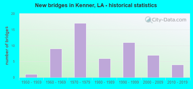
- New bridges - historical statistics
- 11950-1959
- 91960-1969
- 171970-1979
- 61980-1989
- 111990-1999
- 72000-2009
- 42010-2019

- Reconstructed bridges - Historical Statistics
- 21980-1989
- 11990-1999


- Bridge Condition - Deck
- 10.5%Very good
- 44.7%Good
- 26.3%Satisfactory
- 10.5%Fair
- 2.6%Poor
- 2.6%Serious
- 2.6%Failed

- Bridge Condition - Superstructure
- 18.4%Very good
- 50.0%Good
- 18.4%Satisfactory
- 7.9%Fair
- 2.6%Poor
- 2.6%Failed

- Bridge Condition - Substructure
- 15.8%Very good
- 39.5%Good
- 31.6%Satisfactory
- 10.5%Fair
- 2.6%Failed

- Bridge Condition - Channel
- 45.5%Very good
- 38.6%Good
- 11.4%Satisfactory
- 2.3%Fair
- 2.3%Poor

- Bridge Condition - Culverts
- 23.5%Very good
- 70.6%Good
- 5.9%Satisfactory
Find on map >> Show street view
Structure Number: 22600000020094, Location: 0.15 MILES WEST OF SHARON (Lat: 30.002250, Lng: -90.274550), Route carried "on" structure: County highway , Year Built: 2010, Status: Open, Structure Length: 1.83m (6.00ft), Design Load: HS 20, Features Intersected: CA-BUTLER CANAL #17, Facility Carried by Structure: 26TH ST
Minimum Vertical Clearance: 30+ m (98+ ft), Kilometerpoint: 0.000, Lanes on structure: 2, Owner: City or Municipal Highway Agency, Approaching Roadway Width: 8.5m (27.9ft), Skew: 30 degrees, Material/Design: Concrete, Design/Construction: Slab, Number Of Spans In Main Unit: 3, Length of Maximum Span: 6.1m (20.0ft), Curb-To-Curb Width: 8.5m (27.9ft), Out-to-Out Width: 9.4m (30.8ft)
Condition: Deck: Good, Superstructure: Good, Substructure: Very good, Channel: Very good, Operating Rating: 40.8 metric tons, Method Used To Determine Operating Rating: Load and Resistance Factor Rating (LRFR) rating reported by rating factor(RF) method using HL-93 loadings, Inventory Rating: 31.4 metric tons, Method Used To Determine Inventory Rating: Load and Resistance Factor Rating (LRFR) rating reported by rating factor(RF) method using HL-93 loadings, Structural Evaluation: Better than present minimum criteria, Deck Geometry: Better than present minimum criteria, Waterway Adequacy: Equal to present desirable criteria, Approach Roadway Alignment: Equal to present minimum criteria, Designated Inspection Frequency: Every 24 months, Inspection Date: March 2021, Deck Structure Type: Concrete Cast-file-Place
Find on map >> Show street view
Structure Number: 22600000020527, Location: 0.1 MI. S OF I-10 (Lat: 30.004789, Lng: -90.274650), Route carried "on" structure: County highway , Year Built: 2015, Status: Open, Structure Length: 2.44m (8.01ft), Design Load: HS 20, Features Intersected: CANAL 17, Facility Carried by Structure: VETERANS BLVD
Minimum Vertical Clearance: 30+ m (98+ ft), Kilometerpoint: 0.000, Lanes on structure: 2, Owner: City or Municipal Highway Agency, Approaching Roadway Width: 8.5m (27.9ft), Skew: 30 degrees, Material/Design: Concrete, Design/Construction: Slab, Number Of Spans In Main Unit: 4, Length of Maximum Span: 6.1m (20.0ft), Curb-To-Curb Width: 8.5m (27.9ft), Out-to-Out Width: 9.3m (30.5ft)
Condition: Deck: Very good, Superstructure: Very good, Substructure: Very good, Channel: Good, Operating Rating: 57.7 metric tons, Method Used To Determine Operating Rating: Load and Resistance Factor Rating (LRFR) rating reported by rating factor(RF) method using HL-93 loadings, Inventory Rating: 44.4 metric tons, Method Used To Determine Inventory Rating: Load and Resistance Factor Rating (LRFR) rating reported by rating factor(RF) method using HL-93 loadings, Structural Evaluation: Equal to present desirable criteria, Deck Geometry: Better than present minimum criteria, Waterway Adequacy: Superior to present desirable criteria, Approach Roadway Alignment: Equal to present desirable criteria, Designated Inspection Frequency: Every 24 months, Inspection Date: March 2021, Deck Structure Type: Concrete Cast-file-Place, Wearing Surface/Protective System: Wearing Surface: Bituminous
Find on map >> Show street view
Structure Number: 22600000020542, Location: .5 M. S. OF VETERANS BLVD (Lat: 29.999989, Lng: -90.274511), Route carried "on" structure: County highway , Year Built: 2017, Status: Open, Structure Length: 1.83m (6.00ft), Average Daily Traffic: 350 (year 2016), Average Future Daily Traffic: 500 (year 2036), Design Load: HL 93, Features Intersected: CANAL #17, Facility Carried by Structure: 23RD STREET
Minimum Vertical Clearance: 30+ m (98+ ft), Kilometerpoint: 0.016, Lanes on structure: 2, Owner: City or Municipal Highway Agency, Approaching Roadway Width: 9.8m (32.2ft), Material/Design: Concrete, Design/Construction: Slab, Number Of Spans In Main Unit: 3, Length of Maximum Span: 6.1m (20.0ft), Curb-To-Curb Width: 9.8m (32.2ft), Out-to-Out Width: 11.7m (38.4ft)
Condition: Deck: Good, Superstructure: Good, Substructure: Very good, Channel: Good, Operating Rating: 59.9 metric tons, Method Used To Determine Operating Rating: Load and Resistance Factor Rating (LRFR) rating reported by rating factor(RF) method using HL-93 loadings, Inventory Rating: 46.0 metric tons, Method Used To Determine Inventory Rating: Load and Resistance Factor Rating (LRFR) rating reported by rating factor(RF) method using HL-93 loadings, Structural Evaluation: Better than present minimum criteria, Deck Geometry: Better than present minimum criteria, Waterway Adequacy: Equal to present desirable criteria, Approach Roadway Alignment: Equal to present desirable criteria, Designated Inspection Frequency: Every 24 months, Inspection Date: Febuary 2021, Deck Structure Type: Concrete Cast-file-Place
Find on map >> Show street view
Structure Number: 22600000020556, Location: 0.5 MI W OF LA 49 (Lat: 30.031450, Lng: -90.246761), Route carried "on" structure: County highway , Year Built: 2005, Status: Open, Structure Length: 5.09m (16.70ft), Average Daily Traffic: 2,000 (year 2016), Average Future Daily Traffic: 2,200 (year 2036), Features Intersected: DUNCAN CANAL, Facility Carried by Structure: VINTAGE DRIVE
Minimum Vertical Clearance: 30+ m (98+ ft), Kilometerpoint: 2.813, Lanes on structure: 2, Owner: County Highway Agency, Approaching Roadway Width: 8.4m (27.6ft), Material/Design: Concrete, Design/Construction: Slab, Number Of Spans In Main Unit: 7, Length of Maximum Span: 7.6m (24.9ft), Curb-To-Curb Width: 8.4m (27.6ft), Out-to-Out Width: 9.0m (29.5ft)
Condition: Deck: Very good, Superstructure: Very good, Substructure: Good, Channel: Good, Operating Rating: 39.9 metric tons, Method Used To Determine Operating Rating: Load Factor (LF), Inventory Rating: 32.7 metric tons, Method Used To Determine Inventory Rating: Load Factor (LF), Structural Evaluation: Better than present minimum criteria, Deck Geometry: High priority of corrective action, Waterway Adequacy: Better than present minimum criteria, Approach Roadway Alignment: Equal to present desirable criteria, Designated Inspection Frequency: Every 24 months, Underwater Inspection Frequency: Every 60 months, Inspection Date: December 2020, Underwater Inspection Date: December 2018, Deck Structure Type: Concrete Cast-file-Place
Find on map >> Show street view
Structure Number: 22600000100213, Location: 0.3 MI. W. OF WILLIAMS BL (Lat: 30.020019, Lng: -90.244250), Route carried "on" structure: County highway , Year Built: 2011, Status: Open, Structure Length: 0.88m (2.89ft), Design Load: HS 20, Features Intersected: CANAL NO. 2, Facility Carried by Structure: CALIFORNIA AVE
Minimum Vertical Clearance: 30+ m (98+ ft), Kilometerpoint: 0.000, Lanes on structure: 2, Owner: County Highway Agency, Approaching Roadway Width: 7.3m (24.0ft), Skew: 30 degrees, Material/Design: Concrete, Design/Construction: Culvert, Number Of Spans In Main Unit: 3, Length of Maximum Span: 2.7m (8.9ft)
Condition: Channel: Very good, Culverts: Good, Operating Rating: 42.1 metric tons, Method Used To Determine Operating Rating: Load and Resistance Factor Rating (LRFR) rating reported by rating factor(RF) method using HL-93 loadings, Inventory Rating: 32.4 metric tons, Method Used To Determine Inventory Rating: Load and Resistance Factor Rating (LRFR) rating reported by rating factor(RF) method using HL-93 loadings, Structural Evaluation: Better than present minimum criteria, Waterway Adequacy: Better than present minimum criteria, Approach Roadway Alignment: Meets minimum limits, Designated Inspection Frequency: Every 24 months, Inspection Date: April 2021, Deck Structure Type: Concrete Cast-file-Place
Find on map >> Show street view
Structure Number: 22600000100217, Location: 1 MILE NORTH OF WEST ESPL (Lat: 30.037800, Lng: -90.251050), Route carried "on" structure: County highway , Year Built: 2008, Status: Open, Structure Length: 1.31m (4.30ft), Design Load: HS 20, Features Intersected: CANAL#7, Facility Carried by Structure: Chateau BLVD
Minimum Vertical Clearance: 30+ m (98+ ft), Kilometerpoint: 0.000, Lanes on structure: 4, Owner: City or Municipal Highway Agency, Approaching Roadway Width: 15.2m (49.9ft), Skew: 30 degrees, Material/Design: Concrete, Design/Construction: Culvert, Number Of Spans In Main Unit: 2, Length of Maximum Span: 6.1m (20.0ft), Curb or Sidewalk Widths: Left: 2.0m (6.6ft), Right: 2.0m (6.6ft), Curb-To-Curb Width: 15.2m (49.9ft), Out-to-Out Width: 35.1m (115.2ft)
Condition: Channel: Very good, Culverts: Very good, Operating Rating: 32.4 metric tons, Method Used To Determine Operating Rating: Assigned ratings based on Load and Resistance Factor Design (LRFD) reported by rating factor (RF) using HL93 loadings, Inventory Rating: 24.9 metric tons, Method Used To Determine Inventory Rating: Assigned ratings based on Load and Resistance Factor Design (LRFD) reported by rating factor (RF) using HL93 loadings, Structural Evaluation: Equal to present minimum criteria, Deck Geometry: High priority of corrective action, Waterway Adequacy: Better than present minimum criteria, Approach Roadway Alignment: Somewhat better than minimum adequacy, Designated Inspection Frequency: Every 24 months, Inspection Date: March 2021, Deck Structure Type: Other
Find on map >> Show street view
Structure Number: 22600070208591, Location: 0.1 MI EAST OF LA 611-9 (Lat: 29.982161, Lng: -90.269100), Route carried "on" structure: US 61, Year Built: 1976, Status: Open, Structure Length: 44.87m (147.21ft), Average Daily Traffic: 13,150 (year 2016), Truck Traffic: 10%, Average Future Daily Traffic: 26,928 (year 2036), Design Load: HS 20, Features Intersected: KENNER O'PASS RR
Minimum Vertical Clearance: 30+ m (98+ ft), Kilometerpoint: 1.104, Lanes on structure: 2, Lanes under structure: 2, Base Highway Network: Yes (Inventory Route: 7-02-2, Subroute: 10), Owner: State Highway Agency, Approaching Roadway Width: 28.7m (94.2ft), Skew: 35 degrees, Material/Design: Prestressed concrete, Design/Construction: Stringer/Multi-beam, Number Of Spans In Main Unit: 18, Number Of Approach Spans: 12, Length of Maximum Span: 23.2m (76.1ft), Curb-To-Curb Width: 10.4m (34.1ft), Out-to-Out Width: 26.6m (87.3ft)
Condition: Deck: Satisfactory, Superstructure: Good, Substructure: Satisfactory, Operating Rating: 53.5 metric tons, Method Used To Determine Operating Rating: Load Factor (LF), Inventory Rating: 31.7 metric tons, Method Used To Determine Inventory Rating: Load Factor (LF), Structural Evaluation: Equal to present minimum criteria, Deck Geometry: Somewhat better than minimum adequacy, Underclear: Better than present minimum criteria, Approach Roadway Alignment: Equal to present desirable criteria, Designated Inspection Frequency: Every 24 months, Inspection Date: October 2021, Deck Structure Type: Concrete Cast-file-Place
Find on map >> Show street view
Structure Number: 22600070208592, Location: 0.1 MI EAST OF LA 611-9 (Lat: 29.983361, Lng: -90.264700), Route carried "on" structure: US 61, Year Built: 1976, Status: Open, Structure Length: 44.87m (147.21ft), Average Daily Traffic: 13,150 (year 2016), Truck Traffic: 10%, Average Future Daily Traffic: 26,928 (year 2036), Design Load: HS 20, Features Intersected: KENNER O'PASS
Minimum Vertical Clearance: 30+ m (98+ ft), Kilometerpoint: 13.470, Lanes on structure: 2, Lanes under structure: 2, Base Highway Network: Yes (Inventory Route: 7-02-1, Subroute: 10), Owner: State Highway Agency, Approaching Roadway Width: 28.7m (94.2ft), Skew: 35 degrees, Material/Design: Prestressed concrete, Design/Construction: Stringer/Multi-beam, Number Of Spans In Main Unit: 18, Number Of Approach Spans: 12, Length of Maximum Span: 23.2m (76.1ft), Curb-To-Curb Width: 10.4m (34.1ft), Out-to-Out Width: 26.6m (87.3ft)
Condition: Deck: Satisfactory, Superstructure: Good, Substructure: Satisfactory, Operating Rating: 53.5 metric tons, Method Used To Determine Operating Rating: Load Factor (LF), Inventory Rating: 31.7 metric tons, Method Used To Determine Inventory Rating: Load Factor (LF), Structural Evaluation: Equal to present minimum criteria, Deck Geometry: Somewhat better than minimum adequacy, Underclear: Better than present minimum criteria, Approach Roadway Alignment: Equal to present desirable criteria, Designated Inspection Frequency: Every 24 months, Inspection Date: October 2021, Deck Structure Type: Concrete Cast-file-Place
Find on map >> Show street view
Structure Number: 22602833000611, Location: 02262833000611 (Lat: 30.030689, Lng: -90.238300), Route carried "on" structure: State highway 49, Year Built: 1970, Year Reconstructed: 1990, Status: Open, Structure Length: 0.91m (2.99ft), Average Daily Traffic: 45,100 (year 2016), Truck Traffic: 11%, Average Future Daily Traffic: 76,670 (year 2036), Design Load: HS 20, Features Intersected: DRAIN
Minimum Vertical Clearance: 30+ m (98+ ft), Kilometerpoint: 5.695, Lanes on structure: 8, Owner: State Highway Agency, Approaching Roadway Width: 34.4m (112.9ft), Skew: 30 degrees, Material/Design: Concrete, Design/Construction: Culvert, Number Of Spans In Main Unit: 4, Length of Maximum Span: 2.1m (6.9ft)
Condition: Channel: Very good, Culverts: Good, Operating Rating: 42.1 metric tons, Method Used To Determine Operating Rating: Load and Resistance Factor Rating (LRFR) rating reported by rating factor(RF) method using HL-93 loadings, Inventory Rating: 32.4 metric tons, Method Used To Determine Inventory Rating: Load and Resistance Factor Rating (LRFR) rating reported by rating factor(RF) method using HL-93 loadings, Structural Evaluation: Better than present minimum criteria, Waterway Adequacy: Equal to present desirable criteria, Approach Roadway Alignment: Equal to present desirable criteria, Designated Inspection Frequency: Every 24 months, Inspection Date: March 2021, Deck Structure Type: Concrete Cast-file-Place
Find on map >> Show street view
Structure Number: 22602833000991, Location: 1.0 MI NORTH OFI-10 (Lat: 30.019669, Lng: -90.239239), Route carried "on" structure: State highway 49, Year Built: 1970, Year Reconstructed: 1986, Status: Open, Structure Length: 0.91m (2.99ft), Average Daily Traffic: 45,100 (year 2016), Truck Traffic: 11%, Average Future Daily Traffic: 76,670 (year 2036), Design Load: HS 20, Features Intersected: DRAIN
Minimum Vertical Clearance: 30+ m (98+ ft), Kilometerpoint: 1.820, Lanes on structure: 8, Owner: State Highway Agency, Approaching Roadway Width: 30.8m (101.0ft), Skew: 30 degrees, Material/Design: Concrete, Design/Construction: Culvert, Number Of Spans In Main Unit: 7, Length of Maximum Span: 1.2m (3.9ft)
Condition: Channel: Good, Culverts: Good, Operating Rating: 42.1 metric tons, Method Used To Determine Operating Rating: Load and Resistance Factor Rating (LRFR) rating reported by rating factor(RF) method using HL-93 loadings, Inventory Rating: 32.4 metric tons, Method Used To Determine Inventory Rating: Load and Resistance Factor Rating (LRFR) rating reported by rating factor(RF) method using HL-93 loadings, Structural Evaluation: Better than present minimum criteria, Waterway Adequacy: Equal to present desirable criteria, Approach Roadway Alignment: Equal to present desirable criteria, Designated Inspection Frequency: Every 24 months, Inspection Date: October 2021, Deck Structure Type: Concrete Cast-file-Place
Find on map >> Show street view
Structure Number: 22602833003431, Location: 1.35 MI SOUTH OF I-10 (Lat: 29.990519, Lng: -90.241900), Route carried "on" structure: State highway 49, Year Built: 1955, Status: Open, Structure Length: 1.31m (4.30ft), Average Daily Traffic: 19,900 (year 2016), Truck Traffic: 10%, Average Future Daily Traffic: 33,830 (year 2036), Design Load: HS 20, Features Intersected: DRAIN
Minimum Vertical Clearance: 30+ m (98+ ft), Kilometerpoint: 5.081, Lanes on structure: 2, Base Highway Network: Yes (Inventory Route: 283-30-1, Subroute: 10), Owner: State Highway Agency, Approaching Roadway Width: 18.3m (60.0ft), Material/Design: Concrete, Design/Construction: Culvert, Number Of Spans In Main Unit: 5, Length of Maximum Span: 2.4m (7.9ft), Curb or Sidewalk Widths: Left: 0.0m, Right: 1.2m (3.9ft)
Condition: Channel: Good, Culverts: Good, Operating Rating: 42.1 metric tons, Method Used To Determine Operating Rating: Load and Resistance Factor Rating (LRFR) rating reported by rating factor(RF) method using HL-93 loadings, Inventory Rating: 32.4 metric tons, Method Used To Determine Inventory Rating: Load and Resistance Factor Rating (LRFR) rating reported by rating factor(RF) method using HL-93 loadings, Structural Evaluation: Better than present minimum criteria, Waterway Adequacy: Better than present minimum criteria, Approach Roadway Alignment: Equal to present desirable criteria, Designated Inspection Frequency: Every 24 months, Inspection Date: April 2020, Deck Structure Type: Concrete Cast-file-Place
Find on map >> Show street view
Structure Number: 22604501500451, Location: 1.2 MI EAST OF I-310 (Lat: 30.007289, Lng: -90.269500), Route carried "on" structure: Interstate 10, Year Built: 1971, Status: Open, Structure Length: 62.70m (205.71ft), Average Daily Traffic: 32,050 (year 2018), Truck Traffic: 25%, Average Future Daily Traffic: 126,072 (year 2036), Design Load: HS 20, Features Intersected: LOYOLA AVE.
Minimum Vertical Clearance: 30+ m (98+ ft), Kilometerpoint: 0.982, Lanes on structure: 3, Lanes under structure: 4, Base Highway Network: Yes (Inventory Route: 450-15-1, Subroute: 10), Owner: State Highway Agency, Approaching Roadway Width: 24.1m (79.1ft), Skew: 10 degrees, Material/Design: Prestressed concrete, Design/Construction: Stringer/Multi-beam, Number Of Spans In Main Unit: 20, Number Of Approach Spans: 24, Length of Maximum Span: 25.9m (85.0ft), Curb-To-Curb Width: 15.5m (50.9ft), Out-to-Out Width: 17.0m (55.8ft)
Condition: Deck: Fair, Superstructure: Good, Substructure: Very good, Operating Rating: 37.6 metric tons, Method Used To Determine Operating Rating: Load and Resistance Factor Rating (LRFR) rating reported by rating factor(RF) method using HL-93 loadings, Inventory Rating: 22.7 metric tons, Method Used To Determine Inventory Rating: Load and Resistance Factor Rating (LRFR) rating reported by rating factor(RF) method using HL-93 loadings, Structural Evaluation: Somewhat better than minimum adequacy, Deck Geometry: Somewhat better than minimum adequacy, Underclear: Meets minimum limits, Approach Roadway Alignment: Equal to present desirable criteria, Length Of Structure Improvement: 62.70m (205.71ft), Designated Inspection Frequency: Every 24 months, Inspection Date: November 2021, Bridge Improvement Cost: $6,818,000, Total Project Cost: $10,227,000 ( Estimate for 2016), Deck Structure Type: Concrete Cast-file-Place
Find on map >> Show street view
Structure Number: 22604501500452, Location: 1.2 MI EAST OF I-310 (Lat: 30.008061, Lng: -90.263000), Route carried "on" structure: Interstate 10, Year Built: 1971, Status: Open, Structure Length: 62.70m (205.71ft), Average Daily Traffic: 61,800 (year 2016), Truck Traffic: 25%, Average Future Daily Traffic: 64,464 (year 2036), Design Load: HS 20, Features Intersected: LOYOLA AVE
Minimum Vertical Clearance: 30+ m (98+ ft), Kilometerpoint: 13.692, Lanes on structure: 3, Lanes under structure: 4, Base Highway Network: Yes (Inventory Route: 450-15-2, Subroute: 10), Owner: State Highway Agency, Approaching Roadway Width: 24.1m (79.1ft), Skew: 10 degrees, Material/Design: Prestressed concrete, Design/Construction: Stringer/Multi-beam, Number Of Spans In Main Unit: 20, Number Of Approach Spans: 24, Length of Maximum Span: 25.9m (85.0ft), Curb-To-Curb Width: 15.5m (50.9ft), Out-to-Out Width: 17.0m (55.8ft)
Condition: Deck: Fair, Superstructure: Good, Substructure: Good, Operating Rating: 30.1 metric tons, Method Used To Determine Operating Rating: Load and Resistance Factor Rating (LRFR) rating reported by rating factor(RF) method using HL-93 loadings, Inventory Rating: 23.0 metric tons, Method Used To Determine Inventory Rating: Load and Resistance Factor Rating (LRFR) rating reported by rating factor(RF) method using HL-93 loadings, Structural Evaluation: Somewhat better than minimum adequacy, Deck Geometry: Somewhat better than minimum adequacy, Underclear: Meets minimum limits, Approach Roadway Alignment: Equal to present desirable criteria, Designated Inspection Frequency: Every 24 months, Inspection Date: November 2021, Deck Structure Type: Concrete Cast-file-Place
Find on map >> Show street view
Structure Number: 22604501501641, Location: 2.4 MI EAST OF I-310 (Lat: 30.008819, Lng: -90.249700), Route carried "on" structure: Interstate 10, Year Built: 1971, Status: Open, Structure Length: 0.91m (2.99ft), Average Daily Traffic: 141,400 (year 2016), Truck Traffic: 25%, Average Future Daily Traffic: 210,120 (year 2036), Design Load: HS 20, Features Intersected: CANAL NO. 19
Minimum Vertical Clearance: 30+ m (98+ ft), Kilometerpoint: 2.894, Lanes on structure: 6, Base Highway Network: Yes (Inventory Route: 450-15-1, Subroute: 10), Owner: State Highway Agency, Approaching Roadway Width: 48.8m (160.1ft), Skew: 11 degrees, Material/Design: Concrete, Design/Construction: Culvert, Number Of Spans In Main Unit: 4, Length of Maximum Span: 2.1m (6.9ft)
Condition: Channel: Good, Culverts: Good, Operating Rating: 42.1 metric tons, Method Used To Determine Operating Rating: Load and Resistance Factor Rating (LRFR) rating reported by rating factor(RF) method using HL-93 loadings, Inventory Rating: 32.4 metric tons, Method Used To Determine Inventory Rating: Load and Resistance Factor Rating (LRFR) rating reported by rating factor(RF) method using HL-93 loadings, Structural Evaluation: Better than present minimum criteria, Waterway Adequacy: Equal to present desirable criteria, Approach Roadway Alignment: Equal to present desirable criteria, Designated Inspection Frequency: Every 24 months, Inspection Date: July 2020, Deck Structure Type: Concrete Cast-file-Place
Find on map >> Show street view
Structure Number: 22604501501901, Location: 2.7 MI EAST OF I-310 (Lat: 30.009150, Lng: -90.245400), Route carried "on" structure: Interstate 10, Year Built: 1967, Status: Open, Structure Length: 6.86m (22.51ft), Average Daily Traffic: 70,700 (year 2016), Truck Traffic: 25%, Average Future Daily Traffic: 126,072 (year 2036), Design Load: HS 20, Features Intersected: DUNCAN CANAL
Minimum Vertical Clearance: 30+ m (98+ ft), Kilometerpoint: 3.310, Lanes on structure: 3, Base Highway Network: Yes (Inventory Route: 450-15-1, Subroute: 10), Owner: State Highway Agency, Approaching Roadway Width: 21.3m (69.9ft), Skew: 11 degrees, Material/Design: Concrete, Design/Construction: Slab, Number Of Spans In Main Unit: 9, Length of Maximum Span: 7.6m (24.9ft), Curb-To-Curb Width: 15.9m (52.2ft), Out-to-Out Width: 17.0m (55.8ft)
Condition: Deck: Satisfactory, Superstructure: Satisfactory, Substructure: Satisfactory, Channel: Very good, Operating Rating: 43.1 metric tons, Method Used To Determine Operating Rating: Load and Resistance Factor Rating (LRFR) rating reported by rating factor(RF) method using HL-93 loadings, Inventory Rating: 33.4 metric tons, Method Used To Determine Inventory Rating: Load and Resistance Factor Rating (LRFR) rating reported by rating factor(RF) method using HL-93 loadings, Structural Evaluation: Equal to present minimum criteria, Deck Geometry: Somewhat better than minimum adequacy, Waterway Adequacy: Equal to present desirable criteria, Approach Roadway Alignment: Equal to present desirable criteria, Designated Inspection Frequency: Every 24 months, Inspection Date: July 2020, Deck Structure Type: Concrete Cast-file-Place
Find on map >> Show street view
Structure Number: 22604501501902, Location: 2.7 MI EAST OF I-310 (Lat: 30.009461, Lng: -90.244800), Route carried "on" structure: Interstate 10, Year Built: 1967, Status: Open, Structure Length: 6.86m (22.51ft), Average Daily Traffic: 70,700 (year 2016), Truck Traffic: 25%, Average Future Daily Traffic: 126,072 (year 2036), Design Load: HS 20, Features Intersected: DUNCAN CANAL
Minimum Vertical Clearance: 30+ m (98+ ft), Kilometerpoint: 11.927, Lanes on structure: 3, Base Highway Network: Yes (Inventory Route: 450-15-2, Subroute: 10), Owner: State Highway Agency, Approaching Roadway Width: 21.3m (69.9ft), Skew: 11 degrees, Material/Design: Concrete, Design/Construction: Slab, Number Of Spans In Main Unit: 9, Length of Maximum Span: 7.6m (24.9ft), Curb-To-Curb Width: 15.9m (52.2ft), Out-to-Out Width: 17.0m (55.8ft)
Condition: Deck: Good, Superstructure: Good, Substructure: Satisfactory, Channel: Very good, Operating Rating: 43.4 metric tons, Method Used To Determine Operating Rating: Load and Resistance Factor Rating (LRFR) rating reported by rating factor(RF) method using HL-93 loadings, Inventory Rating: 33.4 metric tons, Method Used To Determine Inventory Rating: Load and Resistance Factor Rating (LRFR) rating reported by rating factor(RF) method using HL-93 loadings, Structural Evaluation: Equal to present minimum criteria, Deck Geometry: Somewhat better than minimum adequacy, Waterway Adequacy: Equal to present desirable criteria, Approach Roadway Alignment: Equal to present desirable criteria, Designated Inspection Frequency: Every 24 months, Inspection Date: July 2020, Deck Structure Type: Concrete Cast-file-Place
Find on map >> Show street view
Structure Number: 22604501502058, Location: 02264501502058 (Lat: 30.010050, Lng: -90.240700), Route carried "on" structure: Ramp Interstate 10, Year Built: 2001, Status: Open, Structure Length: 34.20m (112.20ft), Average Daily Traffic: 14,140 (year 2016), Truck Traffic: 25%, Average Future Daily Traffic: 21,012 (year 2036), Design Load: HS 20, Features Intersected: I-10 W.B. ON-RAMP
Minimum Vertical Clearance: 30+ m (98+ ft), Kilometerpoint: 0.103, Lanes on structure: 1, Lanes under structure: 2, Owner: State Highway Agency, Approaching Roadway Width: 7.9m (25.9ft), Material/Design: Prestressed concrete, Design/Construction: Stringer/Multi-beam, Number Of Spans In Main Unit: 11, Number Of Approach Spans: 12, Length of Maximum Span: 30.2m (99.1ft), Curb-To-Curb Width: 7.9m (25.9ft), Out-to-Out Width: 8.8m (28.9ft)
Condition: Deck: Good, Superstructure: Very good, Substructure: Very good, Operating Rating: 44.7 metric tons, Method Used To Determine Operating Rating: Load and Resistance Factor Rating (LRFR) rating reported by rating factor(RF) method using HL-93 loadings, Inventory Rating: 20.1 metric tons, Method Used To Determine Inventory Rating: Load and Resistance Factor Rating (LRFR) rating reported by rating factor(RF) method using HL-93 loadings, Structural Evaluation: Somewhat better than minimum adequacy, Deck Geometry: Equal to present desirable criteria, Underclear: Superior to present desirable criteria, Approach Roadway Alignment: Equal to present minimum criteria, Designated Inspection Frequency: Every 24 months, Inspection Date: July 2021, Deck Structure Type: Concrete Cast-file-Place, Wearing Surface/Protective System: Wearing Surface: Monolithic Concrete
Find on map >> Show street view
Structure Number: 22604501502061, Location: I-10 OVER LA 49 (Lat: 30.009311, Lng: -90.242800), Route carried "on" structure: Interstate 10, Year Built: 1968, Status: Open, Structure Length: 48.92m (160.50ft), Average Daily Traffic: 70,700 (year 2016), Truck Traffic: 25%, Average Future Daily Traffic: 144,024 (year 2036), Design Load: HS 20, Features Intersected: I-10 OVER WILLIAMS BLVD
Minimum Vertical Clearance: 30+ m (98+ ft), Kilometerpoint: 3.565, Lanes on structure: 3, Lanes under structure: 5, Base Highway Network: Yes (Inventory Route: 450-15-1, Subroute: 10), Owner: State Highway Agency, Approaching Roadway Width: 24.4m (80.1ft), Skew: 10 degrees, Material/Design: Prestressed concrete, Design/Construction: Stringer/Multi-beam, Number Of Spans In Main Unit: 23, Number Of Approach Spans: 10, Length of Maximum Span: 26.5m (86.9ft), Curb-To-Curb Width: 12.2m (40.0ft), Out-to-Out Width: 13.9m (45.6ft)
Condition: Deck: Satisfactory, Superstructure: Satisfactory, Substructure: Good, Operating Rating: 31.1 metric tons, Method Used To Determine Operating Rating: Load and Resistance Factor Rating (LRFR) rating reported by rating factor(RF) method using HL-93 loadings, Inventory Rating: 24.0 metric tons, Method Used To Determine Inventory Rating: Load and Resistance Factor Rating (LRFR) rating reported by rating factor(RF) method using HL-93 loadings, Structural Evaluation: Somewhat better than minimum adequacy, Deck Geometry: High priority of corrective action, Underclear: High priority of replacement, Approach Roadway Alignment: Equal to present desirable criteria, Length Of Structure Improvement: 48.92m (160.50ft), Designated Inspection Frequency: Every 24 months, Inspection Date: July 2020, Bridge Improvement Cost: $4,173,000, Total Project Cost: $6,259,000 ( Estimate for 2016), Deck Structure Type: Concrete Cast-file-Place
Find on map >> Show street view
Structure Number: 22604501502062, Location: I-10 OVER LA 49 (Lat: 30.009319, Lng: -90.237800), Route carried "on" structure: Interstate 10, Year Built: 1968, Status: Open, Structure Length: 48.92m (160.50ft), Average Daily Traffic: 70,700 (year 2016), Truck Traffic: 25%, Average Future Daily Traffic: 126,072 (year 2036), Design Load: HS 20, Features Intersected: I-10 OVER WILLIAMS BLVD
Minimum Vertical Clearance: 30+ m (98+ ft), Kilometerpoint: 11.253, Lanes on structure: 3, Lanes under structure: 5, Base Highway Network: Yes (Inventory Route: 450-15-2, Subroute: 10), Owner: State Highway Agency, Approaching Roadway Width: 24.4m (80.1ft), Skew: 10 degrees, Material/Design: Prestressed concrete, Design/Construction: Stringer/Multi-beam, Number Of Spans In Main Unit: 23, Number Of Approach Spans: 10, Length of Maximum Span: 26.5m (86.9ft), Curb-To-Curb Width: 12.2m (40.0ft), Out-to-Out Width: 13.9m (45.6ft)
Condition: Deck: Good, Superstructure: Good, Substructure: Satisfactory, Operating Rating: 31.1 metric tons, Method Used To Determine Operating Rating: Load and Resistance Factor Rating (LRFR) rating reported by rating factor(RF) method using HL-93 loadings, Inventory Rating: 24.0 metric tons, Method Used To Determine Inventory Rating: Load and Resistance Factor Rating (LRFR) rating reported by rating factor(RF) method using HL-93 loadings, Structural Evaluation: Somewhat better than minimum adequacy, Deck Geometry: High priority of corrective action, Underclear: High priority of replacement, Approach Roadway Alignment: Equal to present desirable criteria, Length Of Structure Improvement: 48.92m (160.50ft), Designated Inspection Frequency: Every 24 months, Inspection Date: July 2020, Bridge Improvement Cost: $4,173,000, Total Project Cost: $6,259,000 ( Estimate for 2016), Deck Structure Type: Concrete Cast-file-Place
Find on map >> Show street view
Structure Number: 22604501502065, Location: 02264501502065 (Lat: 30.012789, Lng: -90.240000), Route carried "on" structure: Ramp Interstate 10, Year Built: 2001, Status: Open, Structure Length: 90.22m (296.00ft), Average Daily Traffic: 14,140 (year 2016), Truck Traffic: 25%, Average Future Daily Traffic: 24,004 (year 2036), Design Load: HS 20, Features Intersected: LA 49; INTGS
Minimum Vertical Clearance: 30+ m (98+ ft), Kilometerpoint: 0.154, Lanes on structure: 1, Lanes under structure: 8, Owner: State Highway Agency, Approaching Roadway Width: 10.4m (34.1ft), Material/Design: Steel continuous, Design/Construction: Girder and Floorbeam System, Number Of Spans In Main Unit: 6, Number Of Approach Spans: 36, Length of Maximum Span: 47.2m (154.9ft), Curb-To-Curb Width: 10.4m (34.1ft), Out-to-Out Width: 11.3m (37.1ft)
Condition: Deck: Good, Superstructure: Good, Substructure: Satisfactory, Operating Rating: 31.1 metric tons, Method Used To Determine Operating Rating: Load and Resistance Factor Rating (LRFR) rating reported by rating factor(RF) method using HL-93 loadings, Inventory Rating: 20.7 metric tons, Method Used To Determine Inventory Rating: Load and Resistance Factor Rating (LRFR) rating reported by rating factor(RF) method using HL-93 loadings, Structural Evaluation: Somewhat better than minimum adequacy, Deck Geometry: Superior to present desirable criteria, Underclear: Equal to present minimum criteria, Approach Roadway Alignment: Equal to present desirable criteria, Designated Inspection Frequency: Every 24 months, Inspection Date: September 2021, Deck Structure Type: Concrete Cast-file-Place, Wearing Surface/Protective System: Wearing Surface: Monolithic Concrete
Find on map >> Show street view
Structure Number: 22604501502068, Location: 02264501502068 (Lat: 30.010931, Lng: -90.240361), Route carried "on" structure: Ramp Interstate 10, Year Built: 2001, Status: Open, Structure Length: 43.22m (141.80ft), Average Daily Traffic: 14,140 (year 2016), Truck Traffic: 25%, Average Future Daily Traffic: 24,004 (year 2036), Design Load: HS 20, Features Intersected: LA 49
Minimum Vertical Clearance: 30+ m (98+ ft), Kilometerpoint: 0.167, Lanes on structure: 1, Lanes under structure: 5, Owner: State Highway Agency, Approaching Roadway Width: 10.1m (33.1ft), Material/Design: Prestressed concrete, Design/Construction: Stringer/Multi-beam, Number Of Spans In Main Unit: 11, Number Of Approach Spans: 14, Length of Maximum Span: 28.0m (91.9ft), Curb-To-Curb Width: 10.1m (33.1ft), Out-to-Out Width: 11.0m (36.1ft)
Condition: Deck: Good, Superstructure: Very good, Substructure: Very good, Operating Rating: 42.1 metric tons, Method Used To Determine Operating Rating: Load and Resistance Factor Rating (LRFR) rating reported by rating factor(RF) method using HL-93 loadings, Inventory Rating: 28.8 metric tons, Method Used To Determine Inventory Rating: Load and Resistance Factor Rating (LRFR) rating reported by rating factor(RF) method using HL-93 loadings, Structural Evaluation: Better than present minimum criteria, Deck Geometry: Superior to present desirable criteria, Underclear: Superior to present desirable criteria, Approach Roadway Alignment: Equal to present desirable criteria, Designated Inspection Frequency: Every 24 months, Inspection Date: July 2020, Deck Structure Type: Concrete Cast-file-Place, Wearing Surface/Protective System: Wearing Surface: Monolithic Concrete
Find on map >> Show street view
Structure Number: 22604501502448, Location: .4 MI EAST OF LA 49 (Lat: 30.009689, Lng: -90.238500), Route carried "on" structure: Ramp Interstate 10, Year Built: 1979, Status: Open, Structure Length: 87.39m (286.71ft), Average Daily Traffic: 14,140 (year 2016), Truck Traffic: 25%, Average Future Daily Traffic: 24,004 (year 2036), Design Load: HS 20, Features Intersected: RAMP TO MOISANT AIRPORT
Minimum Vertical Clearance: 30+ m (98+ ft), Kilometerpoint: 0.399, Lanes on structure: 1, Lanes under structure: 10, Owner: State Highway Agency, Approaching Roadway Width: 9.1m (29.9ft), Material/Design: Prestressed concrete, Design/Construction: Stringer/Multi-beam, Number Of Spans In Main Unit: 35, Number Of Approach Spans: 15, Length of Maximum Span: 36.0m (118.1ft), Curb-To-Curb Width: 7.6m (24.9ft), Out-to-Out Width: 8.5m (27.9ft)
Condition: Deck: Satisfactory, Superstructure: Satisfactory, Substructure: Good, Operating Rating: 69.8 metric tons, Method Used To Determine Operating Rating: Load Factor (LF), Inventory Rating: 35.4 metric tons, Method Used To Determine Inventory Rating: Load Factor (LF), Structural Evaluation: Equal to present minimum criteria, Deck Geometry: Better than present minimum criteria, Underclear: Somewhat better than minimum adequacy, Approach Roadway Alignment: Equal to present desirable criteria, Designated Inspection Frequency: Every 24 months, Inspection Date: July 2021, Deck Structure Type: Concrete Cast-file-Place
Find on map >> Show street view
Structure Number: 22604501502465, Location: .4 MI EAST OF LA 49 (Lat: 30.007881, Lng: -90.243000), Route carried "on" structure: Ramp Interstate 10, Year Built: 1979, Status: Open, Structure Length: 54.32m (178.22ft), Average Daily Traffic: 14,140 (year 2016), Truck Traffic: 25%, Average Future Daily Traffic: 24,004 (year 2036), Design Load: HS 20, Features Intersected: Canal No. 3 & LA 49
Minimum Vertical Clearance: 30+ m (98+ ft), Kilometerpoint: 0.489, Lanes on structure: 1, Lanes under structure: 10, Owner: State Highway Agency, Approaching Roadway Width: 13.7m (44.9ft), Material/Design: Steel, Design/Construction: Stringer/Multi-beam, Number Of Spans In Main Unit: 1, Number Of Approach Spans: 29, Length of Maximum Span: 47.2m (154.9ft), Curb-To-Curb Width: 7.6m (24.9ft), Out-to-Out Width: 8.5m (27.9ft)
Condition: Deck: Good, Superstructure: Good, Substructure: Good, Operating Rating: 47.2 metric tons, Method Used To Determine Operating Rating: Load Factor (LF), Inventory Rating: 33.6 metric tons, Method Used To Determine Inventory Rating: Load Factor (LF), Structural Evaluation: Better than present minimum criteria, Deck Geometry: Better than present minimum criteria, Underclear: Somewhat better than minimum adequacy, Approach Roadway Alignment: Equal to present desirable criteria, Designated Inspection Frequency: Every 24 months, Inspection Date: September 2021, Deck Structure Type: Concrete Cast-file-Place
Find on map >> Show street view
Structure Number: 22629564901521, Location: 2.7 M NW OF US 90 (Lat: 29.940161, Lng: -90.252231), Route carried "on" structure: County highway , Year Built: 1988, Status: Open, Structure Length: 2.32m (7.61ft), Average Daily Traffic: 2,000 (year 1989), Average Future Daily Traffic: 3,400 (year 2036), Design Load: HS 20, Features Intersected: SAUL'S CANAL, Facility Carried by Structure: LIVE OAK BLVD
Minimum Vertical Clearance: 30+ m (98+ ft), Kilometerpoint: 0.000, Lanes on structure: 2, Owner: County Highway Agency, Approaching Roadway Width: 7.0m (23.0ft), Material/Design: Concrete, Design/Construction: Slab, Number Of Spans In Main Unit: 4, Length of Maximum Span: 5.8m (19.0ft), Curb or Sidewalk Widths: Left: 1.2m (3.9ft), Right: 0.0m, Curb-To-Curb Width: 10.0m (32.8ft), Out-to-Out Width: 11.9m (39.0ft)
Condition: Deck: Good, Superstructure: Good, Substructure: Good, Channel: Good, Operating Rating: 57.7 metric tons, Method Used To Determine Operating Rating: Load and Resistance Factor Rating (LRFR) rating reported by rating factor(RF) method using HL-93 loadings, Inventory Rating: 44.4 metric tons, Method Used To Determine Inventory Rating: Load and Resistance Factor Rating (LRFR) rating reported by rating factor(RF) method using HL-93 loadings, Structural Evaluation: Better than present minimum criteria, Deck Geometry: Somewhat better than minimum adequacy, Waterway Adequacy: Equal to present desirable criteria, Approach Roadway Alignment: Equal to present desirable criteria, Designated Inspection Frequency: Every 24 months, Inspection Date: January 2021, Deck Structure Type: Concrete Precast Panels, Wearing Surface/Protective System: Wearing Surface: Monolithic Concrete
Find on map >> Show street view
Structure Number: 22629593901401, Location: 0.7MI.E.OF WILLIAMS (Lat: 29.988850, Lng: -90.234250), Route carried "on" structure: County highway , Year Built: 1960, Status: Open, Structure Length: 0.76m (2.49ft), Average Daily Traffic: 1,000 (year 1989), Average Future Daily Traffic: 1,700 (year 2036), Design Load: HS 20, Features Intersected: CANAL NUMBER 5, Facility Carried by Structure: ROOSEVELT BLVD
Minimum Vertical Clearance: 30+ m (98+ ft), Kilometerpoint: 0.000, Lanes on structure: 4, Owner: City or Municipal Highway Agency, Approaching Roadway Width: 15.2m (49.9ft), Skew: 33 degrees, Material/Design: Concrete, Design/Construction: Culvert, Number Of Spans In Main Unit: 2, Length of Maximum Span: 3.4m (11.2ft), Curb or Sidewalk Widths: Left: 1.5m (4.9ft), Right: 1.6m (5.2ft), Curb-To-Curb Width: 15.4m (50.5ft), Out-to-Out Width: 30.5m (100.1ft)
Condition: Channel: Very good, Culverts: Satisfactory, Operating Rating: 42.1 metric tons, Method Used To Determine Operating Rating: Load and Resistance Factor Rating (LRFR) rating reported by rating factor(RF) method using HL-93 loadings, Inventory Rating: 32.4 metric tons, Method Used To Determine Inventory Rating: Load and Resistance Factor Rating (LRFR) rating reported by rating factor(RF) method using HL-93 loadings, Structural Evaluation: Equal to present minimum criteria, Deck Geometry: Meets minimum limits, Waterway Adequacy: Better than present minimum criteria, Approach Roadway Alignment: Equal to present minimum criteria, Designated Inspection Frequency: Every 24 months, Inspection Date: March 2021
Find on map >> Show street view
Structure Number: 22629594901441, Location: 0.0 MI. W.METAIRIE (Lat: 29.989931, Lng: -90.239439), Route carried "on" structure: County highway , Year Built: 1960, Status: Open, Structure Length: 0.79m (2.59ft), Average Daily Traffic: 2,000 (year 1979), Average Future Daily Traffic: 3,400 (year 2036), Design Load: HS 20, Features Intersected: CANAL NUMBER 5, Facility Carried by Structure: CLAY ST
Minimum Vertical Clearance: 30+ m (98+ ft), Kilometerpoint: 0.000, Lanes on structure: 2, Owner: City or Municipal Highway Agency, Approaching Roadway Width: 7.3m (24.0ft), Material/Design: Concrete, Design/Construction: Culvert, Number Of Spans In Main Unit: 2, Length of Maximum Span: 3.4m (11.2ft), Curb or Sidewalk Widths: Left: 1.5m (4.9ft), Right: 1.5m (4.9ft), Curb-To-Curb Width: 7.3m (24.0ft), Out-to-Out Width: 13.7m (44.9ft)
Condition: Channel: Very good, Culverts: Good, Operating Rating: 42.1 metric tons, Method Used To Determine Operating Rating: Load and Resistance Factor Rating (LRFR) rating reported by rating factor(RF) method using HL-93 loadings, Inventory Rating: 32.4 metric tons, Method Used To Determine Inventory Rating: Load and Resistance Factor Rating (LRFR) rating reported by rating factor(RF) method using HL-93 loadings, Structural Evaluation: Better than present minimum criteria, Deck Geometry: Meets minimum limits, Waterway Adequacy: Somewhat better than minimum adequacy, Approach Roadway Alignment: Equal to present minimum criteria, Designated Inspection Frequency: Every 24 months, Inspection Date: March 2021
Find on map >> Show street view
Structure Number: 22629598901401, Location: 0.6 MI. S.OF VETERAN (Lat: 29.997219, Lng: -90.233389), Route carried "on" structure: County highway , Year Built: 1960, Year Reconstructed: 1992, Status: Open, Structure Length: 0.79m (2.59ft), Average Daily Traffic: 10,000 (year 1989), Average Future Daily Traffic: 17,000 (year 2036), Design Load: HS 20, Features Intersected: CANAL NUMBER 4, Facility Carried by Structure: ROOSEVELT BLVD
Minimum Vertical Clearance: 30+ m (98+ ft), Kilometerpoint: 0.000, Lanes on structure: 2, Owner: City or Municipal Highway Agency, Approaching Roadway Width: 13.4m (44.0ft), Material/Design: Concrete, Design/Construction: Culvert, Number Of Spans In Main Unit: 2, Length of Maximum Span: 3.4m (11.2ft), Curb or Sidewalk Widths: Left: 1.2m (3.9ft), Right: 0.0m, Curb-To-Curb Width: 16.8m (55.1ft), Out-to-Out Width: 82.8m (271.7ft)
Condition: Channel: Very good, Culverts: Good, Operating Rating: 42.1 metric tons, Method Used To Determine Operating Rating: Load and Resistance Factor Rating (LRFR) rating reported by rating factor(RF) method using HL-93 loadings, Inventory Rating: 32.4 metric tons, Method Used To Determine Inventory Rating: Load and Resistance Factor Rating (LRFR) rating reported by rating factor(RF) method using HL-93 loadings, Structural Evaluation: Better than present minimum criteria, Deck Geometry: Superior to present desirable criteria, Waterway Adequacy: Better than present minimum criteria, Approach Roadway Alignment: Better than present minimum criteria, Designated Inspection Frequency: Every 24 months, Inspection Date: March 2021
Find on map >> Show street view
Structure Number: 22630000900741, Location: 0.2 MI. E. OF LAKE AVENUE (Lat: 29.999931, Lng: -90.123631), Route carried "on" structure: County highway , Year Built: 1997, Status: Open, Structure Length: 7.10m (23.29ft), Design Load: HS 20, Features Intersected: 17TH STREET CANAL, Facility Carried by Structure: VETERANS BLVD
Minimum Vertical Clearance: 30+ m (98+ ft), Kilometerpoint: 0.000, Lanes on structure: 3, Base Highway Network: Yes, Owner: County Highway Agency, Approaching Roadway Width: 14.6m (47.9ft), Material/Design: Prestressed concrete, Design/Construction: Stringer/Multi-beam, Number Of Spans In Main Unit: 5, Length of Maximum Span: 14.0m (45.9ft), Curb or Sidewalk Widths: Left: 0.0m, Right: 1.8m (5.9ft), Curb-To-Curb Width: 14.6m (47.9ft), Out-to-Out Width: 18.0m (59.1ft)
Condition: Deck: Good, Superstructure: Good, Substructure: Good, Channel: Very good, Operating Rating: 42.8 metric tons, Method Used To Determine Operating Rating: Load and Resistance Factor Rating (LRFR) rating reported by rating factor(RF) method using HL-93 loadings, Inventory Rating: 33.0 metric tons, Method Used To Determine Inventory Rating: Load and Resistance Factor Rating (LRFR) rating reported by rating factor(RF) method using HL-93 loadings, Structural Evaluation: Better than present minimum criteria, Deck Geometry: Somewhat better than minimum adequacy, Waterway Adequacy: Equal to present desirable criteria, Approach Roadway Alignment: Equal to present desirable criteria, Designated Inspection Frequency: Every 24 months, Underwater Inspection Frequency: Every 60 months, Inspection Date: May 2021, Underwater Inspection Date: July 2021, Deck Structure Type: Concrete Cast-file-Place, Wearing Surface/Protective System: Wearing Surface: Monolithic Concrete
Find on map >> Show street view
Structure Number: 22630001901501, Location: 0.5M SOUTH OF VETERAN (Lat: 30.001681, Lng: -90.249689), Route carried "on" structure: County highway , Year Built: 1970, Status: Open, Structure Length: 0.67m (2.20ft), Design Load: HS 20, Features Intersected: CANAL NUMBER 14, Facility Carried by Structure: BAINBRIDGE AVE
Minimum Vertical Clearance: 30+ m (98+ ft), Kilometerpoint: 0.000, Lanes on structure: 2, Owner: City or Municipal Highway Agency, Approaching Roadway Width: 7.3m (24.0ft), Material/Design: Concrete, Design/Construction: Culvert, Number Of Spans In Main Unit: 2, Length of Maximum Span: 3.0m (9.8ft)
Condition: Channel: Very good, Culverts: Very good, Operating Rating: 35.3 metric tons, Method Used To Determine Operating Rating: Load and Resistance Factor Rating (LRFR) rating reported by rating factor(RF) method using HL-93 loadings, Inventory Rating: 27.2 metric tons, Method Used To Determine Inventory Rating: Load and Resistance Factor Rating (LRFR) rating reported by rating factor(RF) method using HL-93 loadings, Structural Evaluation: Equal to present minimum criteria, Waterway Adequacy: Equal to present minimum criteria, Approach Roadway Alignment: Better than present minimum criteria, Designated Inspection Frequency: Every 24 months, Inspection Date: April 2021
Find on map >> Show street view
Structure Number: 22630004901461, Location: 0.2MI.W.OF WILLIAMS (Lat: 30.006781, Lng: -90.244400), Route carried "on" structure: County highway , Year Built: 1977, Status: Open, Structure Length: 0.67m (2.20ft), Average Daily Traffic: 10,500 (year 1979), Average Future Daily Traffic: 17,850 (year 2036), Design Load: HS 20, Features Intersected: DUNCAN CANAL, Facility Carried by Structure: VETERAN'S MEMORIAL
Minimum Vertical Clearance: 30+ m (98+ ft), Kilometerpoint: 0.000, Lanes on structure: 4, Owner: City or Municipal Highway Agency, Approaching Roadway Width: 14.0m (45.9ft), Skew: 31 degrees, Material/Design: Concrete, Design/Construction: Culvert, Number Of Spans In Main Unit: 2, Length of Maximum Span: 3.4m (11.2ft), Curb-To-Curb Width: 20.3m (66.6ft), Out-to-Out Width: 29.9m (98.1ft)
Condition: Channel: Very good, Culverts: Very good, Operating Rating: 42.1 metric tons, Method Used To Determine Operating Rating: Load and Resistance Factor Rating (LRFR) rating reported by rating factor(RF) method using HL-93 loadings, Inventory Rating: 32.4 metric tons, Method Used To Determine Inventory Rating: Load and Resistance Factor Rating (LRFR) rating reported by rating factor(RF) method using HL-93 loadings, Structural Evaluation: Equal to present desirable criteria, Deck Geometry: Equal to present desirable criteria, Waterway Adequacy: Better than present minimum criteria, Approach Roadway Alignment: Better than present minimum criteria, Designated Inspection Frequency: Every 24 months, Inspection Date: May 2021, Deck Structure Type: Concrete Cast-file-Place
Find on map >> Show street view
Structure Number: 22630005901521, Location: 0.3 MI N. OF W. ESPLANADE (Lat: 30.024789, Lng: -90.255331), Route carried "on" structure: County highway , Year Built: 1964, Status: Open, Structure Length: 1.01m (3.31ft), Design Load: HS 20, Features Intersected: CANAL NUMBER 11, Facility Carried by Structure: Chateau BLVD
Minimum Vertical Clearance: 30+ m (98+ ft), Kilometerpoint: 0.000, Lanes on structure: 4, Owner: City or Municipal Highway Agency, Approaching Roadway Width: 8.2m (26.9ft), Skew: 30 degrees, Material/Design: Concrete, Design/Construction: Culvert, Number Of Spans In Main Unit: 5, Length of Maximum Span: 1.8m (5.9ft), Curb or Sidewalk Widths: Left: 1.2m (3.9ft), Right: 0.0m
Condition: Channel: Good, Culverts: Good, Operating Rating: 42.1 metric tons, Method Used To Determine Operating Rating: Load and Resistance Factor Rating (LRFR) rating reported by rating factor(RF) method using HL-93 loadings, Inventory Rating: 32.4 metric tons, Method Used To Determine Inventory Rating: Load and Resistance Factor Rating (LRFR) rating reported by rating factor(RF) method using HL-93 loadings, Structural Evaluation: Better than present minimum criteria, Waterway Adequacy: Equal to present minimum criteria, Approach Roadway Alignment: Better than present minimum criteria, Designated Inspection Frequency: Every 24 months, Inspection Date: March 2021, Deck Structure Type: Concrete Cast-file-Place
Find on map >> Show street view
Structure Number: 22630005901601, Location: .4 MI. N. OF VETERAN (Lat: 30.008181, Lng: -90.266150), Route carried "on" structure: County highway , Year Built: 1970, Status: Open, Structure Length: 0.64m (2.10ft), Design Load: HS 20, Features Intersected: CANAL NO. 13, Facility Carried by Structure: Loyola Dr
Minimum Vertical Clearance: 30+ m (98+ ft), Kilometerpoint: 0.000, Lanes on structure: 7, Owner: City or Municipal Highway Agency, Approaching Roadway Width: 20.1m (65.9ft), Skew: 30 degrees, Material/Design: Concrete, Design/Construction: Culvert, Number Of Spans In Main Unit: 2, Length of Maximum Span: 2.7m (8.9ft), Curb or Sidewalk Widths: Left: 1.3m (4.3ft), Right: 1.3m (4.3ft)
Condition: Channel: Good, Culverts: Very good, Operating Rating: 42.1 metric tons, Method Used To Determine Operating Rating: Load and Resistance Factor Rating (LRFR) rating reported by rating factor(RF) method using HL-93 loadings, Inventory Rating: 32.4 metric tons, Method Used To Determine Inventory Rating: Load and Resistance Factor Rating (LRFR) rating reported by rating factor(RF) method using HL-93 loadings, Structural Evaluation: Equal to present desirable criteria, Waterway Adequacy: Better than present minimum criteria, Approach Roadway Alignment: Equal to present desirable criteria, Designated Inspection Frequency: Every 24 months, Inspection Date: April 2021
Find on map >> Show street view
Structure Number: 22630007901441, Location: 1.2 MI E OF LOYOLA AVENUE (Lat: 30.010500, Lng: -90.245600), Route carried "on" structure: County highway , Year Built: 1999, Status: Open, Structure Length: 3.51m (11.52ft), Design Load: HS 20, Features Intersected: DUNCAN CANAL, Facility Carried by Structure: 30TH STREET
Minimum Vertical Clearance: 30+ m (98+ ft), Kilometerpoint: 0.000, Lanes on structure: 2, Owner: City or Municipal Highway Agency, Approaching Roadway Width: 7.6m (24.9ft), Material/Design: Concrete, Design/Construction: Slab, Number Of Spans In Main Unit: 3, Length of Maximum Span: 13.7m (44.9ft), Curb or Sidewalk Widths: Left: 2.1m (6.9ft), Right: 0.0m, Curb-To-Curb Width: 9.8m (32.2ft), Out-to-Out Width: 12.5m (41.0ft)
Condition: Deck: Good, Superstructure: Good, Substructure: Good, Channel: Satisfactory, Operating Rating: 67.7 metric tons, Method Used To Determine Operating Rating: Load and Resistance Factor Rating (LRFR) rating reported by rating factor(RF) method using HL-93 loadings, Inventory Rating: 52.2 metric tons, Method Used To Determine Inventory Rating: Load and Resistance Factor Rating (LRFR) rating reported by rating factor(RF) method using HL-93 loadings, Structural Evaluation: Better than present minimum criteria, Deck Geometry: Equal to present desirable criteria, Waterway Adequacy: Better than present minimum criteria, Approach Roadway Alignment: Somewhat better than minimum adequacy, Designated Inspection Frequency: Every 24 months, Underwater Inspection Frequency: Every 60 months, Inspection Date: May 2021, Underwater Inspection Date: Febuary 2019, Deck Structure Type: Concrete Cast-file-Place, Wearing Surface/Protective System: Wearing Surface: Monolithic Concrete
Find on map >> Show street view
Structure Number: 22630007901471, Location: 1.2 MI. E. OF LOYOLA (Lat: 30.011861, Lng: -90.246031), Route carried "on" structure: County highway , Year Built: 2004, Status: Open, Structure Length: 1.80m (5.91ft), Design Load: HS 20, Features Intersected: DUNCAN CANAL, Facility Carried by Structure: 31st St
Minimum Vertical Clearance: 30+ m (98+ ft), Kilometerpoint: 0.000, Lanes on structure: 2, Owner: City or Municipal Highway Agency, Approaching Roadway Width: 6.1m (20.0ft), Skew: 1 degrees, Material/Design: Concrete, Design/Construction: Slab, Number Of Spans In Main Unit: 3, Length of Maximum Span: 6.4m (21.0ft), Curb or Sidewalk Widths: Left: 0.9m (3.0ft), Right: 0.0m, Curb-To-Curb Width: 7.2m (23.6ft), Out-to-Out Width: 8.6m (28.2ft)
Condition: Deck: Very good, Superstructure: Very good, Substructure: Satisfactory, Channel: Good, Operating Rating: 47.0 metric tons, Method Used To Determine Operating Rating: Load and Resistance Factor Rating (LRFR) rating reported by rating factor(RF) method using HL-93 loadings, Inventory Rating: 36.3 metric tons, Method Used To Determine Inventory Rating: Load and Resistance Factor Rating (LRFR) rating reported by rating factor(RF) method using HL-93 loadings, Structural Evaluation: Equal to present minimum criteria, Deck Geometry: Somewhat better than minimum adequacy, Waterway Adequacy: Equal to present desirable criteria, Approach Roadway Alignment: Better than present minimum criteria, Designated Inspection Frequency: Every 24 months, Underwater Inspection Frequency: Every 60 months, Inspection Date: May 2021, Underwater Inspection Date: December 2018, Deck Structure Type: Concrete Precast Panels, Wearing Surface/Protective System: Wearing Surface: Monolithic Concrete
Find on map >> Show street view
Structure Number: 22630009901481, Location: 0.5 MI W OF WILLIAMS BLVD (Lat: 30.014539, Lng: -90.246731), Route carried "on" structure: County highway , Year Built: 1984, Status: Open, Structure Length: 4.05m (13.29ft), Design Load: HS 20, Features Intersected: DUNCAN CANAL, Facility Carried by Structure: 32nd St
Minimum Vertical Clearance: 30+ m (98+ ft), Kilometerpoint: 0.000, Lanes on structure: 2, Owner: City or Municipal Highway Agency, Approaching Roadway Width: 8.5m (27.9ft), Skew: 10 degrees, Material/Design: Concrete, Design/Construction: Slab, Number Of Spans In Main Unit: 7, Length of Maximum Span: 5.8m (19.0ft), Curb or Sidewalk Widths: Left: 0.0m, Right: 1.2m (3.9ft), Curb-To-Curb Width: 8.6m (28.2ft), Out-to-Out Width: 10.7m (35.1ft)
Condition: Deck: Good, Superstructure: Good, Substructure: Satisfactory, Channel: Good, Operating Rating: 57.7 metric tons, Method Used To Determine Operating Rating: Load and Resistance Factor Rating (LRFR) rating reported by rating factor(RF) method using HL-93 loadings, Inventory Rating: 44.4 metric tons, Method Used To Determine Inventory Rating: Load and Resistance Factor Rating (LRFR) rating reported by rating factor(RF) method using HL-93 loadings, Structural Evaluation: Equal to present minimum criteria, Deck Geometry: High priority of corrective action, Waterway Adequacy: Better than present minimum criteria, Approach Roadway Alignment: Better than present minimum criteria, Designated Inspection Frequency: Every 24 months, Underwater Inspection Frequency: Every 60 months, Inspection Date: May 2021, Underwater Inspection Date: December 2018, Deck Structure Type: Concrete Precast Panels, Wearing Surface/Protective System: Wearing Surface: Monolithic Concrete
Find on map >> Show street view
Structure Number: 22630009901482, Location: 0.5 MI W OF WILLIAMS BLVD (Lat: 30.014631, Lng: -90.246319), Route carried "on" structure: County highway , Year Built: 1985, Status: Open, Structure Length: 4.05m (13.29ft), Design Load: HS 20, Features Intersected: DUNCAN CANAL, Facility Carried by Structure: 32nd St
Minimum Vertical Clearance: 30+ m (98+ ft), Kilometerpoint: 0.000, Lanes on structure: 2, Owner: City or Municipal Highway Agency, Approaching Roadway Width: 8.5m (27.9ft), Skew: 10 degrees, Material/Design: Concrete, Design/Construction: Slab, Number Of Spans In Main Unit: 7, Length of Maximum Span: 5.8m (19.0ft), Curb or Sidewalk Widths: Left: 1.2m (3.9ft), Right: 0.0m, Curb-To-Curb Width: 8.6m (28.2ft), Out-to-Out Width: 10.7m (35.1ft)
Condition: Deck: Good, Superstructure: Good, Substructure: Good, Channel: Good, Operating Rating: 57.7 metric tons, Method Used To Determine Operating Rating: Load and Resistance Factor Rating (LRFR) rating reported by rating factor(RF) method using HL-93 loadings, Inventory Rating: 44.4 metric tons, Method Used To Determine Inventory Rating: Load and Resistance Factor Rating (LRFR) rating reported by rating factor(RF) method using HL-93 loadings, Structural Evaluation: Better than present minimum criteria, Deck Geometry: High priority of corrective action, Waterway Adequacy: Better than present minimum criteria, Approach Roadway Alignment: Equal to present desirable criteria, Designated Inspection Frequency: Every 24 months, Underwater Inspection Frequency: Every 60 months, Inspection Date: May 2021, Underwater Inspection Date: December 2018, Deck Structure Type: Concrete Precast Panels, Wearing Surface/Protective System: Wearing Surface: Monolithic Concrete
Find on map >> Show street view
Structure Number: 22630012901441, Location: 0.2 WEST OF LA 49 (Lat: 30.019911, Lng: -90.242531), Route carried "on" structure: County highway , Year Built: 1994, Status: Open, Structure Length: 0.85m (2.79ft), Design Load: HS 20, Features Intersected: CANAL NO. 2, Facility Carried by Structure: Esplanade U-turn
Minimum Vertical Clearance: 30+ m (98+ ft), Kilometerpoint: 0.000, Lanes on structure: 2, Owner: City or Municipal Highway Agency, Approaching Roadway Width: 8.8m (28.9ft), Skew: 30 degrees, Material/Design: Concrete, Design/Construction: Culvert, Number Of Spans In Main Unit: 3, Length of Maximum Span: 2.7m (8.9ft), Curb-To-Curb Width: 8.8m (28.9ft), Out-to-Out Width: 105.2m (345.1ft)
Condition: Channel: Very good, Culverts: Good, Operating Rating: 42.1 metric tons, Method Used To Determine Operating Rating: Load and Resistance Factor Rating (LRFR) rating reported by rating factor(RF) method using HL-93 loadings, Inventory Rating: 32.4 metric tons, Method Used To Determine Inventory Rating: Load and Resistance Factor Rating (LRFR) rating reported by rating factor(RF) method using HL-93 loadings, Structural Evaluation: Better than present minimum criteria, Deck Geometry: Better than present minimum criteria, Waterway Adequacy: Equal to present desirable criteria, Approach Roadway Alignment: Equal to present desirable criteria, Designated Inspection Frequency: Every 24 months, Inspection Date: April 2021, Deck Structure Type: Concrete Cast-file-Place
Find on map >> Show street view
Structure Number: 22630012901481, Location: 0.3 MI. E. OF CHATEA (Lat: 30.020119, Lng: -90.246831), Route carried "on" structure: County highway , Year Built: 1970, Status: Open, Structure Length: 2.96m (9.71ft), Average Daily Traffic: 12,850 (year 1979), Average Future Daily Traffic: 21,845 (year 2036), Design Load: HS 20, Features Intersected: DUNCAN CANAL, Facility Carried by Structure: W Esplanade Ave S
Minimum Vertical Clearance: 30+ m (98+ ft), Kilometerpoint: 0.000, Lanes on structure: 2, Owner: City or Municipal Highway Agency, Approaching Roadway Width: 9.8m (32.2ft), Skew: 10 degrees, Material/Design: Concrete, Design/Construction: Slab, Number Of Spans In Main Unit: 5, Length of Maximum Span: 5.8m (19.0ft), Curb or Sidewalk Widths: Left: 0.0m, Right: 0.6m (2.0ft), Curb-To-Curb Width: 8.6m (28.2ft), Out-to-Out Width: 9.8m (32.2ft)
Condition: Deck: Fair, Superstructure: Fair, Substructure: Satisfactory, Channel: Good, Operating Rating: 27.2 metric tons, Method Used To Determine Operating Rating: Load and Resistance Factor Rating (LRFR) rating reported by rating factor(RF) method using HL-93 loadings, Inventory Rating: 18.8 metric tons, Method Used To Determine Inventory Rating: Load and Resistance Factor Rating (LRFR) rating reported by rating factor(RF) method using HL-93 loadings, Structural Evaluation: Meets minimum limits, Deck Geometry: High priority of corrective action, Waterway Adequacy: Better than present minimum criteria, Approach Roadway Alignment: Equal to present minimum criteria, Length Of Structure Improvement: 3.78m (12.40ft), Designated Inspection Frequency: Every 24 months, Underwater Inspection Frequency: Every 60 months, Inspection Date: May 2021, Underwater Inspection Date: December 2018, Bridge Improvement Cost: $227,000, Total Project Cost: $340,000 ( Estimate for 2016), Deck Structure Type: Concrete Cast-file-Place, Wearing Surface/Protective System: Wearing Surface: Monolithic Concrete
Find on map >> Show street view
Structure Number: 22630012901482, Location: .3MI. E.OF CHATEU BL (Lat: 30.020331, Lng: -90.246469), Route carried "on" structure: County highway , Year Built: 1970, Status: Closed, Structure Length: 3.47m (11.38ft), Average Daily Traffic: 11,800 (year 1979), Average Future Daily Traffic: 20,060 (year 2036), Design Load: HS 20, Features Intersected: DUNCAN CANAL, Facility Carried by Structure: W Esplanade Ave S
Minimum Vertical Clearance: 30+ m (98+ ft), Kilometerpoint: 0.000, Lanes on structure: 2, Owner: City or Municipal Highway Agency, Approaching Roadway Width: 12.8m (42.0ft), Skew: 10 degrees, Material/Design: Concrete, Design/Construction: Slab, Number Of Spans In Main Unit: 6, Length of Maximum Span: 5.8m (19.0ft), Curb or Sidewalk Widths: Left: 0.0m, Right: 0.6m (2.0ft), Curb-To-Curb Width: 8.7m (28.5ft), Out-to-Out Width: 9.8m (32.2ft)
Condition: Deck: Failed, Superstructure: Failed, Substructure: Failed, Channel: Satisfactory, Deck Geometry: High priority of corrective action, Waterway Adequacy: Better than present minimum criteria, Approach Roadway Alignment: Equal to present minimum criteria, Bridge Posting: Required (Relationship of Operating Rating to Maximum Legal Load: > 39.9% below), Length Of Structure Improvement: 4.36m (14.30ft), Designated Inspection Frequency: Every 24 months, Underwater Inspection Frequency: Every 60 months, Other Special Inspection Frequency: Every 6 months, Inspection Date: May 2021, Underwater Inspection Date: December 2018, Bridge Improvement Cost: $263,000, Total Project Cost: $394,000 ( Estimate for 2016), Deck Structure Type: Concrete Cast-file-Place, Wearing Surface/Protective System: Wearing Surface: Monolithic Concrete
Find on map >> Show street view
Structure Number: 22630013901481, Location: 0.1 MI.W. OF TULANE DRIVE (Lat: 30.023300, Lng: -90.276361), Route carried "on" structure: County highway , Year Built: 1984, Status: Open, Structure Length: 2.32m (7.61ft), Design Load: HS 20, Features Intersected: CANAL #17, Facility Carried by Structure: W Esplanade Ave S
Minimum Vertical Clearance: 30+ m (98+ ft), Kilometerpoint: 0.000, Lanes on structure: 2, Owner: City or Municipal Highway Agency, Approaching Roadway Width: 8.5m (27.9ft), Skew: 10 degrees, Material/Design: Concrete, Design/Construction: Slab, Number Of Spans In Main Unit: 4, Length of Maximum Span: 5.8m (19.0ft), Curb or Sidewalk Widths: Left: 0.0m, Right: 1.2m (3.9ft), Curb-To-Curb Width: 8.8m (28.9ft), Out-to-Out Width: 10.7m (35.1ft)
Condition: Deck: Satisfactory, Superstructure: Good, Substructure: Satisfactory, Channel: Very good, Operating Rating: 57.7 metric tons, Method Used To Determine Operating Rating: Load and Resistance Factor Rating (LRFR) rating reported by rating factor(RF) method using HL-93 loadings, Inventory Rating: 44.4 metric tons, Method Used To Determine Inventory Rating: Load and Resistance Factor Rating (LRFR) rating reported by rating factor(RF) method using HL-93 loadings, Structural Evaluation: Equal to present minimum criteria, Deck Geometry: High priority of corrective action, Waterway Adequacy: Equal to present desirable criteria, Approach Roadway Alignment: Better than present minimum criteria, Designated Inspection Frequency: Every 24 months, Inspection Date: April 2021, Deck Structure Type: Concrete Precast Panels, Wearing Surface/Protective System: Wearing Surface: Monolithic Concrete