Bridge Statistics for Grenada, Mississippi (MS)
Condition, Traffic, Stress, Structural Evaluation, Project Costs
- National Bridge Inventory (NBI) Statistics
- 94Number of bridges
- 1,332ft / 406mTotal length
- $8,251,855,000Total costs
- 401,371Total average daily traffic
- 74,548Total average daily truck traffic
- National Bridge Inventory (NBI) Registered Bridges for Grenada
- No street view available for this location
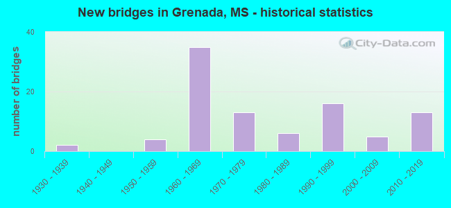
- New bridges - historical statistics
- 21930-1939
- 41950-1959
- 351960-1969
- 131970-1979
- 61980-1989
- 161990-1999
- 52000-2009
- 132010-2019


- Bridge Condition - Deck
- 22.4%Very good
- 34.3%Good
- 40.3%Satisfactory
- 1.5%Fair
- 1.5%Serious

- Bridge Condition - Superstructure
- 31.3%Very good
- 47.8%Good
- 13.4%Satisfactory
- 7.5%Fair

- Bridge Condition - Substructure
- 28.4%Very good
- 52.2%Good
- 16.4%Satisfactory
- 1.5%Fair
- 1.5%Serious

- Bridge Condition - Channel
- 1.5%Excellent
- 25.8%Very good
- 40.9%Good
- 21.2%Satisfactory
- 7.6%Fair
- 3.0%Poor

- Bridge Condition - Culverts
- 84.6%Good
- 15.4%Satisfactory
Find on map >> Show street view
Structure Number: 11000550222014, Location: 4.4 MI S SR 7 (Lat: 33.724436, Lng: -89.830561), Route carried "on" structure: Interstate 55, Year Built: 1965, Status: Open, Structure Length: 2.04m (6.69ft), Average Daily Traffic: 12,000 (year 2020), Truck Traffic: 32%, Average Future Daily Traffic: 15,000 (year 2040), Design Load: HS 20, Features Intersected: PERRY CREEK
Minimum Vertical Clearance: 30+ m (98+ ft), Kilometerpoint: 5.604, Lanes on structure: 4, Base Highway Network: Yes (Inventory Route: 5, Subroute: 1), Owner: State Highway Agency, Approaching Roadway Width: 39.0m (128.0ft), Skew: 4 degrees, Material/Design: Concrete, Design/Construction: Culvert, Number Of Spans In Main Unit: 2, Length of Maximum Span: 6.7m (22.0ft)
Condition: Channel: Good, Culverts: Satisfactory, Operating Rating: 84.6 metric tons, Method Used To Determine Operating Rating: Load Factor (LF), Inventory Rating: 50.4 metric tons, Method Used To Determine Inventory Rating: Load Factor (LF), Structural Evaluation: Equal to present minimum criteria, Waterway Adequacy: Equal to present desirable criteria, Approach Roadway Alignment: Equal to present desirable criteria, Length Of Structure Improvement: 2.44m (8.01ft), Designated Inspection Frequency: Every 24 months, Inspection Date: November 2021, Bridge Improvement Cost: $130,000,000, Roadway Improvement Cost: $200,000,000, Total Project Cost: $396,000,000
Find on map >> Show street view
Structure Number: 11000550222015, Location: 4.3 MI S SR 7 (Lat: 33.726506, Lng: -89.831133), Route carried "on" structure: Interstate 55, Year Built: 1965, Status: Open, Structure Length: 1.43m (4.69ft), Average Daily Traffic: 12,000 (year 2020), Truck Traffic: 32%, Average Future Daily Traffic: 15,000 (year 2040), Design Load: HS 20, Features Intersected: STREAM
Minimum Vertical Clearance: 30+ m (98+ ft), Kilometerpoint: 5.839, Lanes on structure: 4, Base Highway Network: Yes (Inventory Route: 5, Subroute: 1), Owner: State Highway Agency, Approaching Roadway Width: 39.0m (128.0ft), Skew: 3 degrees, Material/Design: Concrete, Design/Construction: Culvert, Number Of Spans In Main Unit: 2, Length of Maximum Span: 5.5m (18.0ft)
Condition: Channel: Satisfactory, Culverts: Good, Structural Evaluation: Better than present minimum criteria, Waterway Adequacy: Equal to present desirable criteria, Approach Roadway Alignment: Equal to present desirable criteria, Length Of Structure Improvement: 1.83m (6.00ft), Designated Inspection Frequency: Every 24 months, Inspection Date: November 2021, Bridge Improvement Cost: $98,000,000, Roadway Improvement Cost: $200,000,000, Total Project Cost: $357,000,000
Find on map >> Show street view
Structure Number: 11000550222016A, Location: 4.2 MI S SR 7 (Lat: 33.727744, Lng: -89.831783), Route carried "on" structure: Interstate 55, Year Built: 1964, Year Reconstructed: 1991, Status: Open, Structure Length: 6.55m (21.49ft), Average Daily Traffic: 6,000 (year 2020), Truck Traffic: 33%, Average Future Daily Traffic: 7,500 (year 2040), Design Load: HS 20+Mod, Features Intersected: CARROLLTON ROAD
Minimum Vertical Clearance: 30+ m (98+ ft), Kilometerpoint: 19.283, Lanes on structure: 2, Lanes under structure: 2, Base Highway Network: Yes (Inventory Route: 5, Subroute: 1), Owner: State Highway Agency, Approaching Roadway Width: 12.8m (42.0ft), Skew: 4 degrees, Material/Design: Prestressed concrete continuous, Design/Construction: Stringer/Multi-beam, Number Of Spans In Main Unit: 3, Length of Maximum Span: 21.3m (69.9ft), Curb-To-Curb Width: 12.8m (42.0ft), Out-to-Out Width: 13.7m (44.9ft)
Condition: Deck: Satisfactory, Superstructure: Good, Substructure: Good, Operating Rating: 75.6 metric tons, Method Used To Determine Operating Rating: Load Factor (LF), Inventory Rating: 38.4 metric tons, Method Used To Determine Inventory Rating: Load Factor (LF), Structural Evaluation: Better than present minimum criteria, Deck Geometry: Equal to present desirable criteria, Underclear: Equal to present minimum criteria, Approach Roadway Alignment: Equal to present desirable criteria, Designated Inspection Frequency: Every 24 months, Inspection Date: November 2021, Deck Structure Type: Concrete Cast-file-Place
Find on map >> Show street view
Structure Number: 11000550222016B, Location: 4.2 MI S SR 7 (Lat: 33.727494, Lng: -89.831411), Route carried "on" structure: Interstate 55, Year Built: 1964, Year Reconstructed: 1991, Status: Open, Structure Length: 6.58m (21.59ft), Average Daily Traffic: 6,000 (year 2020), Truck Traffic: 32%, Average Future Daily Traffic: 7,500 (year 2040), Design Load: HS 20+Mod, Features Intersected: CARROLLTON ROAD
Minimum Vertical Clearance: 30+ m (98+ ft), Kilometerpoint: 5.951, Lanes on structure: 2, Lanes under structure: 2, Base Highway Network: Yes (Inventory Route: 5, Subroute: 1), Owner: State Highway Agency, Approaching Roadway Width: 12.8m (42.0ft), Skew: 4 degrees, Material/Design: Prestressed concrete continuous, Design/Construction: Stringer/Multi-beam, Number Of Spans In Main Unit: 3, Length of Maximum Span: 21.3m (69.9ft), Curb-To-Curb Width: 12.8m (42.0ft), Out-to-Out Width: 13.7m (44.9ft)
Condition: Deck: Good, Superstructure: Good, Substructure: Good, Operating Rating: 75.6 metric tons, Method Used To Determine Operating Rating: Load Factor (LF), Inventory Rating: 38.4 metric tons, Method Used To Determine Inventory Rating: Load Factor (LF), Structural Evaluation: Better than present minimum criteria, Deck Geometry: Equal to present desirable criteria, Underclear: Superior to present desirable criteria, Approach Roadway Alignment: Equal to present desirable criteria, Designated Inspection Frequency: Every 24 months, Inspection Date: November 2021, Deck Structure Type: Concrete Cast-file-Place
Find on map >> Show street view
Structure Number: 11000550222067A, Location: 0.9 MI N SR 7 (Lat: 33.799692, Lng: -89.840453), Route carried "on" structure: Interstate 55, Year Built: 1965, Status: Open, Structure Length: 11.58m (37.99ft), Average Daily Traffic: 9,500 (year 2020), Truck Traffic: 30%, Average Future Daily Traffic: 11,500 (year 2040), Design Load: HS 20+Mod, Features Intersected: YALOBUSHA RIVER
Minimum Vertical Clearance: 30+ m (98+ ft), Kilometerpoint: 11.096, Lanes on structure: 2, Base Highway Network: Yes (Inventory Route: 5, Subroute: 1), Owner: State Highway Agency, Approaching Roadway Width: 8.5m (27.9ft), Material/Design: Steel continuous, Design/Construction: Stringer/Multi-beam, Number Of Spans In Main Unit: 3, Number Of Approach Spans: 2, Length of Maximum Span: 36.6m (120.1ft), Curb or Sidewalk Widths: Left: 0.5m (1.6ft), Right: 0.5m (1.6ft), Curb-To-Curb Width: 8.5m (27.9ft), Out-to-Out Width: 9.1m (29.9ft)
Condition: Deck: Satisfactory, Superstructure: Good, Substructure: Good, Channel: Satisfactory, Operating Rating: 51.4 metric tons, Method Used To Determine Operating Rating: Load Factor (LF), Inventory Rating: 30.7 metric tons, Method Used To Determine Inventory Rating: Load Factor (LF), Structural Evaluation: Better than present minimum criteria, Deck Geometry: High priority of corrective action, Waterway Adequacy: Equal to present minimum criteria, Approach Roadway Alignment: Equal to present desirable criteria, Length Of Structure Improvement: 11.58m (37.99ft), Designated Inspection Frequency: Every 24 months, Underwater Inspection Frequency: Every 60 months, Inspection Date: Febuary 2022, Underwater Inspection Date: July 2019, Bridge Improvement Cost: $342,000,000, Roadway Improvement Cost: $26,000,000, Total Project Cost: $368,000,000, Deck Structure Type: Concrete Cast-file-Place
Find on map >> Show street view
Structure Number: 11000550222067B, Location: 0.9 MI N SR 7 (Lat: 33.798508, Lng: -89.839428), Route carried "on" structure: Interstate 55, Year Built: 1965, Status: Open, Structure Length: 11.58m (37.99ft), Average Daily Traffic: 9,500 (year 2020), Truck Traffic: 30%, Average Future Daily Traffic: 11,500 (year 2040), Design Load: HS 20+Mod, Features Intersected: YALOBUSHA RIVER
Minimum Vertical Clearance: 30+ m (98+ ft), Kilometerpoint: 13.977, Lanes on structure: 2, Base Highway Network: Yes (Inventory Route: 5, Subroute: 1), Owner: State Highway Agency, Approaching Roadway Width: 8.5m (27.9ft), Material/Design: Steel continuous, Design/Construction: Stringer/Multi-beam, Number Of Spans In Main Unit: 3, Number Of Approach Spans: 2, Length of Maximum Span: 36.6m (120.1ft), Curb or Sidewalk Widths: Left: 0.5m (1.6ft), Right: 0.5m (1.6ft), Curb-To-Curb Width: 8.5m (27.9ft), Out-to-Out Width: 9.1m (29.9ft)
Condition: Deck: Satisfactory, Superstructure: Good, Substructure: Good, Channel: Satisfactory, Operating Rating: 51.4 metric tons, Method Used To Determine Operating Rating: Load Factor (LF), Inventory Rating: 30.7 metric tons, Method Used To Determine Inventory Rating: Load Factor (LF), Structural Evaluation: Better than present minimum criteria, Deck Geometry: High priority of corrective action, Waterway Adequacy: Equal to present minimum criteria, Approach Roadway Alignment: Equal to present desirable criteria, Length Of Structure Improvement: 11.58m (37.99ft), Designated Inspection Frequency: Every 24 months, Underwater Inspection Frequency: Every 60 months, Inspection Date: Febuary 2020, Underwater Inspection Date: July 2019, Bridge Improvement Cost: $342,000,000, Roadway Improvement Cost: $26,000,000, Total Project Cost: $368,000,000, Deck Structure Type: Concrete Cast-file-Place
Find on map >> Show street view
Structure Number: 11000550222071A, Location: 1.3 MI N SR 7 (Lat: 33.805344, Lng: -89.840464), Route carried "on" structure: Interstate 55, Year Built: 1965, Status: Open, Structure Length: 7.32m (24.02ft), Average Daily Traffic: 9,500 (year 2020), Truck Traffic: 30%, Average Future Daily Traffic: 11,500 (year 2040), Design Load: HS 20+Mod, Features Intersected: YALOBUSHA RIVER RELIEF
Minimum Vertical Clearance: 30+ m (98+ ft), Kilometerpoint: 10.469, Lanes on structure: 2, Base Highway Network: Yes (Inventory Route: 5, Subroute: 1), Owner: State Highway Agency, Approaching Roadway Width: 8.5m (27.9ft), Material/Design: Prestressed concrete, Design/Construction: Stringer/Multi-beam, Number Of Spans In Main Unit: 6, Length of Maximum Span: 12.2m (40.0ft), Curb or Sidewalk Widths: Left: 0.5m (1.6ft), Right: 0.5m (1.6ft), Curb-To-Curb Width: 8.5m (27.9ft), Out-to-Out Width: 9.1m (29.9ft)
Condition: Deck: Satisfactory, Superstructure: Good, Substructure: Good, Channel: Good, Operating Rating: 75.3 metric tons, Method Used To Determine Operating Rating: Load Factor (LF), Inventory Rating: 43.7 metric tons, Method Used To Determine Inventory Rating: Load Factor (LF), Structural Evaluation: Better than present minimum criteria, Deck Geometry: High priority of corrective action, Waterway Adequacy: Equal to present minimum criteria, Approach Roadway Alignment: Equal to present desirable criteria, Length Of Structure Improvement: 7.32m (24.02ft), Designated Inspection Frequency: Every 24 months, Inspection Date: Febuary 2022, Bridge Improvement Cost: $220,000,000, Roadway Improvement Cost: $26,000,000, Total Project Cost: $246,000,000, Deck Structure Type: Concrete Cast-file-Place
Find on map >> Show street view
Structure Number: 11000550222071B, Location: 1.3 MI N SR 7 (Lat: 33.804325, Lng: -89.839186), Route carried "on" structure: Interstate 55, Year Built: 1965, Status: Open, Structure Length: 7.32m (24.02ft), Average Daily Traffic: 9,500 (year 2020), Truck Traffic: 30%, Average Future Daily Traffic: 11,500 (year 2040), Design Load: HS 20+Mod, Features Intersected: YALOBUSHA RIVER RELIEF
Minimum Vertical Clearance: 30+ m (98+ ft), Kilometerpoint: 14.622, Lanes on structure: 2, Base Highway Network: Yes (Inventory Route: 5, Subroute: 1), Owner: State Highway Agency, Approaching Roadway Width: 8.5m (27.9ft), Material/Design: Prestressed concrete, Design/Construction: Stringer/Multi-beam, Number Of Spans In Main Unit: 6, Length of Maximum Span: 12.2m (40.0ft), Curb or Sidewalk Widths: Left: 0.5m (1.6ft), Right: 0.5m (1.6ft), Curb-To-Curb Width: 8.5m (27.9ft), Out-to-Out Width: 9.1m (29.9ft)
Condition: Deck: Good, Superstructure: Good, Substructure: Good, Channel: Good, Operating Rating: 75.3 metric tons, Method Used To Determine Operating Rating: Load Factor (LF), Inventory Rating: 43.7 metric tons, Method Used To Determine Inventory Rating: Load Factor (LF), Structural Evaluation: Better than present minimum criteria, Deck Geometry: High priority of corrective action, Waterway Adequacy: Equal to present minimum criteria, Approach Roadway Alignment: Equal to present desirable criteria, Length Of Structure Improvement: 7.32m (24.02ft), Designated Inspection Frequency: Every 24 months, Inspection Date: Febuary 2020, Bridge Improvement Cost: $220,000,000, Roadway Improvement Cost: $26,000,000, Total Project Cost: $246,000,000, Deck Structure Type: Concrete Cast-file-Place
Find on map >> Show street view
Structure Number: 11000550222079, Location: 2.1 MI N SR 7 (Lat: 33.816019, Lng: -89.839219), Route carried "on" structure: Interstate 55, Year Built: 1965, Status: Open, Structure Length: 1.31m (4.30ft), Average Daily Traffic: 19,000 (year 2020), Truck Traffic: 30%, Average Future Daily Traffic: 23,000 (year 2040), Design Load: HS 20, Features Intersected: MARTINS CREEK
Minimum Vertical Clearance: 30+ m (98+ ft), Kilometerpoint: 15.921, Lanes on structure: 6, Base Highway Network: Yes (Inventory Route: 5, Subroute: 1), Owner: State Highway Agency, Approaching Roadway Width: 39.0m (128.0ft), Skew: 4 degrees, Material/Design: Concrete, Design/Construction: Culvert, Number Of Spans In Main Unit: 2, Length of Maximum Span: 4.3m (14.1ft)
Condition: Channel: Satisfactory, Culverts: Good, Operating Rating: 52.0 metric tons, Method Used To Determine Operating Rating: Load Factor (LF), Inventory Rating: 31.1 metric tons, Method Used To Determine Inventory Rating: Load Factor (LF), Structural Evaluation: Better than present minimum criteria, Waterway Adequacy: Equal to present minimum criteria, Approach Roadway Alignment: Equal to present desirable criteria, Length Of Structure Improvement: 1.83m (6.00ft), Designated Inspection Frequency: Every 24 months, Inspection Date: Febuary 2020, Bridge Improvement Cost: $98,000,000, Roadway Improvement Cost: $200,000,000, Total Project Cost: $357,000,000
Find on map >> Show street view
Structure Number: 11000550222084A, Location: I 55 OVER US 51 (Lat: 33.823778, Lng: -89.839181), Route carried "on" structure: Interstate 55, Year Built: 1965, Status: Open, Structure Length: 5.64m (18.50ft), Average Daily Traffic: 8,000 (year 2020), Truck Traffic: 26%, Average Future Daily Traffic: 10,000 (year 2040), Design Load: HS 20+Mod, Features Intersected: US 51
Minimum Vertical Clearance: 30+ m (98+ ft), Kilometerpoint: 8.418, Lanes on structure: 2, Lanes under structure: 2, Base Highway Network: Yes (Inventory Route: 5, Subroute: 1), Owner: State Highway Agency, Approaching Roadway Width: 8.5m (27.9ft), Skew: 4 degrees, Material/Design: Prestressed concrete, Design/Construction: Stringer/Multi-beam, Number Of Spans In Main Unit: 3, Length of Maximum Span: 18.3m (60.0ft), Curb or Sidewalk Widths: Left: 0.5m (1.6ft), Right: 0.5m (1.6ft), Curb-To-Curb Width: 8.5m (27.9ft), Out-to-Out Width: 9.1m (29.9ft)
Condition: Deck: Satisfactory, Superstructure: Satisfactory, Substructure: Good, Operating Rating: 71.0 metric tons, Method Used To Determine Operating Rating: Load Factor (LF), Inventory Rating: 42.5 metric tons, Method Used To Determine Inventory Rating: Load Factor (LF), Structural Evaluation: Equal to present minimum criteria, Deck Geometry: High priority of replacement, Underclear: Meets minimum limits, Approach Roadway Alignment: Equal to present desirable criteria, Length Of Structure Improvement: 5.64m (18.50ft), Designated Inspection Frequency: Every 24 months, Inspection Date: March 2020, Bridge Improvement Cost: $167,000,000, Roadway Improvement Cost: $26,000,000, Total Project Cost: $193,000,000, Deck Structure Type: Concrete Cast-file-Place
Find on map >> Show street view
Structure Number: 11000550222084B, Location: I 55 OVER US 51 (Lat: 33.823056, Lng: -89.838919), Route carried "on" structure: Interstate 55, Year Built: 1965, Status: Open, Structure Length: 5.64m (18.50ft), Average Daily Traffic: 8,000 (year 2020), Truck Traffic: 26%, Average Future Daily Traffic: 10,000 (year 2040), Design Load: HS 20+Mod, Features Intersected: US 51
Minimum Vertical Clearance: 30+ m (98+ ft), Kilometerpoint: 16.702, Lanes on structure: 2, Lanes under structure: 2, Base Highway Network: Yes (Inventory Route: 5, Subroute: 1), Owner: State Highway Agency, Approaching Roadway Width: 8.5m (27.9ft), Skew: 4 degrees, Material/Design: Prestressed concrete, Design/Construction: Stringer/Multi-beam, Number Of Spans In Main Unit: 3, Length of Maximum Span: 18.3m (60.0ft), Curb or Sidewalk Widths: Left: 0.5m (1.6ft), Right: 0.5m (1.6ft), Curb-To-Curb Width: 8.5m (27.9ft), Out-to-Out Width: 9.1m (29.9ft)
Condition: Deck: Satisfactory, Superstructure: Satisfactory, Substructure: Good, Operating Rating: 71.0 metric tons, Method Used To Determine Operating Rating: Load Factor (LF), Inventory Rating: 42.5 metric tons, Method Used To Determine Inventory Rating: Load Factor (LF), Structural Evaluation: Equal to present minimum criteria, Deck Geometry: High priority of replacement, Underclear: Meets minimum limits, Approach Roadway Alignment: Equal to present desirable criteria, Length Of Structure Improvement: 5.64m (18.50ft), Designated Inspection Frequency: Every 24 months, Inspection Date: January 2022, Bridge Improvement Cost: $167,000,000, Roadway Improvement Cost: $26,000,000, Total Project Cost: $193,000,000, Deck Structure Type: Concrete Cast-file-Place
Find on map >> Show street view
Structure Number: 11000550222112A, Location: I 55 OVER SR 7 NORTH (Lat: 33.862767, Lng: -89.842322), Route carried "on" structure: Interstate 55, Year Built: 1960, Status: Open, Structure Length: 4.72m (15.49ft), Average Daily Traffic: 8,000 (year 2020), Truck Traffic: 26%, Average Future Daily Traffic: 10,000 (year 2040), Design Load: HS 20+Mod, Features Intersected: SR 7
Minimum Vertical Clearance: 30+ m (98+ ft), Kilometerpoint: 4.059, Lanes on structure: 2, Lanes under structure: 2, Base Highway Network: Yes (Inventory Route: 5, Subroute: 1), Owner: State Highway Agency, Approaching Roadway Width: 8.5m (27.9ft), Skew: 2 degrees, Material/Design: Prestressed concrete, Design/Construction: Stringer/Multi-beam, Number Of Spans In Main Unit: 3, Length of Maximum Span: 15.5m (50.9ft), Curb or Sidewalk Widths: Left: 0.5m (1.6ft), Right: 0.5m (1.6ft), Curb-To-Curb Width: 8.5m (27.9ft), Out-to-Out Width: 9.1m (29.9ft)
Condition: Deck: Satisfactory, Superstructure: Good, Substructure: Good, Operating Rating: 75.7 metric tons, Method Used To Determine Operating Rating: Load Factor (LF), Inventory Rating: 42.1 metric tons, Method Used To Determine Inventory Rating: Load Factor (LF), Structural Evaluation: Better than present minimum criteria, Deck Geometry: High priority of replacement, Underclear: Somewhat better than minimum adequacy, Approach Roadway Alignment: Equal to present desirable criteria, Length Of Structure Improvement: 12.19m (39.99ft), Designated Inspection Frequency: Every 24 months, Inspection Date: March 2020, Bridge Improvement Cost: $140,000,000, Roadway Improvement Cost: $26,000,000, Total Project Cost: $166,000,000, Deck Structure Type: Concrete Cast-file-Place
Find on map >> Show street view
Structure Number: 11000550222112B, Location: I 55 OVER SR 7 NORTH (Lat: 33.862500, Lng: -89.841942), Route carried "on" structure: Interstate 55, Year Built: 1960, Status: Open, Structure Length: 4.72m (15.49ft), Average Daily Traffic: 8,000 (year 2020), Truck Traffic: 26%, Average Future Daily Traffic: 10,000 (year 2040), Design Load: HS 20+Mod, Features Intersected: SR 7
Minimum Vertical Clearance: 30+ m (98+ ft), Kilometerpoint: 21.113, Lanes on structure: 2, Lanes under structure: 2, Base Highway Network: Yes (Inventory Route: 5, Subroute: 1), Owner: State Highway Agency, Approaching Roadway Width: 8.5m (27.9ft), Skew: 2 degrees, Material/Design: Prestressed concrete, Design/Construction: Stringer/Multi-beam, Number Of Spans In Main Unit: 3, Length of Maximum Span: 15.5m (50.9ft), Curb or Sidewalk Widths: Left: 0.5m (1.6ft), Right: 0.5m (1.6ft), Curb-To-Curb Width: 8.5m (27.9ft), Out-to-Out Width: 9.1m (29.9ft)
Condition: Deck: Satisfactory, Superstructure: Good, Substructure: Good, Operating Rating: 75.7 metric tons, Method Used To Determine Operating Rating: Load Factor (LF), Inventory Rating: 42.1 metric tons, Method Used To Determine Inventory Rating: Load Factor (LF), Structural Evaluation: Better than present minimum criteria, Deck Geometry: High priority of replacement, Underclear: Meets minimum limits, Approach Roadway Alignment: Equal to present desirable criteria, Length Of Structure Improvement: 4.72m (15.49ft), Designated Inspection Frequency: Every 24 months, Inspection Date: January 2022, Bridge Improvement Cost: $140,000,000, Roadway Improvement Cost: $26,000,000, Total Project Cost: $166,000,000, Deck Structure Type: Concrete Cast-file-Place
Find on map >> Show street view
Structure Number: 21000510222054, Location: 3.8 MI N MONTGOMERY CL (Lat: 33.721422, Lng: -89.781236), Route carried "on" structure: US 51, Year Built: 1934, Status: Temporarily open, Structure Length: 4.05m (13.29ft), Average Daily Traffic: 5,300 (year 2020), Truck Traffic: 7%, Average Future Daily Traffic: 5,400 (year 2040), Design Load: H 15, Features Intersected: JACKSON CREEK
Minimum Vertical Clearance: 30+ m (98+ ft), Kilometerpoint: 5.943, Lanes on structure: 2, Base Highway Network: Yes (Inventory Route: 5, Subroute: 1), Owner: State Highway Agency, Approaching Roadway Width: 7.3m (24.0ft), Skew: 3 degrees, Material/Design: Steel, Design/Construction: Stringer/Multi-beam, Number Of Spans In Main Unit: 7, Length of Maximum Span: 5.8m (19.0ft), Curb or Sidewalk Widths: Left: 0.2m (0.7ft), Right: 0.2m (0.7ft), Curb-To-Curb Width: 7.3m (24.0ft), Out-to-Out Width: 8.2m (26.9ft)
Condition: Deck: Fair, Superstructure: Fair, Substructure: Serious, Channel: Satisfactory, Structural Evaluation: High priority of replacement, Deck Geometry: High priority of replacement, Waterway Adequacy: Equal to present minimum criteria, Approach Roadway Alignment: Equal to present desirable criteria, Length Of Structure Improvement: 5.25m (17.22ft), Designated Inspection Frequency: Every 24 months, Inspection Date: May 2020, Bridge Improvement Cost: $450,000,000, Roadway Improvement Cost: $45,000,000, Total Project Cost: $999,999,000, Deck Structure Type: Concrete Cast-file-Place, Wearing Surface/Protective System: Wearing Surface: Bituminous
Find on map >> Show street view
Structure Number: 21000510222073, Location: 5.7 MI N MONTGOMERY CL (Lat: 33.742728, Lng: -89.801100), Route carried "on" structure: US 51, Year Built: 1994, Status: Open, Structure Length: 7.35m (24.11ft), Average Daily Traffic: 5,300 (year 2020), Truck Traffic: 7%, Average Future Daily Traffic: 5,400 (year 2040), Design Load: HS 20, Features Intersected: PERRY CREEK
Minimum Vertical Clearance: 30+ m (98+ ft), Kilometerpoint: 8.975, Lanes on structure: 5, Base Highway Network: Yes (Inventory Route: 5, Subroute: 1), Owner: State Highway Agency, Approaching Roadway Width: 24.4m (80.1ft), Material/Design: Prestressed concrete continuous, Design/Construction: Stringer/Multi-beam, Number Of Spans In Main Unit: 6, Length of Maximum Span: 12.2m (40.0ft), Curb-To-Curb Width: 24.4m (80.1ft), Out-to-Out Width: 25.2m (82.7ft)
Condition: Deck: Good, Superstructure: Fair, Substructure: Good, Channel: Good, Operating Rating: 44.1 metric tons, Method Used To Determine Operating Rating: Load Factor (LF), Inventory Rating: 38.8 metric tons, Method Used To Determine Inventory Rating: Load Factor (LF), Structural Evaluation: Somewhat better than minimum adequacy, Deck Geometry: Superior to present desirable criteria, Waterway Adequacy: Equal to present desirable criteria, Approach Roadway Alignment: Equal to present desirable criteria, Designated Inspection Frequency: Every 24 months, Inspection Date: June 2020, Deck Structure Type: Concrete Cast-file-Place
Find on map >> Show street view
Structure Number: 21000510222088, Location: 0.5 MI S SR 8 (Lat: 33.763436, Lng: -89.808928), Route carried "on" structure: US 51, Year Built: 1973, Status: Open, Structure Length: 0.98m (3.22ft), Average Daily Traffic: 15,000 (year 2020), Truck Traffic: 4%, Average Future Daily Traffic: 15,000 (year 2040), Design Load: HS 20, Features Intersected: BROWN CREEK
Minimum Vertical Clearance: 30+ m (98+ ft), Kilometerpoint: 11.407, Lanes on structure: 5, Base Highway Network: Yes (Inventory Route: 5, Subroute: 1), Owner: State Highway Agency, Approaching Roadway Width: 22.9m (75.1ft), Skew: 1 degrees, Material/Design: Concrete, Design/Construction: Culvert, Number Of Spans In Main Unit: 2, Length of Maximum Span: 4.3m (14.1ft)
Condition: Channel: Good, Culverts: Good, Operating Rating: 56.8 metric tons, Method Used To Determine Operating Rating: Load Factor (LF), Inventory Rating: 34.0 metric tons, Method Used To Determine Inventory Rating: Load Factor (LF), Structural Evaluation: Better than present minimum criteria, Waterway Adequacy: Equal to present minimum criteria, Approach Roadway Alignment: Equal to present desirable criteria, Length Of Structure Improvement: 0.98m (3.22ft), Designated Inspection Frequency: Every 24 months, Inspection Date: June 2020, Bridge Improvement Cost: $72,000,000, Roadway Improvement Cost: $200,000,000, Total Project Cost: $316,000,000
Find on map >> Show street view
Structure Number: 21000510222105, Location: 1.3 MI N SR 8 (Lat: 33.787606, Lng: -89.809861), Route carried "on" structure: US 51, Year Built: 2007, Status: Open, Structure Length: 18.76m (61.55ft), Average Daily Traffic: 8,500 (year 2020), Truck Traffic: 7%, Average Future Daily Traffic: 8,800 (year 2040), Design Load: HS 20, Features Intersected: YALOBUSHA RIVER
Minimum Vertical Clearance: 30+ m (98+ ft), Kilometerpoint: 14.096, Lanes on structure: 4, Base Highway Network: Yes (Inventory Route: 5, Subroute: 1), Owner: State Highway Agency, Approaching Roadway Width: 24.4m (80.1ft), Material/Design: Steel continuous, Design/Construction: Stringer/Multi-beam, Number Of Spans In Main Unit: 3, Number Of Approach Spans: 2, Length of Maximum Span: 65.5m (214.9ft), Curb-To-Curb Width: 24.4m (80.1ft), Out-to-Out Width: 25.2m (82.7ft)
Condition: Deck: Very good, Superstructure: Very good, Substructure: Very good, Channel: Satisfactory, Operating Rating: 48.2 metric tons, Method Used To Determine Operating Rating: Load Factor (LF), Inventory Rating: 38.2 metric tons, Method Used To Determine Inventory Rating: Load Factor (LF), Structural Evaluation: Equal to present desirable criteria, Deck Geometry: Superior to present desirable criteria, Waterway Adequacy: Equal to present desirable criteria, Approach Roadway Alignment: Equal to present desirable criteria, Designated Inspection Frequency: Every 24 months, Inspection Date: May 2021, Deck Structure Type: Concrete Cast-file-Place
Find on map >> Show street view
Structure Number: 21000510222112A, Location: AT JCT SR 332 (Lat: 33.797939, Lng: -89.811244), Route carried "on" structure: US 51, Year Built: 2013, Status: Open, Structure Length: 9.80m (32.15ft), Average Daily Traffic: 4,250 (year 2020), Truck Traffic: 8%, Average Future Daily Traffic: 4,400 (year 2040), Design Load: HS 20, Features Intersected: YALOBUSHA RIVER RELIEF
Minimum Vertical Clearance: 30+ m (98+ ft), Kilometerpoint: 2.643, Lanes on structure: 2, Base Highway Network: Yes (Inventory Route: 5, Subroute: 1), Owner: State Highway Agency, Approaching Roadway Width: 12.2m (40.0ft), Material/Design: Prestressed concrete continuous, Design/Construction: Stringer/Multi-beam, Number Of Spans In Main Unit: 8, Length of Maximum Span: 12.2m (40.0ft), Curb-To-Curb Width: 12.2m (40.0ft), Out-to-Out Width: 13.0m (42.7ft)
Condition: Deck: Good, Superstructure: Very good, Substructure: Good, Channel: Very good, Operating Rating: 39.3 metric tons, Method Used To Determine Operating Rating: Load Factor (LF), Inventory Rating: 37.0 metric tons, Method Used To Determine Inventory Rating: Load Factor (LF), Structural Evaluation: Better than present minimum criteria, Deck Geometry: Better than present minimum criteria, Waterway Adequacy: Equal to present desirable criteria, Approach Roadway Alignment: Equal to present desirable criteria, Designated Inspection Frequency: Every 24 months, Inspection Date: November 2021, Deck Structure Type: Concrete Cast-file-Place
Find on map >> Show street view
Structure Number: 21000510222112B, Location: AT JCT SR 332 (Lat: 33.797081, Lng: -89.810944), Route carried "on" structure: US 51, Year Built: 2013, Status: Open, Structure Length: 9.80m (32.15ft), Average Daily Traffic: 4,250 (year 2020), Truck Traffic: 7%, Average Future Daily Traffic: 4,400 (year 2040), Design Load: HS 20, Features Intersected: YALOBUSHA RIVER RELIEF
Minimum Vertical Clearance: 30+ m (98+ ft), Kilometerpoint: 15.155, Lanes on structure: 2, Base Highway Network: Yes (Inventory Route: 5, Subroute: 1), Owner: State Highway Agency, Approaching Roadway Width: 12.2m (40.0ft), Material/Design: Prestressed concrete continuous, Design/Construction: Stringer/Multi-beam, Number Of Spans In Main Unit: 8, Length of Maximum Span: 12.2m (40.0ft), Curb-To-Curb Width: 12.2m (40.0ft), Out-to-Out Width: 13.0m (42.7ft)
Condition: Deck: Very good, Superstructure: Very good, Substructure: Very good, Channel: Very good, Operating Rating: 39.3 metric tons, Method Used To Determine Operating Rating: Load Factor (LF), Inventory Rating: 37.0 metric tons, Method Used To Determine Inventory Rating: Load Factor (LF), Structural Evaluation: Equal to present desirable criteria, Deck Geometry: Better than present minimum criteria, Waterway Adequacy: Equal to present desirable criteria, Approach Roadway Alignment: Equal to present desirable criteria, Designated Inspection Frequency: Every 24 months, Inspection Date: November 2021, Deck Structure Type: Concrete Cast-file-Place
Find on map >> Show street view
Structure Number: 21000510222114A, Location: 0.1 MI N SR 332 (Lat: 33.800753, Lng: -89.812492), Route carried "on" structure: US 51, Year Built: 2013, Status: Open, Structure Length: 8.58m (28.15ft), Average Daily Traffic: 2,650 (year 2020), Truck Traffic: 9%, Average Future Daily Traffic: 2,750 (year 2040), Design Load: HS 20, Features Intersected: RIVERDALE CREEK
Minimum Vertical Clearance: 30+ m (98+ ft), Kilometerpoint: 2.305, Lanes on structure: 2, Base Highway Network: Yes (Inventory Route: 5, Subroute: 1), Owner: State Highway Agency, Approaching Roadway Width: 12.2m (40.0ft), Material/Design: Prestressed concrete, Design/Construction: Stringer/Multi-beam, Number Of Spans In Main Unit: 7, Length of Maximum Span: 12.2m (40.0ft), Curb-To-Curb Width: 12.2m (40.0ft), Out-to-Out Width: 13.0m (42.7ft)
Condition: Deck: Very good, Superstructure: Very good, Substructure: Very good, Channel: Very good, Operating Rating: 39.9 metric tons, Method Used To Determine Operating Rating: Load Factor (LF), Inventory Rating: 37.4 metric tons, Method Used To Determine Inventory Rating: Load Factor (LF), Structural Evaluation: Equal to present desirable criteria, Deck Geometry: Better than present minimum criteria, Waterway Adequacy: Equal to present desirable criteria, Approach Roadway Alignment: Equal to present desirable criteria, Designated Inspection Frequency: Every 24 months, Inspection Date: November 2021, Deck Structure Type: Concrete Cast-file-Place
Find on map >> Show street view
Structure Number: 21000510222114B, Location: 0.1 MI N SR 332 (Lat: 33.800156, Lng: -89.811872), Route carried "on" structure: US 51, Year Built: 2013, Status: Open, Structure Length: 8.59m (28.18ft), Average Daily Traffic: 2,650 (year 2020), Truck Traffic: 9%, Average Future Daily Traffic: 2,750 (year 2040), Design Load: HS 20, Features Intersected: RIVERDALE CREEK
Minimum Vertical Clearance: 30+ m (98+ ft), Kilometerpoint: 15.509, Lanes on structure: 2, Base Highway Network: Yes (Inventory Route: 5, Subroute: 1), Owner: State Highway Agency, Approaching Roadway Width: 12.2m (40.0ft), Material/Design: Prestressed concrete, Design/Construction: Stringer/Multi-beam, Number Of Spans In Main Unit: 1, Number Of Approach Spans: 4, Length of Maximum Span: 24.4m (80.1ft), Curb-To-Curb Width: 12.2m (40.0ft), Out-to-Out Width: 13.0m (42.7ft)
Condition: Deck: Very good, Superstructure: Very good, Substructure: Very good, Channel: Very good, Operating Rating: 36.7 metric tons, Method Used To Determine Operating Rating: Load Factor (LF), Inventory Rating: 35.3 metric tons, Method Used To Determine Inventory Rating: Load Factor (LF), Structural Evaluation: Equal to present desirable criteria, Deck Geometry: Better than present minimum criteria, Waterway Adequacy: Equal to present desirable criteria, Approach Roadway Alignment: Equal to present desirable criteria, Designated Inspection Frequency: Every 24 months, Inspection Date: November 2021, Deck Structure Type: Concrete Cast-file-Place
Find on map >> Show street view
Structure Number: 21000510222118A, Location: 0.5 MI N SR 332 (Lat: 33.804686, Lng: -89.816942), Route carried "on" structure: US 51, Year Built: 2013, Status: Open, Structure Length: 6.14m (20.14ft), Average Daily Traffic: 2,650 (year 2020), Truck Traffic: 9%, Average Future Daily Traffic: 2,750 (year 2040), Design Load: HS 20, Features Intersected: YALOBUSHA RIVER RELIEF
Minimum Vertical Clearance: 30+ m (98+ ft), Kilometerpoint: 1.704, Lanes on structure: 2, Base Highway Network: Yes (Inventory Route: 5, Subroute: 1), Owner: State Highway Agency, Approaching Roadway Width: 12.2m (40.0ft), Material/Design: Prestressed concrete continuous, Design/Construction: Stringer/Multi-beam, Number Of Spans In Main Unit: 5, Length of Maximum Span: 12.2m (40.0ft), Curb-To-Curb Width: 12.2m (40.0ft), Out-to-Out Width: 13.0m (42.7ft)
Condition: Deck: Very good, Superstructure: Very good, Substructure: Very good, Channel: Very good, Operating Rating: 39.1 metric tons, Method Used To Determine Operating Rating: Load Factor (LF), Inventory Rating: 36.9 metric tons, Method Used To Determine Inventory Rating: Load Factor (LF), Structural Evaluation: Equal to present desirable criteria, Deck Geometry: Better than present minimum criteria, Waterway Adequacy: Equal to present desirable criteria, Approach Roadway Alignment: Equal to present desirable criteria, Designated Inspection Frequency: Every 24 months, Inspection Date: November 2021, Deck Structure Type: Concrete Cast-file-Place
Find on map >> Show street view
Structure Number: 21000510222118B, Location: 0.5 MI N SR 332 (Lat: 33.804378, Lng: -89.816372), Route carried "on" structure: US 51, Year Built: 2013, Status: Open, Structure Length: 6.14m (20.14ft), Average Daily Traffic: 2,650 (year 2020), Truck Traffic: 9%, Average Future Daily Traffic: 2,750 (year 2040), Design Load: HS 20, Features Intersected: YALOBUSHA RIVER RELIEF
Minimum Vertical Clearance: 30+ m (98+ ft), Kilometerpoint: 16.139, Lanes on structure: 2, Base Highway Network: Yes (Inventory Route: 5, Subroute: 1), Owner: State Highway Agency, Approaching Roadway Width: 12.2m (40.0ft), Material/Design: Prestressed concrete continuous, Design/Construction: Stringer/Multi-beam, Number Of Spans In Main Unit: 5, Length of Maximum Span: 12.2m (40.0ft), Curb-To-Curb Width: 12.2m (40.0ft), Out-to-Out Width: 13.0m (42.7ft)
Condition: Deck: Good, Superstructure: Very good, Substructure: Good, Channel: Very good, Operating Rating: 39.1 metric tons, Method Used To Determine Operating Rating: Load Factor (LF), Inventory Rating: 36.9 metric tons, Method Used To Determine Inventory Rating: Load Factor (LF), Structural Evaluation: Better than present minimum criteria, Deck Geometry: Better than present minimum criteria, Waterway Adequacy: Equal to present desirable criteria, Approach Roadway Alignment: Equal to present desirable criteria, Designated Inspection Frequency: Every 24 months, Inspection Date: November 2021, Deck Structure Type: Concrete Cast-file-Place
Find on map >> Show street view
Structure Number: 21000510222121A, Location: 0.8 MI N SR 332 (Lat: 33.807692, Lng: -89.820506), Route carried "on" structure: US 51, Year Built: 2013, Status: Open, Structure Length: 4.93m (16.17ft), Average Daily Traffic: 2,650 (year 2020), Truck Traffic: 9%, Average Future Daily Traffic: 2,750 (year 2040), Design Load: HS 20, Features Intersected: YALOBUSHA RIVER RELIEF
Minimum Vertical Clearance: 30+ m (98+ ft), Kilometerpoint: 1.234, Lanes on structure: 2, Base Highway Network: Yes (Inventory Route: 5, Subroute: 1), Owner: State Highway Agency, Approaching Roadway Width: 12.2m (40.0ft), Material/Design: Prestressed concrete continuous, Design/Construction: Stringer/Multi-beam, Number Of Spans In Main Unit: 4, Length of Maximum Span: 12.2m (40.0ft), Curb-To-Curb Width: 12.2m (40.0ft), Out-to-Out Width: 13.0m (42.7ft)
Condition: Deck: Very good, Superstructure: Very good, Substructure: Very good, Channel: Very good, Operating Rating: 39.1 metric tons, Method Used To Determine Operating Rating: Load Factor (LF), Inventory Rating: 36.9 metric tons, Method Used To Determine Inventory Rating: Load Factor (LF), Structural Evaluation: Equal to present desirable criteria, Deck Geometry: Better than present minimum criteria, Waterway Adequacy: Equal to present desirable criteria, Approach Roadway Alignment: Equal to present desirable criteria, Designated Inspection Frequency: Every 24 months, Inspection Date: November 2021, Deck Structure Type: Concrete Cast-file-Place
Find on map >> Show street view
Structure Number: 21000510222121B, Location: 0.8 MI N SR 332 (Lat: 33.807464, Lng: -89.820025), Route carried "on" structure: US 51, Year Built: 2013, Status: Open, Structure Length: 4.93m (16.17ft), Average Daily Traffic: 2,650 (year 2020), Truck Traffic: 9%, Average Future Daily Traffic: 2,750 (year 2040), Design Load: HS 20, Features Intersected: YALOBUSHA RIVER RELIEF
Minimum Vertical Clearance: 30+ m (98+ ft), Kilometerpoint: 16.620, Lanes on structure: 2, Base Highway Network: Yes (Inventory Route: 5, Subroute: 1), Owner: State Highway Agency, Approaching Roadway Width: 12.2m (40.0ft), Material/Design: Prestressed concrete continuous, Design/Construction: Stringer/Multi-beam, Number Of Spans In Main Unit: 4, Length of Maximum Span: 12.2m (40.0ft), Curb-To-Curb Width: 12.2m (40.0ft), Out-to-Out Width: 13.0m (42.7ft)
Condition: Deck: Very good, Superstructure: Good, Substructure: Very good, Channel: Very good, Operating Rating: 39.1 metric tons, Method Used To Determine Operating Rating: Load Factor (LF), Inventory Rating: 36.9 metric tons, Method Used To Determine Inventory Rating: Load Factor (LF), Structural Evaluation: Better than present minimum criteria, Deck Geometry: Better than present minimum criteria, Waterway Adequacy: Equal to present desirable criteria, Approach Roadway Alignment: Equal to present desirable criteria, Designated Inspection Frequency: Every 24 months, Inspection Date: November 2021, Deck Structure Type: Concrete Cast-file-Place
Find on map >> Show street view
Structure Number: 21000510222122A, Location: 0.9 MI N SR 332 (Lat: 33.808400, Lng: -89.821333), Route carried "on" structure: US 51, Year Built: 2013, Status: Open, Structure Length: 3.71m (12.17ft), Average Daily Traffic: 2,650 (year 2020), Truck Traffic: 9%, Average Future Daily Traffic: 2,750 (year 2040), Design Load: HS 20, Features Intersected: DEMENT CREEK
Minimum Vertical Clearance: 30+ m (98+ ft), Kilometerpoint: 1.125, Lanes on structure: 2, Base Highway Network: Yes (Inventory Route: 5, Subroute: 1), Owner: State Highway Agency, Approaching Roadway Width: 12.2m (40.0ft), Material/Design: Prestressed concrete continuous, Design/Construction: Stringer/Multi-beam, Number Of Spans In Main Unit: 3, Length of Maximum Span: 12.2m (40.0ft), Curb-To-Curb Width: 12.2m (40.0ft), Out-to-Out Width: 13.0m (42.7ft)
Condition: Deck: Very good, Superstructure: Very good, Substructure: Very good, Channel: Very good, Operating Rating: 39.1 metric tons, Method Used To Determine Operating Rating: Load Factor (LF), Inventory Rating: 36.9 metric tons, Method Used To Determine Inventory Rating: Load Factor (LF), Structural Evaluation: Equal to present desirable criteria, Deck Geometry: Better than present minimum criteria, Waterway Adequacy: Equal to present desirable criteria, Approach Roadway Alignment: Equal to present desirable criteria, Designated Inspection Frequency: Every 24 months, Inspection Date: November 2021, Deck Structure Type: Concrete Cast-file-Place
Find on map >> Show street view
Structure Number: 21000510222122B, Location: 0.9 MI N SR 332 (Lat: 33.808250, Lng: -89.820950), Route carried "on" structure: US 51, Year Built: 2013, Status: Open, Structure Length: 3.71m (12.17ft), Average Daily Traffic: 2,650 (year 2020), Truck Traffic: 9%, Average Future Daily Traffic: 2,750 (year 2040), Design Load: HS 20, Features Intersected: DEMENT CREEK
Minimum Vertical Clearance: 30+ m (98+ ft), Kilometerpoint: 16.742, Lanes on structure: 2, Base Highway Network: Yes (Inventory Route: 5, Subroute: 1), Owner: State Highway Agency, Approaching Roadway Width: 12.2m (40.0ft), Material/Design: Prestressed concrete continuous, Design/Construction: Stringer/Multi-beam, Number Of Spans In Main Unit: 3, Length of Maximum Span: 12.2m (40.0ft), Curb-To-Curb Width: 12.2m (40.0ft), Out-to-Out Width: 13.0m (42.7ft)
Condition: Deck: Very good, Superstructure: Good, Substructure: Very good, Channel: Very good, Operating Rating: 39.1 metric tons, Method Used To Determine Operating Rating: Load Factor (LF), Inventory Rating: 36.9 metric tons, Method Used To Determine Inventory Rating: Load Factor (LF), Structural Evaluation: Better than present minimum criteria, Deck Geometry: Better than present minimum criteria, Waterway Adequacy: Equal to present desirable criteria, Approach Roadway Alignment: Equal to present desirable criteria, Designated Inspection Frequency: Every 24 months, Inspection Date: November 2021, Deck Structure Type: Concrete Cast-file-Place
Find on map >> Show street view
Structure Number: 21000510222126A, Location: 1.3 MI N SR 332 (Lat: 33.812811, Lng: -89.826553), Route carried "on" structure: US 51, Year Built: 2013, Status: Open, Structure Length: 4.93m (16.17ft), Average Daily Traffic: 2,650 (year 2020), Truck Traffic: 9%, Average Future Daily Traffic: 2,750 (year 2040), Design Load: HS 20, Features Intersected: YALOBUSHA RIVER RELIEF
Minimum Vertical Clearance: 30+ m (98+ ft), Kilometerpoint: 0.438, Lanes on structure: 2, Base Highway Network: Yes (Inventory Route: 5, Subroute: 1), Owner: State Highway Agency, Approaching Roadway Width: 12.2m (40.0ft), Material/Design: Prestressed concrete continuous, Design/Construction: Stringer/Multi-beam, Number Of Spans In Main Unit: 4, Length of Maximum Span: 12.2m (40.0ft), Curb-To-Curb Width: 12.2m (40.0ft), Out-to-Out Width: 13.0m (42.7ft)
Condition: Deck: Very good, Superstructure: Very good, Substructure: Very good, Channel: Very good, Operating Rating: 39.1 metric tons, Method Used To Determine Operating Rating: Load Factor (LF), Inventory Rating: 36.9 metric tons, Method Used To Determine Inventory Rating: Load Factor (LF), Structural Evaluation: Equal to present desirable criteria, Deck Geometry: Better than present minimum criteria, Waterway Adequacy: Equal to present desirable criteria, Approach Roadway Alignment: Equal to present desirable criteria, Designated Inspection Frequency: Every 24 months, Inspection Date: November 2021, Deck Structure Type: Concrete Cast-file-Place
Find on map >> Show street view
Structure Number: 21000510222126B, Location: 1.3 MI N SR 332 (Lat: 33.812586, Lng: -89.826064), Route carried "on" structure: US 51, Year Built: 2013, Status: Open, Structure Length: 4.93m (16.17ft), Average Daily Traffic: 2,650 (year 2020), Truck Traffic: 9%, Average Future Daily Traffic: 2,750 (year 2040), Design Load: HS 20, Features Intersected: YALOBUSHA RIVER RELIEF
Minimum Vertical Clearance: 30+ m (98+ ft), Kilometerpoint: 17.418, Lanes on structure: 2, Base Highway Network: Yes (Inventory Route: 5, Subroute: 1), Owner: State Highway Agency, Approaching Roadway Width: 12.2m (40.0ft), Material/Design: Prestressed concrete continuous, Design/Construction: Stringer/Multi-beam, Number Of Spans In Main Unit: 4, Length of Maximum Span: 12.2m (40.0ft), Curb-To-Curb Width: 12.2m (40.0ft), Out-to-Out Width: 13.0m (42.7ft)
Condition: Deck: Very good, Superstructure: Good, Substructure: Very good, Channel: Very good, Operating Rating: 39.1 metric tons, Method Used To Determine Operating Rating: Load Factor (LF), Inventory Rating: 36.9 metric tons, Method Used To Determine Inventory Rating: Load Factor (LF), Structural Evaluation: Better than present minimum criteria, Deck Geometry: Better than present minimum criteria, Waterway Adequacy: Equal to present desirable criteria, Approach Roadway Alignment: Equal to present desirable criteria, Designated Inspection Frequency: Every 24 months, Inspection Date: November 2021, Deck Structure Type: Concrete Cast-file-Place
Find on map >> Show street view
Structure Number: 21000510222133A, Location: 2.0 MI N SR 332 (Lat: 33.819972, Lng: -89.834900), Route carried "on" structure: US 51, Year Built: 2013, Status: Open, Structure Length: 3.71m (12.17ft), Average Daily Traffic: 5,300 (year 2020), Truck Traffic: 9%, Average Future Daily Traffic: 5,500 (year 2040), Design Load: HS 20, Features Intersected: MARTIN CREEK
Minimum Vertical Clearance: 30+ m (98+ ft), Kilometerpoint: 18.578, Lanes on structure: 2, Base Highway Network: Yes (Inventory Route: 5, Subroute: 1), Owner: State Highway Agency, Approaching Roadway Width: 12.2m (40.0ft), Skew: 1 degrees, Material/Design: Prestressed concrete continuous, Design/Construction: Stringer/Multi-beam, Number Of Spans In Main Unit: 3, Length of Maximum Span: 12.2m (40.0ft), Curb-To-Curb Width: 12.2m (40.0ft), Out-to-Out Width: 13.0m (42.7ft)
Condition: Deck: Very good, Superstructure: Very good, Substructure: Very good, Channel: Very good, Operating Rating: 68.1 metric tons, Method Used To Determine Operating Rating: Load Factor (LF), Inventory Rating: 40.8 metric tons, Method Used To Determine Inventory Rating: Load Factor (LF), Structural Evaluation: Equal to present desirable criteria, Deck Geometry: Somewhat better than minimum adequacy, Waterway Adequacy: Equal to present desirable criteria, Approach Roadway Alignment: Equal to present desirable criteria, Designated Inspection Frequency: Every 24 months, Inspection Date: November 2021, Deck Structure Type: Concrete Cast-file-Place
Find on map >> Show street view
Structure Number: 31000070220628, Location: 12.4 MI N CARROLL CL (Lat: 33.780267, Lng: -89.910203), Route carried "on" structure: State highway 7, Year Built: 1951, Status: Open, Structure Length: 2.74m (8.99ft), Average Daily Traffic: 7,900 (year 2020), Truck Traffic: 10%, Average Future Daily Traffic: 8,700 (year 2040), Design Load: HS 15, Features Intersected: TURNBULL RELIEF
Minimum Vertical Clearance: 30+ m (98+ ft), Kilometerpoint: 22.193, Lanes on structure: 2, Base Highway Network: Yes (, Subroute: 1), Owner: State Highway Agency, Approaching Roadway Width: 7.9m (25.9ft), Material/Design: Steel, Design/Construction: Stringer/Multi-beam, Number Of Spans In Main Unit: 3, Length of Maximum Span: 9.1m (29.9ft), Curb or Sidewalk Widths: Left: 0.5m (1.6ft), Right: 0.5m (1.6ft), Curb-To-Curb Width: 7.9m (25.9ft), Out-to-Out Width: 8.5m (27.9ft)
Condition: Deck: Satisfactory, Superstructure: Fair, Substructure: Good, Channel: Good, Operating Rating: 40.5 metric tons, Method Used To Determine Operating Rating: Load Factor (LF), Inventory Rating: 24.2 metric tons, Method Used To Determine Inventory Rating: Load Factor (LF), Structural Evaluation: Somewhat better than minimum adequacy, Deck Geometry: High priority of replacement, Waterway Adequacy: Equal to present minimum criteria, Approach Roadway Alignment: Better than present minimum criteria, Length Of Structure Improvement: 4.05m (13.29ft), Designated Inspection Frequency: Every 24 months, Inspection Date: June 2020, Bridge Improvement Cost: $315,000,000, Roadway Improvement Cost: $32,000,000, Total Project Cost: $939,000,000, Deck Structure Type: Concrete Cast-file-Place, Wearing Surface/Protective System: Wearing Surface: Bituminous
Find on map >> Show street view
Structure Number: 31000070220653, Location: 1.7 MI W I 55 (Lat: 33.787589, Lng: -89.868164), Route carried "on" structure: State highway 7, Year Built: 2006, Status: Open, Structure Length: 1.06m (3.48ft), Average Daily Traffic: 7,900 (year 2020), Truck Traffic: 10%, Average Future Daily Traffic: 8,200 (year 2040), Design Load: HS 20, Features Intersected: RELIEF OPENING
Minimum Vertical Clearance: 30+ m (98+ ft), Kilometerpoint: 26.305, Lanes on structure: 5, Base Highway Network: Yes (, Subroute: 1), Owner: State Highway Agency, Approaching Roadway Width: 24.6m (80.7ft), Skew: 2 degrees, Material/Design: Concrete, Design/Construction: Culvert, Number Of Spans In Main Unit: 2, Length of Maximum Span: 4.8m (15.7ft)
Condition: Channel: Good, Culverts: Good, Inventory Rating: 89.9 metric tons, Method Used To Determine Inventory Rating: Load Factor (LF), Structural Evaluation: Better than present minimum criteria, Waterway Adequacy: Equal to present desirable criteria, Approach Roadway Alignment: Equal to present desirable criteria, Designated Inspection Frequency: Every 24 months, Inspection Date: June 2020
Find on map >> Show street view
Structure Number: 31000070220655, Location: 1.5 MI W I 55 (Lat: 33.787597, Lng: -89.865436), Route carried "on" structure: State highway 7, Year Built: 2006, Status: Open, Structure Length: 3.65m (11.98ft), Average Daily Traffic: 7,900 (year 2020), Truck Traffic: 10%, Average Future Daily Traffic: 8,200 (year 2040), Design Load: HS 20, Features Intersected: HOWARD CREEK
Minimum Vertical Clearance: 30+ m (98+ ft), Kilometerpoint: 26.559, Lanes on structure: 5, Base Highway Network: Yes (, Subroute: 1), Owner: State Highway Agency, Approaching Roadway Width: 24.6m (80.7ft), Material/Design: Prestressed concrete continuous, Design/Construction: Stringer/Multi-beam, Number Of Spans In Main Unit: 3, Length of Maximum Span: 12.0m (39.4ft), Curb-To-Curb Width: 24.6m (80.7ft), Out-to-Out Width: 25.5m (83.7ft)
Condition: Deck: Good, Superstructure: Very good, Substructure: Very good, Channel: Excellent, Operating Rating: 58.3 metric tons, Method Used To Determine Operating Rating: Load Factor (LF), Inventory Rating: 34.4 metric tons, Method Used To Determine Inventory Rating: Load Factor (LF), Structural Evaluation: Equal to present desirable criteria, Deck Geometry: Superior to present desirable criteria, Waterway Adequacy: Equal to present desirable criteria, Approach Roadway Alignment: Equal to present desirable criteria, Designated Inspection Frequency: Every 24 months, Inspection Date: June 2020, Deck Structure Type: Concrete Cast-file-Place
Find on map >> Show street view
Structure Number: 31000070220670A, Location: SR 7/SR 8 OVER I 55 (Lat: 33.786039, Lng: -89.840167), Route carried "on" structure: State highway 7, Year Built: 1965, Status: Open, Structure Length: 7.68m (25.20ft), Average Daily Traffic: 3,950 (year 2020), Truck Traffic: 10%, Average Future Daily Traffic: 4,100 (year 2040), Design Load: HS 20, Features Intersected: I 55
Minimum Vertical Clearance: 30+ m (98+ ft), Kilometerpoint: 1.558, Lanes on structure: 2, Lanes under structure: 4, Base Highway Network: Yes (, Subroute: 1), Owner: State Highway Agency, Approaching Roadway Width: 8.5m (27.9ft), Material/Design: Prestressed concrete, Design/Construction: Stringer/Multi-beam, Number Of Spans In Main Unit: 2, Number Of Approach Spans: 2, Length of Maximum Span: 21.3m (69.9ft), Curb or Sidewalk Widths: Left: 0.5m (1.6ft), Right: 0.5m (1.6ft), Curb-To-Curb Width: 8.5m (27.9ft), Out-to-Out Width: 9.1m (29.9ft)
Condition: Deck: Satisfactory, Superstructure: Good, Substructure: Fair, Operating Rating: 85.1 metric tons, Method Used To Determine Operating Rating: Load Factor (LF), Inventory Rating: 49.3 metric tons, Method Used To Determine Inventory Rating: Load Factor (LF), Structural Evaluation: Somewhat better than minimum adequacy, Deck Geometry: High priority of corrective action, Underclear: High priority of corrective action, Approach Roadway Alignment: Equal to present desirable criteria, Length Of Structure Improvement: 7.68m (25.20ft), Designated Inspection Frequency: Every 24 months, Inspection Date: January 2022, Bridge Improvement Cost: $230,000,000, Roadway Improvement Cost: $26,000,000, Total Project Cost: $312,000,000, Deck Structure Type: Concrete Cast-file-Place
Find on map >> Show street view
Structure Number: 31000070220670B, Location: SR 7/SR 8 OVER I 55 (Lat: 33.785911, Lng: -89.841003), Route carried "on" structure: State highway 7, Year Built: 1965, Status: Open, Structure Length: 7.68m (25.20ft), Average Daily Traffic: 3,950 (year 2020), Truck Traffic: 10%, Average Future Daily Traffic: 4,100 (year 2040), Design Load: HS 20, Features Intersected: I 55
Minimum Vertical Clearance: 30+ m (98+ ft), Kilometerpoint: 28.833, Lanes on structure: 2, Lanes under structure: 4, Base Highway Network: Yes (, Subroute: 1), Owner: State Highway Agency, Approaching Roadway Width: 8.5m (27.9ft), Material/Design: Prestressed concrete, Design/Construction: Stringer/Multi-beam, Number Of Spans In Main Unit: 2, Number Of Approach Spans: 2, Length of Maximum Span: 21.3m (69.9ft), Curb or Sidewalk Widths: Left: 0.5m (1.6ft), Right: 0.5m (1.6ft), Curb-To-Curb Width: 8.5m (27.9ft), Out-to-Out Width: 9.1m (29.9ft)
Condition: Deck: Good, Superstructure: Good, Substructure: Good, Operating Rating: 85.1 metric tons, Method Used To Determine Operating Rating: Load Factor (LF), Inventory Rating: 49.3 metric tons, Method Used To Determine Inventory Rating: Load Factor (LF), Structural Evaluation: Better than present minimum criteria, Deck Geometry: High priority of corrective action, Underclear: Meets minimum limits, Approach Roadway Alignment: Equal to present desirable criteria, Length Of Structure Improvement: 7.68m (25.20ft), Designated Inspection Frequency: Every 24 months, Inspection Date: January 2022, Bridge Improvement Cost: $230,000,000, Roadway Improvement Cost: $26,000,000, Total Project Cost: $312,000,000, Deck Structure Type: Concrete Cast-file-Place
Find on map >> Show street view
Structure Number: 31000070220763, Location: 1.5 MI N US 51 (Lat: 33.872244, Lng: -89.827378), Route carried "on" structure: State highway 7, Year Built: 1953, Status: Temporarily open, Structure Length: 10.76m (35.30ft), Average Daily Traffic: 3,700 (year 2020), Truck Traffic: 12%, Average Future Daily Traffic: 5,100 (year 2040), Design Load: HS 15, Features Intersected: CNIC RR, RIVERDALE CREEK
Minimum Vertical Clearance: 30+ m (98+ ft), Kilometerpoint: 15.366, Lanes on structure: 2, Base Highway Network: Yes (, Subroute: 2), Owner: State Highway Agency, Approaching Roadway Width: 7.9m (25.9ft), Skew: 2 degrees, Material/Design: Steel continuous, Design/Construction: Stringer/Multi-beam, Number Of Spans In Main Unit: 5, Length of Maximum Span: 24.4m (80.1ft), Curb or Sidewalk Widths: Left: 0.5m (1.6ft), Right: 0.5m (1.6ft), Curb-To-Curb Width: 7.9m (25.9ft), Out-to-Out Width: 8.5m (27.9ft)
Condition: Deck: Serious, Superstructure: Fair, Substructure: Satisfactory, Channel: Fair, Operating Rating: 38.3 metric tons, Method Used To Determine Operating Rating: Load Factor (LF), Inventory Rating: 23.0 metric tons, Method Used To Determine Inventory Rating: Load Factor (LF), Structural Evaluation: Somewhat better than minimum adequacy, Deck Geometry: High priority of corrective action, Underclear: Equal to present minimum criteria, Waterway Adequacy: Equal to present desirable criteria, Approach Roadway Alignment: Equal to present desirable criteria, Length Of Structure Improvement: 13.63m (44.72ft), Designated Inspection Frequency: Every 24 months, Inspection Date: April 2021, Bridge Improvement Cost: $999,999,000, Roadway Improvement Cost: $128,000,000, Total Project Cost: $999,999,000, Deck Structure Type: Concrete Cast-file-Place, Wearing Surface/Protective System: Wearing Surface: Bituminous
Find on map >> Show street view
Structure Number: 31000080220771, Location: 0.4 MI E US 51 (Lat: 33.769103, Lng: -89.800778), Route carried "on" structure: State highway 8, Year Built: 1986, Status: Open, Structure Length: 7.07m (23.20ft), Average Daily Traffic: 12,000 (year 2020), Truck Traffic: 6%, Average Future Daily Traffic: 12,000 (year 2040), Design Load: HS 20, Features Intersected: CNIC RR, FRONTAGE ROAD
Minimum Vertical Clearance: 30+ m (98+ ft), Kilometerpoint: 33.365, Lanes on structure: 5, Lanes under structure: 4, Base Highway Network: Yes (, Subroute: 1), Owner: State Highway Agency, Approaching Roadway Width: 23.2m (76.1ft), Skew: 1 degrees, Material/Design: Prestressed concrete continuous, Design/Construction: Stringer/Multi-beam, Number Of Spans In Main Unit: 3, Length of Maximum Span: 24.4m (80.1ft), Curb-To-Curb Width: 23.2m (76.1ft), Out-to-Out Width: 24.0m (78.7ft)
Condition: Deck: Satisfactory, Superstructure: Very good, Substructure: Very good, Operating Rating: 46.7 metric tons, Method Used To Determine Operating Rating: Load Factor (LF), Inventory Rating: 19.8 metric tons, Method Used To Determine Inventory Rating: Load Factor (LF), Structural Evaluation: Somewhat better than minimum adequacy, Deck Geometry: Better than present minimum criteria, Underclear: Equal to present desirable criteria, Approach Roadway Alignment: Equal to present desirable criteria, Designated Inspection Frequency: Every 24 months, Inspection Date: May 2021, Deck Structure Type: Concrete Cast-file-Place
Find on map >> Show street view
Structure Number: 31000080220774, Location: 1.0 MI E US 51 (Lat: 33.769661, Lng: -89.794953), Route carried "on" structure: State highway 8, Year Built: 1939, Status: Open, Structure Length: 0.79m (2.59ft), Average Daily Traffic: 12,000 (year 2020), Truck Traffic: 6%, Average Future Daily Traffic: 12,000 (year 2040), Design Load: H 15, Features Intersected: BROWNS CREEK
Minimum Vertical Clearance: 30+ m (98+ ft), Kilometerpoint: 33.910, Lanes on structure: 5, Base Highway Network: Yes (, Subroute: 1), Owner: State Highway Agency, Approaching Roadway Width: 22.6m (74.1ft), Material/Design: Concrete, Design/Construction: Culvert, Number Of Spans In Main Unit: 1, Length of Maximum Span: 7.3m (24.0ft)
Condition: Channel: Very good, Culverts: Good, Operating Rating: 65.3 metric tons, Method Used To Determine Operating Rating: Load Factor (LF), Inventory Rating: 39.0 metric tons, Method Used To Determine Inventory Rating: Load Factor (LF), Structural Evaluation: Better than present minimum criteria, Waterway Adequacy: Equal to present minimum criteria, Approach Roadway Alignment: Equal to present desirable criteria, Length Of Structure Improvement: 0.79m (2.59ft), Designated Inspection Frequency: Every 24 months, Inspection Date: May 2021, Bridge Improvement Cost: $25,000,000, Roadway Improvement Cost: $10,000,000, Total Project Cost: $38,000,000
Find on map >> Show street view
Structure Number: 31000080220779, Location: 1.4 MI E US 51 (Lat: 33.773750, Lng: -89.788033), Route carried "on" structure: State highway 8, Year Built: 1981, Status: Open, Structure Length: 12.86m (42.19ft), Average Daily Traffic: 12,000 (year 2020), Truck Traffic: 10%, Average Future Daily Traffic: 13,000 (year 2040), Design Load: HS 20, Features Intersected: BATUPAN BOGUE CREEK
Minimum Vertical Clearance: 30+ m (98+ ft), Kilometerpoint: 34.702, Lanes on structure: 4, Base Highway Network: Yes (, Subroute: 1), Owner: State Highway Agency, Approaching Roadway Width: 19.5m (64.0ft), Skew: 2 degrees, Material/Design: Steel continuous, Design/Construction: Stringer/Multi-beam, Number Of Spans In Main Unit: 3, Length of Maximum Span: 54.9m (180.1ft), Curb-To-Curb Width: 19.5m (64.0ft), Out-to-Out Width: 20.4m (66.9ft)
Condition: Deck: Satisfactory, Superstructure: Very good, Substructure: Good, Channel: Very good, Operating Rating: 86.3 metric tons, Method Used To Determine Operating Rating: Load Factor (LF), Inventory Rating: 51.7 metric tons, Method Used To Determine Inventory Rating: Load Factor (LF), Structural Evaluation: Better than present minimum criteria, Deck Geometry: Better than present minimum criteria, Waterway Adequacy: Equal to present desirable criteria, Approach Roadway Alignment: Equal to present desirable criteria, Designated Inspection Frequency: Every 24 months, Inspection Date: May 2021, Deck Structure Type: Concrete Cast-file-Place
Find on map >> Show street view
Structure Number: 41000550222003A, Location: 5.5 MI S SR 7 SOUTH (Lat: 33.707931, Lng: -89.825961), Route carried "on" structure: County highway , Year Built: 1965, Status: Open, Structure Length: 7.01m (23.00ft), Average Daily Traffic: 190 (year 2020), Truck Traffic: 8%, Average Future Daily Traffic: 190 (year 2040), Design Load: HS 15, Features Intersected: I 55, Facility Carried by Structure: HALLS ROAD
Minimum Vertical Clearance: 30+ m (98+ ft), Kilometerpoint: 3.978, Lanes on structure: 2, Lanes under structure: 2, Owner: State Highway Agency, Approaching Roadway Width: 7.3m (24.0ft), Skew: 4 degrees, Material/Design: Concrete continuous, Design/Construction: Box Beam or Girders - Single/Spread, Number Of Spans In Main Unit: 1, Number Of Approach Spans: 2, Length of Maximum Span: 27.4m (89.9ft), Curb or Sidewalk Widths: Left: 0.5m (1.6ft), Right: 0.5m (1.6ft), Curb-To-Curb Width: 7.3m (24.0ft), Out-to-Out Width: 7.9m (25.9ft)
Condition: Deck: Good, Superstructure: Good, Substructure: Very good, Operating Rating: 68.0 metric tons, Method Used To Determine Operating Rating: Load Factor (LF), Inventory Rating: 40.8 metric tons, Method Used To Determine Inventory Rating: Load Factor (LF), Structural Evaluation: Better than present minimum criteria, Deck Geometry: Somewhat better than minimum adequacy, Underclear: Somewhat better than minimum adequacy, Approach Roadway Alignment: Equal to present desirable criteria, Length Of Structure Improvement: 5.94m (19.49ft), Designated Inspection Frequency: Every 24 months, Inspection Date: November 2021, Bridge Improvement Cost: $128,000,000, Roadway Improvement Cost: $200,000,000, Total Project Cost: $380,000,000, Deck Structure Type: Concrete Cast-file-Place
Find on map >> Show street view
Structure Number: 41000550222003B, Location: 5.5 MI S SR 7 SOUTH (Lat: 33.710819, Lng: -89.824369), Route carried "on" structure: County highway , Year Built: 1965, Status: Open, Structure Length: 7.01m (23.00ft), Average Daily Traffic: 190 (year 2020), Truck Traffic: 8%, Average Future Daily Traffic: 190 (year 2040), Design Load: HS 15, Features Intersected: I 55, Facility Carried by Structure: HALLS ROAD
Minimum Vertical Clearance: 30+ m (98+ ft), Kilometerpoint: 3.623, Lanes on structure: 2, Lanes under structure: 2, Owner: State Highway Agency, Approaching Roadway Width: 7.3m (24.0ft), Material/Design: Concrete continuous, Design/Construction: Box Beam or Girders - Single/Spread, Number Of Spans In Main Unit: 1, Number Of Approach Spans: 2, Length of Maximum Span: 27.4m (89.9ft), Curb or Sidewalk Widths: Left: 0.5m (1.6ft), Right: 0.5m (1.6ft), Curb-To-Curb Width: 7.3m (24.0ft), Out-to-Out Width: 7.9m (25.9ft)
Condition: Deck: Very good, Superstructure: Good, Substructure: Very good, Operating Rating: 68.0 metric tons, Method Used To Determine Operating Rating: Load Factor (LF), Inventory Rating: 40.8 metric tons, Method Used To Determine Inventory Rating: Load Factor (LF), Structural Evaluation: Better than present minimum criteria, Deck Geometry: Somewhat better than minimum adequacy, Underclear: Somewhat better than minimum adequacy, Approach Roadway Alignment: Equal to present desirable criteria, Length Of Structure Improvement: 5.94m (19.49ft), Designated Inspection Frequency: Every 24 months, Inspection Date: November 2021, Bridge Improvement Cost: $128,000,000, Roadway Improvement Cost: $200,000,000, Total Project Cost: $380,000,000, Deck Structure Type: Concrete Cast-file-Place