Bridge Statistics for Gainesville, Florida (FL)
Condition, Traffic, Stress, Structural Evaluation, Project Costs
- National Bridge Inventory (NBI) Statistics
- 55Number of bridges
- 476ft / 145mTotal length
- $2,035,000Total costs
- 1,085,311Total average daily traffic
- 195,095Total average daily truck traffic
- National Bridge Inventory (NBI) Registered Bridges for Gainesville
- No street view available for this location
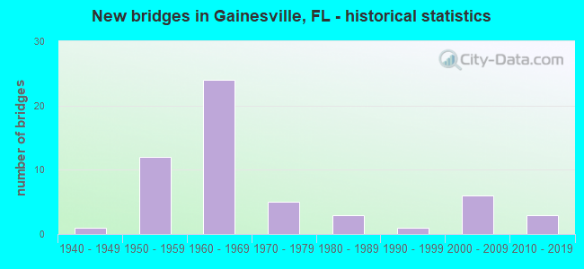
- New bridges - historical statistics
- 11940-1949
- 121950-1959
- 241960-1969
- 51970-1979
- 31980-1989
- 11990-1999
- 62000-2009
- 32010-2019

- Reconstructed bridges - Historical Statistics
- 21970-1979
- 151980-1989
- 11990-1999


- Bridge Condition - Deck
- 78.9%Good
- 21.1%Satisfactory

- Bridge Condition - Superstructure
- 10.5%Very good
- 63.2%Good
- 26.3%Satisfactory

- Bridge Condition - Substructure
- 89.5%Good
- 5.3%Satisfactory
- 5.3%Poor

- Bridge Condition - Channel
- 32.3%Good
- 51.6%Satisfactory
- 9.7%Fair
- 6.5%Poor

- Bridge Condition - Culverts
- 54.5%Good
- 45.5%Satisfactory
Find on map >> Show street view
Structure Number: 260018, Location: 1.3 MI. N. OF SR-331 (Lat: 29.634156, Lng: -82.339364), Route carried "on" structure: US 441, Year Built: 1957, Year Reconstructed: 1970, Status: Open, Structure Length: 0.76m (2.49ft), Average Daily Traffic: 19,200 (year 2020), Truck Traffic: 6%, Average Future Daily Traffic: 33,312 (year 2042), Design Load: H 20, Features Intersected: TUMBLIN CREEK
Minimum Vertical Clearance: 30+ m (98+ ft), Kilometerpoint: 20.875, Lanes on structure: 4, Base Highway Network: Yes, Owner: State Highway Agency, Approaching Roadway Width: 20.4m (66.9ft), Skew: 14 degrees, Material/Design: Concrete, Design/Construction: Culvert, Number Of Spans In Main Unit: 3, Length of Maximum Span: 2.4m (7.9ft)
Condition: Channel: Good, Culverts: Satisfactory, Operating Rating: 55.3 metric tons, Method Used To Determine Operating Rating: Load Factor (LF), Inventory Rating: 32.6 metric tons, Method Used To Determine Inventory Rating: Load Factor (LF), Structural Evaluation: Equal to present minimum criteria, Waterway Adequacy: Equal to present desirable criteria, Approach Roadway Alignment: Equal to present desirable criteria, Designated Inspection Frequency: Every 24 months, Inspection Date: June 2020
Find on map >> Show street view
Structure Number: 260029, Location: 1.3 MI NORTH OF SR 121 (Lat: 29.773278, Lng: -82.348111), Route carried "on" structure: County highway 231, Year Built: 1941, Status: Open, Structure Length: 0.63m (2.07ft), Average Daily Traffic: 4,100 (year 2021), Truck Traffic: 3%, Average Future Daily Traffic: 7,114 (year 2042), Design Load: HS 20, Features Intersected: ROCKY CREEK
Minimum Vertical Clearance: 30+ m (98+ ft), Kilometerpoint: 2.140, Lanes on structure: 2, Owner: County Highway Agency, Approaching Roadway Width: 6.7m (22.0ft), Material/Design: Concrete, Design/Construction: Culvert, Number Of Spans In Main Unit: 2, Length of Maximum Span: 3.1m (10.2ft)
Condition: Channel: Fair, Culverts: Satisfactory, Operating Rating: 52.6 metric tons, Method Used To Determine Operating Rating: Load Factor (LF), Inventory Rating: 31.8 metric tons, Method Used To Determine Inventory Rating: Load Factor (LF), Structural Evaluation: Equal to present minimum criteria, Waterway Adequacy: Better than present minimum criteria, Approach Roadway Alignment: Equal to present desirable criteria, Designated Inspection Frequency: Every 24 months, Inspection Date: October 2021
Find on map >> Show street view
Structure Number: 260031, Location: 0.1 MI. E. OF SR-222 (Lat: 29.687892, Lng: -82.220836), Route carried "on" structure: State highway 26, Year Built: 1955, Year Reconstructed: 1993, Status: Open, Structure Length: 1.04m (3.41ft), Average Daily Traffic: 10,400 (year 2020), Truck Traffic: 6%, Average Future Daily Traffic: 18,044 (year 2042), Design Load: H 15, Features Intersected: LITTLE HATCHET CRK EAST
Minimum Vertical Clearance: 30+ m (98+ ft), Kilometerpoint: 10.223, Lanes on structure: 2, Base Highway Network: Yes, Owner: State Highway Agency, Approaching Roadway Width: 9.9m (32.5ft), Material/Design: Concrete, Design/Construction: Culvert, Number Of Spans In Main Unit: 3, Length of Maximum Span: 3.4m (11.2ft)
Condition: Channel: Good, Culverts: Good, Operating Rating: 58.4 metric tons, Method Used To Determine Operating Rating: Load Factor (LF), Inventory Rating: 35.0 metric tons, Method Used To Determine Inventory Rating: Load Factor (LF), Structural Evaluation: Better than present minimum criteria, Waterway Adequacy: Equal to present desirable criteria, Approach Roadway Alignment: Equal to present desirable criteria, Designated Inspection Frequency: Every 24 months, Inspection Date: July 2021
Find on map >> Show street view
Structure Number: 260033, Location: 1.2 MI. E. OF SR-222 (Lat: 29.687911, Lng: -82.206369), Route carried "on" structure: State highway 26, Year Built: 1959, Status: Open, Structure Length: 6.10m (20.01ft), Average Daily Traffic: 10,400 (year 2020), Truck Traffic: 6%, Average Future Daily Traffic: 18,044 (year 2042), Design Load: H 20, Features Intersected: HATCHET CREEK
Minimum Vertical Clearance: 30+ m (98+ ft), Kilometerpoint: 11.594, Lanes on structure: 2, Base Highway Network: Yes, Owner: State Highway Agency, Approaching Roadway Width: 9.8m (32.2ft), Material/Design: Concrete, Design/Construction: Slab, Number Of Spans In Main Unit: 10, Length of Maximum Span: 6.1m (20.0ft), Curb-To-Curb Width: 8.5m (27.9ft), Out-to-Out Width: 10.4m (34.1ft)
Condition: Deck: Satisfactory, Superstructure: Satisfactory, Substructure: Poor, Channel: Poor, Operating Rating: 54.4 metric tons, Method Used To Determine Operating Rating: Load Testing, Inventory Rating: 32.6 metric tons, Method Used To Determine Inventory Rating: Load Testing, Structural Evaluation: Meets minimum limits, Deck Geometry: Meets minimum limits, Waterway Adequacy: Equal to present desirable criteria, Approach Roadway Alignment: Equal to present desirable criteria, Length Of Structure Improvement: 6.10m (20.01ft), Designated Inspection Frequency: Every 24 months, Other Special Inspection Frequency: Every 12 months, Inspection Date: December 2020, Other Special Inspection Date: December 2021, Bridge Improvement Cost: $270,000, Roadway Improvement Cost: $27,000, Total Project Cost: $405,000, Deck Structure Type: Concrete Cast-file-Place
Find on map >> Show street view
Structure Number: 260035, Location: 0.3 MI WEST OF US 441 (Lat: 29.674167, Lng: -82.344444), Route carried "on" structure: City street , Year Built: 1966, Status: Open, Structure Length: 0.76m (2.49ft), Average Daily Traffic: 9,300 (year 2021), Truck Traffic: 3%, Average Future Daily Traffic: 16,136 (year 2042), Design Load: HS 20, Features Intersected: HOGTOWN CREEK, Facility Carried by Structure: NW 23RD BLVD
Minimum Vertical Clearance: 30+ m (98+ ft), Kilometerpoint: 3.492, Lanes on structure: 2, Owner: City or Municipal Highway Agency, Approaching Roadway Width: 8.5m (27.9ft), Material/Design: Concrete, Design/Construction: Culvert, Number Of Spans In Main Unit: 2, Length of Maximum Span: 3.8m (12.5ft), Curb or Sidewalk Widths: Left: 0.0m, Right: 1.5m (4.9ft)
Condition: Channel: Satisfactory, Culverts: Good, Inventory Rating: 57.2 metric tons, Method Used To Determine Inventory Rating: Allowable Stress (AS), Structural Evaluation: Better than present minimum criteria, Waterway Adequacy: Equal to present desirable criteria, Approach Roadway Alignment: Equal to present minimum criteria, Length Of Structure Improvement: 0.82m (2.69ft), Designated Inspection Frequency: Every 24 months, Inspection Date: October 2021, Bridge Improvement Cost: $110,000, Roadway Improvement Cost: $30,000, Total Project Cost: $154,000
Find on map >> Show street view
Structure Number: 260037, Location: US-441 OVER NW. 8th AVE. (Lat: 29.659203, Lng: -82.339164), Route carried "on" structure: US 441, Year Built: 1955, Status: Open, Structure Length: 3.23m (10.60ft), Average Daily Traffic: 27,000 (year 2020), Truck Traffic: 6%, Average Future Daily Traffic: 46,845 (year 2042), Design Load: HS 20, Features Intersected: NW. 8th AVE.
Minimum Vertical Clearance: 30+ m (98+ ft), Kilometerpoint: 23.672, Lanes on structure: 4, Lanes under structure: 2, Base Highway Network: Yes, Owner: State Highway Agency, Approaching Roadway Width: 19.5m (64.0ft), Material/Design: Concrete, Design/Construction: Tee Beam, Number Of Spans In Main Unit: 3, Length of Maximum Span: 12.8m (42.0ft), Curb or Sidewalk Widths: Left: 1.5m (4.9ft), Right: 1.5m (4.9ft), Curb-To-Curb Width: 15.7m (51.5ft), Out-to-Out Width: 19.5m (64.0ft)
Condition: Deck: Satisfactory, Superstructure: Satisfactory, Substructure: Good, Operating Rating: 50.8 metric tons, Method Used To Determine Operating Rating: Load Factor (LF), Inventory Rating: 30.4 metric tons, Method Used To Determine Inventory Rating: Load Factor (LF), Structural Evaluation: Equal to present minimum criteria, Deck Geometry: Meets minimum limits, Underclear: Somewhat better than minimum adequacy, Approach Roadway Alignment: Equal to present desirable criteria, Length Of Structure Improvement: 3.23m (10.60ft), Designated Inspection Frequency: Every 24 months, Inspection Date: September 2020, Bridge Improvement Cost: $142,000, Roadway Improvement Cost: $14,000, Total Project Cost: $220,000, Deck Structure Type: Concrete Cast-file-Place
Find on map >> Show street view
Structure Number: 260038, Location: 0.2 MI. W. OF SR-121 (Lat: 29.651944, Lng: -82.374722), Route carried "on" structure: State highway 26, Year Built: 1957, Year Reconstructed: 1984, Status: Open, Structure Length: 3.66m (12.01ft), Average Daily Traffic: 17,900 (year 2020), Truck Traffic: 3%, Average Future Daily Traffic: 31,056 (year 2042), Design Load: H 20, Features Intersected: HOGTOWN CREEK
Minimum Vertical Clearance: 30+ m (98+ ft), Kilometerpoint: 27.924, Lanes on structure: 5, Base Highway Network: Yes, Owner: State Highway Agency, Approaching Roadway Width: 20.7m (67.9ft), Material/Design: Concrete, Design/Construction: Slab, Number Of Spans In Main Unit: 8, Length of Maximum Span: 4.6m (15.1ft), Curb or Sidewalk Widths: Left: 1.5m (4.9ft), Right: 1.5m (4.9ft), Curb-To-Curb Width: 20.7m (67.9ft), Out-to-Out Width: 24.5m (80.4ft)
Condition: Deck: Satisfactory, Superstructure: Satisfactory, Substructure: Satisfactory, Channel: Satisfactory, Operating Rating: 26.6 metric tons, Method Used To Determine Operating Rating: Load Testing, Inventory Rating: 20.5 metric tons, Method Used To Determine Inventory Rating: Load Testing, Structural Evaluation: Somewhat better than minimum adequacy, Deck Geometry: Somewhat better than minimum adequacy, Waterway Adequacy: Equal to present desirable criteria, Approach Roadway Alignment: Equal to present desirable criteria, Designated Inspection Frequency: Every 24 months, Inspection Date: September 2020, Deck Structure Type: Concrete Cast-file-Place
Find on map >> Show street view
Structure Number: 260042, Location: 1.3 MI. E. OF SR-20 (Lat: 29.651944, Lng: -82.284444), Route carried "on" structure: State highway 26, Year Built: 1972, Status: Open, Structure Length: 0.67m (2.20ft), Average Daily Traffic: 9,900 (year 2020), Truck Traffic: 6%, Average Future Daily Traffic: 17,176 (year 2042), Design Load: HS 20+Mod, Features Intersected: DRAINAGE CANAL
Minimum Vertical Clearance: 30+ m (98+ ft), Kilometerpoint: 2.195, Lanes on structure: 4, Owner: State Highway Agency, Approaching Roadway Width: 17.7m (58.1ft), Skew: 20 degrees, Material/Design: Concrete, Design/Construction: Culvert, Number Of Spans In Main Unit: 3, Length of Maximum Span: 2.1m (6.9ft)
Condition: Channel: Satisfactory, Culverts: Good, Operating Rating: 71.2 metric tons, Method Used To Determine Operating Rating: Load Factor (LF), Inventory Rating: 42.8 metric tons, Method Used To Determine Inventory Rating: Load Factor (LF), Structural Evaluation: Better than present minimum criteria, Waterway Adequacy: Equal to present desirable criteria, Approach Roadway Alignment: Equal to present desirable criteria, Designated Inspection Frequency: Every 24 months, Inspection Date: June 2020
Find on map >> Show street view
Structure Number: 260048, Location: 2.6 MI. SW. OF SR-222 (Lat: 29.666958, Lng: -82.248492), Route carried "on" structure: State highway 26, Year Built: 1959, Year Reconstructed: 1993, Status: Open, Structure Length: 0.65m (2.13ft), Average Daily Traffic: 5,100 (year 2020), Truck Traffic: 6%, Average Future Daily Traffic: 8,848 (year 2042), Design Load: H 15, Features Intersected: LAKE RIDGE CREEK
Minimum Vertical Clearance: 30+ m (98+ ft), Kilometerpoint: 5.897, Lanes on structure: 2, Owner: State Highway Agency, Approaching Roadway Width: 10.2m (33.5ft), Material/Design: Concrete, Design/Construction: Culvert, Number Of Spans In Main Unit: 2, Length of Maximum Span: 3.0m (9.8ft)
Condition: Channel: Satisfactory, Culverts: Satisfactory, Operating Rating: 65.9 metric tons, Method Used To Determine Operating Rating: Load Factor (LF), Inventory Rating: 39.6 metric tons, Method Used To Determine Inventory Rating: Load Factor (LF), Structural Evaluation: Equal to present minimum criteria, Waterway Adequacy: Equal to present desirable criteria, Approach Roadway Alignment: Equal to present desirable criteria, Designated Inspection Frequency: Every 24 months, Inspection Date: January 2022
Find on map >> Show street view
Structure Number: 260049, Location: 0.9 MI. SW. OF SR-222 (Lat: 29.679328, Lng: -82.234406), Route carried "on" structure: State highway 26, Year Built: 1959, Year Reconstructed: 1993, Status: Open, Structure Length: 0.66m (2.17ft), Average Daily Traffic: 3,500 (year 2020), Truck Traffic: 6%, Average Future Daily Traffic: 6,072 (year 2042), Design Load: H 15, Features Intersected: LITTLE HATCHET CREEK
Minimum Vertical Clearance: 30+ m (98+ ft), Kilometerpoint: 8.538, Lanes on structure: 2, Owner: State Highway Agency, Approaching Roadway Width: 10.4m (34.1ft), Material/Design: Concrete, Design/Construction: Culvert, Number Of Spans In Main Unit: 2, Length of Maximum Span: 3.0m (9.8ft)
Condition: Channel: Satisfactory, Culverts: Good, Operating Rating: 63.0 metric tons, Method Used To Determine Operating Rating: Load Factor (LF), Inventory Rating: 37.8 metric tons, Method Used To Determine Inventory Rating: Load Factor (LF), Structural Evaluation: Better than present minimum criteria, Waterway Adequacy: Equal to present desirable criteria, Approach Roadway Alignment: Equal to present desirable criteria, Designated Inspection Frequency: Every 24 months, Inspection Date: January 2022
Find on map >> Show street view
Structure Number: 260051, Location: 2.2 MI NORTH OF SR 24 (Lat: 29.734167, Lng: -82.276667), Route carried "on" structure: County highway 225, Year Built: 1952, Year Reconstructed: 1987, Status: Open, Structure Length: 1.14m (3.74ft), Average Daily Traffic: 2,300 (year 2021), Truck Traffic: 3%, Average Future Daily Traffic: 3,991 (year 2042), Design Load: HS 20, Features Intersected: HATCHETT CREEK
Minimum Vertical Clearance: 30+ m (98+ ft), Kilometerpoint: 3.545, Lanes on structure: 3, Owner: County Highway Agency, Approaching Roadway Width: 11.0m (36.1ft), Skew: 3 degrees, Material/Design: Concrete, Design/Construction: Culvert, Number Of Spans In Main Unit: 3, Length of Maximum Span: 3.8m (12.5ft)
Condition: Channel: Satisfactory, Culverts: Satisfactory, Operating Rating: 47.3 metric tons, Method Used To Determine Operating Rating: Load Factor (LF), Inventory Rating: 28.3 metric tons, Method Used To Determine Inventory Rating: Load Factor (LF), Structural Evaluation: Equal to present minimum criteria, Waterway Adequacy: Better than present minimum criteria, Approach Roadway Alignment: Equal to present desirable criteria, Designated Inspection Frequency: Every 24 months, Underwater Inspection Frequency: Every 24 months, Inspection Date: October 2021, Underwater Inspection Date: October 2021
Find on map >> Show street view
Structure Number: 260053, Location: 3.7 MI. E. OF SR-24 (Lat: 29.687950, Lng: -82.238336), Route carried "on" structure: State highway 222, Year Built: 1959, Year Reconstructed: 1987, Status: Open, Structure Length: 1.16m (3.81ft), Average Daily Traffic: 7,000 (year 2020), Truck Traffic: 3%, Average Future Daily Traffic: 12,145 (year 2042), Design Load: HS 20, Features Intersected: LITTLE HATCHET CREEK
Minimum Vertical Clearance: 30+ m (98+ ft), Kilometerpoint: 21.557, Lanes on structure: 2, Base Highway Network: Yes, Owner: State Highway Agency, Approaching Roadway Width: 9.8m (32.2ft), Material/Design: Concrete, Design/Construction: Culvert, Number Of Spans In Main Unit: 3, Length of Maximum Span: 3.7m (12.1ft)
Condition: Channel: Satisfactory, Culverts: Satisfactory, Inventory Rating: 63.0 metric tons, Method Used To Determine Inventory Rating: Load Factor (LF), Structural Evaluation: Equal to present minimum criteria, Waterway Adequacy: Equal to present desirable criteria, Approach Roadway Alignment: Equal to present desirable criteria, Designated Inspection Frequency: Every 24 months, Inspection Date: May 2020
Find on map >> Show street view
Structure Number: 260054, Location: I-75 SB/SR-24 (Lat: 29.617222, Lng: -82.386111), Route carried "on" structure: Interstate 75, Year Built: 1964, Year Reconstructed: 1994, Status: Open, Structure Length: 6.46m (21.19ft), Average Daily Traffic: 29,000 (year 2020), Truck Traffic: 34%, Average Future Daily Traffic: 50,315 (year 2042), Design Load: HS 20, Features Intersected: SR-24
Minimum Vertical Clearance: 30+ m (98+ ft), Kilometerpoint: 17.704, Lanes on structure: 3, Lanes under structure: 7, Base Highway Network: Yes, Owner: State Highway Agency, Approaching Roadway Width: 17.2m (56.4ft), Material/Design: Prestressed concrete, Design/Construction: Stringer/Multi-beam, Number Of Spans In Main Unit: 4, Length of Maximum Span: 18.3m (60.0ft), Curb-To-Curb Width: 17.0m (55.8ft), Out-to-Out Width: 18.0m (59.1ft)
Condition: Deck: Good, Superstructure: Very good, Substructure: Good, Operating Rating: 46.3 metric tons, Method Used To Determine Operating Rating: Load Factor (LF), Inventory Rating: 27.9 metric tons, Method Used To Determine Inventory Rating: Load Factor (LF), Structural Evaluation: Better than present minimum criteria, Deck Geometry: Equal to present minimum criteria, Underclear: Meets minimum limits, Approach Roadway Alignment: Equal to present desirable criteria, Designated Inspection Frequency: Every 24 months, Inspection Date: November 2020, Deck Structure Type: Concrete Cast-file-Place
Find on map >> Show street view
Structure Number: 260055, Location: 1.3 MI. N. OF SR-24 (Lat: 29.632222, Lng: -82.396667), Route carried "on" structure: Interstate 75, Year Built: 1964, Year Reconstructed: 1993, Status: Open, Structure Length: 4.57m (14.99ft), Average Daily Traffic: 34,250 (year 2020), Truck Traffic: 34%, Average Future Daily Traffic: 59,424 (year 2042), Design Load: HS 20, Features Intersected: HOGTOWN CREEK
Minimum Vertical Clearance: 30+ m (98+ ft), Kilometerpoint: 19.640, Lanes on structure: 3, Base Highway Network: Yes, Owner: State Highway Agency, Approaching Roadway Width: 17.7m (58.1ft), Material/Design: Prestressed concrete, Design/Construction: Stringer/Multi-beam, Number Of Spans In Main Unit: 3, Length of Maximum Span: 15.2m (49.9ft), Curb-To-Curb Width: 17.0m (55.8ft), Out-to-Out Width: 17.8m (58.4ft)
Condition: Deck: Good, Superstructure: Good, Substructure: Good, Channel: Good, Operating Rating: 54.2 metric tons, Method Used To Determine Operating Rating: Load Factor (LF), Inventory Rating: 38.8 metric tons, Method Used To Determine Inventory Rating: Load Factor (LF), Structural Evaluation: Better than present minimum criteria, Deck Geometry: Equal to present minimum criteria, Waterway Adequacy: Equal to present desirable criteria, Approach Roadway Alignment: Equal to present desirable criteria, Designated Inspection Frequency: Every 24 months, Underwater Inspection Frequency: Every 24 months, Inspection Date: March 2021, Underwater Inspection Date: March 2021, Deck Structure Type: Concrete Cast-file-Place
Find on map >> Show street view
Structure Number: 260056, Location: 1.9 MI N. OF SR-24 (Lat: 29.639942, Lng: -82.402042), Route carried "on" structure: County highway 2074, Year Built: 1964, Year Reconstructed: 1999, Status: Open, Structure Length: 8.11m (26.61ft), Average Daily Traffic: 16,000 (year 2020), Truck Traffic: 3%, Average Future Daily Traffic: 27,760 (year 2042), Design Load: HS 20+Mod, Features Intersected: I-75 (SR-93)
Minimum Vertical Clearance: 30+ m (98+ ft), Kilometerpoint: 2.427, Lanes on structure: 2, Lanes under structure: 6, Owner: State Highway Agency, Approaching Roadway Width: 11.0m (36.1ft), Skew: 3 degrees, Material/Design: Prestressed concrete, Design/Construction: Stringer/Multi-beam, Number Of Spans In Main Unit: 4, Length of Maximum Span: 26.2m (86.0ft), Curb-To-Curb Width: 13.2m (43.3ft), Out-to-Out Width: 14.2m (46.6ft)
Condition: Deck: Satisfactory, Superstructure: Good, Substructure: Good, Operating Rating: 64.5 metric tons, Method Used To Determine Operating Rating: Load Factor (LF), Inventory Rating: 38.6 metric tons, Method Used To Determine Inventory Rating: Load Factor (LF), Structural Evaluation: Better than present minimum criteria, Deck Geometry: Somewhat better than minimum adequacy, Underclear: Meets minimum limits, Approach Roadway Alignment: Equal to present desirable criteria, Designated Inspection Frequency: Every 24 months, Inspection Date: April 2021, Deck Structure Type: Concrete Cast-file-Place
Find on map >> Show street view
Structure Number: 260057, Location: I-75 SB OVER SR-26 (Lat: 29.659650, Lng: -82.419122), Route carried "on" structure: Interstate 75, Year Built: 1964, Year Reconstructed: 1994, Status: Open, Structure Length: 7.83m (25.69ft), Average Daily Traffic: 34,250 (year 2020), Truck Traffic: 34%, Average Future Daily Traffic: 59,424 (year 2042), Design Load: HS 20, Features Intersected: SR-26 NEWBERRY ROAD
Minimum Vertical Clearance: 30+ m (98+ ft), Kilometerpoint: 23.372, Lanes on structure: 4, Lanes under structure: 6, Base Highway Network: Yes, Owner: State Highway Agency, Approaching Roadway Width: 22.4m (73.5ft), Skew: 3 degrees, Material/Design: Prestressed concrete, Design/Construction: Stringer/Multi-beam, Number Of Spans In Main Unit: 4, Length of Maximum Span: 20.4m (66.9ft), Curb-To-Curb Width: 19.5m (64.0ft), Out-to-Out Width: 20.4m (66.9ft)
Condition: Deck: Good, Superstructure: Good, Substructure: Good, Operating Rating: 68.7 metric tons, Method Used To Determine Operating Rating: Load Testing, Inventory Rating: 41.2 metric tons, Method Used To Determine Inventory Rating: Load Testing, Structural Evaluation: Better than present minimum criteria, Deck Geometry: Somewhat better than minimum adequacy, Underclear: High priority of corrective action, Approach Roadway Alignment: Equal to present desirable criteria, Designated Inspection Frequency: Every 24 months, Inspection Date: July 2021, Total Project Cost: $250,000, Deck Structure Type: Concrete Cast-file-Place
Find on map >> Show street view
Structure Number: 260058, Location: 1.6 MI. N. OF SR-26 (Lat: 29.674336, Lng: -82.432100), Route carried "on" structure: County highway 3455, Year Built: 1963, Status: Open, Structure Length: 11.43m (37.50ft), Average Daily Traffic: 14,000 (year 2020), Truck Traffic: 3%, Average Future Daily Traffic: 24,290 (year 2042), Design Load: H 20, Features Intersected: I-75 (SR-93)
Minimum Vertical Clearance: 30+ m (98+ ft), Kilometerpoint: 1.329, Lanes on structure: 2, Lanes under structure: 6, Owner: State Highway Agency, Approaching Roadway Width: 12.1m (39.7ft), Skew: 4 degrees, Material/Design: Prestressed concrete, Design/Construction: Stringer/Multi-beam, Number Of Spans In Main Unit: 5, Length of Maximum Span: 27.1m (88.9ft), Curb or Sidewalk Widths: Left: 0.6m (2.0ft), Right: 1.5m (4.9ft), Curb-To-Curb Width: 8.6m (28.2ft), Out-to-Out Width: 10.4m (34.1ft)
Condition: Deck: Good, Superstructure: Good, Substructure: Good, Operating Rating: 47.4 metric tons, Method Used To Determine Operating Rating: Load Factor (LF), Inventory Rating: 34.3 metric tons, Method Used To Determine Inventory Rating: Load Factor (LF), Structural Evaluation: Better than present minimum criteria, Deck Geometry: Meets minimum limits, Underclear: Meets minimum limits, Approach Roadway Alignment: Equal to present desirable criteria, Length Of Structure Improvement: 11.43m (37.50ft), Designated Inspection Frequency: Every 24 months, Inspection Date: March 2021, Bridge Improvement Cost: $504,000, Roadway Improvement Cost: $50,000, Total Project Cost: $756,000, Deck Structure Type: Concrete Cast-file-Place
Find on map >> Show street view
Structure Number: 260063, Location: I-75 SB at SR-121 (Lat: 29.601994, Lng: -82.373419), Route carried "on" structure: Interstate 75, Year Built: 1964, Year Reconstructed: 1994, Status: Open, Structure Length: 6.19m (20.31ft), Average Daily Traffic: 56,500 (year 2020), Truck Traffic: 34%, Average Future Daily Traffic: 98,028 (year 2042), Design Load: HS 20, Features Intersected: SR-121 & 331 WILLISTON R
Minimum Vertical Clearance: 30+ m (98+ ft), Kilometerpoint: 15.612, Lanes on structure: 4, Lanes under structure: 5, Base Highway Network: Yes, Owner: State Highway Agency, Approaching Roadway Width: 19.8m (65.0ft), Material/Design: Prestressed concrete, Design/Construction: Stringer/Multi-beam, Number Of Spans In Main Unit: 4, Length of Maximum Span: 15.8m (51.8ft), Curb-To-Curb Width: 19.5m (64.0ft), Out-to-Out Width: 20.3m (66.6ft)
Condition: Deck: Good, Superstructure: Good, Substructure: Good, Operating Rating: 49.3 metric tons, Method Used To Determine Operating Rating: Load Factor (LF), Inventory Rating: 34.3 metric tons, Method Used To Determine Inventory Rating: Load Factor (LF), Structural Evaluation: Better than present minimum criteria, Deck Geometry: Somewhat better than minimum adequacy, Underclear: Equal to present minimum criteria, Approach Roadway Alignment: Equal to present desirable criteria, Designated Inspection Frequency: Every 24 months, Inspection Date: July 2021, Deck Structure Type: Concrete Cast-file-Place
Find on map >> Show street view
Structure Number: 260079, Location: I-75 NB at SR-121 (Lat: 29.602158, Lng: -82.373194), Route carried "on" structure: Interstate 75, Year Built: 1964, Year Reconstructed: 1994, Status: Open, Structure Length: 6.19m (20.31ft), Average Daily Traffic: 28,250 (year 2020), Truck Traffic: 24%, Average Future Daily Traffic: 49,014 (year 2042), Design Load: H 20, Features Intersected: SR-121 & 331 WILLISTON R
Minimum Vertical Clearance: 30+ m (98+ ft), Kilometerpoint: 15.612, Lanes on structure: 4, Lanes under structure: 5, Base Highway Network: Yes, Owner: State Highway Agency, Approaching Roadway Width: 20.4m (66.9ft), Material/Design: Prestressed concrete, Design/Construction: Stringer/Multi-beam, Number Of Spans In Main Unit: 4, Length of Maximum Span: 15.8m (51.8ft), Curb-To-Curb Width: 19.5m (64.0ft), Out-to-Out Width: 20.3m (66.6ft)
Condition: Deck: Good, Superstructure: Satisfactory, Substructure: Good, Operating Rating: 51.3 metric tons, Method Used To Determine Operating Rating: Load Factor (LF), Inventory Rating: 30.7 metric tons, Method Used To Determine Inventory Rating: Load Factor (LF), Structural Evaluation: Equal to present minimum criteria, Deck Geometry: Somewhat better than minimum adequacy, Underclear: Equal to present minimum criteria, Approach Roadway Alignment: Equal to present desirable criteria, Designated Inspection Frequency: Every 24 months, Inspection Date: July 2021, Deck Structure Type: Concrete Cast-file-Place
Find on map >> Show street view
Structure Number: 260081, Location: 1.3 MI. N. OF SR-24 (Lat: 29.632269, Lng: -82.396489), Route carried "on" structure: Interstate 75, Year Built: 1964, Year Reconstructed: 1993, Status: Open, Structure Length: 4.57m (14.99ft), Average Daily Traffic: 34,250 (year 2020), Truck Traffic: 34%, Average Future Daily Traffic: 59,424 (year 2042), Design Load: HS 20, Features Intersected: HOGTOWN CREEK
Minimum Vertical Clearance: 30+ m (98+ ft), Kilometerpoint: 19.640, Lanes on structure: 3, Base Highway Network: Yes, Owner: State Highway Agency, Approaching Roadway Width: 17.7m (58.1ft), Material/Design: Prestressed concrete, Design/Construction: Stringer/Multi-beam, Number Of Spans In Main Unit: 3, Length of Maximum Span: 15.2m (49.9ft), Curb-To-Curb Width: 17.0m (55.8ft), Out-to-Out Width: 17.8m (58.4ft)
Condition: Deck: Good, Superstructure: Very good, Substructure: Good, Channel: Good, Operating Rating: 54.2 metric tons, Method Used To Determine Operating Rating: Load Factor (LF), Inventory Rating: 38.8 metric tons, Method Used To Determine Inventory Rating: Load Factor (LF), Structural Evaluation: Better than present minimum criteria, Deck Geometry: Equal to present minimum criteria, Waterway Adequacy: Equal to present desirable criteria, Approach Roadway Alignment: Equal to present desirable criteria, Designated Inspection Frequency: Every 24 months, Underwater Inspection Frequency: Every 24 months, Inspection Date: March 2021, Underwater Inspection Date: March 2021, Deck Structure Type: Concrete Cast-file-Place
Find on map >> Show street view
Structure Number: 260082, Location: I-75 NB OVER SR-26 (Lat: 29.659722, Lng: -82.418889), Route carried "on" structure: Interstate 75, Year Built: 1964, Year Reconstructed: 1994, Status: Open, Structure Length: 7.83m (25.69ft), Average Daily Traffic: 34,250 (year 2020), Truck Traffic: 34%, Average Future Daily Traffic: 59,424 (year 2042), Design Load: HS 20, Features Intersected: SR-26 NEWBERRY ROAD
Minimum Vertical Clearance: 30+ m (98+ ft), Kilometerpoint: 23.355, Lanes on structure: 3, Lanes under structure: 6, Base Highway Network: Yes, Owner: State Highway Agency, Approaching Roadway Width: 17.1m (56.1ft), Skew: 3 degrees, Material/Design: Prestressed concrete, Design/Construction: Stringer/Multi-beam, Number Of Spans In Main Unit: 4, Length of Maximum Span: 20.4m (66.9ft), Curb-To-Curb Width: 17.1m (56.1ft), Out-to-Out Width: 17.9m (58.7ft)
Condition: Deck: Good, Superstructure: Satisfactory, Substructure: Good, Operating Rating: 65.5 metric tons, Method Used To Determine Operating Rating: Load Testing, Inventory Rating: 39.3 metric tons, Method Used To Determine Inventory Rating: Load Testing, Structural Evaluation: Equal to present minimum criteria, Deck Geometry: Equal to present minimum criteria, Underclear: High priority of corrective action, Approach Roadway Alignment: Equal to present desirable criteria, Designated Inspection Frequency: Every 24 months, Inspection Date: July 2021, Total Project Cost: $250,000, Deck Structure Type: Concrete Cast-file-Place
Find on map >> Show street view
Structure Number: 260083, Location: 0.2 MI EAST OF SR 121 (Lat: 29.659444, Lng: -82.368611), Route carried "on" structure: County highway 338, Year Built: 1968, Status: Open, Structure Length: 0.96m (3.15ft), Average Daily Traffic: 6,600 (year 2021), Truck Traffic: 3%, Average Future Daily Traffic: 11,451 (year 2042), Design Load: HS 20, Features Intersected: BRANCH OF POSSUM CREEK, Facility Carried by Structure: NW 8TH AVENUE
Minimum Vertical Clearance: 30+ m (98+ ft), Kilometerpoint: 1.469, Lanes on structure: 3, Owner: City or Municipal Highway Agency, Approaching Roadway Width: 15.2m (49.9ft), Material/Design: Concrete, Design/Construction: Culvert, Number Of Spans In Main Unit: 3, Length of Maximum Span: 3.3m (10.8ft)
Condition: Channel: Satisfactory, Culverts: Good, Inventory Rating: 55.9 metric tons, Method Used To Determine Inventory Rating: Load Factor (LF), Structural Evaluation: Better than present minimum criteria, Waterway Adequacy: Equal to present minimum criteria, Approach Roadway Alignment: Equal to present desirable criteria, Designated Inspection Frequency: Every 24 months, Inspection Date: October 2021
Find on map >> Show street view
Structure Number: 260084, Location: 0.7 MI EAST OF SR 121 (Lat: 29.659447, Lng: -82.360911), Route carried "on" structure: City street 338, Year Built: 1968, Status: Open, Structure Length: 1.31m (4.30ft), Average Daily Traffic: 6,600 (year 2021), Truck Traffic: 3%, Average Future Daily Traffic: 11,451 (year 2042), Design Load: HS 20, Features Intersected: BRANCH OF HOGTOWN CREEK, Facility Carried by Structure: NW 8TH AVENUE
Minimum Vertical Clearance: 30+ m (98+ ft), Kilometerpoint: 2.237, Lanes on structure: 3, Owner: City or Municipal Highway Agency, Approaching Roadway Width: 13.4m (44.0ft), Skew: 4 degrees, Material/Design: Concrete, Design/Construction: Culvert, Number Of Spans In Main Unit: 3, Length of Maximum Span: 4.5m (14.8ft)
Condition: Channel: Poor, Culverts: Good, Inventory Rating: 84.7 metric tons, Method Used To Determine Inventory Rating: Load Factor (LF), Structural Evaluation: Better than present minimum criteria, Waterway Adequacy: Equal to present minimum criteria, Approach Roadway Alignment: Equal to present minimum criteria, Designated Inspection Frequency: Every 24 months, Underwater Inspection Frequency: Every 24 months, Other Special Inspection Frequency: Every 12 months, Inspection Date: October 2021, Underwater Inspection Date: October 2021, Other Special Inspection Date: October 2021
Find on map >> Show street view
Structure Number: 260092, Location: 0.3 MI. S. OF SR-222 (Lat: 29.688061, Lng: -82.339014), Route carried "on" structure: US 441, Year Built: 1958, Status: Open, Structure Length: 0.67m (2.20ft), Average Daily Traffic: 26,000 (year 2020), Truck Traffic: 6%, Average Future Daily Traffic: 45,110 (year 2042), Design Load: H 15, Features Intersected: HOGTOWN CREEK
Minimum Vertical Clearance: 30+ m (98+ ft), Kilometerpoint: 26.620, Lanes on structure: 4, Base Highway Network: Yes, Owner: State Highway Agency, Approaching Roadway Width: 19.5m (64.0ft), Skew: 24 degrees, Material/Design: Concrete, Design/Construction: Culvert, Number Of Spans In Main Unit: 2, Length of Maximum Span: 2.4m (7.9ft)
Condition: Channel: Fair, Culverts: Satisfactory, Structural Evaluation: Equal to present minimum criteria, Waterway Adequacy: Better than present minimum criteria, Approach Roadway Alignment: Equal to present desirable criteria, Designated Inspection Frequency: Every 24 months, Inspection Date: September 2020
Find on map >> Show street view
Structure Number: 260095, Location: 0.6 MI. E. OF CR-225A (Lat: 29.730433, Lng: -82.249078), Route carried "on" structure: State highway 24, Year Built: 1975, Status: Open, Structure Length: 1.16m (3.81ft), Average Daily Traffic: 16,200 (year 2020), Truck Traffic: 12%, Average Future Daily Traffic: 28,107 (year 2042), Design Load: HS 20, Features Intersected: HATCHET CREEK
Minimum Vertical Clearance: 30+ m (98+ ft), Kilometerpoint: 16.121, Lanes on structure: 4, Base Highway Network: Yes, Owner: State Highway Agency, Approaching Roadway Width: 18.9m (62.0ft), Skew: 10 degrees, Material/Design: Concrete, Design/Construction: Culvert, Number Of Spans In Main Unit: 3, Length of Maximum Span: 3.7m (12.1ft)
Condition: Channel: Good, Culverts: Satisfactory, Structural Evaluation: Equal to present minimum criteria, Waterway Adequacy: Equal to present desirable criteria, Approach Roadway Alignment: Equal to present desirable criteria, Designated Inspection Frequency: Every 24 months, Inspection Date: December 2020
Find on map >> Show street view
Structure Number: 260096, Location: 1.3 MI. E. OF CR-225A (Lat: 29.737556, Lng: -82.239383), Route carried "on" structure: State highway 24, Year Built: 1975, Status: Open, Structure Length: 1.14m (3.74ft), Average Daily Traffic: 16,200 (year 2020), Truck Traffic: 12%, Average Future Daily Traffic: 28,107 (year 2042), Design Load: HS 20, Features Intersected: HATCHET CREEK
Minimum Vertical Clearance: 30+ m (98+ ft), Kilometerpoint: 17.300, Lanes on structure: 4, Base Highway Network: Yes, Owner: State Highway Agency, Approaching Roadway Width: 18.6m (61.0ft), Skew: 13 degrees, Material/Design: Concrete, Design/Construction: Culvert, Number Of Spans In Main Unit: 3, Length of Maximum Span: 2.7m (8.9ft)
Condition: Channel: Satisfactory, Culverts: Satisfactory, Structural Evaluation: Equal to present minimum criteria, Waterway Adequacy: Equal to present desirable criteria, Approach Roadway Alignment: Equal to present desirable criteria, Designated Inspection Frequency: Every 24 months, Inspection Date: December 2020
Find on map >> Show street view
Structure Number: 260097, Location: 1.5 MI WEST OF US 441 (Lat: 29.666667, Lng: -82.364167), Route carried "on" structure: County highway , Year Built: 1965, Year Reconstructed: 1985, Status: Open, Structure Length: 1.14m (3.74ft), Average Daily Traffic: 19,700 (year 2021), Truck Traffic: 3%, Average Future Daily Traffic: 34,180 (year 2042), Design Load: HS 20, Features Intersected: POSSUM CREEK, Facility Carried by Structure: NW 16TH AVE
Minimum Vertical Clearance: 30+ m (98+ ft), Kilometerpoint: 2.593, Lanes on structure: 4, Owner: County Highway Agency, Approaching Roadway Width: 15.8m (51.8ft), Skew: 20 degrees, Material/Design: Concrete, Design/Construction: Culvert, Number Of Spans In Main Unit: 3, Length of Maximum Span: 3.9m (12.8ft), Curb or Sidewalk Widths: Left: 1.5m (4.9ft), Right: 1.5m (4.9ft)
Condition: Channel: Fair, Culverts: Satisfactory, Operating Rating: 58.1 metric tons, Method Used To Determine Operating Rating: Load Factor (LF), Inventory Rating: 34.8 metric tons, Method Used To Determine Inventory Rating: Load Factor (LF), Structural Evaluation: Equal to present minimum criteria, Waterway Adequacy: Somewhat better than minimum adequacy, Approach Roadway Alignment: Equal to present desirable criteria, Designated Inspection Frequency: Every 24 months, Inspection Date: October 2021
Find on map >> Show street view
Structure Number: 260098, Location: 0.6 MI W OF US 441 (Lat: 29.666667, Lng: -82.348864), Route carried "on" structure: County highway , Year Built: 1965, Year Reconstructed: 1985, Status: Open, Structure Length: 0.94m (3.08ft), Average Daily Traffic: 19,700 (year 2021), Truck Traffic: 3%, Average Future Daily Traffic: 34,180 (year 2042), Design Load: HS 20, Features Intersected: HOGTOWN CREEK, Facility Carried by Structure: NW 16TH AVE
Minimum Vertical Clearance: 30+ m (98+ ft), Kilometerpoint: 4.052, Lanes on structure: 4, Owner: County Highway Agency, Approaching Roadway Width: 16.1m (52.8ft), Skew: 24 degrees, Material/Design: Concrete, Design/Construction: Culvert, Number Of Spans In Main Unit: 2, Length of Maximum Span: 4.5m (14.8ft), Curb or Sidewalk Widths: Left: 1.5m (4.9ft), Right: 1.5m (4.9ft)
Condition: Channel: Satisfactory, Culverts: Satisfactory, Inventory Rating: 59.8 metric tons, Method Used To Determine Inventory Rating: Load Factor (LF), Structural Evaluation: Equal to present minimum criteria, Waterway Adequacy: Better than present minimum criteria, Approach Roadway Alignment: Equal to present desirable criteria, Designated Inspection Frequency: Every 24 months, Inspection Date: October 2021
Find on map >> Show street view
Structure Number: 260101, Location: SR-222 OVER I-75 (Lat: 29.688889, Lng: -82.446389), Route carried "on" structure: State highway 222, Year Built: 2001, Status: Open, Structure Length: 11.68m (38.32ft), Average Daily Traffic: 28,500 (year 2020), Truck Traffic: 3%, Average Future Daily Traffic: 49,448 (year 2042), Design Load: HS 20, Features Intersected: I-75 (SR-93)
Minimum Vertical Clearance: 30+ m (98+ ft), Kilometerpoint: 0.278, Lanes on structure: 6, Lanes under structure: 7, Base Highway Network: Yes, Owner: State Highway Agency, Approaching Roadway Width: 17.7m (58.1ft), Skew: 24 degrees, Material/Design: Prestressed concrete, Design/Construction: Stringer/Multi-beam, Number Of Spans In Main Unit: 4, Length of Maximum Span: 38.3m (125.7ft), Curb or Sidewalk Widths: Left: 1.8m (5.9ft), Right: 1.8m (5.9ft), Curb-To-Curb Width: 25.6m (84.0ft), Out-to-Out Width: 33.3m (109.3ft)
Condition: Deck: Good, Superstructure: Good, Substructure: Good, Operating Rating: 66.0 metric tons, Method Used To Determine Operating Rating: Load Factor (LF), Inventory Rating: 39.6 metric tons, Method Used To Determine Inventory Rating: Load Factor (LF), Structural Evaluation: Better than present minimum criteria, Deck Geometry: Somewhat better than minimum adequacy, Underclear: Equal to present minimum criteria, Approach Roadway Alignment: Equal to present desirable criteria, Designated Inspection Frequency: Every 24 months, Inspection Date: July 2020, Deck Structure Type: Concrete Cast-file-Place
Find on map >> Show street view
Structure Number: 260103, Location: 4.8 MI. E. OF SR-26 (Lat: 29.611258, Lng: -82.248164), Route carried "on" structure: State highway 20, Year Built: 2000, Status: Open, Structure Length: 5.68m (18.64ft), Average Daily Traffic: 4,300 (year 2020), Truck Traffic: 5%, Average Future Daily Traffic: 7,460 (year 2042), Design Load: HS 20+Mod, Features Intersected: PRAIRIE CRK. & BIKE PATH
Minimum Vertical Clearance: 30+ m (98+ ft), Kilometerpoint: 8.008, Lanes on structure: 2, Base Highway Network: Yes, Owner: State Highway Agency, Approaching Roadway Width: 10.1m (33.1ft), Skew: 3 degrees, Material/Design: Concrete continuous, Design/Construction: Slab, Number Of Spans In Main Unit: 8, Length of Maximum Span: 7.1m (23.3ft), Curb-To-Curb Width: 12.2m (40.0ft), Out-to-Out Width: 13.1m (43.0ft)
Condition: Deck: Good, Superstructure: Good, Substructure: Good, Channel: Satisfactory, Operating Rating: 63.5 metric tons, Method Used To Determine Operating Rating: Load Factor (LF), Inventory Rating: 38.1 metric tons, Method Used To Determine Inventory Rating: Load Factor (LF), Structural Evaluation: Better than present minimum criteria, Deck Geometry: Better than present minimum criteria, Waterway Adequacy: Equal to present desirable criteria, Approach Roadway Alignment: Equal to present desirable criteria, Designated Inspection Frequency: Every 24 months, Underwater Inspection Frequency: Every 24 months, Inspection Date: July 2020, Underwater Inspection Date: July 2020, Deck Structure Type: Concrete Cast-file-Place
Find on map >> Show street view
Structure Number: 260104, Location: 4.8 MI. E. OF SR-26 (Lat: 29.611486, Lng: -82.248294), Route carried "on" structure: State highway 20, Year Built: 2000, Status: Open, Structure Length: 5.68m (18.64ft), Average Daily Traffic: 4,300 (year 2020), Truck Traffic: 5%, Average Future Daily Traffic: 7,460 (year 2042), Design Load: HS 20+Mod, Features Intersected: PRAIRIE CRK. & BIKE PATH
Minimum Vertical Clearance: 30+ m (98+ ft), Kilometerpoint: 8.000, Lanes on structure: 2, Base Highway Network: Yes, Owner: State Highway Agency, Approaching Roadway Width: 9.4m (30.8ft), Skew: 3 degrees, Material/Design: Concrete continuous, Design/Construction: Slab, Number Of Spans In Main Unit: 8, Length of Maximum Span: 7.1m (23.3ft), Curb-To-Curb Width: 12.2m (40.0ft), Out-to-Out Width: 13.1m (43.0ft)
Condition: Deck: Good, Superstructure: Good, Substructure: Good, Channel: Satisfactory, Operating Rating: 63.5 metric tons, Method Used To Determine Operating Rating: Load Factor (LF), Inventory Rating: 38.1 metric tons, Method Used To Determine Inventory Rating: Load Factor (LF), Structural Evaluation: Better than present minimum criteria, Deck Geometry: Better than present minimum criteria, Waterway Adequacy: Equal to present desirable criteria, Approach Roadway Alignment: Equal to present desirable criteria, Designated Inspection Frequency: Every 24 months, Underwater Inspection Frequency: Every 24 months, Inspection Date: July 2020, Underwater Inspection Date: July 2020, Deck Structure Type: Concrete Cast-file-Place
Find on map >> Show street view
Structure Number: 260115, Location: 0.2 MI. W. OF SR-121 (Lat: 29.650667, Lng: -82.375303), Route carried "on" structure: Business State highway 26A, Year Built: 2006, Status: Open, Structure Length: 3.66m (12.01ft), Average Daily Traffic: 13,300 (year 2020), Truck Traffic: 3%, Average Future Daily Traffic: 23,076 (year 2042), Design Load: HS 20, Features Intersected: HOGTOWN CREEK
Minimum Vertical Clearance: 30+ m (98+ ft), Kilometerpoint: 0.435, Lanes on structure: 4, Owner: State Highway Agency, Approaching Roadway Width: 7.5m (24.6ft), Skew: 20 degrees, Material/Design: Concrete, Design/Construction: Slab, Number Of Spans In Main Unit: 3, Length of Maximum Span: 12.2m (40.0ft), Curb or Sidewalk Widths: Left: 2.0m (6.6ft), Right: 5.1m (16.7ft), Curb-To-Curb Width: 21.9m (71.9ft), Out-to-Out Width: 29.6m (97.1ft)
Condition: Deck: Good, Superstructure: Good, Substructure: Good, Channel: Good, Operating Rating: 56.2 metric tons, Method Used To Determine Operating Rating: Load Factor (LF), Inventory Rating: 32.7 metric tons, Method Used To Determine Inventory Rating: Load Factor (LF), Structural Evaluation: Better than present minimum criteria, Deck Geometry: Superior to present desirable criteria, Waterway Adequacy: Equal to present desirable criteria, Approach Roadway Alignment: Equal to present desirable criteria, Designated Inspection Frequency: Every 24 months, Inspection Date: January 2022, Deck Structure Type: Concrete Cast-file-Place
Find on map >> Show street view
Structure Number: 26094, Location: 200 FT. N. OF SR-26 (Lat: 29.652833, Lng: -82.372403), Route carried "on" structure: State highway 121, Year Built: 1961, Year Reconstructed: 1980, Status: Open, Structure Length: 3.05m (10.01ft), Average Daily Traffic: 19,100 (year 2020), Truck Traffic: 3%, Average Future Daily Traffic: 33,138 (year 2042), Design Load: HS 20, Features Intersected: HOGTOWN CREEK
Minimum Vertical Clearance: 30+ m (98+ ft), Kilometerpoint: 5.456, Lanes on structure: 5, Owner: State Highway Agency, Approaching Roadway Width: 12.1m (39.7ft), Skew: 21 degrees, Material/Design: Concrete, Design/Construction: Slab, Number Of Spans In Main Unit: 5, Length of Maximum Span: 6.1m (20.0ft), Curb or Sidewalk Widths: Left: 1.5m (4.9ft), Right: 2.4m (7.9ft), Curb-To-Curb Width: 28.7m (94.2ft), Out-to-Out Width: 33.5m (109.9ft)
Condition: Deck: Good, Superstructure: Good, Substructure: Good, Channel: Good, Operating Rating: 44.4 metric tons, Method Used To Determine Operating Rating: Load Factor (LF), Inventory Rating: 27.2 metric tons, Method Used To Determine Inventory Rating: Load Factor (LF), Structural Evaluation: Equal to present minimum criteria, Deck Geometry: Superior to present desirable criteria, Waterway Adequacy: Equal to present desirable criteria, Approach Roadway Alignment: Equal to present desirable criteria, Designated Inspection Frequency: Every 24 months, Inspection Date: January 2021, Deck Structure Type: Concrete Cast-file-Place
Find on map >> Show street view
Structure Number: 260941, Location: 1.5 MI. N. OF SR-26 (Lat: 29.673611, Lng: -82.372222), Route carried "on" structure: State highway 121, Year Built: 1963, Status: Open, Structure Length: 0.95m (3.12ft), Average Daily Traffic: 14,500 (year 2020), Truck Traffic: 3%, Average Future Daily Traffic: 25,158 (year 2042), Design Load: H 15, Features Intersected: BRANCH OF HOGTOWN CREEK
Minimum Vertical Clearance: 30+ m (98+ ft), Kilometerpoint: 7.767, Lanes on structure: 2, Owner: State Highway Agency, Approaching Roadway Width: 9.9m (32.5ft), Material/Design: Concrete, Design/Construction: Culvert, Number Of Spans In Main Unit: 3, Length of Maximum Span: 3.0m (9.8ft)
Condition: Channel: Satisfactory, Culverts: Good, Inventory Rating: 58.8 metric tons, Method Used To Determine Inventory Rating: Load Factor (LF), Structural Evaluation: Better than present minimum criteria, Waterway Adequacy: Equal to present minimum criteria, Approach Roadway Alignment: Equal to present desirable criteria, Designated Inspection Frequency: Every 24 months, Inspection Date: March 2021
Find on map >> Show street view
Structure Number: 264137, Location: 1 MI WEST OF SR 121 (Lat: 29.800556, Lng: -82.401389), Route carried "on" structure: County highway , Year Built: 1988, Status: Open, Structure Length: 1.69m (5.54ft), Average Daily Traffic: 800 (year 2021), Truck Traffic: 3%, Average Future Daily Traffic: 1,388 (year 2042), Features Intersected: ROCKY CREEK, Facility Carried by Structure: NW 156TH AVE
Minimum Vertical Clearance: 30+ m (98+ ft), Kilometerpoint: 8.274, Lanes on structure: 2, Owner: County Highway Agency, Approaching Roadway Width: 7.3m (24.0ft), Material/Design: Concrete, Design/Construction: Culvert, Number Of Spans In Main Unit: 4, Length of Maximum Span: 4.3m (14.1ft)
Condition: Channel: Satisfactory, Culverts: Good, Operating Rating: 69.6 metric tons, Method Used To Determine Operating Rating: Load and Resistance Factor (LRFR), Inventory Rating: 46.7 metric tons, Method Used To Determine Inventory Rating: Load and Resistance Factor (LRFR), Structural Evaluation: Better than present minimum criteria, Waterway Adequacy: Better than present minimum criteria, Approach Roadway Alignment: Equal to present desirable criteria, Designated Inspection Frequency: Every 24 months, Inspection Date: November 2021
Find on map >> Show street view
Structure Number: 264145, Location: 1.0 MI E OF SR 121 (Lat: 29.785117, Lng: -82.361667), Route carried "on" structure: ServiceCounty highway , Year Built: 1990, Status: Open, Structure Length: 0.95m (3.12ft), Average Daily Traffic: 151 (year 2021), Truck Traffic: 10%, Average Future Daily Traffic: 262 (year 2042), Features Intersected: ROCKY CREEK, Facility Carried by Structure: NW 142ND AVE
Minimum Vertical Clearance: 30+ m (98+ ft), Kilometerpoint: 0.000, Lanes on structure: 2, Owner: County Highway Agency, Approaching Roadway Width: 6.3m (20.7ft), Material/Design: Concrete, Design/Construction: Culvert, Number Of Spans In Main Unit: 3, Length of Maximum Span: 3.3m (10.8ft)
Condition: Channel: Good, Culverts: Good, Operating Rating: 64.0 metric tons, Method Used To Determine Operating Rating: Load and Resistance Factor (LRFR), Inventory Rating: 41.2 metric tons, Method Used To Determine Inventory Rating: Load and Resistance Factor (LRFR), Structural Evaluation: Better than present minimum criteria, Waterway Adequacy: Somewhat better than minimum adequacy, Approach Roadway Alignment: Equal to present desirable criteria, Designated Inspection Frequency: Every 24 months, Inspection Date: October 2021
Find on map >> Show street view
Structure Number: 264626, Location: 0.2 MI WEST OF SR 24 (Lat: 29.681389, Lng: -82.295833), Route carried "on" structure: City street , Year Built: 1975, Status: Open, Structure Length: 0.66m (2.17ft), Average Daily Traffic: 1,200 (year 2021), Truck Traffic: 5%, Average Future Daily Traffic: 2,082 (year 2042), Design Load: HL 93, Features Intersected: LITTLE HATCHET CREEK, Facility Carried by Structure: NE 31ST AVE
Minimum Vertical Clearance: 30.18m (99.02ft), Kilometerpoint: 0.962, Lanes on structure: 2, Owner: City or Municipal Highway Agency, Approaching Roadway Width: 7.6m (24.9ft), Skew: 3 degrees, Material/Design: Concrete, Design/Construction: Culvert, Number Of Spans In Main Unit: 2, Length of Maximum Span: 3.2m (10.5ft), Curb-To-Curb Width: 12.2m (40.0ft), Out-to-Out Width: 12.8m (42.0ft)
Condition: Channel: Good, Culverts: Good, Operating Rating: 66.3 metric tons, Method Used To Determine Operating Rating: Load and Resistance Factor (LRFR), Inventory Rating: 51.2 metric tons, Method Used To Determine Inventory Rating: Load and Resistance Factor (LRFR), Structural Evaluation: Better than present minimum criteria, Deck Geometry: Better than present minimum criteria, Waterway Adequacy: Equal to present desirable criteria, Approach Roadway Alignment: Equal to present desirable criteria, Designated Inspection Frequency: Every 24 months, Inspection Date: September 2021
Find on map >> Show street view
Structure Number: 264875, Location: 1.25 MI WEST OF SR 121 (Lat: 29.638056, Lng: -82.392222), Route carried "on" structure: County highway , Year Built: 1974, Status: Open, Structure Length: 4.57m (14.99ft), Average Daily Traffic: 16,000 (year 2021), Truck Traffic: 3%, Average Future Daily Traffic: 27,760 (year 2042), Design Load: HS 20, Features Intersected: HOGTOWN CREEK, Facility Carried by Structure: SW 20TH AVE
Minimum Vertical Clearance: 30+ m (98+ ft), Kilometerpoint: 3.433, Lanes on structure: 2, Owner: County Highway Agency, Approaching Roadway Width: 10.7m (35.1ft), Skew: 4 degrees, Material/Design: Prestressed concrete, Design/Construction: Stringer/Multi-beam, Number Of Spans In Main Unit: 3, Length of Maximum Span: 15.2m (49.9ft), Curb-To-Curb Width: 12.2m (40.0ft), Out-to-Out Width: 12.8m (42.0ft)
Condition: Deck: Good, Superstructure: Good, Substructure: Good, Channel: Good, Operating Rating: 52.6 metric tons, Method Used To Determine Operating Rating: Load and Resistance Factor (LRFR), Inventory Rating: 31.7 metric tons, Method Used To Determine Inventory Rating: Load and Resistance Factor (LRFR), Structural Evaluation: Better than present minimum criteria, Deck Geometry: Somewhat better than minimum adequacy, Waterway Adequacy: Equal to present desirable criteria, Approach Roadway Alignment: Equal to present minimum criteria, Designated Inspection Frequency: Every 24 months, Underwater Inspection Frequency: Every 24 months, Inspection Date: October 2021, Underwater Inspection Date: October 2021, Deck Structure Type: Concrete Cast-file-Place
Find on map >> Show street view
Structure Number: 264877, Location: 0.3MI WEST OF SW 42ND ST (Lat: 29.625278, Lng: -82.391028), Route carried "on" structure: County highway 241, Year Built: 2016, Status: Open, Structure Length: 13.32m (43.70ft), Average Daily Traffic: 1,900 (year 2021), Truck Traffic: 1%, Average Future Daily Traffic: 3,297 (year 2042), Design Load: HL 93, Features Intersected: I-75 & SW 40TH BLVD., Facility Carried by Structure: SW 30TH AVE.
Minimum Vertical Clearance: 6.10m (20.01ft), Kilometerpoint: 0.000, Lanes on structure: 5, Lanes under structure: 8, Owner: County Highway Agency, Approaching Roadway Width: 22.6m (74.1ft), Skew: 23 degrees, Material/Design: Prestressed concrete, Design/Construction: Stringer/Multi-beam, Number Of Spans In Main Unit: 3, Length of Maximum Span: 48.5m (159.1ft), Curb or Sidewalk Widths: Left: 3.3m (10.8ft), Right: 0.0m, Curb-To-Curb Width: 22.6m (74.1ft), Out-to-Out Width: 26.4m (86.6ft)
Condition: Deck: Good, Superstructure: Good, Substructure: Good, Operating Rating: 57.2 metric tons, Method Used To Determine Operating Rating: Load and Resistance Factor (LRFR), Inventory Rating: 34.7 metric tons, Method Used To Determine Inventory Rating: Load and Resistance Factor (LRFR), Structural Evaluation: Better than present minimum criteria, Deck Geometry: Equal to present minimum criteria, Underclear: Meets minimum limits, Approach Roadway Alignment: Equal to present desirable criteria, Designated Inspection Frequency: Every 24 months, Inspection Date: November 2021, Deck Structure Type: Concrete Cast-file-Place
Find on map >> Show street view
Structure Number: 264879, Location: 0.2 MI S/O NW 16TH AVE (Lat: 29.663508, Lng: -82.353639), Route carried "on" structure: City street , Year Built: 1982, Status: Open, Structure Length: 1.19m (3.90ft), Average Daily Traffic: 5,600 (year 2020), Truck Traffic: 4%, Average Future Daily Traffic: 9,716 (year 2042), Features Intersected: HOGTOWN CREEK, Facility Carried by Structure: NW 22ND STREET
Minimum Vertical Clearance: 30+ m (98+ ft), Kilometerpoint: 1.265, Lanes on structure: 2, Owner: City or Municipal Highway Agency, Approaching Roadway Width: 7.1m (23.3ft), Skew: 1 degrees, Material/Design: Concrete, Design/Construction: Culvert, Number Of Spans In Main Unit: 3, Length of Maximum Span: 3.8m (12.5ft)
Condition: Channel: Satisfactory, Culverts: Good, Operating Rating: 43.7 metric tons, Method Used To Determine Operating Rating: Load and Resistance Factor (LRFR), Inventory Rating: 30.4 metric tons, Method Used To Determine Inventory Rating: Load and Resistance Factor (LRFR), Structural Evaluation: Better than present minimum criteria, Waterway Adequacy: Equal to present desirable criteria, Approach Roadway Alignment: Equal to present desirable criteria, Designated Inspection Frequency: Every 24 months, Inspection Date: October 2020
Find on map >> Show street view
Structure Number: 26488, Location: 0.2 MI W/O SE 171st ST (Lat: 29.629767, Lng: -82.141778), Route carried "on" structure: County highway , Year Built: 1982, Status: Open, Structure Length: 1.05m (3.44ft), Average Daily Traffic: 150 (year 2020), Truck Traffic: 2%, Average Future Daily Traffic: 261 (year 2042), Features Intersected: CANAL, Facility Carried by Structure: SE 24TH AVE
Minimum Vertical Clearance: 30+ m (98+ ft), Kilometerpoint: 3.581, Lanes on structure: 2, Owner: County Highway Agency, Approaching Roadway Width: 7.0m (23.0ft), Material/Design: Concrete, Design/Construction: Culvert, Number Of Spans In Main Unit: 3, Length of Maximum Span: 3.0m (9.8ft)
Condition: Channel: Satisfactory, Culverts: Good, Operating Rating: 42.5 metric tons, Method Used To Determine Operating Rating: Load and Resistance Factor (LRFR), Inventory Rating: 27.4 metric tons, Method Used To Determine Inventory Rating: Load and Resistance Factor (LRFR), Structural Evaluation: Equal to present minimum criteria, Waterway Adequacy: Equal to present desirable criteria, Approach Roadway Alignment: Equal to present desirable criteria, Designated Inspection Frequency: Every 24 months, Inspection Date: October 2020
Find on map >> Show street view
Structure Number: 260003, Location: 0.1 MI. S. OF SR-24 (Lat: 29.641036, Lng: -82.339339), Route carried "under" structure: US 441, Year Built: 1957, Structure Length: 0. m, Average Daily Traffic: 19,500 (year 2020), Truck Traffic: 6%, Features Intersected: US-441 (SR-25), Facility Carried by Structure: PEDESTRIAN OVERPAS
Minimum Vertical Clearance: 4.57m (14.99ft), Kilometerpoint: 21.638, Lanes under structure: 4, Material/Design: Steel, Design/Construction: Stringer/Multi-beam, Length of Maximum Span: 19.8m (65.0ft)
Find on map >> Show street view
Structure Number: 260037, Location: US-441 OVER NW. 8th AVE. (Lat: 29.659203, Lng: -82.339164), Route carried "under" structure: City street , Year Built: 1955, Structure Length: 0. m, Average Daily Traffic: 14,000 (year 2020), Truck Traffic: 3%, Features Intersected: NW. 8th AVE., Facility Carried by Structure: US-441 (SR-25)
Minimum Vertical Clearance: 4.65m (15.26ft), Kilometerpoint: 1.395, Lanes on structure: 4, Lanes under structure: 2, Material/Design: Concrete, Design/Construction: Tee Beam, Length of Maximum Span: 12.8m (42.0ft)
Find on map >> Show street view
Structure Number: 260054, Location: I-75 SB/SR-24 (Lat: 29.617222, Lng: -82.386111), Route carried "under" structure: State highway 24, Year Built: 1964, Structure Length: 0. m, Average Daily Traffic: 28,500 (year 2020), Truck Traffic: 12%, Features Intersected: SR-24, Facility Carried by Structure: I-75 SB (SR-93)
Minimum Vertical Clearance: 7.21m (23.65ft), Kilometerpoint: 20.223, Lanes on structure: 3, Lanes under structure: 7, Material/Design: Prestressed concrete, Design/Construction: Stringer/Multi-beam, Length of Maximum Span: 18.3m (60.0ft)
Find on map >> Show street view
Structure Number: 260056, Location: 1.9 MI N. OF SR-24 (Lat: 29.639942, Lng: -82.402042), Route carried "under" structure: Interstate 75, Year Built: 1964, Structure Length: 0. m, Average Daily Traffic: 68,500 (year 2020), Truck Traffic: 34%, Features Intersected: I-75 (SR-93), Facility Carried by Structure: CR-2074 (SW 20TH)
Minimum Vertical Clearance: 5.08m (16.67ft), Kilometerpoint: 20.666, Lanes on structure: 2, Lanes under structure: 6, Material/Design: Prestressed concrete, Design/Construction: Stringer/Multi-beam, Length of Maximum Span: 26.2m (86.0ft)
Find on map >> Show street view
Structure Number: 260057, Location: I-75 SB OVER SR-26 (Lat: 29.659650, Lng: -82.419122), Route carried "under" structure: State highway 26, Year Built: 1964, Structure Length: 0. m, Average Daily Traffic: 49,000 (year 2020), Truck Traffic: 6%, Features Intersected: SR-26 NEWBERRY ROAD, Facility Carried by Structure: I-75 SB SR-93
Minimum Vertical Clearance: 5.06m (16.60ft), Kilometerpoint: 23.471, Lanes on structure: 4, Lanes under structure: 6, Material/Design: Prestressed concrete, Design/Construction: Stringer/Multi-beam, Length of Maximum Span: 20.4m (66.9ft)
Find on map >> Show street view
Structure Number: 260058, Location: 1.6 MI. N. OF SR-26 (Lat: 29.674336, Lng: -82.432100), Route carried "under" structure: Interstate 75, Year Built: 1963, Structure Length: 0. m, Average Daily Traffic: 43,500 (year 2020), Truck Traffic: 34%, Features Intersected: I-75 (SR-93), Facility Carried by Structure: NW 23RD AVE.C-3455
Minimum Vertical Clearance: 4.91m (16.11ft), Kilometerpoint: 25.461, Lanes on structure: 2, Lanes under structure: 6, Material/Design: Prestressed concrete, Design/Construction: Stringer/Multi-beam, Length of Maximum Span: 27.1m (88.9ft)
Find on map >> Show street view
Structure Number: 260063, Location: I-75 SB at SR-121 (Lat: 29.601994, Lng: -82.373419), Route carried "under" structure: State highway 121, Year Built: 1964, Structure Length: 0. m, Average Daily Traffic: 9,700 (year 2020), Truck Traffic: 6%, Features Intersected: SR-121 & 331 WILLISTON R, Facility Carried by Structure: I-75 SB SR-93
Minimum Vertical Clearance: 4.74m (15.55ft), Kilometerpoint: 14.246, Lanes on structure: 4, Lanes under structure: 5, Material/Design: Prestressed concrete, Design/Construction: Stringer/Multi-beam, Length of Maximum Span: 15.8m (51.8ft)
Find on map >> Show street view
Structure Number: 260079, Location: I-75 NB at SR-121 (Lat: 29.602158, Lng: -82.373194), Route carried "under" structure: State highway 121, Year Built: 1964, Structure Length: 0. m, Average Daily Traffic: 9,700 (year 2020), Truck Traffic: 6%, Features Intersected: SR-121 & 331 WILLISTON R, Facility Carried by Structure: I-75 NB SR-93
Minimum Vertical Clearance: 4.59m (15.06ft), Kilometerpoint: 14.275, Lanes on structure: 4, Lanes under structure: 5, Material/Design: Prestressed concrete, Design/Construction: Stringer/Multi-beam, Length of Maximum Span: 15.8m (51.8ft)
Find on map >> Show street view
Structure Number: 26008, Location: I-75 NB/SR-24 (Lat: 29.617339, Lng: -82.385972), Route carried "under" structure: State highway 24, Year Built: 1964, Structure Length: 0. m, Average Daily Traffic: 28,500 (year 2020), Truck Traffic: 12%, Features Intersected: SR-24, Facility Carried by Structure: I-75 NB (SR-93)
Minimum Vertical Clearance: 7.53m (24.70ft), Kilometerpoint: 20.242, Lanes on structure: 3, Lanes under structure: 7, Material/Design: Prestressed concrete, Design/Construction: Stringer/Multi-beam, Length of Maximum Span: 18.3m (60.0ft)
Find on map >> Show street view
Structure Number: 260082, Location: I-75 NB OVER SR-26 (Lat: 29.659722, Lng: -82.418889), Route carried "under" structure: State highway 26, Year Built: 1964, Structure Length: 0. m, Average Daily Traffic: 49,000 (year 2020), Truck Traffic: 6%, Features Intersected: SR-26 NEWBERRY ROAD, Facility Carried by Structure: I-75 NB SR-93
Minimum Vertical Clearance: 4.94m (16.21ft), Kilometerpoint: 23.504, Lanes on structure: 3, Lanes under structure: 6, Material/Design: Prestressed concrete, Design/Construction: Stringer/Multi-beam, Length of Maximum Span: 20.4m (66.9ft)