Bridge Statistics for Fullerton, California (CA)
Condition, Traffic, Stress, Structural Evaluation, Project Costs
- National Bridge Inventory (NBI) Statistics
- 99Number of bridges
- 1,358ft / 414mTotal length
- $1,652,000Total costs
- 4,989,788Total average daily traffic
- 223,359Total average daily truck traffic
- National Bridge Inventory (NBI) Registered Bridges for Fullerton
- No street view available for this location
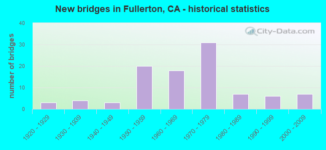
- New bridges - historical statistics
- 31920-1929
- 41930-1939
- 31940-1949
- 201950-1959
- 181960-1969
- 311970-1979
- 71980-1989
- 61990-1999
- 72000-2009

- Reconstructed bridges - Historical Statistics
- 11950-1959
- 21960-1969
- 51970-1979
- 21980-1989
- 31990-1999
- 92000-2009


- Bridge Condition - Deck
- 76.0%Good
- 20.0%Fair
- 4.0%Poor

- Bridge Condition - Superstructure
- 88.0%Good
- 10.0%Fair
- 2.0%Poor

- Bridge Condition - Substructure
- 94.0%Good
- 2.0%Satisfactory
- 4.0%Fair

- Bridge Condition - Channel
- 71.4%Excellent
- 28.6%Very good

- Bridge Condition - Culverts
- 53.3%Good
- 46.7%Satisfactory
Find on map >> Show street view
Structure Number: 55 028, Location: 12-ORA-091-1.23-ANA (Lat: 33.853725, Lng: -117.959472), Route carried "on" structure: State highway 91, Year Built: 1958, Year Reconstructed: 1995, Status: Open, Structure Length: 4.16m (13.65ft), Average Daily Traffic: 265,000 (year 2012), Truck Traffic: 6%, Average Future Daily Traffic: 295,000 (year 2040), Design Load: HS 20, Features Intersected: BROOKHURST STREET
Minimum Vertical Clearance: 30+ m (98+ ft), Kilometerpoint: 1.230, Lanes on structure: 9, Lanes under structure: 4, Base Highway Network: Yes (, Subroute: 1), Owner: State Highway Agency, Approaching Roadway Width: 42.7m (140.1ft), Skew: 10 degrees, Material/Design: Steel, Design/Construction: Stringer/Multi-beam, Number Of Spans In Main Unit: 4, Length of Maximum Span: 12.8m (42.0ft), Curb or Sidewalk Widths: Left: 0.6m (2.0ft), Right: 0.6m (2.0ft), Curb-To-Curb Width: 42.7m (140.1ft), Out-to-Out Width: 44.3m (145.3ft)
Condition: Deck: Good, Superstructure: Good, Substructure: Fair, Operating Rating: 54.1 metric tons, Method Used To Determine Operating Rating: Assigned rating based on Load Factor Design (LFD) reported in metric tons, Inventory Rating: 32.4 metric tons, Method Used To Determine Inventory Rating: Assigned rating based on Load Factor Design (LFD) reported in metric tons, Structural Evaluation: Somewhat better than minimum adequacy, Deck Geometry: Superior to present desirable criteria, Underclear: Meets minimum limits, Approach Roadway Alignment: Equal to present desirable criteria, Designated Inspection Frequency: Every 24 months, Inspection Date: December 2020, Deck Structure Type: Concrete Cast-file-Place
Find on map >> Show street view
Structure Number: 55 0287, Location: 12-ORA-091-0.72-FUL (Lat: 33.854478, Lng: -117.968164), Route carried "on" structure: State highway 91, Year Built: 1958, Year Reconstructed: 1995, Status: Open, Structure Length: 4.56m (14.96ft), Average Daily Traffic: 265,000 (year 2012), Truck Traffic: 6%, Average Future Daily Traffic: 295,000 (year 2040), Design Load: HS 20, Features Intersected: GILBERT STREET
Minimum Vertical Clearance: 30+ m (98+ ft), Kilometerpoint: 0.720, Lanes on structure: 11, Lanes under structure: 2, Base Highway Network: Yes (, Subroute: 1), Owner: State Highway Agency, Approaching Roadway Width: 50.0m (164.0ft), Skew: 12 degrees, Material/Design: Steel, Design/Construction: Stringer/Multi-beam, Number Of Spans In Main Unit: 3, Length of Maximum Span: 25.9m (85.0ft), Curb or Sidewalk Widths: Left: 0.6m (2.0ft), Right: 0.6m (2.0ft), Curb-To-Curb Width: 50.0m (164.0ft), Out-to-Out Width: 51.5m (169.0ft)
Condition: Deck: Good, Superstructure: Good, Substructure: Good, Operating Rating: 26.2 metric tons, Method Used To Determine Operating Rating: Load and Resistance Factor Rating (LRFR) rating reported by rating factor(RF) method using HL-93 loadings, Inventory Rating: 20.1 metric tons, Method Used To Determine Inventory Rating: Load and Resistance Factor Rating (LRFR) rating reported by rating factor(RF) method using HL-93 loadings, Structural Evaluation: Somewhat better than minimum adequacy, Deck Geometry: Superior to present desirable criteria, Underclear: Meets minimum limits, Approach Roadway Alignment: Equal to present desirable criteria, Designated Inspection Frequency: Every 24 months, Inspection Date: December 2020, Deck Structure Type: Concrete Cast-file-Place
Find on map >> Show street view
Structure Number: 55 0293L, Location: 12-ORA-091-R3.56L-FUL (Lat: 33.857311, Lng: -117.982878), Route carried "on" structure: State highway 91, Year Built: 1970, Status: Open, Structure Length: 22.34m (73.29ft), Average Daily Traffic: 134,000 (year 2012), Truck Traffic: 8%, Average Future Daily Traffic: 149,500 (year 2040), Design Load: HS 20+Mod, Features Intersected: UP RR, I 5, & CONNS
Minimum Vertical Clearance: 30+ m (98+ ft), Kilometerpoint: 3.560, Lanes on structure: 3, Lanes under structure: 10, Base Highway Network: Yes (, Subroute: 1), Owner: State Highway Agency, Approaching Roadway Width: 14.9m (48.9ft), Skew: 3 degrees, Material/Design: Prestressed concrete continuous, Design/Construction: Box Beam or Girders - Multiple, Number Of Spans In Main Unit: 5, Length of Maximum Span: 64.3m (211.0ft), Curb-To-Curb Width: 14.9m (48.9ft), Out-to-Out Width: 16.2m (53.1ft)
Condition: Deck: Fair, Superstructure: Good, Substructure: Good, Operating Rating: 54.1 metric tons, Method Used To Determine Operating Rating: Assigned rating based on Load Factor Design (LFD) reported in metric tons, Inventory Rating: 32.4 metric tons, Method Used To Determine Inventory Rating: Assigned rating based on Load Factor Design (LFD) reported in metric tons, Structural Evaluation: Better than present minimum criteria, Deck Geometry: Meets minimum limits, Underclear: High priority of corrective action, Approach Roadway Alignment: Equal to present desirable criteria, Designated Inspection Frequency: Every 24 months, Inspection Date: December 2020, Deck Structure Type: Concrete Cast-file-Place
Find on map >> Show street view
Structure Number: 55 0296F, Location: 12-ORA-091-R3.85L-FUL (Lat: 33.857275, Lng: -117.976544), Route carried "on" structure: Ramp State highway 91, Year Built: 1958, Year Reconstructed: 2000, Status: Open, Structure Length: 5.46m (17.91ft), Average Daily Traffic: 36,170 (year 2012), Truck Traffic: 7%, Average Future Daily Traffic: 39,800 (year 2040), Design Load: H 20, Features Intersected: MAGNOLIA AVE
Minimum Vertical Clearance: 30+ m (98+ ft), Kilometerpoint: 3.850, Lanes on structure: 2, Lanes under structure: 5, Base Highway Network: Yes (, Subroute: 1), Owner: State Highway Agency, Approaching Roadway Width: 12.5m (41.0ft), Skew: 1 degrees, Material/Design: Steel, Design/Construction: Stringer/Multi-beam, Number Of Spans In Main Unit: 3, Length of Maximum Span: 32.2m (105.6ft), Curb or Sidewalk Widths: Left: 0.6m (2.0ft), Right: 0.6m (2.0ft), Curb-To-Curb Width: 12.5m (41.0ft), Out-to-Out Width: 13.5m (44.3ft)
Condition: Deck: Good, Superstructure: Good, Substructure: Good, Operating Rating: 55.7 metric tons, Method Used To Determine Operating Rating: Load Factor (LF), Inventory Rating: 33.4 metric tons, Method Used To Determine Inventory Rating: Load Factor (LF), Structural Evaluation: Better than present minimum criteria, Deck Geometry: Superior to present desirable criteria, Underclear: High priority of corrective action, Approach Roadway Alignment: Equal to present desirable criteria, Designated Inspection Frequency: Every 24 months, Inspection Date: December 2020, Deck Structure Type: Concrete Cast-file-Place
Find on map >> Show street view
Structure Number: 55 0296L, Location: 12-ORA-091-R3.85L-FUL (Lat: 33.857525, Lng: -117.976500), Route carried "on" structure: State highway 91, Year Built: 1970, Year Reconstructed: 2000, Status: Open, Structure Length: 4.61m (15.12ft), Average Daily Traffic: 132,500 (year 2012), Truck Traffic: 6%, Average Future Daily Traffic: 147,500 (year 2040), Design Load: HS 20, Features Intersected: MAGNOLIA AVE
Minimum Vertical Clearance: 30+ m (98+ ft), Kilometerpoint: 3.850, Lanes on structure: 3, Lanes under structure: 6, Base Highway Network: Yes (, Subroute: 1), Owner: State Highway Agency, Approaching Roadway Width: 19.3m (63.3ft), Skew: 2 degrees, Material/Design: Prestressed concrete, Design/Construction: Box Beam or Girders - Multiple, Number Of Spans In Main Unit: 1, Length of Maximum Span: 45.7m (149.9ft), Curb-To-Curb Width: 19.3m (63.3ft), Out-to-Out Width: 20.3m (66.6ft)
Condition: Deck: Good, Superstructure: Good, Substructure: Good, Operating Rating: 54.1 metric tons, Method Used To Determine Operating Rating: Assigned rating based on Load Factor Design (LFD) reported in metric tons, Inventory Rating: 32.4 metric tons, Method Used To Determine Inventory Rating: Assigned rating based on Load Factor Design (LFD) reported in metric tons, Structural Evaluation: Better than present minimum criteria, Deck Geometry: Superior to present desirable criteria, Underclear: High priority of corrective action, Approach Roadway Alignment: Equal to present desirable criteria, Designated Inspection Frequency: Every 24 months, Inspection Date: December 2020, Deck Structure Type: Concrete Cast-file-Place
Find on map >> Show street view
Structure Number: 55 0296R, Location: 12-ORA-091-R3.85R-FUL (Lat: 33.856839, Lng: -117.976631), Route carried "on" structure: State highway 91, Year Built: 1958, Year Reconstructed: 2000, Status: Open, Structure Length: 5.31m (17.42ft), Average Daily Traffic: 132,500 (year 2012), Truck Traffic: 6%, Average Future Daily Traffic: 147,500 (year 2040), Design Load: HS 20, Features Intersected: MAGNOLIA AVE
Minimum Vertical Clearance: 30+ m (98+ ft), Kilometerpoint: 3.850, Lanes on structure: 5, Lanes under structure: 5, Base Highway Network: Yes (, Subroute: 1), Owner: State Highway Agency, Approaching Roadway Width: 24.6m (80.7ft), Skew: 20 degrees, Material/Design: Steel, Design/Construction: Stringer/Multi-beam, Number Of Spans In Main Unit: 3, Length of Maximum Span: 31.4m (103.0ft), Curb-To-Curb Width: 24.6m (80.7ft), Out-to-Out Width: 25.6m (84.0ft)
Condition: Deck: Good, Superstructure: Good, Substructure: Good, Operating Rating: 61.9 metric tons, Method Used To Determine Operating Rating: Load Factor (LF), Inventory Rating: 36.9 metric tons, Method Used To Determine Inventory Rating: Load Factor (LF), Structural Evaluation: Better than present minimum criteria, Deck Geometry: Better than present minimum criteria, Underclear: High priority of corrective action, Approach Roadway Alignment: Better than present minimum criteria, Designated Inspection Frequency: Every 24 months, Inspection Date: December 2020, Deck Structure Type: Concrete Cast-file-Place
Find on map >> Show street view
Structure Number: 55 0456, Location: 12-ORA-057-17.30-FUL (Lat: 33.873900, Lng: -117.880117), Route carried "on" structure: State highway 57, Year Built: 1969, Year Reconstructed: 2013, Status: Open, Structure Length: 4.63m (15.19ft), Average Daily Traffic: 271,000 (year 2010), Average Future Daily Traffic: 359,000 (year 2040), Design Load: HS 20, Features Intersected: CHAPMAN AVE
Minimum Vertical Clearance: 30+ m (98+ ft), Kilometerpoint: 17.300, Lanes on structure: 12, Lanes under structure: 6, Base Highway Network: Yes (, Subroute: 1), Owner: State Highway Agency, Approaching Roadway Width: 50.5m (165.7ft), Skew: 31 degrees, Material/Design: Prestressed concrete, Design/Construction: Box Beam or Girders - Multiple, Number Of Spans In Main Unit: 1, Length of Maximum Span: 45.7m (149.9ft), Curb-To-Curb Width: 50.5m (165.7ft), Out-to-Out Width: 51.4m (168.6ft)
Condition: Deck: Good, Superstructure: Good, Substructure: Good, Operating Rating: 54.1 metric tons, Method Used To Determine Operating Rating: Assigned rating based on Load Factor Design (LFD) reported in metric tons, Inventory Rating: 32.4 metric tons, Method Used To Determine Inventory Rating: Assigned rating based on Load Factor Design (LFD) reported in metric tons, Structural Evaluation: Better than present minimum criteria, Deck Geometry: Better than present minimum criteria, Underclear: Somewhat better than minimum adequacy, Approach Roadway Alignment: Equal to present desirable criteria, Designated Inspection Frequency: Every 24 months, Inspection Date: May 2020, Deck Structure Type: Concrete Cast-file-Place
Find on map >> Show street view
Structure Number: 55 0464, Location: 12-ORA-057-17.57-FUL (Lat: 33.877925, Lng: -117.880183), Route carried "on" structure: State highway 57, Year Built: 1969, Year Reconstructed: 2013, Status: Open, Structure Length: 4.63m (15.19ft), Average Daily Traffic: 248,000 (year 2010), Average Future Daily Traffic: 327,000 (year 2040), Design Load: HS 20, Features Intersected: NUTWOOD AVE
Minimum Vertical Clearance: 30+ m (98+ ft), Kilometerpoint: 17.570, Lanes on structure: 11, Lanes under structure: 7, Base Highway Network: Yes (, Subroute: 1), Owner: State Highway Agency, Approaching Roadway Width: 43.9m (144.0ft), Skew: 30 degrees, Material/Design: Prestressed concrete, Design/Construction: Box Beam or Girders - Multiple, Number Of Spans In Main Unit: 1, Length of Maximum Span: 45.7m (149.9ft), Curb-To-Curb Width: 43.9m (144.0ft), Out-to-Out Width: 51.3m (168.3ft)
Condition: Deck: Good, Superstructure: Good, Substructure: Good, Operating Rating: 54.1 metric tons, Method Used To Determine Operating Rating: Assigned rating based on Load Factor Design (LFD) reported in metric tons, Inventory Rating: 32.4 metric tons, Method Used To Determine Inventory Rating: Assigned rating based on Load Factor Design (LFD) reported in metric tons, Structural Evaluation: Better than present minimum criteria, Deck Geometry: Meets minimum limits, Underclear: Somewhat better than minimum adequacy, Approach Roadway Alignment: Equal to present desirable criteria, Designated Inspection Frequency: Every 24 months, Inspection Date: June 2020, Deck Structure Type: Concrete Cast-file-Place, Wearing Surface/Protective System: Wearing Surface: Integral Concrete
Find on map >> Show street view
Structure Number: 55 0465, Location: 12-ORA-057-18.85-FUL (Lat: 33.896528, Lng: -117.880656), Route carried "on" structure: State highway 57, Year Built: 1970, Year Reconstructed: 2013, Status: Open, Structure Length: 4.79m (15.72ft), Average Daily Traffic: 245,000 (year 2010), Truck Traffic: 8%, Average Future Daily Traffic: 310,000 (year 2040), Design Load: HS 20, Features Intersected: BASTANCHURY ROAD
Minimum Vertical Clearance: 30+ m (98+ ft), Kilometerpoint: 18.850, Lanes on structure: 11, Lanes under structure: 4, Base Highway Network: Yes (, Subroute: 1), Owner: State Highway Agency, Approaching Roadway Width: 51.4m (168.6ft), Skew: 31 degrees, Material/Design: Prestressed concrete, Design/Construction: Box Beam or Girders - Multiple, Number Of Spans In Main Unit: 1, Length of Maximum Span: 47.9m (157.2ft), Curb-To-Curb Width: 51.4m (168.6ft), Out-to-Out Width: 52.9m (173.6ft)
Condition: Deck: Fair, Superstructure: Good, Substructure: Good, Operating Rating: 54.1 metric tons, Method Used To Determine Operating Rating: Assigned rating based on Load Factor Design (LFD) reported in metric tons, Inventory Rating: 32.4 metric tons, Method Used To Determine Inventory Rating: Assigned rating based on Load Factor Design (LFD) reported in metric tons, Structural Evaluation: Better than present minimum criteria, Deck Geometry: Superior to present desirable criteria, Underclear: Equal to present minimum criteria, Approach Roadway Alignment: Equal to present desirable criteria, Designated Inspection Frequency: Every 24 months, Inspection Date: June 2020, Deck Structure Type: Concrete Cast-file-Place
Find on map >> Show street view
Structure Number: 55 0466, Location: 12-ORA-057-19.58-FUL (Lat: 33.907075, Lng: -117.881653), Route carried "on" structure: State highway 57, Year Built: 1970, Year Reconstructed: 2013, Status: Open, Structure Length: 4.63m (15.19ft), Average Daily Traffic: 245,000 (year 2010), Truck Traffic: 8%, Average Future Daily Traffic: 310,000 (year 2040), Design Load: HS 20, Features Intersected: ASSOCIATED ROAD
Minimum Vertical Clearance: 30+ m (98+ ft), Kilometerpoint: 19.580, Lanes on structure: 11, Lanes under structure: 4, Base Highway Network: Yes (, Subroute: 1), Owner: State Highway Agency, Approaching Roadway Width: 47.9m (157.2ft), Skew: 32 degrees, Material/Design: Prestressed concrete, Design/Construction: Box Beam or Girders - Multiple, Number Of Spans In Main Unit: 1, Length of Maximum Span: 46.3m (151.9ft), Curb-To-Curb Width: 47.6m (156.2ft), Out-to-Out Width: 58.9m (193.2ft)
Condition: Deck: Fair, Superstructure: Good, Substructure: Good, Operating Rating: 54.1 metric tons, Method Used To Determine Operating Rating: Assigned rating based on Load Factor Design (LFD) reported in metric tons, Inventory Rating: 32.4 metric tons, Method Used To Determine Inventory Rating: Assigned rating based on Load Factor Design (LFD) reported in metric tons, Structural Evaluation: Better than present minimum criteria, Deck Geometry: Better than present minimum criteria, Underclear: Equal to present minimum criteria, Approach Roadway Alignment: Equal to present desirable criteria, Designated Inspection Frequency: Every 24 months, Inspection Date: June 2020, Deck Structure Type: Concrete Cast-file-Place
Find on map >> Show street view
Structure Number: 55 0468, Location: 12-ORA-057-18.34-FUL (Lat: 33.888914, Lng: -117.880989), Route carried "on" structure: City street M009, Year Built: 1970, Status: Open, Structure Length: 7.19m (23.59ft), Average Daily Traffic: 20,000 (year 2010), Truck Traffic: 3%, Average Future Daily Traffic: 23,126 (year 2040), Design Load: HS 20, Features Intersected: STATE ROUTE 57, Facility Carried by Structure: YORBA LINDA BLVD
Minimum Vertical Clearance: 30+ m (98+ ft), Kilometerpoint: 0.000, Lanes on structure: 6, Lanes under structure: 13, Owner: State Highway Agency, Approaching Roadway Width: 20.7m (67.9ft), Skew: 20 degrees, Material/Design: Concrete continuous, Design/Construction: Box Beam or Girders - Multiple, Number Of Spans In Main Unit: 2, Length of Maximum Span: 36.6m (120.1ft), Curb or Sidewalk Widths: Left: 2.1m (6.9ft), Right: 2.1m (6.9ft), Curb-To-Curb Width: 20.7m (67.9ft), Out-to-Out Width: 30.5m (100.1ft)
Condition: Deck: Good, Superstructure: Good, Substructure: Good, Operating Rating: 42.1 metric tons, Method Used To Determine Operating Rating: Load and Resistance Factor Rating (LRFR) rating reported by rating factor(RF) method using HL-93 loadings, Inventory Rating: 32.4 metric tons, Method Used To Determine Inventory Rating: Load and Resistance Factor Rating (LRFR) rating reported by rating factor(RF) method using HL-93 loadings, Structural Evaluation: Better than present minimum criteria, Deck Geometry: High priority of replacement, Underclear: High priority of corrective action, Approach Roadway Alignment: Equal to present desirable criteria, Designated Inspection Frequency: Every 24 months, Inspection Date: June 2020, Deck Structure Type: Concrete Cast-file-Place
Find on map >> Show street view
Structure Number: 55 0472S, Location: 12-ORA-091-R3.64R-FUL (Lat: 33.855917, Lng: -117.980494), Route carried "on" structure: Ramp State highway 91, Year Built: 1970, Status: Open, Structure Length: 14.17m (46.49ft), Average Daily Traffic: 10,000 (year 2012), Truck Traffic: 7%, Average Future Daily Traffic: 11,000 (year 2040), Design Load: HS 20+Mod, Features Intersected: UP RR, S5-MAGNOLIA AV OF
Minimum Vertical Clearance: 30+ m (98+ ft), Kilometerpoint: 3.640, Lanes on structure: 1, Lanes under structure: 1, Base Highway Network: Yes, Owner: State Highway Agency, Approaching Roadway Width: 7.3m (24.0ft), Skew: 9 degrees, Material/Design: Concrete continuous, Design/Construction: Box Beam or Girders - Multiple, Number Of Spans In Main Unit: 5, Length of Maximum Span: 39.3m (128.9ft), Curb-To-Curb Width: 7.3m (24.0ft), Out-to-Out Width: 7.9m (25.9ft)
Condition: Deck: Fair, Superstructure: Good, Substructure: Good, Operating Rating: 54.1 metric tons, Method Used To Determine Operating Rating: Assigned rating based on Load Factor Design (LFD) reported in metric tons, Inventory Rating: 32.4 metric tons, Method Used To Determine Inventory Rating: Assigned rating based on Load Factor Design (LFD) reported in metric tons, Structural Evaluation: Better than present minimum criteria, Deck Geometry: Better than present minimum criteria, Underclear: Equal to present minimum criteria, Approach Roadway Alignment: Equal to present desirable criteria, Designated Inspection Frequency: Every 24 months, Inspection Date: December 2020, Deck Structure Type: Concrete Cast-file-Place
Find on map >> Show street view
Structure Number: 55 0483, Location: 12-ORA-057-19.33-FUL (Lat: 33.903369, Lng: -117.880808), Route carried "on" structure: State highway 57, Year Built: 1970, Year Reconstructed: 2013, Status: Open, Structure Length: 4.05m (13.29ft), Average Daily Traffic: 245,000 (year 2010), Truck Traffic: 8%, Average Future Daily Traffic: 310,000 (year 2040), Design Load: HS 20, Features Intersected: ROLLING HILLS DR
Minimum Vertical Clearance: 30+ m (98+ ft), Kilometerpoint: 19.330, Lanes on structure: 11, Lanes under structure: 2, Base Highway Network: Yes (, Subroute: 1), Owner: State Highway Agency, Approaching Roadway Width: 55.1m (180.8ft), Skew: 30 degrees, Material/Design: Prestressed concrete, Design/Construction: Box Beam or Girders - Multiple, Number Of Spans In Main Unit: 1, Length of Maximum Span: 39.9m (130.9ft), Curb-To-Curb Width: 55.1m (180.8ft), Out-to-Out Width: 56.7m (186.0ft)
Condition: Deck: Fair, Superstructure: Good, Substructure: Good, Operating Rating: 54.1 metric tons, Method Used To Determine Operating Rating: Assigned rating based on Load Factor Design (LFD) reported in metric tons, Inventory Rating: 32.4 metric tons, Method Used To Determine Inventory Rating: Assigned rating based on Load Factor Design (LFD) reported in metric tons, Structural Evaluation: Better than present minimum criteria, Deck Geometry: Superior to present desirable criteria, Underclear: Equal to present minimum criteria, Approach Roadway Alignment: Equal to present desirable criteria, Designated Inspection Frequency: Every 24 months, Inspection Date: June 2020, Deck Structure Type: Concrete Cast-file-Place
Find on map >> Show street view
Structure Number: 55 0503G, Location: 12-ORA-091-R3.61R-FUL (Lat: 33.856064, Lng: -117.980781), Route carried "on" structure: Ramp State highway 91, Year Built: 1970, Status: Open, Structure Length: 14.26m (46.78ft), Average Daily Traffic: 41,200 (year 2012), Truck Traffic: 7%, Average Future Daily Traffic: 45,320 (year 2040), Design Load: HS 20+Mod, Features Intersected: UP RR,S5-MAGNOLIA AV OFF
Minimum Vertical Clearance: 30+ m (98+ ft), Kilometerpoint: 3.610, Lanes on structure: 2, Lanes under structure: 1, Base Highway Network: Yes, Owner: State Highway Agency, Approaching Roadway Width: 11.9m (39.0ft), Skew: 9 degrees, Material/Design: Concrete continuous, Design/Construction: Box Beam or Girders - Multiple, Number Of Spans In Main Unit: 4, Length of Maximum Span: 39.9m (130.9ft), Curb-To-Curb Width: 11.9m (39.0ft), Out-to-Out Width: 12.5m (41.0ft)
Condition: Deck: Good, Superstructure: Good, Substructure: Good, Operating Rating: 54.1 metric tons, Method Used To Determine Operating Rating: Assigned rating based on Load Factor Design (LFD) reported in metric tons, Inventory Rating: 32.4 metric tons, Method Used To Determine Inventory Rating: Assigned rating based on Load Factor Design (LFD) reported in metric tons, Structural Evaluation: Better than present minimum criteria, Deck Geometry: Superior to present desirable criteria, Underclear: Superior to present desirable criteria, Approach Roadway Alignment: Equal to present desirable criteria, Designated Inspection Frequency: Every 24 months, Inspection Date: December 2020, Deck Structure Type: Concrete Cast-file-Place
Find on map >> Show street view
Structure Number: 55 0528, Location: 12-ORA-057-19.66-FUL (Lat: 33.907742, Lng: -117.882083), Route carried "on" structure: State highway 57, Year Built: 1970, Year Reconstructed: 2013, Status: Open, Structure Length: 3.15m (10.33ft), Average Daily Traffic: 245,000 (year 2010), Truck Traffic: 8%, Average Future Daily Traffic: 310,000 (year 2040), Features Intersected: LOFTUS DIVERSION CH
Minimum Vertical Clearance: 30+ m (98+ ft), Kilometerpoint: 19.660, Lanes on structure: 12, Base Highway Network: Yes (, Subroute: 1), Owner: State Highway Agency, Approaching Roadway Width: 72.2m (236.9ft), Skew: 34 degrees, Material/Design: Concrete continuous, Design/Construction: Culvert, Number Of Spans In Main Unit: 5, Length of Maximum Span: 5.2m (17.1ft), Curb-To-Curb Width: 72.2m (236.9ft), Out-to-Out Width: 73.2m (240.2ft)
Condition: Channel: Very good, Culverts: Good, Operating Rating: 54.1 metric tons, Method Used To Determine Operating Rating: Field evaluation and documented engineering judgment, Inventory Rating: 32.4 metric tons, Method Used To Determine Inventory Rating: Field evaluation and documented engineering judgment, Structural Evaluation: Better than present minimum criteria, Deck Geometry: Superior to present desirable criteria, Waterway Adequacy: Equal to present desirable criteria, Approach Roadway Alignment: Equal to present desirable criteria, Designated Inspection Frequency: Every 24 months, Inspection Date: June 2020
Find on map >> Show street view
Structure Number: 55 0840S, Location: 12-ORA-005-36.44-ANA (Lat: 33.805075, Lng: -117.903303), Route carried "on" structure: Ramp Interstate 5, Year Built: 2000, Status: Open, Structure Length: 11.28m (37.01ft), Average Daily Traffic: 5,668 (year 2015), Truck Traffic: 3%, Average Future Daily Traffic: 6,036 (year 2044), Design Load: HS 20+Mod, Features Intersected: DISNEY WAY
Minimum Vertical Clearance: 30+ m (98+ ft), Kilometerpoint: 36.440, Lanes on structure: 2, Lanes under structure: 2, Owner: State Highway Agency, Approaching Roadway Width: 11.0m (36.1ft), Skew: 9 degrees, Material/Design: Prestressed concrete continuous, Design/Construction: Box Beam or Girders - Single/Spread, Number Of Spans In Main Unit: 3, Length of Maximum Span: 45.7m (149.9ft), Curb-To-Curb Width: 11.0m (36.1ft), Out-to-Out Width: 12.0m (39.4ft)
Condition: Deck: Good, Superstructure: Good, Substructure: Good, Operating Rating: 54.1 metric tons, Method Used To Determine Operating Rating: Assigned rating based on Load Factor Design (LFD) reported in metric tons, Inventory Rating: 32.4 metric tons, Method Used To Determine Inventory Rating: Assigned rating based on Load Factor Design (LFD) reported in metric tons, Structural Evaluation: Better than present minimum criteria, Deck Geometry: Better than present minimum criteria, Underclear: High priority of corrective action, Approach Roadway Alignment: Equal to present desirable criteria, Designated Inspection Frequency: Every 24 months, Inspection Date: January 2022, Deck Structure Type: Concrete Cast-file-Place
Find on map >> Show street view
Structure Number: 55 0849E, Location: 12-ORA-091-5.60-FUL (Lat: 33.852761, Lng: -117.882728), Route carried "on" structure: Ramp State highway 91, Year Built: 2000, Status: Open, Structure Length: 122.35m (401.41ft), Average Daily Traffic: 20,000 (year 2012), Truck Traffic: 9%, Average Future Daily Traffic: 22,000 (year 2040), Design Load: HS 20+Mod, Features Intersected: SR 57, 91 & LOCAL STRTS
Minimum Vertical Clearance: 30+ m (98+ ft), Kilometerpoint: 5.600, Lanes on structure: 2, Lanes under structure: 27, Base Highway Network: Yes, Owner: State Highway Agency, Approaching Roadway Width: 16.5m (54.1ft), Skew: 39 degrees, Material/Design: Prestressed concrete continuous, Design/Construction: Box Beam or Girders - Multiple, Number Of Spans In Main Unit: 25, Length of Maximum Span: 80.2m (263.1ft), Curb-To-Curb Width: 16.5m (54.1ft), Out-to-Out Width: 18.1m (59.4ft)
Condition: Deck: Good, Superstructure: Good, Substructure: Good, Operating Rating: 54.1 metric tons, Method Used To Determine Operating Rating: Assigned rating based on Load Factor Design (LFD) reported in metric tons, Inventory Rating: 32.4 metric tons, Method Used To Determine Inventory Rating: Assigned rating based on Load Factor Design (LFD) reported in metric tons, Structural Evaluation: Better than present minimum criteria, Deck Geometry: Superior to present desirable criteria, Underclear: Meets minimum limits, Approach Roadway Alignment: Equal to present minimum criteria, Designated Inspection Frequency: Every 24 months, Inspection Date: November 2021, Deck Structure Type: Concrete Cast-file-Place
Find on map >> Show street view
Structure Number: 55C0147, Location: 0.1 MI N/O VALENCIA DR (Lat: 33.868372, Lng: -117.959297), Route carried "on" structure: City street , Year Built: 1958, Year Reconstructed: 1976, Status: Open, Structure Length: 1.01m (3.31ft), Average Daily Traffic: 35,400 (year 2016), Truck Traffic: 1%, Average Future Daily Traffic: 46,252 (year 2037), Design Load: HS 20, Features Intersected: FULLERTON CREEK CHANNEL, Facility Carried by Structure: BROOKHURST RD
Minimum Vertical Clearance: 30+ m (98+ ft), Kilometerpoint: 0.000, Lanes on structure: 4, Owner: City or Municipal Highway Agency, Approaching Roadway Width: 19.4m (63.6ft), Material/Design: Prestressed concrete, Design/Construction: Slab, Number Of Spans In Main Unit: 1, Length of Maximum Span: 9.8m (32.2ft), Curb or Sidewalk Widths: Left: 2.1m (6.9ft), Right: 2.9m (9.5ft), Curb-To-Curb Width: 19.4m (63.6ft), Out-to-Out Width: 24.4m (80.1ft)
Condition: Deck: Good, Superstructure: Good, Substructure: Good, Channel: Excellent, Operating Rating: 72.3 metric tons, Method Used To Determine Operating Rating: Load Factor (LF), Inventory Rating: 32.4 metric tons, Method Used To Determine Inventory Rating: Load Factor (LF), Structural Evaluation: Better than present minimum criteria, Deck Geometry: Better than present minimum criteria, Waterway Adequacy: Superior to present desirable criteria, Approach Roadway Alignment: Equal to present desirable criteria, Designated Inspection Frequency: Every 48 months, Inspection Date: September 2019, Deck Structure Type: Concrete Precast Panels, Wearing Surface/Protective System: Wearing Surface: Bituminous
Find on map >> Show street view
Structure Number: 55C022, Location: 0.8 MI N OF ALICIA PKWY (Lat: 33.602875, Lng: -117.702481), Route carried "on" structure: City street , Year Built: 1966, Year Reconstructed: 1978, Status: Open, Structure Length: 0.79m (2.59ft), Average Daily Traffic: 32,800 (year 2019), Truck Traffic: 1%, Average Future Daily Traffic: 65,609 (year 2038), Design Load: HS 20, Features Intersected: ALISO CREEK, Facility Carried by Structure: PASEO DE VALENCIA
Minimum Vertical Clearance: 30+ m (98+ ft), Kilometerpoint: 0.000, Lanes on structure: 5, Owner: City or Municipal Highway Agency, Approaching Roadway Width: 25.6m (84.0ft), Skew: 29 degrees, Material/Design: Concrete, Design/Construction: Culvert, Number Of Spans In Main Unit: 2, Length of Maximum Span: 3.7m (12.1ft), Curb or Sidewalk Widths: Left: 0.2m (0.7ft), Right: 3.4m (11.2ft), Curb-To-Curb Width: 25.6m (84.0ft), Out-to-Out Width: 41.2m (135.2ft)
Condition: Channel: Very good, Culverts: Satisfactory, Operating Rating: 40.5 metric tons, Method Used To Determine Operating Rating: Field evaluation and documented engineering judgment, Inventory Rating: 24.3 metric tons, Method Used To Determine Inventory Rating: Field evaluation and documented engineering judgment, Structural Evaluation: Equal to present minimum criteria, Deck Geometry: Superior to present desirable criteria, Waterway Adequacy: Equal to present desirable criteria, Approach Roadway Alignment: Equal to present desirable criteria, Designated Inspection Frequency: Every 24 months, Inspection Date: May 2021
Find on map >> Show street view
Structure Number: 55C0224, Location: 100' S/O MALVERN AVE (Lat: 33.875442, Lng: -117.950669), Route carried "on" structure: City street , Year Built: 1940, Status: Open, Structure Length: 1.34m (4.40ft), Average Daily Traffic: 8,000 (year 2017), Truck Traffic: 1%, Average Future Daily Traffic: 14,300 (year 2041), Features Intersected: BREA CREEK CHANNEL, Facility Carried by Structure: BASQUE AVE
Minimum Vertical Clearance: 30+ m (98+ ft), Kilometerpoint: 0.000, Lanes on structure: 3, Owner: City or Municipal Highway Agency, Approaching Roadway Width: 11.0m (36.1ft), Material/Design: Concrete, Design/Construction: Slab, Number Of Spans In Main Unit: 1, Length of Maximum Span: 13.4m (44.0ft), Curb or Sidewalk Widths: Left: 1.5m (4.9ft), Right: 1.5m (4.9ft), Curb-To-Curb Width: 12.2m (40.0ft), Out-to-Out Width: 12.8m (42.0ft)
Condition: Deck: Fair, Superstructure: Fair, Substructure: Good, Channel: Very good, Operating Rating: 24.9 metric tons, Method Used To Determine Operating Rating: Field evaluation and documented engineering judgment, Inventory Rating: 14.9 metric tons, Method Used To Determine Inventory Rating: Field evaluation and documented engineering judgment, Structural Evaluation: High priority of corrective action, Deck Geometry: Meets minimum limits, Waterway Adequacy: Equal to present desirable criteria, Approach Roadway Alignment: Equal to present desirable criteria, Designated Inspection Frequency: Every 24 months, Inspection Date: September 2021, Deck Structure Type: Concrete Cast-file-Place
Find on map >> Show street view
Structure Number: 55C0225, Location: 50' N/O CHAPMAN AVE (Lat: 33.873956, Lng: -117.933044), Route carried "on" structure: City street , Year Built: 1940, Year Reconstructed: 1970, Status: Open, Structure Length: 1.46m (4.79ft), Average Daily Traffic: 4,653 (year 2018), Truck Traffic: 1%, Average Future Daily Traffic: 7,000 (year 2041), Features Intersected: BREA CREEK CHANNEL, Facility Carried by Structure: RICHMAN AVE
Minimum Vertical Clearance: 30+ m (98+ ft), Kilometerpoint: 0.000, Lanes on structure: 2, Owner: City or Municipal Highway Agency, Approaching Roadway Width: 11.0m (36.1ft), Skew: 2 degrees, Material/Design: Concrete, Design/Construction: Slab, Number Of Spans In Main Unit: 1, Length of Maximum Span: 14.6m (47.9ft), Curb or Sidewalk Widths: Left: 1.5m (4.9ft), Right: 1.2m (3.9ft), Curb-To-Curb Width: 11.0m (36.1ft), Out-to-Out Width: 14.5m (47.6ft)
Condition: Deck: Good, Superstructure: Good, Substructure: Good, Channel: Very good, Operating Rating: 24.6 metric tons, Method Used To Determine Operating Rating: Field evaluation and documented engineering judgment, Inventory Rating: 14.6 metric tons, Method Used To Determine Inventory Rating: Field evaluation and documented engineering judgment, Structural Evaluation: Meets minimum limits, Deck Geometry: Somewhat better than minimum adequacy, Waterway Adequacy: Equal to present desirable criteria, Approach Roadway Alignment: Equal to present desirable criteria, Designated Inspection Frequency: Every 24 months, Inspection Date: September 2021, Deck Structure Type: Concrete Cast-file-Place, Wearing Surface/Protective System: Wearing Surface: Bituminous
Find on map >> Show street view
Structure Number: 55C0226, Location: 50' N/O CHAPMAN AVE (Lat: 33.873967, Lng: -117.930831), Route carried "on" structure: City street , Year Built: 1922, Status: Open, Structure Length: 1.19m (3.90ft), Average Daily Traffic: 1,556 (year 2018), Truck Traffic: 1%, Average Future Daily Traffic: 2,600 (year 2041), Features Intersected: BREA CREEK CHANNEL, Facility Carried by Structure: FORD AVE
Minimum Vertical Clearance: 30+ m (98+ ft), Kilometerpoint: 0.000, Lanes on structure: 2, Owner: City or Municipal Highway Agency, Approaching Roadway Width: 9.1m (29.9ft), Material/Design: Concrete, Design/Construction: Slab, Number Of Spans In Main Unit: 1, Length of Maximum Span: 11.3m (37.1ft), Curb or Sidewalk Widths: Left: 1.2m (3.9ft), Right: 1.2m (3.9ft), Curb-To-Curb Width: 9.1m (29.9ft), Out-to-Out Width: 12.5m (41.0ft)
Condition: Deck: Good, Superstructure: Good, Substructure: Good, Channel: Very good, Operating Rating: 25.6 metric tons, Method Used To Determine Operating Rating: Field evaluation and documented engineering judgment, Inventory Rating: 15.2 metric tons, Method Used To Determine Inventory Rating: Field evaluation and documented engineering judgment, Structural Evaluation: Meets minimum limits, Deck Geometry: Somewhat better than minimum adequacy, Waterway Adequacy: Equal to present desirable criteria, Approach Roadway Alignment: Equal to present desirable criteria, Designated Inspection Frequency: Every 24 months, Inspection Date: September 2021, Deck Structure Type: Concrete Cast-file-Place, Wearing Surface/Protective System: Wearing Surface: Bituminous
Find on map >> Show street view
Structure Number: 55C0227, Location: 50' N/O CHAPMAN AVE (Lat: 33.873972, Lng: -117.928664), Route carried "on" structure: City street , Year Built: 1922, Status: Open, Structure Length: 1.19m (3.90ft), Average Daily Traffic: 8,500 (year 2018), Truck Traffic: 1%, Average Future Daily Traffic: 8,500 (year 2041), Features Intersected: BREA CREEK CHANNEL, Facility Carried by Structure: HIGHLAND AVE
Minimum Vertical Clearance: 30+ m (98+ ft), Kilometerpoint: 0.000, Lanes on structure: 2, Owner: City or Municipal Highway Agency, Approaching Roadway Width: 9.1m (29.9ft), Material/Design: Concrete, Design/Construction: Slab, Number Of Spans In Main Unit: 1, Length of Maximum Span: 11.3m (37.1ft), Curb or Sidewalk Widths: Left: 1.2m (3.9ft), Right: 1.2m (3.9ft), Curb-To-Curb Width: 9.1m (29.9ft), Out-to-Out Width: 12.5m (41.0ft)
Condition: Deck: Good, Superstructure: Good, Substructure: Good, Channel: Excellent, Operating Rating: 25.3 metric tons, Method Used To Determine Operating Rating: Field evaluation and documented engineering judgment, Inventory Rating: 15.2 metric tons, Method Used To Determine Inventory Rating: Field evaluation and documented engineering judgment, Structural Evaluation: High priority of corrective action, Deck Geometry: High priority of corrective action, Waterway Adequacy: Superior to present desirable criteria, Approach Roadway Alignment: Equal to present desirable criteria, Designated Inspection Frequency: Every 24 months, Inspection Date: September 2021, Deck Structure Type: Concrete Cast-file-Place, Wearing Surface/Protective System: Wearing Surface: Bituminous
Find on map >> Show street view
Structure Number: 55C0228, Location: 50' N/O CHAPMAN AVE (Lat: 33.874150, Lng: -117.926500), Route carried "on" structure: City street , Year Built: 1934, Status: Open, Structure Length: 1.46m (4.79ft), Average Daily Traffic: 3,102 (year 2018), Truck Traffic: 1%, Average Future Daily Traffic: 4,800 (year 2041), Features Intersected: BREA CREEK CHANNEL, Facility Carried by Structure: MALDEN AVE
Minimum Vertical Clearance: 30+ m (98+ ft), Kilometerpoint: 0.000, Lanes on structure: 2, Owner: City or Municipal Highway Agency, Approaching Roadway Width: 9.1m (29.9ft), Skew: 2 degrees, Material/Design: Concrete, Design/Construction: Slab, Number Of Spans In Main Unit: 1, Length of Maximum Span: 14.0m (45.9ft), Curb or Sidewalk Widths: Left: 1.3m (4.3ft), Right: 1.3m (4.3ft), Curb-To-Curb Width: 9.1m (29.9ft), Out-to-Out Width: 12.5m (41.0ft)
Condition: Deck: Good, Superstructure: Good, Substructure: Good, Channel: Excellent, Operating Rating: 24.6 metric tons, Method Used To Determine Operating Rating: Field evaluation and documented engineering judgment, Inventory Rating: 14.9 metric tons, Method Used To Determine Inventory Rating: Field evaluation and documented engineering judgment, Structural Evaluation: Meets minimum limits, Deck Geometry: Meets minimum limits, Waterway Adequacy: Superior to present desirable criteria, Approach Roadway Alignment: Equal to present desirable criteria, Designated Inspection Frequency: Every 24 months, Inspection Date: September 2021, Deck Structure Type: Concrete Cast-file-Place, Wearing Surface/Protective System: Wearing Surface: Bituminous
Find on map >> Show street view
Structure Number: 55C0229, Location: 0.1 MI E/O HARBOR BLVD (Lat: 33.877392, Lng: -117.922144), Route carried "on" structure: City street , Year Built: 1939, Status: Open, Structure Length: 1.10m (3.61ft), Average Daily Traffic: 2,000 (year 2018), Truck Traffic: 1%, Average Future Daily Traffic: 4,303 (year 2042), Features Intersected: BREA CREEK CHANNEL, Facility Carried by Structure: UNION AVE
Minimum Vertical Clearance: 30+ m (98+ ft), Kilometerpoint: 0.000, Lanes on structure: 2, Owner: City or Municipal Highway Agency, Approaching Roadway Width: 11.0m (36.1ft), Skew: 3 degrees, Material/Design: Concrete, Design/Construction: Tee Beam, Number Of Spans In Main Unit: 1, Length of Maximum Span: 10.7m (35.1ft), Curb or Sidewalk Widths: Left: 1.2m (3.9ft), Right: 1.2m (3.9ft), Curb-To-Curb Width: 8.5m (27.9ft), Out-to-Out Width: 11.6m (38.1ft)
Condition: Deck: Good, Superstructure: Fair, Substructure: Good, Channel: Excellent, Operating Rating: 25.6 metric tons, Method Used To Determine Operating Rating: Field evaluation and documented engineering judgment, Inventory Rating: 15.2 metric tons, Method Used To Determine Inventory Rating: Field evaluation and documented engineering judgment, Structural Evaluation: Meets minimum limits, Deck Geometry: Somewhat better than minimum adequacy, Waterway Adequacy: Superior to present desirable criteria, Approach Roadway Alignment: High priority of corrective action, Designated Inspection Frequency: Every 24 months, Inspection Date: Febuary 2022, Deck Structure Type: Concrete Cast-file-Place, Wearing Surface/Protective System: Wearing Surface: Bituminous
Find on map >> Show street view
Structure Number: 55C0231, Location: 0.2 MI E/O DALE ST (Lat: 33.866267, Lng: -117.980781), Route carried "on" structure: City street , Year Built: 1958, Status: Open, Structure Length: 1.83m (6.00ft), Average Daily Traffic: 10,500 (year 2020), Truck Traffic: 1%, Average Future Daily Traffic: 16,987 (year 2038), Design Load: HS 20, Features Intersected: FULLERTON CREEK CHANNEL, Facility Carried by Structure: VALENCIA DRIVE
Minimum Vertical Clearance: 30+ m (98+ ft), Kilometerpoint: 0.000, Lanes on structure: 4, Owner: City or Municipal Highway Agency, Approaching Roadway Width: 18.0m (59.1ft), Skew: 4 degrees, Material/Design: Prestressed concrete, Design/Construction: Slab, Number Of Spans In Main Unit: 1, Length of Maximum Span: 18.3m (60.0ft), Curb or Sidewalk Widths: Left: 1.5m (4.9ft), Right: 1.5m (4.9ft), Curb-To-Curb Width: 17.0m (55.8ft), Out-to-Out Width: 20.1m (65.9ft)
Condition: Deck: Good, Superstructure: Good, Substructure: Good, Channel: Excellent, Operating Rating: 72.6 metric tons, Method Used To Determine Operating Rating: Load Factor (LF), Inventory Rating: 32.4 metric tons, Method Used To Determine Inventory Rating: Load Factor (LF), Structural Evaluation: Better than present minimum criteria, Deck Geometry: Somewhat better than minimum adequacy, Waterway Adequacy: Superior to present desirable criteria, Approach Roadway Alignment: Equal to present desirable criteria, Designated Inspection Frequency: Every 48 months, Inspection Date: September 2019, Deck Structure Type: Concrete Precast Panels, Wearing Surface/Protective System: Wearing Surface: Bituminous
Find on map >> Show street view
Structure Number: 55C0232, Location: 50' N/O VALENCIA DR (Lat: 33.866531, Lng: -117.980200), Route carried "on" structure: City street , Year Built: 1958, Status: Open, Structure Length: 1.10m (3.61ft), Average Daily Traffic: 1,557 (year 2019), Truck Traffic: 1%, Average Future Daily Traffic: 2,124 (year 2038), Design Load: HS 20, Features Intersected: FULLERTON CREEK CHANNEL, Facility Carried by Structure: EDWARD AVE
Minimum Vertical Clearance: 30+ m (98+ ft), Kilometerpoint: 0.000, Lanes on structure: 2, Owner: City or Municipal Highway Agency, Approaching Roadway Width: 11.0m (36.1ft), Skew: 2 degrees, Material/Design: Prestressed concrete, Design/Construction: Slab, Number Of Spans In Main Unit: 1, Length of Maximum Span: 11.0m (36.1ft), Curb or Sidewalk Widths: Left: 1.2m (3.9ft), Right: 1.2m (3.9ft), Curb-To-Curb Width: 7.3m (24.0ft), Out-to-Out Width: 9.8m (32.2ft)
Condition: Deck: Good, Superstructure: Good, Substructure: Good, Channel: Excellent, Operating Rating: 59.3 metric tons, Method Used To Determine Operating Rating: Load Factor (LF), Inventory Rating: 32.4 metric tons, Method Used To Determine Inventory Rating: Load Factor (LF), Structural Evaluation: Better than present minimum criteria, Deck Geometry: Meets minimum limits, Waterway Adequacy: Superior to present desirable criteria, Approach Roadway Alignment: Equal to present desirable criteria, Designated Inspection Frequency: Every 48 months, Inspection Date: September 2019, Deck Structure Type: Concrete Precast Panels, Wearing Surface/Protective System: Wearing Surface: Bituminous
Find on map >> Show street view
Structure Number: 55C0233, Location: 0.1 MI S/O COMMONWEALTH (Lat: 33.868314, Lng: -117.968044), Route carried "on" structure: City street , Year Built: 1958, Status: Open, Structure Length: 0.98m (3.22ft), Average Daily Traffic: 15,100 (year 2020), Truck Traffic: 1%, Average Future Daily Traffic: 19,111 (year 2038), Design Load: HS 20, Features Intersected: FULLERTON CREEK CHANNEL, Facility Carried by Structure: GILBERT ST
Minimum Vertical Clearance: 30+ m (98+ ft), Kilometerpoint: 0.000, Lanes on structure: 2, Owner: City or Municipal Highway Agency, Approaching Roadway Width: 11.9m (39.0ft), Material/Design: Prestressed concrete, Design/Construction: Slab, Number Of Spans In Main Unit: 1, Length of Maximum Span: 9.8m (32.2ft), Curb or Sidewalk Widths: Left: 1.6m (5.2ft), Right: 1.6m (5.2ft), Curb-To-Curb Width: 11.9m (39.0ft), Out-to-Out Width: 15.2m (49.9ft)
Condition: Deck: Good, Superstructure: Good, Substructure: Good, Channel: Excellent, Operating Rating: 70.0 metric tons, Method Used To Determine Operating Rating: Load Factor (LF), Inventory Rating: 32.4 metric tons, Method Used To Determine Inventory Rating: Load Factor (LF), Structural Evaluation: Better than present minimum criteria, Deck Geometry: Somewhat better than minimum adequacy, Waterway Adequacy: Superior to present desirable criteria, Approach Roadway Alignment: Equal to present desirable criteria, Designated Inspection Frequency: Every 48 months, Inspection Date: September 2019, Deck Structure Type: Concrete Precast Panels, Wearing Surface/Protective System: Wearing Surface: Bituminous
Find on map >> Show street view
Structure Number: 55C0234, Location: 0.1 MI N/O VALENCIA DR (Lat: 33.868317, Lng: -117.950594), Route carried "on" structure: City street , Year Built: 1961, Status: Open, Structure Length: 1.52m (4.99ft), Average Daily Traffic: 3,100 (year 2020), Truck Traffic: 1%, Average Future Daily Traffic: 2,124 (year 2038), Features Intersected: FULLERTON CREEK CHANNEL, Facility Carried by Structure: BASQUE AVE
Minimum Vertical Clearance: 30+ m (98+ ft), Kilometerpoint: 0.000, Lanes on structure: 2, Owner: City or Municipal Highway Agency, Approaching Roadway Width: 12.2m (40.0ft), Skew: 2 degrees, Material/Design: Prestressed concrete, Design/Construction: Slab, Number Of Spans In Main Unit: 1, Length of Maximum Span: 15.2m (49.9ft), Curb or Sidewalk Widths: Left: 1.3m (4.3ft), Right: 1.2m (3.9ft), Curb-To-Curb Width: 12.2m (40.0ft), Out-to-Out Width: 14.9m (48.9ft)
Condition: Deck: Good, Superstructure: Good, Substructure: Good, Channel: Excellent, Operating Rating: 29.2 metric tons, Method Used To Determine Operating Rating: Field evaluation and documented engineering judgment, Inventory Rating: 17.5 metric tons, Method Used To Determine Inventory Rating: Field evaluation and documented engineering judgment, Structural Evaluation: Meets minimum limits, Deck Geometry: Equal to present minimum criteria, Waterway Adequacy: Superior to present desirable criteria, Approach Roadway Alignment: Meets minimum limits, Designated Inspection Frequency: Every 24 months, Inspection Date: September 2021, Deck Structure Type: Concrete Precast Panels, Wearing Surface/Protective System: Wearing Surface: Bituminous
Find on map >> Show street view
Structure Number: 55C0235, Location: 0.3 MI W/O EUCLID ST (Lat: 33.866467, Lng: -117.946997), Route carried "on" structure: City street , Year Built: 1958, Status: Open, Structure Length: 1.52m (4.99ft), Average Daily Traffic: 14,800 (year 2020), Truck Traffic: 1%, Average Future Daily Traffic: 23,357 (year 2038), Design Load: HS 20, Features Intersected: FULLERTON CREEK CHANNEL, Facility Carried by Structure: VALENCIA DR
Minimum Vertical Clearance: 30+ m (98+ ft), Kilometerpoint: 0.000, Lanes on structure: 3, Owner: City or Municipal Highway Agency, Approaching Roadway Width: 19.5m (64.0ft), Skew: 5 degrees, Material/Design: Prestressed concrete, Design/Construction: Slab, Number Of Spans In Main Unit: 1, Length of Maximum Span: 15.2m (49.9ft), Curb or Sidewalk Widths: Left: 1.8m (5.9ft), Right: 1.8m (5.9ft), Curb-To-Curb Width: 19.5m (64.0ft), Out-to-Out Width: 23.2m (76.1ft)
Condition: Deck: Good, Superstructure: Good, Substructure: Good, Channel: Excellent, Operating Rating: 77.1 metric tons, Method Used To Determine Operating Rating: Load Factor (LF), Inventory Rating: 32.4 metric tons, Method Used To Determine Inventory Rating: Load Factor (LF), Structural Evaluation: Better than present minimum criteria, Deck Geometry: Superior to present desirable criteria, Waterway Adequacy: Superior to present desirable criteria, Approach Roadway Alignment: Equal to present desirable criteria, Designated Inspection Frequency: Every 48 months, Inspection Date: September 2019, Deck Structure Type: Concrete Precast Panels, Wearing Surface/Protective System: Wearing Surface: Bituminous
Find on map >> Show street view
Structure Number: 55C0236, Location: 200' N/O ASH AVE (Lat: 33.865175, Lng: -117.943619), Route carried "on" structure: City street , Year Built: 1958, Status: Open, Structure Length: 0.85m (2.79ft), Average Daily Traffic: 1,550 (year 2020), Truck Traffic: 1%, Average Future Daily Traffic: 2,124 (year 2038), Design Load: HS 20, Features Intersected: FULLERTON CREEK CHANNEL, Facility Carried by Structure: CITRUS AVE
Minimum Vertical Clearance: 30+ m (98+ ft), Kilometerpoint: 0.000, Lanes on structure: 2, Owner: City or Municipal Highway Agency, Approaching Roadway Width: 12.2m (40.0ft), Material/Design: Prestressed concrete, Design/Construction: Slab, Number Of Spans In Main Unit: 1, Length of Maximum Span: 8.5m (27.9ft), Curb or Sidewalk Widths: Left: 1.8m (5.9ft), Right: 1.8m (5.9ft), Curb-To-Curb Width: 12.2m (40.0ft), Out-to-Out Width: 15.8m (51.8ft)
Condition: Deck: Good, Superstructure: Good, Substructure: Good, Channel: Excellent, Operating Rating: 71.3 metric tons, Method Used To Determine Operating Rating: Load Factor (LF), Inventory Rating: 32.4 metric tons, Method Used To Determine Inventory Rating: Load Factor (LF), Structural Evaluation: Better than present minimum criteria, Deck Geometry: Better than present minimum criteria, Waterway Adequacy: Superior to present desirable criteria, Approach Roadway Alignment: Somewhat better than minimum adequacy, Designated Inspection Frequency: Every 48 months, Inspection Date: September 2019, Deck Structure Type: Concrete Precast Panels, Wearing Surface/Protective System: Wearing Surface: Bituminous
Find on map >> Show street view
Structure Number: 55C0243, Location: 1/4 MI N/O ORANGETHORPE (Lat: 33.862933, Lng: -117.932969), Route carried "on" structure: City street , Year Built: 1958, Status: Open, Structure Length: 0.85m (2.79ft), Average Daily Traffic: 3,000 (year 2012), Truck Traffic: 1%, Average Future Daily Traffic: 6,370 (year 2039), Design Load: HS 20, Features Intersected: FULLERTON CREEK CHANNEL, Facility Carried by Structure: RICHMAN AVE
Minimum Vertical Clearance: 30+ m (98+ ft), Kilometerpoint: 0.000, Lanes on structure: 2, Owner: City or Municipal Highway Agency, Approaching Roadway Width: 12.2m (40.0ft), Material/Design: Prestressed concrete, Design/Construction: Slab, Number Of Spans In Main Unit: 1, Length of Maximum Span: 8.2m (26.9ft), Curb or Sidewalk Widths: Left: 1.6m (5.2ft), Right: 1.5m (4.9ft), Curb-To-Curb Width: 12.2m (40.0ft), Out-to-Out Width: 15.2m (49.9ft)
Condition: Deck: Good, Superstructure: Good, Substructure: Good, Channel: Excellent, Operating Rating: 71.3 metric tons, Method Used To Determine Operating Rating: Load Factor (LF), Inventory Rating: 32.4 metric tons, Method Used To Determine Inventory Rating: Load Factor (LF), Structural Evaluation: Better than present minimum criteria, Deck Geometry: Equal to present minimum criteria, Waterway Adequacy: Superior to present desirable criteria, Approach Roadway Alignment: Equal to present desirable criteria, Designated Inspection Frequency: Every 48 months, Inspection Date: Febuary 2020, Deck Structure Type: Concrete Precast Panels, Wearing Surface/Protective System: Wearing Surface: Bituminous
Find on map >> Show street view
Structure Number: 55C0244, Location: 0.2 MI S/O VALENCIA DR (Lat: 33.863008, Lng: -117.926433), Route carried "on" structure: City street , Year Built: 1963, Status: Open, Structure Length: 1.10m (3.61ft), Average Daily Traffic: 1,000 (year 2012), Truck Traffic: 1%, Average Future Daily Traffic: 2,124 (year 2039), Design Load: HS 20, Features Intersected: FULLERTON CREEK CHANNEL, Facility Carried by Structure: MALDEN AVE
Minimum Vertical Clearance: 30+ m (98+ ft), Kilometerpoint: 0.000, Lanes on structure: 2, Owner: City or Municipal Highway Agency, Approaching Roadway Width: 11.0m (36.1ft), Material/Design: Prestressed concrete, Design/Construction: Slab, Number Of Spans In Main Unit: 1, Length of Maximum Span: 10.7m (35.1ft), Curb or Sidewalk Widths: Left: 1.5m (4.9ft), Right: 1.5m (4.9ft), Curb-To-Curb Width: 11.0m (36.1ft), Out-to-Out Width: 14.0m (45.9ft)
Condition: Deck: Good, Superstructure: Good, Substructure: Good, Channel: Excellent, Operating Rating: 62.9 metric tons, Method Used To Determine Operating Rating: Load Factor (LF), Inventory Rating: 32.4 metric tons, Method Used To Determine Inventory Rating: Load Factor (LF), Structural Evaluation: Better than present minimum criteria, Deck Geometry: Better than present minimum criteria, Waterway Adequacy: Superior to present desirable criteria, Approach Roadway Alignment: Equal to present desirable criteria, Designated Inspection Frequency: Every 48 months, Inspection Date: Febuary 2020, Deck Structure Type: Concrete Precast Panels, Wearing Surface/Protective System: Wearing Surface: Bituminous
Find on map >> Show street view
Structure Number: 55C026, Location: 0.2 MI S/O EDINGER AVE (Lat: 33.726650, Lng: -118.065150), Route carried "on" structure: City street , Year Built: 1974, Status: Open, Structure Length: 5.94m (19.49ft), Average Daily Traffic: 3,100 (year 2018), Truck Traffic: 1%, Average Future Daily Traffic: 3,186 (year 2041), Design Load: HS 20, Features Intersected: TRINIDAD ISLAND CHANNEL, Facility Carried by Structure: TRINIDAD LANE
Minimum Vertical Clearance: 30+ m (98+ ft), Kilometerpoint: 0.000, Lanes on structure: 2, Owner: City or Municipal Highway Agency, Approaching Roadway Width: 11.9m (39.0ft), Material/Design: Prestressed concrete continuous, Design/Construction: Stringer/Multi-beam, Number Of Spans In Main Unit: 3, Length of Maximum Span: 19.5m (64.0ft), Curb or Sidewalk Widths: Left: 1.2m (3.9ft), Right: 1.2m (3.9ft), Curb-To-Curb Width: 7.9m (25.9ft), Out-to-Out Width: 11.0m (36.1ft)
Condition: Deck: Good, Superstructure: Good, Substructure: Good, Channel: Excellent, Operating Rating: 99.8 metric tons, Method Used To Determine Operating Rating: Load Factor (LF), Inventory Rating: 32.4 metric tons, Method Used To Determine Inventory Rating: Load Factor (LF), Structural Evaluation: Better than present minimum criteria, Deck Geometry: High priority of corrective action, Waterway Adequacy: Superior to present desirable criteria, Approach Roadway Alignment: Equal to present minimum criteria, Designated Inspection Frequency: Every 48 months, Underwater Inspection Frequency: Every 60 months, Inspection Date: April 2020, Underwater Inspection Date: Febuary 2020, Deck Structure Type: Concrete Cast-file-Place
Find on map >> Show street view
Structure Number: 55C028, Location: 0.4 MI. E/O ROUTE 5 FWY (Lat: 33.582022, Lng: -117.664714), Route carried "on" structure: City street , Year Built: 1972, Status: Open, Structure Length: 1.37m (4.49ft), Average Daily Traffic: 55,000 (year 2020), Truck Traffic: 1%, Average Future Daily Traffic: 114,864 (year 2040), Features Intersected: OSO CREEK, Facility Carried by Structure: OSO PARKWAY
Minimum Vertical Clearance: 30+ m (98+ ft), Kilometerpoint: 0.000, Lanes on structure: 8, Owner: City or Municipal Highway Agency, Approaching Roadway Width: 30.6m (100.4ft), Skew: 33 degrees, Material/Design: Concrete, Design/Construction: Culvert, Number Of Spans In Main Unit: 3, Length of Maximum Span: 3.7m (12.1ft), Curb or Sidewalk Widths: Left: 2.7m (8.9ft), Right: 2.7m (8.9ft), Curb-To-Curb Width: 30.6m (100.4ft), Out-to-Out Width: 37.0m (121.4ft)
Condition: Channel: Very good, Culverts: Good, Operating Rating: 40.5 metric tons, Method Used To Determine Operating Rating: Field evaluation and documented engineering judgment, Inventory Rating: 24.3 metric tons, Method Used To Determine Inventory Rating: Field evaluation and documented engineering judgment, Structural Evaluation: Equal to present minimum criteria, Deck Geometry: Somewhat better than minimum adequacy, Waterway Adequacy: Superior to present desirable criteria, Approach Roadway Alignment: Equal to present desirable criteria, Designated Inspection Frequency: Every 24 months, Inspection Date: May 2020
Find on map >> Show street view
Structure Number: 55C0288, Location: 0.1 MI E/O HARBOR BLVD (Lat: 33.878942, Lng: -117.923081), Route carried "on" structure: City street , Year Built: 1966, Status: Open, Structure Length: 1.37m (4.49ft), Average Daily Traffic: 12,900 (year 2018), Truck Traffic: 1%, Average Future Daily Traffic: 29,728 (year 2039), Design Load: H 15, Features Intersected: BREA CREEK CHANNEL, Facility Carried by Structure: BERKLEY AVE
Minimum Vertical Clearance: 30+ m (98+ ft), Kilometerpoint: 0.000, Lanes on structure: 4, Owner: City or Municipal Highway Agency, Approaching Roadway Width: 19.5m (64.0ft), Skew: 5 degrees, Material/Design: Concrete, Design/Construction: Culvert, Number Of Spans In Main Unit: 2, Length of Maximum Span: 6.4m (21.0ft), Curb or Sidewalk Widths: Left: 2.1m (6.9ft), Right: 2.1m (6.9ft), Curb-To-Curb Width: 19.5m (64.0ft), Out-to-Out Width: 23.7m (77.8ft)
Condition: Channel: Excellent, Culverts: Satisfactory, Operating Rating: 40.5 metric tons, Method Used To Determine Operating Rating: Field evaluation and documented engineering judgment, Inventory Rating: 24.3 metric tons, Method Used To Determine Inventory Rating: Field evaluation and documented engineering judgment, Structural Evaluation: Equal to present minimum criteria, Deck Geometry: Better than present minimum criteria, Waterway Adequacy: Superior to present desirable criteria, Approach Roadway Alignment: Equal to present desirable criteria, Designated Inspection Frequency: Every 24 months, Inspection Date: Febuary 2022
Find on map >> Show street view
Structure Number: 55C0289, Location: 100' S/O MALVERN AVE (Lat: 33.877578, Lng: -117.967292), Route carried "on" structure: City street , Year Built: 1957, Status: Open, Structure Length: 2.19m (7.19ft), Average Daily Traffic: 39,400 (year 2017), Truck Traffic: 1%, Average Future Daily Traffic: 52,700 (year 2041), Design Load: HS 20, Features Intersected: BREA CREEK CHANNEL, Facility Carried by Structure: GILBERT ST
Minimum Vertical Clearance: 30+ m (98+ ft), Kilometerpoint: 0.000, Lanes on structure: 6, Owner: City or Municipal Highway Agency, Approaching Roadway Width: 19.5m (64.0ft), Skew: 1 degrees, Material/Design: Concrete continuous, Design/Construction: Slab, Number Of Spans In Main Unit: 2, Length of Maximum Span: 10.7m (35.1ft), Curb-To-Curb Width: 19.5m (64.0ft), Out-to-Out Width: 20.7m (67.9ft)
Condition: Deck: Fair, Superstructure: Fair, Substructure: Good, Channel: Excellent, Operating Rating: 72.9 metric tons, Method Used To Determine Operating Rating: Load Factor (LF), Inventory Rating: 44.1 metric tons, Method Used To Determine Inventory Rating: Load Factor (LF), Structural Evaluation: Somewhat better than minimum adequacy, Deck Geometry: High priority of replacement, Waterway Adequacy: Superior to present desirable criteria, Approach Roadway Alignment: Equal to present desirable criteria, Designated Inspection Frequency: Every 24 months, Inspection Date: September 2021, Deck Structure Type: Concrete Cast-file-Place
Find on map >> Show street view
Structure Number: 55C0291, Location: AT WOODS AVE (Lat: 33.874461, Lng: -117.937531), Route carried "on" structure: City street , Year Built: 1939, Year Reconstructed: 1969, Status: Open, Structure Length: 2.44m (8.01ft), Average Daily Traffic: 30,500 (year 2017), Truck Traffic: 1%, Average Future Daily Traffic: 44,842 (year 2041), Features Intersected: BREA CREEK CHANNEL, Facility Carried by Structure: MALVERN AVENUE
Minimum Vertical Clearance: 30+ m (98+ ft), Kilometerpoint: 0.000, Lanes on structure: 4, Base Highway Network: Yes, Owner: City or Municipal Highway Agency, Approaching Roadway Width: 17.7m (58.1ft), Skew: 9 degrees, Material/Design: Concrete, Design/Construction: Slab, Number Of Spans In Main Unit: 1, Length of Maximum Span: 8.2m (26.9ft), Curb or Sidewalk Widths: Left: 1.5m (4.9ft), Right: 1.7m (5.6ft), Curb-To-Curb Width: 17.7m (58.1ft), Out-to-Out Width: 22.4m (73.5ft)
Condition: Deck: Good, Superstructure: Good, Substructure: Good, Channel: Excellent, Operating Rating: 26.9 metric tons, Method Used To Determine Operating Rating: Field evaluation and documented engineering judgment, Inventory Rating: 16.2 metric tons, Method Used To Determine Inventory Rating: Field evaluation and documented engineering judgment, Structural Evaluation: Meets minimum limits, Deck Geometry: Somewhat better than minimum adequacy, Waterway Adequacy: Superior to present desirable criteria, Approach Roadway Alignment: Equal to present desirable criteria, Designated Inspection Frequency: Every 24 months, Inspection Date: September 2021, Deck Structure Type: Concrete Cast-file-Place, Wearing Surface/Protective System: Wearing Surface: Bituminous
Find on map >> Show street view
Structure Number: 55C0292, Location: 0.1 MI N/O VALENCIA DR (Lat: 33.868100, Lng: -117.976231), Route carried "on" structure: City street , Year Built: 1958, Year Reconstructed: 1976, Status: Open, Structure Length: 1.04m (3.41ft), Average Daily Traffic: 24,100 (year 2008), Truck Traffic: 1%, Average Future Daily Traffic: 44,347 (year 2043), Design Load: HS 20, Features Intersected: FULLERTON CREEK CHANNEL, Facility Carried by Structure: MAGNOLIA AVE
Minimum Vertical Clearance: 30+ m (98+ ft), Kilometerpoint: 0.000, Lanes on structure: 4, Base Highway Network: Yes, Owner: City or Municipal Highway Agency, Approaching Roadway Width: 19.4m (63.6ft), Material/Design: Prestressed concrete, Design/Construction: Slab, Number Of Spans In Main Unit: 1, Length of Maximum Span: 9.4m (30.8ft), Curb or Sidewalk Widths: Left: 2.4m (7.9ft), Right: 2.4m (7.9ft), Curb-To-Curb Width: 19.4m (63.6ft), Out-to-Out Width: 24.4m (80.1ft)
Condition: Deck: Good, Superstructure: Good, Substructure: Good, Channel: Excellent, Operating Rating: 72.3 metric tons, Method Used To Determine Operating Rating: Load Factor (LF), Inventory Rating: 32.4 metric tons, Method Used To Determine Inventory Rating: Load Factor (LF), Structural Evaluation: Better than present minimum criteria, Deck Geometry: Better than present minimum criteria, Waterway Adequacy: Superior to present desirable criteria, Approach Roadway Alignment: Equal to present desirable criteria, Designated Inspection Frequency: Every 48 months, Inspection Date: September 2021, Deck Structure Type: Concrete Precast Panels, Wearing Surface/Protective System: Wearing Surface: Bituminous
Find on map >> Show street view
Structure Number: 55C0293, Location: 0.2 MI S/O VALENCIA DR (Lat: 33.864594, Lng: -117.941775), Route carried "on" structure: City street , Year Built: 1958, Status: Open, Structure Length: 0.85m (2.79ft), Average Daily Traffic: 38,300 (year 2012), Truck Traffic: 1%, Average Future Daily Traffic: 57,334 (year 2038), Design Load: HS 20, Features Intersected: FULLERTON CREEK CHANNEL, Facility Carried by Structure: EUCLID AVE
Minimum Vertical Clearance: 30+ m (98+ ft), Kilometerpoint: 0.000, Lanes on structure: 5, Base Highway Network: Yes, Owner: City or Municipal Highway Agency, Approaching Roadway Width: 19.4m (63.6ft), Material/Design: Prestressed concrete, Design/Construction: Slab, Number Of Spans In Main Unit: 1, Length of Maximum Span: 7.6m (24.9ft), Curb or Sidewalk Widths: Left: 1.6m (5.2ft), Right: 1.6m (5.2ft), Curb-To-Curb Width: 19.4m (63.6ft), Out-to-Out Width: 22.6m (74.1ft)
Condition: Deck: Good, Superstructure: Good, Substructure: Good, Channel: Excellent, Operating Rating: 76.8 metric tons, Method Used To Determine Operating Rating: Load Factor (LF), Inventory Rating: 32.4 metric tons, Method Used To Determine Inventory Rating: Load Factor (LF), Structural Evaluation: Better than present minimum criteria, Deck Geometry: Meets minimum limits, Waterway Adequacy: Superior to present desirable criteria, Approach Roadway Alignment: Equal to present desirable criteria, Designated Inspection Frequency: Every 48 months, Inspection Date: Febuary 2020, Deck Structure Type: Concrete Precast Panels, Wearing Surface/Protective System: Wearing Surface: Bituminous