Bridge Statistics for Cynthiana, Kentucky (KY)
Condition, Traffic, Stress, Structural Evaluation, Project Costs
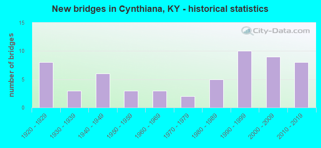
- New bridges - historical statistics
- 81920-1929
- 31930-1939
- 61940-1949
- 31950-1959
- 31960-1969
- 21970-1979
- 51980-1989
- 101990-1999
- 92000-2009
- 82010-2019

- Reconstructed bridges - Historical Statistics
- 11970-1979
- 01980-1989
- 11990-1999


- Bridge Condition - Deck
- 2.0%Excellent
- 11.8%Very good
- 47.1%Good
- 31.4%Satisfactory
- 5.9%Fair
- 2.0%Poor

- Bridge Condition - Superstructure
- 2.0%Excellent
- 13.7%Very good
- 31.4%Good
- 41.2%Satisfactory
- 7.8%Fair
- 3.9%Poor

- Bridge Condition - Substructure
- 2.0%Excellent
- 11.8%Very good
- 23.5%Good
- 37.3%Satisfactory
- 21.6%Fair
- 2.0%Poor
- 2.0%Serious

- Bridge Condition - Channel
- 1.9%Excellent
- 3.7%Very good
- 74.1%Good
- 18.5%Satisfactory
- 1.9%Poor

- Bridge Condition - Culverts
- 20.0%Very good
- 60.0%Good
- 20.0%Satisfactory
Find on map >> Show street view
Structure Number: 9B00002N, Location: ON HARRISON-BOURBON CL (Lat: 38.313056, Lng: -84.306111), Route carried "on" structure: US 27, Year Built: 1948, Year Reconstructed: 1977, Status: Posted for load, Structure Length: 4.63m (15.19ft), Average Daily Traffic: 5,044 (year 2018), Truck Traffic: 11%, Average Future Daily Traffic: 4,186 (year 2038), Design Load: H 20, Features Intersected: TOWNSEND CREEK
Minimum Vertical Clearance: 30+ m (98+ ft), Kilometerpoint: 24.835, Lanes on structure: 2, Base Highway Network: Yes, Owner: State Highway Agency, Approaching Roadway Width: 7.9m (25.9ft), Material/Design: Concrete, Design/Construction: Tee Beam, Number Of Spans In Main Unit: 4, Length of Maximum Span: 10.6m (34.8ft), Curb-To-Curb Width: 9.2m (30.2ft), Out-to-Out Width: 10.3m (33.8ft)
Condition: Deck: Satisfactory, Superstructure: Satisfactory, Substructure: Poor, Channel: Satisfactory, Operating Rating: 44.8 metric tons, Method Used To Determine Operating Rating: Load Factor (LF), Inventory Rating: 26.9 metric tons, Method Used To Determine Inventory Rating: Load Factor (LF), Structural Evaluation: Meets minimum limits, Deck Geometry: High priority of corrective action, Waterway Adequacy: Equal to present desirable criteria, Approach Roadway Alignment: Better than present minimum criteria, Bridge Posting: Required (Relationship of Operating Rating to Maximum Legal Load: 30.0 - 39.9% below), Designated Inspection Frequency: Every 24 months, Inspection Date: Febuary 2020, Deck Structure Type: Concrete Cast-file-Place, Wearing Surface/Protective System: Wearing Surface: Latex Concrete
Find on map >> Show street view
Structure Number: 49B00005N, Location: 4 MI N OF N-JCT US 62 (Lat: 38.451111, Lng: -84.284167), Route carried "on" structure: US 27, Year Built: 1935, Status: Posted for load, Structure Length: 1.31m (4.30ft), Average Daily Traffic: 4,081 (year 2019), Truck Traffic: 8%, Average Future Daily Traffic: 3,387 (year 2039), Design Load: H 15, Features Intersected: TWO LICK CREEK
Minimum Vertical Clearance: 30+ m (98+ ft), Kilometerpoint: 18.470, Lanes on structure: 2, Base Highway Network: Yes, Owner: State Highway Agency, Approaching Roadway Width: 7.3m (24.0ft), Material/Design: Concrete, Design/Construction: Tee Beam, Number Of Spans In Main Unit: 1, Length of Maximum Span: 12.2m (40.0ft), Curb or Sidewalk Widths: Left: 0.5m (1.6ft), Right: 0.5m (1.6ft), Curb-To-Curb Width: 7.3m (24.0ft), Out-to-Out Width: 8.4m (27.6ft)
Condition: Deck: Satisfactory, Superstructure: Satisfactory, Substructure: Satisfactory, Channel: Good, Operating Rating: 51.6 metric tons, Method Used To Determine Operating Rating: Load Factor (LF), Inventory Rating: 30.9 metric tons, Method Used To Determine Inventory Rating: Load Factor (LF), Structural Evaluation: Equal to present minimum criteria, Deck Geometry: High priority of replacement, Waterway Adequacy: Equal to present minimum criteria, Approach Roadway Alignment: Equal to present minimum criteria, Bridge Posting: Required (Relationship of Operating Rating to Maximum Legal Load: 20.0 - 29.9% below), Length Of Structure Improvement: 0.13m (0.43ft), Designated Inspection Frequency: Every 24 months, Inspection Date: October 2020, Bridge Improvement Cost: $147,000, Total Project Cost: $147,000, Deck Structure Type: Concrete Cast-file-Place, Wearing Surface/Protective System: Wearing Surface: Bituminous
Find on map >> Show street view
Structure Number: 49B00010N, Location: .6 MI NE OF N-JCT US 27 (Lat: 38.394722, Lng: -84.283889), Route carried "on" structure: US 62, Year Built: 1928, Status: Posted for load, Structure Length: 1.13m (3.71ft), Average Daily Traffic: 5,835 (year 2020), Truck Traffic: 7%, Average Future Daily Traffic: 5,426 (year 2040), Design Load: H 15, Features Intersected: FLAT RUN CREEK, Facility Carried by Structure: ODDVILLE AVE
Minimum Vertical Clearance: 30+ m (98+ ft), Kilometerpoint: 15.879, Lanes on structure: 2, Owner: State Highway Agency, Approaching Roadway Width: 6.7m (22.0ft), Material/Design: Concrete, Design/Construction: Tee Beam, Number Of Spans In Main Unit: 1, Length of Maximum Span: 10.4m (34.1ft), Curb or Sidewalk Widths: Left: 0.2m (0.7ft), Right: 0.2m (0.7ft), Curb-To-Curb Width: 6.6m (21.7ft), Out-to-Out Width: 7.7m (25.3ft)
Condition: Deck: Satisfactory, Superstructure: Fair, Substructure: Fair, Channel: Good, Operating Rating: 54.6 metric tons, Method Used To Determine Operating Rating: Load Factor (LF), Inventory Rating: 32.7 metric tons, Method Used To Determine Inventory Rating: Load Factor (LF), Structural Evaluation: Somewhat better than minimum adequacy, Deck Geometry: High priority of replacement, Waterway Adequacy: Equal to present desirable criteria, Approach Roadway Alignment: Equal to present minimum criteria, Bridge Posting: Required (Relationship of Operating Rating to Maximum Legal Load: 20.0 - 29.9% below), Length Of Structure Improvement: 0.11m (0.36ft), Designated Inspection Frequency: Every 24 months, Inspection Date: October 2020, Bridge Improvement Cost: $108,000, Total Project Cost: $108,000, Deck Structure Type: Concrete Cast-file-Place, Wearing Surface/Protective System: Wearing Surface: Bituminous
Find on map >> Show street view
Structure Number: 49B00011N, Location: 1.5 MI N.E. OF JCT KY 392 (Lat: 38.413889, Lng: -84.262222), Route carried "on" structure: US 62, Year Built: 1928, Status: Posted for load, Structure Length: 2.16m (7.09ft), Average Daily Traffic: 2,948 (year 2020), Truck Traffic: 5%, Average Future Daily Traffic: 2,594 (year 2040), Design Load: H 15, Features Intersected: INDIAN CREEK
Minimum Vertical Clearance: 30+ m (98+ ft), Kilometerpoint: 18.821, Lanes on structure: 2, Owner: State Highway Agency, Approaching Roadway Width: 7.3m (24.0ft), Material/Design: Concrete, Design/Construction: Tee Beam, Number Of Spans In Main Unit: 2, Length of Maximum Span: 9.8m (32.2ft), Curb or Sidewalk Widths: Left: 0.5m (1.6ft), Right: 0.5m (1.6ft), Curb-To-Curb Width: 5.9m (19.4ft), Out-to-Out Width: 6.8m (22.3ft)
Condition: Deck: Poor, Superstructure: Poor, Substructure: Fair, Channel: Satisfactory, Operating Rating: 46.3 metric tons, Method Used To Determine Operating Rating: Load Factor (LF), Inventory Rating: 27.8 metric tons, Method Used To Determine Inventory Rating: Load Factor (LF), Structural Evaluation: Meets minimum limits, Deck Geometry: High priority of replacement, Waterway Adequacy: Equal to present desirable criteria, Approach Roadway Alignment: Equal to present minimum criteria, Bridge Posting: Required (Relationship of Operating Rating to Maximum Legal Load: 30.0 - 39.9% below), Length Of Structure Improvement: 0.21m (0.69ft), Designated Inspection Frequency: Every 24 months, Inspection Date: October 2020, Bridge Improvement Cost: $197,000, Total Project Cost: $196,000, Deck Structure Type: Concrete Cast-file-Place, Wearing Surface/Protective System: Wearing Surface: Bituminous
Find on map >> Show street view
Structure Number: 49B00012N, Location: 3.0 MI N.E. OF JCT KY 392 (Lat: 38.433056, Lng: -84.251667), Route carried "on" structure: US 62, Year Built: 1928, Status: Posted for load, Structure Length: 1.34m (4.40ft), Average Daily Traffic: 2,222 (year 2018), Truck Traffic: 5%, Average Future Daily Traffic: 1,955 (year 2038), Design Load: H 15, Features Intersected: SYCAMORE CREEK
Minimum Vertical Clearance: 30+ m (98+ ft), Kilometerpoint: 21.234, Lanes on structure: 2, Owner: State Highway Agency, Approaching Roadway Width: 7.3m (24.0ft), Skew: 3 degrees, Material/Design: Concrete, Design/Construction: Tee Beam, Number Of Spans In Main Unit: 1, Length of Maximum Span: 12.2m (40.0ft), Curb or Sidewalk Widths: Left: 0.5m (1.6ft), Right: 0.5m (1.6ft), Curb-To-Curb Width: 5.8m (19.0ft), Out-to-Out Width: 6.8m (22.3ft)
Condition: Deck: Satisfactory, Superstructure: Satisfactory, Substructure: Satisfactory, Channel: Good, Operating Rating: 41.6 metric tons, Method Used To Determine Operating Rating: Load Factor (LF), Inventory Rating: 24.9 metric tons, Method Used To Determine Inventory Rating: Load Factor (LF), Structural Evaluation: Equal to present minimum criteria, Deck Geometry: High priority of replacement, Waterway Adequacy: Equal to present desirable criteria, Approach Roadway Alignment: Equal to present minimum criteria, Bridge Posting: Required (Relationship of Operating Rating to Maximum Legal Load: 30.0 - 39.9% below), Length Of Structure Improvement: 0.13m (0.43ft), Designated Inspection Frequency: Every 24 months, Inspection Date: October 2020, Bridge Improvement Cost: $119,000, Total Project Cost: $118,000, Deck Structure Type: Concrete Cast-file-Place, Wearing Surface/Protective System: Wearing Surface: Bituminous
Find on map >> Show street view
Structure Number: 49B00013N, Location: 3.5 MI N.E. OF JCT KY 392 (Lat: 38.439722, Lng: -84.248611), Route carried "on" structure: US 62, Year Built: 1928, Status: Posted for load, Structure Length: 0.91m (2.99ft), Average Daily Traffic: 2,222 (year 2018), Truck Traffic: 5%, Average Future Daily Traffic: 1,955 (year 2038), Design Load: H 15, Features Intersected: SYCAMORE CREEK
Minimum Vertical Clearance: 30+ m (98+ ft), Kilometerpoint: 22.043, Lanes on structure: 2, Owner: State Highway Agency, Approaching Roadway Width: 7.3m (24.0ft), Material/Design: Concrete, Design/Construction: Tee Beam, Number Of Spans In Main Unit: 1, Length of Maximum Span: 8.2m (26.9ft), Curb or Sidewalk Widths: Left: 0.5m (1.6ft), Right: 0.5m (1.6ft), Curb-To-Curb Width: 7.1m (23.3ft), Out-to-Out Width: 7.9m (25.9ft)
Condition: Deck: Satisfactory, Superstructure: Satisfactory, Substructure: Satisfactory, Channel: Good, Operating Rating: 50.3 metric tons, Method Used To Determine Operating Rating: Load Factor (LF), Inventory Rating: 30.1 metric tons, Method Used To Determine Inventory Rating: Load Factor (LF), Structural Evaluation: Equal to present minimum criteria, Deck Geometry: High priority of replacement, Waterway Adequacy: Better than present minimum criteria, Approach Roadway Alignment: Equal to present minimum criteria, Bridge Posting: Required (Relationship of Operating Rating to Maximum Legal Load: 30.0 - 39.9% below), Length Of Structure Improvement: 0.09m (0.30ft), Designated Inspection Frequency: Every 24 months, Inspection Date: October 2020, Bridge Improvement Cost: $99,000, Total Project Cost: $99,000, Deck Structure Type: Concrete Cast-file-Place, Wearing Surface/Protective System: Wearing Surface: Bituminous
Find on map >> Show street view
Structure Number: 49B00021N, Location: .1 MI S OF N-JCT KY 32 (Lat: 38.387500, Lng: -84.298611), Route carried "on" structure: Business US 27, Year Built: 1949, Status: Open, Structure Length: 8.08m (26.51ft), Average Daily Traffic: 11,968 (year 2020), Truck Traffic: 12%, Average Future Daily Traffic: 11,130 (year 2040), Design Load: HS 20, Features Intersected: S FK LICKING RIVER
Minimum Vertical Clearance: 30+ m (98+ ft), Kilometerpoint: 2.758, Lanes on structure: 2, Owner: State Highway Agency, Approaching Roadway Width: 11.0m (36.1ft), Material/Design: Concrete, Design/Construction: Tee Beam, Number Of Spans In Main Unit: 5, Length of Maximum Span: 15.2m (49.9ft), Curb or Sidewalk Widths: Left: 1.8m (5.9ft), Right: 1.8m (5.9ft), Curb-To-Curb Width: 8.1m (26.6ft), Out-to-Out Width: 11.6m (38.1ft)
Condition: Deck: Good, Superstructure: Satisfactory, Substructure: Fair, Channel: Good, Operating Rating: 53.4 metric tons, Method Used To Determine Operating Rating: Load Factor (LF), Inventory Rating: 32.0 metric tons, Method Used To Determine Inventory Rating: Load Factor (LF), Structural Evaluation: Somewhat better than minimum adequacy, Deck Geometry: High priority of corrective action, Waterway Adequacy: Equal to present desirable criteria, Approach Roadway Alignment: Equal to present minimum criteria, Length Of Structure Improvement: 0.81m (2.66ft), Designated Inspection Frequency: Every 24 months, Inspection Date: October 2020, Bridge Improvement Cost: $1,249,000, Total Project Cost: $1,248,000, Deck Structure Type: Concrete Cast-file-Place, Wearing Surface/Protective System: Wearing Surface: Latex Concrete
Find on map >> Show street view
Structure Number: 49B00022N, Location: .25 MI N OF S-JCT US 62 (Lat: 38.374444, Lng: -84.314444), Route carried "on" structure: Business US 27, Year Built: 1949, Status: Open, Structure Length: 0.64m (2.10ft), Average Daily Traffic: 8,631 (year 2019), Truck Traffic: 12%, Average Future Daily Traffic: 7,163 (year 2039), Design Load: H 20, Features Intersected: BR OF GRAYS RUN
Minimum Vertical Clearance: 30+ m (98+ ft), Kilometerpoint: 0.779, Lanes on structure: 2, Base Highway Network: Yes, Owner: State Highway Agency, Approaching Roadway Width: 6.7m (22.0ft), Material/Design: Concrete, Design/Construction: Culvert, Number Of Spans In Main Unit: 2, Length of Maximum Span: 3.0m (9.8ft)
Condition: Channel: Good, Culverts: Good, Operating Rating: 59.1 metric tons, Method Used To Determine Operating Rating: Load Factor (LF), Inventory Rating: 35.6 metric tons, Method Used To Determine Inventory Rating: Load Factor (LF), Structural Evaluation: Better than present minimum criteria, Waterway Adequacy: Better than present minimum criteria, Approach Roadway Alignment: Better than present minimum criteria, Designated Inspection Frequency: Every 24 months, Inspection Date: October 2020
Find on map >> Show street view
Structure Number: 49B00023N, Location: N @S-JCT KY 32 (Lat: 38.377222, Lng: -84.311944), Route carried "on" structure: Business US 27, Year Built: 1949, Status: Open, Structure Length: 0.82m (2.69ft), Average Daily Traffic: 11,228 (year 2018), Truck Traffic: 12%, Average Future Daily Traffic: 10,442 (year 2038), Design Load: H 20, Features Intersected: BR OF GRAYS RUN
Minimum Vertical Clearance: 30+ m (98+ ft), Kilometerpoint: 1.156, Lanes on structure: 2, Owner: State Highway Agency, Approaching Roadway Width: 10.4m (34.1ft), Material/Design: Concrete, Design/Construction: Culvert, Number Of Spans In Main Unit: 2, Length of Maximum Span: 3.7m (12.1ft)
Condition: Channel: Good, Culverts: Good, Operating Rating: 54.4 metric tons, Method Used To Determine Operating Rating: Field evaluation and documented engineering judgment, Inventory Rating: 39.9 metric tons, Method Used To Determine Inventory Rating: Field evaluation and documented engineering judgment, Structural Evaluation: Better than present minimum criteria, Waterway Adequacy: Better than present minimum criteria, Approach Roadway Alignment: Equal to present minimum criteria, Designated Inspection Frequency: Every 24 months, Inspection Date: October 2020
Find on map >> Show street view
Structure Number: 49B00024N, Location: 1.5 MI WEST OF JCT US 27 (Lat: 38.376944, Lng: -84.338889), Route carried "on" structure: State highway 32, Year Built: 1935, Status: Open, Structure Length: 1.71m (5.61ft), Average Daily Traffic: 599 (year 2020), Truck Traffic: 5%, Average Future Daily Traffic: 527 (year 2040), Design Load: H 15, Features Intersected: GRAYS RUN CREEK
Minimum Vertical Clearance: 30+ m (98+ ft), Kilometerpoint: 12.096, Lanes on structure: 2, Owner: State Highway Agency, Approaching Roadway Width: 5.5m (18.0ft), Material/Design: Concrete, Design/Construction: Tee Beam, Number Of Spans In Main Unit: 2, Length of Maximum Span: 7.6m (24.9ft), Curb or Sidewalk Widths: Left: 0.5m (1.6ft), Right: 0.5m (1.6ft), Curb-To-Curb Width: 6.1m (20.0ft), Out-to-Out Width: 7.1m (23.3ft)
Condition: Deck: Fair, Superstructure: Satisfactory, Substructure: Satisfactory, Channel: Satisfactory, Operating Rating: 75.0 metric tons, Method Used To Determine Operating Rating: Load Factor (LF), Inventory Rating: 45.0 metric tons, Method Used To Determine Inventory Rating: Load Factor (LF), Structural Evaluation: Equal to present minimum criteria, Deck Geometry: High priority of corrective action, Waterway Adequacy: Equal to present desirable criteria, Approach Roadway Alignment: Equal to present minimum criteria, Length Of Structure Improvement: 0.17m (0.56ft), Designated Inspection Frequency: Every 24 months, Inspection Date: October 2020, Bridge Improvement Cost: $166,000, Total Project Cost: $165,000, Deck Structure Type: Concrete Cast-file-Place, Wearing Surface/Protective System: Wearing Surface: Low Slump Concrete
Find on map >> Show street view
Structure Number: 49B00033N, Location: .4 MI W OF JCT KY 1054 (Lat: 38.442222, Lng: -84.362778), Route carried "on" structure: State highway 36, Year Built: 1928, Year Reconstructed: 1990, Status: Open, Structure Length: 2.90m (9.51ft), Average Daily Traffic: 1,101 (year 2019), Truck Traffic: 11%, Average Future Daily Traffic: 913 (year 2039), Design Load: H 15, Features Intersected: TWIN CREEK
Minimum Vertical Clearance: 30+ m (98+ ft), Kilometerpoint: 16.485, Lanes on structure: 2, Base Highway Network: Yes, Owner: State Highway Agency, Approaching Roadway Width: 6.7m (22.0ft), Skew: 4 degrees, Material/Design: Concrete, Design/Construction: Tee Beam, Number Of Spans In Main Unit: 2, Length of Maximum Span: 13.7m (44.9ft), Curb-To-Curb Width: 6.7m (22.0ft), Out-to-Out Width: 7.6m (24.9ft)
Condition: Deck: Satisfactory, Superstructure: Satisfactory, Substructure: Satisfactory, Channel: Good, Operating Rating: 53.6 metric tons, Method Used To Determine Operating Rating: Load Factor (LF), Inventory Rating: 32.1 metric tons, Method Used To Determine Inventory Rating: Load Factor (LF), Structural Evaluation: Equal to present minimum criteria, Deck Geometry: High priority of corrective action, Waterway Adequacy: Better than present minimum criteria, Approach Roadway Alignment: Equal to present minimum criteria, Designated Inspection Frequency: Every 24 months, Inspection Date: October 2020, Deck Structure Type: Concrete Cast-file-Place, Wearing Surface/Protective System: Wearing Surface: Monolithic Concrete, Deck Protection: Epoxy Coated Reinforcing
Find on map >> Show street view
Structure Number: 49B00037N, Location: S @JCT RELOCATED KY 982 (Lat: 38.341944, Lng: -84.307778), Route carried "on" structure: US 27, Year Built: 1949, Status: Open, Structure Length: 1.22m (4.00ft), Average Daily Traffic: 5,044 (year 2018), Truck Traffic: 11%, Average Future Daily Traffic: 4,186 (year 2038), Design Load: H 20, Features Intersected: EDGEWATER BRANCH
Minimum Vertical Clearance: 30+ m (98+ ft), Kilometerpoint: 3.405, Lanes on structure: 2, Base Highway Network: Yes, Owner: State Highway Agency, Approaching Roadway Width: 7.3m (24.0ft), Material/Design: Concrete, Design/Construction: Culvert, Number Of Spans In Main Unit: 3, Length of Maximum Span: 3.7m (12.1ft)
Condition: Channel: Satisfactory, Culverts: Satisfactory, Operating Rating: 56.8 metric tons, Method Used To Determine Operating Rating: Load Factor (LF), Inventory Rating: 34.3 metric tons, Method Used To Determine Inventory Rating: Load Factor (LF), Structural Evaluation: Equal to present minimum criteria, Waterway Adequacy: Better than present minimum criteria, Approach Roadway Alignment: Better than present minimum criteria, Designated Inspection Frequency: Every 24 months, Inspection Date: October 2020
Find on map >> Show street view
Structure Number: 49B00045N, Location: 2.5 MI EAST OF JCT US 62 (Lat: 38.401944, Lng: -84.235556), Route carried "on" structure: State highway 392, Year Built: 1956, Status: Posted for load, Structure Length: 0.85m (2.79ft), Average Daily Traffic: 1,256 (year 2018), Average Future Daily Traffic: 1,105 (year 2038), Design Load: H 15, Features Intersected: SO.BR. INDIAN CREEK
Minimum Vertical Clearance: 30+ m (98+ ft), Kilometerpoint: 4.062, Lanes on structure: 2, Owner: State Highway Agency, Approaching Roadway Width: 5.8m (19.0ft), Material/Design: Concrete, Design/Construction: Tee Beam, Number Of Spans In Main Unit: 1, Length of Maximum Span: 7.6m (24.9ft), Curb or Sidewalk Widths: Left: 0.6m (2.0ft), Right: 0.6m (2.0ft), Curb-To-Curb Width: 6.8m (22.3ft), Out-to-Out Width: 8.0m (26.2ft)
Condition: Deck: Satisfactory, Superstructure: Satisfactory, Substructure: Satisfactory, Channel: Satisfactory, Operating Rating: 47.7 metric tons, Method Used To Determine Operating Rating: Load Factor (LF), Inventory Rating: 28.7 metric tons, Method Used To Determine Inventory Rating: Load Factor (LF), Structural Evaluation: Equal to present minimum criteria, Deck Geometry: High priority of corrective action, Waterway Adequacy: Equal to present minimum criteria, Approach Roadway Alignment: Equal to present minimum criteria, Bridge Posting: Required (Relationship of Operating Rating to Maximum Legal Load: > 39.9% below), Designated Inspection Frequency: Every 24 months, Inspection Date: October 2020, Deck Structure Type: Concrete Cast-file-Place, Wearing Surface/Protective System: Wearing Surface: Bituminous
Find on map >> Show street view
Structure Number: 49B00046N, Location: 3.1 MI EAST OF JCT US 62 (Lat: 38.403611, Lng: -84.225278), Route carried "on" structure: State highway 392, Year Built: 1956, Status: Posted for load, Structure Length: 1.04m (3.41ft), Average Daily Traffic: 785 (year 2019), Average Future Daily Traffic: 690 (year 2039), Design Load: H 15, Features Intersected: INDIAN CREEK
Minimum Vertical Clearance: 30+ m (98+ ft), Kilometerpoint: 4.965, Lanes on structure: 2, Owner: State Highway Agency, Approaching Roadway Width: 5.8m (19.0ft), Material/Design: Concrete, Design/Construction: Tee Beam, Number Of Spans In Main Unit: 1, Length of Maximum Span: 9.1m (29.9ft), Curb or Sidewalk Widths: Left: 0.6m (2.0ft), Right: 0.6m (2.0ft), Curb-To-Curb Width: 6.8m (22.3ft), Out-to-Out Width: 7.9m (25.9ft)
Condition: Deck: Good, Superstructure: Good, Substructure: Satisfactory, Channel: Good, Operating Rating: 40.7 metric tons, Method Used To Determine Operating Rating: Load Factor (LF), Inventory Rating: 24.4 metric tons, Method Used To Determine Inventory Rating: Load Factor (LF), Structural Evaluation: Equal to present minimum criteria, Deck Geometry: Meets minimum limits, Waterway Adequacy: Equal to present desirable criteria, Approach Roadway Alignment: Equal to present minimum criteria, Bridge Posting: Required (Relationship of Operating Rating to Maximum Legal Load: > 39.9% below), Designated Inspection Frequency: Every 24 months, Inspection Date: October 2020, Deck Structure Type: Concrete Cast-file-Place, Wearing Surface/Protective System: Wearing Surface: Bituminous
Find on map >> Show street view
Structure Number: 49B00053N, Location: .05 MI EAST OF JCT KY 356 (Lat: 38.390556, Lng: -84.303056), Route carried "on" structure: State highway 36, Year Built: 1938, Status: Open, Structure Length: 7.38m (24.21ft), Average Daily Traffic: 3,482 (year 2019), Truck Traffic: 11%, Average Future Daily Traffic: 3,238 (year 2039), Design Load: H 20, Features Intersected: SO.FK. LICKING RIVER, Facility Carried by Structure: PLEASANT STREET
Minimum Vertical Clearance: 30+ m (98+ ft), Kilometerpoint: 24.668, Lanes on structure: 2, Owner: State Highway Agency, Approaching Roadway Width: 7.3m (24.0ft), Material/Design: Steel, Design/Construction: Stringer/Multi-beam, Number Of Spans In Main Unit: 4, Length of Maximum Span: 18.3m (60.0ft), Curb or Sidewalk Widths: Left: 2.1m (6.9ft), Right: 2.1m (6.9ft), Curb-To-Curb Width: 7.3m (24.0ft), Out-to-Out Width: 11.6m (38.1ft)
Condition: Deck: Satisfactory, Superstructure: Satisfactory, Substructure: Fair, Channel: Good, Operating Rating: 58.1 metric tons, Method Used To Determine Operating Rating: Allowable Stress (AS), Inventory Rating: 37.2 metric tons, Method Used To Determine Inventory Rating: Allowable Stress (AS), Structural Evaluation: Somewhat better than minimum adequacy, Deck Geometry: High priority of replacement, Waterway Adequacy: Equal to present desirable criteria, Approach Roadway Alignment: Equal to present minimum criteria, Length Of Structure Improvement: 0.74m (2.43ft), Designated Inspection Frequency: Every 24 months, Underwater Inspection Frequency: Every 60 months, Inspection Date: October 2020, Underwater Inspection Date: November 2021, Bridge Improvement Cost: $1,165,000, Total Project Cost: $1,164,000, Deck Structure Type: Concrete Cast-file-Place, Wearing Surface/Protective System: Wearing Surface: Low Slump Concrete
Find on map >> Show street view
Structure Number: 49B00057N, Location: 2.1 MI E OF JCT KY 1842 (Lat: 38.376111, Lng: -84.378611), Route carried "on" structure: State highway 32, Year Built: 1982, Status: Open, Structure Length: 3.51m (11.52ft), Average Daily Traffic: 599 (year 2020), Truck Traffic: 5%, Average Future Daily Traffic: 527 (year 2040), Design Load: HS 20, Features Intersected: MILL CREEK
Minimum Vertical Clearance: 30+ m (98+ ft), Kilometerpoint: 8.275, Lanes on structure: 2, Owner: State Highway Agency, Approaching Roadway Width: 5.5m (18.0ft), Material/Design: Prestressed concrete, Design/Construction: Stringer/Multi-beam, Number Of Spans In Main Unit: 3, Length of Maximum Span: 15.2m (49.9ft), Curb-To-Curb Width: 8.5m (27.9ft), Out-to-Out Width: 9.5m (31.2ft)
Condition: Deck: Good, Superstructure: Good, Substructure: Satisfactory, Channel: Good, Operating Rating: 74.1 metric tons, Method Used To Determine Operating Rating: Load Factor (LF), Inventory Rating: 44.5 metric tons, Method Used To Determine Inventory Rating: Load Factor (LF), Structural Evaluation: Equal to present minimum criteria, Deck Geometry: Somewhat better than minimum adequacy, Waterway Adequacy: Better than present minimum criteria, Approach Roadway Alignment: Equal to present minimum criteria, Designated Inspection Frequency: Every 24 months, Inspection Date: October 2020, Deck Structure Type: Concrete Cast-file-Place, Wearing Surface/Protective System: Wearing Surface: Monolithic Concrete, Deck Protection: Epoxy Coated Reinforcing
Find on map >> Show street view
Structure Number: 49B00058N, Location: 1.4 MI. S.-JCT. KY 32 (Lat: 38.368333, Lng: -84.294722), Route carried "on" structure: State highway 982, Year Built: 1983, Status: Open, Structure Length: 9.30m (30.51ft), Average Daily Traffic: 3,551 (year 2020), Truck Traffic: 7%, Average Future Daily Traffic: 3,089 (year 2040), Design Load: HS 20, Features Intersected: LICKING RIVER
Minimum Vertical Clearance: 30+ m (98+ ft), Kilometerpoint: 7.100, Lanes on structure: 2, Owner: State Highway Agency, Approaching Roadway Width: 5.8m (19.0ft), Skew: 2 degrees, Material/Design: Prestressed concrete, Design/Construction: Stringer/Multi-beam, Number Of Spans In Main Unit: 4, Length of Maximum Span: 28.7m (94.2ft), Curb-To-Curb Width: 8.5m (27.9ft), Out-to-Out Width: 9.5m (31.2ft)
Condition: Deck: Satisfactory, Superstructure: Good, Substructure: Good, Channel: Good, Operating Rating: 62.2 metric tons, Method Used To Determine Operating Rating: Load Factor (LF), Inventory Rating: 37.4 metric tons, Method Used To Determine Inventory Rating: Load Factor (LF), Structural Evaluation: Better than present minimum criteria, Deck Geometry: Meets minimum limits, Waterway Adequacy: Equal to present desirable criteria, Approach Roadway Alignment: Better than present minimum criteria, Designated Inspection Frequency: Every 24 months, Inspection Date: October 2020, Deck Structure Type: Concrete Cast-file-Place, Wearing Surface/Protective System: Wearing Surface: Monolithic Concrete, Deck Protection: Epoxy Coated Reinforcing
Find on map >> Show street view
Structure Number: 49B00065N, Location: 2.6 MI. FRM N.CL CYNTHANA (Lat: 38.432778, Lng: -84.284722), Route carried "on" structure: US 27, Year Built: 1986, Status: Open, Structure Length: 3.78m (12.40ft), Average Daily Traffic: 4,081 (year 2019), Truck Traffic: 8%, Average Future Daily Traffic: 3,387 (year 2039), Design Load: HS 20, Features Intersected: SYCAMORE CREEK
Minimum Vertical Clearance: 30+ m (98+ ft), Kilometerpoint: 16.388, Lanes on structure: 2, Base Highway Network: Yes, Owner: State Highway Agency, Approaching Roadway Width: 12.2m (40.0ft), Material/Design: Prestressed concrete, Design/Construction: Stringer/Multi-beam, Number Of Spans In Main Unit: 3, Length of Maximum Span: 18.3m (60.0ft), Curb or Sidewalk Widths: Left: 0.5m (1.6ft), Right: 0.5m (1.6ft), Curb-To-Curb Width: 11.6m (38.1ft), Out-to-Out Width: 12.6m (41.3ft)
Condition: Deck: Good, Superstructure: Very good, Substructure: Satisfactory, Channel: Good, Operating Rating: 89.4 metric tons, Method Used To Determine Operating Rating: Load Factor (LF), Inventory Rating: 53.6 metric tons, Method Used To Determine Inventory Rating: Load Factor (LF), Structural Evaluation: Equal to present minimum criteria, Deck Geometry: Somewhat better than minimum adequacy, Waterway Adequacy: Better than present minimum criteria, Approach Roadway Alignment: Better than present minimum criteria, Designated Inspection Frequency: Every 24 months, Inspection Date: October 2020, Deck Structure Type: Concrete Cast-file-Place, Wearing Surface/Protective System: Wearing Surface: Monolithic Concrete, Deck Protection: Epoxy Coated Reinforcing
Find on map >> Show street view
Structure Number: 49B00067N, Location: .05 MI N.W. -US 27 (Lat: 38.383889, Lng: -84.305000), Route carried "on" structure: State highway 3016, Year Built: 1992, Status: Open, Structure Length: 1.68m (5.51ft), Average Daily Traffic: 2,598 (year 2018), Average Future Daily Traffic: 2,416 (year 2038), Design Load: HS 25 or greater, Features Intersected: GRAY'S RUN CREEK, Facility Carried by Structure: OLD LEESBURG ROAD
Minimum Vertical Clearance: 30+ m (98+ ft), Kilometerpoint: 1.962, Lanes on structure: 2, Owner: State Highway Agency, Approaching Roadway Width: 7.3m (24.0ft), Skew: 1 degrees, Material/Design: Prestressed concrete, Design/Construction: Box Beam or Girders - Single/Spread, Number Of Spans In Main Unit: 1, Length of Maximum Span: 16.2m (53.1ft), Curb-To-Curb Width: 9.1m (29.9ft), Out-to-Out Width: 10.1m (33.1ft)
Condition: Deck: Good, Superstructure: Good, Substructure: Good, Channel: Good, Operating Rating: 83.3 metric tons, Method Used To Determine Operating Rating: Load Factor (LF), Inventory Rating: 50.0 metric tons, Method Used To Determine Inventory Rating: Load Factor (LF), Structural Evaluation: Better than present minimum criteria, Deck Geometry: Meets minimum limits, Waterway Adequacy: Better than present minimum criteria, Approach Roadway Alignment: Equal to present minimum criteria, Designated Inspection Frequency: Every 24 months, Inspection Date: October 2020, Deck Structure Type: Concrete Cast-file-Place, Wearing Surface/Protective System: Wearing Surface: Monolithic Concrete, Deck Protection: Epoxy Coated Reinforcing
Find on map >> Show street view
Structure Number: 49B00068N, Location: 1.1 MI NE JCT US 62 (Lat: 38.406111, Lng: -84.290000), Route carried "on" structure: US 27, Year Built: 1995, Status: Open, Structure Length: 9.45m (31.00ft), Average Daily Traffic: 4,326 (year 2019), Truck Traffic: 8%, Average Future Daily Traffic: 3,590 (year 2039), Design Load: HS 25 or greater, Features Intersected: INDIAN CREEK
Minimum Vertical Clearance: 30+ m (98+ ft), Kilometerpoint: 13.161, Lanes on structure: 2, Base Highway Network: Yes, Owner: State Highway Agency, Approaching Roadway Width: 15.8m (51.8ft), Skew: 4 degrees, Material/Design: Prestressed concrete continuous, Design/Construction: Stringer/Multi-beam, Number Of Spans In Main Unit: 3, Length of Maximum Span: 33.5m (109.9ft), Curb or Sidewalk Widths: Left: 0.5m (1.6ft), Right: 0.5m (1.6ft), Curb-To-Curb Width: 15.8m (51.8ft), Out-to-Out Width: 16.8m (55.1ft)
Condition: Deck: Good, Superstructure: Very good, Substructure: Satisfactory, Channel: Good, Operating Rating: 99.8 metric tons, Method Used To Determine Operating Rating: Load Factor (LF), Inventory Rating: 60.7 metric tons, Method Used To Determine Inventory Rating: Load Factor (LF), Structural Evaluation: Equal to present minimum criteria, Deck Geometry: Superior to present desirable criteria, Waterway Adequacy: Better than present minimum criteria, Approach Roadway Alignment: Better than present minimum criteria, Designated Inspection Frequency: Every 24 months, Inspection Date: October 2020, Deck Structure Type: Concrete Cast-file-Place, Wearing Surface/Protective System: Wearing Surface: Monolithic Concrete, Deck Protection: Epoxy Coated Reinforcing
Find on map >> Show street view
Structure Number: 49B00072N, Location: .5 MI N of JCT US-62 (Lat: 38.396389, Lng: -84.295278), Route carried "on" structure: Business US 27, Year Built: 2009, Status: Open, Structure Length: 27.10m (88.91ft), Average Daily Traffic: 3,041 (year 2018), Truck Traffic: 8%, Average Future Daily Traffic: 2,828 (year 2038), Design Load: HS 25 or greater, Features Intersected: CSX RAILROAD
Minimum Vertical Clearance: 30+ m (98+ ft), Kilometerpoint: 3.796, Lanes on structure: 2, Owner: State Highway Agency, Approaching Roadway Width: 10.2m (33.5ft), Material/Design: Prestressed concrete, Design/Construction: Stringer/Multi-beam, Number Of Spans In Main Unit: 9, Length of Maximum Span: 30.4m (99.7ft), Curb or Sidewalk Widths: Left: 0.5m (1.6ft), Right: 1.7m (5.6ft), Curb-To-Curb Width: 9.8m (32.2ft), Out-to-Out Width: 12.4m (40.7ft)
Condition: Deck: Very good, Superstructure: Good, Substructure: Very good, Operating Rating: 99.8 metric tons, Method Used To Determine Operating Rating: Load Factor (LF), Inventory Rating: 61.6 metric tons, Method Used To Determine Inventory Rating: Load Factor (LF), Structural Evaluation: Better than present minimum criteria, Deck Geometry: Meets minimum limits, Underclear: Superior to present desirable criteria, Approach Roadway Alignment: Equal to present desirable criteria, Designated Inspection Frequency: Every 24 months, Inspection Date: October 2020, Deck Structure Type: Concrete Cast-file-Place, Wearing Surface/Protective System: Wearing Surface: Monolithic Concrete, Deck Protection: Epoxy Coated Reinforcing
Find on map >> Show street view
Structure Number: 49B00073N, Location: 2.5 MI WEST OF JCT KY-36 (Lat: 38.398889, Lng: -84.347778), Route carried "on" structure: State highway 356, Year Built: 2010, Status: Open, Structure Length: 4.99m (16.37ft), Average Daily Traffic: 1,135 (year 2018), Average Future Daily Traffic: 998 (year 2038), Design Load: Greater than HL93, Features Intersected: MILL CREEK
Minimum Vertical Clearance: 30+ m (98+ ft), Kilometerpoint: 19.396, Lanes on structure: 2, Owner: State Highway Agency, Approaching Roadway Width: 9.7m (31.8ft), Skew: 3 degrees, Material/Design: Prestressed concrete continuous, Design/Construction: Stringer/Multi-beam, Number Of Spans In Main Unit: 3, Length of Maximum Span: 20.4m (66.9ft), Curb-To-Curb Width: 9.8m (32.2ft), Out-to-Out Width: 10.7m (35.1ft)
Condition: Deck: Very good, Superstructure: Very good, Substructure: Very good, Channel: Very good, Operating Rating: 59.3 metric tons, Method Used To Determine Operating Rating: Load and Resistance Factor Rating (LRFR) rating reported by rating factor(RF) method using HL-93 loadings, Inventory Rating: 45.7 metric tons, Method Used To Determine Inventory Rating: Load and Resistance Factor Rating (LRFR) rating reported by rating factor(RF) method using HL-93 loadings, Structural Evaluation: Equal to present desirable criteria, Deck Geometry: Somewhat better than minimum adequacy, Waterway Adequacy: Equal to present desirable criteria, Approach Roadway Alignment: Better than present minimum criteria, Designated Inspection Frequency: Every 24 months, Inspection Date: October 2020, Deck Structure Type: Concrete Cast-file-Place, Wearing Surface/Protective System: Wearing Surface: Monolithic Concrete, Deck Protection: Epoxy Coated Reinforcing
Find on map >> Show street view
Structure Number: 49B00074N, Location: .1MI W of JCT US 27 (Lat: 38.399722, Lng: -84.296944), Route carried "on" structure: US 27, Year Built: 2011, Status: Open, Structure Length: 27.58m (90.49ft), Average Daily Traffic: 2,881 (year 2020), Truck Traffic: 13%, Average Future Daily Traffic: 2,391 (year 2040), Design Load: HS 25 or greater, Features Intersected: S FORK LICKING RIV & CSX, Facility Carried by Structure: KY 62
Minimum Vertical Clearance: 30+ m (98+ ft), Kilometerpoint: 12.009, Lanes on structure: 2, Base Highway Network: Yes, Owner: State Highway Agency, Approaching Roadway Width: 13.5m (44.3ft), Skew: 12 degrees, Material/Design: Steel continuous, Design/Construction: Stringer/Multi-beam, Number Of Spans In Main Unit: 5, Length of Maximum Span: 79.6m (261.2ft), Curb or Sidewalk Widths: Left: 0.5m (1.6ft), Right: 0.5m (1.6ft), Curb-To-Curb Width: 13.4m (44.0ft), Out-to-Out Width: 13.4m (44.0ft)
Condition: Deck: Very good, Superstructure: Very good, Substructure: Good, Channel: Good, Operating Rating: 64.0 metric tons, Method Used To Determine Operating Rating: Load Factor (LF), Inventory Rating: 38.5 metric tons, Method Used To Determine Inventory Rating: Load Factor (LF), Structural Evaluation: Better than present minimum criteria, Deck Geometry: Better than present minimum criteria, Underclear: High priority of corrective action, Waterway Adequacy: Equal to present desirable criteria, Approach Roadway Alignment: Equal to present minimum criteria, Designated Inspection Frequency: Every 24 months, Inspection Date: October 2020, Deck Structure Type: Concrete Cast-file-Place, Wearing Surface/Protective System: Wearing Surface: Monolithic Concrete, Deck Protection: Epoxy Coated Reinforcing
Find on map >> Show street view
Structure Number: 49B00075N, Location: .9 MILES WEST OF US-27 (Lat: 38.399167, Lng: -84.310556), Route carried "on" structure: US 27, Year Built: 2011, Status: Open, Structure Length: 6.86m (22.51ft), Average Daily Traffic: 3,215 (year 2019), Truck Traffic: 13%, Average Future Daily Traffic: 2,668 (year 2039), Design Load: HS 25 or greater, Features Intersected: KY-36, Facility Carried by Structure: US-62
Minimum Vertical Clearance: 30+ m (98+ ft), Kilometerpoint: 10.815, Lanes on structure: 2, Lanes under structure: 2, Base Highway Network: Yes, Owner: State Highway Agency, Approaching Roadway Width: 14.6m (47.9ft), Skew: 2 degrees, Material/Design: Prestressed concrete continuous, Design/Construction: Stringer/Multi-beam, Number Of Spans In Main Unit: 3, Length of Maximum Span: 31.9m (104.7ft), Curb or Sidewalk Widths: Left: 0.5m (1.6ft), Right: 0.5m (1.6ft), Curb-To-Curb Width: 14.4m (47.2ft), Out-to-Out Width: 15.3m (50.2ft)
Condition: Deck: Very good, Superstructure: Very good, Substructure: Very good, Operating Rating: 72.1 metric tons, Method Used To Determine Operating Rating: Load Factor (LF), Inventory Rating: 43.3 metric tons, Method Used To Determine Inventory Rating: Load Factor (LF), Structural Evaluation: Equal to present desirable criteria, Deck Geometry: Superior to present desirable criteria, Underclear: Superior to present desirable criteria, Approach Roadway Alignment: Better than present minimum criteria, Designated Inspection Frequency: Every 24 months, Inspection Date: October 2020, Deck Structure Type: Concrete Cast-file-Place, Wearing Surface/Protective System: Wearing Surface: Monolithic Concrete, Deck Protection: Epoxy Coated Reinforcing
Find on map >> Show street view
Structure Number: 49B00076N, Location: 2.2 MILES WEST OF US-27 (Lat: 38.384444, Lng: -84.324444), Route carried "on" structure: US 27, Year Built: 2011, Status: Open, Structure Length: 9.94m (32.61ft), Average Daily Traffic: 4,383 (year 2019), Truck Traffic: 13%, Average Future Daily Traffic: 3,637 (year 2039), Design Load: HS 25 or greater, Features Intersected: GRAYS RUN CREEK, Facility Carried by Structure: US-62
Minimum Vertical Clearance: 30+ m (98+ ft), Kilometerpoint: 8.608, Lanes on structure: 2, Base Highway Network: Yes, Owner: State Highway Agency, Approaching Roadway Width: 14.4m (47.2ft), Material/Design: Prestressed concrete continuous, Design/Construction: Stringer/Multi-beam, Number Of Spans In Main Unit: 3, Length of Maximum Span: 36.6m (120.1ft), Curb-To-Curb Width: 13.5m (44.3ft), Out-to-Out Width: 14.4m (47.2ft)
Condition: Deck: Very good, Superstructure: Good, Substructure: Very good, Channel: Good, Operating Rating: 85.2 metric tons, Method Used To Determine Operating Rating: Load Factor (LF), Inventory Rating: 51.2 metric tons, Method Used To Determine Inventory Rating: Load Factor (LF), Structural Evaluation: Better than present minimum criteria, Deck Geometry: Superior to present desirable criteria, Waterway Adequacy: Equal to present desirable criteria, Approach Roadway Alignment: Better than present minimum criteria, Designated Inspection Frequency: Every 24 months, Inspection Date: October 2020, Deck Structure Type: Concrete Cast-file-Place, Wearing Surface/Protective System: Wearing Surface: Monolithic Concrete, Deck Protection: Epoxy Coated Reinforcing
Find on map >> Show street view
Structure Number: 49B00077N, Location: 0.3 MI S E OF U.S. 27 (Lat: 38.378611, Lng: -84.303889), Route carried "on" structure: State highway 3016, Year Built: 1968, Status: Open, Structure Length: 9.33m (30.61ft), Average Daily Traffic: 4,359 (year 2019), Average Future Daily Traffic: 4,053 (year 2039), Design Load: H 20, Features Intersected: S FORK OF LICKING RIVER
Minimum Vertical Clearance: 30+ m (98+ ft), Kilometerpoint: 1.387, Lanes on structure: 2, Owner: State Highway Agency, Approaching Roadway Width: 7.3m (24.0ft), Material/Design: Steel continuous, Design/Construction: Stringer/Multi-beam, Number Of Spans In Main Unit: 3, Length of Maximum Span: 36.6m (120.1ft), Curb or Sidewalk Widths: Left: 0.5m (1.6ft), Right: 0.5m (1.6ft), Curb-To-Curb Width: 8.7m (28.5ft), Out-to-Out Width: 9.7m (31.8ft)
Condition: Deck: Satisfactory, Superstructure: Satisfactory, Substructure: Good, Channel: Good, Operating Rating: 60.2 metric tons, Method Used To Determine Operating Rating: Load Factor (LF), Inventory Rating: 36.1 metric tons, Method Used To Determine Inventory Rating: Load Factor (LF), Structural Evaluation: Equal to present minimum criteria, Deck Geometry: Meets minimum limits, Waterway Adequacy: Equal to present desirable criteria, Approach Roadway Alignment: Equal to present minimum criteria, Designated Inspection Frequency: Every 24 months, Inspection Date: October 2020, Deck Structure Type: Concrete Cast-file-Place, Wearing Surface/Protective System: Wearing Surface: Monolithic Concrete
Find on map >> Show street view
Structure Number: 49B00078N, Location: .6 Mi. W of JCT w/ Ky1743 (Lat: 38.420000, Lng: -84.334722), Route carried "on" structure: State highway 36, Year Built: 2016, Status: Open, Structure Length: 3.54m (11.61ft), Average Daily Traffic: 2,720 (year 2020), Truck Traffic: 11%, Average Future Daily Traffic: 2,257 (year 2040), Design Load: Greater than HL93, Features Intersected: Mill Creek
Minimum Vertical Clearance: 30+ m (98+ ft), Kilometerpoint: 20.271, Lanes on structure: 2, Base Highway Network: Yes, Owner: State Highway Agency, Approaching Roadway Width: 11.0m (36.1ft), Skew: 1 degrees, Material/Design: Prestressed concrete, Design/Construction: Stringer/Multi-beam, Number Of Spans In Main Unit: 1, Length of Maximum Span: 34.4m (112.9ft), Curb-To-Curb Width: 11.2m (36.7ft), Out-to-Out Width: 12.0m (39.4ft)
Condition: Deck: Excellent, Superstructure: Excellent, Substructure: Excellent, Channel: Excellent, Operating Rating: 97.2 metric tons, Method Used To Determine Operating Rating: Load and Resistance Factor Rating (LRFR) rating reported by rating factor(RF) method using HL-93 loadings, Inventory Rating: 75.2 metric tons, Method Used To Determine Inventory Rating: Load and Resistance Factor Rating (LRFR) rating reported by rating factor(RF) method using HL-93 loadings, Structural Evaluation: Superior to present desirable criteria, Deck Geometry: Somewhat better than minimum adequacy, Waterway Adequacy: Better than present minimum criteria, Approach Roadway Alignment: Better than present minimum criteria, Designated Inspection Frequency: Every 24 months, Inspection Date: October 2020, Deck Structure Type: Concrete Cast-file-Place, Wearing Surface/Protective System: Wearing Surface: Monolithic Concrete, Deck Protection: Epoxy Coated Reinforcing
Find on map >> Show street view
Structure Number: 49C00022N, Location: 1.4 MI-VIA CR1001-W-US27 (Lat: 38.438611, Lng: -84.301667), Route carried "on" structure: County highway 1001, Year Built: 1975, Status: Posted for load, Structure Length: 12.20m (40.03ft), Average Daily Traffic: 393 (year 2006), Average Future Daily Traffic: 2,026 (year 2026), Design Load: HS 20, Features Intersected: SO.FK. LICKING RIVER, Facility Carried by Structure: POINDEXTER
Minimum Vertical Clearance: 30+ m (98+ ft), Kilometerpoint: 5.303, Lanes on structure: 2, Owner: County Highway Agency, Approaching Roadway Width: 6.1m (20.0ft), Material/Design: Prestressed concrete, Design/Construction: Box Beam or Girders - Multiple, Number Of Spans In Main Unit: 4, Length of Maximum Span: 30.5m (100.1ft), Curb or Sidewalk Widths: Left: 0.2m (0.7ft), Right: 0.2m (0.7ft), Curb-To-Curb Width: 6.1m (20.0ft), Out-to-Out Width: 6.6m (21.7ft)
Condition: Deck: Satisfactory, Superstructure: Satisfactory, Substructure: Satisfactory, Channel: Good, Operating Rating: 18.4 metric tons, Method Used To Determine Operating Rating: Load Factor (LF), Inventory Rating: 11.1 metric tons, Method Used To Determine Inventory Rating: Load Factor (LF), Structural Evaluation: Meets minimum limits, Deck Geometry: Meets minimum limits, Waterway Adequacy: Equal to present desirable criteria, Approach Roadway Alignment: Somewhat better than minimum adequacy, Bridge Posting: Required (Relationship of Operating Rating to Maximum Legal Load: > 39.9% below), Designated Inspection Frequency: Every 24 months, Inspection Date: April 2020, Deck Structure Type: Concrete Cast-file-Place, Wearing Surface/Protective System: Wearing Surface: Monolithic Concrete
Find on map >> Show street view
Structure Number: 49C00023N, Location: .01 MI N OF JCT CR 1001 (Lat: 38.444444, Lng: -84.298611), Route carried "on" structure: County highway 1062, Year Built: 1968, Status: Posted for load, Structure Length: 1.01m (3.31ft), Average Daily Traffic: 98 (year 2006), Average Future Daily Traffic: 2,026 (year 2026), Design Load: H 20, Features Intersected: TWOLICK CREEK, Facility Carried by Structure: ROBINSON UNION
Minimum Vertical Clearance: 30+ m (98+ ft), Kilometerpoint: 0.048, Lanes on structure: 1, Owner: County Highway Agency, Approaching Roadway Width: 3.7m (12.1ft), Material/Design: Prestressed concrete, Design/Construction: Box Beam or Girders - Multiple, Number Of Spans In Main Unit: 1, Length of Maximum Span: 9.1m (29.9ft), Curb-To-Curb Width: 4.7m (15.4ft), Out-to-Out Width: 4.7m (15.4ft)
Condition: Deck: Good, Superstructure: Satisfactory, Substructure: Fair, Channel: Good, Operating Rating: 51.6 metric tons, Method Used To Determine Operating Rating: Load Factor (LF), Inventory Rating: 30.9 metric tons, Method Used To Determine Inventory Rating: Load Factor (LF), Structural Evaluation: Somewhat better than minimum adequacy, Deck Geometry: Better than present minimum criteria, Waterway Adequacy: Equal to present desirable criteria, Approach Roadway Alignment: Equal to present minimum criteria, Bridge Posting: Required (Relationship of Operating Rating to Maximum Legal Load: 10.0 - 19.9% below), Designated Inspection Frequency: Every 24 months, Inspection Date: April 2020, Deck Structure Type: Concrete Precast Panels, Wearing Surface/Protective System: Wearing Surface: Bituminous
Find on map >> Show street view
Structure Number: 49C00033N, Location: .3 MI E OF JCT CR 5124 (Lat: 38.346667, Lng: -84.269444), Route carried "on" structure: County highway 1122, Year Built: 1925, Status: Open, Structure Length: 0.73m (2.40ft), Average Daily Traffic: 524 (year 2006), Average Future Daily Traffic: 2,026 (year 2026), Design Load: H 20, Features Intersected: PADDY'S RUN, Facility Carried by Structure: COOK RD
Minimum Vertical Clearance: 30+ m (98+ ft), Kilometerpoint: 0.486, Lanes on structure: 2, Owner: County Highway Agency, Approaching Roadway Width: 4.9m (16.1ft), Material/Design: Prestressed concrete, Design/Construction: Box Beam or Girders - Multiple, Number Of Spans In Main Unit: 1, Length of Maximum Span: 7.0m (23.0ft), Curb-To-Curb Width: 5.4m (17.7ft), Out-to-Out Width: 5.5m (18.0ft)
Condition: Deck: Good, Superstructure: Satisfactory, Substructure: Fair, Channel: Good, Operating Rating: 65.5 metric tons, Method Used To Determine Operating Rating: Load Factor (LF), Inventory Rating: 39.3 metric tons, Method Used To Determine Inventory Rating: Load Factor (LF), Structural Evaluation: Somewhat better than minimum adequacy, Deck Geometry: High priority of replacement, Waterway Adequacy: Somewhat better than minimum adequacy, Approach Roadway Alignment: Equal to present minimum criteria, Length Of Structure Improvement: 0.07m (0.23ft), Designated Inspection Frequency: Every 24 months, Inspection Date: March 2020, Bridge Improvement Cost: $54,000, Total Project Cost: $54,000, Deck Structure Type: Concrete Precast Panels, Wearing Surface/Protective System: Wearing Surface: Bituminous
Find on map >> Show street view
Structure Number: 49C00034N, Location: .1 MI E OF JCT CR 5124 (Lat: 38.347500, Lng: -84.273333), Route carried "on" structure: County highway 1122, Year Built: 1925, Status: Open, Structure Length: 0.73m (2.40ft), Average Daily Traffic: 524 (year 2006), Average Future Daily Traffic: 2,026 (year 2026), Design Load: H 20, Features Intersected: PADDY'S RUN, Facility Carried by Structure: COOK RD
Minimum Vertical Clearance: 30+ m (98+ ft), Kilometerpoint: 0.097, Lanes on structure: 2, Owner: County Highway Agency, Approaching Roadway Width: 4.9m (16.1ft), Material/Design: Prestressed concrete, Design/Construction: Box Beam or Girders - Multiple, Number Of Spans In Main Unit: 1, Length of Maximum Span: 6.7m (22.0ft), Curb-To-Curb Width: 5.3m (17.4ft), Out-to-Out Width: 5.5m (18.0ft)
Condition: Deck: Satisfactory, Superstructure: Satisfactory, Substructure: Fair, Channel: Good, Operating Rating: 66.9 metric tons, Method Used To Determine Operating Rating: Load Factor (LF), Inventory Rating: 40.1 metric tons, Method Used To Determine Inventory Rating: Load Factor (LF), Structural Evaluation: Somewhat better than minimum adequacy, Deck Geometry: High priority of replacement, Waterway Adequacy: Better than present minimum criteria, Approach Roadway Alignment: Equal to present minimum criteria, Length Of Structure Improvement: 0.07m (0.23ft), Designated Inspection Frequency: Every 24 months, Inspection Date: March 2020, Bridge Improvement Cost: $54,000, Total Project Cost: $54,000, Deck Structure Type: Concrete Precast Panels, Wearing Surface/Protective System: Wearing Surface: Bituminous
Find on map >> Show street view
Structure Number: 49C00035N, Location: .1 MI E OF JCT KY 982 (Lat: 38.341389, Lng: -84.301667), Route carried "on" structure: County highway 1124, Year Built: 1925, Status: Posted for load, Structure Length: 6.40m (21.00ft), Average Daily Traffic: 524 (year 2006), Average Future Daily Traffic: 2,026 (year 2026), Design Load: H 20, Features Intersected: S FK LICKING RIVER, Facility Carried by Structure: OLD LAIR RD
Minimum Vertical Clearance: 30+ m (98+ ft), Kilometerpoint: 0.114, Lanes on structure: 1, Owner: County Highway Agency, Approaching Roadway Width: 6.1m (20.0ft), Material/Design: Steel, Design/Construction: Stringer/Multi-beam, Number Of Spans In Main Unit: 4, Length of Maximum Span: 15.1m (49.5ft), Curb or Sidewalk Widths: Left: 0.8m (2.6ft), Right: 0.8m (2.6ft), Curb-To-Curb Width: 3.7m (12.1ft), Out-to-Out Width: 4.9m (16.1ft)
Condition: Deck: Fair, Superstructure: Poor, Substructure: Serious, Channel: Poor, Operating Rating: 2.8 metric tons, Method Used To Determine Operating Rating: Field evaluation and documented engineering judgment, Inventory Rating: 2.8 metric tons, Method Used To Determine Inventory Rating: Field evaluation and documented engineering judgment, Structural Evaluation: High priority of corrective action, Deck Geometry: High priority of replacement, Waterway Adequacy: Better than present minimum criteria, Approach Roadway Alignment: Somewhat better than minimum adequacy, Bridge Posting: Required (Relationship of Operating Rating to Maximum Legal Load: > 39.9% below), Length Of Structure Improvement: 0.64m (2.10ft), Designated Inspection Frequency: Every 12 months, Underwater Inspection Frequency: Every 60 months, Other Special Inspection Frequency: Every 6 months, Inspection Date: September 2021, Underwater Inspection Date: November 2021, Other Special Inspection Date: September 2021, Bridge Improvement Cost: $380,000, Total Project Cost: $379,000, Deck Structure Type: Concrete Cast-file-Place, Wearing Surface/Protective System: Wearing Surface: Bituminous
Find on map >> Show street view
Structure Number: 49C00038N, Location: 0.05 MI. WEST OF US RT 27 (Lat: 38.313333, Lng: -84.306667), Route carried "on" structure: County highway 1127, Year Built: 1949, Status: Posted for load, Structure Length: 1.01m (3.31ft), Average Daily Traffic: 65 (year 2006), Average Future Daily Traffic: 2,026 (year 2026), Features Intersected: HUSKENS RUN, Facility Carried by Structure: SOUTH EDGEWATER RD
Minimum Vertical Clearance: 30+ m (98+ ft), Kilometerpoint: 3.059, Lanes on structure: 2, Owner: County Highway Agency, Approaching Roadway Width: 3.7m (12.1ft), Material/Design: Concrete, Design/Construction: Tee Beam, Number Of Spans In Main Unit: 1, Length of Maximum Span: 9.6m (31.5ft), Curb or Sidewalk Widths: Left: 0.5m (1.6ft), Right: 0.5m (1.6ft), Curb-To-Curb Width: 5.5m (18.0ft), Out-to-Out Width: 6.4m (21.0ft)
Condition: Deck: Satisfactory, Superstructure: Fair, Substructure: Fair, Channel: Satisfactory, Operating Rating: 16.4 metric tons, Method Used To Determine Operating Rating: Field evaluation and documented engineering judgment, Inventory Rating: 16.4 metric tons, Method Used To Determine Inventory Rating: Field evaluation and documented engineering judgment, Structural Evaluation: Somewhat better than minimum adequacy, Deck Geometry: Meets minimum limits, Waterway Adequacy: Equal to present minimum criteria, Approach Roadway Alignment: Meets minimum limits, Bridge Posting: Required (Relationship of Operating Rating to Maximum Legal Load: > 39.9% below), Designated Inspection Frequency: Every 24 months, Inspection Date: April 2020, Deck Structure Type: Concrete Cast-file-Place, Wearing Surface/Protective System: Wearing Surface: Bituminous
Find on map >> Show street view
Structure Number: 49C00039N, Location: 0.3 MILE WEST OF US.RT.27 (Lat: 38.314722, Lng: -84.310278), Route carried "on" structure: County highway 1127, Year Built: 1960, Status: Posted for load, Structure Length: 1.74m (5.71ft), Average Daily Traffic: 65 (year 2006), Average Future Daily Traffic: 2,026 (year 2026), Features Intersected: HUSKENS RUN, Facility Carried by Structure: SOUTH EDGEWATER RD
Minimum Vertical Clearance: 30+ m (98+ ft), Kilometerpoint: 2.697, Lanes on structure: 1, Owner: County Highway Agency, Approaching Roadway Width: 3.7m (12.1ft), Skew: 4 degrees, Material/Design: Concrete, Design/Construction: Slab, Number Of Spans In Main Unit: 3, Length of Maximum Span: 3.4m (11.2ft), Curb-To-Curb Width: 3.7m (12.1ft), Out-to-Out Width: 3.7m (12.1ft)
Condition: Deck: Satisfactory, Superstructure: Satisfactory, Substructure: Satisfactory, Channel: Good, Operating Rating: 16.3 metric tons, Method Used To Determine Operating Rating: Field evaluation and documented engineering judgment, Inventory Rating: 16.3 metric tons, Method Used To Determine Inventory Rating: Field evaluation and documented engineering judgment, Structural Evaluation: Somewhat better than minimum adequacy, Deck Geometry: Meets minimum limits, Waterway Adequacy: Meets minimum limits, Approach Roadway Alignment: Equal to present minimum criteria, Bridge Posting: Required (Relationship of Operating Rating to Maximum Legal Load: > 39.9% below), Designated Inspection Frequency: Every 24 months, Inspection Date: April 2020, Deck Structure Type: Concrete Cast-file-Place, Wearing Surface/Protective System: Wearing Surface: Bituminous
Find on map >> Show street view
Structure Number: 49C00047N, Location: .4 MI SE OF JCT KY 1842 (Lat: 38.428056, Lng: -84.375833), Route carried "on" structure: County highway 1213, Year Built: 1950, Status: Posted for load, Structure Length: 1.61m (5.28ft), Average Daily Traffic: 13 (year 2006), Average Future Daily Traffic: 2,026 (year 2026), Features Intersected: TWIN CREEK, Facility Carried by Structure: ROCKY SPRING
Minimum Vertical Clearance: 30+ m (98+ ft), Kilometerpoint: 3.009, Lanes on structure: 1, Owner: County Highway Agency, Approaching Roadway Width: 3.0m (9.8ft), Material/Design: Concrete, Design/Construction: Slab, Number Of Spans In Main Unit: 4, Length of Maximum Span: 4.0m (13.1ft), Curb-To-Curb Width: 4.3m (14.1ft), Out-to-Out Width: 4.3m (14.1ft)
Condition: Deck: Fair, Superstructure: Fair, Substructure: Fair, Channel: Satisfactory, Operating Rating: 16.3 metric tons, Method Used To Determine Operating Rating: Field evaluation and documented engineering judgment, Inventory Rating: 16.3 metric tons, Method Used To Determine Inventory Rating: Field evaluation and documented engineering judgment, Structural Evaluation: Somewhat better than minimum adequacy, Deck Geometry: Equal to present minimum criteria, Waterway Adequacy: Somewhat better than minimum adequacy, Approach Roadway Alignment: Equal to present minimum criteria, Bridge Posting: Required (Relationship of Operating Rating to Maximum Legal Load: > 39.9% below), Designated Inspection Frequency: Every 24 months, Inspection Date: April 2020, Deck Structure Type: Concrete Cast-file-Place, Wearing Surface/Protective System: Wearing Surface: Monolithic Concrete
Find on map >> Show street view
Structure Number: 49C00076N, Location: .05 MI E OF JCT US 62 (Lat: 38.435833, Lng: -84.248889), Route carried "on" structure: County highway 1004, Year Built: 1979, Status: Open, Structure Length: 0.79m (2.59ft), Average Daily Traffic: 96 (year 2006), Average Future Daily Traffic: 2,026 (year 2026), Design Load: HS 20, Features Intersected: SYCAMORE CREEK, Facility Carried by Structure: JONES LN
Minimum Vertical Clearance: 30+ m (98+ ft), Kilometerpoint: 0.064, Lanes on structure: 2, Owner: County Highway Agency, Approaching Roadway Width: 3.7m (12.1ft), Material/Design: Prestressed concrete, Design/Construction: Box Beam or Girders - Multiple, Number Of Spans In Main Unit: 1, Length of Maximum Span: 7.0m (23.0ft), Curb or Sidewalk Widths: Left: 0.2m (0.7ft), Right: 0.2m (0.7ft), Curb-To-Curb Width: 6.1m (20.0ft), Out-to-Out Width: 6.5m (21.3ft)
Condition: Deck: Good, Superstructure: Fair, Substructure: Good, Channel: Very good, Operating Rating: 99.7 metric tons, Method Used To Determine Operating Rating: Load Factor (LF), Inventory Rating: 59.8 metric tons, Method Used To Determine Inventory Rating: Load Factor (LF), Structural Evaluation: Somewhat better than minimum adequacy, Deck Geometry: Somewhat better than minimum adequacy, Waterway Adequacy: Better than present minimum criteria, Approach Roadway Alignment: Equal to present minimum criteria, Designated Inspection Frequency: Every 24 months, Inspection Date: April 2020, Deck Structure Type: Concrete Precast Panels, Wearing Surface/Protective System: Wearing Surface: Bituminous
Find on map >> Show street view
Structure Number: 49C00081N, Location: 0.6 MI W US 62 (Lat: 38.343056, Lng: -84.356667), Route carried "on" structure: County highway 1210, Year Built: 1984, Status: Open, Structure Length: 1.93m (6.33ft), Average Daily Traffic: 313 (year 2006), Average Future Daily Traffic: 2,026 (year 2026), Design Load: HS 20, Features Intersected: GRAYS RUN, Facility Carried by Structure: GRAYS RUN RD
Minimum Vertical Clearance: 30+ m (98+ ft), Kilometerpoint: 0.845, Lanes on structure: 2, Owner: County Highway Agency, Approaching Roadway Width: 7.6m (24.9ft), Material/Design: Prestressed concrete, Design/Construction: Box Beam or Girders - Multiple, Number Of Spans In Main Unit: 1, Length of Maximum Span: 18.0m (59.1ft), Curb-To-Curb Width: 8.1m (26.6ft), Out-to-Out Width: 8.6m (28.2ft)
Condition: Deck: Satisfactory, Superstructure: Satisfactory, Substructure: Satisfactory, Channel: Good, Operating Rating: 69.3 metric tons, Method Used To Determine Operating Rating: Load Factor (LF), Inventory Rating: 41.5 metric tons, Method Used To Determine Inventory Rating: Load Factor (LF), Structural Evaluation: Equal to present minimum criteria, Deck Geometry: Somewhat better than minimum adequacy, Waterway Adequacy: Better than present minimum criteria, Approach Roadway Alignment: Somewhat better than minimum adequacy, Length Of Structure Improvement: 0.19m (0.62ft), Designated Inspection Frequency: Every 24 months, Inspection Date: April 2020, Bridge Improvement Cost: $212,000, Total Project Cost: $211,000, Deck Structure Type: Concrete Precast Panels, Wearing Surface/Protective System: Wearing Surface: Monolithic Concrete, Deck Protection: Epoxy Coated Reinforcing
Find on map >> Show street view
Structure Number: 49C00082N, Location: 1.3 MI E OF JCT KY 36 (Lat: 38.440556, Lng: -84.336944), Route carried "on" structure: County highway 1001, Year Built: 1986, Status: Open, Structure Length: 6.19m (20.31ft), Average Daily Traffic: 60 (year 2006), Average Future Daily Traffic: 2,026 (year 2026), Design Load: HS 20, Features Intersected: MILL CREEK, Facility Carried by Structure: POINDEXTER
Minimum Vertical Clearance: 30+ m (98+ ft), Kilometerpoint: 1.320, Lanes on structure: 2, Owner: County Highway Agency, Approaching Roadway Width: 7.9m (25.9ft), Skew: 4 degrees, Material/Design: Prestressed concrete continuous, Design/Construction: Stringer/Multi-beam, Number Of Spans In Main Unit: 3, Length of Maximum Span: 22.9m (75.1ft), Curb-To-Curb Width: 6.7m (22.0ft), Out-to-Out Width: 7.6m (24.9ft)
Condition: Deck: Good, Superstructure: Very good, Substructure: Good, Channel: Good, Operating Rating: 61.5 metric tons, Method Used To Determine Operating Rating: Load Factor (LF), Inventory Rating: 36.9 metric tons, Method Used To Determine Inventory Rating: Load Factor (LF), Structural Evaluation: Better than present minimum criteria, Deck Geometry: Somewhat better than minimum adequacy, Waterway Adequacy: Equal to present desirable criteria, Approach Roadway Alignment: Somewhat better than minimum adequacy, Designated Inspection Frequency: Every 24 months, Inspection Date: April 2020, Deck Structure Type: Concrete Cast-file-Place, Wearing Surface/Protective System: Wearing Surface: Monolithic Concrete, Deck Protection: Epoxy Coated Reinforcing
Find on map >> Show street view
Structure Number: 49C00086N, Location: 1.6 MI NE JCT KY 32 136 (Lat: 38.391944, Lng: -84.216111), Route carried "on" structure: County highway 1112, Year Built: 1990, Status: Open, Structure Length: 1.10m (3.61ft), Average Daily Traffic: 58 (year 2006), Average Future Daily Traffic: 71 (year 2026), Design Load: HS 20, Features Intersected: INDIAN CREEK, Facility Carried by Structure: SHADY NOOK RD
Minimum Vertical Clearance: 30+ m (98+ ft), Kilometerpoint: 2.763, Lanes on structure: 2, Owner: County Highway Agency, Approaching Roadway Width: 5.5m (18.0ft), Skew: 4 degrees, Material/Design: Prestressed concrete, Design/Construction: Box Beam or Girders - Multiple, Number Of Spans In Main Unit: 1, Length of Maximum Span: 10.3m (33.8ft), Curb or Sidewalk Widths: Left: 0.2m (0.7ft), Right: 0.2m (0.7ft), Curb-To-Curb Width: 5.7m (18.7ft), Out-to-Out Width: 6.2m (20.3ft)
Condition: Deck: Good, Superstructure: Good, Substructure: Good, Channel: Good, Operating Rating: 62.7 metric tons, Method Used To Determine Operating Rating: Load Factor (LF), Inventory Rating: 37.6 metric tons, Method Used To Determine Inventory Rating: Load Factor (LF), Structural Evaluation: Better than present minimum criteria, Deck Geometry: Meets minimum limits, Waterway Adequacy: Somewhat better than minimum adequacy, Approach Roadway Alignment: Equal to present minimum criteria, Designated Inspection Frequency: Every 24 months, Inspection Date: March 2020, Deck Structure Type: Concrete Precast Panels, Wearing Surface/Protective System: Wearing Surface: Monolithic Concrete, Deck Protection: Epoxy Coated Reinforcing
Find on map >> Show street view
Structure Number: 49C00087N, Location: 0.1 MI N JCT CR 5122 (Lat: 38.350000, Lng: -84.273333), Route carried "on" structure: County highway 1124, Year Built: 1990, Status: Open, Structure Length: 1.35m (4.43ft), Average Daily Traffic: 463 (year 2006), Average Future Daily Traffic: 2,026 (year 2026), Design Load: HS 20, Features Intersected: PADDY'S RUN, Facility Carried by Structure: OLD LAIR RD
Minimum Vertical Clearance: 30+ m (98+ ft), Kilometerpoint: 3.038, Lanes on structure: 2, Owner: County Highway Agency, Approaching Roadway Width: 4.9m (16.1ft), Skew: 2 degrees, Material/Design: Prestressed concrete, Design/Construction: Box Beam or Girders - Multiple, Number Of Spans In Main Unit: 1, Length of Maximum Span: 13.4m (44.0ft), Curb or Sidewalk Widths: Left: 0.2m (0.7ft), Right: 0.2m (0.7ft), Curb-To-Curb Width: 7.0m (23.0ft), Out-to-Out Width: 7.5m (24.6ft)
Condition: Deck: Good, Superstructure: Good, Substructure: Satisfactory, Channel: Good, Operating Rating: 58.7 metric tons, Method Used To Determine Operating Rating: Load Factor (LF), Inventory Rating: 35.2 metric tons, Method Used To Determine Inventory Rating: Load Factor (LF), Structural Evaluation: Equal to present minimum criteria, Deck Geometry: Meets minimum limits, Waterway Adequacy: Better than present minimum criteria, Approach Roadway Alignment: Better than present minimum criteria, Designated Inspection Frequency: Every 24 months, Inspection Date: March 2020, Deck Structure Type: Concrete Precast Panels, Wearing Surface/Protective System: Wearing Surface: Bituminous, Deck Protection: Epoxy Coated Reinforcing