Bridge Statistics for Augusta-Richmond County, Georgia (GA)
Condition, Traffic, Stress, Structural Evaluation, Project Costs
- National Bridge Inventory (NBI) Statistics
- 264Number of bridges
- 4,383ft / 1,336mTotal length
- $687,475,000Total costs
- 4,539,063Total average daily traffic
- 267,581Total average daily truck traffic
- National Bridge Inventory (NBI) Registered Bridges for Augusta-Richmond County
- No street view available for this location
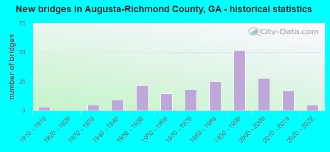
- New bridges - historical statistics
- 31910-1919
- 51930-1939
- 91940-1949
- 221950-1959
- 151960-1969
- 181970-1979
- 251980-1989
- 521990-1999
- 282000-2009
- 172010-2019
- 52020-2022

- Reconstructed bridges - Historical Statistics
- 21960-1969
- 01970-1979
- 101980-1989
- 141990-1999
- 92000-2009


- Bridge Condition - Deck
- 6.8%Very good
- 78.3%Good
- 11.2%Satisfactory
- 3.7%Fair

- Bridge Condition - Superstructure
- 31.7%Very good
- 59.0%Good
- 4.3%Satisfactory
- 3.7%Fair
- 1.2%Poor

- Bridge Condition - Substructure
- 11.2%Very good
- 75.8%Good
- 11.2%Satisfactory
- 1.9%Fair

- Bridge Condition - Channel
- 0.7%Excellent
- 54.7%Very good
- 24.5%Good
- 15.1%Satisfactory
- 3.6%Fair
- 1.4%Poor

- Bridge Condition - Culverts
- 84.2%Good
- 10.5%Satisfactory
- 2.6%Poor
- 2.6%Serious
Find on map >> Show street view
Structure Number: 33003, Location: 13 MI NE OF WAYNESBORO (Lat: 33.225531, Lng: -81.856994), Route carried "on" structure: Spur State highway 56, Year Built: 1958, Year Reconstructed: 1993, Status: Open, Structure Length: 2.74m (8.99ft), Average Daily Traffic: 2,670 (year 2011), Truck Traffic: 1%, Average Future Daily Traffic: 4,005 (year 2031), Design Load: H 15, Features Intersected: BOGGY GUT CREEK
Minimum Vertical Clearance: 30+ m (98+ ft), Kilometerpoint: 9.656, Lanes on structure: 2, Base Highway Network: Yes, Owner: State Highway Agency, Approaching Roadway Width: 7.6m (24.9ft), Material/Design: Concrete, Design/Construction: Tee Beam, Number Of Spans In Main Unit: 3, Length of Maximum Span: 9.1m (29.9ft), Curb-To-Curb Width: 13.4m (44.0ft), Out-to-Out Width: 14.4m (47.2ft)
Condition: Deck: Good, Superstructure: Good, Substructure: Good, Channel: Good, Operating Rating: 39.0 metric tons, Method Used To Determine Operating Rating: Allowable Stress (AS), Inventory Rating: 20.8 metric tons, Method Used To Determine Inventory Rating: Allowable Stress (AS), Structural Evaluation: Somewhat better than minimum adequacy, Deck Geometry: Better than present minimum criteria, Waterway Adequacy: Equal to present desirable criteria, Approach Roadway Alignment: Equal to present desirable criteria, Designated Inspection Frequency: Every 24 months, Inspection Date: June 2020, Bridge Improvement Cost: $352,000, Roadway Improvement Cost: $35,000, Total Project Cost: $527,000, Deck Structure Type: Concrete Cast-file-Place
Find on map >> Show street view
Structure Number: 335005, Location: 9.7 MI N OF WAYNESBORO (Lat: 33.231192, Lng: -81.999003), Route carried "on" structure: County highway 35, Year Built: 1971, Status: Posted for load, Structure Length: 4.15m (13.62ft), Average Daily Traffic: 600 (year 2011), Truck Traffic: 1%, Average Future Daily Traffic: 900 (year 2031), Design Load: H 15, Features Intersected: McBEAN CREEK, Facility Carried by Structure: OLD WAYNESBORO RD
Minimum Vertical Clearance: 30+ m (98+ ft), Kilometerpoint: 4.828, Lanes on structure: 2, Base Highway Network: Yes, Owner: County Highway Agency, Approaching Roadway Width: 6.1m (20.0ft), Material/Design: Concrete, Design/Construction: Tee Beam, Number Of Spans In Main Unit: 4, Length of Maximum Span: 10.4m (34.1ft), Curb or Sidewalk Widths: Left: 0.2m (0.7ft), Right: 0.2m (0.7ft), Curb-To-Curb Width: 8.2m (26.9ft), Out-to-Out Width: 8.7m (28.5ft)
Condition: Deck: Good, Superstructure: Good, Substructure: Good, Channel: Good, Operating Rating: 31.7 metric tons, Method Used To Determine Operating Rating: Load Factor (LF), Inventory Rating: 19.0 metric tons, Method Used To Determine Inventory Rating: Load Factor (LF), Structural Evaluation: Somewhat better than minimum adequacy, Deck Geometry: Somewhat better than minimum adequacy, Waterway Adequacy: Better than present minimum criteria, Approach Roadway Alignment: Better than present minimum criteria, Bridge Posting: Required (Relationship of Operating Rating to Maximum Legal Load: 0.1 - 9.9% below), Designated Inspection Frequency: Every 24 months, Underwater Inspection Frequency: Every 60 months, Inspection Date: June 2020, Underwater Inspection Date: August 2021, Bridge Improvement Cost: $531,000, Roadway Improvement Cost: $53,000, Total Project Cost: $797,000, Deck Structure Type: Concrete Cast-file-Place
Find on map >> Show street view
Structure Number: 335038, Location: 3.7 MI E OF KEYSVILLE (Lat: 33.247439, Lng: -82.169558), Route carried "on" structure: County highway 456, Year Built: 1972, Status: Open, Structure Length: 0.91m (2.99ft), Average Daily Traffic: 600 (year 2011), Truck Traffic: 1%, Average Future Daily Traffic: 900 (year 2031), Design Load: HS 20+Mod, Features Intersected: SPRING HILL BRANCH, Facility Carried by Structure: SPRINGHILL CH ROAD
Minimum Vertical Clearance: 30+ m (98+ ft), Kilometerpoint: 24.140, Lanes on structure: 2, Base Highway Network: Yes, Owner: County Highway Agency, Approaching Roadway Width: 6.1m (20.0ft), Skew: 4 degrees, Material/Design: Concrete, Design/Construction: Culvert, Number Of Spans In Main Unit: 2, Length of Maximum Span: 4.3m (14.1ft)
Condition: Channel: Satisfactory, Culverts: Good, Operating Rating: 55.3 metric tons, Method Used To Determine Operating Rating: Field evaluation and documented engineering judgment, Inventory Rating: 32.6 metric tons, Method Used To Determine Inventory Rating: Field evaluation and documented engineering judgment, Structural Evaluation: Better than present minimum criteria, Waterway Adequacy: Equal to present desirable criteria, Approach Roadway Alignment: Equal to present desirable criteria, Designated Inspection Frequency: Every 24 months, Inspection Date: June 2020, Bridge Improvement Cost: $117,000, Roadway Improvement Cost: $12,000, Total Project Cost: $176,000
Find on map >> Show street view
Structure Number: 335044, Location: 11.2 MI NE OF WAYNESBORO (Lat: 33.242050, Lng: -81.947261), Route carried "on" structure: State highway 56, Year Built: 2001, Status: Open, Structure Length: 9.75m (31.99ft), Average Daily Traffic: 6,360 (year 2011), Truck Traffic: 1%, Average Future Daily Traffic: 9,540 (year 2031), Design Load: HS 20+Mod, Features Intersected: McBEAN CREEK
Minimum Vertical Clearance: 30+ m (98+ ft), Kilometerpoint: 57.936, Lanes on structure: 5, Base Highway Network: Yes, Owner: State Highway Agency, Approaching Roadway Width: 20.7m (67.9ft), Material/Design: Prestressed concrete, Design/Construction: Stringer/Multi-beam, Number Of Spans In Main Unit: 8, Length of Maximum Span: 12.2m (40.0ft), Curb-To-Curb Width: 25.0m (82.0ft), Out-to-Out Width: 25.9m (85.0ft)
Condition: Deck: Good, Superstructure: Good, Substructure: Good, Channel: Very good, Operating Rating: 51.7 metric tons, Method Used To Determine Operating Rating: Allowable Stress (AS), Inventory Rating: 32.6 metric tons, Method Used To Determine Inventory Rating: Allowable Stress (AS), Structural Evaluation: Better than present minimum criteria, Deck Geometry: Superior to present desirable criteria, Waterway Adequacy: Equal to present desirable criteria, Approach Roadway Alignment: Equal to present desirable criteria, Designated Inspection Frequency: Every 24 months, Inspection Date: June 2020, Bridge Improvement Cost: $2,273,000, Roadway Improvement Cost: $227,000, Total Project Cost: $3,410,000, Deck Structure Type: Concrete Cast-file-Place
Find on map >> Show street view
Structure Number: 335047, Location: 10.2 MI N OF WAYNESBORO (Lat: 33.236564, Lng: -82.045333), Route carried "on" structure: US 25, Year Built: 2005, Status: Open, Structure Length: 6.00m (19.69ft), Average Daily Traffic: 8,030 (year 2011), Truck Traffic: 1%, Average Future Daily Traffic: 12,045 (year 2031), Design Load: HS 20+Mod, Features Intersected: McBEAN CREEK
Minimum Vertical Clearance: 30+ m (98+ ft), Kilometerpoint: 35.406, Lanes on structure: 2, Base Highway Network: Yes, Owner: State Highway Agency, Approaching Roadway Width: 12.2m (40.0ft), Skew: 11 degrees, Material/Design: Prestressed concrete, Design/Construction: Stringer/Multi-beam, Number Of Spans In Main Unit: 5, Length of Maximum Span: 11.9m (39.0ft), Curb-To-Curb Width: 11.4m (37.4ft), Out-to-Out Width: 12.5m (41.0ft)
Condition: Deck: Good, Superstructure: Very good, Substructure: Good, Channel: Very good, Operating Rating: 50.8 metric tons, Method Used To Determine Operating Rating: Allowable Stress (AS), Inventory Rating: 32.6 metric tons, Method Used To Determine Inventory Rating: Allowable Stress (AS), Structural Evaluation: Better than present minimum criteria, Deck Geometry: Meets minimum limits, Waterway Adequacy: Equal to present desirable criteria, Approach Roadway Alignment: Equal to present desirable criteria, Designated Inspection Frequency: Every 24 months, Inspection Date: June 2020, Bridge Improvement Cost: $770,000, Roadway Improvement Cost: $77,000, Total Project Cost: $1,155,000, Deck Structure Type: Concrete Cast-file-Place
Find on map >> Show street view
Structure Number: 335052, Location: 10.2 MI N OF WAYNESBORO (Lat: 33.236497, Lng: -82.045100), Route carried "on" structure: US 25, Year Built: 2007, Status: Open, Structure Length: 6.00m (19.69ft), Average Daily Traffic: 8,030 (year 2011), Truck Traffic: 1%, Average Future Daily Traffic: 12,045 (year 2031), Design Load: HS 20+Mod, Features Intersected: MCBEAN CREEK
Minimum Vertical Clearance: 30+ m (98+ ft), Kilometerpoint: 35.406, Lanes on structure: 2, Base Highway Network: Yes, Owner: State Highway Agency, Approaching Roadway Width: 9.8m (32.2ft), Skew: 11 degrees, Material/Design: Prestressed concrete, Design/Construction: Stringer/Multi-beam, Number Of Spans In Main Unit: 5, Length of Maximum Span: 11.9m (39.0ft), Curb-To-Curb Width: 11.4m (37.4ft), Out-to-Out Width: 12.5m (41.0ft)
Condition: Deck: Good, Superstructure: Very good, Substructure: Very good, Channel: Very good, Operating Rating: 50.8 metric tons, Method Used To Determine Operating Rating: Allowable Stress (AS), Inventory Rating: 32.6 metric tons, Method Used To Determine Inventory Rating: Allowable Stress (AS), Structural Evaluation: Equal to present desirable criteria, Deck Geometry: Equal to present minimum criteria, Waterway Adequacy: Equal to present desirable criteria, Approach Roadway Alignment: Equal to present desirable criteria, Designated Inspection Frequency: Every 24 months, Inspection Date: June 2020, Bridge Improvement Cost: $770,000, Roadway Improvement Cost: $77,000, Total Project Cost: $1,155,000, Deck Structure Type: Concrete Cast-file-Place
Find on map >> Show street view
Structure Number: 490032, Location: 6 MI S OF JCT SR 94 (Lat: 30.441400, Lng: -82.198250), Route carried "on" structure: State highway 185, Year Built: 1961, Status: Open, Structure Length: 1.40m (4.59ft), Average Daily Traffic: 740 (year 2012), Truck Traffic: 1%, Average Future Daily Traffic: 1,110 (year 2032), Design Load: HS 20+Mod, Features Intersected: BARBER BRANCH
Minimum Vertical Clearance: 30+ m (98+ ft), Kilometerpoint: 11.265, Lanes on structure: 2, Base Highway Network: Yes, Owner: State Highway Agency, Approaching Roadway Width: 7.6m (24.9ft), Material/Design: Concrete, Design/Construction: Culvert, Number Of Spans In Main Unit: 4, Length of Maximum Span: 3.0m (9.8ft)
Condition: Channel: Satisfactory, Culverts: Good, Operating Rating: 81.6 metric tons, Method Used To Determine Operating Rating: Load Factor (LF), Inventory Rating: 48.9 metric tons, Method Used To Determine Inventory Rating: Load Factor (LF), Structural Evaluation: Better than present minimum criteria, Waterway Adequacy: Equal to present desirable criteria, Approach Roadway Alignment: Equal to present desirable criteria, Designated Inspection Frequency: Every 24 months, Inspection Date: July 2021, Bridge Improvement Cost: $180,000, Roadway Improvement Cost: $18,000, Total Project Cost: $270,000
Find on map >> Show street view
Structure Number: 490034, Location: 2.5 MI S OF JCT SR 94 (Lat: 30.491900, Lng: -82.199378), Route carried "on" structure: State highway 185, Year Built: 1961, Status: Open, Structure Length: 2.56m (8.40ft), Average Daily Traffic: 350 (year 2012), Truck Traffic: 1%, Average Future Daily Traffic: 525 (year 2032), Design Load: H 15, Features Intersected: JACQUIN CREEK
Minimum Vertical Clearance: 30+ m (98+ ft), Kilometerpoint: 17.703, Lanes on structure: 2, Base Highway Network: Yes, Owner: State Highway Agency, Approaching Roadway Width: 7.9m (25.9ft), Material/Design: Concrete, Design/Construction: Tee Beam, Number Of Spans In Main Unit: 3, Length of Maximum Span: 8.5m (27.9ft), Curb or Sidewalk Widths: Left: 0.6m (2.0ft), Right: 0.6m (2.0ft), Curb-To-Curb Width: 7.9m (25.9ft), Out-to-Out Width: 9.8m (32.2ft)
Condition: Deck: Good, Superstructure: Good, Substructure: Good, Channel: Good, Operating Rating: 32.6 metric tons, Method Used To Determine Operating Rating: Load Factor (LF), Inventory Rating: 19.0 metric tons, Method Used To Determine Inventory Rating: Load Factor (LF), Structural Evaluation: Somewhat better than minimum adequacy, Deck Geometry: Somewhat better than minimum adequacy, Waterway Adequacy: Equal to present desirable criteria, Approach Roadway Alignment: Equal to present desirable criteria, Designated Inspection Frequency: Every 24 months, Inspection Date: July 2021, Bridge Improvement Cost: $328,000, Roadway Improvement Cost: $33,000, Total Project Cost: $492,000, Deck Structure Type: Concrete Cast-file-Place, Wearing Surface/Protective System: Wearing Surface: Bituminous
Find on map >> Show street view
Structure Number: 490038, Location: CHARLTON-CAMDEN CO LINE (Lat: 30.945528, Lng: -81.899000), Route carried "on" structure: State highway 252, Year Built: 1956, Status: Open, Structure Length: 24.48m (80.31ft), Average Daily Traffic: 530 (year 2012), Truck Traffic: 1%, Average Future Daily Traffic: 795 (year 2032), Design Load: HS 20, Features Intersected: SATILLA RIVER, Facility Carried by Structure: ALVA J HOPKIN BR.
Minimum Vertical Clearance: 30+ m (98+ ft), Kilometerpoint: 17.703, Lanes on structure: 2, Base Highway Network: Yes, Owner: State Highway Agency, Approaching Roadway Width: 8.5m (27.9ft), Material/Design: Steel continuous, Design/Construction: Stringer/Multi-beam, Number Of Spans In Main Unit: 8, Length of Maximum Span: 46.9m (153.9ft), Curb or Sidewalk Widths: Left: 0.6m (2.0ft), Right: 0.6m (2.0ft), Curb-To-Curb Width: 8.5m (27.9ft), Out-to-Out Width: 10.5m (34.4ft)
Condition: Deck: Good, Superstructure: Good, Substructure: Satisfactory, Channel: Very good, Operating Rating: 62.5 metric tons, Method Used To Determine Operating Rating: Load Factor (LF), Inventory Rating: 37.1 metric tons, Method Used To Determine Inventory Rating: Load Factor (LF), Structural Evaluation: Equal to present minimum criteria, Deck Geometry: Somewhat better than minimum adequacy, Waterway Adequacy: Equal to present desirable criteria, Approach Roadway Alignment: Equal to present desirable criteria, Designated Inspection Frequency: Every 24 months, Underwater Inspection Frequency: Every 60 months, Other Special Inspection Frequency: Every 24 months, Inspection Date: June 2021, Underwater Inspection Date: May 2020, Other Special Inspection Date: June 2021, Bridge Improvement Cost: $3,137,000, Roadway Improvement Cost: $314,000, Total Project Cost: $4,706,000, Deck Structure Type: Concrete Cast-file-Place
Find on map >> Show street view
Structure Number: 490049, Location: 5 MI S OF ST GEORGE (Lat: 30.640069, Lng: -82.056428), Route carried "on" structure: State highway 23, Year Built: 1989, Status: Open, Structure Length: 7.32m (24.02ft), Average Daily Traffic: 910 (year 2012), Truck Traffic: 1%, Average Future Daily Traffic: 1,365 (year 2032), Design Load: HS 20+Mod, Features Intersected: HARRIS CREEK
Minimum Vertical Clearance: 30+ m (98+ ft), Kilometerpoint: 33.796, Lanes on structure: 2, Base Highway Network: Yes, Owner: State Highway Agency, Approaching Roadway Width: 7.6m (24.9ft), Material/Design: Concrete, Design/Construction: Tee Beam, Number Of Spans In Main Unit: 6, Length of Maximum Span: 12.2m (40.0ft), Curb-To-Curb Width: 11.6m (38.1ft), Out-to-Out Width: 12.6m (41.3ft)
Condition: Deck: Good, Superstructure: Good, Substructure: Good, Channel: Good, Operating Rating: 58.9 metric tons, Method Used To Determine Operating Rating: Load Factor (LF), Inventory Rating: 35.3 metric tons, Method Used To Determine Inventory Rating: Load Factor (LF), Structural Evaluation: Better than present minimum criteria, Deck Geometry: Better than present minimum criteria, Waterway Adequacy: Equal to present desirable criteria, Approach Roadway Alignment: Equal to present desirable criteria, Designated Inspection Frequency: Every 24 months, Inspection Date: July 2021, Bridge Improvement Cost: $938,000, Roadway Improvement Cost: $94,000, Total Project Cost: $1,407,000, Deck Structure Type: Concrete Cast-file-Place
Find on map >> Show street view
Structure Number: 735017, Location: 0.1 MI W OF GORDON HWY (Lat: 33.429564, Lng: -82.195294), Route carried "on" structure: County highway 1314, Year Built: 2005, Status: Open, Structure Length: 6.10m (20.01ft), Average Daily Traffic: 940 (year 2012), Truck Traffic: 1%, Average Future Daily Traffic: 1,410 (year 2032), Design Load: HS 20+Mod, Features Intersected: CSX RAILROAD, Facility Carried by Structure: PARHAM ROAD
Minimum Vertical Clearance: 30+ m (98+ ft), Kilometerpoint: 1.609, Lanes on structure: 2, Base Highway Network: Yes, Owner: County Highway Agency, Approaching Roadway Width: 7.3m (24.0ft), Skew: 2 degrees, Material/Design: Prestressed concrete, Design/Construction: Stringer/Multi-beam, Number Of Spans In Main Unit: 3, Length of Maximum Span: 24.1m (79.1ft), Curb-To-Curb Width: 8.5m (27.9ft), Out-to-Out Width: 9.5m (31.2ft)
Condition: Deck: Good, Superstructure: Very good, Substructure: Good, Operating Rating: 61.6 metric tons, Method Used To Determine Operating Rating: Load Factor (LF), Inventory Rating: 35.3 metric tons, Method Used To Determine Inventory Rating: Load Factor (LF), Structural Evaluation: Better than present minimum criteria, Deck Geometry: Somewhat better than minimum adequacy, Underclear: Equal to present minimum criteria, Approach Roadway Alignment: Equal to present desirable criteria, Designated Inspection Frequency: Every 24 months, Inspection Date: June 2021, Bridge Improvement Cost: $781,000, Roadway Improvement Cost: $78,000, Total Project Cost: $1,172,000, Deck Structure Type: Concrete Cast-file-Place
Find on map >> Show street view
Structure Number: 1630009, Location: 7 MI NE OF WRENS (Lat: 33.277639, Lng: -82.296719), Route carried "on" structure: US 1, Year Built: 1952, Year Reconstructed: 2002, Status: Open, Structure Length: 22.07m (72.41ft), Average Daily Traffic: 5,260 (year 2011), Truck Traffic: 19%, Average Future Daily Traffic: 7,890 (year 2031), Design Load: H 20, Features Intersected: BRIER CREEK
Minimum Vertical Clearance: 30+ m (98+ ft), Kilometerpoint: 62.764, Lanes on structure: 2, Base Highway Network: Yes, Owner: State Highway Agency, Approaching Roadway Width: 12.5m (41.0ft), Skew: 10 degrees, Material/Design: Steel continuous, Design/Construction: Stringer/Multi-beam, Number Of Spans In Main Unit: 18, Length of Maximum Span: 12.8m (42.0ft), Curb-To-Curb Width: 11.6m (38.1ft), Out-to-Out Width: 12.6m (41.3ft)
Condition: Deck: Satisfactory, Superstructure: Good, Substructure: Good, Channel: Good, Operating Rating: 29.9 metric tons, Method Used To Determine Operating Rating: Load Factor (LF), Inventory Rating: 18.1 metric tons, Method Used To Determine Inventory Rating: Load Factor (LF), Structural Evaluation: Meets minimum limits, Deck Geometry: Better than present minimum criteria, Waterway Adequacy: Equal to present desirable criteria, Approach Roadway Alignment: Equal to present desirable criteria, Length Of Structure Improvement: 62.27m (204.30ft), Designated Inspection Frequency: Every 24 months, Underwater Inspection Frequency: Every 60 months, Inspection Date: May 2020, Underwater Inspection Date: August 2021, Bridge Improvement Cost: $2,829,000, Roadway Improvement Cost: $283,000, Total Project Cost: $4,243,000, Deck Structure Type: Concrete Precast Panels
Find on map >> Show street view
Structure Number: 1635054, Location: 7 MI NE OF WRENS (Lat: 33.277700, Lng: -82.296858), Route carried "on" structure: US 1, Year Built: 2001, Status: Open, Structure Length: 21.95m (72.01ft), Average Daily Traffic: 5,260 (year 2011), Truck Traffic: 19%, Average Future Daily Traffic: 7,890 (year 2031), Design Load: HS 20+Mod, Features Intersected: BRIER CREEK
Minimum Vertical Clearance: 30+ m (98+ ft), Kilometerpoint: 62.764, Lanes on structure: 2, Base Highway Network: Yes, Owner: State Highway Agency, Approaching Roadway Width: 10.4m (34.1ft), Skew: 10 degrees, Material/Design: Prestressed concrete, Design/Construction: Stringer/Multi-beam, Number Of Spans In Main Unit: 9, Length of Maximum Span: 24.4m (80.1ft), Curb-To-Curb Width: 11.6m (38.1ft), Out-to-Out Width: 12.6m (41.3ft)
Condition: Deck: Good, Superstructure: Good, Substructure: Good, Channel: Very good, Operating Rating: 55.3 metric tons, Method Used To Determine Operating Rating: Load Factor (LF), Inventory Rating: 32.6 metric tons, Method Used To Determine Inventory Rating: Load Factor (LF), Structural Evaluation: Better than present minimum criteria, Deck Geometry: Better than present minimum criteria, Waterway Adequacy: Equal to present desirable criteria, Approach Roadway Alignment: Equal to present desirable criteria, Designated Inspection Frequency: Every 24 months, Underwater Inspection Frequency: Every 60 months, Inspection Date: May 2020, Underwater Inspection Date: August 2021, Bridge Improvement Cost: $2,813,000, Roadway Improvement Cost: $281,000, Total Project Cost: $4,220,000, Deck Structure Type: Concrete Cast-file-Place
Find on map >> Show street view
Structure Number: 1895018, Location: 5.3 MI S OF DEARING (Lat: 33.340828, Lng: -82.353739), Route carried "on" structure: US 221, Year Built: 2006, Status: Open, Structure Length: 4.88m (16.01ft), Average Daily Traffic: 1,420 (year 2011), Truck Traffic: 1%, Average Future Daily Traffic: 2,130 (year 2031), Design Load: HS 20+Mod, Features Intersected: HEADSTALL CREEK
Minimum Vertical Clearance: 30+ m (98+ ft), Kilometerpoint: 6.437, Lanes on structure: 2, Base Highway Network: Yes, Owner: State Highway Agency, Approaching Roadway Width: 8.8m (28.9ft), Material/Design: Prestressed concrete, Design/Construction: Stringer/Multi-beam, Number Of Spans In Main Unit: 4, Length of Maximum Span: 12.2m (40.0ft), Curb-To-Curb Width: 12.2m (40.0ft), Out-to-Out Width: 13.2m (43.3ft)
Condition: Deck: Good, Superstructure: Very good, Substructure: Very good, Channel: Very good, Operating Rating: 35.3 metric tons, Method Used To Determine Operating Rating: Load Factor (LF), Inventory Rating: 20.8 metric tons, Method Used To Determine Inventory Rating: Load Factor (LF), Structural Evaluation: Somewhat better than minimum adequacy, Deck Geometry: Better than present minimum criteria, Waterway Adequacy: Equal to present desirable criteria, Approach Roadway Alignment: Equal to present desirable criteria, Designated Inspection Frequency: Every 24 months, Inspection Date: January 2021, Bridge Improvement Cost: $625,000, Roadway Improvement Cost: $63,000, Total Project Cost: $938,000, Deck Structure Type: Concrete Cast-file-Place
Find on map >> Show street view
Structure Number: 1895028, Location: 7 MI SW OF DEARING (Lat: 33.311478, Lng: -82.375508), Route carried "on" structure: US 221, Year Built: 2015, Status: Open, Structure Length: 13.72m (45.01ft), Average Daily Traffic: 1,420 (year 2015), Truck Traffic: 1%, Average Future Daily Traffic: 3,000 (year 2035), Design Load: HL 93, Features Intersected: BIG BRIER CREEK
Minimum Vertical Clearance: 30+ m (98+ ft), Kilometerpoint: 9.656, Lanes on structure: 2, Base Highway Network: Yes, Owner: State Highway Agency, Approaching Roadway Width: 8.8m (28.9ft), Material/Design: Prestressed concrete, Design/Construction: Stringer/Multi-beam, Number Of Spans In Main Unit: 9, Length of Maximum Span: 15.2m (49.9ft), Curb-To-Curb Width: 12.2m (40.0ft), Out-to-Out Width: 13.2m (43.3ft)
Condition: Deck: Good, Superstructure: Very good, Substructure: Good, Channel: Very good, Operating Rating: 69.8 metric tons, Method Used To Determine Operating Rating: Load Factor (LF), Inventory Rating: 42.6 metric tons, Method Used To Determine Inventory Rating: Load Factor (LF), Structural Evaluation: Better than present minimum criteria, Deck Geometry: Better than present minimum criteria, Waterway Adequacy: Equal to present desirable criteria, Approach Roadway Alignment: Equal to present desirable criteria, Length Of Structure Improvement: 16.46m (54.00ft), Designated Inspection Frequency: Every 24 months, Underwater Inspection Frequency: Every 60 months, Inspection Date: January 2021, Underwater Inspection Date: October 2021, Bridge Improvement Cost: $39,960,000, Roadway Improvement Cost: $3,996,000, Total Project Cost: $59,940,000 ( Estimate for 2016), Deck Structure Type: Concrete Cast-file-Place
Find on map >> Show street view
Structure Number: 2450003, Location: 2.6 MI W OF BLYTHE (Lat: 33.300525, Lng: -82.248700), Route carried "on" structure: US 1, Year Built: 1949, Year Reconstructed: 2002, Status: Open, Structure Length: 0.91m (2.99ft), Average Daily Traffic: 6,260 (year 2012), Truck Traffic: 1%, Average Future Daily Traffic: 9,390 (year 2032), Design Load: H 15, Features Intersected: SANDY RUN CREEK TRIB
Minimum Vertical Clearance: 30+ m (98+ ft), Kilometerpoint: 4.828, Lanes on structure: 4, Base Highway Network: Yes, Owner: State Highway Agency, Approaching Roadway Width: 19.5m (64.0ft), Skew: 14 degrees, Material/Design: Concrete, Design/Construction: Culvert, Number Of Spans In Main Unit: 3, Length of Maximum Span: 2.7m (8.9ft)
Condition: Channel: Satisfactory, Culverts: Good, Operating Rating: 41.7 metric tons, Method Used To Determine Operating Rating: Field evaluation and documented engineering judgment, Inventory Rating: 24.4 metric tons, Method Used To Determine Inventory Rating: Field evaluation and documented engineering judgment, Structural Evaluation: Equal to present minimum criteria, Waterway Adequacy: Equal to present desirable criteria, Approach Roadway Alignment: Equal to present desirable criteria, Designated Inspection Frequency: Every 24 months, Inspection Date: October 2021, Bridge Improvement Cost: $181,000, Roadway Improvement Cost: $18,000, Total Project Cost: $272,000
Find on map >> Show street view
Structure Number: 2450005, Location: 4.7 MI NW OF HEPHZIBAH (Lat: 33.373258, Lng: -82.138878), Route carried "on" structure: US 1, Year Built: 1952, Year Reconstructed: 1991, Status: Open, Structure Length: 3.26m (10.70ft), Average Daily Traffic: 10,140 (year 2012), Truck Traffic: 12%, Average Future Daily Traffic: 15,210 (year 2032), Design Load: H 20, Features Intersected: NORTH FORK SPIRIT CREEK
Minimum Vertical Clearance: 30+ m (98+ ft), Kilometerpoint: 19.312, Lanes on structure: 2, Base Highway Network: Yes, Owner: State Highway Agency, Approaching Roadway Width: 9.8m (32.2ft), Skew: 10 degrees, Material/Design: Steel continuous, Design/Construction: Stringer/Multi-beam, Number Of Spans In Main Unit: 3, Length of Maximum Span: 12.2m (40.0ft), Curb-To-Curb Width: 11.8m (38.7ft), Out-to-Out Width: 12.9m (42.3ft)
Condition: Deck: Satisfactory, Superstructure: Good, Substructure: Good, Channel: Good, Operating Rating: 30.8 metric tons, Method Used To Determine Operating Rating: Load Factor (LF), Inventory Rating: 18.1 metric tons, Method Used To Determine Inventory Rating: Load Factor (LF), Structural Evaluation: Meets minimum limits, Deck Geometry: Better than present minimum criteria, Waterway Adequacy: Equal to present desirable criteria, Approach Roadway Alignment: Better than present minimum criteria, Designated Inspection Frequency: Every 24 months, Inspection Date: November 2021, Bridge Improvement Cost: $418,000, Roadway Improvement Cost: $42,000, Total Project Cost: $627,000, Deck Structure Type: Concrete Cast-file-Place
Find on map >> Show street view
Structure Number: 2450006, Location: 7 MI N OF HEPHZIBAH (Lat: 33.413028, Lng: -82.087125), Route carried "on" structure: US 1, Year Built: 1962, Year Reconstructed: 2003, Status: Open, Structure Length: 3.26m (10.70ft), Average Daily Traffic: 19,080 (year 2012), Truck Traffic: 8%, Average Future Daily Traffic: 28,620 (year 2032), Design Load: HS 20+Mod, Features Intersected: BUTLER CREEK
Minimum Vertical Clearance: 30+ m (98+ ft), Kilometerpoint: 27.359, Lanes on structure: 2, Base Highway Network: Yes, Owner: State Highway Agency, Approaching Roadway Width: 9.1m (29.9ft), Skew: 10 degrees, Material/Design: Concrete, Design/Construction: Tee Beam, Number Of Spans In Main Unit: 3, Length of Maximum Span: 12.2m (40.0ft), Curb-To-Curb Width: 11.6m (38.1ft), Out-to-Out Width: 12.6m (41.3ft)
Condition: Deck: Good, Superstructure: Good, Substructure: Good, Channel: Very good, Operating Rating: 44.4 metric tons, Method Used To Determine Operating Rating: Load Factor (LF), Inventory Rating: 26.3 metric tons, Method Used To Determine Inventory Rating: Load Factor (LF), Structural Evaluation: Equal to present minimum criteria, Deck Geometry: Better than present minimum criteria, Waterway Adequacy: Equal to present desirable criteria, Approach Roadway Alignment: Equal to present desirable criteria, Designated Inspection Frequency: Every 24 months, Inspection Date: December 2021, Bridge Improvement Cost: $418,000, Roadway Improvement Cost: $42,000, Total Project Cost: $627,000, Deck Structure Type: Concrete Cast-file-Place
Find on map >> Show street view
Structure Number: 2450007, Location: 7 MI N OF HEPHZIBAH (Lat: 33.413111, Lng: -82.087328), Route carried "on" structure: US 1, Year Built: 1952, Year Reconstructed: 2003, Status: Open, Structure Length: 3.26m (10.70ft), Average Daily Traffic: 19,080 (year 2012), Truck Traffic: 8%, Average Future Daily Traffic: 28,620 (year 2032), Design Load: HS 20+Mod, Features Intersected: BUTLER CREEK
Minimum Vertical Clearance: 30+ m (98+ ft), Kilometerpoint: 27.359, Lanes on structure: 2, Base Highway Network: Yes, Owner: State Highway Agency, Approaching Roadway Width: 9.1m (29.9ft), Skew: 10 degrees, Material/Design: Steel continuous, Design/Construction: Stringer/Multi-beam, Number Of Spans In Main Unit: 3, Length of Maximum Span: 12.2m (40.0ft), Curb-To-Curb Width: 11.6m (38.1ft), Out-to-Out Width: 12.6m (41.3ft)
Condition: Deck: Good, Superstructure: Good, Substructure: Good, Channel: Very good, Operating Rating: 34.4 metric tons, Method Used To Determine Operating Rating: Load Factor (LF), Inventory Rating: 20.8 metric tons, Method Used To Determine Inventory Rating: Load Factor (LF), Structural Evaluation: Somewhat better than minimum adequacy, Deck Geometry: Better than present minimum criteria, Waterway Adequacy: Equal to present desirable criteria, Approach Roadway Alignment: Equal to present desirable criteria, Designated Inspection Frequency: Every 24 months, Inspection Date: December 2021, Bridge Improvement Cost: $418,000, Roadway Improvement Cost: $42,000, Total Project Cost: $627,000, Deck Structure Type: Concrete Cast-file-Place
Find on map >> Show street view
Structure Number: 2450008, Location: 9.4 MI NE OF HEPHZIBAH (Lat: 33.438181, Lng: -82.025544), Route carried "on" structure: US 1, Year Built: 1962, Status: Open, Structure Length: 2.29m (7.51ft), Average Daily Traffic: 20,230 (year 2012), Truck Traffic: 1%, Average Future Daily Traffic: 30,345 (year 2032), Design Load: HS 20+Mod, Features Intersected: ROCKY CREEK
Minimum Vertical Clearance: 30+ m (98+ ft), Kilometerpoint: 33.796, Lanes on structure: 7, Base Highway Network: Yes, Owner: State Highway Agency, Approaching Roadway Width: 25.0m (82.0ft), Skew: 10 degrees, Material/Design: Steel continuous, Design/Construction: Stringer/Multi-beam, Number Of Spans In Main Unit: 3, Length of Maximum Span: 8.5m (27.9ft), Curb or Sidewalk Widths: Left: 1.5m (4.9ft), Right: 1.5m (4.9ft), Curb-To-Curb Width: 24.4m (80.1ft), Out-to-Out Width: 29.4m (96.5ft)
Condition: Deck: Satisfactory, Superstructure: Good, Substructure: Good, Channel: Satisfactory, Operating Rating: 52.6 metric tons, Method Used To Determine Operating Rating: Load Factor (LF), Inventory Rating: 30.8 metric tons, Method Used To Determine Inventory Rating: Load Factor (LF), Structural Evaluation: Better than present minimum criteria, Deck Geometry: High priority of replacement, Waterway Adequacy: Equal to present desirable criteria, Approach Roadway Alignment: Equal to present desirable criteria, Designated Inspection Frequency: Every 24 months, Inspection Date: January 2022, Bridge Improvement Cost: $693,000, Roadway Improvement Cost: $69,000, Total Project Cost: $1,039,000, Deck Structure Type: Concrete Cast-file-Place
Find on map >> Show street view
Structure Number: 245001, Location: 8.8 MI N OF HEPHZIBAH (Lat: 33.441433, Lng: -82.127519), Route carried "on" structure: US 78, Year Built: 1969, Year Reconstructed: 1999, Status: Open, Structure Length: 1.34m (4.40ft), Average Daily Traffic: 15,150 (year 2012), Truck Traffic: 7%, Average Future Daily Traffic: 22,725 (year 2032), Design Load: HS 20+Mod, Features Intersected: BUTLER CREEK
Minimum Vertical Clearance: 30+ m (98+ ft), Kilometerpoint: 9.656, Lanes on structure: 5, Base Highway Network: Yes, Owner: State Highway Agency, Approaching Roadway Width: 26.8m (87.9ft), Skew: 10 degrees, Material/Design: Concrete, Design/Construction: Culvert, Number Of Spans In Main Unit: 4, Length of Maximum Span: 3.0m (9.8ft)
Condition: Channel: Satisfactory, Culverts: Good, Operating Rating: 55.3 metric tons, Method Used To Determine Operating Rating: Field evaluation and documented engineering judgment, Inventory Rating: 32.6 metric tons, Method Used To Determine Inventory Rating: Field evaluation and documented engineering judgment, Structural Evaluation: Better than present minimum criteria, Waterway Adequacy: Equal to present desirable criteria, Approach Roadway Alignment: Equal to present desirable criteria, Designated Inspection Frequency: Every 24 months, Inspection Date: December 2021, Bridge Improvement Cost: $313,000, Roadway Improvement Cost: $31,000, Total Project Cost: $469,000
Find on map >> Show street view
Structure Number: 2450011, Location: 9.1 MI N OF HEPHZIBAH (Lat: 33.450469, Lng: -82.073539), Route carried "on" structure: US 78, Year Built: 1973, Year Reconstructed: 1992, Status: Open, Structure Length: 8.35m (27.40ft), Average Daily Traffic: 27,880 (year 2012), Truck Traffic: 1%, Average Future Daily Traffic: 41,820 (year 2032), Design Load: HS 20+Mod, Features Intersected: I-520 (SR 415)
Minimum Vertical Clearance: 30+ m (98+ ft), Kilometerpoint: 16.093, Lanes on structure: 8, Lanes under structure: 6, Base Highway Network: Yes, Owner: State Highway Agency, Approaching Roadway Width: 25.3m (83.0ft), Skew: 20 degrees, Material/Design: Steel continuous, Design/Construction: Stringer/Multi-beam, Number Of Spans In Main Unit: 4, Length of Maximum Span: 23.2m (76.1ft), Curb-To-Curb Width: 35.9m (117.8ft), Out-to-Out Width: 38.5m (126.3ft)
Condition: Deck: Satisfactory, Superstructure: Satisfactory, Substructure: Satisfactory, Operating Rating: 63.5 metric tons, Method Used To Determine Operating Rating: Load Factor (LF), Inventory Rating: 39.0 metric tons, Method Used To Determine Inventory Rating: Load Factor (LF), Structural Evaluation: Equal to present minimum criteria, Deck Geometry: Superior to present desirable criteria, Underclear: Equal to present minimum criteria, Approach Roadway Alignment: Equal to present desirable criteria, Designated Inspection Frequency: Every 24 months, Inspection Date: October 2021, Other Special Inspection Date: April 2021, Bridge Improvement Cost: $2,822,000, Roadway Improvement Cost: $282,000, Total Project Cost: $4,234,000, Deck Structure Type: Concrete Cast-file-Place
Find on map >> Show street view
Structure Number: 2450013, Location: 10.5 MI NE OF HEPHZIBAH (Lat: 33.440222, Lng: -81.994394), Route carried "on" structure: US 1, Year Built: 1954, Year Reconstructed: 1988, Status: Open, Structure Length: 8.38m (27.49ft), Average Daily Traffic: 20,740 (year 2012), Truck Traffic: 1%, Average Future Daily Traffic: 31,110 (year 2032), Design Load: HS 20, Features Intersected: NS RR. (734123P)
Minimum Vertical Clearance: 30+ m (98+ ft), Kilometerpoint: 24.140, Lanes on structure: 6, Base Highway Network: Yes, Owner: State Highway Agency, Approaching Roadway Width: 31.4m (103.0ft), Skew: 34 degrees, Material/Design: Steel, Design/Construction: Stringer/Multi-beam, Number Of Spans In Main Unit: 5, Length of Maximum Span: 16.8m (55.1ft), Curb-To-Curb Width: 30.1m (98.8ft), Out-to-Out Width: 32.2m (105.6ft)
Condition: Deck: Satisfactory, Superstructure: Good, Substructure: Good, Operating Rating: 33.5 metric tons, Method Used To Determine Operating Rating: Load Factor (LF), Inventory Rating: 19.9 metric tons, Method Used To Determine Inventory Rating: Load Factor (LF), Structural Evaluation: Somewhat better than minimum adequacy, Deck Geometry: Superior to present desirable criteria, Underclear: Meets minimum limits, Approach Roadway Alignment: Equal to present desirable criteria, Designated Inspection Frequency: Every 24 months, Inspection Date: January 2022, Bridge Improvement Cost: $2,247,000, Roadway Improvement Cost: $225,000, Total Project Cost: $3,370,000, Deck Structure Type: Concrete Cast-file-Place
Find on map >> Show street view
Structure Number: 2450014, Location: 10.8 MI NE OF HEPHZIBAH (Lat: 33.441339, Lng: -81.985525), Route carried "on" structure: US 1, Year Built: 1954, Year Reconstructed: 1987, Status: Open, Structure Length: 7.99m (26.21ft), Average Daily Traffic: 20,740 (year 2012), Truck Traffic: 1%, Average Future Daily Traffic: 31,110 (year 2032), Design Load: HS 20, Features Intersected: NS RR. (732964Y)
Minimum Vertical Clearance: 30+ m (98+ ft), Kilometerpoint: 24.140, Lanes on structure: 6, Base Highway Network: Yes, Owner: State Highway Agency, Approaching Roadway Width: 31.4m (103.0ft), Skew: 32 degrees, Material/Design: Concrete, Design/Construction: Tee Beam, Number Of Spans In Main Unit: 7, Length of Maximum Span: 13.4m (44.0ft), Curb-To-Curb Width: 30.1m (98.8ft), Out-to-Out Width: 32.2m (105.6ft)
Condition: Deck: Satisfactory, Superstructure: Satisfactory, Substructure: Satisfactory, Operating Rating: 54.4 metric tons, Method Used To Determine Operating Rating: Allowable Stress (AS), Inventory Rating: 32.6 metric tons, Method Used To Determine Inventory Rating: Allowable Stress (AS), Structural Evaluation: Equal to present minimum criteria, Deck Geometry: Superior to present desirable criteria, Underclear: Meets minimum limits, Approach Roadway Alignment: Equal to present desirable criteria, Designated Inspection Frequency: Every 24 months, Inspection Date: January 2022, Bridge Improvement Cost: $2,140,000, Roadway Improvement Cost: $214,000, Total Project Cost: $3,211,000, Deck Structure Type: Concrete Cast-file-Place
Find on map >> Show street view
Structure Number: 2450015, Location: 11.3 MI NE OF HEPHZIBAH (Lat: 33.446511, Lng: -81.976700), Route carried "on" structure: US 1, Year Built: 1954, Year Reconstructed: 1987, Status: Open, Structure Length: 5.15m (16.90ft), Average Daily Traffic: 25,920 (year 2012), Truck Traffic: 4%, Average Future Daily Traffic: 38,880 (year 2032), Design Load: HS 20, Features Intersected: CSX RR (279452J)-OATS CR
Minimum Vertical Clearance: 30+ m (98+ ft), Kilometerpoint: 25.750, Lanes on structure: 6, Base Highway Network: Yes, Owner: State Highway Agency, Approaching Roadway Width: 31.4m (103.0ft), Skew: 32 degrees, Material/Design: Steel, Design/Construction: Stringer/Multi-beam, Number Of Spans In Main Unit: 3, Length of Maximum Span: 17.1m (56.1ft), Curb-To-Curb Width: 30.1m (98.8ft), Out-to-Out Width: 32.2m (105.6ft)
Condition: Deck: Good, Superstructure: Good, Substructure: Good, Channel: Very good, Operating Rating: 41.7 metric tons, Method Used To Determine Operating Rating: Load Factor (LF), Inventory Rating: 24.4 metric tons, Method Used To Determine Inventory Rating: Load Factor (LF), Structural Evaluation: Equal to present minimum criteria, Deck Geometry: Superior to present desirable criteria, Underclear: Equal to present minimum criteria, Waterway Adequacy: Equal to present desirable criteria, Approach Roadway Alignment: Equal to present desirable criteria, Designated Inspection Frequency: Every 24 months, Inspection Date: January 2022, Bridge Improvement Cost: $1,381,000, Roadway Improvement Cost: $138,000, Total Project Cost: $2,071,000, Deck Structure Type: Concrete Cast-file-Place
Find on map >> Show street view
Structure Number: 2450016, Location: 12.4 MI NE OF HEPHZIBAH (Lat: 33.461022, Lng: -81.966181), Route carried "on" structure: US 1, Year Built: 1954, Year Reconstructed: 1987, Status: Open, Structure Length: 7.65m (25.10ft), Average Daily Traffic: 25,920 (year 2012), Truck Traffic: 4%, Average Future Daily Traffic: 38,880 (year 2032), Design Load: HS 20, Features Intersected: CR475 L.WALKER-CANAL-RR
Minimum Vertical Clearance: 30+ m (98+ ft), Kilometerpoint: 27.359, Lanes on structure: 6, Lanes under structure: 4, Base Highway Network: Yes, Owner: State Highway Agency, Approaching Roadway Width: 31.4m (103.0ft), Skew: 30 degrees, Material/Design: Steel, Design/Construction: Stringer/Multi-beam, Number Of Spans In Main Unit: 4, Length of Maximum Span: 21.6m (70.9ft), Curb-To-Curb Width: 30.2m (99.1ft), Out-to-Out Width: 32.2m (105.6ft)
Condition: Deck: Good, Superstructure: Good, Substructure: Good, Channel: Very good, Operating Rating: 64.4 metric tons, Method Used To Determine Operating Rating: Load Factor (LF), Inventory Rating: 38.1 metric tons, Method Used To Determine Inventory Rating: Load Factor (LF), Structural Evaluation: Better than present minimum criteria, Deck Geometry: Superior to present desirable criteria, Underclear: High priority of corrective action, Waterway Adequacy: Equal to present desirable criteria, Approach Roadway Alignment: Equal to present desirable criteria, Designated Inspection Frequency: Every 24 months, Inspection Date: November 2021, Bridge Improvement Cost: $2,051,000, Roadway Improvement Cost: $205,000, Total Project Cost: $3,076,000, Deck Structure Type: Concrete Cast-file-Place
Find on map >> Show street view
Structure Number: 2450017, Location: 13.1 MI NE OF HEPHZIBAH (Lat: 33.469269, Lng: -81.958747), Route carried "on" structure: US 1, Year Built: 1957, Year Reconstructed: 2006, Status: Open, Structure Length: 4.66m (15.29ft), Average Daily Traffic: 19,970 (year 2012), Truck Traffic: 1%, Average Future Daily Traffic: 29,955 (year 2032), Design Load: HS 20, Features Intersected: CR 2496 TELFAIR STREET
Minimum Vertical Clearance: 30+ m (98+ ft), Kilometerpoint: 28.968, Lanes on structure: 4, Lanes under structure: 2, Base Highway Network: Yes, Owner: State Highway Agency, Approaching Roadway Width: 17.4m (57.1ft), Skew: 30 degrees, Material/Design: Steel, Design/Construction: Stringer/Multi-beam, Number Of Spans In Main Unit: 3, Length of Maximum Span: 21.0m (68.9ft), Curb-To-Curb Width: 17.4m (57.1ft), Out-to-Out Width: 19.3m (63.3ft)
Condition: Deck: Good, Superstructure: Good, Substructure: Good, Operating Rating: 39.9 metric tons, Method Used To Determine Operating Rating: Load Factor (LF), Inventory Rating: 23.5 metric tons, Method Used To Determine Inventory Rating: Load Factor (LF), Structural Evaluation: Somewhat better than minimum adequacy, Deck Geometry: Somewhat better than minimum adequacy, Underclear: Meets minimum limits, Approach Roadway Alignment: Equal to present desirable criteria, Designated Inspection Frequency: Every 24 months, Inspection Date: November 2021, Bridge Improvement Cost: $924,000, Roadway Improvement Cost: $92,000, Total Project Cost: $1,386,000, Deck Structure Type: Concrete Cast-file-Place
Find on map >> Show street view
Structure Number: 2450018, Location: 13.2 MI NE OF HEPHZIBAH (Lat: 33.470489, Lng: -81.958158), Route carried "on" structure: US 1, Year Built: 1957, Year Reconstructed: 2006, Status: Posted for load, Structure Length: 6.86m (22.51ft), Average Daily Traffic: 19,970 (year 2012), Truck Traffic: 1%, Average Future Daily Traffic: 29,955 (year 2032), Design Load: HS 20, Features Intersected: CR 2495 GREENE STREET
Minimum Vertical Clearance: 30+ m (98+ ft), Kilometerpoint: 28.968, Lanes on structure: 5, Lanes under structure: 4, Base Highway Network: Yes, Owner: State Highway Agency, Approaching Roadway Width: 17.4m (57.1ft), Skew: 30 degrees, Material/Design: Steel continuous, Design/Construction: Stringer/Multi-beam, Number Of Spans In Main Unit: 4, Length of Maximum Span: 20.7m (67.9ft), Curb-To-Curb Width: 20.9m (68.6ft), Out-to-Out Width: 22.9m (75.1ft)
Condition: Deck: Good, Superstructure: Good, Substructure: Satisfactory, Operating Rating: 29.9 metric tons, Method Used To Determine Operating Rating: Load Factor (LF), Inventory Rating: 18.1 metric tons, Method Used To Determine Inventory Rating: Load Factor (LF), Structural Evaluation: Meets minimum limits, Deck Geometry: Meets minimum limits, Underclear: High priority of corrective action, Approach Roadway Alignment: Equal to present desirable criteria, Bridge Posting: Required (Relationship of Operating Rating to Maximum Legal Load: 0.1 - 9.9% below), Designated Inspection Frequency: Every 24 months, Inspection Date: November 2021, Bridge Improvement Cost: $1,598,000, Roadway Improvement Cost: $160,000, Total Project Cost: $2,398,000, Deck Structure Type: Concrete Cast-file-Place
Find on map >> Show street view
Structure Number: 2450019, Location: 13.3 MI NE OF HEPHZIBAH (Lat: 33.471425, Lng: -81.957547), Route carried "on" structure: US 1, Year Built: 1957, Year Reconstructed: 2006, Status: Open, Structure Length: 3.44m (11.29ft), Average Daily Traffic: 19,970 (year 2012), Truck Traffic: 1%, Average Future Daily Traffic: 29,955 (year 2032), Design Load: HS 20, Features Intersected: CR 2494 ELLIS STREET
Minimum Vertical Clearance: 30+ m (98+ ft), Kilometerpoint: 28.968, Lanes on structure: 5, Lanes under structure: 2, Base Highway Network: Yes, Owner: State Highway Agency, Approaching Roadway Width: 17.4m (57.1ft), Skew: 30 degrees, Material/Design: Steel, Design/Construction: Stringer/Multi-beam, Number Of Spans In Main Unit: 3, Length of Maximum Span: 13.7m (44.9ft), Curb-To-Curb Width: 20.9m (68.6ft), Out-to-Out Width: 22.9m (75.1ft)
Condition: Deck: Good, Superstructure: Good, Substructure: Good, Operating Rating: 43.5 metric tons, Method Used To Determine Operating Rating: Load Factor (LF), Inventory Rating: 26.3 metric tons, Method Used To Determine Inventory Rating: Load Factor (LF), Structural Evaluation: Equal to present minimum criteria, Deck Geometry: Meets minimum limits, Underclear: Meets minimum limits, Approach Roadway Alignment: Equal to present desirable criteria, Designated Inspection Frequency: Every 24 months, Inspection Date: November 2021, Bridge Improvement Cost: $803,000, Roadway Improvement Cost: $80,000, Total Project Cost: $1,204,000, Deck Structure Type: Concrete Cast-file-Place
Find on map >> Show street view
Structure Number: 245002, Location: 13.4 MI NE OF HEPHZIBAH (Lat: 33.472381, Lng: -81.957050), Route carried "on" structure: US 1, Year Built: 1957, Year Reconstructed: 2006, Status: Open, Structure Length: 6.77m (22.21ft), Average Daily Traffic: 18,000 (year 2012), Truck Traffic: 6%, Average Future Daily Traffic: 27,000 (year 2032), Design Load: HS 20, Features Intersected: SR 28
Minimum Vertical Clearance: 30+ m (98+ ft), Kilometerpoint: 28.968, Lanes on structure: 5, Lanes under structure: 5, Base Highway Network: Yes, Owner: State Highway Agency, Approaching Roadway Width: 17.4m (57.1ft), Skew: 30 degrees, Material/Design: Steel continuous, Design/Construction: Stringer/Multi-beam, Number Of Spans In Main Unit: 4, Length of Maximum Span: 20.7m (67.9ft), Curb-To-Curb Width: 20.9m (68.6ft), Out-to-Out Width: 22.9m (75.1ft)
Condition: Deck: Good, Superstructure: Good, Substructure: Satisfactory, Operating Rating: 32.6 metric tons, Method Used To Determine Operating Rating: Load Factor (LF), Inventory Rating: 19.0 metric tons, Method Used To Determine Inventory Rating: Load Factor (LF), Structural Evaluation: Meets minimum limits, Deck Geometry: Meets minimum limits, Underclear: Equal to present minimum criteria, Approach Roadway Alignment: Equal to present desirable criteria, Designated Inspection Frequency: Every 24 months, Inspection Date: November 2021, Bridge Improvement Cost: $1,577,000, Roadway Improvement Cost: $158,000, Total Project Cost: $2,366,000, Deck Structure Type: Concrete Cast-file-Place
Find on map >> Show street view
Structure Number: 2450021, Location: 13.5 MI NE OF HEPHZIBAH (Lat: 33.475589, Lng: -81.955397), Route carried "on" structure: US 1, Year Built: 1960, Year Reconstructed: 2006, Status: Open, Structure Length: 36.82m (120.80ft), Average Daily Traffic: 18,000 (year 2012), Truck Traffic: 6%, Average Future Daily Traffic: 27,000 (year 2032), Design Load: HS 20+Mod, Features Intersected: CR2493 - SAVANNAH RIVER
Minimum Vertical Clearance: 30+ m (98+ ft), Kilometerpoint: 28.968, Lanes on structure: 4, Lanes under structure: 2, Base Highway Network: Yes, Owner: State Highway Agency, Approaching Roadway Width: 17.1m (56.1ft), Skew: 30 degrees, Navigation Control: Yes ( Vertical Clearance: 12.1m (39.7ft), Horizontal Clearance: 30.4m (99.7ft)), Material/Design: Steel continuous, Design/Construction: Stringer/Multi-beam, Number Of Spans In Main Unit: 13, Length of Maximum Span: 46.9m (153.9ft), Curb-To-Curb Width: 17.4m (57.1ft), Out-to-Out Width: 19.4m (63.6ft)
Condition: Deck: Good, Superstructure: Good, Substructure: Good, Channel: Good, Operating Rating: 48.9 metric tons, Method Used To Determine Operating Rating: Allowable Stress (AS), Inventory Rating: 31.7 metric tons, Method Used To Determine Inventory Rating: Allowable Stress (AS), Structural Evaluation: Better than present minimum criteria, Deck Geometry: Meets minimum limits, Underclear: High priority of corrective action, Waterway Adequacy: Equal to present desirable criteria, Approach Roadway Alignment: Equal to present desirable criteria, Designated Inspection Frequency: Every 24 months, Underwater Inspection Frequency: Every 60 months, Inspection Date: November 2021, Underwater Inspection Date: July 2021, Bridge Improvement Cost: $7,294,000, Roadway Improvement Cost: $729,000, Total Project Cost: $10,942,000, Deck Structure Type: Concrete Cast-file-Place
Find on map >> Show street view
Structure Number: 2450022, Location: 13.3 MI NE OF HEPHZIBAH (Lat: 33.471214, Lng: -81.956978), Route carried "on" structure: Ramp US 1, Year Built: 1957, Year Reconstructed: 2003, Status: Open, Structure Length: 3.11m (10.20ft), Average Daily Traffic: 1,330 (year 2012), Truck Traffic: 1%, Average Future Daily Traffic: 1,995 (year 2032), Design Load: HS 20+Mod, Features Intersected: CR 2494 ELLIS STREET
Minimum Vertical Clearance: 30+ m (98+ ft), Kilometerpoint: 28.968, Lanes on structure: 1, Lanes under structure: 2, Base Highway Network: Yes, Owner: State Highway Agency, Approaching Roadway Width: 6.1m (20.0ft), Material/Design: Steel, Design/Construction: Stringer/Multi-beam, Number Of Spans In Main Unit: 3, Length of Maximum Span: 13.7m (44.9ft), Curb-To-Curb Width: 6.1m (20.0ft), Out-to-Out Width: 7.1m (23.3ft)
Condition: Deck: Good, Superstructure: Good, Substructure: Good, Operating Rating: 37.1 metric tons, Method Used To Determine Operating Rating: Load Factor (LF), Inventory Rating: 22.6 metric tons, Method Used To Determine Inventory Rating: Load Factor (LF), Structural Evaluation: Equal to present minimum criteria, Deck Geometry: Somewhat better than minimum adequacy, Underclear: Meets minimum limits, Approach Roadway Alignment: Equal to present minimum criteria, Designated Inspection Frequency: Every 24 months, Inspection Date: November 2021, Bridge Improvement Cost: $290,000, Roadway Improvement Cost: $29,000, Total Project Cost: $435,000, Deck Structure Type: Concrete Cast-file-Place
Find on map >> Show street view
Structure Number: 2450023, Location: 13.3 MI NE OF HEPHZIBAH (Lat: 33.471481, Lng: -81.957800), Route carried "on" structure: Ramp US 1, Year Built: 1957, Year Reconstructed: 2005, Status: Open, Structure Length: 3.29m (10.79ft), Average Daily Traffic: 460 (year 2012), Truck Traffic: 1%, Average Future Daily Traffic: 690 (year 2032), Design Load: HS 20+Mod, Features Intersected: CR 2494 ELLIS STREET
Minimum Vertical Clearance: 30+ m (98+ ft), Kilometerpoint: 28.968, Lanes on structure: 1, Lanes under structure: 2, Base Highway Network: Yes, Owner: State Highway Agency, Approaching Roadway Width: 6.1m (20.0ft), Skew: 1 degrees, Material/Design: Steel, Design/Construction: Stringer/Multi-beam, Number Of Spans In Main Unit: 3, Length of Maximum Span: 14.0m (45.9ft), Curb-To-Curb Width: 6.1m (20.0ft), Out-to-Out Width: 7.1m (23.3ft)
Condition: Deck: Good, Superstructure: Very good, Substructure: Good, Operating Rating: 32.6 metric tons, Method Used To Determine Operating Rating: Load Factor (LF), Inventory Rating: 19.0 metric tons, Method Used To Determine Inventory Rating: Load Factor (LF), Structural Evaluation: Somewhat better than minimum adequacy, Deck Geometry: Somewhat better than minimum adequacy, Underclear: Meets minimum limits, Approach Roadway Alignment: Equal to present minimum criteria, Designated Inspection Frequency: Every 24 months, Inspection Date: November 2021, Bridge Improvement Cost: $307,000, Roadway Improvement Cost: $31,000, Total Project Cost: $460,000, Deck Structure Type: Concrete Cast-file-Place
Find on map >> Show street view
Structure Number: 2450025, Location: 13 MI NE OF HEPHZIBAH (Lat: 33.483619, Lng: -81.990989), Route carried "on" structure: County highway 2720, Year Built: 1935, Status: Open, Structure Length: 6.16m (20.21ft), Average Daily Traffic: 3,010 (year 2012), Truck Traffic: 1%, Average Future Daily Traffic: 4,515 (year 2032), Design Load: H 20, Features Intersected: AUGUSTA CANAL, Facility Carried by Structure: BROAD STREET
Minimum Vertical Clearance: 30+ m (98+ ft), Kilometerpoint: 1.609, Lanes on structure: 4, Base Highway Network: Yes, Owner: County Highway Agency, Approaching Roadway Width: 13.4m (44.0ft), Skew: 3 degrees, Material/Design: Steel, Design/Construction: Stringer/Multi-beam, Number Of Spans In Main Unit: 3, Length of Maximum Span: 20.7m (67.9ft), Curb or Sidewalk Widths: Left: 1.5m (4.9ft), Right: 1.5m (4.9ft), Curb-To-Curb Width: 12.1m (39.7ft), Out-to-Out Width: 16.0m (52.5ft)
Condition: Deck: Good, Superstructure: Good, Substructure: Very good, Channel: Satisfactory, Operating Rating: 58.0 metric tons, Method Used To Determine Operating Rating: Load Factor (LF), Inventory Rating: 34.4 metric tons, Method Used To Determine Inventory Rating: Load Factor (LF), Structural Evaluation: Better than present minimum criteria, Deck Geometry: High priority of replacement, Waterway Adequacy: Equal to present desirable criteria, Approach Roadway Alignment: Equal to present desirable criteria, Length Of Structure Improvement: 46.39m (152.20ft), Designated Inspection Frequency: Every 24 months, Underwater Inspection Frequency: Every 60 months, Inspection Date: January 2022, Underwater Inspection Date: July 2021, Bridge Improvement Cost: $1,220,000, Roadway Improvement Cost: $122,000, Total Project Cost: $1,830,000, Deck Structure Type: Concrete Cast-file-Place, Wearing Surface/Protective System: Wearing Surface: Bituminous
Find on map >> Show street view
Structure Number: 2450026, Location: 13.2 MI NE OF HEPHIZIBAH (Lat: 33.492086, Lng: -82.009497), Route carried "on" structure: County highway 2720, Year Built: 1957, Status: Open, Structure Length: 3.47m (11.38ft), Average Daily Traffic: 8,110 (year 2012), Truck Traffic: 2%, Average Future Daily Traffic: 12,165 (year 2032), Design Load: HS 20, Features Intersected: RAES CREEK, Facility Carried by Structure: BROAD STREET
Minimum Vertical Clearance: 30+ m (98+ ft), Kilometerpoint: 0.000, Lanes on structure: 6, Base Highway Network: Yes, Owner: County Highway Agency, Approaching Roadway Width: 22.3m (73.2ft), Skew: 20 degrees, Material/Design: Steel, Design/Construction: Stringer/Multi-beam, Number Of Spans In Main Unit: 3, Length of Maximum Span: 11.6m (38.1ft), Curb or Sidewalk Widths: Left: 1.5m (4.9ft), Right: 1.5m (4.9ft), Curb-To-Curb Width: 21.9m (71.9ft), Out-to-Out Width: 25.5m (83.7ft)
Condition: Deck: Fair, Superstructure: Satisfactory, Substructure: Satisfactory, Channel: Good, Operating Rating: 49.8 metric tons, Method Used To Determine Operating Rating: Allowable Stress (AS), Inventory Rating: 31.7 metric tons, Method Used To Determine Inventory Rating: Allowable Stress (AS), Structural Evaluation: Equal to present minimum criteria, Deck Geometry: High priority of corrective action, Waterway Adequacy: Equal to present desirable criteria, Approach Roadway Alignment: Better than present minimum criteria, Designated Inspection Frequency: Every 24 months, Inspection Date: January 2022, Bridge Improvement Cost: $931,000, Roadway Improvement Cost: $93,000, Total Project Cost: $1,397,000, Deck Structure Type: Concrete Cast-file-Place
Find on map >> Show street view
Structure Number: 2450027, Location: 13.1 MI NE OF HEPHIZIBAH (Lat: 33.492103, Lng: -82.010536), Route carried "on" structure: County highway 2678, Year Built: 1916, Status: Open, Structure Length: 2.35m (7.71ft), Average Daily Traffic: 3,430 (year 2012), Truck Traffic: 1%, Average Future Daily Traffic: 5,145 (year 2032), Design Load: H 15, Features Intersected: RAES CREEK, Facility Carried by Structure: BROAD STREET
Minimum Vertical Clearance: 30+ m (98+ ft), Kilometerpoint: 0.000, Lanes on structure: 2, Base Highway Network: Yes, Owner: County Highway Agency, Approaching Roadway Width: 10.4m (34.1ft), Material/Design: Concrete, Design/Construction: Tee Beam, Number Of Spans In Main Unit: 2, Length of Maximum Span: 11.9m (39.0ft), Curb or Sidewalk Widths: Left: 1.5m (4.9ft), Right: 1.5m (4.9ft), Curb-To-Curb Width: 9.1m (29.9ft), Out-to-Out Width: 13.2m (43.3ft)
Condition: Deck: Good, Superstructure: Good, Substructure: Satisfactory, Channel: Good, Operating Rating: 36.2 metric tons, Method Used To Determine Operating Rating: Allowable Stress (AS), Inventory Rating: 15.4 metric tons, Method Used To Determine Inventory Rating: Allowable Stress (AS), Structural Evaluation: Meets minimum limits, Deck Geometry: Meets minimum limits, Waterway Adequacy: Better than present minimum criteria, Approach Roadway Alignment: Better than present minimum criteria, Length Of Structure Improvement: 8.78m (28.81ft), Designated Inspection Frequency: Every 24 months, Underwater Inspection Frequency: Every 60 months, Inspection Date: January 2022, Underwater Inspection Date: July 2021, Bridge Improvement Cost: $301,000, Roadway Improvement Cost: $30,000, Total Project Cost: $451,000, Deck Structure Type: Concrete Cast-file-Place, Wearing Surface/Protective System: Wearing Surface: Bituminous
Find on map >> Show street view
Structure Number: 2450029, Location: 8.9 MI SE OF HEPHZIBAH (Lat: 33.264003, Lng: -81.954517), Route carried "on" structure: State highway 56, Year Built: 1968, Year Reconstructed: 2001, Status: Open, Structure Length: 0.88m (2.89ft), Average Daily Traffic: 10,870 (year 2012), Truck Traffic: 1%, Average Future Daily Traffic: 16,305 (year 2032), Design Load: HS 20+Mod, Features Intersected: LITTLE MCBEAN CREEK
Minimum Vertical Clearance: 30+ m (98+ ft), Kilometerpoint: 3.219, Lanes on structure: 5, Base Highway Network: Yes, Owner: State Highway Agency, Approaching Roadway Width: 22.9m (75.1ft), Material/Design: Concrete, Design/Construction: Culvert, Number Of Spans In Main Unit: 3, Length of Maximum Span: 2.7m (8.9ft)
Condition: Channel: Satisfactory, Culverts: Good, Operating Rating: 55.3 metric tons, Method Used To Determine Operating Rating: Field evaluation and documented engineering judgment, Inventory Rating: 32.6 metric tons, Method Used To Determine Inventory Rating: Field evaluation and documented engineering judgment, Structural Evaluation: Better than present minimum criteria, Waterway Adequacy: Equal to present desirable criteria, Approach Roadway Alignment: Equal to present desirable criteria, Designated Inspection Frequency: Every 24 months, Inspection Date: December 2021, Bridge Improvement Cost: $206,000, Roadway Improvement Cost: $21,000, Total Project Cost: $309,000
Find on map >> Show street view
Structure Number: 2450032, Location: 7.1 MI NE OF HEPHZIBAH (Lat: 33.384067, Lng: -82.003497), Route carried "on" structure: State highway 56, Year Built: 1959, Year Reconstructed: 1968, Status: Open, Structure Length: 5.18m (16.99ft), Average Daily Traffic: 30,290 (year 2012), Truck Traffic: 1%, Average Future Daily Traffic: 45,435 (year 2032), Design Load: HS 20+Mod, Features Intersected: BUTLER CREEK
Minimum Vertical Clearance: 30+ m (98+ ft), Kilometerpoint: 17.703, Lanes on structure: 5, Base Highway Network: Yes, Owner: State Highway Agency, Approaching Roadway Width: 16.8m (55.1ft), Material/Design: Concrete, Design/Construction: Tee Beam, Number Of Spans In Main Unit: 5, Length of Maximum Span: 10.4m (34.1ft), Curb or Sidewalk Widths: Left: 0.6m (2.0ft), Right: 0.6m (2.0ft), Curb-To-Curb Width: 16.8m (55.1ft), Out-to-Out Width: 18.7m (61.4ft)
Condition: Deck: Satisfactory, Superstructure: Satisfactory, Substructure: Good, Channel: Satisfactory, Operating Rating: 48.0 metric tons, Method Used To Determine Operating Rating: Load Factor (LF), Inventory Rating: 29.0 metric tons, Method Used To Determine Inventory Rating: Load Factor (LF), Structural Evaluation: Equal to present minimum criteria, Deck Geometry: High priority of replacement, Waterway Adequacy: Equal to present desirable criteria, Approach Roadway Alignment: Equal to present desirable criteria, Designated Inspection Frequency: Every 24 months, Inspection Date: January 2022, Bridge Improvement Cost: $1,208,000, Roadway Improvement Cost: $121,000, Total Project Cost: $1,812,000, Deck Structure Type: Concrete Cast-file-Place
Find on map >> Show street view
Structure Number: 2450033, Location: 7.9 MI NE OF HEPHZIBAH (Lat: 33.401322, Lng: -82.005761), Route carried "on" structure: State highway 56, Year Built: 1981, Year Reconstructed: 2004, Status: Open, Structure Length: 7.50m (24.61ft), Average Daily Traffic: 16,370 (year 2012), Truck Traffic: 1%, Average Future Daily Traffic: 24,555 (year 2032), Design Load: HS 20+Mod, Features Intersected: I-520 (SR 415) & ON RAMP
Minimum Vertical Clearance: 30+ m (98+ ft), Kilometerpoint: 19.312, Lanes on structure: 7, Lanes under structure: 6, Base Highway Network: Yes, Owner: State Highway Agency, Approaching Roadway Width: 16.8m (55.1ft), Skew: 1 degrees, Material/Design: Prestressed concrete continuous, Design/Construction: Box Beam or Girders - Single/Spread, Number Of Spans In Main Unit: 2, Length of Maximum Span: 37.5m (123.0ft), Curb or Sidewalk Widths: Left: 2.3m (7.5ft), Right: 0.0m, Curb-To-Curb Width: 32.0m (105.0ft), Out-to-Out Width: 35.1m (115.2ft)
Condition: Deck: Good, Superstructure: Good, Substructure: Good, Operating Rating: 60.7 metric tons, Method Used To Determine Operating Rating: Allowable Stress (AS), Inventory Rating: 32.6 metric tons, Method Used To Determine Inventory Rating: Allowable Stress (AS), Structural Evaluation: Better than present minimum criteria, Deck Geometry: Superior to present desirable criteria, Underclear: Somewhat better than minimum adequacy, Approach Roadway Alignment: Equal to present desirable criteria, Designated Inspection Frequency: Every 24 months, Inspection Date: October 2021, Bridge Improvement Cost: $2,272,000, Roadway Improvement Cost: $227,000, Total Project Cost: $3,408,000, Deck Structure Type: Concrete Cast-file-Place, Wearing Surface/Protective System: Wearing Surface: Epoxy Overlay