Bridge Statistics for Woodland, California (CA)
Condition, Traffic, Stress, Structural Evaluation, Project Costs
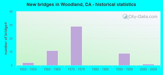
- New bridges - historical statistics
- 21950-1959
- 111960-1969
- 291970-1979
- 91990-1999
- 12000-2009


- Bridge Condition - Deck
- 90.0%Good
- 10.0%Fair

- Bridge Condition - Superstructure
- 70.0%Good
- 30.0%Fair

- Bridge Condition - Substructure
- 90.0%Good
- 10.0%Fair

- Bridge Condition - Channel
- 37.5%Very good
- 50.0%Good
- 12.5%Satisfactory
Find on map >> Show street view
Structure Number: 22 0025L, Location: 03-YOL-005-0.01 (Lat: 38.673158, Lng: -121.620228), Route carried "on" structure: Interstate 5, Year Built: 1969, Status: Open, Structure Length: 110.64m (362.99ft), Average Daily Traffic: 25,500 (year 2015), Truck Traffic: 20%, Average Future Daily Traffic: 43,255 (year 2041), Design Load: HS 20, Features Intersected: SACRAMENTO RIV (ELKHORN)
Minimum Vertical Clearance: 30+ m (98+ ft), Kilometerpoint: 0.010, Lanes on structure: 2, Lanes under structure: 6, Base Highway Network: Yes (, Subroute: 1), Owner: State Highway Agency, Approaching Roadway Width: 11.9m (39.0ft), Skew: 9 degrees, Navigation Control: Yes ( Vertical Clearance: 16.8m (55.1ft), Horizontal Clearance: 53.3m (174.9ft)), Material/Design: Steel continuous, Design/Construction: Stringer/Multi-beam, Number Of Spans In Main Unit: 17, Length of Maximum Span: 86.9m (285.1ft), Curb-To-Curb Width: 11.3m (37.1ft), Out-to-Out Width: 11.9m (39.0ft)
Condition: Deck: Good, Superstructure: Fair, Substructure: Fair, Channel: Good, Operating Rating: 84.9 metric tons, Method Used To Determine Operating Rating: Allowable Stress (AS), Inventory Rating: 36.9 metric tons, Method Used To Determine Inventory Rating: Allowable Stress (AS), Structural Evaluation: Somewhat better than minimum adequacy, Deck Geometry: Somewhat better than minimum adequacy, Underclear: Somewhat better than minimum adequacy, Waterway Adequacy: Equal to present desirable criteria, Approach Roadway Alignment: Equal to present desirable criteria, Designated Inspection Frequency: Every 24 months, Critical Feature Inspection Frequency: Every 24 months, Underwater Inspection Frequency: Every 60 months, Inspection Date: Febuary 2021, Critical Feature Inspection Date: May 2021, Underwater Inspection Date: July 2019, Deck Structure Type: Concrete Cast-file-Place, Wearing Surface/Protective System: Wearing Surface: Integral Concrete
Find on map >> Show street view
Structure Number: 22 0025R, Location: 03-YOL-005-0.01 (Lat: 38.673428, Lng: -121.620228), Route carried "on" structure: Interstate 5, Year Built: 1969, Status: Open, Structure Length: 110.64m (362.99ft), Average Daily Traffic: 25,500 (year 2015), Truck Traffic: 20%, Average Future Daily Traffic: 43,255 (year 2041), Design Load: HS 20, Features Intersected: SACRAMENTO RIV (ELKHORN)
Minimum Vertical Clearance: 30+ m (98+ ft), Kilometerpoint: 0.010, Lanes on structure: 2, Lanes under structure: 6, Base Highway Network: Yes (, Subroute: 1), Owner: State Highway Agency, Approaching Roadway Width: 11.9m (39.0ft), Skew: 9 degrees, Navigation Control: Yes ( Vertical Clearance: 16.8m (55.1ft), Horizontal Clearance: 53.3m (174.9ft)), Material/Design: Steel continuous, Design/Construction: Stringer/Multi-beam, Number Of Spans In Main Unit: 17, Length of Maximum Span: 86.9m (285.1ft), Curb-To-Curb Width: 11.3m (37.1ft), Out-to-Out Width: 11.9m (39.0ft)
Condition: Deck: Good, Superstructure: Fair, Substructure: Fair, Channel: Good, Operating Rating: 78.4 metric tons, Method Used To Determine Operating Rating: Allowable Stress (AS), Inventory Rating: 50.5 metric tons, Method Used To Determine Inventory Rating: Allowable Stress (AS), Structural Evaluation: Somewhat better than minimum adequacy, Deck Geometry: Somewhat better than minimum adequacy, Underclear: Somewhat better than minimum adequacy, Waterway Adequacy: Equal to present desirable criteria, Approach Roadway Alignment: Equal to present desirable criteria, Designated Inspection Frequency: Every 24 months, Critical Feature Inspection Frequency: Every 24 months, Underwater Inspection Frequency: Every 60 months, Inspection Date: Febuary 2021, Critical Feature Inspection Date: May 2021, Underwater Inspection Date: July 2019, Deck Structure Type: Concrete Cast-file-Place, Wearing Surface/Protective System: Wearing Surface: Integral Concrete
Find on map >> Show street view
Structure Number: 22 0038, Location: 03-YOL-113-13.10 (Lat: 38.720286, Lng: -121.764286), Route carried "on" structure: State highway 113, Year Built: 1960, Status: Open, Structure Length: 7.47m (24.51ft), Average Daily Traffic: 3,700 (year 2016), Truck Traffic: 7%, Average Future Daily Traffic: 5,200 (year 2040), Design Load: HS 20, Features Intersected: CACHE CREEK
Minimum Vertical Clearance: 30+ m (98+ ft), Kilometerpoint: 13.100, Lanes on structure: 2, Lanes under structure: 1, Base Highway Network: Yes (Inventory Route: 1, Subroute: 1), Owner: State Highway Agency, Approaching Roadway Width: 9.8m (32.2ft), Skew: 2 degrees, Material/Design: Prestressed concrete continuous, Design/Construction: Stringer/Multi-beam, Number Of Spans In Main Unit: 3, Length of Maximum Span: 24.8m (81.4ft), Curb or Sidewalk Widths: Left: 1.5m (4.9ft), Right: 1.5m (4.9ft), Curb-To-Curb Width: 9.8m (32.2ft), Out-to-Out Width: 14.0m (45.9ft)
Condition: Deck: Good, Superstructure: Good, Substructure: Good, Channel: Good, Operating Rating: 38.6 metric tons, Method Used To Determine Operating Rating: Load and Resistance Factor Rating (LRFR) rating reported by rating factor(RF) method using HL-93 loadings, Inventory Rating: 28.8 metric tons, Method Used To Determine Inventory Rating: Load and Resistance Factor Rating (LRFR) rating reported by rating factor(RF) method using HL-93 loadings, Structural Evaluation: Better than present minimum criteria, Deck Geometry: Meets minimum limits, Waterway Adequacy: Better than present minimum criteria, Approach Roadway Alignment: Equal to present desirable criteria, Designated Inspection Frequency: Every 24 months, Inspection Date: August 2020, Deck Structure Type: Concrete Cast-file-Place
Find on map >> Show street view
Structure Number: 22 0062L, Location: 03-YOL-113-R6.81 (Lat: 38.629400, Lng: -121.764964), Route carried "on" structure: State highway 113, Year Built: 1990, Status: Open, Structure Length: 7.41m (24.31ft), Average Daily Traffic: 10,750 (year 2016), Truck Traffic: 14%, Average Future Daily Traffic: 20,500 (year 2040), Design Load: HS 20+Mod, Features Intersected: CFNR
Minimum Vertical Clearance: 30+ m (98+ ft), Kilometerpoint: 6.810, Lanes on structure: 2, Base Highway Network: Yes (Inventory Route: 1, Subroute: 1), Owner: State Highway Agency, Approaching Roadway Width: 11.9m (39.0ft), Skew: 5 degrees, Material/Design: Prestressed concrete continuous, Design/Construction: Box Beam or Girders - Multiple, Number Of Spans In Main Unit: 3, Length of Maximum Span: 31.3m (102.7ft), Curb-To-Curb Width: 11.7m (38.4ft), Out-to-Out Width: 12.8m (42.0ft)
Condition: Deck: Good, Superstructure: Good, Substructure: Good, Operating Rating: 54.1 metric tons, Method Used To Determine Operating Rating: Assigned rating based on Load Factor Design (LFD) reported in metric tons, Inventory Rating: 32.4 metric tons, Method Used To Determine Inventory Rating: Assigned rating based on Load Factor Design (LFD) reported in metric tons, Structural Evaluation: Better than present minimum criteria, Deck Geometry: Better than present minimum criteria, Underclear: Better than present minimum criteria, Approach Roadway Alignment: Equal to present desirable criteria, Designated Inspection Frequency: Every 24 months, Inspection Date: August 2020, Deck Structure Type: Concrete Cast-file-Place
Find on map >> Show street view
Structure Number: 22 0062R, Location: 03-YOL-113-R6.81 (Lat: 38.628900, Lng: -121.764794), Route carried "on" structure: State highway 113, Year Built: 1990, Status: Open, Structure Length: 7.32m (24.02ft), Average Daily Traffic: 10,750 (year 2016), Truck Traffic: 14%, Average Future Daily Traffic: 20,500 (year 2040), Design Load: HS 20+Mod, Features Intersected: CFNR
Minimum Vertical Clearance: 30+ m (98+ ft), Kilometerpoint: 6.810, Lanes on structure: 2, Base Highway Network: Yes (Inventory Route: 1, Subroute: 1), Owner: State Highway Agency, Approaching Roadway Width: 11.9m (39.0ft), Skew: 5 degrees, Material/Design: Prestressed concrete continuous, Design/Construction: Box Beam or Girders - Multiple, Number Of Spans In Main Unit: 3, Length of Maximum Span: 32.1m (105.3ft), Curb-To-Curb Width: 11.7m (38.4ft), Out-to-Out Width: 12.8m (42.0ft)
Condition: Deck: Good, Superstructure: Good, Substructure: Good, Operating Rating: 54.1 metric tons, Method Used To Determine Operating Rating: Assigned rating based on Load Factor Design (LFD) reported in metric tons, Inventory Rating: 32.4 metric tons, Method Used To Determine Inventory Rating: Assigned rating based on Load Factor Design (LFD) reported in metric tons, Structural Evaluation: Better than present minimum criteria, Deck Geometry: Better than present minimum criteria, Underclear: Better than present minimum criteria, Approach Roadway Alignment: Equal to present desirable criteria, Designated Inspection Frequency: Every 24 months, Inspection Date: August 2020, Deck Structure Type: Concrete Cast-file-Place
Find on map >> Show street view
Structure Number: 22 0122, Location: 03-YOL-113-R6.11 (Lat: 38.619250, Lng: -121.767039), Route carried "on" structure: County highway , Year Built: 1990, Status: Open, Structure Length: 5.93m (19.46ft), Average Daily Traffic: 5,000 (year 2016), Truck Traffic: 15%, Average Future Daily Traffic: 7,600 (year 2040), Design Load: HS 20+Mod, Features Intersected: STATE ROUTE 113, Facility Carried by Structure: COUNTY ROAD 27
Minimum Vertical Clearance: 30+ m (98+ ft), Kilometerpoint: 0.000, Lanes on structure: 2, Lanes under structure: 4, Owner: State Highway Agency, Approaching Roadway Width: 12.2m (40.0ft), Material/Design: Prestressed concrete continuous, Design/Construction: Box Beam or Girders - Multiple, Number Of Spans In Main Unit: 2, Length of Maximum Span: 29.6m (97.1ft), Curb-To-Curb Width: 12.2m (40.0ft), Out-to-Out Width: 12.8m (42.0ft)
Condition: Deck: Fair, Superstructure: Good, Substructure: Good, Operating Rating: 54.1 metric tons, Method Used To Determine Operating Rating: Assigned rating based on Load Factor Design (LFD) reported in metric tons, Inventory Rating: 32.4 metric tons, Method Used To Determine Inventory Rating: Assigned rating based on Load Factor Design (LFD) reported in metric tons, Structural Evaluation: Better than present minimum criteria, Deck Geometry: Equal to present minimum criteria, Underclear: Somewhat better than minimum adequacy, Approach Roadway Alignment: Equal to present desirable criteria, Designated Inspection Frequency: Every 24 months, Inspection Date: August 2020, Deck Structure Type: Concrete Cast-file-Place
Find on map >> Show street view
Structure Number: 22 0124L, Location: 03-YOL-005-0.84 (Lat: 38.673272, Lng: -121.641897), Route carried "on" structure: Interstate 5, Year Built: 1969, Status: Open, Structure Length: 265.50m (871.06ft), Average Daily Traffic: 25,500 (year 2015), Truck Traffic: 20%, Average Future Daily Traffic: 43,000 (year 2040), Design Load: HS 20, Features Intersected: YOLO BYPASS
Minimum Vertical Clearance: 30+ m (98+ ft), Kilometerpoint: 0.840, Lanes on structure: 2, Base Highway Network: Yes (, Subroute: 1), Owner: State Highway Agency, Approaching Roadway Width: 11.9m (39.0ft), Material/Design: Prestressed concrete continuous, Design/Construction: Tee Beam, Number Of Spans In Main Unit: 4, Number Of Approach Spans: 208, Length of Maximum Span: 27.5m (90.2ft), Curb-To-Curb Width: 11.9m (39.0ft), Out-to-Out Width: 12.5m (41.0ft)
Condition: Deck: Good, Superstructure: Good, Substructure: Good, Channel: Very good, Operating Rating: 22.0 metric tons, Method Used To Determine Operating Rating: Load and Resistance Factor Rating (LRFR) rating reported by rating factor(RF) method using HL-93 loadings, Inventory Rating: 13.0 metric tons, Method Used To Determine Inventory Rating: Load and Resistance Factor Rating (LRFR) rating reported by rating factor(RF) method using HL-93 loadings, Structural Evaluation: High priority of corrective action, Deck Geometry: Equal to present minimum criteria, Waterway Adequacy: Equal to present desirable criteria, Approach Roadway Alignment: Equal to present desirable criteria, Designated Inspection Frequency: Every 24 months, Underwater Inspection Frequency: Every 60 months, Inspection Date: August 2021, Underwater Inspection Date: March 2020, Deck Structure Type: Concrete Cast-file-Place, Wearing Surface/Protective System: Wearing Surface: Bituminous
Find on map >> Show street view
Structure Number: 22 0124R, Location: 03-YOL-005-0.84 (Lat: 38.673536, Lng: -121.641894), Route carried "on" structure: Interstate 5, Year Built: 1969, Status: Open, Structure Length: 265.50m (871.06ft), Average Daily Traffic: 25,500 (year 2015), Truck Traffic: 20%, Average Future Daily Traffic: 43,000 (year 2040), Design Load: HS 20, Features Intersected: YOLO BYPASS
Minimum Vertical Clearance: 30+ m (98+ ft), Kilometerpoint: 0.840, Lanes on structure: 2, Base Highway Network: Yes (, Subroute: 1), Owner: State Highway Agency, Approaching Roadway Width: 11.9m (39.0ft), Material/Design: Prestressed concrete continuous, Design/Construction: Tee Beam, Number Of Spans In Main Unit: 4, Number Of Approach Spans: 208, Length of Maximum Span: 27.5m (90.2ft), Curb-To-Curb Width: 11.9m (39.0ft), Out-to-Out Width: 12.5m (41.0ft)
Condition: Deck: Good, Superstructure: Good, Substructure: Good, Channel: Very good, Operating Rating: 22.0 metric tons, Method Used To Determine Operating Rating: Load and Resistance Factor Rating (LRFR) rating reported by rating factor(RF) method using HL-93 loadings, Inventory Rating: 13.0 metric tons, Method Used To Determine Inventory Rating: Load and Resistance Factor Rating (LRFR) rating reported by rating factor(RF) method using HL-93 loadings, Structural Evaluation: High priority of corrective action, Deck Geometry: Equal to present minimum criteria, Waterway Adequacy: Equal to present desirable criteria, Approach Roadway Alignment: Equal to present desirable criteria, Designated Inspection Frequency: Every 24 months, Underwater Inspection Frequency: Every 60 months, Inspection Date: August 2021, Underwater Inspection Date: March 2020, Deck Structure Type: Concrete Cast-file-Place, Wearing Surface/Protective System: Wearing Surface: Bituminous
Find on map >> Show street view
Structure Number: 22 0127, Location: 03-YOL-113-R7.66 (Lat: 38.640992, Lng: -121.760342), Route carried "on" structure: County highway , Year Built: 1990, Status: Open, Structure Length: 6.28m (20.60ft), Average Daily Traffic: 1,500 (year 2016), Truck Traffic: 15%, Average Future Daily Traffic: 2,100 (year 2040), Design Load: HS 20+Mod, Features Intersected: STATE ROUTE 113, Facility Carried by Structure: COUNTY ROAD 25A
Minimum Vertical Clearance: 30+ m (98+ ft), Kilometerpoint: 0.000, Lanes on structure: 2, Lanes under structure: 4, Owner: State Highway Agency, Approaching Roadway Width: 12.2m (40.0ft), Skew: 1 degrees, Material/Design: Prestressed concrete continuous, Design/Construction: Box Beam or Girders - Multiple, Number Of Spans In Main Unit: 2, Length of Maximum Span: 31.4m (103.0ft), Curb-To-Curb Width: 12.2m (40.0ft), Out-to-Out Width: 13.3m (43.6ft)
Condition: Deck: Good, Superstructure: Good, Substructure: Good, Operating Rating: 54.1 metric tons, Method Used To Determine Operating Rating: Assigned rating based on Load Factor Design (LFD) reported in metric tons, Inventory Rating: 32.4 metric tons, Method Used To Determine Inventory Rating: Assigned rating based on Load Factor Design (LFD) reported in metric tons, Structural Evaluation: Better than present minimum criteria, Deck Geometry: Better than present minimum criteria, Underclear: Somewhat better than minimum adequacy, Approach Roadway Alignment: Equal to present desirable criteria, Designated Inspection Frequency: Every 24 months, Inspection Date: August 2020, Deck Structure Type: Concrete Cast-file-Place
Find on map >> Show street view
Structure Number: 22 0128, Location: 03-YOL-113-R9.22-WD (Lat: 38.662617, Lng: -121.751936), Route carried "on" structure: City street , Year Built: 1990, Status: Open, Structure Length: 6.52m (21.39ft), Average Daily Traffic: 10,000 (year 2016), Truck Traffic: 10%, Average Future Daily Traffic: 13,000 (year 2040), Design Load: HS 20+Mod, Features Intersected: STATE ROUTE 113, Facility Carried by Structure: EAST GIBSON ROAD
Minimum Vertical Clearance: 30+ m (98+ ft), Kilometerpoint: 0.000, Lanes on structure: 4, Lanes under structure: 6, Owner: State Highway Agency, Approaching Roadway Width: 19.5m (64.0ft), Material/Design: Prestressed concrete continuous, Design/Construction: Box Beam or Girders - Multiple, Number Of Spans In Main Unit: 2, Length of Maximum Span: 33.2m (108.9ft), Curb or Sidewalk Widths: Left: 1.5m (4.9ft), Right: 0.0m, Curb-To-Curb Width: 19.5m (64.0ft), Out-to-Out Width: 21.9m (71.9ft)
Condition: Deck: Good, Superstructure: Good, Substructure: Good, Operating Rating: 54.1 metric tons, Method Used To Determine Operating Rating: Assigned rating based on Load Factor Design (LFD) reported in metric tons, Inventory Rating: 32.4 metric tons, Method Used To Determine Inventory Rating: Assigned rating based on Load Factor Design (LFD) reported in metric tons, Structural Evaluation: Better than present minimum criteria, Deck Geometry: Better than present minimum criteria, Underclear: Better than present minimum criteria, Approach Roadway Alignment: Equal to present desirable criteria, Designated Inspection Frequency: Every 24 months, Inspection Date: August 2020, Deck Structure Type: Concrete Cast-file-Place
Find on map >> Show street view
Structure Number: 22 0130R, Location: 03-YOL-113-R10.22 (Lat: 38.677014, Lng: -121.750892), Route carried "on" structure: State highway 113, Year Built: 1973, Status: Open, Structure Length: 6.91m (22.67ft), Average Daily Traffic: 3,250 (year 2016), Truck Traffic: 10%, Average Future Daily Traffic: 6,100 (year 2040), Design Load: HS 20+Mod, Features Intersected: YOLO SHORTLINE RR, MAIN
Minimum Vertical Clearance: 30+ m (98+ ft), Kilometerpoint: 10.220, Lanes on structure: 2, Lanes under structure: 4, Base Highway Network: Yes (Inventory Route: 1, Subroute: 1), Owner: State Highway Agency, Approaching Roadway Width: 11.9m (39.0ft), Material/Design: Prestressed concrete continuous, Design/Construction: Box Beam or Girders - Multiple, Number Of Spans In Main Unit: 2, Length of Maximum Span: 41.0m (134.5ft), Curb-To-Curb Width: 11.9m (39.0ft), Out-to-Out Width: 12.5m (41.0ft)
Condition: Deck: Good, Superstructure: Good, Substructure: Good, Operating Rating: 68.4 metric tons, Method Used To Determine Operating Rating: Load and Resistance Factor Rating (LRFR) rating reported by rating factor(RF) method using HL-93 loadings, Inventory Rating: 47.0 metric tons, Method Used To Determine Inventory Rating: Load and Resistance Factor Rating (LRFR) rating reported by rating factor(RF) method using HL-93 loadings, Structural Evaluation: Better than present minimum criteria, Deck Geometry: Equal to present minimum criteria, Underclear: Equal to present minimum criteria, Approach Roadway Alignment: Equal to present desirable criteria, Designated Inspection Frequency: Every 24 months, Inspection Date: August 2020, Deck Structure Type: Concrete Cast-file-Place
Find on map >> Show street view
Structure Number: 22 0144, Location: 03-YOL-005-5.53 (Lat: 38.673558, Lng: -121.728508), Route carried "on" structure: County highway , Year Built: 1969, Year Reconstructed: 2011, Status: Open, Structure Length: 7.01m (23.00ft), Average Daily Traffic: 10,000 (year 2016), Truck Traffic: 10%, Average Future Daily Traffic: 13,000 (year 2040), Design Load: HS 20, Features Intersected: INTERSTATE 5, Facility Carried by Structure: COUNTY ROAD 102
Minimum Vertical Clearance: 30+ m (98+ ft), Kilometerpoint: 0.000, Lanes on structure: 4, Lanes under structure: 6, Base Highway Network: Yes, Owner: State Highway Agency, Approaching Roadway Width: 19.2m (63.0ft), Material/Design: Concrete continuous, Design/Construction: Box Beam or Girders - Multiple, Number Of Spans In Main Unit: 2, Length of Maximum Span: 35.0m (114.8ft), Curb or Sidewalk Widths: Left: 1.5m (4.9ft), Right: 0.0m, Curb-To-Curb Width: 19.2m (63.0ft), Out-to-Out Width: 21.5m (70.5ft)
Condition: Deck: Good, Superstructure: Fair, Substructure: Good, Operating Rating: 49.2 metric tons, Method Used To Determine Operating Rating: Load and Resistance Factor Rating (LRFR) rating reported by rating factor(RF) method using HL-93 loadings, Inventory Rating: 37.9 metric tons, Method Used To Determine Inventory Rating: Load and Resistance Factor Rating (LRFR) rating reported by rating factor(RF) method using HL-93 loadings, Structural Evaluation: Somewhat better than minimum adequacy, Deck Geometry: Equal to present minimum criteria, Underclear: High priority of corrective action, Approach Roadway Alignment: Equal to present desirable criteria, Designated Inspection Frequency: Every 24 months, Inspection Date: August 2020, Deck Structure Type: Concrete Cast-file-Place, Wearing Surface/Protective System: Wearing Surface: Integral Concrete
Find on map >> Show street view
Structure Number: 22 0146L, Location: 03-YOL-005-R6.51 (Lat: 38.676994, Lng: -121.745531), Route carried "on" structure: Interstate 5, Year Built: 1973, Status: Open, Structure Length: 8.81m (28.90ft), Average Daily Traffic: 22,000 (year 2016), Truck Traffic: 21%, Average Future Daily Traffic: 49,000 (year 2040), Design Load: HS 20, Features Intersected: YOLO SHORTLINE RR & MAIN
Minimum Vertical Clearance: 30+ m (98+ ft), Kilometerpoint: 6.510, Lanes on structure: 2, Lanes under structure: 6, Base Highway Network: Yes (, Subroute: 1), Owner: State Highway Agency, Approaching Roadway Width: 11.9m (39.0ft), Skew: 3 degrees, Material/Design: Prestressed concrete continuous, Design/Construction: Box Beam or Girders - Multiple, Number Of Spans In Main Unit: 2, Length of Maximum Span: 48.8m (160.1ft), Curb-To-Curb Width: 11.9m (39.0ft), Out-to-Out Width: 12.5m (41.0ft)
Condition: Deck: Good, Superstructure: Fair, Substructure: Fair, Operating Rating: 49.6 metric tons, Method Used To Determine Operating Rating: Load and Resistance Factor Rating (LRFR) rating reported by rating factor(RF) method using HL-93 loadings, Inventory Rating: 38.2 metric tons, Method Used To Determine Inventory Rating: Load and Resistance Factor Rating (LRFR) rating reported by rating factor(RF) method using HL-93 loadings, Structural Evaluation: Somewhat better than minimum adequacy, Deck Geometry: Equal to present minimum criteria, Underclear: Superior to present desirable criteria, Approach Roadway Alignment: Better than present minimum criteria, Designated Inspection Frequency: Every 24 months, Inspection Date: August 2020, Deck Structure Type: Concrete Cast-file-Place, Wearing Surface/Protective System: Wearing Surface: Integral Concrete
Find on map >> Show street view
Structure Number: 22 0146R, Location: 03-YOL-005-R6.50 (Lat: 38.676989, Lng: -121.745078), Route carried "on" structure: Interstate 5, Year Built: 1973, Status: Open, Structure Length: 8.93m (29.30ft), Average Daily Traffic: 22,000 (year 2016), Truck Traffic: 21%, Average Future Daily Traffic: 49,000 (year 2040), Design Load: HS 20, Features Intersected: YOLO SHORTLINE RR & MAIN
Minimum Vertical Clearance: 30+ m (98+ ft), Kilometerpoint: 6.500, Lanes on structure: 2, Lanes under structure: 6, Base Highway Network: Yes (, Subroute: 1), Owner: State Highway Agency, Approaching Roadway Width: 11.9m (39.0ft), Skew: 3 degrees, Material/Design: Prestressed concrete continuous, Design/Construction: Box Beam or Girders - Multiple, Number Of Spans In Main Unit: 2, Length of Maximum Span: 49.4m (162.1ft), Curb-To-Curb Width: 11.9m (39.0ft), Out-to-Out Width: 12.5m (41.0ft)
Condition: Deck: Good, Superstructure: Good, Substructure: Good, Operating Rating: 51.5 metric tons, Method Used To Determine Operating Rating: Load and Resistance Factor Rating (LRFR) rating reported by rating factor(RF) method using HL-93 loadings, Inventory Rating: 39.9 metric tons, Method Used To Determine Inventory Rating: Load and Resistance Factor Rating (LRFR) rating reported by rating factor(RF) method using HL-93 loadings, Structural Evaluation: Better than present minimum criteria, Deck Geometry: Equal to present minimum criteria, Underclear: Somewhat better than minimum adequacy, Approach Roadway Alignment: Better than present minimum criteria, Designated Inspection Frequency: Every 24 months, Inspection Date: August 2020, Deck Structure Type: Concrete Cast-file-Place, Wearing Surface/Protective System: Wearing Surface: Integral Concrete
Find on map >> Show street view
Structure Number: 22 0147R, Location: 03-YOL-113-R10.67-WD (Lat: 38.683611, Lng: -121.750744), Route carried "on" structure: State highway 113, Year Built: 1973, Status: Open, Structure Length: 12.76m (41.86ft), Average Daily Traffic: 3,250 (year 2016), Truck Traffic: 10%, Average Future Daily Traffic: 6,100 (year 2040), Design Load: HS 20+Mod, Features Intersected: INTERSTATE 5
Minimum Vertical Clearance: 30+ m (98+ ft), Kilometerpoint: 10.670, Lanes on structure: 2, Lanes under structure: 4, Base Highway Network: Yes (Inventory Route: 1, Subroute: 1), Owner: State Highway Agency, Approaching Roadway Width: 11.9m (39.0ft), Skew: 5 degrees, Material/Design: Prestressed concrete continuous, Design/Construction: Box Beam or Girders - Multiple, Number Of Spans In Main Unit: 2, Length of Maximum Span: 63.6m (208.7ft), Curb-To-Curb Width: 11.9m (39.0ft), Out-to-Out Width: 12.5m (41.0ft)
Condition: Deck: Good, Superstructure: Good, Substructure: Good, Operating Rating: 56.7 metric tons, Method Used To Determine Operating Rating: Load and Resistance Factor Rating (LRFR) rating reported by rating factor(RF) method using HL-93 loadings, Inventory Rating: 28.2 metric tons, Method Used To Determine Inventory Rating: Load and Resistance Factor Rating (LRFR) rating reported by rating factor(RF) method using HL-93 loadings, Structural Evaluation: Better than present minimum criteria, Deck Geometry: Equal to present minimum criteria, Underclear: High priority of corrective action, Approach Roadway Alignment: Equal to present desirable criteria, Designated Inspection Frequency: Every 24 months, Inspection Date: August 2020, Deck Structure Type: Concrete Cast-file-Place
Find on map >> Show street view
Structure Number: 22 0148, Location: 03-YOL-005-R7.70-WD (Lat: 38.691794, Lng: -121.757058), Route carried "on" structure: City street , Year Built: 1973, Status: Open, Structure Length: 11.70m (38.39ft), Average Daily Traffic: 5,000 (year 2016), Truck Traffic: 12%, Average Future Daily Traffic: 9,000 (year 2040), Design Load: HS 20, Features Intersected: INTERSTATE 5, Facility Carried by Structure: KENTUCKY AVE
Minimum Vertical Clearance: 30+ m (98+ ft), Kilometerpoint: 0.000, Lanes on structure: 2, Lanes under structure: 5, Owner: State Highway Agency, Approaching Roadway Width: 12.2m (40.0ft), Skew: 3 degrees, Material/Design: Prestressed concrete continuous, Design/Construction: Box Beam or Girders - Multiple, Number Of Spans In Main Unit: 3, Length of Maximum Span: 44.7m (146.7ft), Curb or Sidewalk Widths: Left: 0.0m, Right: 1.5m (4.9ft), Curb-To-Curb Width: 12.2m (40.0ft), Out-to-Out Width: 14.3m (46.9ft)
Condition: Deck: Good, Superstructure: Good, Substructure: Good, Operating Rating: 24.6 metric tons, Method Used To Determine Operating Rating: Load and Resistance Factor Rating (LRFR) rating reported by rating factor(RF) method using HL-93 loadings, Inventory Rating: 15.6 metric tons, Method Used To Determine Inventory Rating: Load and Resistance Factor Rating (LRFR) rating reported by rating factor(RF) method using HL-93 loadings, Structural Evaluation: Meets minimum limits, Deck Geometry: Equal to present minimum criteria, Underclear: Equal to present minimum criteria, Approach Roadway Alignment: Equal to present desirable criteria, Designated Inspection Frequency: Every 24 months, Inspection Date: August 2020, Deck Structure Type: Concrete Cast-file-Place, Wearing Surface/Protective System: Wearing Surface: Integral Concrete
Find on map >> Show street view
Structure Number: 22 015, Location: 03-YOL-005-R9.41 (Lat: 38.702656, Lng: -121.783828), Route carried "on" structure: County highway , Year Built: 1973, Status: Open, Structure Length: 9.30m (30.51ft), Average Daily Traffic: 5,000 (year 2016), Truck Traffic: 10%, Average Future Daily Traffic: 8,161 (year 2042), Design Load: HS 20, Features Intersected: INTERSTATE 5, Facility Carried by Structure: COUNTY ROAD 99S
Minimum Vertical Clearance: 30+ m (98+ ft), Kilometerpoint: 0.000, Lanes on structure: 2, Lanes under structure: 4, Owner: State Highway Agency, Approaching Roadway Width: 12.2m (40.0ft), Skew: 5 degrees, Material/Design: Prestressed concrete continuous, Design/Construction: Box Beam or Girders - Multiple, Number Of Spans In Main Unit: 2, Length of Maximum Span: 46.3m (151.9ft), Curb or Sidewalk Widths: Left: 0.0m, Right: 1.5m (4.9ft), Curb-To-Curb Width: 12.2m (40.0ft), Out-to-Out Width: 14.3m (46.9ft)
Condition: Deck: Good, Superstructure: Fair, Substructure: Good, Operating Rating: 23.7 metric tons, Method Used To Determine Operating Rating: Load and Resistance Factor Rating (LRFR) rating reported by rating factor(RF) method using HL-93 loadings, Inventory Rating: 15.9 metric tons, Method Used To Determine Inventory Rating: Load and Resistance Factor Rating (LRFR) rating reported by rating factor(RF) method using HL-93 loadings, Structural Evaluation: Meets minimum limits, Deck Geometry: Equal to present minimum criteria, Underclear: Somewhat better than minimum adequacy, Approach Roadway Alignment: Equal to present desirable criteria, Designated Inspection Frequency: Every 24 months, Inspection Date: Febuary 2022, Deck Structure Type: Concrete Cast-file-Place
Find on map >> Show street view
Structure Number: 22 0152L, Location: 03-YOL-005-R8.26-WD (Lat: 38.696419, Lng: -121.764944), Route carried "on" structure: Interstate 5, Year Built: 1973, Status: Open, Structure Length: 7.19m (23.59ft), Average Daily Traffic: 16,750 (year 2016), Average Future Daily Traffic: 21,000 (year 2040), Design Load: HS 20+Mod, Features Intersected: SR 113 & CFNR
Minimum Vertical Clearance: 30+ m (98+ ft), Kilometerpoint: 8.260, Lanes on structure: 2, Lanes under structure: 5, Base Highway Network: Yes (, Subroute: 1), Owner: State Highway Agency, Approaching Roadway Width: 11.9m (39.0ft), Skew: 1 degrees, Material/Design: Prestressed concrete continuous, Design/Construction: Box Beam or Girders - Multiple, Number Of Spans In Main Unit: 2, Length of Maximum Span: 37.5m (123.0ft), Curb-To-Curb Width: 11.9m (39.0ft), Out-to-Out Width: 12.5m (41.0ft)
Condition: Deck: Good, Superstructure: Good, Substructure: Good, Operating Rating: 60.3 metric tons, Method Used To Determine Operating Rating: Load and Resistance Factor Rating (LRFR) rating reported by rating factor(RF) method using HL-93 loadings, Inventory Rating: 37.9 metric tons, Method Used To Determine Inventory Rating: Load and Resistance Factor Rating (LRFR) rating reported by rating factor(RF) method using HL-93 loadings, Structural Evaluation: Better than present minimum criteria, Deck Geometry: Equal to present minimum criteria, Underclear: Meets minimum limits, Approach Roadway Alignment: Equal to present desirable criteria, Designated Inspection Frequency: Every 24 months, Inspection Date: August 2020, Deck Structure Type: Concrete Cast-file-Place, Wearing Surface/Protective System: Wearing Surface: Integral Concrete
Find on map >> Show street view
Structure Number: 22 0152R, Location: 03-YOL-005-R8.26-WD (Lat: 38.696719, Lng: -121.764947), Route carried "on" structure: Interstate 5, Year Built: 1973, Status: Open, Structure Length: 7.17m (23.52ft), Average Daily Traffic: 16,750 (year 2016), Average Future Daily Traffic: 21,000 (year 2040), Design Load: HS 20+Mod, Features Intersected: SR 113 & CFRN
Minimum Vertical Clearance: 30+ m (98+ ft), Kilometerpoint: 8.260, Lanes on structure: 2, Lanes under structure: 4, Base Highway Network: Yes (, Subroute: 1), Owner: State Highway Agency, Approaching Roadway Width: 11.9m (39.0ft), Skew: 1 degrees, Material/Design: Prestressed concrete continuous, Design/Construction: Box Beam or Girders - Multiple, Number Of Spans In Main Unit: 2, Length of Maximum Span: 37.5m (123.0ft), Curb-To-Curb Width: 11.9m (39.0ft), Out-to-Out Width: 12.5m (41.0ft)
Condition: Deck: Good, Superstructure: Good, Substructure: Good, Operating Rating: 67.7 metric tons, Method Used To Determine Operating Rating: Load and Resistance Factor Rating (LRFR) rating reported by rating factor(RF) method using HL-93 loadings, Inventory Rating: 45.0 metric tons, Method Used To Determine Inventory Rating: Load and Resistance Factor Rating (LRFR) rating reported by rating factor(RF) method using HL-93 loadings, Structural Evaluation: Better than present minimum criteria, Deck Geometry: Equal to present minimum criteria, Underclear: Meets minimum limits, Approach Roadway Alignment: Equal to present desirable criteria, Designated Inspection Frequency: Every 24 months, Inspection Date: August 2020, Deck Structure Type: Concrete Cast-file-Place, Wearing Surface/Protective System: Wearing Surface: Integral Concrete
Find on map >> Show street view
Structure Number: 22 0154L, Location: 03-YOL-005-R8.87 (Lat: 38.698742, Lng: -121.775850), Route carried "on" structure: Interstate 5, Year Built: 1970, Status: Open, Structure Length: 6.80m (22.31ft), Average Daily Traffic: 11,750 (year 2014), Average Future Daily Traffic: 27,892 (year 2042), Design Load: HS 20, Features Intersected: CFNR
Minimum Vertical Clearance: 30+ m (98+ ft), Kilometerpoint: 8.870, Lanes on structure: 2, Base Highway Network: Yes (, Subroute: 1), Owner: State Highway Agency, Approaching Roadway Width: 11.9m (39.0ft), Skew: 5 degrees, Material/Design: Concrete continuous, Design/Construction: Box Beam or Girders - Multiple, Number Of Spans In Main Unit: 3, Length of Maximum Span: 27.0m (88.6ft), Curb-To-Curb Width: 11.9m (39.0ft), Out-to-Out Width: 12.5m (41.0ft)
Condition: Deck: Good, Superstructure: Fair, Substructure: Good, Operating Rating: 50.9 metric tons, Method Used To Determine Operating Rating: Load and Resistance Factor Rating (LRFR) rating reported by rating factor(RF) method using HL-93 loadings, Inventory Rating: 36.9 metric tons, Method Used To Determine Inventory Rating: Load and Resistance Factor Rating (LRFR) rating reported by rating factor(RF) method using HL-93 loadings, Structural Evaluation: Somewhat better than minimum adequacy, Deck Geometry: Equal to present minimum criteria, Underclear: Better than present minimum criteria, Approach Roadway Alignment: Equal to present desirable criteria, Designated Inspection Frequency: Every 24 months, Inspection Date: Febuary 2022, Deck Structure Type: Concrete Cast-file-Place, Wearing Surface/Protective System: Wearing Surface: Integral Concrete
Find on map >> Show street view
Structure Number: 22 0154R, Location: 03-YOL-005-R8.89 (Lat: 38.699103, Lng: -121.776242), Route carried "on" structure: Interstate 5, Year Built: 1973, Status: Open, Structure Length: 6.80m (22.31ft), Average Daily Traffic: 11,750 (year 2014), Average Future Daily Traffic: 27,892 (year 2042), Design Load: HS 20+Mod, Features Intersected: CFNR
Minimum Vertical Clearance: 30+ m (98+ ft), Kilometerpoint: 8.890, Lanes on structure: 2, Base Highway Network: Yes (, Subroute: 1), Owner: State Highway Agency, Approaching Roadway Width: 11.9m (39.0ft), Skew: 5 degrees, Material/Design: Concrete continuous, Design/Construction: Box Beam or Girders - Multiple, Number Of Spans In Main Unit: 3, Length of Maximum Span: 27.0m (88.6ft), Curb-To-Curb Width: 11.9m (39.0ft), Out-to-Out Width: 12.5m (41.0ft)
Condition: Deck: Good, Superstructure: Fair, Substructure: Good, Operating Rating: 50.9 metric tons, Method Used To Determine Operating Rating: Load and Resistance Factor Rating (LRFR) rating reported by rating factor(RF) method using HL-93 loadings, Inventory Rating: 36.9 metric tons, Method Used To Determine Inventory Rating: Load and Resistance Factor Rating (LRFR) rating reported by rating factor(RF) method using HL-93 loadings, Structural Evaluation: Somewhat better than minimum adequacy, Deck Geometry: Equal to present minimum criteria, Underclear: Better than present minimum criteria, Approach Roadway Alignment: Equal to present minimum criteria, Designated Inspection Frequency: Every 24 months, Inspection Date: Febuary 2022, Deck Structure Type: Concrete Cast-file-Place, Wearing Surface/Protective System: Wearing Surface: Integral Concrete
Find on map >> Show street view
Structure Number: 22 0158, Location: 03-YOL-005-4.49 (Lat: 38.673433, Lng: -121.709364), Route carried "on" structure: County highway , Year Built: 1969, Status: Open, Structure Length: 6.03m (19.78ft), Average Daily Traffic: 100 (year 2016), Truck Traffic: 10%, Average Future Daily Traffic: 220 (year 2040), Design Load: HS 20, Features Intersected: INTERSTATE 5, Facility Carried by Structure: WYE LINE
Minimum Vertical Clearance: 30+ m (98+ ft), Kilometerpoint: 0.000, Lanes on structure: 2, Lanes under structure: 4, Owner: State Highway Agency, Approaching Roadway Width: 6.1m (20.0ft), Material/Design: Concrete continuous, Design/Construction: Box Beam or Girders - Multiple, Number Of Spans In Main Unit: 2, Length of Maximum Span: 29.9m (98.1ft), Curb-To-Curb Width: 6.1m (20.0ft), Out-to-Out Width: 6.7m (22.0ft)
Condition: Deck: Fair, Superstructure: Fair, Substructure: Good, Operating Rating: 57.3 metric tons, Method Used To Determine Operating Rating: Load and Resistance Factor Rating (LRFR) rating reported by rating factor(RF) method using HL-93 loadings, Inventory Rating: 44.4 metric tons, Method Used To Determine Inventory Rating: Load and Resistance Factor Rating (LRFR) rating reported by rating factor(RF) method using HL-93 loadings, Structural Evaluation: Somewhat better than minimum adequacy, Deck Geometry: Somewhat better than minimum adequacy, Underclear: Somewhat better than minimum adequacy, Approach Roadway Alignment: Better than present minimum criteria, Designated Inspection Frequency: Every 24 months, Inspection Date: August 2020, Deck Structure Type: Concrete Cast-file-Place
Find on map >> Show street view
Structure Number: 22 0169L, Location: 03-YOL-005-R6.63 (Lat: 38.678478, Lng: -121.746725), Route carried "on" structure: Interstate 5, Year Built: 1973, Status: Open, Structure Length: 7.62m (25.00ft), Average Daily Traffic: 22,000 (year 2016), Truck Traffic: 21%, Average Future Daily Traffic: 49,000 (year 2040), Design Load: HS 20, Features Intersected: PIONEER AVE
Minimum Vertical Clearance: 30+ m (98+ ft), Kilometerpoint: 6.630, Lanes on structure: 2, Lanes under structure: 2, Base Highway Network: Yes (, Subroute: 1), Owner: State Highway Agency, Approaching Roadway Width: 11.9m (39.0ft), Skew: 5 degrees, Material/Design: Prestressed concrete continuous, Design/Construction: Box Beam or Girders - Multiple, Number Of Spans In Main Unit: 3, Length of Maximum Span: 40.2m (131.9ft), Curb-To-Curb Width: 11.9m (39.0ft), Out-to-Out Width: 12.5m (41.0ft)
Condition: Deck: Good, Superstructure: Good, Substructure: Good, Operating Rating: 24.0 metric tons, Method Used To Determine Operating Rating: Load and Resistance Factor Rating (LRFR) rating reported by rating factor(RF) method using HL-93 loadings, Inventory Rating: 14.9 metric tons, Method Used To Determine Inventory Rating: Load and Resistance Factor Rating (LRFR) rating reported by rating factor(RF) method using HL-93 loadings, Structural Evaluation: High priority of corrective action, Deck Geometry: Equal to present minimum criteria, Underclear: Meets minimum limits, Approach Roadway Alignment: Better than present minimum criteria, Designated Inspection Frequency: Every 24 months, Inspection Date: August 2020, Deck Structure Type: Concrete Cast-file-Place, Wearing Surface/Protective System: Wearing Surface: Integral Concrete
Find on map >> Show street view
Structure Number: 22 0169R, Location: 03-YOL-005-R6.65 (Lat: 38.679036, Lng: -121.746733), Route carried "on" structure: Interstate 5, Year Built: 1973, Status: Open, Structure Length: 7.13m (23.39ft), Average Daily Traffic: 22,000 (year 2016), Truck Traffic: 21%, Average Future Daily Traffic: 49,000 (year 2040), Design Load: HS 20, Features Intersected: PIONEER AVE
Minimum Vertical Clearance: 30+ m (98+ ft), Kilometerpoint: 6.650, Lanes on structure: 2, Lanes under structure: 2, Base Highway Network: Yes (, Subroute: 1), Owner: State Highway Agency, Approaching Roadway Width: 11.9m (39.0ft), Skew: 5 degrees, Material/Design: Prestressed concrete continuous, Design/Construction: Box Beam or Girders - Multiple, Number Of Spans In Main Unit: 3, Length of Maximum Span: 40.2m (131.9ft), Curb-To-Curb Width: 11.9m (39.0ft), Out-to-Out Width: 12.5m (41.0ft)
Condition: Deck: Good, Superstructure: Good, Substructure: Good, Operating Rating: 24.0 metric tons, Method Used To Determine Operating Rating: Load and Resistance Factor Rating (LRFR) rating reported by rating factor(RF) method using HL-93 loadings, Inventory Rating: 14.9 metric tons, Method Used To Determine Inventory Rating: Load and Resistance Factor Rating (LRFR) rating reported by rating factor(RF) method using HL-93 loadings, Structural Evaluation: High priority of corrective action, Deck Geometry: Equal to present minimum criteria, Underclear: Meets minimum limits, Approach Roadway Alignment: Better than present minimum criteria, Designated Inspection Frequency: Every 24 months, Inspection Date: August 2020, Deck Structure Type: Concrete Cast-file-Place, Wearing Surface/Protective System: Wearing Surface: Integral Concrete
Find on map >> Show street view
Structure Number: 22 0173L, Location: 03-YOL-005-R7.10-WD (Lat: 38.684411, Lng: -121.751072), Route carried "on" structure: Interstate 5, Year Built: 1973, Status: Open, Structure Length: 3.73m (12.24ft), Average Daily Traffic: 22,000 (year 2016), Truck Traffic: 21%, Average Future Daily Traffic: 48,600 (year 2040), Design Load: HS 20, Features Intersected: EAST BEAMER STREET
Minimum Vertical Clearance: 30+ m (98+ ft), Kilometerpoint: 7.100, Lanes on structure: 2, Lanes under structure: 2, Base Highway Network: Yes (, Subroute: 1), Owner: State Highway Agency, Approaching Roadway Width: 11.9m (39.0ft), Skew: 3 degrees, Material/Design: Prestressed concrete, Design/Construction: Box Beam or Girders - Multiple, Number Of Spans In Main Unit: 1, Length of Maximum Span: 36.7m (120.4ft), Curb-To-Curb Width: 11.9m (39.0ft), Out-to-Out Width: 12.5m (41.0ft)
Condition: Deck: Good, Superstructure: Good, Substructure: Good, Operating Rating: 51.2 metric tons, Method Used To Determine Operating Rating: Load and Resistance Factor Rating (LRFR) rating reported by rating factor(RF) method using HL-93 loadings, Inventory Rating: 33.0 metric tons, Method Used To Determine Inventory Rating: Load and Resistance Factor Rating (LRFR) rating reported by rating factor(RF) method using HL-93 loadings, Structural Evaluation: Better than present minimum criteria, Deck Geometry: Equal to present minimum criteria, Underclear: Superior to present desirable criteria, Approach Roadway Alignment: Equal to present desirable criteria, Designated Inspection Frequency: Every 24 months, Inspection Date: August 2020, Deck Structure Type: Concrete Cast-file-Place, Wearing Surface/Protective System: Wearing Surface: Integral Concrete
Find on map >> Show street view
Structure Number: 22 0173R, Location: 03-YOL-005-R7.10-WD (Lat: 38.684408, Lng: -121.750669), Route carried "on" structure: Interstate 5, Year Built: 1973, Status: Open, Structure Length: 3.73m (12.24ft), Average Daily Traffic: 22,000 (year 2016), Truck Traffic: 21%, Average Future Daily Traffic: 48,600 (year 2040), Design Load: HS 20, Features Intersected: EAST BEAMER STREET
Minimum Vertical Clearance: 30+ m (98+ ft), Kilometerpoint: 7.100, Lanes on structure: 2, Lanes under structure: 2, Base Highway Network: Yes (, Subroute: 1), Owner: State Highway Agency, Approaching Roadway Width: 11.9m (39.0ft), Skew: 3 degrees, Material/Design: Prestressed concrete, Design/Construction: Box Beam or Girders - Multiple, Number Of Spans In Main Unit: 1, Length of Maximum Span: 36.7m (120.4ft), Curb-To-Curb Width: 11.9m (39.0ft), Out-to-Out Width: 12.5m (41.0ft)
Condition: Deck: Good, Superstructure: Good, Substructure: Good, Operating Rating: 51.2 metric tons, Method Used To Determine Operating Rating: Load and Resistance Factor Rating (LRFR) rating reported by rating factor(RF) method using HL-93 loadings, Inventory Rating: 33.0 metric tons, Method Used To Determine Inventory Rating: Load and Resistance Factor Rating (LRFR) rating reported by rating factor(RF) method using HL-93 loadings, Structural Evaluation: Better than present minimum criteria, Deck Geometry: Equal to present minimum criteria, Underclear: Equal to present minimum criteria, Approach Roadway Alignment: Equal to present desirable criteria, Designated Inspection Frequency: Every 24 months, Inspection Date: August 2020, Deck Structure Type: Concrete Cast-file-Place, Wearing Surface/Protective System: Wearing Surface: Integral Concrete
Find on map >> Show street view
Structure Number: 22 0174F, Location: 03-YOL-005-R7.11-WD (Lat: 38.684417, Lng: -121.751458), Route carried "on" structure: Ramp Interstate 5, Year Built: 1973, Status: Open, Structure Length: 3.41m (11.19ft), Average Daily Traffic: 10,000 (year 2016), Truck Traffic: 28%, Average Future Daily Traffic: 16,000 (year 2040), Design Load: HS 20, Features Intersected: EAST BEAMER STREET
Minimum Vertical Clearance: 30+ m (98+ ft), Kilometerpoint: 7.110, Lanes on structure: 2, Lanes under structure: 2, Base Highway Network: Yes (, Subroute: 1), Owner: State Highway Agency, Approaching Roadway Width: 11.9m (39.0ft), Skew: 3 degrees, Material/Design: Prestressed concrete, Design/Construction: Box Beam or Girders - Multiple, Number Of Spans In Main Unit: 1, Length of Maximum Span: 33.6m (110.2ft), Curb-To-Curb Width: 11.9m (39.0ft), Out-to-Out Width: 12.5m (41.0ft)
Condition: Deck: Good, Superstructure: Good, Substructure: Good, Operating Rating: 46.3 metric tons, Method Used To Determine Operating Rating: Load and Resistance Factor Rating (LRFR) rating reported by rating factor(RF) method using HL-93 loadings, Inventory Rating: 32.4 metric tons, Method Used To Determine Inventory Rating: Load and Resistance Factor Rating (LRFR) rating reported by rating factor(RF) method using HL-93 loadings, Structural Evaluation: Better than present minimum criteria, Deck Geometry: Superior to present desirable criteria, Underclear: Meets minimum limits, Approach Roadway Alignment: Equal to present desirable criteria, Designated Inspection Frequency: Every 24 months, Inspection Date: August 2020, Deck Structure Type: Concrete Cast-file-Place, Wearing Surface/Protective System: Wearing Surface: Integral Concrete
Find on map >> Show street view
Structure Number: 22C0019, Location: 3.5 MI N OF I-5 (Lat: 38.726133, Lng: -121.729883), Route carried "on" structure: County highway , Year Built: 1955, Status: Open, Structure Length: 10.79m (35.40ft), Average Daily Traffic: 6,200 (year 2004), Truck Traffic: 15%, Average Future Daily Traffic: 10,056 (year 2043), Design Load: H 20, Features Intersected: CACHE CREEK, Facility Carried by Structure: COUNTY ROAD 102
Minimum Vertical Clearance: 30+ m (98+ ft), Kilometerpoint: 0.000, Lanes on structure: 2, Base Highway Network: Yes, Owner: County Highway Agency, Approaching Roadway Width: 8.5m (27.9ft), Skew: 2 degrees, Material/Design: Concrete continuous, Design/Construction: Tee Beam, Number Of Spans In Main Unit: 7, Length of Maximum Span: 16.5m (54.1ft), Curb or Sidewalk Widths: Left: 0.5m (1.6ft), Right: 0.5m (1.6ft), Curb-To-Curb Width: 8.6m (28.2ft), Out-to-Out Width: 9.8m (32.2ft)
Condition: Deck: Fair, Superstructure: Fair, Substructure: Good, Channel: Satisfactory, Operating Rating: 31.4 metric tons, Method Used To Determine Operating Rating: Load and Resistance Factor Rating (LRFR) rating reported by rating factor(RF) method using HL-93 loadings, Inventory Rating: 22.4 metric tons, Method Used To Determine Inventory Rating: Load and Resistance Factor Rating (LRFR) rating reported by rating factor(RF) method using HL-93 loadings, Structural Evaluation: Somewhat better than minimum adequacy, Deck Geometry: Meets minimum limits, Waterway Adequacy: Equal to present desirable criteria, Approach Roadway Alignment: Equal to present desirable criteria, Designated Inspection Frequency: Every 24 months, Inspection Date: October 2021, Deck Structure Type: Concrete Cast-file-Place, Wearing Surface/Protective System: Wearing Surface: Bituminous
Find on map >> Show street view
Structure Number: 22C0027, Location: 1.3 MI N OF CO ROAD #29 (Lat: 38.610381, Lng: -121.802892), Route carried "on" structure: County highway , Year Built: 1959, Year Reconstructed: 2013, Status: Open, Structure Length: 2.59m (8.50ft), Average Daily Traffic: 6,160 (year 2009), Truck Traffic: 10%, Average Future Daily Traffic: 7,651 (year 2037), Design Load: HS 20, Features Intersected: WILLOW SLOUGH, Facility Carried by Structure: COUNTY ROAD 98
Minimum Vertical Clearance: 30+ m (98+ ft), Kilometerpoint: 0.000, Lanes on structure: 2, Base Highway Network: Yes, Owner: County Highway Agency, Approaching Roadway Width: 13.5m (44.3ft), Material/Design: Concrete continuous, Design/Construction: Slab, Number Of Spans In Main Unit: 3, Length of Maximum Span: 9.1m (29.9ft), Curb-To-Curb Width: 12.9m (42.3ft), Out-to-Out Width: 13.6m (44.6ft)
Condition: Deck: Good, Superstructure: Good, Substructure: Good, Channel: Good, Operating Rating: 60.9 metric tons, Method Used To Determine Operating Rating: Load Factor (LF), Inventory Rating: 36.6 metric tons, Method Used To Determine Inventory Rating: Load Factor (LF), Structural Evaluation: Better than present minimum criteria, Deck Geometry: Somewhat better than minimum adequacy, Waterway Adequacy: Equal to present minimum criteria, Approach Roadway Alignment: Equal to present desirable criteria, Designated Inspection Frequency: Every 48 months, Inspection Date: November 2019, Deck Structure Type: Concrete Cast-file-Place
Find on map >> Show street view
Structure Number: 22C0053, Location: JUST WEST OF I-5 ON-RAMP (Lat: 38.676642, Lng: -121.644522), Route carried "on" structure: County highway , Year Built: 2003, Status: Open, Structure Length: 7.64m (25.07ft), Average Daily Traffic: 2,500 (year 2014), Truck Traffic: 4%, Average Future Daily Traffic: 6,268 (year 2044), Design Load: HS 20+Mod, Features Intersected: TULE CANAL, Facility Carried by Structure: COUNTY ROAD 22
Minimum Vertical Clearance: 30+ m (98+ ft), Kilometerpoint: 0.000, Lanes on structure: 2, Owner: County Highway Agency, Approaching Roadway Width: 10.0m (32.8ft), Skew: 1 degrees, Material/Design: Concrete continuous, Design/Construction: Box Beam or Girders - Multiple, Number Of Spans In Main Unit: 3, Length of Maximum Span: 29.0m (95.1ft), Curb-To-Curb Width: 10.8m (35.4ft), Out-to-Out Width: 11.3m (37.1ft)
Condition: Deck: Good, Superstructure: Good, Substructure: Good, Channel: Very good, Operating Rating: 54.1 metric tons, Method Used To Determine Operating Rating: Assigned rating based on Load Factor Design (LFD) reported in metric tons, Inventory Rating: 32.4 metric tons, Method Used To Determine Inventory Rating: Assigned rating based on Load Factor Design (LFD) reported in metric tons, Structural Evaluation: Better than present minimum criteria, Deck Geometry: Somewhat better than minimum adequacy, Waterway Adequacy: Meets minimum limits, Approach Roadway Alignment: Equal to present desirable criteria, Designated Inspection Frequency: Every 48 months, Underwater Inspection Frequency: Every 60 months, Inspection Date: January 2022, Underwater Inspection Date: March 2020, Deck Structure Type: Concrete Cast-file-Place
Find on map >> Show street view
Structure Number: 22 0025L, Location: 03-YOL-005-0.01 (Lat: 38.673158, Lng: -121.620228), Route carried "under" structure: County highway , Year Built: 1969, Structure Length: 0. m, Average Daily Traffic: 500 (year 2015), Truck Traffic: 10%, Features Intersected: SACRAMENTO RIV (ELKHORN), Facility Carried by Structure: INTERSTATE 5 SB
Minimum Vertical Clearance: 17.65m (57.91ft), Kilometerpoint: 0.000, Lanes on structure: 2, Lanes under structure: 4, Material/Design: Steel continuous, Design/Construction: Stringer/Multi-beam, Length of Maximum Span: 86.9m (285.1ft)
Find on map >> Show street view
Structure Number: 22 0025R, Location: 03-YOL-005-0.01 (Lat: 38.673428, Lng: -121.620228), Route carried "under" structure: County highway , Year Built: 1969, Structure Length: 0. m, Average Daily Traffic: 500 (year 2015), Truck Traffic: 10%, Features Intersected: SACRAMENTO RIV (ELKHORN), Facility Carried by Structure: INTERSTATE 5 NB
Minimum Vertical Clearance: 16.15m (52.99ft), Kilometerpoint: 0.000, Lanes on structure: 2, Lanes under structure: 4, Material/Design: Steel continuous, Design/Construction: Stringer/Multi-beam, Length of Maximum Span: 86.9m (285.1ft)
Find on map >> Show street view
Structure Number: 22 0122, Location: 03-YOL-113-R6.11 (Lat: 38.619250, Lng: -121.767039), Route carried "under" structure: State highway 113, Year Built: 1990, Structure Length: 0. m, Average Daily Traffic: 23,700 (year 2016), Truck Traffic: 13%, Features Intersected: STATE ROUTE 113, Facility Carried by Structure: COUNTY ROAD 27
Minimum Vertical Clearance: 5.11m (16.77ft), Kilometerpoint: 6.110, Lanes on structure: 2, Lanes under structure: 4, Material/Design: Prestressed concrete continuous, Design/Construction: Box Beam or Girders - Multiple, Length of Maximum Span: 29.6m (97.1ft)
Find on map >> Show street view
Structure Number: 22 0127, Location: 03-YOL-113-R7.66 (Lat: 38.640992, Lng: -121.760342), Route carried "under" structure: State highway 113, Year Built: 1990, Structure Length: 0. m, Average Daily Traffic: 21,500 (year 2016), Truck Traffic: 14%, Features Intersected: STATE ROUTE 113, Facility Carried by Structure: COUNTY ROAD 25A
Minimum Vertical Clearance: 5.08m (16.67ft), Kilometerpoint: 7.660, Lanes on structure: 2, Lanes under structure: 4, Material/Design: Prestressed concrete continuous, Design/Construction: Box Beam or Girders - Multiple, Length of Maximum Span: 31.4m (103.0ft)
Find on map >> Show street view
Structure Number: 22 0128, Location: 03-YOL-113-R9.22-WD (Lat: 38.662617, Lng: -121.751936), Route carried "under" structure: State highway 113, Year Built: 1990, Structure Length: 0. m, Average Daily Traffic: 15,300 (year 2016), Truck Traffic: 13%, Features Intersected: STATE ROUTE 113, Facility Carried by Structure: EAST GIBSON ROAD
Minimum Vertical Clearance: 5.16m (16.93ft), Kilometerpoint: 9.220, Lanes on structure: 4, Lanes under structure: 6, Material/Design: Prestressed concrete continuous, Design/Construction: Box Beam or Girders - Multiple, Length of Maximum Span: 33.2m (108.9ft)
Find on map >> Show street view
Structure Number: 22 0130L, Location: 03-YOL-113-R10.22 (Lat: 38.677014, Lng: -121.751169), Route carried "under" structure: City street , Year Built: 1973, Structure Length: 0. m, Average Daily Traffic: 15,000 (year 2016), Truck Traffic: 5%, Features Intersected: YOLO SHORTLINE RR, MAIN, Facility Carried by Structure: STATE ROUTE 113 SB
Minimum Vertical Clearance: 7.57m (24.84ft), Kilometerpoint: 0.000, Lanes on structure: 2, Lanes under structure: 4, Material/Design: Prestressed concrete continuous, Design/Construction: Box Beam or Girders - Multiple, Length of Maximum Span: 41.0m (134.5ft)
Find on map >> Show street view
Structure Number: 22 0130R, Location: 03-YOL-113-R10.22 (Lat: 38.677014, Lng: -121.750892), Route carried "under" structure: City street , Year Built: 1973, Structure Length: 0. m, Average Daily Traffic: 15,000 (year 2016), Truck Traffic: 5%, Features Intersected: YOLO SHORTLINE RR, MAIN, Facility Carried by Structure: STATE ROUTE 113 NB
Minimum Vertical Clearance: 7.57m (24.84ft), Kilometerpoint: 0.000, Lanes on structure: 2, Lanes under structure: 4, Material/Design: Prestressed concrete continuous, Design/Construction: Box Beam or Girders - Multiple, Length of Maximum Span: 41.0m (134.5ft)
Find on map >> Show street view
Structure Number: 22 0144, Location: 03-YOL-005-5.53 (Lat: 38.673558, Lng: -121.728508), Route carried "under" structure: Interstate 5, Year Built: 1969, Structure Length: 0. m, Average Daily Traffic: 44,000 (year 2014), Truck Traffic: 21%, Features Intersected: INTERSTATE 5, Facility Carried by Structure: COUNTY ROAD 102
Minimum Vertical Clearance: 4.97m (16.31ft), Kilometerpoint: 5.530, Lanes on structure: 4, Lanes under structure: 6, Material/Design: Concrete continuous, Design/Construction: Box Beam or Girders - Multiple, Length of Maximum Span: 35.0m (114.8ft)
Find on map >> Show street view
Structure Number: 22 0146L, Location: 03-YOL-005-R6.51 (Lat: 38.676994, Lng: -121.745531), Route carried "under" structure: City street , Year Built: 1973, Structure Length: 0. m, Average Daily Traffic: 10,000 (year 2016), Truck Traffic: 10%, Features Intersected: YOLO SHORTLINE RR & MAIN, Facility Carried by Structure: INTERSTATE 5 SB
Minimum Vertical Clearance: 7.34m (24.08ft), Kilometerpoint: 0.000, Lanes on structure: 2, Lanes under structure: 6, Material/Design: Prestressed concrete continuous, Design/Construction: Box Beam or Girders - Multiple, Length of Maximum Span: 48.8m (160.1ft)
Find on map >> Show street view
Structure Number: 22 0146R, Location: 03-YOL-005-R6.50 (Lat: 38.676989, Lng: -121.745078), Route carried "under" structure: City street , Year Built: 1973, Structure Length: 0. m, Average Daily Traffic: 10,000 (year 2016), Truck Traffic: 10%, Features Intersected: YOLO SHORTLINE RR & MAIN, Facility Carried by Structure: INTERSTATE 5 NB
Minimum Vertical Clearance: 6.63m (21.75ft), Kilometerpoint: 0.000, Lanes on structure: 2, Lanes under structure: 6, Material/Design: Prestressed concrete continuous, Design/Construction: Box Beam or Girders - Multiple, Length of Maximum Span: 49.4m (162.1ft)
Find on map >> Show street view
Structure Number: 22 0147R, Location: 03-YOL-113-R10.67-WD (Lat: 38.683611, Lng: -121.750744), Route carried "under" structure: Interstate 5, Year Built: 1973, Structure Length: 0. m, Average Daily Traffic: 44,000 (year 2016), Truck Traffic: 21%, Features Intersected: INTERSTATE 5, Facility Carried by Structure: STATE ROUTE 113 NB
Minimum Vertical Clearance: 5.00m (16.40ft), Kilometerpoint: 7.090, Lanes on structure: 2, Lanes under structure: 4, Material/Design: Prestressed concrete continuous, Design/Construction: Box Beam or Girders - Multiple, Length of Maximum Span: 63.6m (208.7ft)
Find on map >> Show street view
Structure Number: 22 0148, Location: 03-YOL-005-R7.70-WD (Lat: 38.691794, Lng: -121.757058), Route carried "under" structure: Interstate 5, Year Built: 1973, Structure Length: 0. m, Average Daily Traffic: 33,500 (year 2016), Truck Traffic: 21%, Features Intersected: INTERSTATE 5, Facility Carried by Structure: KENTUCKY AVE
Minimum Vertical Clearance: 5.31m (17.42ft), Kilometerpoint: 7.700, Lanes on structure: 2, Lanes under structure: 5, Material/Design: Prestressed concrete continuous, Design/Construction: Box Beam or Girders - Multiple, Length of Maximum Span: 44.7m (146.7ft)
Find on map >> Show street view
Structure Number: 22 015, Location: 03-YOL-005-R9.41 (Lat: 38.702656, Lng: -121.783828), Route carried "under" structure: Interstate 5, Year Built: 1973, Structure Length: 0. m, Average Daily Traffic: 23,500 (year 2016), Truck Traffic: 25%, Features Intersected: INTERSTATE 5, Facility Carried by Structure: COUNTY ROAD 99S
Minimum Vertical Clearance: 4.90m (16.08ft), Kilometerpoint: 9.410, Lanes on structure: 2, Lanes under structure: 4, Material/Design: Prestressed concrete continuous, Design/Construction: Box Beam or Girders - Multiple, Length of Maximum Span: 46.3m (151.9ft)
Find on map >> Show street view
Structure Number: 22 0152L, Location: 03-YOL-005-R8.26-WD (Lat: 38.696419, Lng: -121.764944), Route carried "under" structure: State highway 113, Year Built: 1973, Structure Length: 0. m, Average Daily Traffic: 6,600 (year 2016), Truck Traffic: 10%, Features Intersected: SR 113 & CFNR, Facility Carried by Structure: INTERSTATE 5 SB
Minimum Vertical Clearance: 7.06m (23.16ft), Kilometerpoint: 11.430, Lanes on structure: 2, Lanes under structure: 5, Material/Design: Prestressed concrete continuous, Design/Construction: Box Beam or Girders - Multiple, Length of Maximum Span: 37.5m (123.0ft)
Find on map >> Show street view
Structure Number: 22 0152R, Location: 03-YOL-005-R8.26-WD (Lat: 38.696719, Lng: -121.764947), Route carried "under" structure: State highway 113, Year Built: 1973, Structure Length: 0. m, Average Daily Traffic: 6,600 (year 2016), Truck Traffic: 10%, Features Intersected: SR 113 & CFRN, Facility Carried by Structure: INTERSTATE 5 NB
Minimum Vertical Clearance: 7.34m (24.08ft), Kilometerpoint: 11.450, Lanes on structure: 2, Lanes under structure: 4, Material/Design: Prestressed concrete continuous, Design/Construction: Box Beam or Girders - Multiple, Length of Maximum Span: 37.5m (123.0ft)
Find on map >> Show street view
Structure Number: 22 0158, Location: 03-YOL-005-4.49 (Lat: 38.673433, Lng: -121.709364), Route carried "under" structure: Interstate 5, Year Built: 1969, Structure Length: 0. m, Average Daily Traffic: 51,000 (year 2016), Truck Traffic: 20%, Features Intersected: INTERSTATE 5, Facility Carried by Structure: WYE LINE
Minimum Vertical Clearance: 4.85m (15.91ft), Kilometerpoint: 4.490, Lanes on structure: 2, Lanes under structure: 4, Material/Design: Concrete continuous, Design/Construction: Box Beam or Girders - Multiple, Length of Maximum Span: 29.9m (98.1ft)
Find on map >> Show street view
Structure Number: 22 0169L, Location: 03-YOL-005-R6.63 (Lat: 38.678478, Lng: -121.746725), Route carried "under" structure: County highway , Year Built: 1973, Structure Length: 0. m, Average Daily Traffic: 5,000 (year 2016), Truck Traffic: 10%, Features Intersected: PIONEER AVE, Facility Carried by Structure: INTERSTATE 5 SB
Minimum Vertical Clearance: 5.87m (19.26ft), Kilometerpoint: 0.000, Lanes on structure: 2, Lanes under structure: 2, Material/Design: Prestressed concrete continuous, Design/Construction: Box Beam or Girders - Multiple, Length of Maximum Span: 40.2m (131.9ft)
Find on map >> Show street view
Structure Number: 22 0169R, Location: 03-YOL-005-R6.65 (Lat: 38.679036, Lng: -121.746733), Route carried "under" structure: County highway , Year Built: 1973, Structure Length: 0. m, Average Daily Traffic: 5,000 (year 2016), Truck Traffic: 10%, Features Intersected: PIONEER AVE, Facility Carried by Structure: INTERSTATE 5 NB
Minimum Vertical Clearance: 4.72m (15.49ft), Kilometerpoint: 0.000, Lanes on structure: 2, Lanes under structure: 2, Material/Design: Prestressed concrete continuous, Design/Construction: Box Beam or Girders - Multiple, Length of Maximum Span: 40.2m (131.9ft)
Find on map >> Show street view
Structure Number: 22 0173L, Location: 03-YOL-005-R7.10-WD (Lat: 38.684411, Lng: -121.751072), Route carried "under" structure: City street , Year Built: 1973, Structure Length: 0. m, Average Daily Traffic: 5,000 (year 2016), Truck Traffic: 2%, Features Intersected: EAST BEAMER STREET, Facility Carried by Structure: INTERSTATE 5 SB
Minimum Vertical Clearance: 5.16m (16.93ft), Kilometerpoint: 0.000, Lanes on structure: 2, Lanes under structure: 2, Material/Design: Prestressed concrete, Design/Construction: Box Beam or Girders - Multiple, Length of Maximum Span: 36.7m (120.4ft)
Find on map >> Show street view
Structure Number: 22 0173R, Location: 03-YOL-005-R7.10-WD (Lat: 38.684408, Lng: -121.750669), Route carried "under" structure: City street , Year Built: 1973, Structure Length: 0. m, Average Daily Traffic: 5,000 (year 2016), Truck Traffic: 2%, Features Intersected: EAST BEAMER STREET, Facility Carried by Structure: INTERSTATE 5 NB
Minimum Vertical Clearance: 4.62m (15.16ft), Kilometerpoint: 0.000, Lanes on structure: 2, Lanes under structure: 2, Material/Design: Prestressed concrete, Design/Construction: Box Beam or Girders - Multiple, Length of Maximum Span: 36.7m (120.4ft)
Find on map >> Show street view
Structure Number: 22 0174F, Location: 03-YOL-005-R7.11-WD (Lat: 38.684417, Lng: -121.751458), Route carried "under" structure: City street , Year Built: 1973, Structure Length: 0. m, Average Daily Traffic: 5,000 (year 2016), Truck Traffic: 2%, Features Intersected: EAST BEAMER STREET, Facility Carried by Structure: S5-S113 CONNECTOR
Minimum Vertical Clearance: 4.55m (14.93ft), Kilometerpoint: 0.000, Lanes on structure: 2, Lanes under structure: 2, Material/Design: Prestressed concrete, Design/Construction: Box Beam or Girders - Multiple, Length of Maximum Span: 33.6m (110.2ft)