Bridge Statistics for West Sacramento, California (CA)
Condition, Traffic, Stress, Structural Evaluation, Project Costs
- National Bridge Inventory (NBI) Statistics
- 69Number of bridges
- 3,363ft / 1,025mTotal length
- $7,771,000Total costs
- 1,794,142Total average daily traffic
- 190,687Total average daily truck traffic
- National Bridge Inventory (NBI) Registered Bridges for West Sacramento
- No street view available for this location
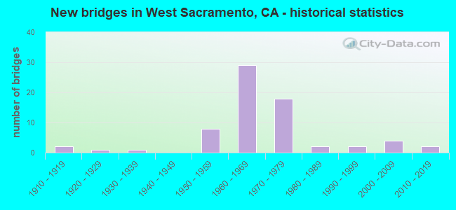
- New bridges - historical statistics
- 21910-1919
- 11920-1929
- 11930-1939
- 81950-1959
- 291960-1969
- 181970-1979
- 21980-1989
- 21990-1999
- 42000-2009
- 22010-2019

- Reconstructed bridges - Historical Statistics
- 21960-1969
- 11970-1979
- 11980-1989
- 01990-1999
- 22000-2009
- 12010-2019


- Bridge Condition - Deck
- 65.9%Good
- 4.9%Satisfactory
- 17.1%Fair
- 12.2%Poor

- Bridge Condition - Superstructure
- 77.5%Good
- 5.0%Satisfactory
- 12.5%Fair
- 5.0%Poor

- Bridge Condition - Substructure
- 82.9%Good
- 4.9%Satisfactory
- 12.2%Fair

- Bridge Condition - Channel
- 15.8%Excellent
- 52.6%Very good
- 21.1%Good
- 5.3%Satisfactory
- 5.3%Fair
Find on map >> Show street view
Structure Number: 22 0021, Location: 03-YOL-275-13.07-WSAC (Lat: 38.580839, Lng: -121.509708), Route carried "on" structure: State highway 275, Year Built: 1934, Year Reconstructed: 2005, Status: Open, Structure Length: 22.49m (73.79ft), Average Daily Traffic: 12,000 (year 2013), Truck Traffic: 4%, Average Future Daily Traffic: 23,770 (year 2041), Features Intersected: SACRAMENTO RIVER (TOWER), Facility Carried by Structure: WEST CAPITOL AVE
Minimum Vertical Clearance: 4.62m (15.16ft), Kilometerpoint: 13.070, Lanes on structure: 4, Base Highway Network: Yes, Owner: State Highway Agency, Approaching Roadway Width: 22.6m (74.1ft), Navigation Control: Yes ( Vertical Clearance: 30.5m (100.1ft), Horizontal Clearance: 52.4m (171.9ft)), Material/Design: Steel, Design/Construction: Movable - Lift, Number Of Spans In Main Unit: 1, Number Of Approach Spans: 7, Length of Maximum Span: 63.9m (209.6ft), Curb or Sidewalk Widths: Left: 2.7m (8.9ft), Right: 2.7m (8.9ft), Curb-To-Curb Width: 15.2m (49.9ft), Out-to-Out Width: 15.8m (51.8ft)
Condition: Deck: Good, Superstructure: Good, Substructure: Good, Channel: Very good, Operating Rating: 43.1 metric tons, Method Used To Determine Operating Rating: Load Factor (LF), Inventory Rating: 25.9 metric tons, Method Used To Determine Inventory Rating: Load Factor (LF), Structural Evaluation: Equal to present minimum criteria, Deck Geometry: High priority of corrective action, Waterway Adequacy: Equal to present desirable criteria, Approach Roadway Alignment: Equal to present desirable criteria, Designated Inspection Frequency: Every 24 months, Critical Feature Inspection Frequency: Every 24 months, Underwater Inspection Frequency: Every 60 months, Inspection Date: June 2021, Critical Feature Inspection Date: December 2020, Underwater Inspection Date: July 2019, Deck Structure Type: Concrete Cast-file-Place, Wearing Surface/Protective System: Wearing Surface: Integral Concrete
Find on map >> Show street view
Structure Number: 22 0026L, Location: 03-YOL-080-R11.31-WSAC (Lat: 38.593117, Lng: -121.551517), Route carried "on" structure: Interstate 80, Year Built: 1971, Status: Open, Structure Length: 123.44m (404.99ft), Average Daily Traffic: 43,000 (year 2015), Truck Traffic: 10%, Average Future Daily Traffic: 71,922 (year 2041), Design Load: HS 20, Features Intersected: SACRAMENTO RIVER (BRYTE)
Minimum Vertical Clearance: 30+ m (98+ ft), Kilometerpoint: 11.310, Lanes on structure: 3, Lanes under structure: 6, Base Highway Network: Yes (, Subroute: 2), Owner: State Highway Agency, Approaching Roadway Width: 15.5m (50.9ft), Navigation Control: Yes ( Vertical Clearance: 16.7m (54.8ft), Horizontal Clearance: 107.1m (351.4ft)), Material/Design: Steel continuous, Design/Construction: Box Beam or Girders - Multiple, Number Of Spans In Main Unit: 22, Length of Maximum Span: 112.8m (370.1ft), Curb-To-Curb Width: 14.9m (48.9ft), Out-to-Out Width: 15.5m (50.9ft)
Condition: Deck: Fair, Superstructure: Good, Substructure: Fair, Channel: Good, Operating Rating: 28.5 metric tons, Method Used To Determine Operating Rating: Load and Resistance Factor Rating (LRFR) rating reported by rating factor(RF) method using HL-93 loadings, Inventory Rating: 22.0 metric tons, Method Used To Determine Inventory Rating: Load and Resistance Factor Rating (LRFR) rating reported by rating factor(RF) method using HL-93 loadings, Structural Evaluation: Somewhat better than minimum adequacy, Deck Geometry: Meets minimum limits, Underclear: Equal to present minimum criteria, Waterway Adequacy: Equal to present desirable criteria, Approach Roadway Alignment: Equal to present desirable criteria, Designated Inspection Frequency: Every 24 months, Critical Feature Inspection Frequency: Every 24 months, Underwater Inspection Frequency: Every 60 months, Inspection Date: Febuary 2021, Critical Feature Inspection Date: December 2020, Underwater Inspection Date: July 2019, Deck Structure Type: Concrete Cast-file-Place, Wearing Surface/Protective System: Wearing Surface: Integral Concrete
Find on map >> Show street view
Structure Number: 22 0026R, Location: 03-YOL-080-R11.31-WSAC (Lat: 38.592981, Lng: -121.551181), Route carried "on" structure: Interstate 80, Year Built: 1971, Status: Open, Structure Length: 123.44m (404.99ft), Average Daily Traffic: 43,000 (year 2015), Truck Traffic: 10%, Average Future Daily Traffic: 71,922 (year 2041), Design Load: HS 20, Features Intersected: SACRAMENTO RIVER (BRYTE)
Minimum Vertical Clearance: 30+ m (98+ ft), Kilometerpoint: 11.310, Lanes on structure: 3, Lanes under structure: 6, Base Highway Network: Yes (, Subroute: 2), Owner: State Highway Agency, Approaching Roadway Width: 15.5m (50.9ft), Navigation Control: Yes ( Vertical Clearance: 16.7m (54.8ft), Horizontal Clearance: 107.1m (351.4ft)), Material/Design: Steel continuous, Design/Construction: Box Beam or Girders - Multiple, Number Of Spans In Main Unit: 22, Length of Maximum Span: 112.8m (370.1ft), Curb-To-Curb Width: 14.9m (48.9ft), Out-to-Out Width: 15.5m (50.9ft)
Condition: Deck: Fair, Superstructure: Good, Substructure: Fair, Channel: Good, Operating Rating: 28.5 metric tons, Method Used To Determine Operating Rating: Load and Resistance Factor Rating (LRFR) rating reported by rating factor(RF) method using HL-93 loadings, Inventory Rating: 22.0 metric tons, Method Used To Determine Inventory Rating: Load and Resistance Factor Rating (LRFR) rating reported by rating factor(RF) method using HL-93 loadings, Structural Evaluation: Somewhat better than minimum adequacy, Deck Geometry: Meets minimum limits, Underclear: Equal to present minimum criteria, Waterway Adequacy: Equal to present desirable criteria, Approach Roadway Alignment: Equal to present desirable criteria, Designated Inspection Frequency: Every 24 months, Critical Feature Inspection Frequency: Every 24 months, Underwater Inspection Frequency: Every 60 months, Inspection Date: Febuary 2021, Critical Feature Inspection Date: December 2020, Underwater Inspection Date: July 2019, Deck Structure Type: Concrete Cast-file-Place, Wearing Surface/Protective System: Wearing Surface: Integral Concrete
Find on map >> Show street view
Structure Number: 22 0045, Location: 03-YOL-080-7.25 (Lat: 38.567969, Lng: -121.612325), Route carried "on" structure: Interstate 80, Year Built: 1963, Year Reconstructed: 1986, Status: Open, Structure Length: 268.22m (879.99ft), Average Daily Traffic: 135,000 (year 2015), Truck Traffic: 9%, Average Future Daily Traffic: 212,000 (year 2040), Design Load: HS 20, Features Intersected: YOLO CAUSEWAY EAST
Minimum Vertical Clearance: 30+ m (98+ ft), Kilometerpoint: 7.250, Lanes on structure: 6, Base Highway Network: Yes (, Subroute: 2), Owner: State Highway Agency, Approaching Roadway Width: 35.7m (117.1ft), Skew: 30 degrees, Material/Design: Prestressed concrete, Design/Construction: Tee Beam, Number Of Spans In Main Unit: 220, Length of Maximum Span: 12.2m (40.0ft), Curb or Sidewalk Widths: Left: 3.7m (12.1ft), Right: 0.0m, Curb-To-Curb Width: 35.1m (115.2ft), Out-to-Out Width: 40.7m (133.5ft)
Condition: Deck: Good, Superstructure: Good, Substructure: Good, Channel: Good, Operating Rating: 59.3 metric tons, Method Used To Determine Operating Rating: Load Factor (LF), Inventory Rating: 34.3 metric tons, Method Used To Determine Inventory Rating: Load Factor (LF), Structural Evaluation: Better than present minimum criteria, Deck Geometry: Superior to present desirable criteria, Waterway Adequacy: Equal to present desirable criteria, Approach Roadway Alignment: Equal to present desirable criteria, Designated Inspection Frequency: Every 24 months, Inspection Date: August 2021, Deck Structure Type: Concrete Cast-file-Place
Find on map >> Show street view
Structure Number: 22 01, Location: 03-YOL-080-9.18 (Lat: 38.573983, Lng: -121.577747), Route carried "on" structure: Interstate 80, Year Built: 1951, Year Reconstructed: 1969, Status: Open, Structure Length: 3.44m (11.29ft), Average Daily Traffic: 145,000 (year 2015), Truck Traffic: 9%, Average Future Daily Traffic: 217,000 (year 2040), Design Load: HS 20, Features Intersected: ENTERPRISE BLVD
Minimum Vertical Clearance: 30+ m (98+ ft), Kilometerpoint: 9.180, Lanes on structure: 10, Lanes under structure: 4, Base Highway Network: Yes (, Subroute: 2), Owner: State Highway Agency, Approaching Roadway Width: 53.3m (174.9ft), Skew: 33 degrees, Material/Design: Concrete continuous, Design/Construction: Slab, Number Of Spans In Main Unit: 3, Length of Maximum Span: 13.4m (44.0ft), Curb-To-Curb Width: 55.4m (181.8ft), Out-to-Out Width: 56.7m (186.0ft)
Condition: Deck: Good, Superstructure: Good, Substructure: Good, Operating Rating: 71.3 metric tons, Method Used To Determine Operating Rating: Load Factor (LF), Inventory Rating: 42.8 metric tons, Method Used To Determine Inventory Rating: Load Factor (LF), Structural Evaluation: Better than present minimum criteria, Deck Geometry: Superior to present desirable criteria, Approach Roadway Alignment: Equal to present desirable criteria, Designated Inspection Frequency: Every 24 months, Inspection Date: May 2021, Deck Structure Type: Concrete Cast-file-Place, Wearing Surface/Protective System: Wearing Surface: Integral Concrete
Find on map >> Show street view
Structure Number: 22 0101L, Location: 03-YOL-505-11.68 (Lat: 38.694756, Lng: -121.954406), Route carried "on" structure: Interstate 505, Year Built: 1977, Status: Open, Structure Length: 18.24m (59.84ft), Average Daily Traffic: 11,000 (year 2010), Truck Traffic: 27%, Average Future Daily Traffic: 14,358 (year 2041), Design Load: HS 20, Features Intersected: CACHE CREEK
Minimum Vertical Clearance: 30+ m (98+ ft), Kilometerpoint: 11.680, Lanes on structure: 2, Base Highway Network: Yes (Inventory Route: 5, Subroute: 1), Owner: State Highway Agency, Approaching Roadway Width: 11.7m (38.4ft), Skew: 4 degrees, Material/Design: Concrete continuous, Design/Construction: Box Beam or Girders - Multiple, Number Of Spans In Main Unit: 7, Length of Maximum Span: 27.4m (89.9ft), Curb-To-Curb Width: 11.7m (38.4ft), Out-to-Out Width: 12.8m (42.0ft)
Condition: Deck: Satisfactory, Superstructure: Satisfactory, Substructure: Satisfactory, Channel: Fair, Operating Rating: 70.0 metric tons, Method Used To Determine Operating Rating: Load and Resistance Factor Rating (LRFR) rating reported by rating factor(RF) method using HL-93 loadings, Inventory Rating: 48.0 metric tons, Method Used To Determine Inventory Rating: Load and Resistance Factor Rating (LRFR) rating reported by rating factor(RF) method using HL-93 loadings, Structural Evaluation: Equal to present minimum criteria, Deck Geometry: Equal to present minimum criteria, Waterway Adequacy: Equal to present desirable criteria, Approach Roadway Alignment: Equal to present desirable criteria, Designated Inspection Frequency: Every 24 months, Inspection Date: May 2021, Deck Structure Type: Concrete Cast-file-Place, Wearing Surface/Protective System: Wearing Surface: Integral Concrete
Find on map >> Show street view
Structure Number: 22 0102, Location: 03-YOL-050-2.18-WSAC (Lat: 38.575842, Lng: -121.530822), Route carried "on" structure: Interstate 50, Year Built: 1951, Year Reconstructed: 1966, Status: Open, Structure Length: 3.20m (10.50ft), Average Daily Traffic: 90,000 (year 2015), Truck Traffic: 11%, Average Future Daily Traffic: 149,000 (year 2040), Design Load: HS 20, Features Intersected: WESTACRE RD
Minimum Vertical Clearance: 30+ m (98+ ft), Kilometerpoint: 2.180, Lanes on structure: 7, Lanes under structure: 2, Base Highway Network: Yes (, Subroute: 1), Owner: State Highway Agency, Approaching Roadway Width: 45.7m (149.9ft), Skew: 31 degrees, Material/Design: Concrete continuous, Design/Construction: Slab, Number Of Spans In Main Unit: 3, Length of Maximum Span: 12.2m (40.0ft), Curb-To-Curb Width: 45.3m (148.6ft), Out-to-Out Width: 46.5m (152.6ft)
Condition: Deck: Poor, Superstructure: Poor, Substructure: Good, Operating Rating: 66.4 metric tons, Method Used To Determine Operating Rating: Load Factor (LF), Inventory Rating: 40.2 metric tons, Method Used To Determine Inventory Rating: Load Factor (LF), Structural Evaluation: Meets minimum limits, Deck Geometry: Superior to present desirable criteria, Underclear: Meets minimum limits, Approach Roadway Alignment: Equal to present desirable criteria, Length Of Structure Improvement: 3.20m (10.50ft), Designated Inspection Frequency: Every 24 months, Inspection Date: May 2021, Bridge Improvement Cost: $1,536,000, Roadway Improvement Cost: $307,000, Total Project Cost: $2,580,000 ( Estimate for 2020), Deck Structure Type: Concrete Cast-file-Place, Wearing Surface/Protective System: Wearing Surface: Integral Concrete
Find on map >> Show street view
Structure Number: 22 0102S, Location: 03-YOL-050-2.17-WSAC (Lat: 38.575697, Lng: -121.530817), Route carried "on" structure: Ramp State highway 50, Year Built: 1966, Status: Open, Structure Length: 3.14m (10.30ft), Average Daily Traffic: 5,000 (year 2010), Truck Traffic: 4%, Average Future Daily Traffic: 10,168 (year 2040), Design Load: HS 20, Features Intersected: WESTACRE RD
Minimum Vertical Clearance: 30+ m (98+ ft), Kilometerpoint: 2.170, Lanes on structure: 2, Lanes under structure: 2, Base Highway Network: Yes, Owner: State Highway Agency, Approaching Roadway Width: 11.3m (37.1ft), Skew: 1 degrees, Material/Design: Concrete continuous, Design/Construction: Slab, Number Of Spans In Main Unit: 3, Length of Maximum Span: 11.9m (39.0ft), Curb-To-Curb Width: 11.3m (37.1ft), Out-to-Out Width: 11.9m (39.0ft)
Condition: Deck: Satisfactory, Superstructure: Satisfactory, Substructure: Good, Operating Rating: 72.6 metric tons, Method Used To Determine Operating Rating: Load Factor (LF), Inventory Rating: 43.7 metric tons, Method Used To Determine Inventory Rating: Load Factor (LF), Structural Evaluation: Equal to present minimum criteria, Deck Geometry: Superior to present desirable criteria, Underclear: Meets minimum limits, Approach Roadway Alignment: Equal to present desirable criteria, Designated Inspection Frequency: Every 48 months, Inspection Date: May 2021, Deck Structure Type: Concrete Cast-file-Place
Find on map >> Show street view
Structure Number: 22 0103K, Location: 03-YOL-050-2.47-WSAC (Lat: 38.577794, Lng: -121.525519), Route carried "on" structure: Ramp State highway 50, Year Built: 1951, Status: Open, Structure Length: 2.41m (7.91ft), Average Daily Traffic: 5,000 (year 2015), Truck Traffic: 4%, Average Future Daily Traffic: 10,000 (year 2040), Design Load: HS 20, Features Intersected: JEFFERSON BLVD (OLD 84)
Minimum Vertical Clearance: 30+ m (98+ ft), Kilometerpoint: 2.470, Lanes on structure: 2, Lanes under structure: 4, Base Highway Network: Yes, Owner: State Highway Agency, Approaching Roadway Width: 11.3m (37.1ft), Material/Design: Concrete continuous, Design/Construction: Slab, Number Of Spans In Main Unit: 2, Length of Maximum Span: 11.6m (38.1ft), Curb or Sidewalk Widths: Left: 0.6m (2.0ft), Right: 0.6m (2.0ft), Curb-To-Curb Width: 8.7m (28.5ft), Out-to-Out Width: 10.5m (34.4ft)
Condition: Deck: Poor, Superstructure: Poor, Substructure: Fair, Operating Rating: 44.1 metric tons, Method Used To Determine Operating Rating: Load and Resistance Factor Rating (LRFR) rating reported by rating factor(RF) method using HL-93 loadings, Inventory Rating: 34.0 metric tons, Method Used To Determine Inventory Rating: Load and Resistance Factor Rating (LRFR) rating reported by rating factor(RF) method using HL-93 loadings, Structural Evaluation: Meets minimum limits, Deck Geometry: Meets minimum limits, Underclear: High priority of corrective action, Approach Roadway Alignment: Equal to present desirable criteria, Length Of Structure Improvement: 2.41m (7.91ft), Designated Inspection Frequency: Every 24 months, Inspection Date: May 2021, Bridge Improvement Cost: $243,000, Roadway Improvement Cost: $48,000, Total Project Cost: $406,000 ( Estimate for 2017), Deck Structure Type: Concrete Cast-file-Place
Find on map >> Show street view
Structure Number: 22 0106L, Location: 03-YOL-050-2.48-WSAC (Lat: 38.577189, Lng: -121.525525), Route carried "on" structure: Interstate 50, Year Built: 1966, Status: Open, Structure Length: 13.99m (45.90ft), Average Daily Traffic: 43,000 (year 2015), Truck Traffic: 11%, Average Future Daily Traffic: 74,500 (year 2040), Design Load: HS 20+Mod, Features Intersected: JEFFERSON BLVD (OLD 84)
Minimum Vertical Clearance: 30+ m (98+ ft), Kilometerpoint: 2.480, Lanes on structure: 3, Lanes under structure: 6, Base Highway Network: Yes (, Subroute: 1), Owner: State Highway Agency, Approaching Roadway Width: 15.5m (50.9ft), Skew: 9 degrees, Material/Design: Steel, Design/Construction: Stringer/Multi-beam, Number Of Spans In Main Unit: 3, Number Of Approach Spans: 1, Length of Maximum Span: 43.0m (141.1ft), Curb-To-Curb Width: 15.5m (50.9ft), Out-to-Out Width: 16.2m (53.1ft)
Condition: Deck: Good, Superstructure: Good, Substructure: Good, Operating Rating: 67.1 metric tons, Method Used To Determine Operating Rating: Load Factor (LF), Inventory Rating: 40.2 metric tons, Method Used To Determine Inventory Rating: Load Factor (LF), Structural Evaluation: Better than present minimum criteria, Deck Geometry: Somewhat better than minimum adequacy, Underclear: Equal to present minimum criteria, Approach Roadway Alignment: Equal to present desirable criteria, Designated Inspection Frequency: Every 24 months, Other Special Inspection Frequency: Every 48 months, Inspection Date: May 2021, Other Special Inspection Date: July 2018, Deck Structure Type: Concrete Cast-file-Place, Wearing Surface/Protective System: Wearing Surface: Integral Concrete
Find on map >> Show street view
Structure Number: 22 0106R, Location: 03-YOL-050-2.48-WSAC (Lat: 38.576972, Lng: -121.525469), Route carried "on" structure: Interstate 50, Year Built: 1966, Status: Open, Structure Length: 12.92m (42.39ft), Average Daily Traffic: 43,000 (year 2015), Truck Traffic: 11%, Average Future Daily Traffic: 74,500 (year 2040), Design Load: HS 20+Mod, Features Intersected: JEFFERSON BLVD (OLD 84)
Minimum Vertical Clearance: 30+ m (98+ ft), Kilometerpoint: 2.480, Lanes on structure: 3, Lanes under structure: 6, Base Highway Network: Yes (, Subroute: 1), Owner: State Highway Agency, Approaching Roadway Width: 15.5m (50.9ft), Skew: 9 degrees, Material/Design: Steel, Design/Construction: Stringer/Multi-beam, Number Of Spans In Main Unit: 3, Number Of Approach Spans: 1, Length of Maximum Span: 42.7m (140.1ft), Curb-To-Curb Width: 15.5m (50.9ft), Out-to-Out Width: 16.2m (53.1ft)
Condition: Deck: Good, Superstructure: Good, Substructure: Good, Operating Rating: 64.8 metric tons, Method Used To Determine Operating Rating: Load Factor (LF), Inventory Rating: 38.9 metric tons, Method Used To Determine Inventory Rating: Load Factor (LF), Structural Evaluation: Better than present minimum criteria, Deck Geometry: Somewhat better than minimum adequacy, Underclear: Meets minimum limits, Approach Roadway Alignment: Equal to present desirable criteria, Designated Inspection Frequency: Every 24 months, Other Special Inspection Frequency: Every 48 months, Inspection Date: May 2021, Other Special Inspection Date: July 2018, Deck Structure Type: Concrete Cast-file-Place, Wearing Surface/Protective System: Wearing Surface: Integral Concrete
Find on map >> Show street view
Structure Number: 22 0108, Location: 03-YOL-050-1.20-WSAC (Lat: 38.575403, Lng: -121.548867), Route carried "on" structure: County highway , Year Built: 1969, Year Reconstructed: 2010, Status: Open, Structure Length: 8.55m (28.05ft), Average Daily Traffic: 15,000 (year 2015), Truck Traffic: 25%, Average Future Daily Traffic: 22,000 (year 2040), Design Load: HS 20, Features Intersected: U.S. HIGHWAY 50, Facility Carried by Structure: HARBOR BLVD
Minimum Vertical Clearance: 30+ m (98+ ft), Kilometerpoint: 0.000, Lanes on structure: 7, Lanes under structure: 10, Base Highway Network: Yes, Owner: State Highway Agency, Approaching Roadway Width: 34.8m (114.2ft), Skew: 30 degrees, Material/Design: Concrete continuous, Design/Construction: Box Beam or Girders - Single/Spread, Number Of Spans In Main Unit: 2, Length of Maximum Span: 42.1m (138.1ft), Curb or Sidewalk Widths: Left: 1.5m (4.9ft), Right: 1.5m (4.9ft), Curb-To-Curb Width: 34.8m (114.2ft), Out-to-Out Width: 39.6m (129.9ft)
Condition: Deck: Good, Superstructure: Good, Substructure: Good, Operating Rating: 54.1 metric tons, Method Used To Determine Operating Rating: Assigned rating based on Load Factor Design (LFD) reported in metric tons, Inventory Rating: 32.4 metric tons, Method Used To Determine Inventory Rating: Assigned rating based on Load Factor Design (LFD) reported in metric tons, Structural Evaluation: Better than present minimum criteria, Deck Geometry: Superior to present desirable criteria, Underclear: Equal to present minimum criteria, Approach Roadway Alignment: Equal to present desirable criteria, Designated Inspection Frequency: Every 24 months, Inspection Date: May 2021, Deck Structure Type: Concrete Cast-file-Place, Wearing Surface/Protective System: Wearing Surface: Integral Concrete
Find on map >> Show street view
Structure Number: 22 012, Location: 03-YOL-113-R2.08-DVS (Lat: 38.560783, Lng: -121.768186), Route carried "on" structure: County highway , Year Built: 1976, Status: Open, Structure Length: 6.27m (20.57ft), Average Daily Traffic: 10,000 (year 2016), Truck Traffic: 9%, Average Future Daily Traffic: 15,000 (year 2040), Design Load: HS 20, Features Intersected: STATE ROUTE 113, Facility Carried by Structure: WEST COVELL BLVD
Minimum Vertical Clearance: 30+ m (98+ ft), Kilometerpoint: 0.000, Lanes on structure: 4, Lanes under structure: 4, Owner: State Highway Agency, Approaching Roadway Width: 25.6m (84.0ft), Skew: 20 degrees, Material/Design: Prestressed concrete continuous, Design/Construction: Box Beam or Girders - Multiple, Number Of Spans In Main Unit: 2, Length of Maximum Span: 31.0m (101.7ft), Curb or Sidewalk Widths: Left: 3.7m (12.1ft), Right: 1.5m (4.9ft), Curb-To-Curb Width: 23.2m (76.1ft), Out-to-Out Width: 29.4m (96.5ft)
Condition: Deck: Good, Superstructure: Good, Substructure: Good, Operating Rating: 50.5 metric tons, Method Used To Determine Operating Rating: Load and Resistance Factor Rating (LRFR) rating reported by rating factor(RF) method using HL-93 loadings, Inventory Rating: 36.0 metric tons, Method Used To Determine Inventory Rating: Load and Resistance Factor Rating (LRFR) rating reported by rating factor(RF) method using HL-93 loadings, Structural Evaluation: Better than present minimum criteria, Deck Geometry: Superior to present desirable criteria, Underclear: Meets minimum limits, Approach Roadway Alignment: Equal to present desirable criteria, Designated Inspection Frequency: Every 24 months, Inspection Date: August 2020, Deck Structure Type: Concrete Cast-file-Place
Find on map >> Show street view
Structure Number: 22 0129S, Location: 03-YOL-050-2.44-WSAC (Lat: 38.576694, Lng: -121.526572), Route carried "on" structure: Ramp State highway 50, Year Built: 1966, Status: Open, Structure Length: 36.27m (119.00ft), Average Daily Traffic: 5,000 (year 2015), Truck Traffic: 4%, Average Future Daily Traffic: 10,000 (year 2040), Design Load: HS 20, Features Intersected: US 50 & JEFFERSON BLVD
Minimum Vertical Clearance: 30+ m (98+ ft), Kilometerpoint: 2.440, Lanes on structure: 2, Lanes under structure: 12, Owner: State Highway Agency, Approaching Roadway Width: 11.6m (38.1ft), Material/Design: Steel continuous, Design/Construction: Stringer/Multi-beam, Number Of Spans In Main Unit: 9, Length of Maximum Span: 42.7m (140.1ft), Curb-To-Curb Width: 9.8m (32.2ft), Out-to-Out Width: 10.4m (34.1ft)
Condition: Deck: Fair, Superstructure: Good, Substructure: Good, Operating Rating: 23.3 metric tons, Method Used To Determine Operating Rating: Load and Resistance Factor Rating (LRFR) rating reported by rating factor(RF) method using HL-93 loadings, Inventory Rating: 17.8 metric tons, Method Used To Determine Inventory Rating: Load and Resistance Factor Rating (LRFR) rating reported by rating factor(RF) method using HL-93 loadings, Structural Evaluation: Meets minimum limits, Deck Geometry: Equal to present minimum criteria, Underclear: Meets minimum limits, Approach Roadway Alignment: Equal to present desirable criteria, Designated Inspection Frequency: Every 24 months, Critical Feature Inspection Frequency: Every 24 months, Inspection Date: May 2021, Critical Feature Inspection Date: May 2021, Deck Structure Type: Concrete Cast-file-Place, Wearing Surface/Protective System: Wearing Surface: Bituminous
Find on map >> Show street view
Structure Number: 22 0130L, Location: 03-YOL-113-R10.22 (Lat: 38.677014, Lng: -121.751169), Route carried "on" structure: State highway 113, Year Built: 1973, Status: Open, Structure Length: 6.91m (22.67ft), Average Daily Traffic: 3,250 (year 2016), Truck Traffic: 10%, Average Future Daily Traffic: 6,100 (year 2040), Design Load: HS 20+Mod, Features Intersected: YOLO SHORTLINE RR, MAIN
Minimum Vertical Clearance: 30+ m (98+ ft), Kilometerpoint: 10.220, Lanes on structure: 2, Lanes under structure: 4, Base Highway Network: Yes (Inventory Route: 1, Subroute: 1), Owner: State Highway Agency, Approaching Roadway Width: 11.9m (39.0ft), Material/Design: Prestressed concrete continuous, Design/Construction: Box Beam or Girders - Multiple, Number Of Spans In Main Unit: 2, Length of Maximum Span: 41.0m (134.5ft), Curb-To-Curb Width: 11.9m (39.0ft), Out-to-Out Width: 12.5m (41.0ft)
Condition: Deck: Good, Superstructure: Good, Substructure: Good, Operating Rating: 80.4 metric tons, Method Used To Determine Operating Rating: Load Factor (LF), Inventory Rating: 32.4 metric tons, Method Used To Determine Inventory Rating: Load Factor (LF), Structural Evaluation: Better than present minimum criteria, Deck Geometry: Equal to present minimum criteria, Underclear: Equal to present minimum criteria, Approach Roadway Alignment: Equal to present desirable criteria, Designated Inspection Frequency: Every 24 months, Inspection Date: August 2020, Deck Structure Type: Concrete Cast-file-Place
Find on map >> Show street view
Structure Number: 22 0131L, Location: 03-YOL-080-R10.62-WSAC (Lat: 38.584217, Lng: -121.557536), Route carried "on" structure: Interstate 80, Year Built: 1970, Status: Open, Structure Length: 5.29m (17.36ft), Average Daily Traffic: 42,500 (year 2015), Truck Traffic: 10%, Average Future Daily Traffic: 67,000 (year 2040), Design Load: HS 20+Mod, Features Intersected: UP RR, BNSF RY, & AMTRAK
Minimum Vertical Clearance: 30+ m (98+ ft), Kilometerpoint: 10.620, Lanes on structure: 3, Base Highway Network: Yes (, Subroute: 2), Owner: State Highway Agency, Approaching Roadway Width: 15.5m (50.9ft), Skew: 4 degrees, Material/Design: Concrete continuous, Design/Construction: Box Beam or Girders - Multiple, Number Of Spans In Main Unit: 3, Length of Maximum Span: 22.1m (72.5ft), Curb-To-Curb Width: 15.5m (50.9ft), Out-to-Out Width: 16.2m (53.1ft)
Condition: Deck: Good, Superstructure: Good, Substructure: Good, Operating Rating: 63.5 metric tons, Method Used To Determine Operating Rating: Load and Resistance Factor Rating (LRFR) rating reported by rating factor(RF) method using HL-93 loadings, Inventory Rating: 45.4 metric tons, Method Used To Determine Inventory Rating: Load and Resistance Factor Rating (LRFR) rating reported by rating factor(RF) method using HL-93 loadings, Structural Evaluation: Better than present minimum criteria, Deck Geometry: Somewhat better than minimum adequacy, Underclear: Equal to present minimum criteria, Approach Roadway Alignment: Equal to present desirable criteria, Designated Inspection Frequency: Every 24 months, Inspection Date: May 2021, Deck Structure Type: Concrete Cast-file-Place, Wearing Surface/Protective System: Wearing Surface: Integral Concrete
Find on map >> Show street view
Structure Number: 22 0131R, Location: 03-YOL-080-R10.63-WSAC (Lat: 38.584319, Lng: -121.557064), Route carried "on" structure: Interstate 80, Year Built: 1970, Status: Open, Structure Length: 5.29m (17.36ft), Average Daily Traffic: 39,500 (year 2015), Truck Traffic: 10%, Average Future Daily Traffic: 51,500 (year 2040), Design Load: HS 20+Mod, Features Intersected: UP RR, BNSF RY, & AMTRAK
Minimum Vertical Clearance: 30+ m (98+ ft), Kilometerpoint: 10.630, Lanes on structure: 3, Base Highway Network: Yes (, Subroute: 1), Owner: State Highway Agency, Approaching Roadway Width: 15.5m (50.9ft), Skew: 4 degrees, Material/Design: Concrete continuous, Design/Construction: Box Beam or Girders - Multiple, Number Of Spans In Main Unit: 3, Length of Maximum Span: 22.1m (72.5ft), Curb-To-Curb Width: 15.5m (50.9ft), Out-to-Out Width: 16.2m (53.1ft)
Condition: Deck: Good, Superstructure: Fair, Substructure: Good, Operating Rating: 63.5 metric tons, Method Used To Determine Operating Rating: Load and Resistance Factor Rating (LRFR) rating reported by rating factor(RF) method using HL-93 loadings, Inventory Rating: 45.4 metric tons, Method Used To Determine Inventory Rating: Load and Resistance Factor Rating (LRFR) rating reported by rating factor(RF) method using HL-93 loadings, Structural Evaluation: Somewhat better than minimum adequacy, Deck Geometry: Somewhat better than minimum adequacy, Underclear: Equal to present minimum criteria, Approach Roadway Alignment: Equal to present desirable criteria, Designated Inspection Frequency: Every 24 months, Inspection Date: May 2021, Deck Structure Type: Concrete Cast-file-Place, Wearing Surface/Protective System: Wearing Surface: Integral Concrete
Find on map >> Show street view
Structure Number: 22 0140R, Location: 03-YOL-080-R9.86-WSAC (Lat: 38.575300, Lng: -121.564858), Route carried "on" structure: Interstate 80, Year Built: 1969, Status: Open, Structure Length: 12.16m (39.90ft), Average Daily Traffic: 70,000 (year 2015), Truck Traffic: 9%, Average Future Daily Traffic: 95,527 (year 2040), Design Load: HS 20, Features Intersected: U.S. HIGHWAY 50 (I-305)
Minimum Vertical Clearance: 30+ m (98+ ft), Kilometerpoint: 9.860, Lanes on structure: 2, Lanes under structure: 8, Base Highway Network: Yes (, Subroute: 2), Owner: State Highway Agency, Approaching Roadway Width: 11.3m (37.1ft), Skew: 9 degrees, Material/Design: Prestressed concrete continuous, Design/Construction: Box Beam or Girders - Multiple, Number Of Spans In Main Unit: 2, Number Of Approach Spans: 2, Length of Maximum Span: 47.9m (157.2ft), Curb-To-Curb Width: 11.3m (37.1ft), Out-to-Out Width: 12.5m (41.0ft)
Condition: Deck: Good, Superstructure: Good, Substructure: Good, Operating Rating: 87.8 metric tons, Method Used To Determine Operating Rating: Load Factor (LF), Inventory Rating: 32.4 metric tons, Method Used To Determine Inventory Rating: Load Factor (LF), Structural Evaluation: Better than present minimum criteria, Deck Geometry: Somewhat better than minimum adequacy, Underclear: Somewhat better than minimum adequacy, Approach Roadway Alignment: Equal to present desirable criteria, Designated Inspection Frequency: Every 24 months, Inspection Date: May 2021, Deck Structure Type: Concrete Cast-file-Place, Wearing Surface/Protective System: Wearing Surface: Bituminous
Find on map >> Show street view
Structure Number: 22 0141F, Location: 03-YOL-080-R10.02-WSAC (Lat: 38.575053, Lng: -121.561819), Route carried "on" structure: Ramp Interstate 80, Year Built: 1969, Status: Open, Structure Length: 48.04m (157.61ft), Average Daily Traffic: 20,000 (year 2015), Truck Traffic: 9%, Average Future Daily Traffic: 30,000 (year 2040), Design Load: HS 20+Mod, Features Intersected: I 80, US 50,W CAPITOL AV
Minimum Vertical Clearance: 30+ m (98+ ft), Kilometerpoint: 10.020, Lanes on structure: 2, Lanes under structure: 18, Base Highway Network: Yes (, Subroute: 1), Owner: State Highway Agency, Approaching Roadway Width: 9.8m (32.2ft), Skew: 9 degrees, Material/Design: Concrete continuous, Design/Construction: Box Beam or Girders - Multiple, Number Of Spans In Main Unit: 14, Length of Maximum Span: 37.5m (123.0ft), Curb-To-Curb Width: 9.8m (32.2ft), Out-to-Out Width: 10.4m (34.1ft)
Condition: Deck: Good, Superstructure: Fair, Substructure: Good, Operating Rating: 73.5 metric tons, Method Used To Determine Operating Rating: Load Factor (LF), Inventory Rating: 44.1 metric tons, Method Used To Determine Inventory Rating: Load Factor (LF), Structural Evaluation: Somewhat better than minimum adequacy, Deck Geometry: Equal to present minimum criteria, Underclear: High priority of corrective action, Approach Roadway Alignment: Equal to present desirable criteria, Designated Inspection Frequency: Every 24 months, Inspection Date: May 2021, Deck Structure Type: Concrete Cast-file-Place, Wearing Surface/Protective System: Wearing Surface: Integral Concrete
Find on map >> Show street view
Structure Number: 22 0142L, Location: 03-YOL-080-R10.16-WSAC (Lat: 38.578314, Lng: -121.561522), Route carried "on" structure: Interstate 80, Year Built: 1969, Status: Open, Structure Length: 5.11m (16.77ft), Average Daily Traffic: 39,500 (year 2015), Truck Traffic: 10%, Average Future Daily Traffic: 51,500 (year 2040), Design Load: HS 20+Mod, Features Intersected: W CAPITOL AVE
Minimum Vertical Clearance: 30+ m (98+ ft), Kilometerpoint: 10.160, Lanes on structure: 3, Lanes under structure: 4, Base Highway Network: Yes (, Subroute: 2), Owner: State Highway Agency, Approaching Roadway Width: 15.5m (50.9ft), Skew: 3 degrees, Material/Design: Concrete continuous, Design/Construction: Box Beam or Girders - Multiple, Number Of Spans In Main Unit: 2, Length of Maximum Span: 26.6m (87.3ft), Curb-To-Curb Width: 15.5m (50.9ft), Out-to-Out Width: 16.2m (53.1ft)
Condition: Deck: Good, Superstructure: Good, Substructure: Good, Operating Rating: 54.4 metric tons, Method Used To Determine Operating Rating: Load and Resistance Factor Rating (LRFR) rating reported by rating factor(RF) method using HL-93 loadings, Inventory Rating: 39.2 metric tons, Method Used To Determine Inventory Rating: Load and Resistance Factor Rating (LRFR) rating reported by rating factor(RF) method using HL-93 loadings, Structural Evaluation: Better than present minimum criteria, Deck Geometry: Somewhat better than minimum adequacy, Underclear: Meets minimum limits, Approach Roadway Alignment: Equal to present desirable criteria, Designated Inspection Frequency: Every 24 months, Inspection Date: May 2021, Deck Structure Type: Concrete Cast-file-Place, Wearing Surface/Protective System: Wearing Surface: Integral Concrete
Find on map >> Show street view
Structure Number: 22 0142R, Location: 03-YOL-080-R10.16-WSAC (Lat: 38.578325, Lng: -121.561069), Route carried "on" structure: Interstate 80, Year Built: 1969, Status: Open, Structure Length: 5.27m (17.29ft), Average Daily Traffic: 33,000 (year 2015), Truck Traffic: 10%, Average Future Daily Traffic: 51,500 (year 2040), Design Load: HS 20+Mod, Features Intersected: W CAPITOL AVE
Minimum Vertical Clearance: 30+ m (98+ ft), Kilometerpoint: 10.160, Lanes on structure: 3, Lanes under structure: 4, Base Highway Network: Yes (, Subroute: 2), Owner: State Highway Agency, Approaching Roadway Width: 17.1m (56.1ft), Skew: 3 degrees, Material/Design: Concrete continuous, Design/Construction: Box Beam or Girders - Multiple, Number Of Spans In Main Unit: 2, Length of Maximum Span: 26.6m (87.3ft), Curb-To-Curb Width: 16.9m (55.4ft), Out-to-Out Width: 17.5m (57.4ft)
Condition: Deck: Good, Superstructure: Fair, Substructure: Fair, Operating Rating: 61.6 metric tons, Method Used To Determine Operating Rating: Load and Resistance Factor Rating (LRFR) rating reported by rating factor(RF) method using HL-93 loadings, Inventory Rating: 47.3 metric tons, Method Used To Determine Inventory Rating: Load and Resistance Factor Rating (LRFR) rating reported by rating factor(RF) method using HL-93 loadings, Structural Evaluation: Somewhat better than minimum adequacy, Deck Geometry: Equal to present minimum criteria, Underclear: Meets minimum limits, Approach Roadway Alignment: Equal to present desirable criteria, Designated Inspection Frequency: Every 24 months, Inspection Date: May 2021, Deck Structure Type: Concrete Cast-file-Place, Wearing Surface/Protective System: Wearing Surface: Integral Concrete
Find on map >> Show street view
Structure Number: 22 0149L, Location: 03-YOL-080-R11.21-WSAC (Lat: 38.591808, Lng: -121.552408), Route carried "on" structure: Interstate 80, Year Built: 1970, Status: Open, Structure Length: 4.97m (16.31ft), Average Daily Traffic: 41,500 (year 2015), Truck Traffic: 10%, Average Future Daily Traffic: 105,000 (year 2040), Design Load: HS 20+Mod, Features Intersected: REED AVE
Minimum Vertical Clearance: 30+ m (98+ ft), Kilometerpoint: 11.210, Lanes on structure: 4, Lanes under structure: 4, Base Highway Network: Yes (, Subroute: 2), Owner: State Highway Agency, Approaching Roadway Width: 14.9m (48.9ft), Skew: 2 degrees, Material/Design: Concrete continuous, Design/Construction: Box Beam or Girders - Multiple, Number Of Spans In Main Unit: 2, Length of Maximum Span: 25.9m (85.0ft), Curb-To-Curb Width: 23.5m (77.1ft), Out-to-Out Width: 24.1m (79.1ft)
Condition: Deck: Good, Superstructure: Fair, Substructure: Good, Operating Rating: 99.8 metric tons, Method Used To Determine Operating Rating: Load Factor (LF), Inventory Rating: 63.5 metric tons, Method Used To Determine Inventory Rating: Load Factor (LF), Structural Evaluation: Somewhat better than minimum adequacy, Deck Geometry: Superior to present desirable criteria, Underclear: High priority of corrective action, Approach Roadway Alignment: Equal to present desirable criteria, Designated Inspection Frequency: Every 24 months, Inspection Date: May 2021, Deck Structure Type: Concrete Cast-file-Place, Wearing Surface/Protective System: Wearing Surface: Integral Concrete
Find on map >> Show street view
Structure Number: 22 0149R, Location: 03-YOL-080-R11.22-WSAC (Lat: 38.591781, Lng: -121.551947), Route carried "on" structure: Interstate 80, Year Built: 1970, Status: Open, Structure Length: 4.97m (16.31ft), Average Daily Traffic: 41,500 (year 2015), Truck Traffic: 10%, Average Future Daily Traffic: 105,000 (year 2040), Design Load: HS 20+Mod, Features Intersected: REED AVE
Minimum Vertical Clearance: 30+ m (98+ ft), Kilometerpoint: 11.220, Lanes on structure: 4, Lanes under structure: 4, Base Highway Network: Yes (, Subroute: 2), Owner: State Highway Agency, Approaching Roadway Width: 15.5m (50.9ft), Skew: 2 degrees, Material/Design: Concrete continuous, Design/Construction: Box Beam or Girders - Multiple, Number Of Spans In Main Unit: 2, Length of Maximum Span: 25.9m (85.0ft), Curb-To-Curb Width: 20.2m (66.3ft), Out-to-Out Width: 20.8m (68.2ft)
Condition: Deck: Good, Superstructure: Fair, Substructure: Good, Operating Rating: 51.2 metric tons, Method Used To Determine Operating Rating: Load and Resistance Factor Rating (LRFR) rating reported by rating factor(RF) method using HL-93 loadings, Inventory Rating: 36.9 metric tons, Method Used To Determine Inventory Rating: Load and Resistance Factor Rating (LRFR) rating reported by rating factor(RF) method using HL-93 loadings, Structural Evaluation: Somewhat better than minimum adequacy, Deck Geometry: Equal to present minimum criteria, Underclear: High priority of corrective action, Approach Roadway Alignment: Equal to present desirable criteria, Designated Inspection Frequency: Every 24 months, Inspection Date: May 2021, Deck Structure Type: Concrete Cast-file-Place, Wearing Surface/Protective System: Wearing Surface: Integral Concrete
Find on map >> Show street view
Structure Number: 22C0022, Location: APPROX 1 MI NW/O CO RD 18 (Lat: 38.727089, Lng: -121.806389), Route carried "on" structure: County highway , Year Built: 2003, Status: Open, Structure Length: 6.95m (22.80ft), Average Daily Traffic: 862 (year 2014), Truck Traffic: 15%, Average Future Daily Traffic: 1,073 (year 2041), Design Load: HS 20+Mod, Features Intersected: CACHE CREEK, Facility Carried by Structure: COUNTY ROAD 99W
Minimum Vertical Clearance: 30+ m (98+ ft), Kilometerpoint: 0.000, Lanes on structure: 2, Owner: County Highway Agency, Approaching Roadway Width: 12.6m (41.3ft), Skew: 3 degrees, Material/Design: Prestressed concrete continuous, Design/Construction: Box Beam or Girders - Multiple, Number Of Spans In Main Unit: 3, Length of Maximum Span: 27.5m (90.2ft), Curb-To-Curb Width: 10.8m (35.4ft), Out-to-Out Width: 11.7m (38.4ft)
Condition: Deck: Fair, Superstructure: Good, Substructure: Good, Channel: Very good, Operating Rating: 54.1 metric tons, Method Used To Determine Operating Rating: Assigned rating based on Load Factor Design (LFD) reported in metric tons, Inventory Rating: 32.4 metric tons, Method Used To Determine Inventory Rating: Assigned rating based on Load Factor Design (LFD) reported in metric tons, Structural Evaluation: Better than present minimum criteria, Deck Geometry: Equal to present minimum criteria, Waterway Adequacy: Equal to present desirable criteria, Approach Roadway Alignment: Equal to present desirable criteria, Designated Inspection Frequency: Every 24 months, Inspection Date: January 2021, Deck Structure Type: Concrete Cast-file-Place
Find on map >> Show street view
Structure Number: 22C0041, Location: .2 MI N OF CR 13 (Lat: 38.811756, Lng: -121.774208), Route carried "on" structure: County highway , Year Built: 1966, Status: Open, Structure Length: 8.17m (26.80ft), Average Daily Traffic: 265 (year 2015), Truck Traffic: 10%, Average Future Daily Traffic: 408 (year 2041), Design Load: HS 20, Features Intersected: COLUSA BASIN DRAIN CANAL, Facility Carried by Structure: CR E11 (ROAD 99E)
Minimum Vertical Clearance: 30+ m (98+ ft), Kilometerpoint: 0.000, Lanes on structure: 2, Owner: County Highway Agency, Approaching Roadway Width: 9.9m (32.5ft), Skew: 3 degrees, Material/Design: Concrete continuous, Design/Construction: Slab, Number Of Spans In Main Unit: 10, Length of Maximum Span: 8.5m (27.9ft), Curb-To-Curb Width: 9.8m (32.2ft), Out-to-Out Width: 9.9m (32.5ft)
Condition: Deck: Good, Superstructure: Good, Substructure: Good, Channel: Good, Operating Rating: 58.6 metric tons, Method Used To Determine Operating Rating: Load Factor (LF), Inventory Rating: 35.3 metric tons, Method Used To Determine Inventory Rating: Load Factor (LF), Structural Evaluation: Better than present minimum criteria, Deck Geometry: Better than present minimum criteria, Waterway Adequacy: Equal to present desirable criteria, Approach Roadway Alignment: Equal to present minimum criteria, Designated Inspection Frequency: Every 48 months, Underwater Inspection Frequency: Every 60 months, Inspection Date: January 2019, Underwater Inspection Date: March 2020, Deck Structure Type: Concrete Cast-file-Place
Find on map >> Show street view
Structure Number: 22C0151, Location: 0.25 MI EAST OF CR 98 (Lat: 38.793381, Lng: -121.798358), Route carried "on" structure: County highway , Year Built: 1979, Status: Open, Structure Length: 1.01m (3.31ft), Average Daily Traffic: 1,309 (year 2013), Truck Traffic: 10%, Average Future Daily Traffic: 1,918 (year 2041), Design Load: HS 20, Features Intersected: SLOUGH 7, Facility Carried by Structure: COUNTY ROAD # 13
Minimum Vertical Clearance: 30+ m (98+ ft), Kilometerpoint: 0.000, Lanes on structure: 2, Owner: County Highway Agency, Approaching Roadway Width: 8.2m (26.9ft), Skew: 1 degrees, Material/Design: Concrete, Design/Construction: Slab, Number Of Spans In Main Unit: 1, Length of Maximum Span: 9.1m (29.9ft), Curb-To-Curb Width: 9.1m (29.9ft), Out-to-Out Width: 9.4m (30.8ft)
Condition: Deck: Good, Superstructure: Good, Substructure: Good, Channel: Very good, Operating Rating: 99.8 metric tons, Method Used To Determine Operating Rating: Load Factor (LF), Inventory Rating: 63.8 metric tons, Method Used To Determine Inventory Rating: Load Factor (LF), Structural Evaluation: Better than present minimum criteria, Deck Geometry: Somewhat better than minimum adequacy, Waterway Adequacy: Equal to present desirable criteria, Approach Roadway Alignment: Equal to present desirable criteria, Designated Inspection Frequency: Every 48 months, Inspection Date: January 2019, Deck Structure Type: Concrete Cast-file-Place
Find on map >> Show street view
Structure Number: 22C0152, Location: 0.8 MI OF I-80 BRIDGE (Lat: 38.602894, Lng: -121.555531), Route carried "on" structure: County highway , Year Built: 1916, Year Reconstructed: 1977, Status: Open, Structure Length: 61.05m (200.30ft), Average Daily Traffic: 2,889 (year 2011), Truck Traffic: 2%, Average Future Daily Traffic: 5,918 (year 2042), Design Load: HS 20+Mod, Features Intersected: SACRAMENTO BYPASS (WEIR), Facility Carried by Structure: OLD RIVER ROAD
Minimum Vertical Clearance: 30+ m (98+ ft), Kilometerpoint: 0.000, Lanes on structure: 2, Owner: County Highway Agency, Approaching Roadway Width: 11.0m (36.1ft), Material/Design: Concrete, Design/Construction: Stringer/Multi-beam, Number Of Spans In Main Unit: 48, Length of Maximum Span: 15.2m (49.9ft), Curb-To-Curb Width: 11.0m (36.1ft), Out-to-Out Width: 12.0m (39.4ft)
Condition: Deck: Good, Superstructure: Good, Substructure: Satisfactory, Channel: Very good, Operating Rating: 38.2 metric tons, Method Used To Determine Operating Rating: Load and Resistance Factor Rating (LRFR) rating reported by rating factor(RF) method using HL-93 loadings, Inventory Rating: 29.5 metric tons, Method Used To Determine Inventory Rating: Load and Resistance Factor Rating (LRFR) rating reported by rating factor(RF) method using HL-93 loadings, Structural Evaluation: Equal to present minimum criteria, Deck Geometry: Somewhat better than minimum adequacy, Waterway Adequacy: Equal to present desirable criteria, Approach Roadway Alignment: Equal to present desirable criteria, Designated Inspection Frequency: Every 24 months, Inspection Date: January 2022, Deck Structure Type: Concrete Cast-file-Place
Find on map >> Show street view
Structure Number: 22C0153, Location: AT SACRAMENTO CO. LINE (Lat: 38.586683, Lng: -121.508161), Route carried "on" structure: City street , Year Built: 1911, Status: Open, Structure Length: 26.03m (85.40ft), Average Daily Traffic: 4,938 (year 2017), Truck Traffic: 8%, Average Future Daily Traffic: 16,139 (year 2042), Features Intersected: SACRAMENTO,UP,BNSF,AMTRA, Facility Carried by Structure: "I" STREET
Minimum Vertical Clearance: 4.52m (14.83ft), Kilometerpoint: 0.000, Lanes on structure: 2, Owner: City or Municipal Highway Agency, Maintenance Responsibility: Railroad, Approaching Roadway Width: 5.5m (18.0ft), Navigation Control: Yes ( Vertical Clearance: 6.1m (20.0ft), Horizontal Clearance: 50.0m (164.0ft)), Material/Design: Steel, Design/Construction: Movable - Swing, Number Of Spans In Main Unit: 4, Length of Maximum Span: 118.9m (390.1ft), Curb or Sidewalk Widths: Left: 1.5m (4.9ft), Right: 1.5m (4.9ft), Curb-To-Curb Width: 5.5m (18.0ft), Out-to-Out Width: 8.5m (27.9ft)
Condition: Deck: Good, Substructure: Fair, Channel: Satisfactory, Operating Rating: 89.7 metric tons, Method Used To Determine Operating Rating: Load Factor (LF), Inventory Rating: 60.6 metric tons, Method Used To Determine Inventory Rating: Load Factor (LF), Structural Evaluation: Somewhat better than minimum adequacy, Deck Geometry: High priority of replacement, Waterway Adequacy: Better than present minimum criteria, Approach Roadway Alignment: Equal to present minimum criteria, Designated Inspection Frequency: Every 24 months, Underwater Inspection Frequency: Every 60 months, Inspection Date: January 2022, Underwater Inspection Date: July 2019, Deck Structure Type: Concrete Cast-file-Place, Wearing Surface/Protective System: Wearing Surface: Bituminous
Find on map >> Show street view
Structure Number: 22C0154, Location: AT 2ND STREET (Lat: 38.587886, Lng: -121.509100), Route carried "on" structure: City street , Year Built: 1958, Status: Open, Structure Length: 16.58m (54.40ft), Average Daily Traffic: 4,620 (year 2013), Truck Traffic: 8%, Average Future Daily Traffic: 15,820 (year 2039), Design Load: H 20, Features Intersected: UP RR,BNSF RY,AMTRAK,2ND, Facility Carried by Structure: C STREET
Minimum Vertical Clearance: 30+ m (98+ ft), Kilometerpoint: 0.000, Lanes on structure: 2, Lanes under structure: 2, Owner: City or Municipal Highway Agency, Approaching Roadway Width: 7.3m (24.0ft), Material/Design: Steel, Design/Construction: Stringer/Multi-beam, Number Of Spans In Main Unit: 11, Length of Maximum Span: 16.5m (54.1ft), Curb or Sidewalk Widths: Left: 1.5m (4.9ft), Right: 1.5m (4.9ft), Curb-To-Curb Width: 5.5m (18.0ft), Out-to-Out Width: 11.0m (36.1ft)
Condition: Deck: Poor, Superstructure: Good, Substructure: Good, Operating Rating: 53.5 metric tons, Method Used To Determine Operating Rating: Load Factor (LF), Inventory Rating: 32.1 metric tons, Method Used To Determine Inventory Rating: Load Factor (LF), Structural Evaluation: Better than present minimum criteria, Deck Geometry: High priority of replacement, Underclear: Meets minimum limits, Approach Roadway Alignment: Equal to present minimum criteria, Length Of Structure Improvement: 16.59m (54.43ft), Designated Inspection Frequency: Every 24 months, Critical Feature Inspection Frequency: Every 24 months, Inspection Date: January 2022, Critical Feature Inspection Date: Febuary 2020, Bridge Improvement Cost: $1,825,000, Roadway Improvement Cost: $399,000, Total Project Cost: $3,351,000 ( Estimate for 2017), Deck Structure Type: Concrete Cast-file-Place
Find on map >> Show street view
Structure Number: 22C0158, Location: 0.67 MI N OF JEFFERSON BL (Lat: 38.560528, Lng: -121.538750), Route carried "on" structure: City street , Year Built: 1997, Status: Open, Structure Length: 16.48m (54.07ft), Average Daily Traffic: 6,000 (year 2018), Truck Traffic: 6%, Average Future Daily Traffic: 8,161 (year 2042), Design Load: HS 20+Mod, Features Intersected: DEEP WATER CANAL & RR, Facility Carried by Structure: INDUSTRIAL BLVD
Minimum Vertical Clearance: 30+ m (98+ ft), Kilometerpoint: 0.000, Lanes on structure: 4, Base Highway Network: Yes, Owner: City or Municipal Highway Agency, Approaching Roadway Width: 20.0m (65.6ft), Skew: 9 degrees, Material/Design: Prestressed concrete continuous, Design/Construction: Box Beam or Girders - Multiple, Number Of Spans In Main Unit: 4, Length of Maximum Span: 42.0m (137.8ft), Curb or Sidewalk Widths: Left: 0.0m, Right: 1.7m (5.6ft), Curb-To-Curb Width: 19.5m (64.0ft), Out-to-Out Width: 22.0m (72.2ft)
Condition: Deck: Poor, Superstructure: Good, Substructure: Good, Channel: Excellent, Operating Rating: 54.1 metric tons, Method Used To Determine Operating Rating: Assigned rating based on Load Factor Design (LFD) reported in metric tons, Inventory Rating: 32.4 metric tons, Method Used To Determine Inventory Rating: Assigned rating based on Load Factor Design (LFD) reported in metric tons, Structural Evaluation: Better than present minimum criteria, Deck Geometry: Better than present minimum criteria, Underclear: Superior to present desirable criteria, Waterway Adequacy: Superior to present desirable criteria, Approach Roadway Alignment: Equal to present desirable criteria, Designated Inspection Frequency: Every 24 months, Underwater Inspection Frequency: Every 60 months, Inspection Date: January 2022, Underwater Inspection Date: May 2020, Deck Structure Type: Concrete Cast-file-Place
Find on map >> Show street view
Structure Number: 22C016, Location: 0.7 MI N OF COUNTY ROAD 6 (Lat: 38.892072, Lng: -121.989614), Route carried "on" structure: County highway , Year Built: 1985, Status: Open, Structure Length: 0.99m (3.25ft), Average Daily Traffic: 432 (year 2014), Truck Traffic: 7%, Average Future Daily Traffic: 426 (year 2037), Features Intersected: N FORK DUNNIGAN CREEK, Facility Carried by Structure: COUNTY ROAD 88
Minimum Vertical Clearance: 30+ m (98+ ft), Kilometerpoint: 0.000, Lanes on structure: 2, Owner: County Highway Agency, Approaching Roadway Width: 9.3m (30.5ft), Material/Design: Concrete, Design/Construction: Slab, Number Of Spans In Main Unit: 1, Length of Maximum Span: 9.1m (29.9ft), Curb-To-Curb Width: 9.3m (30.5ft), Out-to-Out Width: 9.8m (32.2ft)
Condition: Deck: Good, Superstructure: Good, Substructure: Good, Channel: Very good, Operating Rating: 54.1 metric tons, Method Used To Determine Operating Rating: Field evaluation and documented engineering judgment, Inventory Rating: 32.4 metric tons, Method Used To Determine Inventory Rating: Field evaluation and documented engineering judgment, Structural Evaluation: Better than present minimum criteria, Deck Geometry: Equal to present minimum criteria, Waterway Adequacy: Equal to present desirable criteria, Approach Roadway Alignment: Equal to present desirable criteria, Designated Inspection Frequency: Every 48 months, Inspection Date: January 2019, Deck Structure Type: Concrete Cast-file-Place
Find on map >> Show street view
Structure Number: 22C0162, Location: 0.4 MI S OF I-80 (Lat: 38.571328, Lng: -121.578367), Route carried "on" structure: City street , Year Built: 1976, Status: Open, Structure Length: 1.06m (3.48ft), Average Daily Traffic: 20,000 (year 2018), Truck Traffic: 20%, Average Future Daily Traffic: 26,899 (year 2042), Design Load: HS 20+Mod, Features Intersected: LAKE WASHINGTON, Facility Carried by Structure: ENTERPRISE BLVD
Minimum Vertical Clearance: 30+ m (98+ ft), Kilometerpoint: 0.000, Lanes on structure: 4, Owner: City or Municipal Highway Agency, Approaching Roadway Width: 15.0m (49.2ft), Material/Design: Prestressed concrete, Design/Construction: Tee Beam, Number Of Spans In Main Unit: 1, Length of Maximum Span: 10.2m (33.5ft), Curb or Sidewalk Widths: Left: 1.8m (5.9ft), Right: 1.8m (5.9ft), Curb-To-Curb Width: 14.9m (48.9ft), Out-to-Out Width: 18.5m (60.7ft)
Condition: Deck: Good, Superstructure: Good, Substructure: Good, Channel: Very good, Operating Rating: 20.4 metric tons, Method Used To Determine Operating Rating: Load and Resistance Factor Rating (LRFR) rating reported by rating factor(RF) method using HL-93 loadings, Inventory Rating: 11.7 metric tons, Method Used To Determine Inventory Rating: Load and Resistance Factor Rating (LRFR) rating reported by rating factor(RF) method using HL-93 loadings, Structural Evaluation: High priority of corrective action, Deck Geometry: High priority of replacement, Waterway Adequacy: Equal to present desirable criteria, Approach Roadway Alignment: Equal to present desirable criteria, Designated Inspection Frequency: Every 24 months, Inspection Date: January 2022, Deck Structure Type: Concrete Cast-file-Place, Wearing Surface/Protective System: Wearing Surface: Bituminous
Find on map >> Show street view
Structure Number: 22C0168L, Location: 0.2 MI S OF STONE ST (Lat: 38.561058, Lng: -121.528856), Route carried "on" structure: City street , Year Built: 2005, Status: Open, Structure Length: 4.70m (15.42ft), Average Daily Traffic: 17,499 (year 2016), Truck Traffic: 7%, Average Future Daily Traffic: 27,867 (year 2042), Design Load: HS 20+Mod, Features Intersected: DEEP WATER CANAL, Facility Carried by Structure: SB JEFFERSON BLVD
Minimum Vertical Clearance: 30+ m (98+ ft), Kilometerpoint: 0.000, Lanes on structure: 2, Base Highway Network: Yes, Owner: City or Municipal Highway Agency, Approaching Roadway Width: 11.1m (36.4ft), Skew: 2 degrees, Navigation Control: Yes ( Vertical Clearance: 5.5m (18.0ft), Horizontal Clearance: 26.2m (86.0ft)), Material/Design: Prestressed concrete, Design/Construction: Stringer/Multi-beam, Number Of Spans In Main Unit: 1, Length of Maximum Span: 45.5m (149.3ft), Curb or Sidewalk Widths: Left: 1.5m (4.9ft), Right: 0.0m, Curb-To-Curb Width: 10.8m (35.4ft), Out-to-Out Width: 13.0m (42.7ft)
Condition: Deck: Fair, Superstructure: Good, Substructure: Good, Channel: Very good, Operating Rating: 54.1 metric tons, Method Used To Determine Operating Rating: Assigned rating based on Load Factor Design (LFD) reported in metric tons, Inventory Rating: 32.4 metric tons, Method Used To Determine Inventory Rating: Assigned rating based on Load Factor Design (LFD) reported in metric tons, Structural Evaluation: Better than present minimum criteria, Deck Geometry: Somewhat better than minimum adequacy, Waterway Adequacy: Equal to present desirable criteria, Approach Roadway Alignment: Equal to present desirable criteria, Designated Inspection Frequency: Every 24 months, Inspection Date: January 2022, Deck Structure Type: Concrete Cast-file-Place
Find on map >> Show street view
Structure Number: 22C0168R, Location: 0.2 MI SOUTH OF STONE ST (Lat: 38.561100, Lng: -121.528556), Route carried "on" structure: City street , Year Built: 1960, Year Reconstructed: 2005, Status: Open, Structure Length: 5.36m (17.59ft), Average Daily Traffic: 17,439 (year 2016), Truck Traffic: 7%, Average Future Daily Traffic: 27,441 (year 2044), Design Load: HS 20, Features Intersected: DEEP WATER CANAL, Facility Carried by Structure: NB JEFFERSON BLVD
Minimum Vertical Clearance: 30+ m (98+ ft), Kilometerpoint: 0.000, Lanes on structure: 2, Base Highway Network: Yes, Owner: City or Municipal Highway Agency, Approaching Roadway Width: 8.0m (26.2ft), Navigation Control: Yes ( Vertical Clearance: 5.5m (18.0ft), Horizontal Clearance: 26.2m (86.0ft)), Material/Design: Steel, Design/Construction: Truss - Thru, Number Of Spans In Main Unit: 1, Number Of Approach Spans: 1, Length of Maximum Span: 38.6m (126.6ft), Curb or Sidewalk Widths: Left: 1.2m (3.9ft), Right: 0.0m, Curb-To-Curb Width: 8.0m (26.2ft), Out-to-Out Width: 15.9m (52.2ft)
Condition: Deck: Poor, Superstructure: Good, Substructure: Good, Channel: Very good, Operating Rating: 54.1 metric tons, Method Used To Determine Operating Rating: Assigned rating based on Load Factor Design (LFD) reported in metric tons, Inventory Rating: 32.4 metric tons, Method Used To Determine Inventory Rating: Assigned rating based on Load Factor Design (LFD) reported in metric tons, Structural Evaluation: Better than present minimum criteria, Deck Geometry: High priority of replacement, Waterway Adequacy: Equal to present desirable criteria, Approach Roadway Alignment: Equal to present desirable criteria, Length Of Structure Improvement: 5.36m (17.59ft), Designated Inspection Frequency: Every 24 months, Critical Feature Inspection Frequency: Every 24 months, Inspection Date: January 2022, Critical Feature Inspection Date: Febuary 2020, Bridge Improvement Cost: $756,000, Roadway Improvement Cost: $170,000, Total Project Cost: $1,434,000 ( Estimate for 2017), Deck Structure Type: Concrete Cast-file-Place
Find on map >> Show street view
Structure Number: 22C0174, Location: JUST SOUTH OF BLACKER RD (Lat: 38.540739, Lng: -121.548256), Route carried "on" structure: City street , Year Built: 2005, Status: Open, Structure Length: 0.98m (3.22ft), Average Daily Traffic: 19,015 (year 2014), Truck Traffic: 7%, Average Future Daily Traffic: 15,926 (year 2041), Features Intersected: MORTON BLACKER CANAL, Facility Carried by Structure: JEFFERSON BLVD
Minimum Vertical Clearance: 30+ m (98+ ft), Kilometerpoint: 0.000, Lanes on structure: 4, Base Highway Network: Yes, Owner: City or Municipal Highway Agency, Approaching Roadway Width: 24.5m (80.4ft), Skew: 1 degrees, Material/Design: Concrete, Design/Construction: Culvert, Number Of Spans In Main Unit: 3, Length of Maximum Span: 3.4m (11.2ft), Curb or Sidewalk Widths: Left: 2.0m (6.6ft), Right: 2.0m (6.6ft), Curb-To-Curb Width: 24.0m (78.7ft), Out-to-Out Width: 28.6m (93.8ft)
Condition: Channel: Very good, Culverts: Good, Operating Rating: 54.1 metric tons, Method Used To Determine Operating Rating: Field evaluation and documented engineering judgment, Inventory Rating: 32.4 metric tons, Method Used To Determine Inventory Rating: Field evaluation and documented engineering judgment, Structural Evaluation: Better than present minimum criteria, Deck Geometry: Superior to present desirable criteria, Waterway Adequacy: Better than present minimum criteria, Approach Roadway Alignment: Equal to present desirable criteria, Designated Inspection Frequency: Every 48 months, Inspection Date: January 2020
Find on map >> Show street view
Structure Number: 22C018, Location: 0.42 MI E OF SH 16 (Lat: 38.828019, Lng: -122.184011), Route carried "on" structure: County highway , Year Built: 2010, Status: Open, Structure Length: 11.28m (37.01ft), Average Daily Traffic: 50 (year 1978), Average Future Daily Traffic: 109 (year 2041), Design Load: HL 93, Features Intersected: CACHE CREEK, Facility Carried by Structure: CO RD 57
Minimum Vertical Clearance: 9.99m (32.78ft), Kilometerpoint: 0.000, Lanes on structure: 2, Owner: County Highway Agency, Approaching Roadway Width: 7.3m (24.0ft), Material/Design: Concrete continuous, Design/Construction: Box Beam or Girders - Multiple, Number Of Spans In Main Unit: 3, Length of Maximum Span: 45.1m (148.0ft), Curb-To-Curb Width: 7.3m (24.0ft), Out-to-Out Width: 8.4m (27.6ft)
Condition: Deck: Fair, Superstructure: Good, Substructure: Good, Channel: Very good, Operating Rating: 42.1 metric tons, Method Used To Determine Operating Rating: Assigned ratings based on Load and Resistance Factor Design (LRFD) reported by rating factor (RF) using HL93 loadings, Inventory Rating: 32.4 metric tons, Method Used To Determine Inventory Rating: Assigned ratings based on Load and Resistance Factor Design (LRFD) reported by rating factor (RF) using HL93 loadings, Structural Evaluation: Better than present minimum criteria, Deck Geometry: Equal to present minimum criteria, Waterway Adequacy: Equal to present desirable criteria, Approach Roadway Alignment: Equal to present desirable criteria, Designated Inspection Frequency: Every 24 months, Inspection Date: October 2021, Deck Structure Type: Concrete Cast-file-Place
Find on map >> Show street view
Structure Number: 22C0189, Location: 0.3 MI E OF JEFFERSON BL (Lat: 38.560278, Lng: -121.523333), Route carried "on" structure: City street , Year Built: 2015, Status: Open, Structure Length: 18.80m (61.68ft), Average Daily Traffic: 5,000 (year 2015), Truck Traffic: 6%, Average Future Daily Traffic: 8,096 (year 2042), Features Intersected: SACRAMENTO BARGE CANAL, Facility Carried by Structure: SOUTH RIVER ROAD
Minimum Vertical Clearance: 30+ m (98+ ft), Kilometerpoint: 0.000, Lanes on structure: 2, Owner: City or Municipal Highway Agency, Approaching Roadway Width: 19.2m (63.0ft), Skew: 20 degrees, Material/Design: Prestressed concrete continuous, Design/Construction: Slab, Number Of Spans In Main Unit: 8, Length of Maximum Span: 24.2m (79.4ft), Curb or Sidewalk Widths: Left: 2.6m (8.5ft), Right: 2.6m (8.5ft), Curb-To-Curb Width: 18.6m (61.0ft), Out-to-Out Width: 24.3m (79.7ft)
Condition: Deck: Fair, Superstructure: Good, Substructure: Good, Channel: Excellent, Operating Rating: 54.1 metric tons, Method Used To Determine Operating Rating: Field evaluation and documented engineering judgment, Inventory Rating: 32.4 metric tons, Method Used To Determine Inventory Rating: Field evaluation and documented engineering judgment, Structural Evaluation: Better than present minimum criteria, Deck Geometry: Superior to present desirable criteria, Waterway Adequacy: Superior to present desirable criteria, Approach Roadway Alignment: Equal to present desirable criteria, Designated Inspection Frequency: Every 24 months, Inspection Date: January 2022, Deck Structure Type: Concrete Cast-file-Place
Find on map >> Show street view
Structure Number: 22C019, Location: 0.5 MI S OF MARSHALL RD (Lat: 38.528333, Lng: -121.576111), Route carried "on" structure: City street , Year Built: 2005, Status: Open, Structure Length: 1.80m (5.91ft), Average Daily Traffic: 1,248 (year 2014), Truck Traffic: 1%, Average Future Daily Traffic: 4,219 (year 2044), Design Load: HS 20+Mod, Features Intersected: BRIDGEWAY LAKE, Facility Carried by Structure: SOUTHPORT PARKWAY
Minimum Vertical Clearance: 30+ m (98+ ft), Kilometerpoint: 0.000, Lanes on structure: 2, Base Highway Network: Yes, Owner: City or Municipal Highway Agency, Approaching Roadway Width: 13.0m (42.7ft), Skew: 20 degrees, Material/Design: Concrete, Design/Construction: Slab, Number Of Spans In Main Unit: 1, Length of Maximum Span: 16.8m (55.1ft), Curb or Sidewalk Widths: Left: 1.9m (6.2ft), Right: 1.9m (6.2ft), Curb-To-Curb Width: 12.8m (42.0ft), Out-to-Out Width: 17.4m (57.1ft)
Condition: Deck: Good, Superstructure: Good, Substructure: Good, Channel: Excellent, Operating Rating: 54.1 metric tons, Method Used To Determine Operating Rating: Assigned rating based on Load Factor Design (LFD) reported in metric tons, Inventory Rating: 32.4 metric tons, Method Used To Determine Inventory Rating: Assigned rating based on Load Factor Design (LFD) reported in metric tons, Structural Evaluation: Better than present minimum criteria, Deck Geometry: Better than present minimum criteria, Waterway Adequacy: Equal to present desirable criteria, Approach Roadway Alignment: Equal to present desirable criteria, Designated Inspection Frequency: Every 48 months, Inspection Date: January 2022, Deck Structure Type: Concrete Cast-file-Place