Bridge Statistics for Sulphur Springs, Texas (TX)
Condition, Traffic, Stress, Structural Evaluation, Project Costs
- National Bridge Inventory (NBI) Statistics
- 98Number of bridges
- 823ft / 251mTotal length
- $856,000Total costs
- 807,106Total average daily traffic
- 217,320Total average daily truck traffic
- National Bridge Inventory (NBI) Registered Bridges for Sulphur Springs
- No street view available for this location
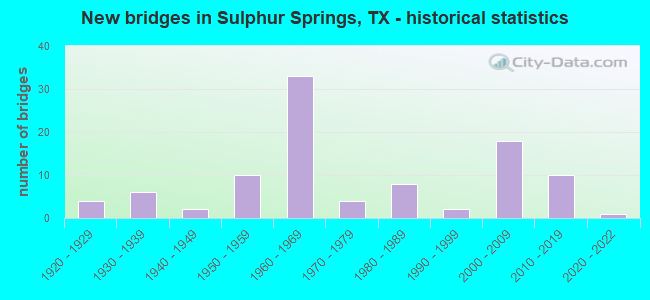
- New bridges - historical statistics
- 41920-1929
- 61930-1939
- 21940-1949
- 101950-1959
- 331960-1969
- 41970-1979
- 81980-1989
- 21990-1999
- 182000-2009
- 102010-2019
- 12020-2022

- Reconstructed bridges - Historical Statistics
- 11940-1949
- 31950-1959
- 31960-1969
- 01970-1979
- 41980-1989
- 21990-1999
- 32000-2009


- Bridge Condition - Deck
- 17.5%Very good
- 43.9%Good
- 31.6%Satisfactory
- 7.0%Fair

- Bridge Condition - Superstructure
- 33.3%Very good
- 28.1%Good
- 22.8%Satisfactory
- 14.0%Fair
- 1.8%Poor

- Bridge Condition - Substructure
- 14.0%Very good
- 45.6%Good
- 33.3%Satisfactory
- 5.3%Fair
- 1.8%Poor

- Bridge Condition - Channel
- 9.2%Very good
- 38.2%Good
- 39.5%Satisfactory
- 13.2%Fair

- Bridge Condition - Culverts
- 3.3%Very good
- 30.0%Good
- 60.0%Satisfactory
- 6.7%Fair
Find on map >> Show street view
Structure Number: 11130000909059, Location: 9.8 MI E HUNT CO LINE (Lat: 33.120642, Lng: -95.693422), Route carried "on" structure: Interstate 30, Year Built: 1925, Year Reconstructed: 1985, Status: Open, Structure Length: 0.67m (2.20ft), Average Daily Traffic: 32,048 (year 2020), Truck Traffic: 38%, Average Future Daily Traffic: 46,064 (year 2039), Design Load: H 15, Features Intersected: RILEY CREEK
Minimum Vertical Clearance: 30+ m (98+ ft), Kilometerpoint: 15.986, Lanes on structure: 8, Owner: State Highway Agency, Approaching Roadway Width: 37.8m (124.0ft), Skew: 30 degrees, Material/Design: Concrete, Design/Construction: Culvert, Number Of Spans In Main Unit: 2, Length of Maximum Span: 3.0m (9.8ft)
Condition: Channel: Good, Culverts: Satisfactory, Operating Rating: 39.9 metric tons, Method Used To Determine Operating Rating: Load Factor (LF), Inventory Rating: 23.6 metric tons, Method Used To Determine Inventory Rating: Load Factor (LF), Structural Evaluation: Somewhat better than minimum adequacy, Waterway Adequacy: Equal to present minimum criteria, Approach Roadway Alignment: Equal to present desirable criteria, Designated Inspection Frequency: Every 24 months, Inspection Date: January 2021
Find on map >> Show street view
Structure Number: 1113000090906, Location: 11.0 MI E HUNT CO LINE (Lat: 33.121039, Lng: -95.675314), Route carried "on" structure: Interstate 30, Year Built: 1925, Year Reconstructed: 1985, Status: Open, Structure Length: 0.67m (2.20ft), Average Daily Traffic: 32,048 (year 2020), Truck Traffic: 38%, Average Future Daily Traffic: 46,389 (year 2039), Design Load: H 15, Features Intersected: LINDLEY CREEK
Minimum Vertical Clearance: 30+ m (98+ ft), Kilometerpoint: 17.650, Lanes on structure: 8, Owner: State Highway Agency, Approaching Roadway Width: 39.6m (129.9ft), Skew: 30 degrees, Material/Design: Concrete, Design/Construction: Culvert, Number Of Spans In Main Unit: 2, Length of Maximum Span: 3.0m (9.8ft)
Condition: Channel: Good, Culverts: Satisfactory, Operating Rating: 39.9 metric tons, Method Used To Determine Operating Rating: Load Factor (LF), Inventory Rating: 23.6 metric tons, Method Used To Determine Inventory Rating: Load Factor (LF), Structural Evaluation: Somewhat better than minimum adequacy, Waterway Adequacy: Equal to present minimum criteria, Approach Roadway Alignment: Equal to present desirable criteria, Designated Inspection Frequency: Every 24 months, Inspection Date: January 2021
Find on map >> Show street view
Structure Number: 11130000909171, Location: 8.7 MI E HUNT CO LINE (Lat: 33.120225, Lng: -95.710467), Route carried "on" structure: ServiceInterstate 30, Year Built: 1958, Status: Open, Structure Length: 2.29m (7.51ft), Average Daily Traffic: 675 (year 2019), Truck Traffic: 7%, Average Future Daily Traffic: 945 (year 2039), Design Load: H 15, Features Intersected: CLENDELING CREEK
Minimum Vertical Clearance: 30+ m (98+ ft), Kilometerpoint: 14.352, Lanes on structure: 2, Owner: State Highway Agency, Approaching Roadway Width: 7.3m (24.0ft), Material/Design: Concrete, Design/Construction: Slab, Number Of Spans In Main Unit: 3, Length of Maximum Span: 7.6m (24.9ft), Curb-To-Curb Width: 7.1m (23.3ft), Out-to-Out Width: 7.7m (25.3ft)
Condition: Deck: Good, Superstructure: Good, Substructure: Good, Channel: Satisfactory, Operating Rating: 44.4 metric tons, Method Used To Determine Operating Rating: Load Factor (LF), Inventory Rating: 26.3 metric tons, Method Used To Determine Inventory Rating: Load Factor (LF), Structural Evaluation: Equal to present minimum criteria, Deck Geometry: Meets minimum limits, Waterway Adequacy: Equal to present minimum criteria, Approach Roadway Alignment: Equal to present desirable criteria, Length Of Structure Improvement: 2.29m (7.51ft), Designated Inspection Frequency: Every 24 months, Inspection Date: January 2021, Bridge Improvement Cost: $3,000, Roadway Improvement Cost: $1,000, Total Project Cost: $4,000, Deck Structure Type: Concrete Cast-file-Place, Wearing Surface/Protective System: Wearing Surface: Bituminous
Find on map >> Show street view
Structure Number: 11130000909172, Location: 8.9 MI E HUNT CO LINE (Lat: 33.120497, Lng: -95.710522), Route carried "on" structure: Interstate 30, Year Built: 1958, Status: Open, Structure Length: 2.29m (7.51ft), Average Daily Traffic: 16,452 (year 2019), Truck Traffic: 38%, Average Future Daily Traffic: 23,032 (year 2039), Design Load: H 20, Features Intersected: CLENDELING CREEK
Minimum Vertical Clearance: 30+ m (98+ ft), Kilometerpoint: 14.352, Lanes on structure: 2, Owner: State Highway Agency, Approaching Roadway Width: 11.6m (38.1ft), Material/Design: Concrete, Design/Construction: Slab, Number Of Spans In Main Unit: 3, Length of Maximum Span: 7.6m (24.9ft), Curb-To-Curb Width: 11.3m (37.1ft), Out-to-Out Width: 12.8m (42.0ft)
Condition: Deck: Satisfactory, Superstructure: Satisfactory, Substructure: Satisfactory, Channel: Satisfactory, Operating Rating: 44.4 metric tons, Method Used To Determine Operating Rating: Load Factor (LF), Inventory Rating: 31.7 metric tons, Method Used To Determine Inventory Rating: Load Factor (LF), Structural Evaluation: Equal to present minimum criteria, Deck Geometry: Somewhat better than minimum adequacy, Waterway Adequacy: Equal to present minimum criteria, Approach Roadway Alignment: Equal to present desirable criteria, Designated Inspection Frequency: Every 24 months, Inspection Date: January 2021, Deck Structure Type: Concrete Cast-file-Place
Find on map >> Show street view
Structure Number: 11130000909173, Location: 8.9 MI E HUNT CO LINE (Lat: 33.120944, Lng: -95.710597), Route carried "on" structure: ServiceInterstate 30, Year Built: 1958, Status: Open, Structure Length: 2.29m (7.51ft), Average Daily Traffic: 433 (year 2019), Truck Traffic: 7%, Average Future Daily Traffic: 520 (year 2039), Design Load: H 15, Features Intersected: CLENDELING CREEK
Minimum Vertical Clearance: 30+ m (98+ ft), Kilometerpoint: 14.352, Lanes on structure: 2, Owner: State Highway Agency, Approaching Roadway Width: 6.7m (22.0ft), Material/Design: Concrete, Design/Construction: Slab, Number Of Spans In Main Unit: 3, Length of Maximum Span: 7.6m (24.9ft), Curb-To-Curb Width: 6.9m (22.6ft), Out-to-Out Width: 7.7m (25.3ft)
Condition: Deck: Good, Superstructure: Good, Substructure: Satisfactory, Channel: Good, Operating Rating: 44.4 metric tons, Method Used To Determine Operating Rating: Load Factor (LF), Inventory Rating: 25.4 metric tons, Method Used To Determine Inventory Rating: Load Factor (LF), Structural Evaluation: Equal to present minimum criteria, Deck Geometry: Meets minimum limits, Waterway Adequacy: Equal to present minimum criteria, Approach Roadway Alignment: Equal to present desirable criteria, Length Of Structure Improvement: 2.29m (7.51ft), Designated Inspection Frequency: Every 24 months, Inspection Date: January 2021, Bridge Improvement Cost: $3,000, Roadway Improvement Cost: $1,000, Total Project Cost: $4,000, Deck Structure Type: Concrete Cast-file-Place, Wearing Surface/Protective System: Wearing Surface: Bituminous
Find on map >> Show street view
Structure Number: 11130000909181, Location: 11.2 MI E HUNT CO LINE (Lat: 33.121228, Lng: -95.671525), Route carried "on" structure: Business State highway 67, Year Built: 1960, Status: Open, Structure Length: 9.75m (31.99ft), Average Daily Traffic: 2,191 (year 2019), Truck Traffic: 2%, Average Future Daily Traffic: 2,270 (year 2033), Design Load: H 20, Features Intersected: IH 30
Minimum Vertical Clearance: 30+ m (98+ ft), Kilometerpoint: 0.459, Lanes on structure: 2, Lanes under structure: 8, Owner: State Highway Agency, Approaching Roadway Width: 9.1m (29.9ft), Skew: 3 degrees, Material/Design: Prestressed concrete, Design/Construction: Stringer/Multi-beam, Number Of Spans In Main Unit: 4, Number Of Approach Spans: 2, Length of Maximum Span: 19.8m (65.0ft), Curb-To-Curb Width: 8.5m (27.9ft), Out-to-Out Width: 9.8m (32.2ft)
Condition: Deck: Satisfactory, Superstructure: Satisfactory, Substructure: Satisfactory, Operating Rating: 68.0 metric tons, Method Used To Determine Operating Rating: Load Factor (LF), Inventory Rating: 34.5 metric tons, Method Used To Determine Inventory Rating: Load Factor (LF), Structural Evaluation: Equal to present minimum criteria, Deck Geometry: Meets minimum limits, Underclear: Meets minimum limits, Approach Roadway Alignment: Somewhat better than minimum adequacy, Designated Inspection Frequency: Every 24 months, Inspection Date: January 2021, Deck Structure Type: Concrete Cast-file-Place, Wearing Surface/Protective System: Wearing Surface: Bituminous
Find on map >> Show street view
Structure Number: 11130000909182, Location: 13.4 MI E HUNT CO LINE (Lat: 33.119892, Lng: -95.633947), Route carried "on" structure: State highway 19, Year Built: 1960, Status: Open, Structure Length: 9.45m (31.00ft), Average Daily Traffic: 9,540 (year 2019), Truck Traffic: 17%, Average Future Daily Traffic: 10,080 (year 2033), Design Load: H 20, Features Intersected: IH 30
Minimum Vertical Clearance: 30+ m (98+ ft), Kilometerpoint: 27.615, Lanes on structure: 2, Lanes under structure: 8, Owner: State Highway Agency, Approaching Roadway Width: 9.4m (30.8ft), Skew: 20 degrees, Material/Design: Prestressed concrete, Design/Construction: Stringer/Multi-beam, Number Of Spans In Main Unit: 4, Number Of Approach Spans: 2, Length of Maximum Span: 19.8m (65.0ft), Curb-To-Curb Width: 8.5m (27.9ft), Out-to-Out Width: 9.8m (32.2ft)
Condition: Deck: Satisfactory, Superstructure: Fair, Substructure: Satisfactory, Operating Rating: 68.0 metric tons, Method Used To Determine Operating Rating: Load Factor (LF), Inventory Rating: 38.1 metric tons, Method Used To Determine Inventory Rating: Load Factor (LF), Structural Evaluation: Somewhat better than minimum adequacy, Deck Geometry: Meets minimum limits, Underclear: Equal to present minimum criteria, Approach Roadway Alignment: Equal to present desirable criteria, Length Of Structure Improvement: 9.45m (31.00ft), Designated Inspection Frequency: Every 24 months, Inspection Date: January 2021, Bridge Improvement Cost: $35,000, Roadway Improvement Cost: $9,000, Total Project Cost: $44,000, Deck Structure Type: Concrete Cast-file-Place
Find on map >> Show street view
Structure Number: 11130000909194, Location: 8.9 MI E HUNT CO LINE (Lat: 33.120678, Lng: -95.710556), Route carried "on" structure: Interstate 30, Year Built: 1960, Status: Open, Structure Length: 2.29m (7.51ft), Average Daily Traffic: 16,452 (year 2019), Truck Traffic: 38%, Average Future Daily Traffic: 23,032 (year 2039), Design Load: H 20, Features Intersected: CLENDELING CREEK
Minimum Vertical Clearance: 30+ m (98+ ft), Kilometerpoint: 14.352, Lanes on structure: 2, Owner: State Highway Agency, Approaching Roadway Width: 11.6m (38.1ft), Material/Design: Concrete, Design/Construction: Slab, Number Of Spans In Main Unit: 3, Length of Maximum Span: 7.6m (24.9ft), Curb-To-Curb Width: 11.3m (37.1ft), Out-to-Out Width: 12.8m (42.0ft)
Condition: Deck: Good, Superstructure: Good, Substructure: Satisfactory, Channel: Satisfactory, Operating Rating: 44.4 metric tons, Method Used To Determine Operating Rating: Load Factor (LF), Inventory Rating: 31.7 metric tons, Method Used To Determine Inventory Rating: Load Factor (LF), Structural Evaluation: Equal to present minimum criteria, Deck Geometry: Somewhat better than minimum adequacy, Waterway Adequacy: Equal to present minimum criteria, Approach Roadway Alignment: Equal to present desirable criteria, Designated Inspection Frequency: Every 24 months, Inspection Date: January 2021, Deck Structure Type: Concrete Cast-file-Place
Find on map >> Show street view
Structure Number: 11130000909195, Location: 9.0 MI E HUNT CO LINE (Lat: 33.120717, Lng: -95.708675), Route carried "on" structure: State highway 3389, Year Built: 1960, Status: Open, Structure Length: 8.84m (29.00ft), Average Daily Traffic: 505 (year 2019), Truck Traffic: 10%, Average Future Daily Traffic: 606 (year 2039), Design Load: H 20, Features Intersected: IH 30
Minimum Vertical Clearance: 30+ m (98+ ft), Kilometerpoint: 7.994, Lanes on structure: 2, Lanes under structure: 8, Base Highway Network: Yes, Owner: State Highway Agency, Approaching Roadway Width: 7.9m (25.9ft), Material/Design: Prestressed concrete, Design/Construction: Stringer/Multi-beam, Number Of Spans In Main Unit: 2, Number Of Approach Spans: 4, Length of Maximum Span: 19.8m (65.0ft), Curb-To-Curb Width: 8.4m (27.6ft), Out-to-Out Width: 9.8m (32.2ft)
Condition: Deck: Fair, Superstructure: Satisfactory, Substructure: Satisfactory, Operating Rating: 44.4 metric tons, Method Used To Determine Operating Rating: Load Factor (LF), Inventory Rating: 32.7 metric tons, Method Used To Determine Inventory Rating: Load Factor (LF), Structural Evaluation: Equal to present minimum criteria, Deck Geometry: Somewhat better than minimum adequacy, Underclear: Somewhat better than minimum adequacy, Approach Roadway Alignment: Equal to present desirable criteria, Designated Inspection Frequency: Every 24 months, Inspection Date: January 2021, Deck Structure Type: Concrete Cast-file-Place
Find on map >> Show street view
Structure Number: 1113000090926, Location: 14.7 MI E HUNT CO LINE (Lat: 33.116336, Lng: -95.612608), Route carried "on" structure: State highway 2297, Year Built: 1962, Status: Open, Structure Length: 10.27m (33.69ft), Average Daily Traffic: 4,516 (year 2019), Truck Traffic: 5%, Average Future Daily Traffic: 5,419 (year 2039), Design Load: H 15, Features Intersected: IH 30
Minimum Vertical Clearance: 30+ m (98+ ft), Kilometerpoint: 0.658, Lanes on structure: 2, Lanes under structure: 8, Base Highway Network: Yes, Owner: State Highway Agency, Approaching Roadway Width: 7.3m (24.0ft), Material/Design: Prestressed concrete, Design/Construction: Stringer/Multi-beam, Number Of Spans In Main Unit: 4, Number Of Approach Spans: 2, Length of Maximum Span: 19.8m (65.0ft), Curb or Sidewalk Widths: Left: 1.1m (3.6ft), Right: 0.0m, Curb-To-Curb Width: 7.3m (24.0ft), Out-to-Out Width: 9.4m (30.8ft)
Condition: Deck: Satisfactory, Superstructure: Good, Substructure: Satisfactory, Operating Rating: 44.4 metric tons, Method Used To Determine Operating Rating: Load Factor (LF), Inventory Rating: 32.7 metric tons, Method Used To Determine Inventory Rating: Load Factor (LF), Structural Evaluation: Equal to present minimum criteria, Deck Geometry: High priority of replacement, Underclear: Equal to present minimum criteria, Approach Roadway Alignment: Equal to present desirable criteria, Length Of Structure Improvement: 10.27m (33.69ft), Designated Inspection Frequency: Every 24 months, Inspection Date: January 2021, Bridge Improvement Cost: $16,000, Roadway Improvement Cost: $4,000, Total Project Cost: $20,000, Deck Structure Type: Concrete Cast-file-Place, Wearing Surface/Protective System: Wearing Surface: Bituminous
Find on map >> Show street view
Structure Number: 11130000909497, Location: 13.4 MI E HUNT CO LINE (Lat: 33.119528, Lng: -95.634167), Route carried "on" structure: State highway 19, Year Built: 1960, Status: Open, Structure Length: 9.45m (31.00ft), Average Daily Traffic: 9,540 (year 2019), Truck Traffic: 17%, Average Future Daily Traffic: 10,080 (year 2033), Design Load: H 20, Features Intersected: IH 30
Minimum Vertical Clearance: 30+ m (98+ ft), Kilometerpoint: 27.615, Lanes on structure: 2, Lanes under structure: 8, Base Highway Network: Yes, Owner: State Highway Agency, Approaching Roadway Width: 9.4m (30.8ft), Skew: 20 degrees, Material/Design: Prestressed concrete, Design/Construction: Stringer/Multi-beam, Number Of Spans In Main Unit: 4, Number Of Approach Spans: 2, Length of Maximum Span: 19.8m (65.0ft), Curb-To-Curb Width: 8.5m (27.9ft), Out-to-Out Width: 9.8m (32.2ft)
Condition: Deck: Satisfactory, Superstructure: Fair, Substructure: Fair, Operating Rating: 68.0 metric tons, Method Used To Determine Operating Rating: Load Factor (LF), Inventory Rating: 38.1 metric tons, Method Used To Determine Inventory Rating: Load Factor (LF), Structural Evaluation: Somewhat better than minimum adequacy, Deck Geometry: Meets minimum limits, Underclear: Equal to present minimum criteria, Approach Roadway Alignment: Equal to present desirable criteria, Designated Inspection Frequency: Every 24 months, Inspection Date: January 2021, Deck Structure Type: Concrete Cast-file-Place
Find on map >> Show street view
Structure Number: 11130000918061, Location: 2.1 MI NE OF IH 30 (Lat: 33.132697, Lng: -95.640608), Route carried "on" structure: Business State highway 67, Year Built: 1925, Year Reconstructed: 1940, Status: Open, Structure Length: 0.67m (2.20ft), Average Daily Traffic: 4,117 (year 2019), Truck Traffic: 5%, Average Future Daily Traffic: 4,940 (year 2039), Features Intersected: BRASHEAR CREEK
Minimum Vertical Clearance: 30+ m (98+ ft), Kilometerpoint: 3.814, Lanes on structure: 2, Owner: State Highway Agency, Approaching Roadway Width: 7.3m (24.0ft), Material/Design: Concrete, Design/Construction: Culvert, Number Of Spans In Main Unit: 2, Length of Maximum Span: 3.0m (9.8ft), Curb-To-Curb Width: 7.9m (25.9ft), Out-to-Out Width: 9.1m (29.9ft)
Condition: Channel: Satisfactory, Culverts: Satisfactory, Operating Rating: 39.9 metric tons, Method Used To Determine Operating Rating: Load Factor (LF), Inventory Rating: 23.6 metric tons, Method Used To Determine Inventory Rating: Load Factor (LF), Structural Evaluation: Equal to present minimum criteria, Deck Geometry: High priority of corrective action, Waterway Adequacy: Equal to present minimum criteria, Approach Roadway Alignment: Equal to present desirable criteria, Length Of Structure Improvement: 0.64m (2.10ft), Designated Inspection Frequency: Every 24 months, Inspection Date: January 2021, Bridge Improvement Cost: $1,000, Total Project Cost: $1,000, Deck Structure Type: Concrete Cast-file-Place, Wearing Surface/Protective System: Wearing Surface: Bituminous
Find on map >> Show street view
Structure Number: 11130000918062, Location: 3.5 MI NE OF IH 30 (Lat: 33.132975, Lng: -95.618733), Route carried "on" structure: Business State highway 67, Year Built: 1925, Year Reconstructed: 1950, Status: Open, Structure Length: 1.07m (3.51ft), Average Daily Traffic: 5,722 (year 2019), Truck Traffic: 5%, Average Future Daily Traffic: 6,866 (year 2039), Design Load: H 15, Features Intersected: LAKE COLEMAN DRAIN
Minimum Vertical Clearance: 30+ m (98+ ft), Kilometerpoint: 5.794, Lanes on structure: 2, Owner: State Highway Agency, Approaching Roadway Width: 7.3m (24.0ft), Material/Design: Concrete, Design/Construction: Culvert, Number Of Spans In Main Unit: 4, Length of Maximum Span: 2.4m (7.9ft), Curb-To-Curb Width: 8.2m (26.9ft), Out-to-Out Width: 9.1m (29.9ft)
Condition: Channel: Good, Culverts: Satisfactory, Operating Rating: 32.7 metric tons, Method Used To Determine Operating Rating: Field evaluation and documented engineering judgment, Inventory Rating: 24.5 metric tons, Method Used To Determine Inventory Rating: Field evaluation and documented engineering judgment, Structural Evaluation: Equal to present minimum criteria, Deck Geometry: High priority of replacement, Waterway Adequacy: Equal to present minimum criteria, Approach Roadway Alignment: Equal to present desirable criteria, Length Of Structure Improvement: 1.77m (5.81ft), Designated Inspection Frequency: Every 24 months, Inspection Date: January 2021, Bridge Improvement Cost: $125,000, Roadway Improvement Cost: $31,000, Total Project Cost: $156,000, Deck Structure Type: Concrete Cast-file-Place, Wearing Surface/Protective System: Wearing Surface: Bituminous
Find on map >> Show street view
Structure Number: 11130000918362, Location: 0.1 MI E OF SH 11 (Lat: 33.138681, Lng: -95.599231), Route carried "on" structure: Business State highway 67, Year Built: 1935, Status: Open, Structure Length: 0.82m (2.69ft), Average Daily Traffic: 2,657 (year 2019), Average Future Daily Traffic: 4,200 (year 2031), Features Intersected: TOWN BRANCH
Minimum Vertical Clearance: 30+ m (98+ ft), Kilometerpoint: 32.629, Lanes on structure: 2, Owner: State Highway Agency, Approaching Roadway Width: 9.8m (32.2ft), Material/Design: Concrete continuous, Design/Construction: Slab, Number Of Spans In Main Unit: 2, Length of Maximum Span: 4.0m (13.1ft), Curb or Sidewalk Widths: Left: 1.8m (5.9ft), Right: 1.8m (5.9ft), Curb-To-Curb Width: 9.6m (31.5ft), Out-to-Out Width: 14.1m (46.3ft)
Condition: Deck: Fair, Superstructure: Fair, Substructure: Fair, Channel: Fair, Operating Rating: 32.7 metric tons, Method Used To Determine Operating Rating: Field evaluation and documented engineering judgment, Inventory Rating: 24.5 metric tons, Method Used To Determine Inventory Rating: Field evaluation and documented engineering judgment, Structural Evaluation: Somewhat better than minimum adequacy, Deck Geometry: Meets minimum limits, Waterway Adequacy: Equal to present minimum criteria, Approach Roadway Alignment: Equal to present desirable criteria, Length Of Structure Improvement: 0.79m (2.59ft), Designated Inspection Frequency: Every 24 months, Inspection Date: January 2021, Bridge Improvement Cost: $13,000, Roadway Improvement Cost: $3,000, Total Project Cost: $16,000, Deck Structure Type: Concrete Cast-file-Place, Wearing Surface/Protective System: Wearing Surface: Bituminous
Find on map >> Show street view
Structure Number: 11130001002101, Location: 5.80 MI E OF SH 19 (Lat: 33.146392, Lng: -95.549472), Route carried "on" structure: Interstate 30, Year Built: 1956, Status: Open, Structure Length: 3.69m (12.11ft), Average Daily Traffic: 18,939 (year 2019), Truck Traffic: 35%, Average Future Daily Traffic: 26,541 (year 2039), Design Load: HS 20, Features Intersected: ROCK CREEK
Minimum Vertical Clearance: 30+ m (98+ ft), Kilometerpoint: 30.985, Lanes on structure: 2, Owner: State Highway Agency, Approaching Roadway Width: 11.6m (38.1ft), Material/Design: Concrete, Design/Construction: Stringer/Multi-beam, Number Of Spans In Main Unit: 4, Length of Maximum Span: 9.1m (29.9ft), Curb-To-Curb Width: 13.2m (43.3ft), Out-to-Out Width: 13.9m (45.6ft)
Condition: Deck: Satisfactory, Superstructure: Satisfactory, Substructure: Satisfactory, Channel: Satisfactory, Operating Rating: 68.0 metric tons, Method Used To Determine Operating Rating: Load Factor (LF), Inventory Rating: 40.8 metric tons, Method Used To Determine Inventory Rating: Load Factor (LF), Structural Evaluation: Equal to present minimum criteria, Deck Geometry: Superior to present desirable criteria, Waterway Adequacy: Equal to present minimum criteria, Approach Roadway Alignment: Equal to present desirable criteria, Designated Inspection Frequency: Every 24 months, Inspection Date: January 2021, Deck Structure Type: Concrete Cast-file-Place, Wearing Surface/Protective System: Wearing Surface: Bituminous
Find on map >> Show street view
Structure Number: 11130001002109, Location: 2.3 MI E OF LP 301 (Lat: 33.147367, Lng: -95.525239), Route carried "on" structure: ServiceCounty highway 109, Year Built: 1962, Status: Open, Structure Length: 5.85m (19.19ft), Average Daily Traffic: 443 (year 2019), Truck Traffic: 3%, Average Future Daily Traffic: 620 (year 2039), Design Load: H 15, Features Intersected: IH 30, Facility Carried by Structure: Country Club Road
Minimum Vertical Clearance: 30+ m (98+ ft), Kilometerpoint: 4.023, Lanes on structure: 2, Lanes under structure: 4, Owner: State Highway Agency, Approaching Roadway Width: 7.3m (24.0ft), Material/Design: Prestressed concrete, Design/Construction: Stringer/Multi-beam, Number Of Spans In Main Unit: 2, Number Of Approach Spans: 2, Length of Maximum Span: 17.4m (57.1ft), Curb-To-Curb Width: 7.3m (24.0ft), Out-to-Out Width: 8.3m (27.2ft)
Condition: Deck: Satisfactory, Superstructure: Good, Substructure: Satisfactory, Operating Rating: 44.4 metric tons, Method Used To Determine Operating Rating: Load Factor (LF), Inventory Rating: 32.7 metric tons, Method Used To Determine Inventory Rating: Load Factor (LF), Structural Evaluation: Equal to present minimum criteria, Deck Geometry: Meets minimum limits, Underclear: High priority of corrective action, Approach Roadway Alignment: Equal to present desirable criteria, Designated Inspection Frequency: Every 24 months, Inspection Date: January 2021, Deck Structure Type: Concrete Cast-file-Place
Find on map >> Show street view
Structure Number: 11130001002114, Location: 2.10 MI E OF SH 11 (Lat: 33.137208, Lng: -95.572433), Route carried "on" structure: State highway 1870, Year Built: 1960, Year Reconstructed: 1987, Status: Open, Structure Length: 9.75m (31.99ft), Average Daily Traffic: 4,470 (year 2013), Truck Traffic: 2%, Average Future Daily Traffic: 6,260 (year 2033), Features Intersected: IH 30
Minimum Vertical Clearance: 30+ m (98+ ft), Kilometerpoint: 0.000, Lanes on structure: 2, Lanes under structure: 8, Owner: State Highway Agency, Approaching Roadway Width: 7.6m (24.9ft), Skew: 1 degrees, Material/Design: Prestressed concrete, Design/Construction: Stringer/Multi-beam, Number Of Spans In Main Unit: 4, Number Of Approach Spans: 2, Length of Maximum Span: 19.8m (65.0ft), Curb-To-Curb Width: 8.6m (28.2ft), Out-to-Out Width: 9.8m (32.2ft)
Condition: Deck: Satisfactory, Superstructure: Fair, Substructure: Good, Operating Rating: 49.0 metric tons, Method Used To Determine Operating Rating: Load Factor (LF), Inventory Rating: 29.0 metric tons, Method Used To Determine Inventory Rating: Load Factor (LF), Structural Evaluation: Somewhat better than minimum adequacy, Deck Geometry: Meets minimum limits, Underclear: Meets minimum limits, Approach Roadway Alignment: Equal to present desirable criteria, Designated Inspection Frequency: Every 24 months, Inspection Date: January 2021, Deck Structure Type: Concrete Cast-file-Place
Find on map >> Show street view
Structure Number: 11130001002117, Location: 5.60 MI E OF SH 19 (Lat: 33.145756, Lng: -95.552647), Route carried "on" structure: Interstate 30, Year Built: 1960, Status: Open, Structure Length: 5.55m (18.21ft), Average Daily Traffic: 18,003 (year 2019), Truck Traffic: 31%, Average Future Daily Traffic: 17,930 (year 2033), Design Load: HS 20, Features Intersected: ROCK CREEK RELIEF #2
Minimum Vertical Clearance: 30+ m (98+ ft), Kilometerpoint: 30.729, Lanes on structure: 2, Base Highway Network: Yes, Owner: State Highway Agency, Approaching Roadway Width: 11.6m (38.1ft), Material/Design: Concrete, Design/Construction: Stringer/Multi-beam, Number Of Spans In Main Unit: 6, Length of Maximum Span: 9.1m (29.9ft), Curb-To-Curb Width: 11.6m (38.1ft), Out-to-Out Width: 12.1m (39.7ft)
Condition: Deck: Satisfactory, Superstructure: Fair, Substructure: Good, Channel: Very good, Operating Rating: 68.0 metric tons, Method Used To Determine Operating Rating: Load Factor (LF), Inventory Rating: 40.8 metric tons, Method Used To Determine Inventory Rating: Load Factor (LF), Structural Evaluation: Somewhat better than minimum adequacy, Deck Geometry: Equal to present minimum criteria, Waterway Adequacy: Equal to present minimum criteria, Approach Roadway Alignment: Equal to present desirable criteria, Designated Inspection Frequency: Every 24 months, Inspection Date: January 2021, Deck Structure Type: Concrete Cast-file-Place, Wearing Surface/Protective System: Wearing Surface: Bituminous
Find on map >> Show street view
Structure Number: 11130001002118, Location: 5.60 MI E OF SH 19 (Lat: 33.145572, Lng: -95.552611), Route carried "on" structure: ServiceInterstate 30, Year Built: 1960, Status: Open, Structure Length: 5.55m (18.21ft), Average Daily Traffic: 950 (year 2013), Truck Traffic: 31%, Average Future Daily Traffic: 1,330 (year 2033), Design Load: H 15, Features Intersected: ROCK CREEK RELIEF #2
Minimum Vertical Clearance: 30+ m (98+ ft), Kilometerpoint: 30.729, Lanes on structure: 2, Owner: State Highway Agency, Approaching Roadway Width: 7.3m (24.0ft), Material/Design: Concrete, Design/Construction: Stringer/Multi-beam, Number Of Spans In Main Unit: 6, Length of Maximum Span: 9.1m (29.9ft), Curb-To-Curb Width: 7.7m (25.3ft), Out-to-Out Width: 8.4m (27.6ft)
Condition: Deck: Good, Superstructure: Good, Substructure: Good, Channel: Good, Operating Rating: 44.4 metric tons, Method Used To Determine Operating Rating: Load Factor (LF), Inventory Rating: 31.7 metric tons, Method Used To Determine Inventory Rating: Load Factor (LF), Structural Evaluation: Better than present minimum criteria, Deck Geometry: Meets minimum limits, Waterway Adequacy: Better than present minimum criteria, Approach Roadway Alignment: Equal to present desirable criteria, Length Of Structure Improvement: 5.49m (18.01ft), Designated Inspection Frequency: Every 24 months, Inspection Date: January 2021, Deck Structure Type: Concrete Cast-file-Place, Wearing Surface/Protective System: Wearing Surface: Bituminous
Find on map >> Show street view
Structure Number: 11130001002119, Location: 5.70 MI E OF SH 19 (Lat: 33.145964, Lng: -95.551006), Route carried "on" structure: Interstate 30, Year Built: 1960, Status: Open, Structure Length: 2.77m (9.09ft), Average Daily Traffic: 18,003 (year 2019), Truck Traffic: 31%, Average Future Daily Traffic: 17,930 (year 2033), Design Load: HS 20, Features Intersected: ROCK CREEK RELIEF #3
Minimum Vertical Clearance: 30+ m (98+ ft), Kilometerpoint: 30.911, Lanes on structure: 2, Owner: State Highway Agency, Approaching Roadway Width: 11.6m (38.1ft), Material/Design: Concrete, Design/Construction: Stringer/Multi-beam, Number Of Spans In Main Unit: 3, Length of Maximum Span: 9.1m (29.9ft), Curb-To-Curb Width: 11.3m (37.1ft), Out-to-Out Width: 12.1m (39.7ft)
Condition: Deck: Satisfactory, Superstructure: Fair, Substructure: Good, Channel: Very good, Operating Rating: 68.0 metric tons, Method Used To Determine Operating Rating: Load Factor (LF), Inventory Rating: 40.8 metric tons, Method Used To Determine Inventory Rating: Load Factor (LF), Structural Evaluation: Somewhat better than minimum adequacy, Deck Geometry: Somewhat better than minimum adequacy, Waterway Adequacy: Equal to present minimum criteria, Approach Roadway Alignment: Equal to present desirable criteria, Designated Inspection Frequency: Every 24 months, Inspection Date: January 2021, Deck Structure Type: Concrete Cast-file-Place, Wearing Surface/Protective System: Wearing Surface: Bituminous
Find on map >> Show street view
Structure Number: 1113000100212, Location: 5.70 MI E OF SH 19 (Lat: 33.145758, Lng: -95.550972), Route carried "on" structure: ServiceInterstate 30, Year Built: 1960, Status: Open, Structure Length: 2.77m (9.09ft), Average Daily Traffic: 950 (year 2013), Truck Traffic: 31%, Average Future Daily Traffic: 1,330 (year 2033), Features Intersected: ROCK CREEK RELIEF #3
Minimum Vertical Clearance: 30+ m (98+ ft), Kilometerpoint: 30.883, Lanes on structure: 2, Owner: State Highway Agency, Approaching Roadway Width: 7.3m (24.0ft), Material/Design: Concrete, Design/Construction: Stringer/Multi-beam, Number Of Spans In Main Unit: 3, Length of Maximum Span: 9.1m (29.9ft), Curb-To-Curb Width: 7.7m (25.3ft), Out-to-Out Width: 8.4m (27.6ft)
Condition: Deck: Good, Superstructure: Good, Substructure: Very good, Channel: Good, Operating Rating: 52.6 metric tons, Method Used To Determine Operating Rating: Load Factor (LF), Inventory Rating: 30.8 metric tons, Method Used To Determine Inventory Rating: Load Factor (LF), Structural Evaluation: Better than present minimum criteria, Deck Geometry: Meets minimum limits, Waterway Adequacy: Equal to present minimum criteria, Approach Roadway Alignment: Equal to present desirable criteria, Length Of Structure Improvement: 2.77m (9.09ft), Designated Inspection Frequency: Every 24 months, Inspection Date: January 2021, Deck Structure Type: Concrete Cast-file-Place, Wearing Surface/Protective System: Wearing Surface: Bituminous
Find on map >> Show street view
Structure Number: 11130001002121, Location: 5.80 MI E OF SH 19 (Lat: 33.146106, Lng: -95.549789), Route carried "on" structure: Interstate 30, Year Built: 1960, Status: Open, Structure Length: 3.69m (12.11ft), Average Daily Traffic: 18,939 (year 2019), Truck Traffic: 35%, Average Future Daily Traffic: 26,514 (year 2039), Design Load: HS 20, Features Intersected: ROCK CREEK
Minimum Vertical Clearance: 30+ m (98+ ft), Kilometerpoint: 31.012, Lanes on structure: 2, Owner: State Highway Agency, Approaching Roadway Width: 11.6m (38.1ft), Material/Design: Concrete, Design/Construction: Stringer/Multi-beam, Number Of Spans In Main Unit: 4, Length of Maximum Span: 9.1m (29.9ft), Curb-To-Curb Width: 11.3m (37.1ft), Out-to-Out Width: 12.1m (39.7ft)
Condition: Deck: Satisfactory, Superstructure: Satisfactory, Substructure: Good, Channel: Satisfactory, Operating Rating: 68.0 metric tons, Method Used To Determine Operating Rating: Load Factor (LF), Inventory Rating: 40.8 metric tons, Method Used To Determine Inventory Rating: Load Factor (LF), Structural Evaluation: Equal to present minimum criteria, Deck Geometry: Somewhat better than minimum adequacy, Waterway Adequacy: Equal to present minimum criteria, Approach Roadway Alignment: Equal to present desirable criteria, Designated Inspection Frequency: Every 24 months, Inspection Date: January 2021, Deck Structure Type: Concrete Cast-file-Place, Wearing Surface/Protective System: Wearing Surface: Bituminous
Find on map >> Show street view
Structure Number: 11130001002122, Location: 5.80 MI E OF SH 19 (Lat: 33.145914, Lng: -95.549758), Route carried "on" structure: ServiceInterstate 30, Year Built: 1960, Status: Open, Structure Length: 3.69m (12.11ft), Average Daily Traffic: 944 (year 2019), Truck Traffic: 7%, Average Future Daily Traffic: 1,133 (year 2039), Design Load: H 15, Features Intersected: ROCK CREEK
Minimum Vertical Clearance: 30+ m (98+ ft), Kilometerpoint: 30.985, Lanes on structure: 2, Owner: State Highway Agency, Approaching Roadway Width: 7.3m (24.0ft), Material/Design: Concrete, Design/Construction: Stringer/Multi-beam, Number Of Spans In Main Unit: 4, Length of Maximum Span: 9.1m (29.9ft), Curb-To-Curb Width: 7.7m (25.3ft), Out-to-Out Width: 8.4m (27.6ft)
Condition: Deck: Good, Superstructure: Good, Substructure: Good, Channel: Fair, Operating Rating: 52.6 metric tons, Method Used To Determine Operating Rating: Load Factor (LF), Inventory Rating: 31.7 metric tons, Method Used To Determine Inventory Rating: Load Factor (LF), Structural Evaluation: Better than present minimum criteria, Deck Geometry: Meets minimum limits, Waterway Adequacy: Equal to present minimum criteria, Approach Roadway Alignment: Equal to present desirable criteria, Length Of Structure Improvement: 3.69m (12.11ft), Designated Inspection Frequency: Every 24 months, Inspection Date: January 2021, Deck Structure Type: Concrete Cast-file-Place, Wearing Surface/Protective System: Wearing Surface: Bituminous
Find on map >> Show street view
Structure Number: 11130001002146, Location: 0.9 MI E OF FM 2297 (Lat: 33.116378, Lng: -95.596447), Route carried "on" structure: State highway 11, Year Built: 1994, Status: Open, Structure Length: 7.01m (23.00ft), Average Daily Traffic: 17,570 (year 2010), Truck Traffic: 11%, Average Future Daily Traffic: 24,600 (year 2030), Design Load: HS 20, Features Intersected: IH 30, Facility Carried by Structure: SH 154
Minimum Vertical Clearance: 30+ m (98+ ft), Kilometerpoint: 2.449, Lanes on structure: 6, Lanes under structure: 4, Owner: State Highway Agency, Approaching Roadway Width: 19.5m (64.0ft), Material/Design: Prestressed concrete, Design/Construction: Box Beam or Girders - Multiple, Number Of Spans In Main Unit: 4, Length of Maximum Span: 18.3m (60.0ft), Curb or Sidewalk Widths: Left: 1.4m (4.6ft), Right: 1.4m (4.6ft), Curb-To-Curb Width: 23.8m (78.1ft), Out-to-Out Width: 27.2m (89.2ft)
Condition: Deck: Fair, Superstructure: Fair, Substructure: Good, Operating Rating: 54.4 metric tons, Method Used To Determine Operating Rating: Assigned rating based on Load Factor Design (LFD) reported in metric tons, Inventory Rating: 32.7 metric tons, Method Used To Determine Inventory Rating: Assigned rating based on Load Factor Design (LFD) reported in metric tons, Structural Evaluation: Somewhat better than minimum adequacy, Deck Geometry: Somewhat better than minimum adequacy, Underclear: Meets minimum limits, Approach Roadway Alignment: Equal to present desirable criteria, Length Of Structure Improvement: 7.01m (23.00ft), Designated Inspection Frequency: Every 24 months, Inspection Date: January 2021, Bridge Improvement Cost: $359,000, Roadway Improvement Cost: $90,000, Total Project Cost: $449,000, Deck Structure Type: Concrete Cast-file-Place, Wearing Surface/Protective System: Wearing Surface: Bituminous
Find on map >> Show street view
Structure Number: 11130001002148, Location: 3.70 MI W OF FM 69 (Lat: 33.145442, Lng: -95.553525), Route carried "on" structure: Interstate 30, Year Built: 1956, Year Reconstructed: 1988, Status: Open, Structure Length: 1.34m (4.40ft), Average Daily Traffic: 19,874 (year 2019), Truck Traffic: 42%, Average Future Daily Traffic: 34,060 (year 2030), Features Intersected: ROCK CREEK RELIEF #1
Minimum Vertical Clearance: 30+ m (98+ ft), Kilometerpoint: 30.631, Lanes on structure: 6, Base Highway Network: Yes, Owner: State Highway Agency, Approaching Roadway Width: 30.5m (100.1ft), Skew: 10 degrees, Material/Design: Concrete, Design/Construction: Culvert, Number Of Spans In Main Unit: 5, Length of Maximum Span: 2.4m (7.9ft)
Condition: Channel: Good, Culverts: Satisfactory, Operating Rating: 39.9 metric tons, Method Used To Determine Operating Rating: Load Factor (LF), Inventory Rating: 23.6 metric tons, Method Used To Determine Inventory Rating: Load Factor (LF), Structural Evaluation: Somewhat better than minimum adequacy, Waterway Adequacy: Equal to present minimum criteria, Approach Roadway Alignment: Equal to present desirable criteria, Designated Inspection Frequency: Every 24 months, Inspection Date: January 2021
Find on map >> Show street view
Structure Number: 11130001002152, Location: 3.70 MI W OF FM 69 (Lat: 33.146286, Lng: -95.553519), Route carried "on" structure: ServiceInterstate 30, Year Built: 2001, Status: Open, Structure Length: 1.31m (4.30ft), Average Daily Traffic: 860 (year 2013), Truck Traffic: 31%, Average Future Daily Traffic: 1,200 (year 2033), Design Load: HS 20, Features Intersected: ROCK CREEK RELIEF #1
Minimum Vertical Clearance: 30+ m (98+ ft), Kilometerpoint: 30.658, Lanes on structure: 2, Owner: State Highway Agency, Approaching Roadway Width: 8.5m (27.9ft), Material/Design: Concrete, Design/Construction: Culvert, Number Of Spans In Main Unit: 4, Length of Maximum Span: 3.0m (9.8ft), Curb-To-Curb Width: 9.0m (29.5ft), Out-to-Out Width: 9.8m (32.2ft)
Condition: Channel: Satisfactory, Culverts: Satisfactory, Operating Rating: 54.4 metric tons, Method Used To Determine Operating Rating: No rating analysis performed, Inventory Rating: 32.7 metric tons, Method Used To Determine Inventory Rating: No rating analysis performed, Structural Evaluation: Equal to present minimum criteria, Deck Geometry: Somewhat better than minimum adequacy, Waterway Adequacy: Better than present minimum criteria, Approach Roadway Alignment: Equal to present desirable criteria, Designated Inspection Frequency: Every 48 months, Inspection Date: January 2021, Deck Structure Type: Concrete Cast-file-Place, Wearing Surface/Protective System: Wearing Surface: Monolithic Concrete
Find on map >> Show street view
Structure Number: 11130001002153, Location: 5.60 MI E OF SH 19 (Lat: 33.146381, Lng: -95.552172), Route carried "on" structure: ServiceInterstate 30, Year Built: 2001, Status: Open, Structure Length: 5.49m (18.01ft), Average Daily Traffic: 4,720 (year 2013), Truck Traffic: 28%, Average Future Daily Traffic: 6,610 (year 2033), Design Load: HS 20, Features Intersected: ROCK CREEK RELIEF #2
Minimum Vertical Clearance: 30+ m (98+ ft), Kilometerpoint: 29.477, Lanes on structure: 2, Base Highway Network: Yes, Owner: State Highway Agency, Approaching Roadway Width: 8.5m (27.9ft), Material/Design: Prestressed concrete, Design/Construction: Stringer/Multi-beam, Number Of Spans In Main Unit: 3, Length of Maximum Span: 18.3m (60.0ft), Curb-To-Curb Width: 9.1m (29.9ft), Out-to-Out Width: 9.8m (32.2ft)
Condition: Deck: Good, Superstructure: Very good, Substructure: Good, Channel: Very good, Operating Rating: 68.0 metric tons, Method Used To Determine Operating Rating: Load Factor (LF), Inventory Rating: 38.1 metric tons, Method Used To Determine Inventory Rating: Load Factor (LF), Structural Evaluation: Better than present minimum criteria, Deck Geometry: Meets minimum limits, Waterway Adequacy: Superior to present desirable criteria, Approach Roadway Alignment: Equal to present desirable criteria, Designated Inspection Frequency: Every 24 months, Inspection Date: January 2021, Deck Structure Type: Concrete Cast-file-Place
Find on map >> Show street view
Structure Number: 11130001002154, Location: 5.70 MI E OF SH 19 (Lat: 33.146483, Lng: -95.550778), Route carried "on" structure: ServiceInterstate 30, Year Built: 2001, Status: Open, Structure Length: 2.74m (8.99ft), Average Daily Traffic: 4,720 (year 2013), Truck Traffic: 28%, Average Future Daily Traffic: 6,610 (year 2033), Design Load: HS 20, Features Intersected: ROCK CREEK RELIEF #3
Minimum Vertical Clearance: 30+ m (98+ ft), Kilometerpoint: 29.478, Lanes on structure: 2, Base Highway Network: Yes, Owner: State Highway Agency, Approaching Roadway Width: 8.5m (27.9ft), Material/Design: Prestressed concrete, Design/Construction: Stringer/Multi-beam, Number Of Spans In Main Unit: 2, Length of Maximum Span: 13.7m (44.9ft), Curb-To-Curb Width: 9.1m (29.9ft), Out-to-Out Width: 9.8m (32.2ft)
Condition: Deck: Good, Superstructure: Very good, Substructure: Good, Channel: Very good, Operating Rating: 55.3 metric tons, Method Used To Determine Operating Rating: Load Factor (LF), Inventory Rating: 33.6 metric tons, Method Used To Determine Inventory Rating: Load Factor (LF), Structural Evaluation: Better than present minimum criteria, Deck Geometry: Meets minimum limits, Waterway Adequacy: Superior to present desirable criteria, Approach Roadway Alignment: Equal to present desirable criteria, Designated Inspection Frequency: Every 24 months, Inspection Date: January 2021, Deck Structure Type: Concrete Precast Panels
Find on map >> Show street view
Structure Number: 11130001002155, Location: 5.80 MI E OF SH 19 (Lat: 33.146650, Lng: -95.549492), Route carried "on" structure: ServiceInterstate 30, Year Built: 2002, Status: Open, Structure Length: 3.66m (12.01ft), Average Daily Traffic: 4,720 (year 2013), Truck Traffic: 28%, Average Future Daily Traffic: 6,610 (year 2033), Design Load: HS 20, Features Intersected: ROCK CREEK
Minimum Vertical Clearance: 30+ m (98+ ft), Kilometerpoint: 29.480, Lanes on structure: 2, Owner: State Highway Agency, Approaching Roadway Width: 8.5m (27.9ft), Material/Design: Prestressed concrete, Design/Construction: Stringer/Multi-beam, Number Of Spans In Main Unit: 1, Number Of Approach Spans: 2, Length of Maximum Span: 18.3m (60.0ft), Curb-To-Curb Width: 9.1m (29.9ft), Out-to-Out Width: 9.8m (32.2ft)
Condition: Deck: Good, Superstructure: Very good, Substructure: Very good, Channel: Good, Operating Rating: 68.0 metric tons, Method Used To Determine Operating Rating: Load Factor (LF), Inventory Rating: 38.1 metric tons, Method Used To Determine Inventory Rating: Load Factor (LF), Structural Evaluation: Equal to present desirable criteria, Deck Geometry: Meets minimum limits, Waterway Adequacy: Better than present minimum criteria, Approach Roadway Alignment: Equal to present desirable criteria, Designated Inspection Frequency: Every 24 months, Inspection Date: January 2021, Deck Structure Type: Concrete Cast-file-Place
Find on map >> Show street view
Structure Number: 11130001002158, Location: 0.7 MI NE OF SH 11 (Lat: 33.120233, Lng: -95.584792), Route carried "on" structure: Interstate 30, Year Built: 2003, Status: Open, Structure Length: 6.55m (21.49ft), Average Daily Traffic: 19,139 (year 2019), Truck Traffic: 36%, Average Future Daily Traffic: 18,300 (year 2030), Design Load: HS 20, Features Intersected: BILL BRADFORD RD
Minimum Vertical Clearance: 30+ m (98+ ft), Kilometerpoint: 27.269, Lanes on structure: 2, Lanes under structure: 6, Base Highway Network: Yes, Owner: State Highway Agency, Approaching Roadway Width: 14.0m (45.9ft), Material/Design: Prestressed concrete, Design/Construction: Stringer/Multi-beam, Number Of Spans In Main Unit: 3, Length of Maximum Span: 24.4m (80.1ft), Curb-To-Curb Width: 11.3m (37.1ft), Out-to-Out Width: 12.2m (40.0ft)
Condition: Deck: Satisfactory, Superstructure: Very good, Substructure: Good, Operating Rating: 67.1 metric tons, Method Used To Determine Operating Rating: Load Factor (LF), Inventory Rating: 39.9 metric tons, Method Used To Determine Inventory Rating: Load Factor (LF), Structural Evaluation: Better than present minimum criteria, Deck Geometry: Somewhat better than minimum adequacy, Underclear: Superior to present desirable criteria, Approach Roadway Alignment: Equal to present desirable criteria, Designated Inspection Frequency: Every 24 months, Inspection Date: January 2021, Deck Structure Type: Concrete Precast Panels
Find on map >> Show street view
Structure Number: 11130001002159, Location: 0.7 MI NE OF SH 11 (Lat: 33.120528, Lng: -95.585192), Route carried "on" structure: Interstate 30, Year Built: 2003, Status: Open, Structure Length: 6.10m (20.01ft), Average Daily Traffic: 20,485 (year 2019), Truck Traffic: 36%, Average Future Daily Traffic: 15,000 (year 2027), Design Load: HS 20, Features Intersected: BILL BRADFORD RD
Minimum Vertical Clearance: 30+ m (98+ ft), Kilometerpoint: 27.269, Lanes on structure: 2, Lanes under structure: 6, Base Highway Network: Yes, Owner: State Highway Agency, Approaching Roadway Width: 14.0m (45.9ft), Material/Design: Prestressed concrete, Design/Construction: Stringer/Multi-beam, Number Of Spans In Main Unit: 3, Length of Maximum Span: 24.4m (80.1ft), Curb-To-Curb Width: 11.3m (37.1ft), Out-to-Out Width: 12.2m (40.0ft)
Condition: Deck: Good, Superstructure: Good, Substructure: Satisfactory, Operating Rating: 68.0 metric tons, Method Used To Determine Operating Rating: Load Factor (LF), Inventory Rating: 40.8 metric tons, Method Used To Determine Inventory Rating: Load Factor (LF), Structural Evaluation: Equal to present minimum criteria, Deck Geometry: Somewhat better than minimum adequacy, Underclear: Superior to present desirable criteria, Approach Roadway Alignment: Equal to present desirable criteria, Designated Inspection Frequency: Every 24 months, Inspection Date: January 2021, Deck Structure Type: Concrete Precast Panels
Find on map >> Show street view
Structure Number: 11130001002257, Location: 2.80 MI E OF SH 11 (Lat: 33.143433, Lng: -95.565022), Route carried "on" structure: State highway 301, Year Built: 1960, Status: Open, Structure Length: 7.32m (24.02ft), Average Daily Traffic: 4,040 (year 2013), Truck Traffic: 28%, Average Future Daily Traffic: 5,660 (year 2033), Features Intersected: IH 30
Minimum Vertical Clearance: 30+ m (98+ ft), Kilometerpoint: 29.552, Lanes on structure: 2, Lanes under structure: 4, Owner: State Highway Agency, Approaching Roadway Width: 11.0m (36.1ft), Skew: 3 degrees, Material/Design: Prestressed concrete, Design/Construction: Stringer/Multi-beam, Number Of Spans In Main Unit: 4, Length of Maximum Span: 19.8m (65.0ft), Curb-To-Curb Width: 8.5m (27.9ft), Out-to-Out Width: 10.2m (33.5ft)
Condition: Deck: Satisfactory, Superstructure: Fair, Substructure: Satisfactory, Operating Rating: 68.0 metric tons, Method Used To Determine Operating Rating: Load Factor (LF), Inventory Rating: 37.2 metric tons, Method Used To Determine Inventory Rating: Load Factor (LF), Structural Evaluation: Somewhat better than minimum adequacy, Deck Geometry: Meets minimum limits, Underclear: High priority of corrective action, Approach Roadway Alignment: Equal to present desirable criteria, Length Of Structure Improvement: 7.32m (24.02ft), Designated Inspection Frequency: Every 24 months, Inspection Date: January 2021, Bridge Improvement Cost: $13,000, Roadway Improvement Cost: $3,000, Total Project Cost: $16,000, Deck Structure Type: Concrete Cast-file-Place
Find on map >> Show street view
Structure Number: 11130001002259, Location: 5.60 Mi E of SH 19 (Lat: 33.146069, Lng: -95.552161), Route carried "on" structure: Interstate 30, Year Built: 2013, Status: Open, Structure Length: 6.10m (20.01ft), Average Daily Traffic: 19,874 (year 2019), Truck Traffic: 31%, Average Future Daily Traffic: 17,930 (year 2033), Design Load: HL 93, Features Intersected: Rock Creek Relief #2
Minimum Vertical Clearance: 30+ m (98+ ft), Kilometerpoint: 30.729, Lanes on structure: 2, Base Highway Network: Yes, Owner: State Highway Agency, Approaching Roadway Width: 11.6m (38.1ft), Material/Design: Prestressed concrete, Number Of Spans In Main Unit: 4, Length of Maximum Span: 15.9m (52.2ft), Curb-To-Curb Width: 13.4m (44.0ft), Out-to-Out Width: 14.0m (45.9ft)
Condition: Deck: Good, Superstructure: Very good, Substructure: Very good, Channel: Good, Operating Rating: 54.4 metric tons, Method Used To Determine Operating Rating: Assigned ratings based on Load and Resistance Factor Design (LRFD) reported in metric tons, Inventory Rating: 32.7 metric tons, Method Used To Determine Inventory Rating: Assigned ratings based on Load and Resistance Factor Design (LRFD) reported in metric tons, Structural Evaluation: Equal to present desirable criteria, Deck Geometry: Superior to present desirable criteria, Waterway Adequacy: Superior to present desirable criteria, Approach Roadway Alignment: Equal to present desirable criteria, Designated Inspection Frequency: Every 24 months, Inspection Date: January 2021, Deck Structure Type: Concrete Cast-file-Place
Find on map >> Show street view
Structure Number: 1113000100226, Location: 5.70 MIE OF SH 19 (Lat: 33.146228, Lng: -95.550794), Route carried "on" structure: Interstate 30, Year Built: 2013, Status: Open, Structure Length: 3.35m (10.99ft), Average Daily Traffic: 19,874 (year 2019), Truck Traffic: 31%, Average Future Daily Traffic: 17,930 (year 2033), Design Load: HL 93, Features Intersected: ROCK CREEK RELIEF #3
Minimum Vertical Clearance: 30+ m (98+ ft), Kilometerpoint: 30.883, Lanes on structure: 2, Base Highway Network: Yes, Owner: State Highway Agency, Approaching Roadway Width: 13.4m (44.0ft), Material/Design: Prestressed concrete, Number Of Spans In Main Unit: 3, Length of Maximum Span: 15.2m (49.9ft), Curb-To-Curb Width: 13.4m (44.0ft), Out-to-Out Width: 14.0m (45.9ft)
Condition: Deck: Good, Superstructure: Very good, Substructure: Very good, Channel: Very good, Operating Rating: 54.4 metric tons, Method Used To Determine Operating Rating: Assigned ratings based on Load and Resistance Factor Design (LRFD) reported in metric tons, Inventory Rating: 32.7 metric tons, Method Used To Determine Inventory Rating: Assigned ratings based on Load and Resistance Factor Design (LRFD) reported in metric tons, Structural Evaluation: Equal to present desirable criteria, Deck Geometry: Superior to present desirable criteria, Waterway Adequacy: Superior to present desirable criteria, Approach Roadway Alignment: Equal to present desirable criteria, Designated Inspection Frequency: Every 24 months, Inspection Date: January 2021, Deck Structure Type: Concrete Cast-file-Place
Find on map >> Show street view
Structure Number: 11130008302011, Location: 1.0 MI W OF SH 19 (Lat: 33.142192, Lng: -95.646119), Route carried "on" structure: County highway 4824, Year Built: 1932, Status: Open, Structure Length: 0.67m (2.20ft), Average Daily Traffic: 5,001 (year 2020), Average Future Daily Traffic: 3,500 (year 2031), Design Load: H 15, Features Intersected: BRUSHY CREEK
Minimum Vertical Clearance: 30+ m (98+ ft), Kilometerpoint: 38.489, Lanes on structure: 2, Owner: City or Municipal Highway Agency, Approaching Roadway Width: 7.3m (24.0ft), Material/Design: Concrete, Design/Construction: Culvert, Number Of Spans In Main Unit: 4, Length of Maximum Span: 1.5m (4.9ft), Curb-To-Curb Width: 7.3m (24.0ft), Out-to-Out Width: 8.2m (26.9ft)
Condition: Channel: Satisfactory, Culverts: Satisfactory, Operating Rating: 68.0 metric tons, Method Used To Determine Operating Rating: Load Factor (LF), Inventory Rating: 40.8 metric tons, Method Used To Determine Inventory Rating: Load Factor (LF), Structural Evaluation: Equal to present minimum criteria, Deck Geometry: High priority of replacement, Waterway Adequacy: Equal to present minimum criteria, Approach Roadway Alignment: Somewhat better than minimum adequacy, Length Of Structure Improvement: 0.67m (2.20ft), Designated Inspection Frequency: Every 24 months, Inspection Date: October 2021, Bridge Improvement Cost: $1,000, Total Project Cost: $1,000, Deck Structure Type: Concrete Cast-file-Place, Wearing Surface/Protective System: Wearing Surface: Bituminous
Find on map >> Show street view
Structure Number: 11130008302043, Location: 4.0 MI W OF SH 19 (Lat: 33.163944, Lng: -95.690447), Route carried "on" structure: State highway 11, Year Built: 1954, Year Reconstructed: 2012, Status: Open, Structure Length: 1.28m (4.20ft), Average Daily Traffic: 1,853 (year 2020), Truck Traffic: 38%, Average Future Daily Traffic: 1,904 (year 2039), Features Intersected: BLACKS CREEK
Minimum Vertical Clearance: 30+ m (98+ ft), Kilometerpoint: 33.518, Lanes on structure: 2, Owner: State Highway Agency, Approaching Roadway Width: 7.3m (24.0ft), Material/Design: Concrete, Design/Construction: Culvert, Number Of Spans In Main Unit: 4, Length of Maximum Span: 3.0m (9.8ft)
Condition: Channel: Satisfactory, Culverts: Satisfactory, Operating Rating: 39.9 metric tons, Method Used To Determine Operating Rating: Load Factor (LF), Inventory Rating: 23.6 metric tons, Method Used To Determine Inventory Rating: Load Factor (LF), Structural Evaluation: Equal to present minimum criteria, Waterway Adequacy: Equal to present minimum criteria, Approach Roadway Alignment: Equal to present desirable criteria, Designated Inspection Frequency: Every 24 months, Inspection Date: January 2021
Find on map >> Show street view
Structure Number: 1113000830206, Location: 0.60 MI E OF SH 19 (Lat: 33.141597, Lng: -95.619144), Route carried "on" structure: State highway 11, Year Built: 1974, Status: Open, Structure Length: 0.79m (2.59ft), Average Daily Traffic: 6,244 (year 2020), Truck Traffic: 21%, Average Future Daily Traffic: 4,320 (year 2030), Design Load: HS 20, Features Intersected: LAKE COLEMAN DRAIN
Minimum Vertical Clearance: 30+ m (98+ ft), Kilometerpoint: 41.025, Lanes on structure: 4, Owner: State Highway Agency, Approaching Roadway Width: 14.6m (47.9ft), Material/Design: Concrete, Design/Construction: Culvert, Number Of Spans In Main Unit: 3, Length of Maximum Span: 2.4m (7.9ft), Curb or Sidewalk Widths: Left: 1.3m (4.3ft), Right: 1.3m (4.3ft), Curb-To-Curb Width: 14.6m (47.9ft), Out-to-Out Width: 19.3m (63.3ft)
Condition: Channel: Good, Culverts: Good, Operating Rating: 39.9 metric tons, Method Used To Determine Operating Rating: Load Factor (LF), Inventory Rating: 23.6 metric tons, Method Used To Determine Inventory Rating: Load Factor (LF), Structural Evaluation: Somewhat better than minimum adequacy, Deck Geometry: High priority of replacement, Waterway Adequacy: Equal to present minimum criteria, Approach Roadway Alignment: Equal to present desirable criteria, Length Of Structure Improvement: 0.76m (2.49ft), Designated Inspection Frequency: Every 24 months, Inspection Date: January 2021, Bridge Improvement Cost: $2,000, Roadway Improvement Cost: $1,000, Total Project Cost: $3,000, Deck Structure Type: Concrete Cast-file-Place, Wearing Surface/Protective System: Wearing Surface: Bituminous
Find on map >> Show street view
Structure Number: 11130008302062, Location: 2.50 MI W OF SH 19 (Lat: 33.151622, Lng: -95.669211), Route carried "on" structure: State highway 11, Year Built: 1988, Status: Open, Structure Length: 3.66m (12.01ft), Average Daily Traffic: 1,587 (year 2019), Truck Traffic: 11%, Average Future Daily Traffic: 3,500 (year 2031), Design Load: HS 20, Features Intersected: WHITE OAK CRK REL #1
Minimum Vertical Clearance: 30+ m (98+ ft), Kilometerpoint: 36.036, Lanes on structure: 2, Owner: State Highway Agency, Approaching Roadway Width: 13.4m (44.0ft), Material/Design: Prestressed concrete, Design/Construction: Box Beam or Girders - Multiple, Number Of Spans In Main Unit: 3, Length of Maximum Span: 12.2m (40.0ft), Curb-To-Curb Width: 13.3m (43.6ft), Out-to-Out Width: 14.1m (46.3ft)
Condition: Deck: Very good, Superstructure: Satisfactory, Substructure: Satisfactory, Channel: Satisfactory, Operating Rating: 54.4 metric tons, Method Used To Determine Operating Rating: Assigned rating based on Load Factor Design (LFD) reported in metric tons, Inventory Rating: 32.7 metric tons, Method Used To Determine Inventory Rating: Assigned rating based on Load Factor Design (LFD) reported in metric tons, Structural Evaluation: Equal to present minimum criteria, Deck Geometry: Better than present minimum criteria, Waterway Adequacy: Equal to present minimum criteria, Approach Roadway Alignment: Equal to present desirable criteria, Designated Inspection Frequency: Every 24 months, Inspection Date: January 2021, Deck Structure Type: Concrete Cast-file-Place, Wearing Surface/Protective System: Wearing Surface: Bituminous
Find on map >> Show street view
Structure Number: 11130008302063, Location: 2.30 MI W OF SH 19 (Lat: 33.150778, Lng: -95.667869), Route carried "on" structure: State highway 11, Year Built: 1988, Status: Open, Structure Length: 6.10m (20.01ft), Average Daily Traffic: 1,587 (year 2019), Truck Traffic: 38%, Average Future Daily Traffic: 1,904 (year 2039), Design Load: HS 20, Features Intersected: WHITE OAK CRK REL #2
Minimum Vertical Clearance: 30+ m (98+ ft), Kilometerpoint: 36.373, Lanes on structure: 2, Owner: State Highway Agency, Approaching Roadway Width: 13.4m (44.0ft), Material/Design: Prestressed concrete, Design/Construction: Box Beam or Girders - Multiple, Number Of Spans In Main Unit: 4, Length of Maximum Span: 15.2m (49.9ft), Curb-To-Curb Width: 13.3m (43.6ft), Out-to-Out Width: 14.1m (46.3ft)
Condition: Deck: Very good, Superstructure: Good, Substructure: Good, Channel: Satisfactory, Operating Rating: 54.4 metric tons, Method Used To Determine Operating Rating: Assigned rating based on Load Factor Design (LFD) reported in metric tons, Inventory Rating: 32.7 metric tons, Method Used To Determine Inventory Rating: Assigned rating based on Load Factor Design (LFD) reported in metric tons, Structural Evaluation: Better than present minimum criteria, Deck Geometry: Better than present minimum criteria, Waterway Adequacy: Equal to present minimum criteria, Approach Roadway Alignment: Equal to present desirable criteria, Designated Inspection Frequency: Every 24 months, Inspection Date: January 2021, Deck Structure Type: Concrete Cast-file-Place, Wearing Surface/Protective System: Wearing Surface: Bituminous
Find on map >> Show street view
Structure Number: 11130008302064, Location: 2.0 MI W OF SH 19 (Lat: 33.149561, Lng: -95.663833), Route carried "on" structure: State highway 11, Year Built: 1988, Status: Open, Structure Length: 3.66m (12.01ft), Average Daily Traffic: 2,426 (year 2019), Truck Traffic: 31%, Average Future Daily Traffic: 2,911 (year 2039), Design Load: HS 20, Features Intersected: WHITE OAK CRK REL #3
Minimum Vertical Clearance: 30+ m (98+ ft), Kilometerpoint: 36.938, Lanes on structure: 2, Owner: State Highway Agency, Approaching Roadway Width: 13.4m (44.0ft), Material/Design: Prestressed concrete, Design/Construction: Box Beam or Girders - Multiple, Number Of Spans In Main Unit: 3, Length of Maximum Span: 12.2m (40.0ft), Curb-To-Curb Width: 13.3m (43.6ft), Out-to-Out Width: 14.1m (46.3ft)
Condition: Deck: Very good, Superstructure: Good, Substructure: Good, Channel: Satisfactory, Operating Rating: 54.4 metric tons, Method Used To Determine Operating Rating: Assigned rating based on Load Factor Design (LFD) reported in metric tons, Inventory Rating: 32.7 metric tons, Method Used To Determine Inventory Rating: Assigned rating based on Load Factor Design (LFD) reported in metric tons, Structural Evaluation: Better than present minimum criteria, Deck Geometry: Equal to present minimum criteria, Waterway Adequacy: Equal to present minimum criteria, Approach Roadway Alignment: Equal to present desirable criteria, Designated Inspection Frequency: Every 24 months, Inspection Date: January 2021, Deck Structure Type: Concrete Cast-file-Place, Wearing Surface/Protective System: Wearing Surface: Bituminous
Find on map >> Show street view
Structure Number: 11130008302065, Location: 2.2 MI W OF SH 19 (Lat: 33.150067, Lng: -95.665856), Route carried "on" structure: State highway 11, Year Built: 1988, Status: Open, Structure Length: 2.74m (8.99ft), Average Daily Traffic: 2,426 (year 2019), Average Future Daily Traffic: 2,911 (year 2039), Design Load: HS 20, Features Intersected: WHITE OAK CREEK
Minimum Vertical Clearance: 30+ m (98+ ft), Kilometerpoint: 36.624, Lanes on structure: 2, Owner: State Highway Agency, Approaching Roadway Width: 13.4m (44.0ft), Material/Design: Prestressed concrete, Design/Construction: Box Beam or Girders - Multiple, Number Of Spans In Main Unit: 1, Length of Maximum Span: 27.4m (89.9ft), Curb-To-Curb Width: 13.3m (43.6ft), Out-to-Out Width: 14.1m (46.3ft)
Condition: Deck: Very good, Superstructure: Good, Substructure: Good, Channel: Good, Operating Rating: 54.4 metric tons, Method Used To Determine Operating Rating: Assigned rating based on Load Factor Design (LFD) reported in metric tons, Inventory Rating: 32.7 metric tons, Method Used To Determine Inventory Rating: Assigned rating based on Load Factor Design (LFD) reported in metric tons, Structural Evaluation: Better than present minimum criteria, Deck Geometry: Equal to present minimum criteria, Waterway Adequacy: Equal to present minimum criteria, Approach Roadway Alignment: Equal to present desirable criteria, Designated Inspection Frequency: Every 24 months, Inspection Date: January 2021, Deck Structure Type: Concrete Cast-file-Place, Wearing Surface/Protective System: Wearing Surface: Bituminous
Find on map >> Show street view
Structure Number: 11130008302149, Location: 1.0 MI W OF SH 19 (Lat: 33.141389, Lng: -95.646750), Route carried "on" structure: State highway 11, Year Built: 2020, Status: Open, Structure Length: 0.79m (2.59ft), Average Daily Traffic: 2,426 (year 2019), Truck Traffic: 31%, Average Future Daily Traffic: 2,911 (year 2039), Design Load: HL 93, Features Intersected: Turtle Creek Tributarty
Minimum Vertical Clearance: 30+ m (98+ ft), Kilometerpoint: 38.489, Lanes on structure: 3, Owner: State Highway Agency, Approaching Roadway Width: 17.7m (58.1ft), Material/Design: Concrete, Design/Construction: Culvert, Number Of Spans In Main Unit: 3, Length of Maximum Span: 2.4m (7.9ft), Curb-To-Curb Width: 17.7m (58.1ft), Out-to-Out Width: 27.1m (88.9ft)
Condition: Channel: Good, Culverts: Very good, Operating Rating: 54.4 metric tons, Method Used To Determine Operating Rating: Assigned ratings based on Load and Resistance Factor Design (LRFD) reported in metric tons, Inventory Rating: 32.7 metric tons, Method Used To Determine Inventory Rating: Assigned ratings based on Load and Resistance Factor Design (LRFD) reported in metric tons, Structural Evaluation: Equal to present desirable criteria, Deck Geometry: Superior to present desirable criteria, Waterway Adequacy: Superior to present desirable criteria, Approach Roadway Alignment: Equal to present desirable criteria, Designated Inspection Frequency: Every 24 months, Inspection Date: January 2021, Deck Structure Type: Concrete Cast-file-Place, Wearing Surface/Protective System: Wearing Surface: Bituminous