Bridge Statistics for Paramus, New Jersey (NJ)
Condition, Traffic, Stress, Structural Evaluation, Project Costs
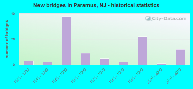
- New bridges - historical statistics
- 31930-1939
- 21940-1949
- 381950-1959
- 91960-1969
- 51970-1979
- 21980-1989
- 221990-1999
- 12000-2009
- 122010-2019
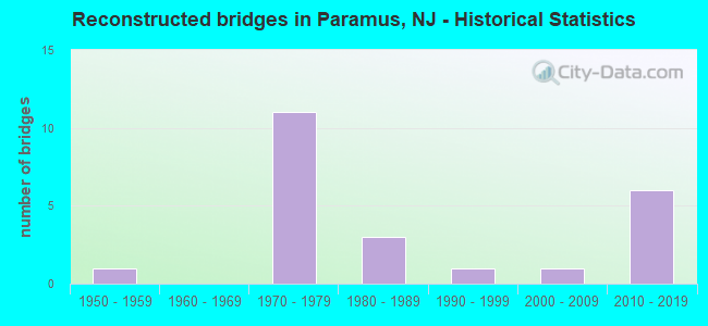
- Reconstructed bridges - Historical Statistics
- 11950-1959
- 01960-1969
- 111970-1979
- 31980-1989
- 11990-1999
- 12000-2009
- 62010-2019
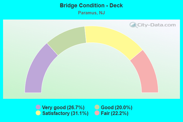
- Bridge Condition - Deck
- 26.7%Very good
- 20.0%Good
- 31.1%Satisfactory
- 22.2%Fair
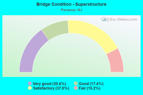
- Bridge Condition - Superstructure
- 30.4%Very good
- 17.4%Good
- 37.0%Satisfactory
- 15.2%Fair
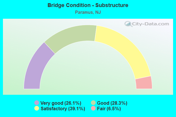
- Bridge Condition - Substructure
- 26.1%Very good
- 28.3%Good
- 39.1%Satisfactory
- 6.5%Fair
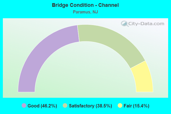
- Bridge Condition - Channel
- 46.2%Good
- 38.5%Satisfactory
- 15.4%Fair
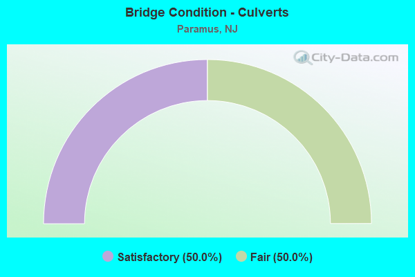
- Bridge Condition - Culverts
- 50.0%Satisfactory
- 50.0%Fair
Find on map >> Show street view
Structure Number: 20046A, Location: 1.143 mi E of CR 507 (Lat: 40.980589, Lng: -74.091031), Route carried "on" structure: County highway 110I, Year Built: 1945, Year Reconstructed: 1995, Status: Open, Structure Length: 2.23m (7.32ft), Average Daily Traffic: 19,450 (year 2020), Truck Traffic: 4%, Average Future Daily Traffic: 23,340 (year 2040), Design Load: HS 20, Features Intersected: SADDLE RIVER
Minimum Vertical Clearance: 30+ m (98+ ft), Kilometerpoint: 1.839, Lanes on structure: 2, Owner: County Highway Agency, Approaching Roadway Width: 11.6m (38.1ft), Skew: 1 degrees, Material/Design: Steel, Design/Construction: Stringer/Multi-beam, Number Of Spans In Main Unit: 2, Length of Maximum Span: 10.7m (35.1ft), Curb or Sidewalk Widths: Left: 2.3m (7.5ft), Right: 2.3m (7.5ft), Curb-To-Curb Width: 9.1m (29.9ft), Out-to-Out Width: 14.6m (47.9ft)
Condition: Deck: Satisfactory, Superstructure: Satisfactory, Substructure: Fair, Channel: Fair, Inventory Rating: 54.4 metric tons, Method Used To Determine Inventory Rating: Load Factor (LF), Structural Evaluation: Somewhat better than minimum adequacy, Deck Geometry: High priority of corrective action, Waterway Adequacy: Equal to present desirable criteria, Approach Roadway Alignment: Equal to present desirable criteria, Length Of Structure Improvement: 2.23m (7.32ft), Designated Inspection Frequency: Every 24 months, Underwater Inspection Frequency: Every 24 months, Inspection Date: April 2020, Underwater Inspection Date: April 2020, Bridge Improvement Cost: $82,000, Roadway Improvement Cost: $124,000, Total Project Cost: $751,000 ( Estimate for 2020), Deck Structure Type: Concrete Cast-file-Place, Wearing Surface/Protective System: Wearing Surface: Monolithic Concrete
Find on map >> Show street view
Structure Number: 20046B, Location: 0.193 mi West of NJ 17 (Lat: 40.930161, Lng: -74.073181), Route carried "on" structure: City street , Year Built: 1944, Status: Posted for load, Structure Length: 1.10m (3.61ft), Average Daily Traffic: 21,540 (year 2020), Truck Traffic: 4%, Average Future Daily Traffic: 25,850 (year 2040), Features Intersected: SPROUT BROOK, Facility Carried by Structure: CENTURY ROAD
Minimum Vertical Clearance: 30+ m (98+ ft), Kilometerpoint: 2.039, Lanes on structure: 2, Owner: County Highway Agency, Approaching Roadway Width: 12.2m (40.0ft), Skew: 1 degrees, Material/Design: Steel, Design/Construction: Stringer/Multi-beam, Number Of Spans In Main Unit: 1, Length of Maximum Span: 10.4m (34.1ft), Curb-To-Curb Width: 11.2m (36.7ft), Out-to-Out Width: 12.1m (39.7ft)
Condition: Deck: Satisfactory, Superstructure: Fair, Substructure: Good, Channel: Good, Operating Rating: 26.3 metric tons, Method Used To Determine Operating Rating: Load Factor (LF), Inventory Rating: 15.4 metric tons, Method Used To Determine Inventory Rating: Load Factor (LF), Structural Evaluation: High priority of corrective action, Deck Geometry: Meets minimum limits, Waterway Adequacy: Superior to present desirable criteria, Approach Roadway Alignment: Better than present minimum criteria, Bridge Posting: Required (Relationship of Operating Rating to Maximum Legal Load: 0.1 - 9.9% below), Length Of Structure Improvement: 1.77m (5.81ft), Designated Inspection Frequency: Every 24 months, Other Special Inspection Frequency: Every 12 months, Inspection Date: April 2020, Other Special Inspection Date: July 2021, Total Project Cost: $264,000 ( Estimate for 2020), Deck Structure Type: Concrete Cast-file-Place, Wearing Surface/Protective System: Wearing Surface: Bituminous
Find on map >> Show street view
Structure Number: 20046C, Location: 0.02 mi W. of Paramus Rd. (Lat: 40.947689, Lng: -74.093911), Route carried "on" structure: County highway S76, Year Built: 1960, Status: Open, Structure Length: 0.85m (2.79ft), Average Daily Traffic: 541 (year 2020), Truck Traffic: 1%, Average Future Daily Traffic: 650 (year 2040), Features Intersected: Trib. of Saddle River, Facility Carried by Structure: Dunkerhook Road
Minimum Vertical Clearance: 30+ m (98+ ft), Kilometerpoint: 0.048, Lanes on structure: 2, Owner: County Highway Agency, Approaching Roadway Width: 6.7m (22.0ft), Material/Design: Steel, Design/Construction: Culvert, Number Of Spans In Main Unit: 4, Length of Maximum Span: 1.5m (4.9ft), Curb-To-Curb Width: 6.7m (22.0ft), Out-to-Out Width: 9.1m (29.9ft)
Condition: Channel: Fair, Culverts: Fair, Structural Evaluation: Somewhat better than minimum adequacy, Deck Geometry: Meets minimum limits, Waterway Adequacy: Better than present minimum criteria, Approach Roadway Alignment: Meets minimum limits, Designated Inspection Frequency: Every 24 months, Inspection Date: May 2020
Find on map >> Show street view
Structure Number: 20046D, Location: 0.83 MI W CR 503 (Lat: 40.922381, Lng: -74.049431), Route carried "on" structure: City street , Year Built: 2005, Status: Open, Structure Length: 0.98m (3.22ft), Average Daily Traffic: 14,114 (year 2020), Truck Traffic: 4%, Average Future Daily Traffic: 16,937 (year 2040), Design Load: HS 25 or greater, Features Intersected: VAN SAUN MILL BROOK, Facility Carried by Structure: HOWLAND AVENUE
Minimum Vertical Clearance: 30+ m (98+ ft), Kilometerpoint: 0.853, Lanes on structure: 2, Owner: County Highway Agency, Approaching Roadway Width: 10.1m (33.1ft), Material/Design: Prestressed concrete, Design/Construction: Arch - Deck, Number Of Spans In Main Unit: 1, Length of Maximum Span: 9.8m (32.2ft), Curb or Sidewalk Widths: Left: 1.6m (5.2ft), Right: 1.6m (5.2ft), Curb-To-Curb Width: 10.1m (33.1ft), Out-to-Out Width: 13.9m (45.6ft)
Condition: Superstructure: Good, Substructure: Very good, Channel: Satisfactory, Operating Rating: 41.7 metric tons, Method Used To Determine Operating Rating: Field evaluation and documented engineering judgment, Inventory Rating: 32.7 metric tons, Method Used To Determine Inventory Rating: Field evaluation and documented engineering judgment, Structural Evaluation: Better than present minimum criteria, Deck Geometry: Meets minimum limits, Waterway Adequacy: Superior to present desirable criteria, Approach Roadway Alignment: Equal to present desirable criteria, Designated Inspection Frequency: Every 24 months, Inspection Date: March 2020
Find on map >> Show street view
Structure Number: 20046E, Location: 0.08 MI W OF CR 62 (Lat: 40.962431, Lng: -74.094250), Route carried "on" structure: City street , Year Built: 1977, Status: Open, Structure Length: 3.57m (11.71ft), Average Daily Traffic: 17,160 (year 2020), Truck Traffic: 4%, Average Future Daily Traffic: 20,590 (year 2040), Design Load: HS 20, Features Intersected: SADDLE RIVER, Facility Carried by Structure: GROVE ST
Minimum Vertical Clearance: 30+ m (98+ ft), Kilometerpoint: 1.849, Lanes on structure: 4, Owner: County Highway Agency, Approaching Roadway Width: 17.4m (57.1ft), Skew: 21 degrees, Material/Design: Prestressed concrete, Design/Construction: Box Beam or Girders - Multiple, Number Of Spans In Main Unit: 2, Length of Maximum Span: 17.1m (56.1ft), Curb or Sidewalk Widths: Left: 1.8m (5.9ft), Right: 1.8m (5.9ft), Curb-To-Curb Width: 15.8m (51.8ft), Out-to-Out Width: 21.6m (70.9ft)
Condition: Deck: Fair, Superstructure: Fair, Substructure: Good, Channel: Good, Operating Rating: 49.0 metric tons, Method Used To Determine Operating Rating: Load Factor (LF), Inventory Rating: 29.0 metric tons, Method Used To Determine Inventory Rating: Load Factor (LF), Structural Evaluation: Somewhat better than minimum adequacy, Deck Geometry: Meets minimum limits, Waterway Adequacy: Equal to present desirable criteria, Approach Roadway Alignment: Better than present minimum criteria, Designated Inspection Frequency: Every 24 months, Inspection Date: April 2020, Deck Structure Type: Concrete Precast Panels, Wearing Surface/Protective System: Wearing Surface: Bituminous
Find on map >> Show street view
Structure Number: 20046F, Location: 0.128 Mi W. of CR 62 (Lat: 40.972711, Lng: -74.092639), Route carried "on" structure: County highway 80I, Year Built: 1976, Status: Open, Structure Length: 2.71m (8.89ft), Average Daily Traffic: 12,690 (year 2020), Truck Traffic: 4%, Average Future Daily Traffic: 15,230 (year 2040), Design Load: HS 20, Features Intersected: SADDLE RIVER
Minimum Vertical Clearance: 30+ m (98+ ft), Kilometerpoint: 4.719, Lanes on structure: 2, Base Highway Network: Yes, Owner: County Highway Agency, Approaching Roadway Width: 14.0m (45.9ft), Material/Design: Steel, Design/Construction: Stringer/Multi-beam, Number Of Spans In Main Unit: 1, Length of Maximum Span: 25.9m (85.0ft), Curb or Sidewalk Widths: Left: 2.1m (6.9ft), Right: 2.1m (6.9ft), Curb-To-Curb Width: 14.0m (45.9ft), Out-to-Out Width: 18.8m (61.7ft)
Condition: Deck: Fair, Superstructure: Fair, Substructure: Satisfactory, Channel: Good, Operating Rating: 83.5 metric tons, Method Used To Determine Operating Rating: Load Factor (LF), Inventory Rating: 49.9 metric tons, Method Used To Determine Inventory Rating: Load Factor (LF), Structural Evaluation: Somewhat better than minimum adequacy, Deck Geometry: Superior to present desirable criteria, Waterway Adequacy: Superior to present desirable criteria, Approach Roadway Alignment: Equal to present desirable criteria, Designated Inspection Frequency: Every 24 months, Inspection Date: April 2020, Deck Structure Type: Concrete Cast-file-Place, Wearing Surface/Protective System: Wearing Surface: Monolithic Concrete
Find on map >> Show street view
Structure Number: 20046G, Location: 0.03 mi W. of GS Parkway (Lat: 40.948231, Lng: -74.067311), Route carried "on" structure: City street , Year Built: 1971, Status: Open, Structure Length: 1.22m (4.00ft), Average Daily Traffic: 35,980 (year 2020), Truck Traffic: 4%, Average Future Daily Traffic: 42,170 (year 2040), Design Load: HS 20+Mod, Features Intersected: SPROUT BROOK, Facility Carried by Structure: MIDLAND AVE
Minimum Vertical Clearance: 30+ m (98+ ft), Kilometerpoint: 4.709, Lanes on structure: 4, Owner: County Highway Agency, Approaching Roadway Width: 14.0m (45.9ft), Skew: 3 degrees, Material/Design: Prestressed concrete, Design/Construction: Slab, Number Of Spans In Main Unit: 1, Length of Maximum Span: 11.9m (39.0ft), Curb or Sidewalk Widths: Left: 1.8m (5.9ft), Right: 1.8m (5.9ft), Curb-To-Curb Width: 14.0m (45.9ft), Out-to-Out Width: 18.3m (60.0ft)
Condition: Deck: Fair, Superstructure: Fair, Substructure: Satisfactory, Channel: Satisfactory, Operating Rating: 40.8 metric tons, Method Used To Determine Operating Rating: Load Factor (LF), Inventory Rating: 24.5 metric tons, Method Used To Determine Inventory Rating: Load Factor (LF), Structural Evaluation: Somewhat better than minimum adequacy, Deck Geometry: High priority of replacement, Waterway Adequacy: Superior to present desirable criteria, Approach Roadway Alignment: Equal to present desirable criteria, Length Of Structure Improvement: 1.25m (4.10ft), Designated Inspection Frequency: Every 24 months, Inspection Date: April 2020, Bridge Improvement Cost: $26,000, Roadway Improvement Cost: $100,000, Total Project Cost: $188,000 ( Estimate for 2020), Deck Structure Type: Concrete Precast Panels, Wearing Surface/Protective System: Wearing Surface: Bituminous, Membrane: Epoxy
Find on map >> Show street view
Structure Number: 20046H, Location: 0.827 mi North of NJ 4 (Lat: 40.927831, Lng: -74.051219), Route carried "on" structure: County highway 59, Year Built: 1968, Status: Open, Structure Length: 0.82m (2.69ft), Average Daily Traffic: 22,690 (year 2020), Truck Traffic: 4%, Average Future Daily Traffic: 27,230 (year 2040), Design Load: HS 20, Features Intersected: HERRING BROOK
Minimum Vertical Clearance: 30+ m (98+ ft), Kilometerpoint: 4.550, Lanes on structure: 4, Base Highway Network: Yes, Owner: County Highway Agency, Approaching Roadway Width: 14.1m (46.3ft), Skew: 1 degrees, Material/Design: Concrete, Design/Construction: Culvert, Number Of Spans In Main Unit: 2, Length of Maximum Span: 4.0m (13.1ft), Curb or Sidewalk Widths: Left: 2.3m (7.5ft), Right: 2.4m (7.9ft), Curb-To-Curb Width: 14.1m (46.3ft), Out-to-Out Width: 19.5m (64.0ft)
Condition: Channel: Satisfactory, Culverts: Satisfactory, Operating Rating: 46.3 metric tons, Method Used To Determine Operating Rating: Load Factor (LF), Inventory Rating: 28.1 metric tons, Method Used To Determine Inventory Rating: Load Factor (LF), Structural Evaluation: Equal to present minimum criteria, Deck Geometry: High priority of replacement, Waterway Adequacy: Superior to present desirable criteria, Approach Roadway Alignment: Equal to present desirable criteria, Length Of Structure Improvement: 0.82m (2.69ft), Designated Inspection Frequency: Every 24 months, Inspection Date: April 2020, Bridge Improvement Cost: $150,000, Roadway Improvement Cost: $106,000, Total Project Cost: $381,000 ( Estimate for 2020)
Find on map >> Show street view
Structure Number: 206152, Location: 0.2 MI EAST OF SADDLE RIV (Lat: 40.925611, Lng: -74.089461), Route carried "on" structure: County highway 62, Year Built: 1956, Status: Open, Structure Length: 4.69m (15.39ft), Average Daily Traffic: 32,410 (year 2020), Truck Traffic: 4%, Average Future Daily Traffic: 38,892 (year 2040), Design Load: HS 20, Features Intersected: NJ 4
Minimum Vertical Clearance: 30+ m (98+ ft), Kilometerpoint: 5.955, Lanes on structure: 4, Lanes under structure: 9, Owner: State Highway Agency, Approaching Roadway Width: 13.4m (44.0ft), Skew: 2 degrees, Material/Design: Steel, Design/Construction: Stringer/Multi-beam, Number Of Spans In Main Unit: 2, Length of Maximum Span: 24.7m (81.0ft), Curb or Sidewalk Widths: Left: 1.8m (5.9ft), Right: 1.8m (5.9ft), Curb-To-Curb Width: 13.4m (44.0ft), Out-to-Out Width: 17.7m (58.1ft)
Condition: Deck: Good, Superstructure: Good, Substructure: Good, Operating Rating: 86.2 metric tons, Method Used To Determine Operating Rating: Load Factor (LF), Inventory Rating: 51.7 metric tons, Method Used To Determine Inventory Rating: Load Factor (LF), Structural Evaluation: Better than present minimum criteria, Deck Geometry: High priority of replacement, Underclear: High priority of corrective action, Approach Roadway Alignment: Better than present minimum criteria, Length Of Structure Improvement: 4.69m (15.39ft), Designated Inspection Frequency: Every 24 months, Inspection Date: May 2020, Bridge Improvement Cost: $2,091,000, Roadway Improvement Cost: $209,000, Total Project Cost: $2,645,000 ( Estimate for 2018), Deck Structure Type: Concrete Precast Panels
Find on map >> Show street view
Structure Number: 206153, Location: 0.2 MI WEST OF NJ 17 (Lat: 40.921439, Lng: -74.075981), Route carried "on" structure: State highway 4, Year Built: 1999, Status: Open, Structure Length: 1.65m (5.41ft), Average Daily Traffic: 117,756 (year 2020), Truck Traffic: 5%, Average Future Daily Traffic: 143,662 (year 2040), Design Load: HS 25 or greater, Features Intersected: SPROUT BROOK
Minimum Vertical Clearance: 30.45m (99.90ft), Kilometerpoint: 5.069, Lanes on structure: 11, Base Highway Network: Yes, Owner: State Highway Agency, Approaching Roadway Width: 53.6m (175.9ft), Skew: 32 degrees, Material/Design: Prestressed concrete, Design/Construction: Stringer/Multi-beam, Number Of Spans In Main Unit: 1, Length of Maximum Span: 14.9m (48.9ft), Curb or Sidewalk Widths: Left: 1.8m (5.9ft), Right: 1.8m (5.9ft), Curb-To-Curb Width: 53.6m (175.9ft), Out-to-Out Width: 63.6m (208.7ft)
Condition: Deck: Good, Superstructure: Very good, Substructure: Good, Channel: Good, Operating Rating: 70.8 metric tons, Method Used To Determine Operating Rating: Load Factor (LF), Inventory Rating: 42.6 metric tons, Method Used To Determine Inventory Rating: Load Factor (LF), Structural Evaluation: Better than present minimum criteria, Deck Geometry: Superior to present desirable criteria, Waterway Adequacy: Superior to present desirable criteria, Approach Roadway Alignment: Equal to present desirable criteria, Designated Inspection Frequency: Every 24 months, Inspection Date: March 2020, Deck Structure Type: Concrete Cast-file-Place, Wearing Surface/Protective System: Wearing Surface: Integral Concrete, Deck Protection: Epoxy Coated Reinforcing
Find on map >> Show street view
Structure Number: 206154, Location: 0.2 MI EAST OF RT 17 (Lat: 40.919700, Lng: -74.068781), Route carried "on" structure: County highway 61, Year Built: 1999, Status: Open, Structure Length: 4.51m (14.80ft), Average Daily Traffic: 15,972 (year 2020), Truck Traffic: 4%, Average Future Daily Traffic: 19,166 (year 2040), Design Load: HS 25 or greater, Features Intersected: NJ 4
Minimum Vertical Clearance: 30+ m (98+ ft), Kilometerpoint: 8.015, Lanes on structure: 3, Lanes under structure: 9, Owner: State Highway Agency, Approaching Roadway Width: 15.2m (49.9ft), Material/Design: Steel continuous, Design/Construction: Stringer/Multi-beam, Number Of Spans In Main Unit: 2, Length of Maximum Span: 21.6m (70.9ft), Curb or Sidewalk Widths: Left: 2.1m (6.9ft), Right: 2.1m (6.9ft), Curb-To-Curb Width: 15.2m (49.9ft), Out-to-Out Width: 20.1m (65.9ft)
Condition: Deck: Good, Superstructure: Good, Substructure: Satisfactory, Structural Evaluation: Equal to present minimum criteria, Deck Geometry: Equal to present minimum criteria, Underclear: Better than present minimum criteria, Approach Roadway Alignment: Equal to present desirable criteria, Designated Inspection Frequency: Every 24 months, Inspection Date: May 2020, Deck Structure Type: Concrete Cast-file-Place, Wearing Surface/Protective System: Wearing Surface: Monolithic Concrete, Deck Protection: Epoxy Coated Reinforcing
Find on map >> Show street view
Structure Number: 206155, Location: 0.5 MI. EAST OF NJ 17 (Lat: 40.917811, Lng: -74.061411), Route carried "on" structure: City street , Year Built: 1958, Status: Open, Structure Length: 3.05m (10.01ft), Average Daily Traffic: 13,196 (year 2020), Truck Traffic: 4%, Average Future Daily Traffic: 15,835 (year 2040), Design Load: H 20, Features Intersected: NJ 4, Facility Carried by Structure: SPRING VALLEY RD
Minimum Vertical Clearance: 30+ m (98+ ft), Kilometerpoint: 1.465, Lanes on structure: 2, Lanes under structure: 7, Owner: State Highway Agency, Approaching Roadway Width: 11.0m (36.1ft), Material/Design: Steel, Design/Construction: Stringer/Multi-beam, Number Of Spans In Main Unit: 1, Length of Maximum Span: 28.7m (94.2ft), Curb or Sidewalk Widths: Left: 1.8m (5.9ft), Right: 1.3m (4.3ft), Curb-To-Curb Width: 11.0m (36.1ft), Out-to-Out Width: 15.4m (50.5ft)
Condition: Deck: Fair, Superstructure: Satisfactory, Substructure: Satisfactory, Operating Rating: 80.7 metric tons, Method Used To Determine Operating Rating: Load Factor (LF), Inventory Rating: 48.1 metric tons, Method Used To Determine Inventory Rating: Load Factor (LF), Structural Evaluation: Equal to present minimum criteria, Deck Geometry: Meets minimum limits, Underclear: Meets minimum limits, Approach Roadway Alignment: Somewhat better than minimum adequacy, Designated Inspection Frequency: Every 24 months, Inspection Date: March 2020, Deck Structure Type: Concrete Cast-file-Place, Wearing Surface/Protective System: Wearing Surface: Monolithic Concrete
Find on map >> Show street view
Structure Number: 206159, Location: 1.0 MI EAST NJ 17 (Lat: 40.915919, Lng: -74.054819), Route carried "on" structure: County highway 59, Year Built: 1937, Year Reconstructed: 1957, Status: Open, Structure Length: 4.30m (14.11ft), Average Daily Traffic: 16,469 (year 2020), Truck Traffic: 4%, Average Future Daily Traffic: 19,763 (year 2040), Design Load: HS 20, Features Intersected: NJ 4
Minimum Vertical Clearance: 30+ m (98+ ft), Kilometerpoint: 3.219, Lanes on structure: 4, Lanes under structure: 7, Owner: State Highway Agency, Approaching Roadway Width: 14.6m (47.9ft), Skew: 20 degrees, Material/Design: Steel, Design/Construction: Stringer/Multi-beam, Number Of Spans In Main Unit: 3, Length of Maximum Span: 15.8m (51.8ft), Curb or Sidewalk Widths: Left: 1.5m (4.9ft), Right: 0.5m (1.6ft), Curb-To-Curb Width: 14.6m (47.9ft), Out-to-Out Width: 17.8m (58.4ft)
Condition: Deck: Fair, Superstructure: Fair, Substructure: Fair, Operating Rating: 35.4 metric tons, Method Used To Determine Operating Rating: Load Factor (LF), Inventory Rating: 20.9 metric tons, Method Used To Determine Inventory Rating: Load Factor (LF), Structural Evaluation: Somewhat better than minimum adequacy, Deck Geometry: High priority of replacement, Underclear: High priority of replacement, Approach Roadway Alignment: Equal to present desirable criteria, Length Of Structure Improvement: 5.18m (16.99ft), Designated Inspection Frequency: Every 24 months, Inspection Date: March 2020, Bridge Improvement Cost: $5,545,000, Roadway Improvement Cost: $554,000, Total Project Cost: $8,612,000 ( Estimate for 2020), Deck Structure Type: Concrete Cast-file-Place, Wearing Surface/Protective System: Wearing Surface: Bituminous
Find on map >> Show street view
Structure Number: 20619, Location: 0.04 MI E OF NJ4&NJ17 JCT (Lat: 40.919569, Lng: -74.072069), Route carried "on" structure: Ramp State highway 4, Year Built: 1999, Status: Open, Structure Length: 26.55m (87.11ft), Average Daily Traffic: 14,291 (year 2021), Truck Traffic: 5%, Average Future Daily Traffic: 17,437 (year 2041), Design Load: HS 25 or greater, Features Intersected: NJ 4, NJ 17 & RAMP
Minimum Vertical Clearance: 30+ m (98+ ft), Kilometerpoint: 5.375, Lanes on structure: 1, Lanes under structure: 14, Owner: State Highway Agency, Approaching Roadway Width: 7.9m (25.9ft), Skew: 9 degrees, Material/Design: Steel continuous, Design/Construction: Stringer/Multi-beam, Number Of Spans In Main Unit: 7, Length of Maximum Span: 51.2m (168.0ft), Curb-To-Curb Width: 8.0m (26.2ft), Out-to-Out Width: 9.1m (29.9ft)
Condition: Deck: Good, Superstructure: Very good, Substructure: Good, Inventory Rating: 79.8 metric tons, Method Used To Determine Inventory Rating: Load Factor (LF), Structural Evaluation: Better than present minimum criteria, Deck Geometry: Superior to present desirable criteria, Underclear: High priority of corrective action, Approach Roadway Alignment: Equal to present desirable criteria, Designated Inspection Frequency: Every 24 months, Inspection Date: March 2021, Deck Structure Type: Concrete Cast-file-Place, Wearing Surface/Protective System: Wearing Surface: Monolithic Concrete, Deck Protection: Epoxy Coated Reinforcing
Find on map >> Show street view
Structure Number: 206192, Location: 0.15 MI EAST OF GSP (Lat: 40.921800, Lng: -74.077731), Route carried "on" structure: City street , Year Built: 1999, Status: Open, Structure Length: 8.05m (26.41ft), Average Daily Traffic: 6,376 (year 2020), Truck Traffic: 1%, Average Future Daily Traffic: 7,768 (year 2040), Features Intersected: NJ 4 & C-D RAMPS, Facility Carried by Structure: IKEA DRIVE
Minimum Vertical Clearance: 30.45m (99.90ft), Kilometerpoint: 0.000, Lanes on structure: 4, Lanes under structure: 11, Owner: State Highway Agency, Approaching Roadway Width: 13.4m (44.0ft), Skew: 2 degrees, Material/Design: Steel continuous, Design/Construction: Stringer/Multi-beam, Number Of Spans In Main Unit: 2, Length of Maximum Span: 39.3m (128.9ft), Curb or Sidewalk Widths: Left: 0.0m, Right: 1.8m (5.9ft), Curb-To-Curb Width: 13.5m (44.3ft), Out-to-Out Width: 16.2m (53.1ft)
Condition: Deck: Good, Superstructure: Good, Substructure: Good, Inventory Rating: 68.0 metric tons, Method Used To Determine Inventory Rating: Load Factor (LF), Structural Evaluation: Better than present minimum criteria, Deck Geometry: High priority of replacement, Underclear: High priority of corrective action, Approach Roadway Alignment: Equal to present minimum criteria, Length Of Structure Improvement: 8.05m (26.41ft), Designated Inspection Frequency: Every 24 months, Inspection Date: April 2020, Bridge Improvement Cost: $1,000, Total Project Cost: $1,000 ( Estimate for 2020), Deck Structure Type: Concrete Cast-file-Place, Wearing Surface/Protective System: Wearing Surface: Monolithic Concrete, Deck Protection: Epoxy Coated Reinforcing
Find on map >> Show street view
Structure Number: 206193, Location: ROUTES 4 AND 17 INTERCHNG (Lat: 40.922139, Lng: -74.072861), Route carried "on" structure: Ramp State highway 4, Year Built: 1999, Status: Open, Structure Length: 31.85m (104.49ft), Average Daily Traffic: 10,570 (year 2020), Truck Traffic: 5%, Average Future Daily Traffic: 12,900 (year 2040), Design Load: HS 25 or greater, Features Intersected: NJ RT.4,RT 17 AND RAMPS
Minimum Vertical Clearance: 30+ m (98+ ft), Kilometerpoint: 5.375, Lanes on structure: 1, Lanes under structure: 19, Owner: State Highway Agency, Approaching Roadway Width: 7.9m (25.9ft), Material/Design: Steel continuous, Design/Construction: Stringer/Multi-beam, Number Of Spans In Main Unit: 9, Length of Maximum Span: 42.7m (140.1ft), Curb-To-Curb Width: 8.0m (26.2ft), Out-to-Out Width: 9.0m (29.5ft)
Condition: Deck: Good, Superstructure: Very good, Substructure: Very good, Operating Rating: 60.8 metric tons, Method Used To Determine Operating Rating: Load Factor (LF), Inventory Rating: 36.3 metric tons, Method Used To Determine Inventory Rating: Load Factor (LF), Structural Evaluation: Equal to present desirable criteria, Deck Geometry: Superior to present desirable criteria, Underclear: High priority of corrective action, Approach Roadway Alignment: Equal to present minimum criteria, Designated Inspection Frequency: Every 24 months, Inspection Date: July 2020, Deck Structure Type: Concrete Cast-file-Place, Wearing Surface/Protective System: Wearing Surface: Monolithic Concrete, Deck Protection: Epoxy Coated Reinforcing
Find on map >> Show street view
Structure Number: 214162, Location: 0.5 MILES SOUTH OF NJ 4 (Lat: 40.912950, Lng: -74.071600), Route carried "on" structure: County highway 61, Year Built: 1994, Status: Open, Structure Length: 7.16m (23.49ft), Average Daily Traffic: 16,691 (year 2020), Truck Traffic: 4%, Average Future Daily Traffic: 20,363 (year 2040), Design Load: HS 25 or greater, Features Intersected: NJ 17
Minimum Vertical Clearance: 30.45m (99.90ft), Kilometerpoint: 7.226, Lanes on structure: 4, Lanes under structure: 5, Owner: State Highway Agency, Approaching Roadway Width: 9.1m (29.9ft), Skew: 4 degrees, Material/Design: Steel continuous, Design/Construction: Stringer/Multi-beam, Number Of Spans In Main Unit: 2, Length of Maximum Span: 37.5m (123.0ft), Curb or Sidewalk Widths: Left: 1.8m (5.9ft), Right: 0.0m, Curb-To-Curb Width: 15.2m (49.9ft), Out-to-Out Width: 17.9m (58.7ft)
Condition: Deck: Satisfactory, Superstructure: Good, Substructure: Satisfactory, Inventory Rating: 59.9 metric tons, Method Used To Determine Inventory Rating: Load Factor (LF), Structural Evaluation: Equal to present minimum criteria, Deck Geometry: High priority of corrective action, Underclear: High priority of corrective action, Approach Roadway Alignment: Equal to present desirable criteria, Length Of Structure Improvement: 7.16m (23.49ft), Designated Inspection Frequency: Every 24 months, Inspection Date: March 2020, Deck Structure Type: Concrete Cast-file-Place, Wearing Surface/Protective System: Wearing Surface: Monolithic Concrete, Deck Protection: Epoxy Coated Reinforcing
Find on map >> Show street view
Structure Number: 21515, Location: INTERSECTION RT 4 (Lat: 40.920500, Lng: -74.072119), Route carried "on" structure: State highway 17, Year Built: 1999, Status: Open, Structure Length: 6.22m (20.41ft), Average Daily Traffic: 116,839 (year 2022), Truck Traffic: 4%, Average Future Daily Traffic: 140,207 (year 2042), Design Load: HS 20, Features Intersected: ROUTE NJ 4
Minimum Vertical Clearance: 5.07m (16.63ft), Kilometerpoint: 19.843, Lanes on structure: 8, Lanes under structure: 9, Base Highway Network: Yes, Owner: State Highway Agency, Approaching Roadway Width: 33.6m (110.2ft), Skew: 10 degrees, Material/Design: Steel continuous, Design/Construction: Stringer/Multi-beam, Number Of Spans In Main Unit: 2, Length of Maximum Span: 34.1m (111.9ft), Curb-To-Curb Width: 33.6m (110.2ft), Out-to-Out Width: 37.2m (122.0ft)
Condition: Deck: Good, Superstructure: Good, Substructure: Satisfactory, Inventory Rating: 85.3 metric tons, Method Used To Determine Inventory Rating: Load Factor (LF), Structural Evaluation: Equal to present minimum criteria, Deck Geometry: Meets minimum limits, Underclear: High priority of corrective action, Approach Roadway Alignment: Equal to present desirable criteria, Designated Inspection Frequency: Every 24 months, Inspection Date: Febuary 2020, Deck Structure Type: Concrete Cast-file-Place, Wearing Surface/Protective System: Wearing Surface: Latex Concrete, Deck Protection: Epoxy Coated Reinforcing
Find on map >> Show street view
Structure Number: 215151, Location: 0.55 MILE NORTH O F NJ 4 (Lat: 40.928469, Lng: -74.070839), Route carried "on" structure: City street , Year Built: 1959, Year Reconstructed: 2010, Status: Open, Structure Length: 4.05m (13.29ft), Average Daily Traffic: 21,444 (year 2020), Truck Traffic: 4%, Average Future Daily Traffic: 26,162 (year 2040), Design Load: HL 93, Features Intersected: NJ 17, Facility Carried by Structure: CENTURY ROAD
Minimum Vertical Clearance: 30.45m (99.90ft), Kilometerpoint: 2.350, Lanes on structure: 3, Lanes under structure: 8, Owner: State Highway Agency, Approaching Roadway Width: 11.0m (36.1ft), Material/Design: Steel, Design/Construction: Stringer/Multi-beam, Number Of Spans In Main Unit: 2, Length of Maximum Span: 19.5m (64.0ft), Curb or Sidewalk Widths: Left: 1.8m (5.9ft), Right: 1.5m (4.9ft), Curb-To-Curb Width: 11.0m (36.1ft), Out-to-Out Width: 15.2m (49.9ft)
Condition: Deck: Good, Superstructure: Good, Substructure: Satisfactory, Operating Rating: 72.6 metric tons, Method Used To Determine Operating Rating: Load and Resistance Factor Rating (LRFR) rating reported by rating factor(RF) method using HL-93 loadings, Inventory Rating: 69.0 metric tons, Method Used To Determine Inventory Rating: Load and Resistance Factor Rating (LRFR) rating reported by rating factor(RF) method using HL-93 loadings, Structural Evaluation: Equal to present minimum criteria, Deck Geometry: High priority of replacement, Underclear: High priority of corrective action, Approach Roadway Alignment: Equal to present minimum criteria, Length Of Structure Improvement: 4.05m (13.29ft), Designated Inspection Frequency: Every 24 months, Inspection Date: April 2020, Bridge Improvement Cost: $1,000, Total Project Cost: $2,000 ( Estimate for 2020), Deck Structure Type: Concrete Cast-file-Place, Wearing Surface/Protective System: Deck Protection: Epoxy Coated Reinforcing
Find on map >> Show street view
Structure Number: 21615, Location: 0.3 MI N OF GSP EXIT 163 (Lat: 40.944411, Lng: -74.071589), Route carried "on" structure: State highway 17, Year Built: 1933, Year Reconstructed: 1970, Status: Open, Structure Length: 1.43m (4.69ft), Average Daily Traffic: 142,900 (year 2021), Truck Traffic: 5%, Average Future Daily Traffic: 171,500 (year 2041), Design Load: HS 20+Mod, Features Intersected: SPROUT BROOK
Minimum Vertical Clearance: 30+ m (98+ ft), Kilometerpoint: 22.499, Lanes on structure: 6, Base Highway Network: Yes, Owner: State Highway Agency, Approaching Roadway Width: 32.3m (106.0ft), Skew: 34 degrees, Material/Design: Steel, Design/Construction: Stringer/Multi-beam, Number Of Spans In Main Unit: 1, Length of Maximum Span: 13.7m (44.9ft), Curb or Sidewalk Widths: Left: 1.2m (3.9ft), Right: 1.2m (3.9ft), Curb-To-Curb Width: 32.3m (106.0ft), Out-to-Out Width: 36.1m (118.4ft)
Condition: Deck: Satisfactory, Superstructure: Satisfactory, Substructure: Satisfactory, Channel: Satisfactory, Operating Rating: 53.5 metric tons, Method Used To Determine Operating Rating: Load Factor (LF), Inventory Rating: 31.8 metric tons, Method Used To Determine Inventory Rating: Load Factor (LF), Structural Evaluation: Equal to present minimum criteria, Deck Geometry: Superior to present desirable criteria, Waterway Adequacy: Superior to present desirable criteria, Approach Roadway Alignment: Equal to present desirable criteria, Length Of Structure Improvement: 1.43m (4.69ft), Designated Inspection Frequency: Every 24 months, Inspection Date: August 2021, Bridge Improvement Cost: $334,000, Total Project Cost: $400,000 ( Estimate for 2021), Deck Structure Type: Concrete Cast-file-Place, Wearing Surface/Protective System: Wearing Surface: Bituminous
Find on map >> Show street view
Structure Number: 216152, Location: 0.67 MI NORTH OF GSP (Lat: 40.949600, Lng: -74.072481), Route carried "on" structure: City street , Year Built: 1959, Year Reconstructed: 2010, Status: Open, Structure Length: 5.39m (17.68ft), Average Daily Traffic: 27,475 (year 2020), Truck Traffic: 4%, Average Future Daily Traffic: 33,520 (year 2040), Features Intersected: NJ 17, Facility Carried by Structure: MIDLAND AVENUE
Minimum Vertical Clearance: 30.45m (99.90ft), Kilometerpoint: 4.233, Lanes on structure: 3, Lanes under structure: 8, Owner: State Highway Agency, Approaching Roadway Width: 11.3m (37.1ft), Skew: 4 degrees, Material/Design: Steel, Design/Construction: Stringer/Multi-beam, Number Of Spans In Main Unit: 2, Length of Maximum Span: 26.2m (86.0ft), Curb or Sidewalk Widths: Left: 1.5m (4.9ft), Right: 1.6m (5.2ft), Curb-To-Curb Width: 11.3m (37.1ft), Out-to-Out Width: 15.3m (50.2ft)
Condition: Deck: Good, Superstructure: Satisfactory, Substructure: Fair, Inventory Rating: 57.2 metric tons, Method Used To Determine Inventory Rating: Load Factor (LF), Structural Evaluation: Somewhat better than minimum adequacy, Deck Geometry: High priority of replacement, Underclear: High priority of corrective action, Approach Roadway Alignment: Better than present minimum criteria, Length Of Structure Improvement: 5.39m (17.68ft), Designated Inspection Frequency: Every 24 months, Inspection Date: April 2020, Bridge Improvement Cost: $1,000, Total Project Cost: $2,000 ( Estimate for 2020), Deck Structure Type: Concrete Cast-file-Place, Wearing Surface/Protective System: Deck Protection: Epoxy Coated Reinforcing
Find on map >> Show street view
Structure Number: 216155, Location: 3.4 MI NORTH OF NJ 4 (Lat: 40.969969, Lng: -74.079819), Route carried "on" structure: County highway 80I, Year Built: 1961, Year Reconstructed: 2000, Status: Open, Structure Length: 5.43m (17.81ft), Average Daily Traffic: 32,974 (year 2020), Truck Traffic: 4%, Average Future Daily Traffic: 40,228 (year 2040), Design Load: HS 25 or greater, Features Intersected: NJ 17, Facility Carried by Structure: RIDGEWOOD AVENUE
Minimum Vertical Clearance: 30.45m (99.90ft), Kilometerpoint: 5.955, Lanes on structure: 4, Lanes under structure: 8, Base Highway Network: Yes, Owner: State Highway Agency, Approaching Roadway Width: 16.8m (55.1ft), Skew: 21 degrees, Material/Design: Steel continuous, Design/Construction: Stringer/Multi-beam, Number Of Spans In Main Unit: 2, Length of Maximum Span: 26.2m (86.0ft), Curb or Sidewalk Widths: Left: 1.5m (4.9ft), Right: 0.0m, Curb-To-Curb Width: 16.8m (55.1ft), Out-to-Out Width: 20.8m (68.2ft)
Condition: Deck: Very good, Superstructure: Very good, Substructure: Satisfactory, Operating Rating: 78.0 metric tons, Method Used To Determine Operating Rating: Load Factor (LF), Inventory Rating: 46.3 metric tons, Method Used To Determine Inventory Rating: Load Factor (LF), Structural Evaluation: Equal to present minimum criteria, Deck Geometry: Somewhat better than minimum adequacy, Underclear: High priority of corrective action, Approach Roadway Alignment: Equal to present minimum criteria, Designated Inspection Frequency: Every 24 months, Inspection Date: April 2020, Deck Structure Type: Concrete Cast-file-Place, Wearing Surface/Protective System: Wearing Surface: Monolithic Concrete, Deck Protection: Epoxy Coated Reinforcing
Find on map >> Show street view
Structure Number: 216411, Location: 5.0 MI N OF RT 80 & 17JCT (Lat: 40.960139, Lng: -74.076500), Route carried "on" structure: Business Other road , Year Built: 1972, Status: Open, Structure Length: 13.14m (43.11ft), Average Daily Traffic: 9,255 (year 2021), Truck Traffic: 1%, Average Future Daily Traffic: 11,290 (year 2040), Design Load: HS 20+Mod, Features Intersected: N.J. ROUTE 17, Facility Carried by Structure: PARAMUS PK ACCESS
Minimum Vertical Clearance: 30+ m (98+ ft), Kilometerpoint: 0.000, Lanes on structure: 2, Lanes under structure: 6, Owner: Private, Approaching Roadway Width: 15.2m (49.9ft), Skew: 22 degrees, Material/Design: Steel, Design/Construction: Stringer/Multi-beam, Number Of Spans In Main Unit: 4, Length of Maximum Span: 37.5m (123.0ft), Curb or Sidewalk Widths: Left: 1.8m (5.9ft), Right: 0.5m (1.6ft), Curb-To-Curb Width: 14.0m (45.9ft), Out-to-Out Width: 18.1m (59.4ft)
Condition: Deck: Satisfactory, Superstructure: Satisfactory, Substructure: Satisfactory, Operating Rating: 79.8 metric tons, Method Used To Determine Operating Rating: Load Factor (LF), Inventory Rating: 47.2 metric tons, Method Used To Determine Inventory Rating: Load Factor (LF), Structural Evaluation: Equal to present minimum criteria, Deck Geometry: Superior to present desirable criteria, Underclear: Meets minimum limits, Approach Roadway Alignment: Better than present minimum criteria, Designated Inspection Frequency: Every 24 months, Inspection Date: May 2021, Deck Structure Type: Concrete Cast-file-Place, Wearing Surface/Protective System: Wearing Surface: Bituminous, Membrane: Epoxy
Find on map >> Show street view
Structure Number: 361615N, Location: 0.5 MI SW OF GSP&RT4 JCT (Lat: 40.920161, Lng: -74.085631), Route carried "on" structure: Other road GSP, Year Built: 1956, Year Reconstructed: 1976, Status: Open, Structure Length: 4.15m (13.62ft), Average Daily Traffic: 67,848 (year 2020), Truck Traffic: 1%, Average Future Daily Traffic: 82,786 (year 2040), Design Load: HS 20, Features Intersected: PARAMUS RD (CR 62), Facility Carried by Structure: Parkway N
Minimum Vertical Clearance: 30+ m (98+ ft), Kilometerpoint: 259.957, Lanes on structure: 3, Lanes under structure: 6, Base Highway Network: Yes, Toll: On toll road, Owner: State Toll Authority, Approaching Roadway Width: 15.2m (49.9ft), Skew: 2 degrees, Material/Design: Steel, Design/Construction: Stringer/Multi-beam, Number Of Spans In Main Unit: 3, Length of Maximum Span: 21.3m (69.9ft), Curb-To-Curb Width: 15.3m (50.2ft), Out-to-Out Width: 16.2m (53.1ft)
Condition: Deck: Satisfactory, Superstructure: Satisfactory, Substructure: Good, Operating Rating: 35.6 metric tons, Method Used To Determine Operating Rating: Load and Resistance Factor Rating (LRFR) rating reported by rating factor(RF) method using HL-93 loadings, Inventory Rating: 27.5 metric tons, Method Used To Determine Inventory Rating: Load and Resistance Factor Rating (LRFR) rating reported by rating factor(RF) method using HL-93 loadings, Structural Evaluation: Equal to present minimum criteria, Deck Geometry: Meets minimum limits, Underclear: High priority of corrective action, Approach Roadway Alignment: Better than present minimum criteria, Designated Inspection Frequency: Every 24 months, Inspection Date: April 2020, Deck Structure Type: Concrete Cast-file-Place, Wearing Surface/Protective System: Wearing Surface: Bituminous
Find on map >> Show street view
Structure Number: 361615S, Location: 0.5 MI SW OF GSP&RT4 JCT (Lat: 40.920300, Lng: -74.085700), Route carried "on" structure: Other road GSP, Year Built: 1956, Year Reconstructed: 1976, Status: Open, Structure Length: 4.24m (13.91ft), Average Daily Traffic: 68,577 (year 2020), Truck Traffic: 1%, Average Future Daily Traffic: 83,680 (year 2040), Design Load: HS 20, Features Intersected: PARAMUS ROAD (CR 62), Facility Carried by Structure: GARDEN ST PKWY SB
Minimum Vertical Clearance: 30+ m (98+ ft), Kilometerpoint: 259.957, Lanes on structure: 3, Lanes under structure: 6, Base Highway Network: Yes, Toll: On toll road, Owner: State Toll Authority, Approaching Roadway Width: 15.2m (49.9ft), Skew: 2 degrees, Material/Design: Steel, Design/Construction: Stringer/Multi-beam, Number Of Spans In Main Unit: 3, Length of Maximum Span: 21.3m (69.9ft), Curb-To-Curb Width: 15.3m (50.2ft), Out-to-Out Width: 16.2m (53.1ft)
Condition: Deck: Fair, Superstructure: Fair, Substructure: Good, Operating Rating: 36.3 metric tons, Method Used To Determine Operating Rating: Load and Resistance Factor Rating (LRFR) rating reported by rating factor(RF) method using HL-93 loadings, Inventory Rating: 27.9 metric tons, Method Used To Determine Inventory Rating: Load and Resistance Factor Rating (LRFR) rating reported by rating factor(RF) method using HL-93 loadings, Structural Evaluation: Somewhat better than minimum adequacy, Deck Geometry: Meets minimum limits, Underclear: High priority of corrective action, Approach Roadway Alignment: Better than present minimum criteria, Designated Inspection Frequency: Every 24 months, Inspection Date: April 2020, Deck Structure Type: Concrete Cast-file-Place, Wearing Surface/Protective System: Wearing Surface: Bituminous, Membrane: Preformed Fabric
Find on map >> Show street view
Structure Number: 361616S, Location: 0.3 MI SW OF GSP&RT4 JCT (Lat: 40.921497, Lng: -74.083208), Route carried "on" structure: Other road GSP, Year Built: 1954, Year Reconstructed: 1976, Status: Open, Structure Length: 3.29m (10.79ft), Average Daily Traffic: 78,149 (year 2020), Truck Traffic: 1%, Average Future Daily Traffic: 95,357 (year 2040), Design Load: HS 20, Features Intersected: BRIDLE WAY, Facility Carried by Structure: Parkway S
Minimum Vertical Clearance: 30+ m (98+ ft), Kilometerpoint: 260.231, Lanes on structure: 3, Lanes under structure: 2, Base Highway Network: Yes, Toll: On toll road, Owner: State Toll Authority, Approaching Roadway Width: 15.2m (49.9ft), Skew: 2 degrees, Material/Design: Steel, Design/Construction: Stringer/Multi-beam, Number Of Spans In Main Unit: 3, Length of Maximum Span: 15.8m (51.8ft), Curb-To-Curb Width: 15.3m (50.2ft), Out-to-Out Width: 16.2m (53.1ft)
Condition: Deck: Fair, Superstructure: Satisfactory, Substructure: Good, Operating Rating: 35.0 metric tons, Method Used To Determine Operating Rating: Load and Resistance Factor Rating (LRFR) rating reported by rating factor(RF) method using HL-93 loadings, Inventory Rating: 27.2 metric tons, Method Used To Determine Inventory Rating: Load and Resistance Factor Rating (LRFR) rating reported by rating factor(RF) method using HL-93 loadings, Structural Evaluation: Equal to present minimum criteria, Deck Geometry: Meets minimum limits, Underclear: Equal to present minimum criteria, Approach Roadway Alignment: Equal to present desirable criteria, Designated Inspection Frequency: Every 24 months, Inspection Date: April 2020, Deck Structure Type: Concrete Cast-file-Place, Wearing Surface/Protective System: Wearing Surface: Bituminous
Find on map >> Show street view
Structure Number: 361617N, Location: 0.3 MI SW OF GSP&RT4 JCT (Lat: 40.921406, Lng: -74.082997), Route carried "on" structure: Other road GSP, Year Built: 1954, Year Reconstructed: 1976, Status: Open, Structure Length: 3.29m (10.79ft), Average Daily Traffic: 77,108 (year 2020), Truck Traffic: 1%, Average Future Daily Traffic: 94,087 (year 2040), Design Load: HS 20, Features Intersected: BRIDLE WAY, Facility Carried by Structure: Parkway N
Minimum Vertical Clearance: 30+ m (98+ ft), Kilometerpoint: 260.231, Lanes on structure: 4, Lanes under structure: 2, Base Highway Network: Yes, Toll: On toll road, Owner: State Toll Authority, Approaching Roadway Width: 19.2m (63.0ft), Skew: 2 degrees, Material/Design: Steel, Design/Construction: Stringer/Multi-beam, Number Of Spans In Main Unit: 3, Length of Maximum Span: 15.8m (51.8ft), Curb-To-Curb Width: 19.4m (63.6ft), Out-to-Out Width: 20.3m (66.6ft)
Condition: Deck: Fair, Superstructure: Satisfactory, Substructure: Good, Operating Rating: 38.2 metric tons, Method Used To Determine Operating Rating: Load and Resistance Factor Rating (LRFR) rating reported by rating factor(RF) method using HL-93 loadings, Inventory Rating: 29.5 metric tons, Method Used To Determine Inventory Rating: Load and Resistance Factor Rating (LRFR) rating reported by rating factor(RF) method using HL-93 loadings, Structural Evaluation: Equal to present minimum criteria, Deck Geometry: Somewhat better than minimum adequacy, Underclear: Equal to present minimum criteria, Approach Roadway Alignment: Equal to present desirable criteria, Designated Inspection Frequency: Every 24 months, Inspection Date: April 2020, Deck Structure Type: Concrete Cast-file-Place, Wearing Surface/Protective System: Wearing Surface: Bituminous
Find on map >> Show street view
Structure Number: 361618S, Location: AT GSP & RT 4 JUNCTION (Lat: 40.922769, Lng: -74.080139), Route carried "on" structure: Other road GSP, Year Built: 1954, Year Reconstructed: 1976, Status: Open, Structure Length: 8.05m (26.41ft), Average Daily Traffic: 74,900 (year 2020), Truck Traffic: 1%, Average Future Daily Traffic: 89,900 (year 2040), Design Load: H 20, Features Intersected: ROUTE NJ 4, Facility Carried by Structure: GARDEN ST PKWY SB
Minimum Vertical Clearance: 30+ m (98+ ft), Kilometerpoint: 260.521, Lanes on structure: 4, Lanes under structure: 9, Base Highway Network: Yes, Toll: On toll road, Owner: State Toll Authority, Approaching Roadway Width: 18.3m (60.0ft), Skew: 4 degrees, Material/Design: Steel, Design/Construction: Stringer/Multi-beam, Number Of Spans In Main Unit: 4, Length of Maximum Span: 31.4m (103.0ft), Curb-To-Curb Width: 17.0m (55.8ft), Out-to-Out Width: 17.9m (58.7ft)
Condition: Deck: Fair, Superstructure: Satisfactory, Substructure: Satisfactory, Operating Rating: 30.1 metric tons, Method Used To Determine Operating Rating: Load and Resistance Factor Rating (LRFR) rating reported by rating factor(RF) method using HL-93 loadings, Inventory Rating: 23.3 metric tons, Method Used To Determine Inventory Rating: Load and Resistance Factor Rating (LRFR) rating reported by rating factor(RF) method using HL-93 loadings, Structural Evaluation: Somewhat better than minimum adequacy, Deck Geometry: Meets minimum limits, Underclear: High priority of corrective action, Approach Roadway Alignment: Equal to present desirable criteria, Designated Inspection Frequency: Every 24 months, Inspection Date: April 2020, Deck Structure Type: Concrete Cast-file-Place, Wearing Surface/Protective System: Wearing Surface: Bituminous
Find on map >> Show street view
Structure Number: 361619N, Location: AT GSP & RT 4 JUNCTION (Lat: 40.922711, Lng: -74.079939), Route carried "on" structure: Other road GSP, Year Built: 1954, Year Reconstructed: 1976, Status: Open, Structure Length: 8.41m (27.59ft), Average Daily Traffic: 74,875 (year 2020), Truck Traffic: 1%, Average Future Daily Traffic: 91,362 (year 2040), Design Load: H 20, Features Intersected: ROUTE NJ 4, Facility Carried by Structure: GARDEN ST PKWY NB
Minimum Vertical Clearance: 30+ m (98+ ft), Kilometerpoint: 260.521, Lanes on structure: 3, Lanes under structure: 9, Base Highway Network: Yes, Toll: On toll road, Owner: State Toll Authority, Approaching Roadway Width: 13.7m (44.9ft), Skew: 4 degrees, Material/Design: Steel, Design/Construction: Stringer/Multi-beam, Number Of Spans In Main Unit: 4, Length of Maximum Span: 33.8m (110.9ft), Curb-To-Curb Width: 13.7m (44.9ft), Out-to-Out Width: 14.6m (47.9ft)
Condition: Deck: Fair, Superstructure: Fair, Substructure: Good, Operating Rating: 32.7 metric tons, Method Used To Determine Operating Rating: Load and Resistance Factor Rating (LRFR) rating reported by rating factor(RF) method using HL-93 loadings, Inventory Rating: 25.3 metric tons, Method Used To Determine Inventory Rating: Load and Resistance Factor Rating (LRFR) rating reported by rating factor(RF) method using HL-93 loadings, Structural Evaluation: Somewhat better than minimum adequacy, Deck Geometry: Meets minimum limits, Underclear: High priority of corrective action, Approach Roadway Alignment: Better than present minimum criteria, Designated Inspection Frequency: Every 24 months, Inspection Date: April 2020, Deck Structure Type: Concrete Cast-file-Place, Wearing Surface/Protective System: Wearing Surface: Bituminous, Membrane: Preformed Fabric
Find on map >> Show street view
Structure Number: 361621S, Location: 0.3 MI NE OF GSP&RT4 JCT (Lat: 40.924986, Lng: -74.075544), Route carried "on" structure: Other road GSP, Year Built: 1956, Year Reconstructed: 1976, Status: Open, Structure Length: 1.71m (5.61ft), Average Daily Traffic: 56,816 (year 2020), Truck Traffic: 1%, Average Future Daily Traffic: 69,327 (year 2040), Design Load: H 20, Features Intersected: SPROUT BROOK
Minimum Vertical Clearance: 30+ m (98+ ft), Kilometerpoint: 261.003, Lanes on structure: 3, Base Highway Network: Yes, Toll: On toll road, Owner: State Toll Authority, Approaching Roadway Width: 15.2m (49.9ft), Skew: 1 degrees, Material/Design: Steel, Design/Construction: Stringer/Multi-beam, Number Of Spans In Main Unit: 1, Length of Maximum Span: 16.2m (53.1ft), Curb-To-Curb Width: 15.4m (50.5ft), Out-to-Out Width: 16.3m (53.5ft)
Condition: Deck: Satisfactory, Superstructure: Satisfactory, Substructure: Good, Channel: Good, Operating Rating: 49.2 metric tons, Method Used To Determine Operating Rating: Load and Resistance Factor Rating (LRFR) rating reported by rating factor(RF) method using HL-93 loadings, Inventory Rating: 37.9 metric tons, Method Used To Determine Inventory Rating: Load and Resistance Factor Rating (LRFR) rating reported by rating factor(RF) method using HL-93 loadings, Structural Evaluation: Equal to present minimum criteria, Deck Geometry: Somewhat better than minimum adequacy, Waterway Adequacy: Better than present minimum criteria, Approach Roadway Alignment: Better than present minimum criteria, Designated Inspection Frequency: Every 24 months, Inspection Date: April 2020, Deck Structure Type: Concrete Cast-file-Place, Wearing Surface/Protective System: Wearing Surface: Bituminous
Find on map >> Show street view
Structure Number: 361622N, Location: 0.3 MI NE OF GSP&RT4 JCT (Lat: 40.924856, Lng: -74.075478), Route carried "on" structure: Other road GSP, Year Built: 1956, Year Reconstructed: 1976, Status: Open, Structure Length: 1.71m (5.61ft), Average Daily Traffic: 74,307 (year 2020), Truck Traffic: 1%, Average Future Daily Traffic: 90,669 (year 2040), Design Load: H 20, Features Intersected: SPROUT BROOK
Minimum Vertical Clearance: 30+ m (98+ ft), Kilometerpoint: 261.003, Lanes on structure: 3, Base Highway Network: Yes, Toll: On toll road, Owner: State Toll Authority, Approaching Roadway Width: 14.9m (48.9ft), Skew: 1 degrees, Material/Design: Steel, Design/Construction: Stringer/Multi-beam, Number Of Spans In Main Unit: 1, Length of Maximum Span: 16.2m (53.1ft), Curb-To-Curb Width: 15.4m (50.5ft), Out-to-Out Width: 16.3m (53.5ft)
Condition: Deck: Satisfactory, Superstructure: Good, Substructure: Satisfactory, Channel: Good, Operating Rating: 50.5 metric tons, Method Used To Determine Operating Rating: Load and Resistance Factor Rating (LRFR) rating reported by rating factor(RF) method using HL-93 loadings, Inventory Rating: 38.9 metric tons, Method Used To Determine Inventory Rating: Load and Resistance Factor Rating (LRFR) rating reported by rating factor(RF) method using HL-93 loadings, Structural Evaluation: Equal to present minimum criteria, Deck Geometry: Somewhat better than minimum adequacy, Waterway Adequacy: Better than present minimum criteria, Approach Roadway Alignment: Better than present minimum criteria, Designated Inspection Frequency: Every 24 months, Inspection Date: April 2020, Deck Structure Type: Concrete Cast-file-Place, Wearing Surface/Protective System: Wearing Surface: Bituminous
Find on map >> Show street view
Structure Number: 361624S, Location: 0.5 MI S OF GSP&RT17 JCT (Lat: 40.929922, Lng: -74.072461), Route carried "on" structure: Other road GSP, Year Built: 1956, Year Reconstructed: 1976, Status: Open, Structure Length: 3.26m (10.70ft), Average Daily Traffic: 68,042 (year 2020), Truck Traffic: 1%, Average Future Daily Traffic: 83,025 (year 2040), Design Load: H 20, Features Intersected: WEST CENTURY ROAD, Facility Carried by Structure: Parkway S
Minimum Vertical Clearance: 30+ m (98+ ft), Kilometerpoint: 261.599, Lanes on structure: 3, Lanes under structure: 2, Base Highway Network: Yes, Toll: On toll road, Owner: State Toll Authority, Approaching Roadway Width: 15.2m (49.9ft), Skew: 1 degrees, Material/Design: Steel, Design/Construction: Stringer/Multi-beam, Number Of Spans In Main Unit: 3, Length of Maximum Span: 15.2m (49.9ft), Curb-To-Curb Width: 15.6m (51.2ft), Out-to-Out Width: 16.5m (54.1ft)
Condition: Deck: Satisfactory, Superstructure: Satisfactory, Substructure: Satisfactory, Operating Rating: 37.6 metric tons, Method Used To Determine Operating Rating: Load and Resistance Factor Rating (LRFR) rating reported by rating factor(RF) method using HL-93 loadings, Inventory Rating: 29.2 metric tons, Method Used To Determine Inventory Rating: Load and Resistance Factor Rating (LRFR) rating reported by rating factor(RF) method using HL-93 loadings, Structural Evaluation: Equal to present minimum criteria, Deck Geometry: Somewhat better than minimum adequacy, Underclear: Somewhat better than minimum adequacy, Approach Roadway Alignment: Better than present minimum criteria, Designated Inspection Frequency: Every 24 months, Inspection Date: April 2020, Deck Structure Type: Concrete Cast-file-Place, Wearing Surface/Protective System: Wearing Surface: Bituminous
Find on map >> Show street view
Structure Number: 361625N, Location: 0.5 MI S OF GSP&RT17 JCT (Lat: 40.929878, Lng: -74.072297), Route carried "on" structure: Other road GSP, Year Built: 1956, Year Reconstructed: 1976, Status: Open, Structure Length: 3.23m (10.60ft), Average Daily Traffic: 39,384 (year 2020), Truck Traffic: 1%, Average Future Daily Traffic: 48,056 (year 2040), Design Load: H 20, Features Intersected: WEST CENTURY ROAD, Facility Carried by Structure: Parkway N
Minimum Vertical Clearance: 30+ m (98+ ft), Kilometerpoint: 261.599, Lanes on structure: 3, Lanes under structure: 2, Base Highway Network: Yes, Toll: On toll road, Owner: State Toll Authority, Approaching Roadway Width: 15.2m (49.9ft), Skew: 1 degrees, Material/Design: Steel, Design/Construction: Stringer/Multi-beam, Number Of Spans In Main Unit: 3, Length of Maximum Span: 15.2m (49.9ft), Curb-To-Curb Width: 15.3m (50.2ft), Out-to-Out Width: 16.2m (53.1ft)
Condition: Deck: Very good, Superstructure: Satisfactory, Substructure: Good, Operating Rating: 45.0 metric tons, Method Used To Determine Operating Rating: Load and Resistance Factor Rating (LRFR) rating reported by rating factor(RF) method using HL-93 loadings, Inventory Rating: 34.7 metric tons, Method Used To Determine Inventory Rating: Load and Resistance Factor Rating (LRFR) rating reported by rating factor(RF) method using HL-93 loadings, Structural Evaluation: Equal to present minimum criteria, Deck Geometry: Meets minimum limits, Underclear: Somewhat better than minimum adequacy, Approach Roadway Alignment: Better than present minimum criteria, Designated Inspection Frequency: Every 24 months, Inspection Date: April 2020, Deck Structure Type: Concrete Cast-file-Place, Wearing Surface/Protective System: Wearing Surface: Monolithic Concrete, Deck Protection: Epoxy Coated Reinforcing
Find on map >> Show street view
Structure Number: 361630D, Location: AT GSP & RT 17 JUNCTION (Lat: 40.937036, Lng: -74.072042), Route carried "on" structure: Ramp Other road GSP, Year Built: 1956, Year Reconstructed: 2017, Status: Open, Structure Length: 3.84m (12.60ft), Average Daily Traffic: 15,302 (year 2020), Truck Traffic: 1%, Average Future Daily Traffic: 18,672 (year 2040), Design Load: HL 93, Features Intersected: GSP INT. 163 RAMP SBX, Facility Carried by Structure: INT. 163 RAMP NBX
Minimum Vertical Clearance: 30+ m (98+ ft), Kilometerpoint: 262.420, Lanes on structure: 1, Lanes under structure: 1, Toll: On toll road, Owner: State Toll Authority, Approaching Roadway Width: 9.1m (29.9ft), Skew: 4 degrees, Material/Design: Steel continuous, Design/Construction: Stringer/Multi-beam, Number Of Spans In Main Unit: 3, Length of Maximum Span: 13.4m (44.0ft), Curb-To-Curb Width: 9.1m (29.9ft), Out-to-Out Width: 10.2m (33.5ft)
Condition: Deck: Very good, Superstructure: Very good, Substructure: Very good, Operating Rating: 96.9 metric tons, Method Used To Determine Operating Rating: Load and Resistance Factor Rating (LRFR) rating reported by rating factor(RF) method using HL-93 loadings, Inventory Rating: 96.9 metric tons, Method Used To Determine Inventory Rating: Load and Resistance Factor Rating (LRFR) rating reported by rating factor(RF) method using HL-93 loadings, Structural Evaluation: Equal to present desirable criteria, Deck Geometry: Superior to present desirable criteria, Underclear: Meets minimum limits, Approach Roadway Alignment: Equal to present desirable criteria, Designated Inspection Frequency: Every 24 months, Inspection Date: April 2020, Deck Structure Type: Concrete Cast-file-Place, Wearing Surface/Protective System: Wearing Surface: Monolithic Concrete, Deck Protection: Epoxy Coated Reinforcing
Find on map >> Show street view
Structure Number: 361630S, Location: AT GSP & RT 17 JUNCTION (Lat: 40.937583, Lng: -74.072300), Route carried "on" structure: Other road GSP, Year Built: 2016, Status: Open, Structure Length: 7.53m (24.70ft), Average Daily Traffic: 51,582 (year 2020), Truck Traffic: 1%, Average Future Daily Traffic: 62,940 (year 2040), Design Load: HL 93, Features Intersected: INT. 163 RAMP SBX, Facility Carried by Structure: GARDEN ST PKWY SB
Minimum Vertical Clearance: 30+ m (98+ ft), Kilometerpoint: 262.420, Lanes on structure: 3, Lanes under structure: 1, Base Highway Network: Yes, Toll: On toll road, Owner: State Toll Authority, Approaching Roadway Width: 22.4m (73.5ft), Skew: 2 degrees, Material/Design: Steel continuous, Design/Construction: Stringer/Multi-beam, Number Of Spans In Main Unit: 2, Length of Maximum Span: 43.3m (142.1ft), Curb-To-Curb Width: 22.6m (74.1ft), Out-to-Out Width: 23.5m (77.1ft)
Condition: Deck: Very good, Superstructure: Very good, Substructure: Very good, Operating Rating: 60.3 metric tons, Method Used To Determine Operating Rating: Load and Resistance Factor Rating (LRFR) rating reported by rating factor(RF) method using HL-93 loadings, Inventory Rating: 46.3 metric tons, Method Used To Determine Inventory Rating: Load and Resistance Factor Rating (LRFR) rating reported by rating factor(RF) method using HL-93 loadings, Structural Evaluation: Equal to present desirable criteria, Deck Geometry: Superior to present desirable criteria, Underclear: Meets minimum limits, Approach Roadway Alignment: Equal to present desirable criteria, Designated Inspection Frequency: Every 24 months, Critical Feature Inspection Frequency: Every 24 months, Inspection Date: April 2020, Critical Feature Inspection Date: April 2020, Deck Structure Type: Concrete Cast-file-Place, Wearing Surface/Protective System: Wearing Surface: Monolithic Concrete, Deck Protection: Epoxy Coated Reinforcing
Find on map >> Show street view
Structure Number: 361631B, Location: AT GSP & RT 17 JUNCTION (Lat: 40.939403, Lng: -74.071544), Route carried "on" structure: Ramp Other road GSP, Year Built: 1956, Year Reconstructed: 2017, Status: Open, Structure Length: 9.39m (30.81ft), Average Daily Traffic: 15,302 (year 2020), Truck Traffic: 1%, Average Future Daily Traffic: 18,672 (year 2040), Design Load: HL 93, Features Intersected: ROUTE NJ 17, Facility Carried by Structure: INT. 163 RAMP SBX
Minimum Vertical Clearance: 30+ m (98+ ft), Kilometerpoint: 262.564, Lanes on structure: 1, Lanes under structure: 6, Toll: On toll road, Owner: State Toll Authority, Approaching Roadway Width: 8.8m (28.9ft), Skew: 5 degrees, Material/Design: Steel continuous, Design/Construction: Stringer/Multi-beam, Number Of Spans In Main Unit: 4, Length of Maximum Span: 32.0m (105.0ft), Curb-To-Curb Width: 8.9m (29.2ft), Out-to-Out Width: 10.0m (32.8ft)
Condition: Deck: Very good, Superstructure: Very good, Substructure: Very good, Operating Rating: 75.5 metric tons, Method Used To Determine Operating Rating: Load and Resistance Factor Rating (LRFR) rating reported by rating factor(RF) method using HL-93 loadings, Inventory Rating: 58.3 metric tons, Method Used To Determine Inventory Rating: Load and Resistance Factor Rating (LRFR) rating reported by rating factor(RF) method using HL-93 loadings, Structural Evaluation: Equal to present desirable criteria, Deck Geometry: Superior to present desirable criteria, Underclear: High priority of corrective action, Approach Roadway Alignment: Equal to present desirable criteria, Designated Inspection Frequency: Every 24 months, Inspection Date: April 2020, Deck Structure Type: Concrete Cast-file-Place, Wearing Surface/Protective System: Wearing Surface: Monolithic Concrete, Deck Protection: Epoxy Coated Reinforcing
Find on map >> Show street view
Structure Number: 361631D, Location: AT GSP & RT 17 JUNCTION (Lat: 40.938453, Lng: -74.071456), Route carried "on" structure: Ramp Other road GSP, Year Built: 1956, Year Reconstructed: 2017, Status: Open, Structure Length: 10.76m (35.30ft), Average Daily Traffic: 15,302 (year 2020), Truck Traffic: 1%, Average Future Daily Traffic: 18,672 (year 2040), Design Load: HL 93, Features Intersected: ROUTE NJ 17, Facility Carried by Structure: INT. 163 RAMP NBX
Minimum Vertical Clearance: 30+ m (98+ ft), Kilometerpoint: 262.564, Lanes on structure: 1, Lanes under structure: 6, Toll: On toll road, Owner: State Toll Authority, Approaching Roadway Width: 8.8m (28.9ft), Skew: 5 degrees, Material/Design: Steel continuous, Design/Construction: Stringer/Multi-beam, Number Of Spans In Main Unit: 4, Length of Maximum Span: 36.3m (119.1ft), Curb-To-Curb Width: 8.8m (28.9ft), Out-to-Out Width: 9.9m (32.5ft)
Condition: Deck: Very good, Superstructure: Very good, Substructure: Very good, Operating Rating: 70.6 metric tons, Method Used To Determine Operating Rating: Load and Resistance Factor Rating (LRFR) rating reported by rating factor(RF) method using HL-93 loadings, Inventory Rating: 54.4 metric tons, Method Used To Determine Inventory Rating: Load and Resistance Factor Rating (LRFR) rating reported by rating factor(RF) method using HL-93 loadings, Structural Evaluation: Equal to present desirable criteria, Deck Geometry: Superior to present desirable criteria, Underclear: High priority of corrective action, Approach Roadway Alignment: Equal to present desirable criteria, Designated Inspection Frequency: Every 24 months, Inspection Date: April 2020, Deck Structure Type: Concrete Cast-file-Place, Wearing Surface/Protective System: Wearing Surface: Monolithic Concrete, Deck Protection: Epoxy Coated Reinforcing
Find on map >> Show street view
Structure Number: 361632B, Location: AT GSP & RT 17 JUNCTION (Lat: 40.940594, Lng: -74.070564), Route carried "on" structure: Ramp Other road GSP, Year Built: 1956, Year Reconstructed: 2017, Status: Open, Structure Length: 3.47m (11.38ft), Average Daily Traffic: 15,302 (year 2020), Truck Traffic: 1%, Average Future Daily Traffic: 18,672 (year 2040), Design Load: HL 93, Features Intersected: GSP INT. 163 RAMP NBX, Facility Carried by Structure: INT. 163 RAMP SBX
Minimum Vertical Clearance: 30+ m (98+ ft), Kilometerpoint: 262.790, Lanes on structure: 1, Lanes under structure: 1, Toll: On toll road, Owner: State Toll Authority, Approaching Roadway Width: 9.1m (29.9ft), Skew: 4 degrees, Material/Design: Steel, Design/Construction: Stringer/Multi-beam, Number Of Spans In Main Unit: 3, Length of Maximum Span: 12.8m (42.0ft), Curb-To-Curb Width: 9.1m (29.9ft), Out-to-Out Width: 10.2m (33.5ft)
Condition: Deck: Very good, Superstructure: Very good, Substructure: Very good, Operating Rating: 96.9 metric tons, Method Used To Determine Operating Rating: Load and Resistance Factor Rating (LRFR) rating reported by rating factor(RF) method using HL-93 loadings, Inventory Rating: 76.8 metric tons, Method Used To Determine Inventory Rating: Load and Resistance Factor Rating (LRFR) rating reported by rating factor(RF) method using HL-93 loadings, Structural Evaluation: Equal to present desirable criteria, Deck Geometry: Superior to present desirable criteria, Underclear: Somewhat better than minimum adequacy, Approach Roadway Alignment: Equal to present desirable criteria, Designated Inspection Frequency: Every 24 months, Inspection Date: April 2020, Deck Structure Type: Concrete Cast-file-Place, Wearing Surface/Protective System: Wearing Surface: Monolithic Concrete, Deck Protection: Epoxy Coated Reinforcing
Find on map >> Show street view
Structure Number: 361632N, Location: AT GSP & RT 17 JUNCTION (Lat: 40.939756, Lng: -74.070567), Route carried "on" structure: Other road GSP, Year Built: 2016, Status: Open, Structure Length: 6.40m (21.00ft), Average Daily Traffic: 37,132 (year 2020), Truck Traffic: 1%, Average Future Daily Traffic: 45,309 (year 2040), Design Load: HL 93, Features Intersected: INT 163 RAMP NBX, Facility Carried by Structure: GARDEN ST PKWY NB
Minimum Vertical Clearance: 30+ m (98+ ft), Kilometerpoint: 262.790, Lanes on structure: 3, Lanes under structure: 1, Base Highway Network: Yes, Toll: On toll road, Owner: State Toll Authority, Approaching Roadway Width: 17.7m (58.1ft), Skew: 2 degrees, Material/Design: Steel continuous, Design/Construction: Stringer/Multi-beam, Number Of Spans In Main Unit: 2, Length of Maximum Span: 34.4m (112.9ft), Curb-To-Curb Width: 17.7m (58.1ft), Out-to-Out Width: 18.8m (61.7ft)
Condition: Deck: Very good, Superstructure: Very good, Substructure: Very good, Operating Rating: 69.3 metric tons, Method Used To Determine Operating Rating: Load and Resistance Factor Rating (LRFR) rating reported by rating factor(RF) method using HL-93 loadings, Inventory Rating: 53.5 metric tons, Method Used To Determine Inventory Rating: Load and Resistance Factor Rating (LRFR) rating reported by rating factor(RF) method using HL-93 loadings, Structural Evaluation: Equal to present desirable criteria, Deck Geometry: Better than present minimum criteria, Underclear: Meets minimum limits, Approach Roadway Alignment: Equal to present desirable criteria, Designated Inspection Frequency: Every 24 months, Critical Feature Inspection Frequency: Every 24 months, Inspection Date: April 2020, Critical Feature Inspection Date: April 2020, Deck Structure Type: Concrete Cast-file-Place, Wearing Surface/Protective System: Wearing Surface: Monolithic Concrete, Deck Protection: Epoxy Coated Reinforcing