Bridge Statistics for Olathe, Kansas (KS)
Condition, Traffic, Stress, Structural Evaluation, Project Costs
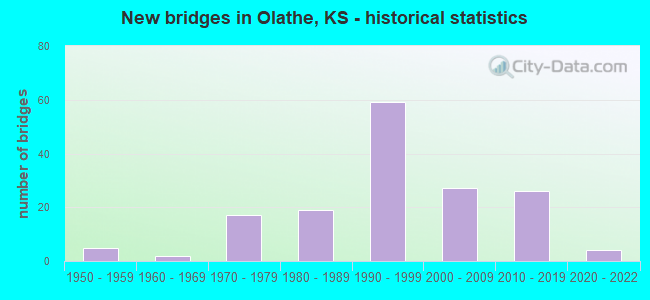
- New bridges - historical statistics
- 51950-1959
- 21960-1969
- 171970-1979
- 191980-1989
- 591990-1999
- 272000-2009
- 262010-2019
- 42020-2022
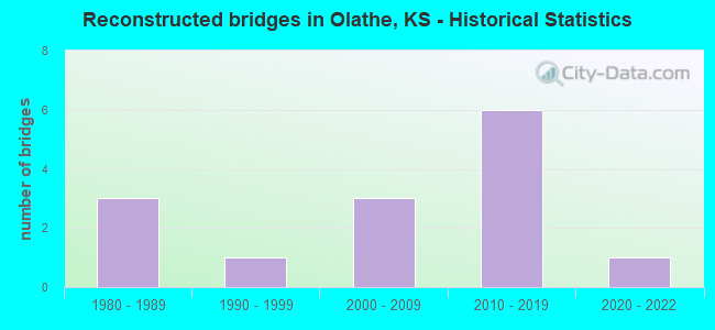
- Reconstructed bridges - Historical Statistics
- 31980-1989
- 11990-1999
- 32000-2009
- 62010-2019
- 12020-2022
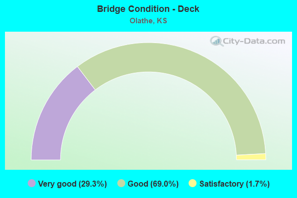
- Bridge Condition - Deck
- 29.3%Very good
- 69.0%Good
- 1.7%Satisfactory
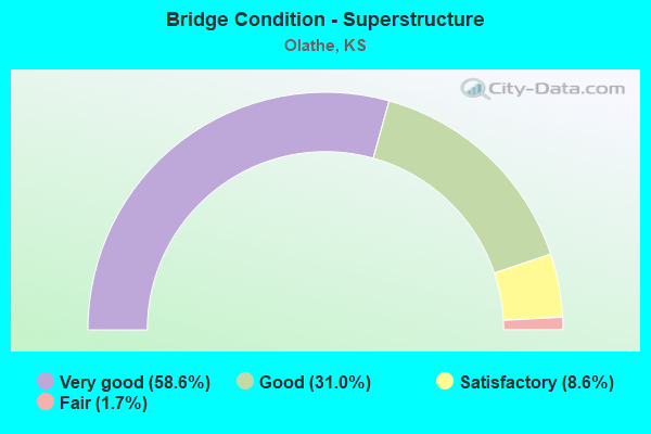
- Bridge Condition - Superstructure
- 58.6%Very good
- 31.0%Good
- 8.6%Satisfactory
- 1.7%Fair
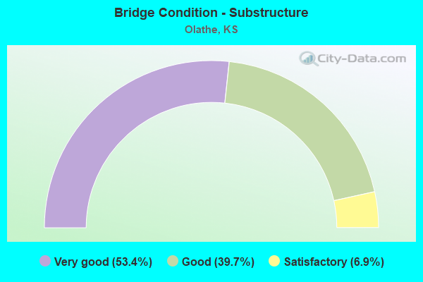
- Bridge Condition - Substructure
- 53.4%Very good
- 39.7%Good
- 6.9%Satisfactory
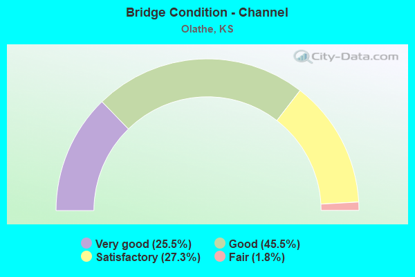
- Bridge Condition - Channel
- 25.5%Very good
- 45.5%Good
- 27.3%Satisfactory
- 1.8%Fair
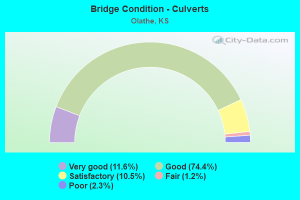
- Bridge Condition - Culverts
- 11.6%Very good
- 74.4%Good
- 10.5%Satisfactory
- 1.2%Fair
- 2.3%Poor
Find on map >> Show street view
Structure Number: 46004, Location: 1.0W OF OLATHE (Lat: 38.883636, Lng: -94.895622), Route carried "on" structure: County highway 208, Year Built: 1990, Status: Open, Structure Length: 5.79m (19.00ft), Average Daily Traffic: 2,352 (year 2016), Truck Traffic: 6%, Average Future Daily Traffic: 2,900 (year 2041), Design Load: HS 20, Features Intersected: TRIB. TO CEDAR CREEK, Facility Carried by Structure: 135TH ST. I.7-10.0
Minimum Vertical Clearance: 30.47m (99.97ft), Kilometerpoint: 0.000, Lanes on structure: 2, Owner: County Highway Agency, Approaching Roadway Width: 7.3m (24.0ft), Skew: 5 degrees, Material/Design: Prestressed concrete continuous, Design/Construction: Stringer/Multi-beam, Number Of Spans In Main Unit: 3, Length of Maximum Span: 21.3m (69.9ft), Curb-To-Curb Width: 12.2m (40.0ft), Out-to-Out Width: 12.8m (42.0ft)
Condition: Deck: Very good, Superstructure: Very good, Substructure: Very good, Channel: Good, Operating Rating: 43.7 metric tons, Method Used To Determine Operating Rating: Load Factor (LF), Inventory Rating: 23.0 metric tons, Method Used To Determine Inventory Rating: Load Factor (LF), Structural Evaluation: Equal to present minimum criteria, Deck Geometry: Equal to present minimum criteria, Waterway Adequacy: Equal to present desirable criteria, Approach Roadway Alignment: Equal to present desirable criteria, Designated Inspection Frequency: Every 24 months, Inspection Date: March 2021, Deck Structure Type: Concrete Cast-file-Place, Wearing Surface/Protective System: Wearing Surface: Epoxy Overlay
Find on map >> Show street view
Structure Number: 46005, Location: 1.4N 2.5W OF US56 & K150 (Lat: 38.883644, Lng: -94.880069), Route carried "on" structure: County highway 208, Year Built: 1978, Status: Open, Structure Length: 3.14m (10.30ft), Average Daily Traffic: 2,860 (year 2016), Truck Traffic: 6%, Average Future Daily Traffic: 3,500 (year 2041), Design Load: HS 20, Features Intersected: CEDAR CREEK, Facility Carried by Structure: 135TH ST. J.5-10.0
Minimum Vertical Clearance: 30.47m (99.97ft), Kilometerpoint: 0.000, Lanes on structure: 2, Owner: County Highway Agency, Approaching Roadway Width: 7.3m (24.0ft), Material/Design: Concrete continuous, Design/Construction: Slab, Number Of Spans In Main Unit: 3, Length of Maximum Span: 12.2m (40.0ft), Curb-To-Curb Width: 12.2m (40.0ft), Out-to-Out Width: 12.7m (41.7ft)
Condition: Deck: Good, Superstructure: Fair, Substructure: Satisfactory, Channel: Satisfactory, Operating Rating: 49.6 metric tons, Method Used To Determine Operating Rating: Load Factor (LF), Inventory Rating: 29.7 metric tons, Method Used To Determine Inventory Rating: Load Factor (LF), Structural Evaluation: Somewhat better than minimum adequacy, Deck Geometry: Equal to present minimum criteria, Waterway Adequacy: Better than present minimum criteria, Approach Roadway Alignment: Equal to present desirable criteria, Designated Inspection Frequency: Every 24 months, Inspection Date: March 2021, Deck Structure Type: Concrete Cast-file-Place
Find on map >> Show street view
Structure Number: 4604, Location: 2.0S 3.9W INT. K7 & K-10 (Lat: 38.912867, Lng: -94.926322), Route carried "on" structure: County highway 2240, Year Built: 1995, Status: Open, Structure Length: 1.14m (3.74ft), Average Daily Traffic: 287 (year 2016), Truck Traffic: 6%, Average Future Daily Traffic: 350 (year 2041), Design Load: HS 20, Features Intersected: CAMP CREEK, Facility Carried by Structure: 119TH ST. H.1-12.0
Minimum Vertical Clearance: 30.47m (99.97ft), Kilometerpoint: 0.000, Lanes on structure: 2, Owner: County Highway Agency, Approaching Roadway Width: 7.3m (24.0ft), Material/Design: Concrete, Design/Construction: Culvert, Number Of Spans In Main Unit: 3, Length of Maximum Span: 3.7m (12.1ft), Curb-To-Curb Width: 9.6m (31.5ft), Out-to-Out Width: 11.0m (36.1ft)
Condition: Channel: Satisfactory, Culverts: Good, Inventory Rating: 64.0 metric tons, Method Used To Determine Inventory Rating: Load Factor (LF), Structural Evaluation: Better than present minimum criteria, Deck Geometry: Equal to present minimum criteria, Waterway Adequacy: Equal to present desirable criteria, Approach Roadway Alignment: Equal to present desirable criteria, Designated Inspection Frequency: Every 24 months, Inspection Date: March 2021
Find on map >> Show street view
Structure Number: 46045, Location: 2.0S 4.0W INT. K7 AND K10 (Lat: 38.912867, Lng: -94.927592), Route carried "on" structure: County highway 2240, Year Built: 1995, Status: Open, Structure Length: 0.64m (2.10ft), Average Daily Traffic: 292 (year 2016), Truck Traffic: 6%, Average Future Daily Traffic: 350 (year 2041), Design Load: HS 20, Features Intersected: CAMP CREEK, Facility Carried by Structure: 119TH ST G.95-12.0
Minimum Vertical Clearance: 30.47m (99.97ft), Kilometerpoint: 0.000, Lanes on structure: 2, Owner: County Highway Agency, Approaching Roadway Width: 7.3m (24.0ft), Skew: 4 degrees, Material/Design: Concrete, Design/Construction: Culvert, Number Of Spans In Main Unit: 2, Length of Maximum Span: 3.0m (9.8ft)
Condition: Channel: Good, Culverts: Good, Inventory Rating: 63.3 metric tons, Method Used To Determine Inventory Rating: Load Factor (LF), Structural Evaluation: Better than present minimum criteria, Waterway Adequacy: Equal to present minimum criteria, Approach Roadway Alignment: Equal to present desirable criteria, Designated Inspection Frequency: Every 24 months, Inspection Date: March 2021
Find on map >> Show street view
Structure Number: 461079004565, Location: 3.0 N 0.5E OF GARDNER (Lat: 38.903081, Lng: -94.927253), Route carried "on" structure: County highway , Year Built: 2000, Status: Open, Structure Length: 0.97m (3.18ft), Average Daily Traffic: 1,124 (year 2016), Truck Traffic: 6%, Average Future Daily Traffic: 1,350 (year 2041), Design Load: HS 20+Mod, Features Intersected: Kill Creek Trib., Facility Carried by Structure: GARDNER H.00-8.46
Minimum Vertical Clearance: 30.47m (99.97ft), Kilometerpoint: 0.000, Lanes on structure: 2, Owner: County Highway Agency, Approaching Roadway Width: 7.3m (24.0ft), Material/Design: Concrete, Design/Construction: Culvert, Number Of Spans In Main Unit: 3, Length of Maximum Span: 3.0m (9.8ft)
Condition: Channel: Satisfactory, Culverts: Good, Operating Rating: 67.1 metric tons, Method Used To Determine Operating Rating: Load Factor (LF), Inventory Rating: 39.9 metric tons, Method Used To Determine Inventory Rating: Load Factor (LF), Structural Evaluation: Better than present minimum criteria, Waterway Adequacy: Equal to present desirable criteria, Approach Roadway Alignment: Equal to present desirable criteria, Designated Inspection Frequency: Every 24 months, Inspection Date: March 2021
Find on map >> Show street view
Structure Number: 461079104485, Location: 2.7S OF K-10 (Lat: 38.920033, Lng: -94.926922), Route carried "on" structure: County highway , Year Built: 1998, Status: Open, Structure Length: 1.24m (4.07ft), Average Daily Traffic: 88 (year 2016), Truck Traffic: 6%, Average Future Daily Traffic: 110 (year 2041), Design Load: HS 20, Features Intersected: CAMP CREEK, Facility Carried by Structure: 115TH ST. H.1-12.5
Minimum Vertical Clearance: 30.47m (99.97ft), Kilometerpoint: 0.000, Lanes on structure: 2, Owner: County Highway Agency, Approaching Roadway Width: 7.3m (24.0ft), Material/Design: Concrete, Design/Construction: Culvert, Number Of Spans In Main Unit: 2, Length of Maximum Span: 6.1m (20.0ft)
Condition: Channel: Good, Culverts: Very good, Operating Rating: 72.9 metric tons, Method Used To Determine Operating Rating: Load Factor (LF), Inventory Rating: 43.6 metric tons, Method Used To Determine Inventory Rating: Load Factor (LF), Structural Evaluation: Equal to present desirable criteria, Waterway Adequacy: Equal to present desirable criteria, Approach Roadway Alignment: Equal to present desirable criteria, Designated Inspection Frequency: Every 24 months, Inspection Date: March 2021
Find on map >> Show street view
Structure Number: 46108190456, Location: 3.0N 1.0E OF GARDNER (Lat: 38.869111, Lng: -94.892272), Route carried "on" structure: County highway , Year Built: 1995, Status: Open, Structure Length: 1.80m (5.91ft), Average Daily Traffic: 736 (year 2016), Truck Traffic: 10%, Average Future Daily Traffic: 900 (year 2041), Design Load: HS 20, Features Intersected: CEDAR CREEK W. BRANCH, Facility Carried by Structure: 143RD ST. I.9-9.0
Minimum Vertical Clearance: 30.47m (99.97ft), Kilometerpoint: 0.000, Lanes on structure: 2, Owner: County Highway Agency, Approaching Roadway Width: 7.3m (24.0ft), Skew: 4 degrees, Material/Design: Concrete, Design/Construction: Culvert, Number Of Spans In Main Unit: 4, Length of Maximum Span: 4.3m (14.1ft)
Condition: Channel: Satisfactory, Culverts: Good, Operating Rating: 83.7 metric tons, Method Used To Determine Operating Rating: Load Factor (LF), Inventory Rating: 49.5 metric tons, Method Used To Determine Inventory Rating: Load Factor (LF), Structural Evaluation: Better than present minimum criteria, Waterway Adequacy: Equal to present desirable criteria, Approach Roadway Alignment: Equal to present desirable criteria, Designated Inspection Frequency: Every 24 months, Inspection Date: March 2021
Find on map >> Show street view
Structure Number: 46108310452, Location: 2.1E OF GARDNER RD. (Lat: 38.898206, Lng: -94.887842), Route carried "on" structure: County highway , Year Built: 1997, Status: Open, Structure Length: 4.05m (13.29ft), Average Daily Traffic: 916 (year 2016), Truck Traffic: 10%, Average Future Daily Traffic: 1,100 (year 2041), Design Load: HS 20, Features Intersected: CEDAR CREEK, Facility Carried by Structure: 127TH ST. J.1-11.0
Minimum Vertical Clearance: 30.47m (99.97ft), Kilometerpoint: 0.000, Lanes on structure: 2, Owner: County Highway Agency, Approaching Roadway Width: 7.3m (24.0ft), Material/Design: Prestressed concrete continuous, Design/Construction: Stringer/Multi-beam, Number Of Spans In Main Unit: 3, Length of Maximum Span: 15.2m (49.9ft), Curb-To-Curb Width: 9.8m (32.2ft), Out-to-Out Width: 10.4m (34.1ft)
Condition: Deck: Good, Superstructure: Very good, Substructure: Good, Channel: Very good, Operating Rating: 73.8 metric tons, Method Used To Determine Operating Rating: Load Factor (LF), Inventory Rating: 44.1 metric tons, Method Used To Determine Inventory Rating: Load Factor (LF), Structural Evaluation: Better than present minimum criteria, Deck Geometry: Equal to present minimum criteria, Waterway Adequacy: Equal to present desirable criteria, Approach Roadway Alignment: Equal to present desirable criteria, Designated Inspection Frequency: Every 24 months, Inspection Date: March 2021, Deck Structure Type: Concrete Cast-file-Place, Wearing Surface/Protective System: Wearing Surface: Epoxy Overlay, Deck Protection: Epoxy Coated Reinforcing
Find on map >> Show street view
Structure Number: 461085004609, Location: 3.0E 1.1N OF GARDNER (Lat: 38.831300, Lng: -94.871269), Route carried "on" structure: County highway , Year Built: 1990, Status: Open, Structure Length: 0.73m (2.40ft), Average Daily Traffic: 596 (year 2016), Truck Traffic: 6%, Average Future Daily Traffic: 750 (year 2041), Design Load: HS 20, Features Intersected: CREEK, Facility Carried by Structure: CLARE RD K.0-6.1
Minimum Vertical Clearance: 30.47m (99.97ft), Kilometerpoint: 0.000, Lanes on structure: 2, Owner: County Highway Agency, Approaching Roadway Width: 7.3m (24.0ft), Skew: 3 degrees, Material/Design: Concrete, Design/Construction: Culvert, Number Of Spans In Main Unit: 2, Length of Maximum Span: 3.4m (11.2ft)
Condition: Channel: Good, Culverts: Good, Operating Rating: 53.1 metric tons, Method Used To Determine Operating Rating: Allowable Stress (AS), Inventory Rating: 32.4 metric tons, Method Used To Determine Inventory Rating: Allowable Stress (AS), Structural Evaluation: Better than present minimum criteria, Waterway Adequacy: Equal to present desirable criteria, Approach Roadway Alignment: Equal to present minimum criteria, Designated Inspection Frequency: Every 24 months, Inspection Date: March 2021
Find on map >> Show street view
Structure Number: 4610851045, Location: 0.9W 2.0S OF WK-10 & K-7 (Lat: 38.913217, Lng: -94.869706), Route carried "on" structure: County highway , Year Built: 1989, Status: Open, Structure Length: 3.14m (10.30ft), Average Daily Traffic: 790 (year 2016), Truck Traffic: 6%, Average Future Daily Traffic: 980 (year 2041), Design Load: HS 20, Features Intersected: LITTLE CEDAR CREEK, Facility Carried by Structure: 119TH ST. K.1-12.0
Minimum Vertical Clearance: 30.47m (99.97ft), Kilometerpoint: 0.000, Lanes on structure: 2, Owner: County Highway Agency, Approaching Roadway Width: 7.3m (24.0ft), Skew: 3 degrees, Material/Design: Concrete continuous, Design/Construction: Slab, Number Of Spans In Main Unit: 3, Length of Maximum Span: 12.2m (40.0ft), Curb-To-Curb Width: 9.8m (32.2ft), Out-to-Out Width: 10.4m (34.1ft)
Condition: Deck: Good, Superstructure: Good, Substructure: Good, Channel: Good, Operating Rating: 64.0 metric tons, Method Used To Determine Operating Rating: Load Factor (LF), Inventory Rating: 38.4 metric tons, Method Used To Determine Inventory Rating: Load Factor (LF), Structural Evaluation: Better than present minimum criteria, Deck Geometry: Equal to present minimum criteria, Waterway Adequacy: Equal to present minimum criteria, Approach Roadway Alignment: Equal to present desirable criteria, Designated Inspection Frequency: Every 24 months, Inspection Date: March 2021, Deck Structure Type: Concrete Cast-file-Place
Find on map >> Show street view
Structure Number: 4610854045, Location: 2.0S 0.8W OF WK10 & K7 (Lat: 38.912456, Lng: -94.862936), Route carried "on" structure: County highway , Year Built: 1993, Status: Open, Structure Length: 4.35m (14.27ft), Average Daily Traffic: 6,865 (year 2016), Truck Traffic: 6%, Average Future Daily Traffic: 8,500 (year 2041), Design Load: HS 20, Features Intersected: LITTLE CEDAR CREEK, Facility Carried by Structure: 119TH ST. K.4-12.0
Minimum Vertical Clearance: 30.47m (99.97ft), Kilometerpoint: 0.000, Lanes on structure: 2, Owner: County Highway Agency, Approaching Roadway Width: 8.1m (26.6ft), Skew: 2 degrees, Material/Design: Concrete continuous, Design/Construction: Slab, Number Of Spans In Main Unit: 3, Length of Maximum Span: 17.1m (56.1ft), Curb or Sidewalk Widths: Left: 0.0m, Right: 1.6m (5.2ft), Curb-To-Curb Width: 9.8m (32.2ft), Out-to-Out Width: 12.2m (40.0ft)
Condition: Deck: Very good, Superstructure: Very good, Substructure: Good, Channel: Good, Operating Rating: 55.9 metric tons, Method Used To Determine Operating Rating: Load Factor (LF), Inventory Rating: 33.5 metric tons, Method Used To Determine Inventory Rating: Load Factor (LF), Structural Evaluation: Better than present minimum criteria, Deck Geometry: Meets minimum limits, Waterway Adequacy: Equal to present desirable criteria, Approach Roadway Alignment: Better than present minimum criteria, Designated Inspection Frequency: Every 24 months, Inspection Date: March 2021, Deck Structure Type: Concrete Cast-file-Place, Wearing Surface/Protective System: Wearing Surface: Epoxy Overlay
Find on map >> Show street view
Structure Number: 461085904567, Location: 3.3W OF I-35 (Lat: 38.859197, Lng: -94.854242), Route carried "on" structure: City street , Year Built: 1985, Year Reconstructed: 2010, Status: Open, Structure Length: 4.95m (16.24ft), Average Daily Traffic: 8,975 (year 2010), Truck Traffic: 20%, Average Future Daily Traffic: 12,960 (year 2043), Design Load: HS 20, Features Intersected: CEDAR CREEK, Facility Carried by Structure: OLD HWY 56 #66
Minimum Vertical Clearance: 30.47m (99.97ft), Kilometerpoint: 0.000, Lanes on structure: 2, Owner: City or Municipal Highway Agency, Approaching Roadway Width: 12.1m (39.7ft), Material/Design: Concrete continuous, Design/Construction: Slab, Number Of Spans In Main Unit: 3, Length of Maximum Span: 19.5m (64.0ft), Curb-To-Curb Width: 13.4m (44.0ft), Out-to-Out Width: 14.0m (45.9ft)
Condition: Deck: Good, Superstructure: Good, Substructure: Good, Channel: Satisfactory, Operating Rating: 73.4 metric tons, Method Used To Determine Operating Rating: Load Factor (LF), Inventory Rating: 43.9 metric tons, Method Used To Determine Inventory Rating: Load Factor (LF), Structural Evaluation: Better than present minimum criteria, Deck Geometry: Equal to present minimum criteria, Waterway Adequacy: Better than present minimum criteria, Approach Roadway Alignment: Better than present minimum criteria, Designated Inspection Frequency: Every 24 months, Inspection Date: May 2021, Deck Structure Type: Concrete Cast-file-Place, Wearing Surface/Protective System: Wearing Surface: Epoxy Overlay
Find on map >> Show street view
Structure Number: 461087004687, Location: 1.0W 1.2N OF SPRING HILL (Lat: 38.771464, Lng: -94.853292), Route carried "on" structure: County highway , Year Built: 1995, Status: Open, Structure Length: 2.13m (6.99ft), Average Daily Traffic: 152 (year 2016), Truck Traffic: 6%, Average Future Daily Traffic: 180 (year 2041), Design Load: HS 20, Features Intersected: BAIN CREEK, Facility Carried by Structure: HEDGE LN L.0-2.3
Minimum Vertical Clearance: 30.47m (99.97ft), Kilometerpoint: 0.000, Lanes on structure: 2, Owner: County Highway Agency, Approaching Roadway Width: 7.3m (24.0ft), Skew: 4 degrees, Material/Design: Concrete, Design/Construction: Culvert, Number Of Spans In Main Unit: 3, Length of Maximum Span: 7.0m (23.0ft)
Condition: Channel: Satisfactory, Culverts: Good, Operating Rating: 89.8 metric tons, Method Used To Determine Operating Rating: Load Factor (LF), Inventory Rating: 61.2 metric tons, Method Used To Determine Inventory Rating: Load Factor (LF), Structural Evaluation: Better than present minimum criteria, Waterway Adequacy: Equal to present desirable criteria, Approach Roadway Alignment: Better than present minimum criteria, Designated Inspection Frequency: Every 24 months, Inspection Date: March 2021
Find on map >> Show street view
Structure Number: 4610871046, Location: 1.02 MI W. OF LONE ELM RD (Lat: 38.840072, Lng: -94.853156), Route carried "on" structure: ServiceCity street 2730, Year Built: 1960, Status: Open, Structure Length: 1.01m (3.31ft), Average Daily Traffic: 5 (year 2017), Truck Traffic: 5%, Average Future Daily Traffic: 5 (year 2043), Design Load: H 15, Features Intersected: CEDAR CREEK, Facility Carried by Structure: 159TH SERVICE RD
Minimum Vertical Clearance: 30.47m (99.97ft), Kilometerpoint: 0.000, Lanes on structure: 2, Owner: City or Municipal Highway Agency, Approaching Roadway Width: 7.3m (24.0ft), Material/Design: Concrete, Design/Construction: Culvert, Number Of Spans In Main Unit: 3, Length of Maximum Span: 3.0m (9.8ft), Curb-To-Curb Width: 8.0m (26.2ft), Out-to-Out Width: 8.0m (26.2ft)
Condition: Channel: Satisfactory, Culverts: Satisfactory, Operating Rating: 32.7 metric tons, Method Used To Determine Operating Rating: Field evaluation and documented engineering judgment, Inventory Rating: 32.7 metric tons, Method Used To Determine Inventory Rating: Field evaluation and documented engineering judgment, Structural Evaluation: Equal to present minimum criteria, Deck Geometry: Equal to present minimum criteria, Waterway Adequacy: Better than present minimum criteria, Approach Roadway Alignment: Meets minimum limits, Designated Inspection Frequency: Every 24 months, Inspection Date: May 2021, Other Special Inspection Date: May 2021
Find on map >> Show street view
Structure Number: 461089004609, Location: 0.23 N OF 167TH ST. (Lat: 38.828875, Lng: -94.834442), Route carried "on" structure: City street , Year Built: 2002, Status: Open, Structure Length: 0.63m (2.07ft), Average Daily Traffic: 7,830 (year 2010), Truck Traffic: 6%, Average Future Daily Traffic: 11,280 (year 2043), Design Load: HS 20, Features Intersected: CEDAR CREEK TRIB., Facility Carried by Structure: LONE ELM RD #95
Minimum Vertical Clearance: 30.47m (99.97ft), Kilometerpoint: 0.000, Lanes on structure: 2, Owner: City or Municipal Highway Agency, Approaching Roadway Width: 13.4m (44.0ft), Material/Design: Concrete, Design/Construction: Culvert, Number Of Spans In Main Unit: 2, Length of Maximum Span: 3.0m (9.8ft)
Condition: Channel: Very good, Culverts: Good, Operating Rating: 32.7 metric tons, Method Used To Determine Operating Rating: Field evaluation and documented engineering judgment, Inventory Rating: 32.7 metric tons, Method Used To Determine Inventory Rating: Field evaluation and documented engineering judgment, Structural Evaluation: Better than present minimum criteria, Waterway Adequacy: Equal to present desirable criteria, Approach Roadway Alignment: Equal to present desirable criteria, Designated Inspection Frequency: Every 24 months, Inspection Date: May 2021
Find on map >> Show street view
Structure Number: 461089004648, Location: 0.5W 0.1N US169 & 183RD. (Lat: 38.799394, Lng: -94.834400), Route carried "on" structure: County highway , Year Built: 1997, Status: Open, Structure Length: 0.70m (2.30ft), Average Daily Traffic: 1,194 (year 2016), Truck Traffic: 6%, Average Future Daily Traffic: 1,500 (year 2041), Design Load: HS 20, Features Intersected: BAIN CREEK TRIB., Facility Carried by Structure: LONE ELM M.0-4.15
Minimum Vertical Clearance: 30.47m (99.97ft), Kilometerpoint: 0.000, Lanes on structure: 2, Owner: County Highway Agency, Approaching Roadway Width: 9.7m (31.8ft), Skew: 4 degrees, Material/Design: Concrete, Design/Construction: Culvert, Number Of Spans In Main Unit: 2, Length of Maximum Span: 3.5m (11.5ft), Curb-To-Curb Width: 10.8m (35.4ft), Out-to-Out Width: 11.3m (37.1ft)
Condition: Channel: Very good, Culverts: Good, Operating Rating: 55.8 metric tons, Method Used To Determine Operating Rating: Load Factor (LF), Inventory Rating: 33.3 metric tons, Method Used To Determine Inventory Rating: Load Factor (LF), Structural Evaluation: Better than present minimum criteria, Deck Geometry: Equal to present minimum criteria, Waterway Adequacy: Equal to present desirable criteria, Approach Roadway Alignment: Equal to present desirable criteria, Designated Inspection Frequency: Every 24 months, Inspection Date: March 2021
Find on map >> Show street view
Structure Number: 461097004589, Location: 2.1N 3.0E OF BONITA (Lat: 38.842189, Lng: -94.761178), Route carried "on" structure: City street , Year Built: 1991, Status: Open, Structure Length: 0.64m (2.10ft), Average Daily Traffic: 8,313 (year 2016), Truck Traffic: 6%, Average Future Daily Traffic: 10,000 (year 2043), Design Load: HS 20, Features Intersected: CREEK, Facility Carried by Structure: LACKMAN RD #112
Minimum Vertical Clearance: 30.47m (99.97ft), Kilometerpoint: 0.000, Lanes on structure: 2, Owner: City or Municipal Highway Agency, Approaching Roadway Width: 9.7m (31.8ft), Material/Design: Concrete, Design/Construction: Culvert, Number Of Spans In Main Unit: 2, Length of Maximum Span: 3.0m (9.8ft), Curb-To-Curb Width: 9.8m (32.2ft), Out-to-Out Width: 12.0m (39.4ft)
Condition: Channel: Satisfactory, Culverts: Good, Operating Rating: 85.7 metric tons, Method Used To Determine Operating Rating: Load Factor (LF), Inventory Rating: 51.3 metric tons, Method Used To Determine Inventory Rating: Load Factor (LF), Structural Evaluation: Better than present minimum criteria, Deck Geometry: Meets minimum limits, Waterway Adequacy: Better than present minimum criteria, Approach Roadway Alignment: Equal to present desirable criteria, Designated Inspection Frequency: Every 24 months, Inspection Date: May 2021
Find on map >> Show street view
Structure Number: 461097004622, Location: 0.8N 3.0E OF BONITA (Lat: 38.822678, Lng: -94.761200), Route carried "on" structure: County highway , Year Built: 1988, Status: Open, Structure Length: 1.19m (3.90ft), Average Daily Traffic: 2,334 (year 2016), Truck Traffic: 6%, Average Future Daily Traffic: 2,800 (year 2041), Design Load: HS 20, Features Intersected: COFFEE CREEK, Facility Carried by Structure: LACKMAN Q.0-5.8
Minimum Vertical Clearance: 30.47m (99.97ft), Kilometerpoint: 0.000, Lanes on structure: 2, Owner: County Highway Agency, Approaching Roadway Width: 7.3m (24.0ft), Material/Design: Concrete, Design/Construction: Culvert, Number Of Spans In Main Unit: 3, Length of Maximum Span: 4.0m (13.1ft)
Condition: Channel: Satisfactory, Culverts: Satisfactory, Operating Rating: 48.6 metric tons, Method Used To Determine Operating Rating: Allowable Stress (AS), Inventory Rating: 27.9 metric tons, Method Used To Determine Inventory Rating: Allowable Stress (AS), Structural Evaluation: Equal to present minimum criteria, Waterway Adequacy: Better than present minimum criteria, Approach Roadway Alignment: Better than present minimum criteria, Designated Inspection Frequency: Every 24 months, Inspection Date: March 2021
Find on map >> Show street view
Structure Number: 4610973046, Location: 3.3 MI. E OF K-7/US-169 (Lat: 38.840228, Lng: -94.754967), Route carried "on" structure: County highway , Year Built: 1974, Year Reconstructed: 2019, Status: Open, Structure Length: 1.33m (4.36ft), Average Daily Traffic: 8,121 (year 2016), Truck Traffic: 6%, Average Future Daily Traffic: 10,000 (year 2041), Design Load: H 20, Features Intersected: COFFEE CREEK TRIBUTARY, Facility Carried by Structure: 159TH ST. Q.3-7.0
Minimum Vertical Clearance: 30.47m (99.97ft), Kilometerpoint: 0.000, Lanes on structure: 2, Owner: County Highway Agency, Approaching Roadway Width: 10.9m (35.8ft), Material/Design: Concrete, Design/Construction: Culvert, Number Of Spans In Main Unit: 3, Length of Maximum Span: 4.3m (14.1ft), Curb-To-Curb Width: 11.1m (36.4ft), Out-to-Out Width: 16.1m (52.8ft)
Condition: Channel: Good, Culverts: Good, Operating Rating: 58.5 metric tons, Method Used To Determine Operating Rating: Allowable Stress (AS), Inventory Rating: 38.7 metric tons, Method Used To Determine Inventory Rating: Allowable Stress (AS), Structural Evaluation: Better than present minimum criteria, Deck Geometry: Meets minimum limits, Waterway Adequacy: Better than present minimum criteria, Approach Roadway Alignment: Better than present minimum criteria, Designated Inspection Frequency: Every 24 months, Inspection Date: March 2021
Find on map >> Show street view
Structure Number: 461097404585, Location: 0.12 MI. E. OF ACUFF LN. (Lat: 38.847336, Lng: -94.753522), Route carried "on" structure: County highway 16242, Year Built: 1989, Year Reconstructed: 2019, Status: Open, Structure Length: 0.78m (2.56ft), Average Daily Traffic: 500 (year 2020), Truck Traffic: 2%, Average Future Daily Traffic: 550 (year 2041), Design Load: HS 20, Features Intersected: COFFEE CREEK TRIB., Facility Carried by Structure: 155 TERR Q.41-7.49
Minimum Vertical Clearance: 30.47m (99.97ft), Kilometerpoint: 0.000, Lanes on structure: 2, Owner: County Highway Agency, Approaching Roadway Width: 7.3m (24.0ft), Material/Design: Concrete, Design/Construction: Culvert, Number Of Spans In Main Unit: 3, Length of Maximum Span: 2.4m (7.9ft), Curb-To-Curb Width: 7.3m (24.0ft), Out-to-Out Width: 10.7m (35.1ft)
Condition: Channel: Satisfactory, Culverts: Good, Operating Rating: 38.9 metric tons, Method Used To Determine Operating Rating: Load Factor (LF), Inventory Rating: 23.3 metric tons, Method Used To Determine Inventory Rating: Load Factor (LF), Structural Evaluation: Equal to present minimum criteria, Deck Geometry: Meets minimum limits, Waterway Adequacy: Better than present minimum criteria, Approach Roadway Alignment: Equal to present desirable criteria, Designated Inspection Frequency: Every 24 months, Inspection Date: March 2021
Find on map >> Show street view
Structure Number: 421200464202023, Location: 0.4E OF PARKER (Lat: 38.869111, Lng: -94.826494), Route carried "on" structure: City street , Year Built: 1998, Status: Open, Structure Length: 0.68m (2.23ft), Average Daily Traffic: 4,085 (year 2010), Truck Traffic: 5%, Average Future Daily Traffic: 5,770 (year 2043), Design Load: HS 20, Features Intersected: LITTLE CEDAR CREEK TRIB., Facility Carried by Structure: DENNIS AVENUE #23
Minimum Vertical Clearance: 30.47m (99.97ft), Kilometerpoint: 0.000, Lanes on structure: 2, Owner: City or Municipal Highway Agency, Approaching Roadway Width: 10.5m (34.4ft), Material/Design: Concrete, Design/Construction: Culvert, Number Of Spans In Main Unit: 3, Length of Maximum Span: 2.1m (6.9ft), Curb or Sidewalk Widths: Left: 1.5m (4.9ft), Right: 0.0m
Condition: Channel: Good, Culverts: Good, Operating Rating: 32.7 metric tons, Method Used To Determine Operating Rating: Field evaluation and documented engineering judgment, Inventory Rating: 32.7 metric tons, Method Used To Determine Inventory Rating: Field evaluation and documented engineering judgment, Structural Evaluation: Better than present minimum criteria, Waterway Adequacy: Better than present minimum criteria, Approach Roadway Alignment: Equal to present desirable criteria, Designated Inspection Frequency: Every 24 months, Inspection Date: May 2021, Wearing Surface/Protective System: Deck Protection: Epoxy Coated Reinforcing
Find on map >> Show street view
Structure Number: 421200464202024, Location: 0.3E OF HARRISON (Lat: 38.869111, Lng: -94.810789), Route carried "on" structure: City street 4202, Year Built: 1975, Status: Open, Structure Length: 0.76m (2.49ft), Average Daily Traffic: 6,730 (year 2005), Truck Traffic: 5%, Average Future Daily Traffic: 9,700 (year 2043), Design Load: H 20, Features Intersected: MILL CREEK TRIBUTARY, Facility Carried by Structure: Dennis#24
Minimum Vertical Clearance: 30.47m (99.97ft), Kilometerpoint: 0.000, Lanes on structure: 2, Owner: City or Municipal Highway Agency, Approaching Roadway Width: 10.6m (34.8ft), Material/Design: Concrete, Design/Construction: Culvert, Number Of Spans In Main Unit: 2, Length of Maximum Span: 3.7m (12.1ft)
Condition: Channel: Satisfactory, Culverts: Good, Operating Rating: 32.7 metric tons, Method Used To Determine Operating Rating: Field evaluation and documented engineering judgment, Inventory Rating: 32.7 metric tons, Method Used To Determine Inventory Rating: Field evaluation and documented engineering judgment, Structural Evaluation: Better than present minimum criteria, Waterway Adequacy: Better than present minimum criteria, Approach Roadway Alignment: Equal to present desirable criteria, Designated Inspection Frequency: Every 24 months, Inspection Date: May 2021
Find on map >> Show street view
Structure Number: 421200464202071, Location: 405 FT N OF 143RD ST (Lat: 38.870267, Lng: -94.742414), Route carried "on" structure: City street , Year Built: 2005, Status: Open, Structure Length: 3.08m (10.10ft), Average Daily Traffic: 5,400 (year 2010), Truck Traffic: 3%, Average Future Daily Traffic: 7,800 (year 2043), Design Load: HS 20, Features Intersected: TOMAHAWK CREEK, Facility Carried by Structure: SB PFLUMM #71
Minimum Vertical Clearance: 30.47m (99.97ft), Kilometerpoint: 0.000, Lanes on structure: 3, Owner: City or Municipal Highway Agency, Approaching Roadway Width: 7.9m (25.9ft), Skew: 1 degrees, Material/Design: Concrete continuous, Design/Construction: Slab, Number Of Spans In Main Unit: 3, Length of Maximum Span: 12.0m (39.4ft), Curb or Sidewalk Widths: Left: 1.9m (6.2ft), Right: 0.0m, Curb-To-Curb Width: 12.9m (42.3ft), Out-to-Out Width: 15.6m (51.2ft)
Condition: Deck: Good, Superstructure: Good, Substructure: Very good, Channel: Very good, Operating Rating: 60.0 metric tons, Method Used To Determine Operating Rating: Load Factor (LF), Inventory Rating: 35.9 metric tons, Method Used To Determine Inventory Rating: Load Factor (LF), Structural Evaluation: Better than present minimum criteria, Deck Geometry: Meets minimum limits, Waterway Adequacy: Equal to present desirable criteria, Approach Roadway Alignment: Equal to present desirable criteria, Designated Inspection Frequency: Every 24 months, Inspection Date: May 2021, Deck Structure Type: Concrete Cast-file-Place, Wearing Surface/Protective System: Deck Protection: Epoxy Coated Reinforcing
Find on map >> Show street view
Structure Number: 421200464202072, Location: 143RD ST. AT W SIDE PFLUM (Lat: 38.869100, Lng: -94.742617), Route carried "on" structure: City street , Year Built: 2003, Status: Open, Structure Length: 0.67m (2.20ft), Average Daily Traffic: 9,690 (year 2008), Truck Traffic: 3%, Average Future Daily Traffic: 13,920 (year 2043), Design Load: HS 20, Features Intersected: TRIB. TO TOMAHAWK CREEK, Facility Carried by Structure: 143RD/SUMMIT #72
Minimum Vertical Clearance: 30.47m (99.97ft), Kilometerpoint: 0.000, Lanes on structure: 3, Owner: City or Municipal Highway Agency, Approaching Roadway Width: 10.9m (35.8ft), Skew: 22 degrees, Material/Design: Concrete, Design/Construction: Culvert, Number Of Spans In Main Unit: 2, Length of Maximum Span: 3.3m (10.8ft), Curb or Sidewalk Widths: Left: 1.5m (4.9ft), Right: 1.5m (4.9ft)
Condition: Channel: Good, Culverts: Good, Operating Rating: 68.7 metric tons, Method Used To Determine Operating Rating: Load Factor (LF), Inventory Rating: 41.1 metric tons, Method Used To Determine Inventory Rating: Load Factor (LF), Structural Evaluation: Better than present minimum criteria, Waterway Adequacy: Equal to present desirable criteria, Approach Roadway Alignment: Equal to present desirable criteria, Designated Inspection Frequency: Every 24 months, Inspection Date: May 2021
Find on map >> Show street view
Structure Number: 421200464204026, Location: 0.2E OF MUR-LEN (Lat: 38.869100, Lng: -94.776386), Route carried "on" structure: City street 4204, Year Built: 1977, Year Reconstructed: 2014, Status: Open, Structure Length: 1.71m (5.61ft), Average Daily Traffic: 10,090 (year 2010), Truck Traffic: 5%, Average Future Daily Traffic: 14,520 (year 2043), Design Load: HS 20, Features Intersected: INDIAN CREEK TRIBUTARY, Facility Carried by Structure: 143RD STREET #26
Minimum Vertical Clearance: 30.47m (99.97ft), Kilometerpoint: 0.000, Lanes on structure: 2, Owner: City or Municipal Highway Agency, Approaching Roadway Width: 10.4m (34.1ft), Skew: 1 degrees, Material/Design: Concrete, Design/Construction: Culvert, Number Of Spans In Main Unit: 5, Length of Maximum Span: 3.0m (9.8ft), Curb or Sidewalk Widths: Left: 1.2m (3.9ft), Right: 1.2m (3.9ft)
Condition: Channel: Very good, Culverts: Good, Operating Rating: 33.6 metric tons, Method Used To Determine Operating Rating: Load Factor (LF), Inventory Rating: 20.0 metric tons, Method Used To Determine Inventory Rating: Load Factor (LF), Structural Evaluation: Somewhat better than minimum adequacy, Waterway Adequacy: Better than present minimum criteria, Approach Roadway Alignment: Equal to present desirable criteria, Designated Inspection Frequency: Every 24 months, Inspection Date: May 2021
Find on map >> Show street view
Structure Number: 421200464204073, Location: 0.2 MI W OF PFLUMM (Lat: 38.869089, Lng: -94.746800), Route carried "on" structure: City street , Year Built: 2000, Status: Open, Structure Length: 1.10m (3.61ft), Average Daily Traffic: 9,690 (year 2008), Truck Traffic: 3%, Average Future Daily Traffic: 13,920 (year 2043), Design Load: HS 20, Features Intersected: TOMAHAWK CREEK, Facility Carried by Structure: 143RD ST. #73
Minimum Vertical Clearance: 30.47m (99.97ft), Kilometerpoint: 0.000, Lanes on structure: 2, Owner: City or Municipal Highway Agency, Approaching Roadway Width: 10.6m (34.8ft), Skew: 4 degrees, Material/Design: Concrete, Design/Construction: Culvert, Number Of Spans In Main Unit: 2, Length of Maximum Span: 5.2m (17.1ft), Curb or Sidewalk Widths: Left: 1.5m (4.9ft), Right: 1.5m (4.9ft)
Condition: Channel: Good, Culverts: Good, Operating Rating: 67.2 metric tons, Method Used To Determine Operating Rating: Load Factor (LF), Inventory Rating: 40.3 metric tons, Method Used To Determine Inventory Rating: Load Factor (LF), Structural Evaluation: Better than present minimum criteria, Waterway Adequacy: Better than present minimum criteria, Approach Roadway Alignment: Equal to present desirable criteria, Designated Inspection Frequency: Every 24 months, Inspection Date: May 2021
Find on map >> Show street view
Structure Number: 421200464205094, Location: .60 MI E OF CEDAR CR PKWY (Lat: 38.943678, Lng: -94.875914), Route carried "on" structure: City street , Year Built: 1996, Status: Open, Structure Length: 0.63m (2.07ft), Average Daily Traffic: 1,000 (year 2013), Truck Traffic: 5%, Average Future Daily Traffic: 1,200 (year 2043), Design Load: HS 20, Features Intersected: CEDAR CREEK TRIBUTARY, Facility Carried by Structure: VALLEY PARKWAY
Minimum Vertical Clearance: 30.47m (99.97ft), Kilometerpoint: 0.000, Lanes on structure: 4, Owner: City or Municipal Highway Agency, Approaching Roadway Width: 16.4m (53.8ft), Skew: 20 degrees, Material/Design: Concrete, Design/Construction: Culvert, Number Of Spans In Main Unit: 2, Length of Maximum Span: 3.1m (10.2ft), Curb or Sidewalk Widths: Left: 0.0m, Right: 1.2m (3.9ft)
Condition: Channel: Good, Culverts: Good, Operating Rating: 32.7 metric tons, Method Used To Determine Operating Rating: Field evaluation and documented engineering judgment, Inventory Rating: 32.7 metric tons, Method Used To Determine Inventory Rating: Field evaluation and documented engineering judgment, Structural Evaluation: Better than present minimum criteria, Waterway Adequacy: Equal to present desirable criteria, Approach Roadway Alignment: Equal to present desirable criteria, Designated Inspection Frequency: Every 24 months, Inspection Date: May 2021
Find on map >> Show street view
Structure Number: 421200464210014, Location: AT PARK AND HARRISON (Lat: 38.882028, Lng: -94.815306), Route carried "on" structure: City street 4210, Year Built: 1978, Status: Open, Structure Length: 0.80m (2.62ft), Average Daily Traffic: 2,000 (year 2011), Truck Traffic: 3%, Average Future Daily Traffic: 2,880 (year 2043), Features Intersected: MILL CREEK, Facility Carried by Structure: PARK STREET #14
Minimum Vertical Clearance: 6.09m (19.98ft), Kilometerpoint: 0.000, Lanes on structure: 2, Owner: City or Municipal Highway Agency, Approaching Roadway Width: 11.6m (38.1ft), Skew: 1 degrees, Material/Design: Concrete, Design/Construction: Culvert, Number Of Spans In Main Unit: 3, Length of Maximum Span: 2.5m (8.2ft), Curb or Sidewalk Widths: Left: 1.6m (5.2ft), Right: 1.8m (5.9ft)
Condition: Channel: Very good, Culverts: Good, Operating Rating: 32.7 metric tons, Method Used To Determine Operating Rating: Field evaluation and documented engineering judgment, Inventory Rating: 32.7 metric tons, Method Used To Determine Inventory Rating: Field evaluation and documented engineering judgment, Structural Evaluation: Better than present minimum criteria, Waterway Adequacy: Better than present minimum criteria, Approach Roadway Alignment: Equal to present desirable criteria, Designated Inspection Frequency: Every 24 months, Inspection Date: May 2021
Find on map >> Show street view
Structure Number: 421200464211074, Location: 0.1 MI WEST OF I-35 (Lat: 38.912883, Lng: -94.773347), Route carried "on" structure: City street , Year Built: 1991, Year Reconstructed: 2021, Status: Open, Structure Length: 10.18m (33.40ft), Average Daily Traffic: 25,400 (year 2016), Truck Traffic: 10%, Average Future Daily Traffic: 35,120 (year 2043), Design Load: HS 20, Features Intersected: BNSF RR AND KC ROAD, Facility Carried by Structure: WB 119TH ST #74
Minimum Vertical Clearance: 30.47m (99.97ft), Kilometerpoint: 0.000, Lanes on structure: 4, Lanes under structure: 4, Owner: City or Municipal Highway Agency, Approaching Roadway Width: 11.1m (36.4ft), Skew: 4 degrees, Material/Design: Steel continuous, Design/Construction: Stringer/Multi-beam, Number Of Spans In Main Unit: 4, Length of Maximum Span: 32.3m (106.0ft), Curb or Sidewalk Widths: Left: 2.1m (6.9ft), Right: 0.0m, Curb-To-Curb Width: 14.6m (47.9ft), Out-to-Out Width: 17.8m (58.4ft)
Condition: Deck: Good, Superstructure: Very good, Substructure: Very good, Operating Rating: 53.7 metric tons, Method Used To Determine Operating Rating: Load Factor (LF), Inventory Rating: 31.8 metric tons, Method Used To Determine Inventory Rating: Load Factor (LF), Structural Evaluation: Better than present minimum criteria, Deck Geometry: High priority of replacement, Underclear: Meets minimum limits, Approach Roadway Alignment: Equal to present desirable criteria, Designated Inspection Frequency: Every 24 months, Inspection Date: January 2022, Deck Structure Type: Concrete Cast-file-Place, Wearing Surface/Protective System: Deck Protection: Epoxy Coated Reinforcing
Find on map >> Show street view
Structure Number: 421200464211075, Location: 0.1 MI WEST OF I-35 (Lat: 38.912717, Lng: -94.773364), Route carried "on" structure: City street , Year Built: 1991, Year Reconstructed: 2021, Status: Open, Structure Length: 10.18m (33.40ft), Average Daily Traffic: 25,400 (year 2016), Truck Traffic: 10%, Average Future Daily Traffic: 35,120 (year 2043), Design Load: HS 20, Features Intersected: BNSF RR AND KC ROAD, Facility Carried by Structure: EB 119TH ST #75
Minimum Vertical Clearance: 30.47m (99.97ft), Kilometerpoint: 0.000, Lanes on structure: 5, Lanes under structure: 4, Owner: City or Municipal Highway Agency, Approaching Roadway Width: 11.1m (36.4ft), Skew: 4 degrees, Material/Design: Steel continuous, Design/Construction: Stringer/Multi-beam, Number Of Spans In Main Unit: 4, Length of Maximum Span: 32.3m (106.0ft), Curb or Sidewalk Widths: Left: 0.0m, Right: 3.0m (9.8ft), Curb-To-Curb Width: 18.0m (59.1ft), Out-to-Out Width: 23.5m (77.1ft)
Condition: Deck: Good, Superstructure: Very good, Substructure: Very good, Operating Rating: 54.7 metric tons, Method Used To Determine Operating Rating: Load Factor (LF), Inventory Rating: 32.7 metric tons, Method Used To Determine Inventory Rating: Load Factor (LF), Structural Evaluation: Equal to present desirable criteria, Deck Geometry: High priority of replacement, Underclear: Meets minimum limits, Approach Roadway Alignment: Equal to present desirable criteria, Designated Inspection Frequency: Every 24 months, Inspection Date: January 2022, Deck Structure Type: Concrete Cast-file-Place, Wearing Surface/Protective System: Deck Protection: Epoxy Coated Reinforcing
Find on map >> Show street view
Structure Number: 421200464214012, Location: 0.1W OF WOODLAND (Lat: 38.886481, Lng: -94.817111), Route carried "on" structure: City street 4214, Year Built: 1975, Status: Open, Structure Length: 0.95m (3.12ft), Average Daily Traffic: 700 (year 2011), Truck Traffic: 3%, Average Future Daily Traffic: 1,020 (year 2043), Features Intersected: MILL CREEK, Facility Carried by Structure: SPRUCE STREET #12
Minimum Vertical Clearance: 6.09m (19.98ft), Kilometerpoint: 0.000, Lanes on structure: 2, Owner: City or Municipal Highway Agency, Approaching Roadway Width: 7.5m (24.6ft), Material/Design: Concrete, Design/Construction: Culvert, Number Of Spans In Main Unit: 3, Length of Maximum Span: 3.0m (9.8ft), Curb or Sidewalk Widths: Left: 0.0m, Right: 1.5m (4.9ft)
Condition: Channel: Satisfactory, Culverts: Satisfactory, Operating Rating: 24.3 metric tons, Method Used To Determine Operating Rating: Load Factor (LF), Inventory Rating: 19.8 metric tons, Method Used To Determine Inventory Rating: Load Factor (LF), Structural Evaluation: Somewhat better than minimum adequacy, Waterway Adequacy: Better than present minimum criteria, Approach Roadway Alignment: Equal to present desirable criteria, Designated Inspection Frequency: Every 24 months, Inspection Date: May 2021
Find on map >> Show street view
Structure Number: 421200464218003, Location: 0.2W OF WOODLAND (Lat: 38.898183, Lng: -94.819361), Route carried "on" structure: City street 4218, Year Built: 1978, Year Reconstructed: 1986, Status: Open, Structure Length: 0.98m (3.22ft), Average Daily Traffic: 7,185 (year 2007), Truck Traffic: 5%, Average Future Daily Traffic: 10,340 (year 2043), Design Load: H 20, Features Intersected: MILL CREEK, Facility Carried by Structure: HAROLD STREET #3
Minimum Vertical Clearance: 30.47m (99.97ft), Kilometerpoint: 0.000, Lanes on structure: 4, Owner: City or Municipal Highway Agency, Approaching Roadway Width: 7.0m (23.0ft), Material/Design: Concrete, Design/Construction: Culvert, Number Of Spans In Main Unit: 3, Length of Maximum Span: 3.0m (9.8ft), Curb or Sidewalk Widths: Left: 0.0m, Right: 1.2m (3.9ft)
Condition: Channel: Good, Culverts: Good, Operating Rating: 32.7 metric tons, Method Used To Determine Operating Rating: Field evaluation and documented engineering judgment, Inventory Rating: 32.7 metric tons, Method Used To Determine Inventory Rating: Field evaluation and documented engineering judgment, Structural Evaluation: Better than present minimum criteria, Waterway Adequacy: Equal to present desirable criteria, Approach Roadway Alignment: Better than present minimum criteria, Designated Inspection Frequency: Every 24 months, Inspection Date: May 2021
Find on map >> Show street view
Structure Number: 421200464218B04, Location: 0.3E OF WOODLAND (Lat: 38.898131, Lng: -94.810950), Route carried "on" structure: City street 4218, Year Built: 2017, Status: Open, Structure Length: 1.58m (5.18ft), Average Daily Traffic: 4,660 (year 2017), Truck Traffic: 5%, Average Future Daily Traffic: 5,500 (year 2043), Design Load: HL 93, Features Intersected: MILL CREEK TRIB., Facility Carried by Structure: HAROLD STREET #4
Minimum Vertical Clearance: 7.04m (23.10ft), Kilometerpoint: 0.000, Lanes on structure: 2, Owner: City or Municipal Highway Agency, Approaching Roadway Width: 10.6m (34.8ft), Material/Design: Concrete, Design/Construction: Slab, Number Of Spans In Main Unit: 1, Length of Maximum Span: 13.7m (44.9ft), Curb or Sidewalk Widths: Left: 1.8m (5.9ft), Right: 1.8m (5.9ft), Curb-To-Curb Width: 10.7m (35.1ft), Out-to-Out Width: 15.5m (50.9ft)
Condition: Deck: Very good, Superstructure: Very good, Substructure: Very good, Channel: Very good, Operating Rating: 97.3 metric tons, Method Used To Determine Operating Rating: Load Factor (LF), Inventory Rating: 58.1 metric tons, Method Used To Determine Inventory Rating: Load Factor (LF), Structural Evaluation: Equal to present desirable criteria, Deck Geometry: Somewhat better than minimum adequacy, Waterway Adequacy: Equal to present desirable criteria, Approach Roadway Alignment: Equal to present desirable criteria, Designated Inspection Frequency: Every 24 months, Inspection Date: May 2021, Deck Structure Type: Concrete Cast-file-Place, Wearing Surface/Protective System: Wearing Surface: Epoxy Overlay, Deck Protection: Epoxy Coated Reinforcing
Find on map >> Show street view
Structure Number: 421200464219008, Location: 0.5S OF 127TH. ST. (Lat: 38.890842, Lng: -94.806711), Route carried "on" structure: City street 4219, Year Built: 1975, Status: Open, Structure Length: 0.63m (2.07ft), Average Daily Traffic: 2,630 (year 2010), Truck Traffic: 3%, Average Future Daily Traffic: 3,840 (year 2043), Design Load: H 15, Features Intersected: MILL CREEK TRIBUTARY, Facility Carried by Structure: NELSON STREET #8
Minimum Vertical Clearance: 6.09m (19.98ft), Kilometerpoint: 0.000, Lanes on structure: 2, Owner: City or Municipal Highway Agency, Approaching Roadway Width: 10.6m (34.8ft), Material/Design: Concrete, Design/Construction: Culvert, Number Of Spans In Main Unit: 2, Length of Maximum Span: 3.0m (9.8ft), Curb or Sidewalk Widths: Left: 1.2m (3.9ft), Right: 1.2m (3.9ft)
Condition: Channel: Good, Culverts: Good, Operating Rating: 29.1 metric tons, Method Used To Determine Operating Rating: Load Factor (LF), Inventory Rating: 17.4 metric tons, Method Used To Determine Inventory Rating: Load Factor (LF), Structural Evaluation: Meets minimum limits, Waterway Adequacy: Better than present minimum criteria, Approach Roadway Alignment: Better than present minimum criteria, Designated Inspection Frequency: Every 24 months, Inspection Date: May 2021
Find on map >> Show street view
Structure Number: 42120046422301, Location: 0.2N.E. OF NELSON (Lat: 38.889097, Lng: -94.803919), Route carried "on" structure: City street 4223, Year Built: 1979, Year Reconstructed: 2004, Status: Open, Structure Length: 1.00m (3.28ft), Average Daily Traffic: 7,405 (year 2010), Truck Traffic: 5%, Average Future Daily Traffic: 10,680 (year 2043), Design Load: H 20, Features Intersected: MILL CREEK TRIB., Facility Carried by Structure: KANSAS CITY RD #10
Minimum Vertical Clearance: 30.47m (99.97ft), Kilometerpoint: 0.000, Lanes on structure: 2, Owner: City or Municipal Highway Agency, Approaching Roadway Width: 9.7m (31.8ft), Skew: 20 degrees, Material/Design: Concrete, Design/Construction: Culvert, Number Of Spans In Main Unit: 3, Length of Maximum Span: 3.0m (9.8ft), Curb or Sidewalk Widths: Left: 1.5m (4.9ft), Right: 1.5m (4.9ft)
Condition: Channel: Satisfactory, Culverts: Good, Operating Rating: 32.7 metric tons, Method Used To Determine Operating Rating: Field evaluation and documented engineering judgment, Inventory Rating: 32.7 metric tons, Method Used To Determine Inventory Rating: Field evaluation and documented engineering judgment, Structural Evaluation: Better than present minimum criteria, Waterway Adequacy: Equal to present desirable criteria, Approach Roadway Alignment: Equal to present desirable criteria, Designated Inspection Frequency: Every 24 months, Inspection Date: May 2021
Find on map >> Show street view
Structure Number: 421200464235017, Location: 0.3S OF SANTA FE (Lat: 38.878722, Lng: -94.779536), Route carried "on" structure: City street , Year Built: 1998, Status: Open, Structure Length: 1.15m (3.77ft), Average Daily Traffic: 23,450 (year 2010), Truck Traffic: 10%, Average Future Daily Traffic: 28,140 (year 2043), Design Load: HS 20, Features Intersected: INDIAN CREEK, Facility Carried by Structure: MUR-LEN ROAD #17
Minimum Vertical Clearance: 30.47m (99.97ft), Kilometerpoint: 0.000, Lanes on structure: 4, Owner: City or Municipal Highway Agency, Approaching Roadway Width: 15.2m (49.9ft), Material/Design: Concrete, Design/Construction: Culvert, Number Of Spans In Main Unit: 3, Length of Maximum Span: 3.7m (12.1ft), Curb or Sidewalk Widths: Left: 1.2m (3.9ft), Right: 1.2m (3.9ft)
Condition: Channel: Good, Culverts: Good, Operating Rating: 32.7 metric tons, Method Used To Determine Operating Rating: Field evaluation and documented engineering judgment, Inventory Rating: 32.7 metric tons, Method Used To Determine Inventory Rating: Field evaluation and documented engineering judgment, Structural Evaluation: Better than present minimum criteria, Waterway Adequacy: Better than present minimum criteria, Approach Roadway Alignment: Equal to present desirable criteria, Designated Inspection Frequency: Every 24 months, Inspection Date: May 2021
Find on map >> Show street view
Structure Number: 42120046425207, Location: 0.5 E OF K7 (Lat: 38.927319, Lng: -94.842050), Route carried "on" structure: City street , Year Built: 2003, Status: Open, Structure Length: 0.68m (2.23ft), Average Daily Traffic: 7,110 (year 2010), Truck Traffic: 5%, Average Future Daily Traffic: 10,200 (year 2043), Design Load: HS 20, Features Intersected: LITTLE CEDAR CREEK TRIB., Facility Carried by Structure: COLLEGE BLVD. #70
Minimum Vertical Clearance: 30.47m (99.97ft), Kilometerpoint: 0.000, Lanes on structure: 4, Owner: City or Municipal Highway Agency, Approaching Roadway Width: 16.5m (54.1ft), Skew: 22 degrees, Material/Design: Concrete, Design/Construction: Culvert, Number Of Spans In Main Unit: 2, Length of Maximum Span: 3.2m (10.5ft), Curb or Sidewalk Widths: Left: 1.5m (4.9ft), Right: 1.5m (4.9ft)
Condition: Channel: Good, Culverts: Good, Operating Rating: 61.0 metric tons, Method Used To Determine Operating Rating: Load Factor (LF), Inventory Rating: 36.5 metric tons, Method Used To Determine Inventory Rating: Load Factor (LF), Structural Evaluation: Better than present minimum criteria, Waterway Adequacy: Better than present minimum criteria, Approach Roadway Alignment: Equal to present desirable criteria, Designated Inspection Frequency: Every 24 months, Inspection Date: May 2021
Find on map >> Show street view
Structure Number: 421200464255092, Location: 0.4 mi. north of 159th St (Lat: 38.845644, Lng: -94.834394), Route carried "on" structure: City street , Year Built: 2010, Status: Open, Structure Length: 4.58m (15.03ft), Average Daily Traffic: 4,100 (year 2010), Truck Traffic: 10%, Average Future Daily Traffic: 4,920 (year 2043), Design Load: HS 20, Features Intersected: Cedar Creek Trib., Facility Carried by Structure: SB Lone Elm Rd.#92
Minimum Vertical Clearance: 6.09m (19.98ft), Kilometerpoint: 0.000, Lanes on structure: 3, Owner: City or Municipal Highway Agency, Approaching Roadway Width: 9.4m (30.8ft), Material/Design: Concrete continuous, Design/Construction: Slab, Number Of Spans In Main Unit: 3, Length of Maximum Span: 18.0m (59.1ft), Curb or Sidewalk Widths: Left: 3.0m (9.8ft), Right: 0.0m, Curb-To-Curb Width: 12.7m (41.7ft), Out-to-Out Width: 16.3m (53.5ft)
Condition: Deck: Good, Superstructure: Good, Substructure: Very good, Channel: Good, Operating Rating: 90.5 metric tons, Method Used To Determine Operating Rating: Load Factor (LF), Inventory Rating: 58.9 metric tons, Method Used To Determine Inventory Rating: Load Factor (LF), Structural Evaluation: Better than present minimum criteria, Deck Geometry: Meets minimum limits, Waterway Adequacy: Equal to present desirable criteria, Approach Roadway Alignment: Equal to present desirable criteria, Designated Inspection Frequency: Every 24 months, Inspection Date: May 2021, Deck Structure Type: Concrete Cast-file-Place, Wearing Surface/Protective System: Wearing Surface: Monolithic Concrete, Deck Protection: Epoxy Coated Reinforcing
Find on map >> Show street view
Structure Number: 421200464255093, Location: 0.4 mi. north of 159th St (Lat: 38.845650, Lng: -94.834250), Route carried "on" structure: City street , Year Built: 2010, Status: Open, Structure Length: 4.58m (15.03ft), Average Daily Traffic: 4,100 (year 2010), Truck Traffic: 10%, Average Future Daily Traffic: 4,920 (year 2043), Design Load: HS 20, Features Intersected: Cedar Creek Trib., Facility Carried by Structure: NB Lone Elm Rd#93
Minimum Vertical Clearance: 6.09m (19.98ft), Kilometerpoint: 0.000, Lanes on structure: 3, Owner: City or Municipal Highway Agency, Approaching Roadway Width: 9.4m (30.8ft), Skew: 20 degrees, Material/Design: Concrete continuous, Design/Construction: Slab, Number Of Spans In Main Unit: 3, Length of Maximum Span: 18.0m (59.1ft), Curb or Sidewalk Widths: Left: 0.0m, Right: 1.8m (5.9ft), Curb-To-Curb Width: 12.7m (41.7ft), Out-to-Out Width: 16.8m (55.1ft)
Condition: Deck: Good, Superstructure: Good, Substructure: Very good, Channel: Good, Operating Rating: 97.3 metric tons, Method Used To Determine Operating Rating: Load Factor (LF), Inventory Rating: 58.2 metric tons, Method Used To Determine Inventory Rating: Load Factor (LF), Structural Evaluation: Better than present minimum criteria, Deck Geometry: Meets minimum limits, Waterway Adequacy: Equal to present desirable criteria, Approach Roadway Alignment: Equal to present desirable criteria, Designated Inspection Frequency: Every 24 months, Inspection Date: May 2021, Deck Structure Type: Concrete Cast-file-Place, Wearing Surface/Protective System: Wearing Surface: Monolithic Concrete, Deck Protection: Epoxy Coated Reinforcing
Find on map >> Show street view
Structure Number: 521200460000001, Location: 0.2N OF 127TH. ST. (Lat: 38.901294, Lng: -94.816069), Route carried "on" structure: City street , Year Built: 1970, Status: Open, Structure Length: 1.07m (3.51ft), Average Daily Traffic: 4,610 (year 2010), Truck Traffic: 2%, Average Future Daily Traffic: 5,530 (year 2043), Design Load: H 20, Features Intersected: MILL CREEK, Facility Carried by Structure: WOODLAND AVENUE #1
Minimum Vertical Clearance: 30.47m (99.97ft), Kilometerpoint: 0.000, Lanes on structure: 2, Owner: City or Municipal Highway Agency, Approaching Roadway Width: 10.6m (34.8ft), Skew: 3 degrees, Material/Design: Concrete, Design/Construction: Culvert, Number Of Spans In Main Unit: 3, Length of Maximum Span: 3.4m (11.2ft), Curb or Sidewalk Widths: Left: 0.0m, Right: 1.2m (3.9ft)
Condition: Channel: Good, Culverts: Good, Operating Rating: 34.7 metric tons, Method Used To Determine Operating Rating: Load Factor (LF), Inventory Rating: 20.8 metric tons, Method Used To Determine Inventory Rating: Load Factor (LF), Structural Evaluation: Somewhat better than minimum adequacy, Waterway Adequacy: Equal to present desirable criteria, Approach Roadway Alignment: Equal to present desirable criteria, Designated Inspection Frequency: Every 24 months, Inspection Date: May 2021
Find on map >> Show street view
Structure Number: 521200460000005, Location: 0.1E OF BLACKBOB (Lat: 38.898169, Lng: -94.758875), Route carried "on" structure: City street , Year Built: 1997, Year Reconstructed: 2014, Status: Open, Structure Length: 4.37m (14.34ft), Average Daily Traffic: 9,000 (year 2010), Truck Traffic: 5%, Average Future Daily Traffic: 25,000 (year 2043), Design Load: HS 20, Features Intersected: INDIAN CREEK, Facility Carried by Structure: 127TH. STREET #5
Minimum Vertical Clearance: 30.47m (99.97ft), Kilometerpoint: 0.000, Lanes on structure: 4, Owner: City or Municipal Highway Agency, Approaching Roadway Width: 16.2m (53.1ft), Skew: 23 degrees, Material/Design: Concrete continuous, Design/Construction: Slab, Number Of Spans In Main Unit: 3, Length of Maximum Span: 17.1m (56.1ft), Curb or Sidewalk Widths: Left: 2.4m (7.9ft), Right: 1.8m (5.9ft), Curb-To-Curb Width: 15.3m (50.2ft), Out-to-Out Width: 27.8m (91.2ft)
Condition: Deck: Good, Superstructure: Good, Substructure: Very good, Channel: Very good, Operating Rating: 77.2 metric tons, Method Used To Determine Operating Rating: Load Factor (LF), Inventory Rating: 46.3 metric tons, Method Used To Determine Inventory Rating: Load Factor (LF), Structural Evaluation: Better than present minimum criteria, Deck Geometry: High priority of corrective action, Waterway Adequacy: Equal to present desirable criteria, Approach Roadway Alignment: Equal to present desirable criteria, Designated Inspection Frequency: Every 24 months, Inspection Date: May 2021, Deck Structure Type: Concrete Cast-file-Place, Wearing Surface/Protective System: Wearing Surface: Epoxy Overlay, Deck Protection: Epoxy Coated Reinforcing
Find on map >> Show street view
Structure Number: 521200460000006, Location: 0.2S OF 127TH. STREET (Lat: 38.894389, Lng: -94.761028), Route carried "on" structure: City street , Year Built: 1987, Status: Open, Structure Length: 3.75m (12.30ft), Average Daily Traffic: 23,215 (year 2010), Truck Traffic: 5%, Average Future Daily Traffic: 27,860 (year 2043), Design Load: HS 20, Features Intersected: INDIAN CREEK, Facility Carried by Structure: BLACKBOB ROAD #6
Minimum Vertical Clearance: 30.47m (99.97ft), Kilometerpoint: 0.000, Lanes on structure: 5, Owner: City or Municipal Highway Agency, Approaching Roadway Width: 17.0m (55.8ft), Skew: 21 degrees, Material/Design: Concrete continuous, Design/Construction: Slab, Number Of Spans In Main Unit: 3, Length of Maximum Span: 14.6m (47.9ft), Curb or Sidewalk Widths: Left: 1.2m (3.9ft), Right: 1.2m (3.9ft), Curb-To-Curb Width: 20.0m (65.6ft), Out-to-Out Width: 25.5m (83.7ft)
Condition: Deck: Good, Superstructure: Satisfactory, Substructure: Good, Channel: Satisfactory, Operating Rating: 65.5 metric tons, Method Used To Determine Operating Rating: Load Factor (LF), Inventory Rating: 39.2 metric tons, Method Used To Determine Inventory Rating: Load Factor (LF), Structural Evaluation: Equal to present minimum criteria, Deck Geometry: Somewhat better than minimum adequacy, Waterway Adequacy: Equal to present desirable criteria, Approach Roadway Alignment: Equal to present desirable criteria, Designated Inspection Frequency: Every 24 months, Inspection Date: May 2021, Deck Structure Type: Concrete Cast-file-Place, Wearing Surface/Protective System: Wearing Surface: Epoxy Overlay, Deck Protection: Epoxy Coated Reinforcing
Find on map >> Show street view
Structure Number: 521200460000011, Location: 0.3N OF SANTA FE (Lat: 38.887261, Lng: -94.818253), Route carried "on" structure: City street , Year Built: 1976, Status: Open, Structure Length: 0.98m (3.22ft), Average Daily Traffic: 800 (year 2011), Truck Traffic: 3%, Average Future Daily Traffic: 1,140 (year 2043), Design Load: H 20, Features Intersected: MILL CREEK, Facility Carried by Structure: CHESTNUT ST. #11
Minimum Vertical Clearance: 6.09m (19.98ft), Kilometerpoint: 0.000, Lanes on structure: 2, Owner: City or Municipal Highway Agency, Approaching Roadway Width: 8.1m (26.6ft), Skew: 1 degrees, Material/Design: Concrete, Design/Construction: Culvert, Number Of Spans In Main Unit: 3, Length of Maximum Span: 3.0m (9.8ft), Curb or Sidewalk Widths: Left: 0.0m, Right: 1.6m (5.2ft)
Condition: Channel: Good, Culverts: Good, Operating Rating: 24.3 metric tons, Method Used To Determine Operating Rating: Load Factor (LF), Inventory Rating: 19.8 metric tons, Method Used To Determine Inventory Rating: Load Factor (LF), Structural Evaluation: Somewhat better than minimum adequacy, Waterway Adequacy: Better than present minimum criteria, Approach Roadway Alignment: Equal to present desirable criteria, Designated Inspection Frequency: Every 24 months, Inspection Date: May 2021
Find on map >> Show street view
Structure Number: 521200460000013, Location: 0.1W OF WOODLAND (Lat: 38.885047, Lng: -94.816981), Route carried "on" structure: City street , Year Built: 1978, Status: Open, Structure Length: 0.95m (3.12ft), Average Daily Traffic: 700 (year 2011), Truck Traffic: 3%, Average Future Daily Traffic: 1,020 (year 2043), Features Intersected: MILL CREEK, Facility Carried by Structure: POPLAR STREET #13
Minimum Vertical Clearance: 6.09m (19.98ft), Kilometerpoint: 0.000, Lanes on structure: 2, Owner: City or Municipal Highway Agency, Approaching Roadway Width: 8.2m (26.9ft), Material/Design: Concrete, Design/Construction: Culvert, Number Of Spans In Main Unit: 3, Length of Maximum Span: 3.0m (9.8ft), Curb or Sidewalk Widths: Left: 1.4m (4.6ft), Right: 1.4m (4.6ft)
Condition: Channel: Good, Culverts: Satisfactory, Operating Rating: 24.3 metric tons, Method Used To Determine Operating Rating: Load Factor (LF), Inventory Rating: 19.8 metric tons, Method Used To Determine Inventory Rating: Load Factor (LF), Structural Evaluation: Somewhat better than minimum adequacy, Waterway Adequacy: Better than present minimum criteria, Approach Roadway Alignment: Equal to present desirable criteria, Designated Inspection Frequency: Every 24 months, Inspection Date: May 2021
Find on map >> Show street view
Structure Number: 52120046000002, Location: 0.2E OF CLAIRBORNE (Lat: 38.874381, Lng: -94.785486), Route carried "on" structure: City street , Year Built: 1998, Year Reconstructed: 2014, Status: Open, Structure Length: 1.71m (5.61ft), Average Daily Traffic: 1,280 (year 2010), Truck Traffic: 3%, Average Future Daily Traffic: 1,536 (year 2043), Design Load: HS 20, Features Intersected: INDIAN CREEK, Facility Carried by Structure: COLLEGE WAY #20
Minimum Vertical Clearance: 30.47m (99.97ft), Kilometerpoint: 0.000, Lanes on structure: 2, Owner: City or Municipal Highway Agency, Approaching Roadway Width: 10.9m (35.8ft), Skew: 1 degrees, Material/Design: Concrete, Design/Construction: Culvert, Number Of Spans In Main Unit: 3, Length of Maximum Span: 5.5m (18.0ft), Curb or Sidewalk Widths: Left: 2.7m (8.9ft), Right: 1.5m (4.9ft)
Condition: Channel: Very good, Culverts: Good, Operating Rating: 32.7 metric tons, Method Used To Determine Operating Rating: Field evaluation and documented engineering judgment, Inventory Rating: 32.7 metric tons, Method Used To Determine Inventory Rating: Field evaluation and documented engineering judgment, Structural Evaluation: Better than present minimum criteria, Waterway Adequacy: Equal to present desirable criteria, Approach Roadway Alignment: Equal to present desirable criteria, Designated Inspection Frequency: Every 24 months, Inspection Date: May 2021