Bridge Statistics for Norwalk, California (CA)
Condition, Traffic, Stress, Structural Evaluation, Project Costs
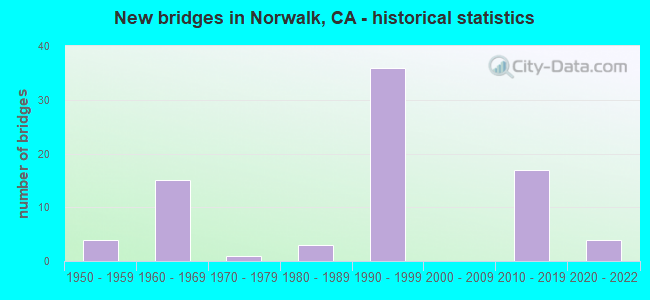
- New bridges - historical statistics
- 41950-1959
- 151960-1969
- 11970-1979
- 31980-1989
- 361990-1999
- 172010-2019
- 42020-2022


- Bridge Condition - Deck
- 89.2%Good
- 10.8%Fair

- Bridge Condition - Channel
- 20.0%Excellent
- 60.0%Very good
- 20.0%Fair

- Bridge Condition - Culverts
- 25.0%Very good
- 75.0%Good
Find on map >> Show street view
Structure Number: 53 1049, Location: 07-LA-005-4.87-NRW (Lat: 33.916558, Lng: -118.079314), Route carried "on" structure: Interstate 5, Year Built: 1954, Status: Open, Structure Length: 1.80m (5.91ft), Average Daily Traffic: 168,000 (year 2009), Average Future Daily Traffic: 263,676 (year 2040), Features Intersected: IMPERIAL HY STORM DRAIN
Minimum Vertical Clearance: 30+ m (98+ ft), Kilometerpoint: 4.870, Lanes on structure: 7, Base Highway Network: Yes (, Subroute: 1), Owner: State Highway Agency, Approaching Roadway Width: 31.7m (104.0ft), Skew: 24 degrees, Material/Design: Concrete, Design/Construction: Culvert, Number Of Spans In Main Unit: 6, Length of Maximum Span: 1.8m (5.9ft), Curb or Sidewalk Widths: Left: 1.4m (4.6ft), Right: 0.0m, Curb-To-Curb Width: 31.7m (104.0ft), Out-to-Out Width: 54.8m (179.8ft)
Condition: Channel: Very good, Culverts: Good, Operating Rating: 54.1 metric tons, Method Used To Determine Operating Rating: Field evaluation and documented engineering judgment, Inventory Rating: 32.4 metric tons, Method Used To Determine Inventory Rating: Field evaluation and documented engineering judgment, Structural Evaluation: Better than present minimum criteria, Deck Geometry: Equal to present minimum criteria, Waterway Adequacy: Superior to present desirable criteria, Approach Roadway Alignment: Superior to present desirable criteria, Designated Inspection Frequency: Every 24 months, Inspection Date: October 2020, Deck Structure Type: Concrete Cast-file-Place
Find on map >> Show street view
Structure Number: 53 164, Location: 07-LA-010-R5.76-LA (Lat: 34.031444, Lng: -118.428033), Route carried "on" structure: Interstate 10, Year Built: 1964, Status: Open, Structure Length: 5.43m (17.81ft), Average Daily Traffic: 258,000 (year 2010), Truck Traffic: 4%, Average Future Daily Traffic: 264,574 (year 2037), Design Load: HS 20, Features Intersected: MILITARY AVE
Minimum Vertical Clearance: 30+ m (98+ ft), Kilometerpoint: 5.760, Lanes on structure: 10, Lanes under structure: 2, Base Highway Network: Yes (, Subroute: 1), Owner: State Highway Agency, Approaching Roadway Width: 50.1m (164.4ft), Skew: 33 degrees, Material/Design: Concrete continuous, Design/Construction: Box Beam or Girders - Multiple, Number Of Spans In Main Unit: 3, Length of Maximum Span: 29.8m (97.8ft), Curb-To-Curb Width: 50.1m (164.4ft), Out-to-Out Width: 50.1m (164.4ft)
Condition: Deck: Fair, Superstructure: Good, Substructure: Good, Operating Rating: 83.6 metric tons, Method Used To Determine Operating Rating: Load Factor (LF), Inventory Rating: 50.2 metric tons, Method Used To Determine Inventory Rating: Load Factor (LF), Structural Evaluation: Better than present minimum criteria, Deck Geometry: Superior to present desirable criteria, Underclear: Equal to present minimum criteria, Approach Roadway Alignment: Superior to present desirable criteria, Designated Inspection Frequency: Every 24 months, Inspection Date: March 2020, Deck Structure Type: Concrete Cast-file-Place
Find on map >> Show street view
Structure Number: 53 1645, Location: 07-LA-605-R5.81-NRW (Lat: 33.887392, Lng: -118.104094), Route carried "on" structure: Interstate 605, Year Built: 1966, Year Reconstructed: 1994, Status: Open, Structure Length: 4.89m (16.04ft), Average Daily Traffic: 297,000 (year 2012), Truck Traffic: 6%, Average Future Daily Traffic: 305,454 (year 2040), Design Load: HS 20, Features Intersected: ALONDRA BLVD
Minimum Vertical Clearance: 30+ m (98+ ft), Kilometerpoint: 5.810, Lanes on structure: 14, Lanes under structure: 6, Base Highway Network: Yes (Inventory Route: 6, Subroute: 3), Owner: State Highway Agency, Approaching Roadway Width: 61.9m (203.1ft), Skew: 30 degrees, Material/Design: Concrete continuous, Design/Construction: Box Beam or Girders - Multiple, Number Of Spans In Main Unit: 4, Length of Maximum Span: 16.2m (53.1ft), Curb-To-Curb Width: 61.9m (203.1ft), Out-to-Out Width: 63.6m (208.7ft)
Condition: Deck: Good, Superstructure: Good, Substructure: Good, Operating Rating: 49.0 metric tons, Method Used To Determine Operating Rating: Load Factor (LF), Inventory Rating: 29.0 metric tons, Method Used To Determine Inventory Rating: Load Factor (LF), Structural Evaluation: Better than present minimum criteria, Deck Geometry: Superior to present desirable criteria, Underclear: Meets minimum limits, Approach Roadway Alignment: Equal to present desirable criteria, Designated Inspection Frequency: Every 24 months, Inspection Date: June 2021, Deck Structure Type: Concrete Cast-file-Place
Find on map >> Show street view
Structure Number: 53 1646, Location: 07-LA-605-R6.32-NRW (Lat: 33.894625, Lng: -118.104522), Route carried "on" structure: Interstate 605, Year Built: 1966, Year Reconstructed: 1993, Status: Open, Structure Length: 3.87m (12.70ft), Average Daily Traffic: 297,000 (year 2012), Truck Traffic: 6%, Average Future Daily Traffic: 305,454 (year 2040), Design Load: HS 20, Features Intersected: FAIRTON STREET
Minimum Vertical Clearance: 30+ m (98+ ft), Kilometerpoint: 6.320, Lanes on structure: 14, Lanes under structure: 2, Base Highway Network: Yes (Inventory Route: 6, Subroute: 3), Owner: State Highway Agency, Approaching Roadway Width: 55.4m (181.8ft), Skew: 30 degrees, Material/Design: Concrete continuous, Design/Construction: Box Beam or Girders - Multiple, Number Of Spans In Main Unit: 3, Length of Maximum Span: 20.7m (67.9ft), Curb-To-Curb Width: 55.4m (181.8ft), Out-to-Out Width: 57.2m (187.7ft)
Condition: Deck: Good, Superstructure: Good, Substructure: Good, Operating Rating: 53.5 metric tons, Method Used To Determine Operating Rating: Load Factor (LF), Inventory Rating: 32.6 metric tons, Method Used To Determine Inventory Rating: Load Factor (LF), Structural Evaluation: Better than present minimum criteria, Deck Geometry: Meets minimum limits, Underclear: Better than present minimum criteria, Approach Roadway Alignment: Superior to present desirable criteria, Designated Inspection Frequency: Every 24 months, Inspection Date: June 2021, Deck Structure Type: Concrete Cast-file-Place
Find on map >> Show street view
Structure Number: 53 1647, Location: 07-LA-605-R6.40-NRW (Lat: 33.895736, Lng: -118.104567), Route carried "on" structure: Interstate 605, Year Built: 1966, Year Reconstructed: 1993, Status: Open, Structure Length: 5.41m (17.75ft), Average Daily Traffic: 297,000 (year 2012), Truck Traffic: 6%, Average Future Daily Traffic: 305,454 (year 2040), Design Load: HS 20, Features Intersected: EXCELSIOR DRIVE
Minimum Vertical Clearance: 30+ m (98+ ft), Kilometerpoint: 6.400, Lanes on structure: 14, Lanes under structure: 4, Base Highway Network: Yes (Inventory Route: 6, Subroute: 3), Owner: State Highway Agency, Approaching Roadway Width: 55.4m (181.8ft), Skew: 33 degrees, Material/Design: Concrete continuous, Design/Construction: Box Beam or Girders - Multiple, Number Of Spans In Main Unit: 4, Length of Maximum Span: 16.2m (53.1ft), Curb-To-Curb Width: 55.4m (181.8ft), Out-to-Out Width: 57.1m (187.3ft)
Condition: Deck: Good, Superstructure: Good, Substructure: Good, Operating Rating: 53.5 metric tons, Method Used To Determine Operating Rating: Load Factor (LF), Inventory Rating: 32.6 metric tons, Method Used To Determine Inventory Rating: Load Factor (LF), Structural Evaluation: Better than present minimum criteria, Deck Geometry: Meets minimum limits, Underclear: Somewhat better than minimum adequacy, Approach Roadway Alignment: Superior to present desirable criteria, Designated Inspection Frequency: Every 24 months, Inspection Date: June 2021, Deck Structure Type: Concrete Cast-file-Place
Find on map >> Show street view
Structure Number: 53 1648, Location: 07-LA-605-R6.81-NRW (Lat: 33.901867, Lng: -118.105011), Route carried "on" structure: Interstate 605, Year Built: 1966, Year Reconstructed: 1993, Status: Open, Structure Length: 4.85m (15.91ft), Average Daily Traffic: 297,000 (year 2012), Truck Traffic: 6%, Average Future Daily Traffic: 305,454 (year 2040), Design Load: HS 20, Features Intersected: ROSECRANS AVE
Minimum Vertical Clearance: 30+ m (98+ ft), Kilometerpoint: 6.810, Lanes on structure: 12, Lanes under structure: 6, Base Highway Network: Yes (Inventory Route: 6, Subroute: 3), Owner: State Highway Agency, Approaching Roadway Width: 50.5m (165.7ft), Skew: 30 degrees, Material/Design: Concrete continuous, Design/Construction: Box Beam or Girders - Multiple, Number Of Spans In Main Unit: 4, Number Of Approach Spans: 4, Length of Maximum Span: 16.2m (53.1ft), Curb-To-Curb Width: 50.5m (165.7ft), Out-to-Out Width: 58.6m (192.3ft)
Condition: Deck: Good, Superstructure: Good, Substructure: Good, Operating Rating: 67.4 metric tons, Method Used To Determine Operating Rating: Load Factor (LF), Inventory Rating: 40.5 metric tons, Method Used To Determine Inventory Rating: Load Factor (LF), Structural Evaluation: Better than present minimum criteria, Deck Geometry: Better than present minimum criteria, Underclear: Meets minimum limits, Approach Roadway Alignment: Superior to present desirable criteria, Designated Inspection Frequency: Every 24 months, Inspection Date: August 2021, Deck Structure Type: Concrete Cast-file-Place
Find on map >> Show street view
Structure Number: 53 1651, Location: 07-LA-605-R7.85-NRW (Lat: 33.916883, Lng: -118.104431), Route carried "on" structure: Interstate 605, Year Built: 1966, Status: Open, Structure Length: 5.00m (16.40ft), Average Daily Traffic: 297,000 (year 2012), Truck Traffic: 6%, Average Future Daily Traffic: 305,454 (year 2042), Design Load: HS 20, Features Intersected: IMPERIAL HIGHWAY
Minimum Vertical Clearance: 30+ m (98+ ft), Kilometerpoint: 7.850, Lanes on structure: 12, Lanes under structure: 6, Base Highway Network: Yes (Inventory Route: 6, Subroute: 3), Owner: State Highway Agency, Approaching Roadway Width: 50.6m (166.0ft), Skew: 30 degrees, Material/Design: Concrete continuous, Design/Construction: Box Beam or Girders - Multiple, Number Of Spans In Main Unit: 4, Length of Maximum Span: 16.2m (53.1ft), Curb-To-Curb Width: 50.6m (166.0ft), Out-to-Out Width: 52.2m (171.3ft)
Condition: Deck: Fair, Superstructure: Good, Substructure: Good, Operating Rating: 37.9 metric tons, Method Used To Determine Operating Rating: Load and Resistance Factor Rating (LRFR) rating reported by rating factor(RF) method using HL-93 loadings, Inventory Rating: 29.2 metric tons, Method Used To Determine Inventory Rating: Load and Resistance Factor Rating (LRFR) rating reported by rating factor(RF) method using HL-93 loadings, Structural Evaluation: Better than present minimum criteria, Deck Geometry: Better than present minimum criteria, Underclear: Meets minimum limits, Approach Roadway Alignment: Superior to present desirable criteria, Designated Inspection Frequency: Every 24 months, Inspection Date: August 2021, Deck Structure Type: Concrete Cast-file-Place
Find on map >> Show street view
Structure Number: 53 1651K, Location: 07-LA-605-R7.85-NRW (Lat: 33.916889, Lng: -118.105092), Route carried "on" structure: Ramp Interstate 605, Year Built: 1993, Status: Open, Structure Length: 4.75m (15.58ft), Average Daily Traffic: 26,260 (year 2012), Truck Traffic: 6%, Average Future Daily Traffic: 30,909 (year 2042), Design Load: HS 20+Mod, Features Intersected: IMPERIAL HIGHWAY
Minimum Vertical Clearance: 30+ m (98+ ft), Kilometerpoint: 7.850, Lanes on structure: 2, Lanes under structure: 6, Base Highway Network: Yes (Inventory Route: 6, Subroute: 1), Owner: State Highway Agency, Approaching Roadway Width: 9.8m (32.2ft), Material/Design: Prestressed concrete continuous, Design/Construction: Box Beam or Girders - Multiple, Number Of Spans In Main Unit: 2, Length of Maximum Span: 24.1m (79.1ft), Curb-To-Curb Width: 9.8m (32.2ft), Out-to-Out Width: 10.8m (35.4ft)
Condition: Deck: Good, Superstructure: Good, Substructure: Good, Operating Rating: 54.1 metric tons, Method Used To Determine Operating Rating: Assigned rating based on Load Factor Design (LFD) reported in metric tons, Inventory Rating: 32.4 metric tons, Method Used To Determine Inventory Rating: Assigned rating based on Load Factor Design (LFD) reported in metric tons, Structural Evaluation: Better than present minimum criteria, Deck Geometry: Equal to present minimum criteria, Underclear: Meets minimum limits, Approach Roadway Alignment: Superior to present desirable criteria, Designated Inspection Frequency: Every 24 months, Inspection Date: August 2021, Deck Structure Type: Concrete Cast-file-Place
Find on map >> Show street view
Structure Number: 53 1651T, Location: 07-LA-605-R7.84-NRW (Lat: 33.915864, Lng: -118.104033), Route carried "on" structure: Ramp Interstate 605, Year Built: 1993, Status: Open, Structure Length: 17.22m (56.50ft), Average Daily Traffic: 8,100 (year 2012), Truck Traffic: 2%, Average Future Daily Traffic: 9,492 (year 2039), Design Load: HS 20+Mod, Features Intersected: IMPERIAL HWY, ON-RAMP
Minimum Vertical Clearance: 30+ m (98+ ft), Kilometerpoint: 7.840, Lanes on structure: 1, Lanes under structure: 8, Base Highway Network: Yes (Inventory Route: 6, Subroute: 1), Owner: State Highway Agency, Approaching Roadway Width: 7.3m (24.0ft), Material/Design: Prestressed concrete continuous, Design/Construction: Box Beam or Girders - Multiple, Number Of Spans In Main Unit: 6, Length of Maximum Span: 33.8m (110.9ft), Curb-To-Curb Width: 7.3m (24.0ft), Out-to-Out Width: 8.4m (27.6ft)
Condition: Deck: Good, Superstructure: Good, Substructure: Good, Operating Rating: 54.1 metric tons, Method Used To Determine Operating Rating: Assigned rating based on Load Factor Design (LFD) reported in metric tons, Inventory Rating: 32.4 metric tons, Method Used To Determine Inventory Rating: Assigned rating based on Load Factor Design (LFD) reported in metric tons, Structural Evaluation: Better than present minimum criteria, Deck Geometry: Better than present minimum criteria, Underclear: Somewhat better than minimum adequacy, Approach Roadway Alignment: Superior to present desirable criteria, Designated Inspection Frequency: Every 24 months, Inspection Date: August 2021, Deck Structure Type: Concrete Cast-file-Place
Find on map >> Show street view
Structure Number: 53 1652, Location: 07-LA-605-R8.23-NRW (Lat: 33.922400, Lng: -118.104153), Route carried "on" structure: Interstate 605, Year Built: 1966, Year Reconstructed: 1993, Status: Open, Structure Length: 13.20m (43.31ft), Average Daily Traffic: 297,000 (year 2012), Truck Traffic: 6%, Average Future Daily Traffic: 305,454 (year 2040), Design Load: HS 20, Features Intersected: UP RR, DOWNEY-NORWALK RD
Minimum Vertical Clearance: 30+ m (98+ ft), Kilometerpoint: 8.230, Lanes on structure: 14, Lanes under structure: 2, Base Highway Network: Yes (Inventory Route: 6, Subroute: 3), Owner: State Highway Agency, Approaching Roadway Width: 62.4m (204.7ft), Skew: 39 degrees, Material/Design: Concrete continuous, Design/Construction: Box Beam or Girders - Multiple, Number Of Spans In Main Unit: 8, Length of Maximum Span: 21.7m (71.2ft), Curb-To-Curb Width: 62.4m (204.7ft), Out-to-Out Width: 63.9m (209.6ft)
Condition: Deck: Good, Superstructure: Good, Substructure: Good, Operating Rating: 68.7 metric tons, Method Used To Determine Operating Rating: Assigned rating based on Load Factor Design (LFD) reported in metric tons, Inventory Rating: 41.5 metric tons, Method Used To Determine Inventory Rating: Assigned rating based on Load Factor Design (LFD) reported in metric tons, Structural Evaluation: Better than present minimum criteria, Deck Geometry: Superior to present desirable criteria, Underclear: Better than present minimum criteria, Approach Roadway Alignment: Superior to present desirable criteria, Designated Inspection Frequency: Every 24 months, Inspection Date: August 2021, Deck Structure Type: Concrete Cast-file-Place
Find on map >> Show street view
Structure Number: 53 1652K, Location: 07-LA-605-R8.23-NRW (Lat: 33.922394, Lng: -118.104978), Route carried "on" structure: Ramp Interstate 605, Year Built: 1993, Status: Open, Structure Length: 13.90m (45.60ft), Average Daily Traffic: 2,600 (year 2012), Truck Traffic: 1%, Average Future Daily Traffic: 3,289 (year 2040), Design Load: HS 20+Mod, Features Intersected: UP RR, DOWNEY-NORWALK RD
Minimum Vertical Clearance: 30+ m (98+ ft), Kilometerpoint: 8.230, Lanes on structure: 2, Lanes under structure: 2, Base Highway Network: Yes, Owner: State Highway Agency, Approaching Roadway Width: 9.8m (32.2ft), Material/Design: Prestressed concrete continuous, Design/Construction: Box Beam or Girders - Multiple, Number Of Spans In Main Unit: 4, Length of Maximum Span: 35.4m (116.1ft), Curb-To-Curb Width: 9.8m (32.2ft), Out-to-Out Width: 10.8m (35.4ft)
Condition: Deck: Good, Superstructure: Good, Substructure: Good, Operating Rating: 54.1 metric tons, Method Used To Determine Operating Rating: Assigned rating based on Load Factor Design (LFD) reported in metric tons, Inventory Rating: 32.4 metric tons, Method Used To Determine Inventory Rating: Assigned rating based on Load Factor Design (LFD) reported in metric tons, Structural Evaluation: Better than present minimum criteria, Deck Geometry: Equal to present minimum criteria, Underclear: Somewhat better than minimum adequacy, Approach Roadway Alignment: Somewhat better than minimum adequacy, Designated Inspection Frequency: Every 24 months, Inspection Date: August 2021, Deck Structure Type: Concrete Cast-file-Place
Find on map >> Show street view
Structure Number: 53 1652S, Location: 07-LA-605-R8.23-NRW (Lat: 33.922397, Lng: -118.103936), Route carried "on" structure: Ramp Interstate 605, Year Built: 1990, Status: Open, Structure Length: 8.96m (29.40ft), Average Daily Traffic: 2,600 (year 2012), Truck Traffic: 1%, Average Future Daily Traffic: 2,976 (year 2040), Design Load: HS 20+Mod, Features Intersected: UP RR, DOWNEY-NORWALK RD
Minimum Vertical Clearance: 30+ m (98+ ft), Kilometerpoint: 8.230, Lanes on structure: 2, Lanes under structure: 2, Base Highway Network: Yes, Owner: State Highway Agency, Approaching Roadway Width: 9.8m (32.2ft), Material/Design: Prestressed concrete continuous, Design/Construction: Box Beam or Girders - Multiple, Number Of Spans In Main Unit: 4, Length of Maximum Span: 30.7m (100.7ft), Curb-To-Curb Width: 9.8m (32.2ft), Out-to-Out Width: 10.8m (35.4ft)
Condition: Deck: Good, Superstructure: Good, Substructure: Good, Operating Rating: 54.1 metric tons, Method Used To Determine Operating Rating: Assigned rating based on Load Factor Design (LFD) reported in metric tons, Inventory Rating: 32.4 metric tons, Method Used To Determine Inventory Rating: Assigned rating based on Load Factor Design (LFD) reported in metric tons, Structural Evaluation: Better than present minimum criteria, Deck Geometry: Equal to present minimum criteria, Underclear: Equal to present minimum criteria, Approach Roadway Alignment: Superior to present desirable criteria, Designated Inspection Frequency: Every 24 months, Inspection Date: August 2021, Deck Structure Type: Concrete Cast-file-Place
Find on map >> Show street view
Structure Number: 53 1653, Location: 07-LA-605-R8.38-NRW (Lat: 33.924317, Lng: -118.103878), Route carried "on" structure: Interstate 605, Year Built: 1966, Year Reconstructed: 1992, Status: Open, Structure Length: 5.80m (19.03ft), Average Daily Traffic: 298,000 (year 2012), Average Future Daily Traffic: 276,624 (year 2039), Design Load: HS 20, Features Intersected: FIRESTONE BLVD
Minimum Vertical Clearance: 30+ m (98+ ft), Kilometerpoint: 8.380, Lanes on structure: 14, Lanes under structure: 6, Base Highway Network: Yes (Inventory Route: 6, Subroute: 3), Owner: State Highway Agency, Approaching Roadway Width: 58.0m (190.3ft), Skew: 32 degrees, Material/Design: Concrete continuous, Design/Construction: Box Beam or Girders - Multiple, Number Of Spans In Main Unit: 2, Length of Maximum Span: 29.1m (95.5ft), Curb-To-Curb Width: 58.0m (190.3ft), Out-to-Out Width: 59.7m (195.9ft)
Condition: Deck: Good, Superstructure: Good, Substructure: Good, Operating Rating: 54.1 metric tons, Method Used To Determine Operating Rating: Assigned rating based on Load Factor Design (LFD) reported in metric tons, Inventory Rating: 32.4 metric tons, Method Used To Determine Inventory Rating: Assigned rating based on Load Factor Design (LFD) reported in metric tons, Structural Evaluation: Better than present minimum criteria, Deck Geometry: Better than present minimum criteria, Underclear: Somewhat better than minimum adequacy, Approach Roadway Alignment: Equal to present desirable criteria, Designated Inspection Frequency: Every 24 months, Inspection Date: September 2021, Deck Structure Type: Concrete Cast-file-Place
Find on map >> Show street view
Structure Number: 53 1653S, Location: 07-LA-605-R8.37-NRW (Lat: 33.924200, Lng: -118.103742), Route carried "on" structure: Ramp Interstate 605, Year Built: 1993, Status: Open, Structure Length: 7.15m (23.46ft), Average Daily Traffic: 254,500 (year 2012), Truck Traffic: 1%, Average Future Daily Traffic: 283,238 (year 2042), Design Load: HS 20+Mod, Features Intersected: FIRESTONE BLVD
Minimum Vertical Clearance: 30+ m (98+ ft), Kilometerpoint: 8.370, Lanes on structure: 2, Lanes under structure: 6, Base Highway Network: Yes (Inventory Route: 6, Subroute: 1), Owner: State Highway Agency, Approaching Roadway Width: 9.8m (32.2ft), Material/Design: Prestressed concrete continuous, Design/Construction: Box Beam or Girders - Multiple, Number Of Spans In Main Unit: 3, Length of Maximum Span: 40.4m (132.5ft), Curb-To-Curb Width: 9.8m (32.2ft), Out-to-Out Width: 10.8m (35.4ft)
Condition: Deck: Good, Superstructure: Good, Substructure: Good, Operating Rating: 54.1 metric tons, Method Used To Determine Operating Rating: Assigned rating based on Load Factor Design (LFD) reported in metric tons, Inventory Rating: 32.4 metric tons, Method Used To Determine Inventory Rating: Assigned rating based on Load Factor Design (LFD) reported in metric tons, Structural Evaluation: Better than present minimum criteria, Deck Geometry: Equal to present minimum criteria, Underclear: Meets minimum limits, Approach Roadway Alignment: Equal to present desirable criteria, Designated Inspection Frequency: Every 24 months, Inspection Date: August 2021, Deck Structure Type: Concrete Cast-file-Place
Find on map >> Show street view
Structure Number: 53 1654, Location: 07-LA-605-R8.91-NRW (Lat: 33.931858, Lng: -118.101167), Route carried "on" structure: Interstate 605, Year Built: 1966, Year Reconstructed: 1985, Status: Open, Structure Length: 3.81m (12.50ft), Average Daily Traffic: 298,000 (year 2012), Truck Traffic: 6%, Average Future Daily Traffic: 276,624 (year 2039), Design Load: HS 20, Features Intersected: CECILIA STREET
Minimum Vertical Clearance: 30+ m (98+ ft), Kilometerpoint: 8.910, Lanes on structure: 13, Lanes under structure: 2, Base Highway Network: Yes (Inventory Route: 6, Subroute: 3), Owner: State Highway Agency, Approaching Roadway Width: 51.8m (169.9ft), Skew: 32 degrees, Material/Design: Concrete continuous, Design/Construction: Box Beam or Girders - Multiple, Number Of Spans In Main Unit: 3, Length of Maximum Span: 20.4m (66.9ft), Curb-To-Curb Width: 51.8m (169.9ft), Out-to-Out Width: 58.4m (191.6ft)
Condition: Deck: Good, Superstructure: Good, Substructure: Good, Operating Rating: 92.0 metric tons, Method Used To Determine Operating Rating: Assigned rating based on Load Factor Design (LFD) reported in metric tons, Inventory Rating: 55.4 metric tons, Method Used To Determine Inventory Rating: Assigned rating based on Load Factor Design (LFD) reported in metric tons, Structural Evaluation: Better than present minimum criteria, Deck Geometry: Meets minimum limits, Underclear: Equal to present minimum criteria, Approach Roadway Alignment: Superior to present desirable criteria, Designated Inspection Frequency: Every 24 months, Inspection Date: September 2021, Deck Structure Type: Concrete Cast-file-Place
Find on map >> Show street view
Structure Number: 53 2594S, Location: 07-LA-605-R7.61-NRW (Lat: 33.913689, Lng: -118.104381), Route carried "on" structure: Bypass Interstate 605, Year Built: 1993, Status: Open, Structure Length: 8.20m (26.90ft), Average Daily Traffic: 8,500 (year 2012), Truck Traffic: 2%, Average Future Daily Traffic: 9,908 (year 2042), Design Load: HS 20+Mod, Features Intersected: ROUTE 105 & LRT
Minimum Vertical Clearance: 30+ m (98+ ft), Kilometerpoint: 7.610, Lanes on structure: 2, Lanes under structure: 6, Base Highway Network: Yes (Inventory Route: 6, Subroute: 1), Owner: State Highway Agency, Approaching Roadway Width: 9.8m (32.2ft), Material/Design: Prestressed concrete continuous, Design/Construction: Box Beam or Girders - Multiple, Number Of Spans In Main Unit: 2, Number Of Approach Spans: 36, Length of Maximum Span: 45.3m (148.6ft), Curb-To-Curb Width: 9.8m (32.2ft), Out-to-Out Width: 10.8m (35.4ft)
Condition: Deck: Good, Superstructure: Good, Substructure: Good, Operating Rating: 54.1 metric tons, Method Used To Determine Operating Rating: Assigned rating based on Load Factor Design (LFD) reported in metric tons, Inventory Rating: 32.4 metric tons, Method Used To Determine Inventory Rating: Assigned rating based on Load Factor Design (LFD) reported in metric tons, Structural Evaluation: Better than present minimum criteria, Deck Geometry: Meets minimum limits, Underclear: High priority of corrective action, Approach Roadway Alignment: Equal to present desirable criteria, Designated Inspection Frequency: Every 24 months, Inspection Date: August 2021, Deck Structure Type: Concrete Cast-file-Place
Find on map >> Show street view
Structure Number: 53 2690G, Location: 07-LA-002-R23.00-GNDL (Lat: 34.205217, Lng: -118.217533), Route carried "on" structure: Ramp State highway 2, Year Built: 1972, Status: Open, Structure Length: 10.12m (33.20ft), Average Daily Traffic: 8,900 (year 2014), Truck Traffic: 4%, Average Future Daily Traffic: 12,445 (year 2044), Design Load: HS 20, Features Intersected: VERDUGO BLVD
Minimum Vertical Clearance: 30+ m (98+ ft), Kilometerpoint: 23.000, Lanes on structure: 2, Lanes under structure: 5, Base Highway Network: Yes (, Subroute: 1), Owner: State Highway Agency, Approaching Roadway Width: 11.9m (39.0ft), Skew: 3 degrees, Material/Design: Concrete continuous, Design/Construction: Box Beam or Girders - Multiple, Number Of Spans In Main Unit: 3, Length of Maximum Span: 44.8m (147.0ft), Curb-To-Curb Width: 11.9m (39.0ft), Out-to-Out Width: 12.5m (41.0ft)
Condition: Deck: Fair, Superstructure: Good, Substructure: Good, Operating Rating: 99.8 metric tons, Method Used To Determine Operating Rating: Load Factor (LF), Inventory Rating: 62.2 metric tons, Method Used To Determine Inventory Rating: Load Factor (LF), Structural Evaluation: Better than present minimum criteria, Deck Geometry: Superior to present desirable criteria, Underclear: Somewhat better than minimum adequacy, Approach Roadway Alignment: Equal to present desirable criteria, Designated Inspection Frequency: Every 24 months, Inspection Date: January 2022, Deck Structure Type: Concrete Cast-file-Place
Find on map >> Show street view
Structure Number: 53 2697H, Location: 07-LA-605-R7.66-NRW (Lat: 33.914083, Lng: -118.111683), Route carried "on" structure: Ramp Interstate 605, Year Built: 1993, Status: Open, Structure Length: 11.57m (37.96ft), Average Daily Traffic: 25,450 (year 2012), Truck Traffic: 2%, Average Future Daily Traffic: 27,218 (year 2042), Design Load: HS 20+Mod, Features Intersected: SAN GABRIEL RV/SERVICE R
Minimum Vertical Clearance: 30+ m (98+ ft), Kilometerpoint: 7.660, Lanes on structure: 4, Base Highway Network: Yes (Inventory Route: 6, Subroute: 1), Owner: State Highway Agency, Approaching Roadway Width: 19.1m (62.7ft), Material/Design: Prestressed concrete continuous, Design/Construction: Box Beam or Girders - Multiple, Number Of Spans In Main Unit: 3, Length of Maximum Span: 45.3m (148.6ft), Curb-To-Curb Width: 19.1m (62.7ft), Out-to-Out Width: 20.1m (65.9ft)
Condition: Deck: Good, Superstructure: Good, Substructure: Good, Channel: Excellent, Operating Rating: 54.1 metric tons, Method Used To Determine Operating Rating: Assigned rating based on Load Factor Design (LFD) reported in metric tons, Inventory Rating: 32.4 metric tons, Method Used To Determine Inventory Rating: Assigned rating based on Load Factor Design (LFD) reported in metric tons, Structural Evaluation: Better than present minimum criteria, Deck Geometry: Superior to present desirable criteria, Waterway Adequacy: Superior to present desirable criteria, Approach Roadway Alignment: Equal to present desirable criteria, Designated Inspection Frequency: Every 24 months, Inspection Date: August 2021, Deck Structure Type: Concrete Cast-file-Place
Find on map >> Show street view
Structure Number: 53 2699G, Location: 07-LA-605-R6.81-NRW (Lat: 33.903081, Lng: -118.104703), Route carried "on" structure: Ramp Interstate 605, Year Built: 1993, Status: Open, Structure Length: 13.56m (44.49ft), Average Daily Traffic: 26,260 (year 2012), Truck Traffic: 2%, Average Future Daily Traffic: 31,012 (year 2042), Design Load: HS 20+Mod, Features Intersected: ROSECRANS AVE
Minimum Vertical Clearance: 30+ m (98+ ft), Kilometerpoint: 6.810, Lanes on structure: 3, Lanes under structure: 5, Base Highway Network: Yes (Inventory Route: 6, Subroute: 1), Owner: State Highway Agency, Approaching Roadway Width: 15.0m (49.2ft), Skew: 9 degrees, Material/Design: Prestressed concrete continuous, Design/Construction: Box Beam or Girders - Multiple, Number Of Spans In Main Unit: 3, Length of Maximum Span: 48.8m (160.1ft), Curb-To-Curb Width: 15.0m (49.2ft), Out-to-Out Width: 16.0m (52.5ft)
Condition: Deck: Good, Superstructure: Good, Substructure: Good, Operating Rating: 54.1 metric tons, Method Used To Determine Operating Rating: Assigned rating based on Load Factor Design (LFD) reported in metric tons, Inventory Rating: 32.4 metric tons, Method Used To Determine Inventory Rating: Assigned rating based on Load Factor Design (LFD) reported in metric tons, Structural Evaluation: Better than present minimum criteria, Deck Geometry: Superior to present desirable criteria, Underclear: Meets minimum limits, Approach Roadway Alignment: Better than present minimum criteria, Designated Inspection Frequency: Every 24 months, Inspection Date: August 2021, Deck Structure Type: Concrete Cast-file-Place
Find on map >> Show street view
Structure Number: 53 2702G, Location: 07-LA-105-R17.64-NRW (Lat: 33.913458, Lng: -118.108381), Route carried "on" structure: Interstate 105, Year Built: 1993, Status: Open, Structure Length: 64.53m (211.71ft), Average Daily Traffic: 201,000 (year 2009), Truck Traffic: 9%, Average Future Daily Traffic: 118,714 (year 2042), Design Load: HS 20+Mod, Features Intersected: RMP, CONN, 105, 605, IMP
Minimum Vertical Clearance: 30+ m (98+ ft), Kilometerpoint: 17.640, Lanes on structure: 2, Lanes under structure: 13, Base Highway Network: Yes (Inventory Route: 1, Subroute: 1), Owner: State Highway Agency, Approaching Roadway Width: 11.7m (38.4ft), Material/Design: Prestressed concrete continuous, Design/Construction: Box Beam or Girders - Multiple, Number Of Spans In Main Unit: 12, Length of Maximum Span: 61.0m (200.1ft), Curb-To-Curb Width: 11.7m (38.4ft), Out-to-Out Width: 12.8m (42.0ft)
Condition: Deck: Good, Superstructure: Good, Substructure: Good, Operating Rating: 54.1 metric tons, Method Used To Determine Operating Rating: Assigned rating based on Load Factor Design (LFD) reported in metric tons, Inventory Rating: 32.4 metric tons, Method Used To Determine Inventory Rating: Assigned rating based on Load Factor Design (LFD) reported in metric tons, Structural Evaluation: Better than present minimum criteria, Deck Geometry: Equal to present minimum criteria, Underclear: High priority of corrective action, Approach Roadway Alignment: Equal to present desirable criteria, Designated Inspection Frequency: Every 24 months, Inspection Date: July 2020, Deck Structure Type: Concrete Cast-file-Place
Find on map >> Show street view
Structure Number: 53 2703G, Location: 07-LA-105-R17.77-NRW (Lat: 33.910131, Lng: -118.105486), Route carried "on" structure: Ramp Interstate 105, Year Built: 1993, Status: Open, Structure Length: 6.71m (22.01ft), Average Daily Traffic: 20,500 (year 2010), Truck Traffic: 1%, Average Future Daily Traffic: 22,525 (year 2038), Design Load: HS 20+Mod, Features Intersected: FOSTER ROAD
Minimum Vertical Clearance: 30+ m (98+ ft), Kilometerpoint: 17.770, Lanes on structure: 3, Lanes under structure: 4, Base Highway Network: Yes (Inventory Route: 1, Subroute: 1), Owner: State Highway Agency, Approaching Roadway Width: 18.7m (61.4ft), Material/Design: Concrete continuous, Design/Construction: Box Beam or Girders - Multiple, Number Of Spans In Main Unit: 3, Length of Maximum Span: 23.5m (77.1ft), Curb-To-Curb Width: 18.7m (61.4ft), Out-to-Out Width: 19.7m (64.6ft)
Condition: Deck: Good, Superstructure: Good, Substructure: Good, Operating Rating: 54.1 metric tons, Method Used To Determine Operating Rating: Assigned rating based on Load Factor Design (LFD) reported in metric tons, Inventory Rating: 32.4 metric tons, Method Used To Determine Inventory Rating: Assigned rating based on Load Factor Design (LFD) reported in metric tons, Structural Evaluation: Better than present minimum criteria, Deck Geometry: Superior to present desirable criteria, Underclear: High priority of corrective action, Approach Roadway Alignment: Superior to present desirable criteria, Designated Inspection Frequency: Every 24 months, Inspection Date: July 2020, Deck Structure Type: Concrete Cast-file-Place
Find on map >> Show street view
Structure Number: 53 2704G, Location: 07-LA-105-R17.78-NRW (Lat: 33.907828, Lng: -118.105667), Route carried "on" structure: Ramp Interstate 105, Year Built: 1987, Status: Open, Structure Length: 15.93m (52.26ft), Average Daily Traffic: 20,500 (year 2010), Truck Traffic: 6%, Average Future Daily Traffic: 22,525 (year 2038), Design Load: HS 20+Mod, Features Intersected: S605-ROSECRANS OFFRMP
Minimum Vertical Clearance: 5.18m (16.99ft), Kilometerpoint: 17.780, Lanes on structure: 2, Lanes under structure: 1, Base Highway Network: Yes (Inventory Route: 1, Subroute: 1), Owner: State Highway Agency, Approaching Roadway Width: 11.7m (38.4ft), Material/Design: Prestressed concrete continuous, Design/Construction: Box Beam or Girders - Multiple, Number Of Spans In Main Unit: 4, Length of Maximum Span: 42.7m (140.1ft), Curb-To-Curb Width: 11.7m (38.4ft), Out-to-Out Width: 12.8m (42.0ft)
Condition: Deck: Good, Superstructure: Good, Substructure: Good, Operating Rating: 54.1 metric tons, Method Used To Determine Operating Rating: Assigned rating based on Load Factor Design (LFD) reported in metric tons, Inventory Rating: 32.4 metric tons, Method Used To Determine Inventory Rating: Assigned rating based on Load Factor Design (LFD) reported in metric tons, Structural Evaluation: Better than present minimum criteria, Deck Geometry: Superior to present desirable criteria, Underclear: Superior to present desirable criteria, Approach Roadway Alignment: Better than present minimum criteria, Designated Inspection Frequency: Every 24 months, Inspection Date: July 2020, Deck Structure Type: Concrete Cast-file-Place
Find on map >> Show street view
Structure Number: 53 2705F, Location: 07-LA-605-R8.04-NRW (Lat: 33.919842, Lng: -118.105039), Route carried "on" structure: Ramp Interstate 605, Year Built: 1992, Status: Open, Structure Length: 4.96m (16.27ft), Average Daily Traffic: 26,267 (year 2012), Truck Traffic: 2%, Average Future Daily Traffic: 30,909 (year 2040), Design Load: HS 20+Mod, Features Intersected: FIRESTONE-S605 RMP
Minimum Vertical Clearance: 30+ m (98+ ft), Kilometerpoint: 8.040, Lanes on structure: 3, Lanes under structure: 1, Base Highway Network: Yes (Inventory Route: 6, Subroute: 1), Owner: State Highway Agency, Approaching Roadway Width: 19.3m (63.3ft), Skew: 7 degrees, Material/Design: Concrete, Design/Construction: Slab, Number Of Spans In Main Unit: 1, Length of Maximum Span: 49.6m (162.7ft), Curb-To-Curb Width: 19.3m (63.3ft), Out-to-Out Width: 20.2m (66.3ft)
Condition: Deck: Good, Superstructure: Good, Substructure: Good, Operating Rating: 54.1 metric tons, Method Used To Determine Operating Rating: Assigned rating based on Load Factor Design (LFD) reported in metric tons, Inventory Rating: 32.4 metric tons, Method Used To Determine Inventory Rating: Assigned rating based on Load Factor Design (LFD) reported in metric tons, Structural Evaluation: Better than present minimum criteria, Deck Geometry: Superior to present desirable criteria, Underclear: Equal to present minimum criteria, Approach Roadway Alignment: Superior to present desirable criteria, Designated Inspection Frequency: Every 24 months, Inspection Date: August 2021
Find on map >> Show street view
Structure Number: 53 2706F, Location: 07-LA-605-R7.94-NRW (Lat: 33.916889, Lng: -118.105283), Route carried "on" structure: Ramp Interstate 605, Year Built: 1993, Status: Open, Structure Length: 13.72m (45.01ft), Average Daily Traffic: 24,500 (year 2012), Truck Traffic: 2%, Average Future Daily Traffic: 27,218 (year 2040), Design Load: HS 20+Mod, Features Intersected: IMPERIAL HIGHWAY
Minimum Vertical Clearance: 30+ m (98+ ft), Kilometerpoint: 7.940, Lanes on structure: 2, Lanes under structure: 8, Base Highway Network: Yes (Inventory Route: 6, Subroute: 1), Owner: State Highway Agency, Approaching Roadway Width: 11.7m (38.4ft), Material/Design: Prestressed concrete continuous, Design/Construction: Box Beam or Girders - Multiple, Number Of Spans In Main Unit: 3, Length of Maximum Span: 50.3m (165.0ft), Curb-To-Curb Width: 11.7m (38.4ft), Out-to-Out Width: 12.8m (42.0ft)
Condition: Deck: Good, Superstructure: Good, Substructure: Good, Operating Rating: 54.1 metric tons, Method Used To Determine Operating Rating: Assigned rating based on Load Factor Design (LFD) reported in metric tons, Inventory Rating: 32.4 metric tons, Method Used To Determine Inventory Rating: Assigned rating based on Load Factor Design (LFD) reported in metric tons, Structural Evaluation: Better than present minimum criteria, Deck Geometry: Superior to present desirable criteria, Underclear: Meets minimum limits, Approach Roadway Alignment: Superior to present desirable criteria, Designated Inspection Frequency: Every 24 months, Inspection Date: August 2021, Deck Structure Type: Concrete Cast-file-Place
Find on map >> Show street view
Structure Number: 53 2719G, Location: 07-LA-105-R17.66-NRW (Lat: 33.912678, Lng: -118.106439), Route carried "on" structure: Ramp Interstate 105, Year Built: 1993, Status: Open, Structure Length: 6.25m (20.51ft), Average Daily Traffic: 10,000 (year 2006), Truck Traffic: 2%, Average Future Daily Traffic: 13,360 (year 2042), Design Load: HS 20+Mod, Features Intersected: METRO NORWALK PARKING
Minimum Vertical Clearance: 30+ m (98+ ft), Kilometerpoint: 17.660, Lanes on structure: 2, Base Highway Network: Yes (Inventory Route: 1, Subroute: 1), Owner: State Highway Agency, Approaching Roadway Width: 11.7m (38.4ft), Material/Design: Prestressed concrete continuous, Design/Construction: Box Beam or Girders - Multiple, Number Of Spans In Main Unit: 3, Length of Maximum Span: 25.0m (82.0ft), Curb-To-Curb Width: 11.7m (38.4ft), Out-to-Out Width: 12.8m (42.0ft)
Condition: Deck: Good, Superstructure: Good, Substructure: Good, Operating Rating: 54.1 metric tons, Method Used To Determine Operating Rating: Assigned rating based on Load Factor Design (LFD) reported in metric tons, Inventory Rating: 32.4 metric tons, Method Used To Determine Inventory Rating: Assigned rating based on Load Factor Design (LFD) reported in metric tons, Structural Evaluation: Better than present minimum criteria, Deck Geometry: Superior to present desirable criteria, Approach Roadway Alignment: Equal to present desirable criteria, Designated Inspection Frequency: Every 24 months, Inspection Date: July 2020, Deck Structure Type: Concrete Cast-file-Place
Find on map >> Show street view
Structure Number: 53 2751, Location: 07-LA-110-11.89-LA (Lat: 33.901792, Lng: -118.287083), Route carried "on" structure: City street , Year Built: 1996, Status: Open, Structure Length: 8.04m (26.38ft), Average Daily Traffic: 35,790 (year 2020), Truck Traffic: 1%, Average Future Daily Traffic: 47,605 (year 2037), Design Load: HS 20+Mod, Features Intersected: INTERSTATE 110, Facility Carried by Structure: ROSECRANS AVE
Minimum Vertical Clearance: 30+ m (98+ ft), Kilometerpoint: 0.000, Lanes on structure: 6, Lanes under structure: 11, Base Highway Network: Yes, Owner: State Highway Agency, Approaching Roadway Width: 25.8m (84.6ft), Material/Design: Prestressed concrete continuous, Design/Construction: Box Beam or Girders - Multiple, Number Of Spans In Main Unit: 2, Length of Maximum Span: 42.0m (137.8ft), Curb or Sidewalk Widths: Left: 2.3m (7.5ft), Right: 0.0m, Curb-To-Curb Width: 25.8m (84.6ft), Out-to-Out Width: 31.6m (103.7ft)
Condition: Deck: Good, Superstructure: Good, Substructure: Good, Operating Rating: 54.1 metric tons, Method Used To Determine Operating Rating: Assigned rating based on Load Factor Design (LFD) reported in metric tons, Inventory Rating: 32.4 metric tons, Method Used To Determine Inventory Rating: Assigned rating based on Load Factor Design (LFD) reported in metric tons, Structural Evaluation: Better than present minimum criteria, Deck Geometry: Somewhat better than minimum adequacy, Underclear: Meets minimum limits, Approach Roadway Alignment: Equal to present desirable criteria, Designated Inspection Frequency: Every 24 months, Inspection Date: April 2020, Deck Structure Type: Concrete Cast-file-Place, Wearing Surface/Protective System: Wearing Surface: Monolithic Concrete
Find on map >> Show street view
Structure Number: 53 2759, Location: 07-LA-105-R17.91-NRW (Lat: 33.914019, Lng: -118.103331), Route carried "on" structure: City street , Year Built: 1994, Status: Open, Structure Length: 4.28m (14.04ft), Average Daily Traffic: 1,000 (year 2012), Truck Traffic: 2%, Average Future Daily Traffic: 1,631 (year 2042), Design Load: HS 20+Mod, Features Intersected: ROUTE 105, LRT, Facility Carried by Structure: HOXIE AVE
Minimum Vertical Clearance: 30+ m (98+ ft), Kilometerpoint: 0.000, Lanes on structure: 5, Lanes under structure: 4, Base Highway Network: Yes, Owner: State Highway Agency, Approaching Roadway Width: 18.9m (62.0ft), Material/Design: Prestressed concrete, Design/Construction: Box Beam or Girders - Multiple, Number Of Spans In Main Unit: 1, Length of Maximum Span: 42.8m (140.4ft), Curb or Sidewalk Widths: Left: 1.8m (5.9ft), Right: 1.8m (5.9ft), Curb-To-Curb Width: 18.9m (62.0ft), Out-to-Out Width: 23.2m (76.1ft)
Condition: Deck: Fair, Superstructure: Good, Substructure: Good, Operating Rating: 54.1 metric tons, Method Used To Determine Operating Rating: Assigned rating based on Load Factor Design (LFD) reported in metric tons, Inventory Rating: 32.4 metric tons, Method Used To Determine Inventory Rating: Assigned rating based on Load Factor Design (LFD) reported in metric tons, Structural Evaluation: Better than present minimum criteria, Deck Geometry: Meets minimum limits, Underclear: High priority of corrective action, Approach Roadway Alignment: Equal to present desirable criteria, Designated Inspection Frequency: Every 24 months, Inspection Date: July 2020, Deck Structure Type: Concrete Cast-file-Place
Find on map >> Show street view
Structure Number: 53 3018, Location: 07-LA-005-2.42-NRW (Lat: 33.891722, Lng: -118.046750), Route carried "on" structure: Business City street , Year Built: 2016, Status: Open, Structure Length: 31.85m (104.49ft), Average Daily Traffic: 27,000 (year 2018), Truck Traffic: 5%, Average Future Daily Traffic: 37,800 (year 2041), Design Load: HS 20+Mod, Features Intersected: INTERSTATE 5, Facility Carried by Structure: CARMENITA ROAD
Minimum Vertical Clearance: 30+ m (98+ ft), Kilometerpoint: 0.000, Lanes on structure: 6, Lanes under structure: 10, Base Highway Network: Yes, Owner: State Highway Agency, Approaching Roadway Width: 22.0m (72.2ft), Skew: 39 degrees, Material/Design: Concrete continuous, Design/Construction: Box Beam or Girders - Multiple, Number Of Spans In Main Unit: 6, Number Of Approach Spans: 3, Length of Maximum Span: 48.2m (158.1ft), Curb or Sidewalk Widths: Left: 2.4m (7.9ft), Right: 2.4m (7.9ft), Curb-To-Curb Width: 22.0m (72.2ft), Out-to-Out Width: 39.0m (128.0ft)
Condition: Deck: Good, Superstructure: Good, Substructure: Good, Operating Rating: 54.1 metric tons, Method Used To Determine Operating Rating: Assigned rating based on Load Factor Design (LFD) reported in metric tons, Inventory Rating: 32.4 metric tons, Method Used To Determine Inventory Rating: Assigned rating based on Load Factor Design (LFD) reported in metric tons, Structural Evaluation: Better than present minimum criteria, Deck Geometry: High priority of corrective action, Underclear: Better than present minimum criteria, Approach Roadway Alignment: Equal to present desirable criteria, Designated Inspection Frequency: Every 24 months, Inspection Date: March 2020, Deck Structure Type: Concrete Cast-file-Place
Find on map >> Show street view
Structure Number: 53 3018K, Location: 07-LA-005-2.45-NRW (Lat: 33.893597, Lng: -118.047511), Route carried "on" structure: Ramp Interstate 5, Year Built: 2016, Status: Open, Structure Length: 11.57m (37.96ft), Average Daily Traffic: 9,870 (year 2015), Truck Traffic: 5%, Average Future Daily Traffic: 13,818 (year 2037), Design Load: HS 20+Mod, Features Intersected: GRADED EARTH
Minimum Vertical Clearance: 30+ m (98+ ft), Kilometerpoint: 2.450, Lanes on structure: 2, Owner: State Highway Agency, Approaching Roadway Width: 11.4m (37.4ft), Material/Design: Concrete continuous, Design/Construction: Box Beam or Girders - Multiple, Number Of Spans In Main Unit: 4, Length of Maximum Span: 32.9m (107.9ft), Curb-To-Curb Width: 11.4m (37.4ft), Out-to-Out Width: 12.3m (40.4ft)
Condition: Deck: Good, Superstructure: Good, Substructure: Good, Operating Rating: 54.1 metric tons, Method Used To Determine Operating Rating: Assigned rating based on Load Factor Design (LFD) reported in metric tons, Inventory Rating: 32.4 metric tons, Method Used To Determine Inventory Rating: Assigned rating based on Load Factor Design (LFD) reported in metric tons, Structural Evaluation: Better than present minimum criteria, Deck Geometry: Superior to present desirable criteria, Approach Roadway Alignment: Equal to present desirable criteria, Designated Inspection Frequency: Every 24 months, Inspection Date: March 2020, Deck Structure Type: Concrete Cast-file-Place
Find on map >> Show street view
Structure Number: 53 3018S, Location: 07-LA-005-2.48-NRW (Lat: 33.894617, Lng: -118.047306), Route carried "on" structure: Ramp Interstate 5, Year Built: 2016, Status: Open, Structure Length: 7.89m (25.89ft), Average Daily Traffic: 3,670 (year 2015), Truck Traffic: 5%, Average Future Daily Traffic: 5,138 (year 2041), Design Load: HS 20+Mod, Features Intersected: GRADED EARTH
Minimum Vertical Clearance: 30+ m (98+ ft), Kilometerpoint: 2.480, Lanes on structure: 2, Owner: State Highway Agency, Approaching Roadway Width: 10.8m (35.4ft), Material/Design: Concrete continuous, Design/Construction: Box Beam or Girders - Multiple, Number Of Spans In Main Unit: 3, Length of Maximum Span: 31.0m (101.7ft), Curb-To-Curb Width: 10.8m (35.4ft), Out-to-Out Width: 11.7m (38.4ft)
Condition: Deck: Good, Superstructure: Good, Substructure: Good, Operating Rating: 54.1 metric tons, Method Used To Determine Operating Rating: Assigned rating based on Load Factor Design (LFD) reported in metric tons, Inventory Rating: 32.4 metric tons, Method Used To Determine Inventory Rating: Assigned rating based on Load Factor Design (LFD) reported in metric tons, Structural Evaluation: Better than present minimum criteria, Deck Geometry: Better than present minimum criteria, Approach Roadway Alignment: Equal to present desirable criteria, Designated Inspection Frequency: Every 24 months, Inspection Date: March 2020, Deck Structure Type: Concrete Cast-file-Place
Find on map >> Show street view
Structure Number: 53 3019K, Location: 07-LA-005-2.33-NRW (Lat: 33.892578, Lng: -118.045697), Route carried "on" structure: Ramp Interstate 5, Year Built: 2016, Status: Open, Structure Length: 8.30m (27.23ft), Average Daily Traffic: 5,400 (year 2016), Truck Traffic: 5%, Average Future Daily Traffic: 7,560 (year 2041), Design Load: HS 20+Mod, Features Intersected: GRADED EARTH
Minimum Vertical Clearance: 30+ m (98+ ft), Kilometerpoint: 2.330, Lanes on structure: 2, Owner: State Highway Agency, Approaching Roadway Width: 11.4m (37.4ft), Material/Design: Concrete continuous, Design/Construction: Box Beam or Girders - Multiple, Number Of Spans In Main Unit: 3, Length of Maximum Span: 33.0m (108.3ft), Curb-To-Curb Width: 11.4m (37.4ft), Out-to-Out Width: 12.3m (40.4ft)
Condition: Deck: Good, Superstructure: Good, Substructure: Good, Operating Rating: 54.1 metric tons, Method Used To Determine Operating Rating: Assigned rating based on Load Factor Design (LFD) reported in metric tons, Inventory Rating: 32.4 metric tons, Method Used To Determine Inventory Rating: Assigned rating based on Load Factor Design (LFD) reported in metric tons, Structural Evaluation: Better than present minimum criteria, Deck Geometry: Superior to present desirable criteria, Approach Roadway Alignment: Equal to present desirable criteria, Designated Inspection Frequency: Every 24 months, Inspection Date: March 2020, Deck Structure Type: Concrete Cast-file-Place
Find on map >> Show street view
Structure Number: 53 3019S, Location: 07-LA-005-2.37-NRW (Lat: 33.893797, Lng: -118.045819), Route carried "on" structure: Ramp Interstate 5, Year Built: 2016, Status: Open, Structure Length: 6.10m (20.01ft), Average Daily Traffic: 6,390 (year 2016), Truck Traffic: 5%, Average Future Daily Traffic: 8,946 (year 2037), Design Load: HS 20+Mod, Features Intersected: GRADED EARTH
Minimum Vertical Clearance: 30+ m (98+ ft), Kilometerpoint: 2.370, Lanes on structure: 3, Owner: State Highway Agency, Approaching Roadway Width: 15.0m (49.2ft), Material/Design: Concrete continuous, Design/Construction: Box Beam or Girders - Multiple, Number Of Spans In Main Unit: 3, Length of Maximum Span: 25.0m (82.0ft), Curb-To-Curb Width: 15.0m (49.2ft), Out-to-Out Width: 15.9m (52.2ft)
Condition: Deck: Good, Superstructure: Good, Substructure: Good, Operating Rating: 54.1 metric tons, Method Used To Determine Operating Rating: Assigned rating based on Load Factor Design (LFD) reported in metric tons, Inventory Rating: 32.4 metric tons, Method Used To Determine Inventory Rating: Assigned rating based on Load Factor Design (LFD) reported in metric tons, Structural Evaluation: Better than present minimum criteria, Deck Geometry: Superior to present desirable criteria, Approach Roadway Alignment: Equal to present desirable criteria, Designated Inspection Frequency: Every 48 months, Inspection Date: March 2020, Deck Structure Type: Concrete Cast-file-Place
Find on map >> Show street view
Structure Number: 53 3033, Location: 07-LA-047-3.74-LBCH (Lat: 33.762222, Lng: -118.238694), Route carried "on" structure: State highway 47, Year Built: 2015, Status: Open, Structure Length: 12.01m (39.40ft), Average Daily Traffic: 11,000 (year 2021), Truck Traffic: 19%, Average Future Daily Traffic: 30,319 (year 2042), Design Load: HL 93, Features Intersected: OPEN GROUND., Facility Carried by Structure: DOCK ST. ON-RAMP
Minimum Vertical Clearance: 30+ m (98+ ft), Kilometerpoint: 3.740, Lanes on structure: 1, Base Highway Network: Yes (, Subroute: 1), Owner: State Highway Agency, Approaching Roadway Width: 11.9m (39.0ft), Material/Design: Concrete continuous, Design/Construction: Box Beam or Girders - Single/Spread, Number Of Spans In Main Unit: 3, Length of Maximum Span: 45.7m (149.9ft), Curb-To-Curb Width: 7.3m (24.0ft), Out-to-Out Width: 7.3m (24.0ft)
Condition: Deck: Good, Superstructure: Good, Substructure: Good, Operating Rating: 42.1 metric tons, Method Used To Determine Operating Rating: Assigned ratings based on Load and Resistance Factor Design (LRFD) reported by rating factor (RF) using HL93 loadings, Inventory Rating: 32.4 metric tons, Method Used To Determine Inventory Rating: Assigned ratings based on Load and Resistance Factor Design (LRFD) reported by rating factor (RF) using HL93 loadings, Structural Evaluation: Better than present minimum criteria, Deck Geometry: High priority of replacement, Approach Roadway Alignment: Equal to present desirable criteria, Designated Inspection Frequency: Every 24 months, Inspection Date: January 2022, Deck Structure Type: Concrete Cast-file-Place
Find on map >> Show street view
Structure Number: 53 3039, Location: 07-LA-005-3.04-NRW (Lat: 33.898222, Lng: -118.055722), Route carried "on" structure: Business City street , Year Built: 2014, Status: Open, Structure Length: 14.33m (47.01ft), Average Daily Traffic: 10,000 (year 2018), Truck Traffic: 2%, Average Future Daily Traffic: 14,000 (year 2037), Design Load: HL 93, Features Intersected: I 5, FIRESTONE BLVD, Facility Carried by Structure: SHOEMAKER AVE
Minimum Vertical Clearance: 30+ m (98+ ft), Kilometerpoint: 0.000, Lanes on structure: 2, Lanes under structure: 15, Owner: State Highway Agency, Approaching Roadway Width: 9.8m (32.2ft), Skew: 3 degrees, Material/Design: Prestressed concrete continuous, Design/Construction: Box Beam or Girders - Multiple, Number Of Spans In Main Unit: 4, Length of Maximum Span: 42.8m (140.4ft), Curb or Sidewalk Widths: Left: 1.8m (5.9ft), Right: 1.8m (5.9ft), Curb-To-Curb Width: 9.8m (32.2ft), Out-to-Out Width: 14.0m (45.9ft)
Condition: Deck: Good, Superstructure: Good, Substructure: Good, Operating Rating: 42.1 metric tons, Method Used To Determine Operating Rating: Assigned ratings based on Load and Resistance Factor Design (LRFD) reported by rating factor (RF) using HL93 loadings, Inventory Rating: 32.4 metric tons, Method Used To Determine Inventory Rating: Assigned ratings based on Load and Resistance Factor Design (LRFD) reported by rating factor (RF) using HL93 loadings, Structural Evaluation: Better than present minimum criteria, Deck Geometry: Meets minimum limits, Underclear: Meets minimum limits, Approach Roadway Alignment: Equal to present desirable criteria, Designated Inspection Frequency: Every 24 months, Inspection Date: March 2020, Deck Structure Type: Concrete Cast-file-Place
Find on map >> Show street view
Structure Number: 53 3041, Location: 07-LA-005-3.68-NRW (Lat: 33.904611, Lng: -118.064319), Route carried "on" structure: Interstate 5, Year Built: 2016, Status: Open, Structure Length: 5.72m (18.77ft), Average Daily Traffic: 175,000 (year 2016), Truck Traffic: 10%, Average Future Daily Traffic: 245,000 (year 2041), Design Load: HL 93, Features Intersected: BLOOMFIELD AVENUE
Minimum Vertical Clearance: 30+ m (98+ ft), Kilometerpoint: 3.680, Lanes on structure: 7, Lanes under structure: 4, Base Highway Network: Yes (, Subroute: 1), Owner: State Highway Agency, Approaching Roadway Width: 65.7m (215.6ft), Skew: 33 degrees, Material/Design: Prestressed concrete continuous, Design/Construction: Box Beam or Girders - Multiple, Number Of Spans In Main Unit: 2, Length of Maximum Span: 28.7m (94.2ft), Curb-To-Curb Width: 65.7m (215.6ft), Out-to-Out Width: 67.2m (220.5ft)
Condition: Deck: Good, Superstructure: Good, Substructure: Good, Operating Rating: 42.1 metric tons, Method Used To Determine Operating Rating: Assigned ratings based on Load and Resistance Factor Design (LRFD) reported by rating factor (RF) using HL93 loadings, Inventory Rating: 32.4 metric tons, Method Used To Determine Inventory Rating: Assigned ratings based on Load and Resistance Factor Design (LRFD) reported by rating factor (RF) using HL93 loadings, Structural Evaluation: Better than present minimum criteria, Deck Geometry: Superior to present desirable criteria, Underclear: High priority of corrective action, Approach Roadway Alignment: Equal to present desirable criteria, Designated Inspection Frequency: Every 24 months, Inspection Date: March 2020, Deck Structure Type: Concrete Cast-file-Place
Find on map >> Show street view
Structure Number: 53 3042K, Location: 07-LA-005-3.63-NRW (Lat: 33.903556, Lng: -118.064194), Route carried "on" structure: Ramp Interstate 5, Year Built: 2015, Status: Open, Structure Length: 6.98m (22.90ft), Average Daily Traffic: 20,000 (year 2018), Average Future Daily Traffic: 28,000 (year 2037), Design Load: HL 93, Features Intersected: BLOOMFIELD AVENUE
Minimum Vertical Clearance: 30+ m (98+ ft), Kilometerpoint: 3.630, Lanes on structure: 2, Lanes under structure: 4, Owner: State Highway Agency, Approaching Roadway Width: 11.6m (38.1ft), Skew: 5 degrees, Material/Design: Prestressed concrete, Design/Construction: Box Beam or Girders - Multiple, Number Of Spans In Main Unit: 1, Length of Maximum Span: 68.2m (223.8ft), Curb-To-Curb Width: 11.6m (38.1ft), Out-to-Out Width: 12.5m (41.0ft)
Condition: Deck: Good, Superstructure: Good, Substructure: Good, Operating Rating: 42.1 metric tons, Method Used To Determine Operating Rating: Assigned ratings based on Load and Resistance Factor Design (LRFD) reported by rating factor (RF) using HL93 loadings, Inventory Rating: 32.4 metric tons, Method Used To Determine Inventory Rating: Assigned ratings based on Load and Resistance Factor Design (LRFD) reported by rating factor (RF) using HL93 loadings, Structural Evaluation: Better than present minimum criteria, Deck Geometry: Superior to present desirable criteria, Underclear: High priority of corrective action, Approach Roadway Alignment: Equal to present desirable criteria, Designated Inspection Frequency: Every 24 months, Inspection Date: March 2020, Deck Structure Type: Concrete Cast-file-Place
Find on map >> Show street view
Structure Number: 53 3062, Location: 07-LA-005-5.12-NRW (Lat: 33.920167, Lng: -118.081667), Route carried "on" structure: Interstate 5, Year Built: 2020, Status: Open, Structure Length: 6.06m (19.88ft), Average Daily Traffic: 194,000 (year 2020), Truck Traffic: 7%, Average Future Daily Traffic: 302,719 (year 2043), Design Load: HL 93, Features Intersected: PIONEER BLVD
Minimum Vertical Clearance: 30+ m (98+ ft), Kilometerpoint: 5.120, Lanes on structure: 11, Lanes under structure: 4, Base Highway Network: Yes (, Subroute: 1), Owner: State Highway Agency, Approaching Roadway Width: 67.5m (221.5ft), Skew: 36 degrees, Material/Design: Concrete, Design/Construction: Girder and Floorbeam System, Number Of Spans In Main Unit: 2, Length of Maximum Span: 30.3m (99.4ft), Curb-To-Curb Width: 65.8m (215.9ft), Out-to-Out Width: 67.0m (219.8ft)
Condition: Deck: Good, Superstructure: Good, Substructure: Good, Operating Rating: 42.1 metric tons, Method Used To Determine Operating Rating: Field evaluation and documented engineering judgment, Inventory Rating: 32.4 metric tons, Method Used To Determine Inventory Rating: Field evaluation and documented engineering judgment, Structural Evaluation: Better than present minimum criteria, Deck Geometry: Superior to present desirable criteria, Underclear: Meets minimum limits, Approach Roadway Alignment: Equal to present desirable criteria, Designated Inspection Frequency: Every 24 months, Inspection Date: March 2021, Deck Structure Type: Concrete Cast-file-Place
Find on map >> Show street view
Structure Number: 53C0338, Location: 0.6MI E/O I-605 FWY (Lat: 33.920292, Lng: -118.096181), Route carried "on" structure: City street L164, Year Built: 1954, Status: Open, Structure Length: 1.31m (4.30ft), Average Daily Traffic: 26,842 (year 2012), Truck Traffic: 5%, Average Future Daily Traffic: 32,861 (year 2040), Design Load: HS 20, Features Intersected: SPTCO, Facility Carried by Structure: FIRESTONE BLVD
Minimum Vertical Clearance: 30+ m (98+ ft), Kilometerpoint: 0.000, Lanes on structure: 5, Owner: City or Municipal Highway Agency, Approaching Roadway Width: 19.0m (62.3ft), Skew: 20 degrees, Material/Design: Concrete, Design/Construction: Slab, Number Of Spans In Main Unit: 1, Length of Maximum Span: 11.6m (38.1ft), Curb or Sidewalk Widths: Left: 1.9m (6.2ft), Right: 0.4m (1.3ft), Curb-To-Curb Width: 18.8m (61.7ft), Out-to-Out Width: 27.0m (88.6ft)
Condition: Deck: Good, Superstructure: Good, Substructure: Good, Operating Rating: 90.7 metric tons, Method Used To Determine Operating Rating: Load Factor (LF), Inventory Rating: 54.4 metric tons, Method Used To Determine Inventory Rating: Load Factor (LF), Structural Evaluation: Better than present minimum criteria, Deck Geometry: Meets minimum limits, Underclear: Meets minimum limits, Approach Roadway Alignment: Better than present minimum criteria, Designated Inspection Frequency: Every 48 months, Inspection Date: Febuary 2021, Deck Structure Type: Concrete Cast-file-Place, Wearing Surface/Protective System: Wearing Surface: Bituminous
Find on map >> Show street view
Structure Number: 53C0339, Location: 0.8MI E/O I-605 FWY (Lat: 33.918789, Lng: -118.093500), Route carried "on" structure: City street , Year Built: 1954, Status: Open, Structure Length: 0.88m (2.89ft), Average Daily Traffic: 25,262 (year 2012), Truck Traffic: 5%, Average Future Daily Traffic: 30,314 (year 2040), Design Load: HS 20, Features Intersected: LONGVEST DRN, Facility Carried by Structure: FIRESTONE BLVD
Minimum Vertical Clearance: 30.47m (99.97ft), Kilometerpoint: 0.000, Lanes on structure: 5, Owner: City or Municipal Highway Agency, Approaching Roadway Width: 24.4m (80.1ft), Skew: 3 degrees, Material/Design: Concrete, Design/Construction: Culvert, Number Of Spans In Main Unit: 4, Length of Maximum Span: 1.8m (5.9ft), Curb or Sidewalk Widths: Left: 1.7m (5.6ft), Right: 3.0m (9.8ft), Curb-To-Curb Width: 24.1m (79.1ft), Out-to-Out Width: 31.4m (103.0ft)
Condition: Channel: Fair, Culverts: Good, Operating Rating: 54.1 metric tons, Method Used To Determine Operating Rating: Field evaluation and documented engineering judgment, Inventory Rating: 32.4 metric tons, Method Used To Determine Inventory Rating: Field evaluation and documented engineering judgment, Structural Evaluation: Better than present minimum criteria, Deck Geometry: Superior to present desirable criteria, Waterway Adequacy: Equal to present minimum criteria, Approach Roadway Alignment: Equal to present desirable criteria, Designated Inspection Frequency: Every 24 months, Inspection Date: January 2021
Find on map >> Show street view
Structure Number: 53C1904, Location: 200FT E/O I-5 FWY (Lat: 33.917003, Lng: -118.079322), Route carried "on" structure: City street L100, Year Built: 1954, Status: Open, Structure Length: 1.40m (4.59ft), Average Daily Traffic: 56,855 (year 2012), Truck Traffic: 5%, Average Future Daily Traffic: 69,602 (year 2041), Features Intersected: BOMBARDIER AVE DRN, Facility Carried by Structure: IMPERIAL HWY
Minimum Vertical Clearance: 30+ m (98+ ft), Kilometerpoint: 0.000, Lanes on structure: 7, Owner: City or Municipal Highway Agency, Approaching Roadway Width: 20.3m (66.6ft), Skew: 2 degrees, Material/Design: Concrete, Design/Construction: Culvert, Number Of Spans In Main Unit: 6, Length of Maximum Span: 1.8m (5.9ft), Curb or Sidewalk Widths: Left: 1.7m (5.6ft), Right: 1.4m (4.6ft), Curb-To-Curb Width: 22.0m (72.2ft), Out-to-Out Width: 25.6m (84.0ft)
Condition: Channel: Very good, Culverts: Good, Operating Rating: 54.1 metric tons, Method Used To Determine Operating Rating: Field evaluation and documented engineering judgment, Inventory Rating: 32.4 metric tons, Method Used To Determine Inventory Rating: Field evaluation and documented engineering judgment, Structural Evaluation: Better than present minimum criteria, Deck Geometry: High priority of replacement, Waterway Adequacy: Equal to present desirable criteria, Approach Roadway Alignment: Equal to present desirable criteria, Designated Inspection Frequency: Every 48 months, Inspection Date: Febuary 2021
Find on map >> Show street view
Structure Number: 53C2282, Location: 0.2 S/O RIDGE ROUTE RD (Lat: 34.485669, Lng: -118.615611), Route carried "on" structure: City street , Year Built: 1993, Status: Open, Structure Length: 0.80m (2.62ft), Average Daily Traffic: 500 (year 2012), Truck Traffic: 1%, Average Future Daily Traffic: 700 (year 2040), Features Intersected: UNKNOWN CHAN, Facility Carried by Structure: CASTAIC RD
Minimum Vertical Clearance: 30.47m (99.97ft), Kilometerpoint: 0.000, Lanes on structure: 2, Owner: County Highway Agency, Approaching Roadway Width: 11.0m (36.1ft), Skew: 3 degrees, Material/Design: Concrete, Design/Construction: Culvert, Number Of Spans In Main Unit: 2, Length of Maximum Span: 3.6m (11.8ft), Curb-To-Curb Width: 11.1m (36.4ft), Out-to-Out Width: 12.5m (41.0ft)
Condition: Channel: Very good, Culverts: Very good, Operating Rating: 54.1 metric tons, Method Used To Determine Operating Rating: Field evaluation and documented engineering judgment, Inventory Rating: 32.4 metric tons, Method Used To Determine Inventory Rating: Field evaluation and documented engineering judgment, Structural Evaluation: Equal to present desirable criteria, Deck Geometry: Better than present minimum criteria, Waterway Adequacy: Superior to present desirable criteria, Approach Roadway Alignment: Better than present minimum criteria, Designated Inspection Frequency: Every 48 months, Inspection Date: April 2020, Deck Structure Type: Concrete Cast-file-Place, Wearing Surface/Protective System: Wearing Surface: Bituminous
Find on map >> Show street view
Structure Number: 53 1645, Location: 07-LA-605-R5.81-NRW (Lat: 33.887392, Lng: -118.104094), Route carried "under" structure: City street L086, Year Built: 1966, Structure Length: 0. m, Average Daily Traffic: 26,265 (year 2012), Truck Traffic: 2%, Features Intersected: ALONDRA BLVD, Facility Carried by Structure: INTERSTATE 605
Minimum Vertical Clearance: 4.65m (15.26ft), Kilometerpoint: 0.000, Lanes on structure: 14, Lanes under structure: 6, Material/Design: Concrete continuous, Design/Construction: Box Beam or Girders - Multiple, Length of Maximum Span: 16.2m (53.1ft)
Find on map >> Show street view
Structure Number: 53 1647, Location: 07-LA-605-R6.40-NRW (Lat: 33.895736, Lng: -118.104567), Route carried "under" structure: City street L087, Year Built: 1966, Structure Length: 0. m, Average Daily Traffic: 2,200 (year 2012), Truck Traffic: 2%, Features Intersected: EXCELSIOR DRIVE, Facility Carried by Structure: INTERSTATE 605
Minimum Vertical Clearance: 5.03m (16.50ft), Kilometerpoint: 0.000, Lanes on structure: 14, Lanes under structure: 4, Material/Design: Concrete continuous, Design/Construction: Box Beam or Girders - Multiple, Length of Maximum Span: 16.2m (53.1ft)