Bridge Statistics for Monterey, California (CA)
Condition, Traffic, Stress, Structural Evaluation, Project Costs
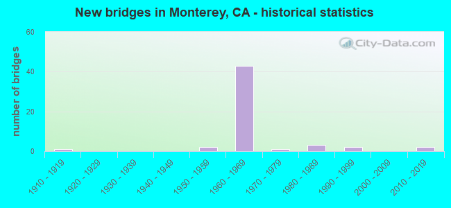
- New bridges - historical statistics
- 11910-1919
- 21950-1959
- 431960-1969
- 11970-1979
- 31980-1989
- 21990-1999
- 22010-2019

- Reconstructed bridges - Historical Statistics
- 11990-1999
- 12000-2009


- Bridge Condition - Deck
- 90.3%Good
- 9.7%Fair

- Bridge Condition - Superstructure
- 90.3%Good
- 9.7%Fair

- Bridge Condition - Substructure
- 96.8%Good
- 3.2%Fair

- Bridge Condition - Channel
- 80.0%Excellent
- 20.0%Good
Find on map >> Show street view
Structure Number: 44 0070E, Location: 05-MON-068-L4.25-MON (Lat: 36.574822, Lng: -121.912536), Route carried "on" structure: Ramp State highway 68, Year Built: 1959, Status: Open, Structure Length: 4.21m (13.81ft), Average Daily Traffic: 27,500 (year 2011), Truck Traffic: 3%, Average Future Daily Traffic: 38,631 (year 2038), Design Load: HS 20, Features Intersected: STATE ROUTE 1
Minimum Vertical Clearance: 30+ m (98+ ft), Kilometerpoint: 4.250, Lanes on structure: 2, Lanes under structure: 4, Base Highway Network: Yes (, Subroute: 1), Owner: State Highway Agency, Approaching Roadway Width: 12.8m (42.0ft), Skew: 2 degrees, Material/Design: Concrete continuous, Design/Construction: Tee Beam, Number Of Spans In Main Unit: 2, Length of Maximum Span: 20.4m (66.9ft), Curb or Sidewalk Widths: Left: 0.5m (1.6ft), Right: 0.5m (1.6ft), Curb-To-Curb Width: 8.5m (27.9ft), Out-to-Out Width: 10.2m (33.5ft)
Condition: Deck: Good, Superstructure: Good, Substructure: Good, Operating Rating: 33.0 metric tons, Method Used To Determine Operating Rating: Load and Resistance Factor Rating (LRFR) rating reported by rating factor(RF) method using HL-93 loadings, Inventory Rating: 25.6 metric tons, Method Used To Determine Inventory Rating: Load and Resistance Factor Rating (LRFR) rating reported by rating factor(RF) method using HL-93 loadings, Structural Evaluation: Equal to present minimum criteria, Deck Geometry: High priority of corrective action, Underclear: High priority of corrective action, Approach Roadway Alignment: Equal to present desirable criteria, Designated Inspection Frequency: Every 24 months, Inspection Date: August 2020, Deck Structure Type: Concrete Cast-file-Place, Wearing Surface/Protective System: Wearing Surface: Bituminous
Find on map >> Show street view
Structure Number: 44 014, Location: 05-MON-101-R2.15 (Lat: 35.815100, Lng: -120.754861), Route carried "on" structure: Other road , Year Built: 1965, Status: Open, Structure Length: 8.32m (27.30ft), Average Daily Traffic: 100 (year 2010), Truck Traffic: 8%, Average Future Daily Traffic: 129 (year 2041), Design Load: HS 20+Mod, Features Intersected: US HIGHWAY 101, Facility Carried by Structure: BRADLEY ROAD
Minimum Vertical Clearance: 30+ m (98+ ft), Kilometerpoint: 0.000, Lanes on structure: 2, Lanes under structure: 5, Owner: State Highway Agency, Approaching Roadway Width: 9.8m (32.2ft), Skew: 3 degrees, Material/Design: Concrete continuous, Design/Construction: Box Beam or Girders - Multiple, Number Of Spans In Main Unit: 4, Length of Maximum Span: 26.8m (87.9ft), Curb or Sidewalk Widths: Left: 1.5m (4.9ft), Right: 0.6m (2.0ft), Curb-To-Curb Width: 9.2m (30.2ft), Out-to-Out Width: 12.2m (40.0ft)
Condition: Deck: Good, Superstructure: Good, Substructure: Good, Operating Rating: 48.6 metric tons, Method Used To Determine Operating Rating: Load and Resistance Factor Rating (LRFR) rating reported by rating factor(RF) method using HL-93 loadings, Inventory Rating: 35.0 metric tons, Method Used To Determine Inventory Rating: Load and Resistance Factor Rating (LRFR) rating reported by rating factor(RF) method using HL-93 loadings, Structural Evaluation: Better than present minimum criteria, Deck Geometry: Better than present minimum criteria, Underclear: High priority of corrective action, Approach Roadway Alignment: Equal to present desirable criteria, Designated Inspection Frequency: Every 48 months, Inspection Date: October 2021, Deck Structure Type: Concrete Cast-file-Place
Find on map >> Show street view
Structure Number: 44 0145L, Location: 05-MON-001-R75.74-MON (Lat: 36.580567, Lng: -121.903658), Route carried "on" structure: State highway 1, Year Built: 1968, Status: Open, Structure Length: 3.84m (12.60ft), Average Daily Traffic: 28,000 (year 2009), Truck Traffic: 3%, Average Future Daily Traffic: 35,107 (year 2043), Design Load: HS 20+Mod, Features Intersected: N1-MUNRAS AVE OFF RAMP
Minimum Vertical Clearance: 30+ m (98+ ft), Kilometerpoint: 75.740, Lanes on structure: 2, Lanes under structure: 1, Base Highway Network: Yes (, Subroute: 1), Owner: State Highway Agency, Approaching Roadway Width: 11.3m (37.1ft), Skew: 5 degrees, Material/Design: Prestressed concrete, Design/Construction: Box Beam or Girders - Multiple, Number Of Spans In Main Unit: 1, Length of Maximum Span: 37.2m (122.0ft), Curb-To-Curb Width: 11.3m (37.1ft), Out-to-Out Width: 11.9m (39.0ft)
Condition: Deck: Good, Superstructure: Good, Substructure: Good, Operating Rating: 52.2 metric tons, Method Used To Determine Operating Rating: Load and Resistance Factor Rating (LRFR) rating reported by rating factor(RF) method using HL-93 loadings, Inventory Rating: 40.2 metric tons, Method Used To Determine Inventory Rating: Load and Resistance Factor Rating (LRFR) rating reported by rating factor(RF) method using HL-93 loadings, Structural Evaluation: Better than present minimum criteria, Deck Geometry: Somewhat better than minimum adequacy, Underclear: Equal to present minimum criteria, Approach Roadway Alignment: Equal to present desirable criteria, Designated Inspection Frequency: Every 24 months, Inspection Date: July 2021, Deck Structure Type: Concrete Cast-file-Place
Find on map >> Show street view
Structure Number: 44 0145R, Location: 05-MON-001-R75.74-MON (Lat: 36.580233, Lng: -121.903786), Route carried "on" structure: State highway 1, Year Built: 1968, Status: Open, Structure Length: 3.84m (12.60ft), Average Daily Traffic: 28,000 (year 2009), Truck Traffic: 3%, Average Future Daily Traffic: 35,107 (year 2043), Design Load: HS 20+Mod, Features Intersected: N1-MUNRAS AVE OFF RAMP
Minimum Vertical Clearance: 30+ m (98+ ft), Kilometerpoint: 75.740, Lanes on structure: 2, Lanes under structure: 1, Base Highway Network: Yes (, Subroute: 1), Owner: State Highway Agency, Approaching Roadway Width: 11.3m (37.1ft), Skew: 5 degrees, Material/Design: Prestressed concrete, Design/Construction: Box Beam or Girders - Multiple, Number Of Spans In Main Unit: 1, Length of Maximum Span: 37.2m (122.0ft), Curb-To-Curb Width: 11.3m (37.1ft), Out-to-Out Width: 11.9m (39.0ft)
Condition: Deck: Good, Superstructure: Good, Substructure: Good, Operating Rating: 52.2 metric tons, Method Used To Determine Operating Rating: Load and Resistance Factor Rating (LRFR) rating reported by rating factor(RF) method using HL-93 loadings, Inventory Rating: 40.2 metric tons, Method Used To Determine Inventory Rating: Load and Resistance Factor Rating (LRFR) rating reported by rating factor(RF) method using HL-93 loadings, Structural Evaluation: Better than present minimum criteria, Deck Geometry: Somewhat better than minimum adequacy, Underclear: Somewhat better than minimum adequacy, Approach Roadway Alignment: Equal to present desirable criteria, Designated Inspection Frequency: Every 24 months, Inspection Date: July 2021, Deck Structure Type: Concrete Cast-file-Place
Find on map >> Show street view
Structure Number: 44 0146L, Location: 05-MON-001-R77.37-MON (Lat: 36.591417, Lng: -121.880603), Route carried "on" structure: State highway 1, Year Built: 1968, Status: Open, Structure Length: 10.37m (34.02ft), Average Daily Traffic: 28,000 (year 2009), Truck Traffic: 3%, Average Future Daily Traffic: 33,733 (year 2037), Design Load: HS 20+Mod, Features Intersected: FREMONT ST-N1 & AGUAJITO
Minimum Vertical Clearance: 30+ m (98+ ft), Kilometerpoint: 77.370, Lanes on structure: 2, Lanes under structure: 7, Base Highway Network: Yes (, Subroute: 1), Owner: State Highway Agency, Approaching Roadway Width: 11.3m (37.1ft), Skew: 9 degrees, Material/Design: Concrete continuous, Design/Construction: Box Beam or Girders - Multiple, Number Of Spans In Main Unit: 4, Length of Maximum Span: 30.3m (99.4ft), Curb-To-Curb Width: 11.3m (37.1ft), Out-to-Out Width: 11.9m (39.0ft)
Condition: Deck: Good, Superstructure: Good, Substructure: Good, Operating Rating: 62.2 metric tons, Method Used To Determine Operating Rating: Load Factor (LF), Inventory Rating: 37.3 metric tons, Method Used To Determine Inventory Rating: Load Factor (LF), Structural Evaluation: Better than present minimum criteria, Deck Geometry: Somewhat better than minimum adequacy, Underclear: Somewhat better than minimum adequacy, Approach Roadway Alignment: Equal to present minimum criteria, Designated Inspection Frequency: Every 48 months, Inspection Date: July 2019, Deck Structure Type: Concrete Cast-file-Place
Find on map >> Show street view
Structure Number: 44 0146R, Location: 05-MON-001-R77.37-MON (Lat: 36.591242, Lng: -121.880444), Route carried "on" structure: State highway 1, Year Built: 1968, Status: Open, Structure Length: 12.27m (40.26ft), Average Daily Traffic: 28,000 (year 2009), Truck Traffic: 3%, Average Future Daily Traffic: 35,107 (year 2043), Design Load: HS 20+Mod, Features Intersected: FREMONT ST-N1 & AGUAJITO
Minimum Vertical Clearance: 30+ m (98+ ft), Kilometerpoint: 77.370, Lanes on structure: 2, Lanes under structure: 12, Base Highway Network: Yes (, Subroute: 1), Owner: State Highway Agency, Approaching Roadway Width: 11.3m (37.1ft), Skew: 9 degrees, Material/Design: Concrete continuous, Design/Construction: Box Beam or Girders - Multiple, Number Of Spans In Main Unit: 4, Length of Maximum Span: 31.3m (102.7ft), Curb-To-Curb Width: 11.3m (37.1ft), Out-to-Out Width: 11.9m (39.0ft)
Condition: Deck: Good, Superstructure: Good, Substructure: Good, Operating Rating: 77.8 metric tons, Method Used To Determine Operating Rating: Load Factor (LF), Inventory Rating: 46.7 metric tons, Method Used To Determine Inventory Rating: Load Factor (LF), Structural Evaluation: Better than present minimum criteria, Deck Geometry: Somewhat better than minimum adequacy, Underclear: High priority of corrective action, Approach Roadway Alignment: Equal to present minimum criteria, Designated Inspection Frequency: Every 24 months, Inspection Date: July 2021, Deck Structure Type: Concrete Cast-file-Place
Find on map >> Show street view
Structure Number: 44 0149E, Location: 05-MON-068-R3.96-MON (Lat: 36.595278, Lng: -121.868831), Route carried "on" structure: Ramp State highway 68, Year Built: 1968, Year Reconstructed: 1996, Status: Open, Structure Length: 7.35m (24.11ft), Average Daily Traffic: 23,256 (year 2008), Truck Traffic: 3%, Average Future Daily Traffic: 29,420 (year 2038), Design Load: HS 20+Mod, Features Intersected: SR 1, S1-E68, N1-FREMONT
Minimum Vertical Clearance: 30+ m (98+ ft), Kilometerpoint: 3.960, Lanes on structure: 2, Lanes under structure: 7, Base Highway Network: Yes (, Subroute: 1), Owner: State Highway Agency, Approaching Roadway Width: 15.2m (49.9ft), Skew: 21 degrees, Material/Design: Prestressed concrete, Design/Construction: Box Beam or Girders - Multiple, Number Of Spans In Main Unit: 1, Number Of Approach Spans: 2, Length of Maximum Span: 31.4m (103.0ft), Curb-To-Curb Width: 15.3m (50.2ft), Out-to-Out Width: 15.9m (52.2ft)
Condition: Deck: Good, Superstructure: Good, Substructure: Good, Operating Rating: 79.4 metric tons, Method Used To Determine Operating Rating: Load Factor (LF), Inventory Rating: 47.6 metric tons, Method Used To Determine Inventory Rating: Load Factor (LF), Structural Evaluation: Better than present minimum criteria, Deck Geometry: Superior to present desirable criteria, Underclear: Meets minimum limits, Approach Roadway Alignment: Equal to present desirable criteria, Designated Inspection Frequency: Every 24 months, Inspection Date: August 2020, Deck Structure Type: Concrete Cast-file-Place
Find on map >> Show street view
Structure Number: 44 0152S, Location: 05-MON-001-R78.18-MON (Lat: 36.595314, Lng: -121.867344), Route carried "on" structure: Ramp State highway 1, Year Built: 1968, Status: Open, Structure Length: 3.66m (12.01ft), Average Daily Traffic: 7,400 (year 2013), Truck Traffic: 8%, Average Future Daily Traffic: 12,385 (year 2043), Design Load: HS 20+Mod, Features Intersected: W68-N1 CONNECTOR RAMP
Minimum Vertical Clearance: 4.52m (14.83ft), Kilometerpoint: 78.180, Lanes on structure: 2, Lanes under structure: 2, Base Highway Network: Yes (, Subroute: 1), Owner: State Highway Agency, Approaching Roadway Width: 10.4m (34.1ft), Skew: 3 degrees, Material/Design: Concrete continuous, Design/Construction: Box Beam or Girders - Multiple, Number Of Spans In Main Unit: 2, Length of Maximum Span: 18.3m (60.0ft), Curb or Sidewalk Widths: Left: 0.6m (2.0ft), Right: 0.0m, Curb-To-Curb Width: 10.4m (34.1ft), Out-to-Out Width: 11.6m (38.1ft)
Condition: Deck: Good, Superstructure: Good, Substructure: Good, Operating Rating: 34.3 metric tons, Method Used To Determine Operating Rating: Load and Resistance Factor Rating (LRFR) rating reported by rating factor(RF) method using HL-93 loadings, Inventory Rating: 26.6 metric tons, Method Used To Determine Inventory Rating: Load and Resistance Factor Rating (LRFR) rating reported by rating factor(RF) method using HL-93 loadings, Structural Evaluation: Equal to present minimum criteria, Deck Geometry: Better than present minimum criteria, Underclear: Meets minimum limits, Approach Roadway Alignment: Equal to present minimum criteria, Designated Inspection Frequency: Every 24 months, Inspection Date: July 2021, Deck Structure Type: Concrete Cast-file-Place
Find on map >> Show street view
Structure Number: 44 0153K, Location: 05-MON-001-R78.18-MON (Lat: 36.595681, Lng: -121.868075), Route carried "on" structure: Ramp State highway 1, Year Built: 1968, Status: Open, Structure Length: 10.98m (36.02ft), Average Daily Traffic: 1,800 (year 2013), Truck Traffic: 8%, Average Future Daily Traffic: 3,013 (year 2043), Design Load: HS 20+Mod, Features Intersected: SR 1 & W68-N1 CONN RMP
Minimum Vertical Clearance: 30+ m (98+ ft), Kilometerpoint: 78.180, Lanes on structure: 1, Lanes under structure: 8, Base Highway Network: Yes, Owner: State Highway Agency, Approaching Roadway Width: 11.0m (36.1ft), Skew: 9 degrees, Material/Design: Prestressed concrete, Design/Construction: Box Beam or Girders - Multiple, Number Of Spans In Main Unit: 1, Number Of Approach Spans: 2, Length of Maximum Span: 40.7m (133.5ft), Curb-To-Curb Width: 11.0m (36.1ft), Out-to-Out Width: 11.6m (38.1ft)
Condition: Deck: Good, Superstructure: Good, Substructure: Good, Operating Rating: 99.8 metric tons, Method Used To Determine Operating Rating: Load Factor (LF), Inventory Rating: 63.2 metric tons, Method Used To Determine Inventory Rating: Load Factor (LF), Structural Evaluation: Better than present minimum criteria, Deck Geometry: Superior to present desirable criteria, Underclear: High priority of corrective action, Approach Roadway Alignment: Equal to present minimum criteria, Designated Inspection Frequency: Every 24 months, Inspection Date: July 2021, Deck Structure Type: Concrete Cast-file-Place, Wearing Surface/Protective System: Wearing Surface: Integral Concrete
Find on map >> Show street view
Structure Number: 44 0156L, Location: 05-MON-001-R78.89-MON (Lat: 36.604286, Lng: -121.861242), Route carried "on" structure: State highway 1, Year Built: 1968, Status: Open, Structure Length: 7.10m (23.29ft), Average Daily Traffic: 29,500 (year 2009), Truck Traffic: 4%, Average Future Daily Traffic: 46,938 (year 2043), Design Load: HS 20+Mod, Features Intersected: DEL MONTE AVE
Minimum Vertical Clearance: 30+ m (98+ ft), Kilometerpoint: 78.890, Lanes on structure: 2, Lanes under structure: 5, Base Highway Network: Yes (, Subroute: 1), Owner: State Highway Agency, Approaching Roadway Width: 11.3m (37.1ft), Skew: 3 degrees, Material/Design: Prestressed concrete continuous, Design/Construction: Box Beam or Girders - Multiple, Number Of Spans In Main Unit: 2, Length of Maximum Span: 36.9m (121.1ft), Curb-To-Curb Width: 11.3m (37.1ft), Out-to-Out Width: 11.9m (39.0ft)
Condition: Deck: Good, Superstructure: Good, Substructure: Good, Operating Rating: 53.1 metric tons, Method Used To Determine Operating Rating: Load and Resistance Factor Rating (LRFR) rating reported by rating factor(RF) method using HL-93 loadings, Inventory Rating: 36.6 metric tons, Method Used To Determine Inventory Rating: Load and Resistance Factor Rating (LRFR) rating reported by rating factor(RF) method using HL-93 loadings, Structural Evaluation: Better than present minimum criteria, Deck Geometry: Somewhat better than minimum adequacy, Underclear: High priority of corrective action, Approach Roadway Alignment: Better than present minimum criteria, Designated Inspection Frequency: Every 24 months, Inspection Date: July 2021, Deck Structure Type: Concrete Cast-file-Place
Find on map >> Show street view
Structure Number: 44 0156R, Location: 05-MON-001-R78.89-MON (Lat: 36.604450, Lng: -121.860950), Route carried "on" structure: State highway 1, Year Built: 1968, Status: Open, Structure Length: 7.10m (23.29ft), Average Daily Traffic: 29,500 (year 2009), Truck Traffic: 4%, Average Future Daily Traffic: 46,938 (year 2043), Design Load: HS 20+Mod, Features Intersected: DEL MONTE AVE
Minimum Vertical Clearance: 30+ m (98+ ft), Kilometerpoint: 78.890, Lanes on structure: 3, Lanes under structure: 5, Base Highway Network: Yes (, Subroute: 1), Owner: State Highway Agency, Approaching Roadway Width: 13.7m (44.9ft), Skew: 3 degrees, Material/Design: Prestressed concrete continuous, Design/Construction: Box Beam or Girders - Multiple, Number Of Spans In Main Unit: 2, Length of Maximum Span: 36.9m (121.1ft), Curb or Sidewalk Widths: Left: 0.0m, Right: 0.6m (2.0ft), Curb-To-Curb Width: 12.8m (42.0ft), Out-to-Out Width: 14.0m (45.9ft)
Condition: Deck: Good, Superstructure: Good, Substructure: Good, Operating Rating: 45.4 metric tons, Method Used To Determine Operating Rating: Load and Resistance Factor Rating (LRFR) rating reported by rating factor(RF) method using HL-93 loadings, Inventory Rating: 28.8 metric tons, Method Used To Determine Inventory Rating: Load and Resistance Factor Rating (LRFR) rating reported by rating factor(RF) method using HL-93 loadings, Structural Evaluation: Better than present minimum criteria, Deck Geometry: Meets minimum limits, Underclear: High priority of corrective action, Approach Roadway Alignment: Better than present minimum criteria, Designated Inspection Frequency: Every 24 months, Inspection Date: July 2021, Deck Structure Type: Concrete Cast-file-Place
Find on map >> Show street view
Structure Number: 44 0157K, Location: 05-MON-001-R78.85-MON (Lat: 36.603875, Lng: -121.862744), Route carried "on" structure: Ramp State highway 1, Year Built: 1968, Status: Open, Structure Length: 14.95m (49.05ft), Average Daily Traffic: 8,900 (year 2013), Truck Traffic: 8%, Average Future Daily Traffic: 14,899 (year 2043), Features Intersected: PEDESTRIAN WALKWAY
Minimum Vertical Clearance: 30+ m (98+ ft), Kilometerpoint: 78.850, Lanes on structure: 1, Base Highway Network: Yes (, Subroute: 1), Owner: State Highway Agency, Approaching Roadway Width: 7.3m (24.0ft), Material/Design: Prestressed concrete continuous, Design/Construction: Box Beam or Girders - Multiple, Number Of Spans In Main Unit: 2, Number Of Approach Spans: 3, Length of Maximum Span: 38.1m (125.0ft), Curb-To-Curb Width: 7.3m (24.0ft), Out-to-Out Width: 7.9m (25.9ft)
Condition: Deck: Good, Superstructure: Good, Substructure: Good, Operating Rating: 54.0 metric tons, Method Used To Determine Operating Rating: Field evaluation and documented engineering judgment, Inventory Rating: 32.4 metric tons, Method Used To Determine Inventory Rating: Field evaluation and documented engineering judgment, Structural Evaluation: Better than present minimum criteria, Deck Geometry: Better than present minimum criteria, Approach Roadway Alignment: Equal to present minimum criteria, Designated Inspection Frequency: Every 24 months, Inspection Date: July 2021, Deck Structure Type: Concrete Cast-file-Place
Find on map >> Show street view
Structure Number: 44 0162L, Location: 05-MON-001-R79.33-SEA (Lat: 36.610128, Lng: -121.858122), Route carried "on" structure: State highway 1, Year Built: 1968, Status: Open, Structure Length: 5.30m (17.39ft), Average Daily Traffic: 29,500 (year 2009), Truck Traffic: 4%, Average Future Daily Traffic: 47,567 (year 2043), Design Load: HS 20, Features Intersected: STATE ROUTE 218
Minimum Vertical Clearance: 30+ m (98+ ft), Kilometerpoint: 79.330, Lanes on structure: 2, Lanes under structure: 2, Base Highway Network: Yes (, Subroute: 1), Owner: State Highway Agency, Approaching Roadway Width: 11.3m (37.1ft), Skew: 3 degrees, Material/Design: Concrete continuous, Design/Construction: Box Beam or Girders - Multiple, Number Of Spans In Main Unit: 3, Length of Maximum Span: 25.0m (82.0ft), Curb-To-Curb Width: 11.3m (37.1ft), Out-to-Out Width: 11.9m (39.0ft)
Condition: Deck: Good, Superstructure: Good, Substructure: Good, Operating Rating: 48.9 metric tons, Method Used To Determine Operating Rating: Load and Resistance Factor Rating (LRFR) rating reported by rating factor(RF) method using HL-93 loadings, Inventory Rating: 37.9 metric tons, Method Used To Determine Inventory Rating: Load and Resistance Factor Rating (LRFR) rating reported by rating factor(RF) method using HL-93 loadings, Structural Evaluation: Better than present minimum criteria, Deck Geometry: Somewhat better than minimum adequacy, Underclear: Equal to present minimum criteria, Approach Roadway Alignment: Equal to present minimum criteria, Designated Inspection Frequency: Every 48 months, Inspection Date: July 2021, Deck Structure Type: Concrete Cast-file-Place
Find on map >> Show street view
Structure Number: 44 0168L, Location: 05-MON-001-R77.59-MON (Lat: 36.593269, Lng: -121.877422), Route carried "on" structure: State highway 1, Year Built: 1968, Status: Open, Structure Length: 2.86m (9.38ft), Average Daily Traffic: 41,000 (year 2009), Truck Traffic: 3%, Average Future Daily Traffic: 35,671 (year 2043), Design Load: HS 20+Mod, Features Intersected: SLOAT AVENUE
Minimum Vertical Clearance: 30+ m (98+ ft), Kilometerpoint: 77.590, Lanes on structure: 4, Lanes under structure: 4, Base Highway Network: Yes (, Subroute: 1), Owner: State Highway Agency, Approaching Roadway Width: 18.3m (60.0ft), Material/Design: Prestressed concrete, Design/Construction: Box Beam or Girders - Multiple, Number Of Spans In Main Unit: 1, Length of Maximum Span: 28.6m (93.8ft), Curb-To-Curb Width: 18.3m (60.0ft), Out-to-Out Width: 19.0m (62.3ft)
Condition: Deck: Good, Superstructure: Good, Substructure: Good, Operating Rating: 48.3 metric tons, Method Used To Determine Operating Rating: Load and Resistance Factor Rating (LRFR) rating reported by rating factor(RF) method using HL-93 loadings, Inventory Rating: 25.6 metric tons, Method Used To Determine Inventory Rating: Load and Resistance Factor Rating (LRFR) rating reported by rating factor(RF) method using HL-93 loadings, Structural Evaluation: Equal to present minimum criteria, Deck Geometry: Meets minimum limits, Underclear: Meets minimum limits, Approach Roadway Alignment: Equal to present minimum criteria, Designated Inspection Frequency: Every 24 months, Inspection Date: July 2021, Deck Structure Type: Concrete Cast-file-Place
Find on map >> Show street view
Structure Number: 44 0168R, Location: 05-MON-001-R77.59-MON (Lat: 36.593008, Lng: -121.877353), Route carried "on" structure: State highway 1, Year Built: 1968, Status: Open, Structure Length: 2.87m (9.42ft), Average Daily Traffic: 41,000 (year 2009), Truck Traffic: 3%, Average Future Daily Traffic: 35,671 (year 2043), Design Load: HS 20+Mod, Features Intersected: SLOAT AVENUE
Minimum Vertical Clearance: 30+ m (98+ ft), Kilometerpoint: 77.590, Lanes on structure: 4, Lanes under structure: 4, Base Highway Network: Yes (, Subroute: 1), Owner: State Highway Agency, Approaching Roadway Width: 20.7m (67.9ft), Material/Design: Prestressed concrete, Design/Construction: Box Beam or Girders - Multiple, Number Of Spans In Main Unit: 1, Length of Maximum Span: 28.7m (94.2ft), Curb-To-Curb Width: 20.7m (67.9ft), Out-to-Out Width: 21.3m (69.9ft)
Condition: Deck: Good, Superstructure: Good, Substructure: Good, Operating Rating: 49.6 metric tons, Method Used To Determine Operating Rating: Load and Resistance Factor Rating (LRFR) rating reported by rating factor(RF) method using HL-93 loadings, Inventory Rating: 26.6 metric tons, Method Used To Determine Inventory Rating: Load and Resistance Factor Rating (LRFR) rating reported by rating factor(RF) method using HL-93 loadings, Structural Evaluation: Equal to present minimum criteria, Deck Geometry: Equal to present minimum criteria, Underclear: Meets minimum limits, Approach Roadway Alignment: Equal to present desirable criteria, Designated Inspection Frequency: Every 24 months, Inspection Date: July 2021, Deck Structure Type: Concrete Cast-file-Place
Find on map >> Show street view
Structure Number: 44 0180L, Location: 05-MON-101-R40.72-KNC (Lat: 36.203217, Lng: -121.129306), Route carried "on" structure: US 101, Year Built: 1968, Status: Open, Structure Length: 3.72m (12.20ft), Average Daily Traffic: 7,950 (year 2009), Average Future Daily Traffic: 13,429 (year 2043), Design Load: HS 20+Mod, Features Intersected: CANAL STREET
Minimum Vertical Clearance: 30+ m (98+ ft), Kilometerpoint: 40.720, Lanes on structure: 2, Lanes under structure: 2, Base Highway Network: Yes (Inventory Route: 1, Subroute: 1), Owner: State Highway Agency, Approaching Roadway Width: 11.3m (37.1ft), Skew: 3 degrees, Material/Design: Concrete continuous, Design/Construction: Box Beam or Girders - Multiple, Number Of Spans In Main Unit: 3, Length of Maximum Span: 20.0m (65.6ft), Curb-To-Curb Width: 11.3m (37.1ft), Out-to-Out Width: 11.9m (39.0ft)
Condition: Deck: Good, Superstructure: Fair, Substructure: Good, Operating Rating: 39.5 metric tons, Method Used To Determine Operating Rating: Load and Resistance Factor Rating (LRFR) rating reported by rating factor(RF) method using HL-93 loadings, Inventory Rating: 30.5 metric tons, Method Used To Determine Inventory Rating: Load and Resistance Factor Rating (LRFR) rating reported by rating factor(RF) method using HL-93 loadings, Structural Evaluation: Somewhat better than minimum adequacy, Deck Geometry: Somewhat better than minimum adequacy, Underclear: Meets minimum limits, Approach Roadway Alignment: Equal to present desirable criteria, Designated Inspection Frequency: Every 24 months, Inspection Date: October 2021, Deck Structure Type: Concrete Cast-file-Place
Find on map >> Show street view
Structure Number: 44 0187L, Location: 05-MON-001-R78.45-MON (Lat: 36.598889, Lng: -121.864650), Route carried "on" structure: State highway 1, Year Built: 1968, Status: Open, Structure Length: 2.87m (9.42ft), Average Daily Traffic: 29,500 (year 2009), Truck Traffic: 4%, Average Future Daily Traffic: 47,874 (year 2043), Design Load: HS 20+Mod, Features Intersected: CASA VERDE AVE
Minimum Vertical Clearance: 30+ m (98+ ft), Kilometerpoint: 78.450, Lanes on structure: 2, Lanes under structure: 2, Base Highway Network: Yes (, Subroute: 1), Owner: State Highway Agency, Approaching Roadway Width: 11.3m (37.1ft), Skew: 1 degrees, Material/Design: Prestressed concrete, Design/Construction: Box Beam or Girders - Multiple, Number Of Spans In Main Unit: 1, Length of Maximum Span: 28.0m (91.9ft), Curb-To-Curb Width: 11.2m (36.7ft), Out-to-Out Width: 11.8m (38.7ft)
Condition: Deck: Good, Superstructure: Good, Substructure: Good, Operating Rating: 44.7 metric tons, Method Used To Determine Operating Rating: Load and Resistance Factor Rating (LRFR) rating reported by rating factor(RF) method using HL-93 loadings, Inventory Rating: 26.2 metric tons, Method Used To Determine Inventory Rating: Load and Resistance Factor Rating (LRFR) rating reported by rating factor(RF) method using HL-93 loadings, Structural Evaluation: Equal to present minimum criteria, Deck Geometry: Somewhat better than minimum adequacy, Underclear: Equal to present minimum criteria, Approach Roadway Alignment: Equal to present desirable criteria, Designated Inspection Frequency: Every 24 months, Inspection Date: July 2021, Deck Structure Type: Concrete Cast-file-Place
Find on map >> Show street view
Structure Number: 44 0187R, Location: 05-MON-001-R78.45-MON (Lat: 36.598747, Lng: -121.864472), Route carried "on" structure: State highway 1, Year Built: 1968, Status: Open, Structure Length: 2.87m (9.42ft), Average Daily Traffic: 29,500 (year 2009), Truck Traffic: 4%, Average Future Daily Traffic: 47,874 (year 2043), Design Load: HS 20+Mod, Features Intersected: CASA VERDE AVE
Minimum Vertical Clearance: 30+ m (98+ ft), Kilometerpoint: 78.450, Lanes on structure: 2, Lanes under structure: 2, Base Highway Network: Yes (, Subroute: 1), Owner: State Highway Agency, Approaching Roadway Width: 11.3m (37.1ft), Skew: 1 degrees, Material/Design: Prestressed concrete, Design/Construction: Box Beam or Girders - Multiple, Number Of Spans In Main Unit: 1, Length of Maximum Span: 28.0m (91.9ft), Curb-To-Curb Width: 11.3m (37.1ft), Out-to-Out Width: 11.9m (39.0ft)
Condition: Deck: Good, Superstructure: Good, Substructure: Good, Operating Rating: 44.7 metric tons, Method Used To Determine Operating Rating: Load and Resistance Factor Rating (LRFR) rating reported by rating factor(RF) method using HL-93 loadings, Inventory Rating: 26.2 metric tons, Method Used To Determine Inventory Rating: Load and Resistance Factor Rating (LRFR) rating reported by rating factor(RF) method using HL-93 loadings, Structural Evaluation: Equal to present minimum criteria, Deck Geometry: Somewhat better than minimum adequacy, Underclear: Equal to present minimum criteria, Approach Roadway Alignment: Equal to present desirable criteria, Designated Inspection Frequency: Every 24 months, Inspection Date: July 2021, Deck Structure Type: Concrete Cast-file-Place
Find on map >> Show street view
Structure Number: 44 0190L, Location: 05-MON-101-R37.31 (Lat: 36.187417, Lng: -121.072289), Route carried "on" structure: US 101, Year Built: 1969, Status: Open, Structure Length: 2.98m (9.78ft), Average Daily Traffic: 7,950 (year 2009), Truck Traffic: 19%, Average Future Daily Traffic: 13,914 (year 2043), Design Load: HS 20+Mod, Features Intersected: WILD HORSE ROAD
Minimum Vertical Clearance: 30+ m (98+ ft), Kilometerpoint: 37.310, Lanes on structure: 2, Lanes under structure: 2, Base Highway Network: Yes (Inventory Route: 1, Subroute: 1), Owner: State Highway Agency, Approaching Roadway Width: 11.9m (39.0ft), Material/Design: Prestressed concrete, Design/Construction: Box Beam or Girders - Multiple, Number Of Spans In Main Unit: 1, Length of Maximum Span: 29.3m (96.1ft), Curb-To-Curb Width: 11.9m (39.0ft), Out-to-Out Width: 12.5m (41.0ft)
Condition: Deck: Good, Superstructure: Good, Substructure: Good, Operating Rating: 42.8 metric tons, Method Used To Determine Operating Rating: Load and Resistance Factor Rating (LRFR) rating reported by rating factor(RF) method using HL-93 loadings, Inventory Rating: 30.5 metric tons, Method Used To Determine Inventory Rating: Load and Resistance Factor Rating (LRFR) rating reported by rating factor(RF) method using HL-93 loadings, Structural Evaluation: Better than present minimum criteria, Deck Geometry: Better than present minimum criteria, Underclear: Meets minimum limits, Approach Roadway Alignment: Equal to present desirable criteria, Designated Inspection Frequency: Every 24 months, Inspection Date: October 2021, Deck Structure Type: Concrete Cast-file-Place
Find on map >> Show street view
Structure Number: 44 0191L, Location: 05-MON-001-R76.00-MON (Lat: 36.582011, Lng: -121.899872), Route carried "on" structure: State highway 1, Year Built: 1968, Status: Open, Structure Length: 5.03m (16.50ft), Average Daily Traffic: 28,000 (year 2009), Truck Traffic: 3%, Average Future Daily Traffic: 35,578 (year 2043), Design Load: HS 20, Features Intersected: SOLEDAD DRIVE
Minimum Vertical Clearance: 30+ m (98+ ft), Kilometerpoint: 76.000, Lanes on structure: 3, Lanes under structure: 4, Base Highway Network: Yes (, Subroute: 1), Owner: State Highway Agency, Approaching Roadway Width: 17.1m (56.1ft), Skew: 3 degrees, Material/Design: Prestressed concrete continuous, Design/Construction: Box Beam or Girders - Multiple, Number Of Spans In Main Unit: 2, Length of Maximum Span: 27.4m (89.9ft), Curb-To-Curb Width: 13.5m (44.3ft), Out-to-Out Width: 17.8m (58.4ft)
Condition: Deck: Good, Superstructure: Good, Substructure: Good, Operating Rating: 86.8 metric tons, Method Used To Determine Operating Rating: Load Factor (LF), Inventory Rating: 32.4 metric tons, Method Used To Determine Inventory Rating: Load Factor (LF), Structural Evaluation: Better than present minimum criteria, Deck Geometry: High priority of replacement, Underclear: Superior to present desirable criteria, Approach Roadway Alignment: Equal to present desirable criteria, Designated Inspection Frequency: Every 48 months, Inspection Date: July 2021, Deck Structure Type: Concrete Cast-file-Place
Find on map >> Show street view
Structure Number: 44 0191R, Location: 05-MON-001-R76.00-MON (Lat: 36.581833, Lng: -121.899700), Route carried "on" structure: State highway 1, Year Built: 1968, Status: Open, Structure Length: 4.48m (14.70ft), Average Daily Traffic: 28,000 (year 2009), Truck Traffic: 3%, Average Future Daily Traffic: 35,695 (year 2043), Design Load: HS 20+Mod, Features Intersected: SOLEDAD DRIVE
Minimum Vertical Clearance: 30+ m (98+ ft), Kilometerpoint: 76.000, Lanes on structure: 2, Lanes under structure: 4, Base Highway Network: Yes (, Subroute: 1), Owner: State Highway Agency, Approaching Roadway Width: 11.3m (37.1ft), Skew: 2 degrees, Material/Design: Prestressed concrete continuous, Design/Construction: Box Beam or Girders - Multiple, Number Of Spans In Main Unit: 2, Length of Maximum Span: 24.4m (80.1ft), Curb-To-Curb Width: 11.3m (37.1ft), Out-to-Out Width: 11.9m (39.0ft)
Condition: Deck: Good, Superstructure: Good, Substructure: Good, Operating Rating: 37.6 metric tons, Method Used To Determine Operating Rating: Load and Resistance Factor Rating (LRFR) rating reported by rating factor(RF) method using HL-93 loadings, Inventory Rating: 29.2 metric tons, Method Used To Determine Inventory Rating: Load and Resistance Factor Rating (LRFR) rating reported by rating factor(RF) method using HL-93 loadings, Structural Evaluation: Better than present minimum criteria, Deck Geometry: Somewhat better than minimum adequacy, Underclear: Equal to present minimum criteria, Approach Roadway Alignment: Equal to present desirable criteria, Designated Inspection Frequency: Every 24 months, Inspection Date: July 2021, Deck Structure Type: Concrete Cast-file-Place
Find on map >> Show street view
Structure Number: 44 0192L, Location: 05-MON-001-R76.47-MON (Lat: 36.583253, Lng: -121.891433), Route carried "on" structure: State highway 1, Year Built: 1968, Status: Open, Structure Length: 3.78m (12.40ft), Average Daily Traffic: 28,000 (year 2009), Truck Traffic: 3%, Average Future Daily Traffic: 35,107 (year 2043), Design Load: HS 20+Mod, Features Intersected: IRIS CANYON ROAD
Minimum Vertical Clearance: 30+ m (98+ ft), Kilometerpoint: 76.470, Lanes on structure: 2, Lanes under structure: 2, Base Highway Network: Yes (, Subroute: 1), Owner: State Highway Agency, Approaching Roadway Width: 11.3m (37.1ft), Material/Design: Concrete continuous, Design/Construction: Box Beam or Girders - Multiple, Number Of Spans In Main Unit: 2, Length of Maximum Span: 18.9m (62.0ft), Curb-To-Curb Width: 11.3m (37.1ft), Out-to-Out Width: 11.9m (39.0ft)
Condition: Deck: Good, Superstructure: Good, Substructure: Good, Operating Rating: 35.6 metric tons, Method Used To Determine Operating Rating: Load and Resistance Factor Rating (LRFR) rating reported by rating factor(RF) method using HL-93 loadings, Inventory Rating: 27.5 metric tons, Method Used To Determine Inventory Rating: Load and Resistance Factor Rating (LRFR) rating reported by rating factor(RF) method using HL-93 loadings, Structural Evaluation: Equal to present minimum criteria, Deck Geometry: Somewhat better than minimum adequacy, Underclear: Meets minimum limits, Approach Roadway Alignment: Equal to present desirable criteria, Designated Inspection Frequency: Every 24 months, Inspection Date: July 2021, Deck Structure Type: Concrete Cast-file-Place
Find on map >> Show street view
Structure Number: 44 0192R, Location: 05-MON-001-R76.47-MON (Lat: 36.583056, Lng: -121.891428), Route carried "on" structure: State highway 1, Year Built: 1968, Status: Open, Structure Length: 3.78m (12.40ft), Average Daily Traffic: 28,000 (year 2009), Truck Traffic: 3%, Average Future Daily Traffic: 35,107 (year 2043), Design Load: HS 20+Mod, Features Intersected: IRIS CANYON ROAD
Minimum Vertical Clearance: 30+ m (98+ ft), Kilometerpoint: 76.470, Lanes on structure: 2, Lanes under structure: 2, Base Highway Network: Yes (, Subroute: 1), Owner: State Highway Agency, Approaching Roadway Width: 11.3m (37.1ft), Material/Design: Concrete continuous, Design/Construction: Box Beam or Girders - Multiple, Number Of Spans In Main Unit: 2, Length of Maximum Span: 18.9m (62.0ft), Curb-To-Curb Width: 11.3m (37.1ft), Out-to-Out Width: 11.9m (39.0ft)
Condition: Deck: Good, Superstructure: Good, Substructure: Good, Operating Rating: 35.6 metric tons, Method Used To Determine Operating Rating: Load and Resistance Factor Rating (LRFR) rating reported by rating factor(RF) method using HL-93 loadings, Inventory Rating: 27.5 metric tons, Method Used To Determine Inventory Rating: Load and Resistance Factor Rating (LRFR) rating reported by rating factor(RF) method using HL-93 loadings, Structural Evaluation: Equal to present minimum criteria, Deck Geometry: Somewhat better than minimum adequacy, Underclear: Meets minimum limits, Approach Roadway Alignment: Equal to present desirable criteria, Designated Inspection Frequency: Every 24 months, Inspection Date: July 2021, Deck Structure Type: Concrete Cast-file-Place
Find on map >> Show street view
Structure Number: 44 029, Location: 05-MON-001-21.50 (Lat: 36.011142, Lng: -121.524764), Route carried "on" structure: State highway 1, Year Built: 2013, Status: Open, Structure Length: 18.90m (62.01ft), Average Daily Traffic: 2,000 (year 2009), Average Future Daily Traffic: 2,729 (year 2038), Design Load: HL 93, Features Intersected: HILLSIDE
Minimum Vertical Clearance: 30+ m (98+ ft), Kilometerpoint: 21.500, Lanes on structure: 2, Base Highway Network: Yes (, Subroute: 1), Owner: State Highway Agency, Approaching Roadway Width: 9.8m (32.2ft), Material/Design: Prestressed concrete continuous, Design/Construction: Segmental Box Girder, Number Of Spans In Main Unit: 1, Number Of Approach Spans: 2, Length of Maximum Span: 94.8m (311.0ft), Curb-To-Curb Width: 9.8m (32.2ft), Out-to-Out Width: 10.8m (35.4ft)
Condition: Deck: Good, Superstructure: Good, Substructure: Good, Operating Rating: 42.1 metric tons, Method Used To Determine Operating Rating: Assigned ratings based on Load and Resistance Factor Design (LRFD) reported by rating factor (RF) using HL93 loadings, Inventory Rating: 32.4 metric tons, Method Used To Determine Inventory Rating: Assigned ratings based on Load and Resistance Factor Design (LRFD) reported by rating factor (RF) using HL93 loadings, Structural Evaluation: Better than present minimum criteria, Deck Geometry: Somewhat better than minimum adequacy, Approach Roadway Alignment: Equal to present desirable criteria, Designated Inspection Frequency: Every 24 months, Inspection Date: Febuary 2021, Deck Structure Type: Concrete Cast-file-Place
Find on map >> Show street view
Structure Number: 44C008, Location: 0.4 MI E SAN JUAN GRADE R (Lat: 36.755769, Lng: -121.610239), Route carried "on" structure: County highway , Year Built: 1975, Status: Open, Structure Length: 2.00m (6.56ft), Average Daily Traffic: 5,900 (year 2016), Truck Traffic: 5%, Average Future Daily Traffic: 8,541 (year 2038), Design Load: HS 20, Features Intersected: GABILAN CREEK, Facility Carried by Structure: HEBERT RD
Minimum Vertical Clearance: 30+ m (98+ ft), Kilometerpoint: 0.000, Lanes on structure: 2, Owner: County Highway Agency, Approaching Roadway Width: 7.6m (24.9ft), Material/Design: Concrete continuous, Design/Construction: Slab, Number Of Spans In Main Unit: 3, Length of Maximum Span: 7.8m (25.6ft), Curb-To-Curb Width: 12.2m (40.0ft), Out-to-Out Width: 12.4m (40.7ft)
Condition: Deck: Fair, Superstructure: Fair, Substructure: Good, Channel: Excellent, Operating Rating: 71.0 metric tons, Method Used To Determine Operating Rating: Load Factor (LF), Inventory Rating: 42.8 metric tons, Method Used To Determine Inventory Rating: Load Factor (LF), Structural Evaluation: Somewhat better than minimum adequacy, Deck Geometry: Somewhat better than minimum adequacy, Waterway Adequacy: Better than present minimum criteria, Approach Roadway Alignment: Equal to present desirable criteria, Designated Inspection Frequency: Every 24 months, Inspection Date: August 2021, Deck Structure Type: Concrete Cast-file-Place
Find on map >> Show street view
Structure Number: 44C0082, Location: 0.05 MI S MADISON ST (Lat: 36.596278, Lng: -121.900283), Route carried "on" structure: City street , Year Built: 1914, Year Reconstructed: 2007, Status: Open, Structure Length: 3.29m (10.79ft), Average Daily Traffic: 3,000 (year 2008), Truck Traffic: 3%, Average Future Daily Traffic: 6,000 (year 2037), Features Intersected: HARTNELL GULCH, Facility Carried by Structure: LARKIN ST
Minimum Vertical Clearance: 30+ m (98+ ft), Kilometerpoint: 0.000, Lanes on structure: 2, Owner: City or Municipal Highway Agency, Approaching Roadway Width: 10.9m (35.8ft), Material/Design: Concrete, Design/Construction: Arch - Deck, Number Of Spans In Main Unit: 1, Number Of Approach Spans: 2, Length of Maximum Span: 18.7m (61.4ft), Curb or Sidewalk Widths: Left: 1.4m (4.6ft), Right: 1.4m (4.6ft), Curb-To-Curb Width: 6.4m (21.0ft), Out-to-Out Width: 10.8m (35.4ft)
Condition: Deck: Good, Superstructure: Fair, Substructure: Fair, Channel: Excellent, Operating Rating: 24.6 metric tons, Method Used To Determine Operating Rating: Field evaluation and documented engineering judgment, Inventory Rating: 14.9 metric tons, Method Used To Determine Inventory Rating: Field evaluation and documented engineering judgment, Structural Evaluation: Meets minimum limits, Deck Geometry: High priority of replacement, Waterway Adequacy: Equal to present minimum criteria, Approach Roadway Alignment: Better than present minimum criteria, Designated Inspection Frequency: Every 24 months, Inspection Date: June 2020, Deck Structure Type: Concrete Cast-file-Place, Wearing Surface/Protective System: Wearing Surface: Bituminous
Find on map >> Show street view
Structure Number: 44C0083, Location: NEAR SH 68 (Lat: 36.585817, Lng: -121.918244), Route carried "on" structure: City street , Year Built: 1965, Status: Open, Structure Length: 2.74m (8.99ft), Average Daily Traffic: 4,300 (year 2008), Truck Traffic: 1%, Average Future Daily Traffic: 3,184 (year 2037), Design Load: HS 20, Features Intersected: SCENIC DRIVE, Facility Carried by Structure: SKYLINE FOREST DR
Minimum Vertical Clearance: 30+ m (98+ ft), Kilometerpoint: 0.000, Lanes on structure: 2, Lanes under structure: 2, Owner: City or Municipal Highway Agency, Approaching Roadway Width: 7.3m (24.0ft), Material/Design: Concrete continuous, Design/Construction: Tee Beam, Number Of Spans In Main Unit: 3, Length of Maximum Span: 10.7m (35.1ft), Curb-To-Curb Width: 8.6m (28.2ft), Out-to-Out Width: 9.1m (29.9ft)
Condition: Deck: Fair, Superstructure: Good, Substructure: Good, Operating Rating: 39.2 metric tons, Method Used To Determine Operating Rating: Load and Resistance Factor Rating (LRFR) rating reported by rating factor(RF) method using HL-93 loadings, Inventory Rating: 30.1 metric tons, Method Used To Determine Inventory Rating: Load and Resistance Factor Rating (LRFR) rating reported by rating factor(RF) method using HL-93 loadings, Structural Evaluation: Better than present minimum criteria, Deck Geometry: Meets minimum limits, Underclear: Meets minimum limits, Approach Roadway Alignment: Equal to present desirable criteria, Designated Inspection Frequency: Every 24 months, Inspection Date: June 2020, Deck Structure Type: Concrete Cast-file-Place
Find on map >> Show street view
Structure Number: 44C0084, Location: AT CAMINO EL ESTERO (Lat: 36.597544, Lng: -121.887867), Route carried "on" structure: City street , Year Built: 1991, Status: Open, Structure Length: 3.51m (11.52ft), Average Daily Traffic: 1,500 (year 2008), Truck Traffic: 1%, Average Future Daily Traffic: 1,670 (year 2037), Design Load: HS 20+Mod, Features Intersected: EL ESTERO LAKE WEST, Facility Carried by Structure: PEARL ST
Minimum Vertical Clearance: 30+ m (98+ ft), Kilometerpoint: 0.000, Lanes on structure: 2, Owner: City or Municipal Highway Agency, Approaching Roadway Width: 9.8m (32.2ft), Material/Design: Concrete continuous, Design/Construction: Slab, Number Of Spans In Main Unit: 4, Length of Maximum Span: 8.8m (28.9ft), Curb or Sidewalk Widths: Left: 1.5m (4.9ft), Right: 1.5m (4.9ft), Curb-To-Curb Width: 9.8m (32.2ft), Out-to-Out Width: 13.7m (44.9ft)
Condition: Deck: Good, Superstructure: Good, Substructure: Good, Channel: Excellent, Operating Rating: 33.4 metric tons, Method Used To Determine Operating Rating: Load and Resistance Factor Rating (LRFR) rating reported by rating factor(RF) method using HL-93 loadings, Inventory Rating: 25.9 metric tons, Method Used To Determine Inventory Rating: Load and Resistance Factor Rating (LRFR) rating reported by rating factor(RF) method using HL-93 loadings, Structural Evaluation: Equal to present minimum criteria, Deck Geometry: Somewhat better than minimum adequacy, Waterway Adequacy: Equal to present desirable criteria, Approach Roadway Alignment: Equal to present desirable criteria, Designated Inspection Frequency: Every 24 months, Inspection Date: June 2020, Deck Structure Type: Concrete Cast-file-Place
Find on map >> Show street view
Structure Number: 44C0085, Location: AT CAMINO AGUAJITO (Lat: 36.597244, Lng: -121.883600), Route carried "on" structure: City street , Year Built: 1991, Status: Open, Structure Length: 5.82m (19.09ft), Average Daily Traffic: 1,500 (year 2008), Truck Traffic: 1%, Average Future Daily Traffic: 1,670 (year 2037), Design Load: HS 20+Mod, Features Intersected: EL ESTERO LAKE EAST, Facility Carried by Structure: PEARL ST
Minimum Vertical Clearance: 30+ m (98+ ft), Kilometerpoint: 0.000, Lanes on structure: 2, Owner: City or Municipal Highway Agency, Approaching Roadway Width: 9.8m (32.2ft), Material/Design: Concrete continuous, Design/Construction: Slab, Number Of Spans In Main Unit: 6, Length of Maximum Span: 9.7m (31.8ft), Curb or Sidewalk Widths: Left: 1.5m (4.9ft), Right: 1.5m (4.9ft), Curb-To-Curb Width: 9.8m (32.2ft), Out-to-Out Width: 13.7m (44.9ft)
Condition: Deck: Good, Superstructure: Good, Substructure: Good, Channel: Excellent, Operating Rating: 54.1 metric tons, Method Used To Determine Operating Rating: Assigned rating based on Load Factor Design (LFD) reported in metric tons, Inventory Rating: 32.4 metric tons, Method Used To Determine Inventory Rating: Assigned rating based on Load Factor Design (LFD) reported in metric tons, Structural Evaluation: Better than present minimum criteria, Deck Geometry: Somewhat better than minimum adequacy, Waterway Adequacy: Equal to present desirable criteria, Approach Roadway Alignment: Equal to present desirable criteria, Designated Inspection Frequency: Every 48 months, Inspection Date: June 2020, Deck Structure Type: Concrete Cast-file-Place
Find on map >> Show street view
Structure Number: 44C0116, Location: 0.6 MI S CARMEL VALLEY RD (Lat: 36.530278, Lng: -121.858106), Route carried "on" structure: County highway , Year Built: 1963, Status: Open, Structure Length: 5.67m (18.60ft), Average Daily Traffic: 1,400 (year 2017), Truck Traffic: 2%, Average Future Daily Traffic: 2,600 (year 2037), Features Intersected: CARMEL RIVER, Facility Carried by Structure: VALLEY GREEN DR
Minimum Vertical Clearance: 30+ m (98+ ft), Kilometerpoint: 0.000, Lanes on structure: 2, Owner: County Highway Agency, Approaching Roadway Width: 8.5m (27.9ft), Material/Design: Concrete continuous, Design/Construction: Tee Beam, Number Of Spans In Main Unit: 3, Length of Maximum Span: 21.4m (70.2ft), Curb or Sidewalk Widths: Left: 2.7m (8.9ft), Right: 0.6m (2.0ft), Curb-To-Curb Width: 8.5m (27.9ft), Out-to-Out Width: 12.2m (40.0ft)
Condition: Deck: Fair, Superstructure: Good, Substructure: Good, Channel: Good, Operating Rating: 29.2 metric tons, Method Used To Determine Operating Rating: Field evaluation and documented engineering judgment, Inventory Rating: 17.5 metric tons, Method Used To Determine Inventory Rating: Field evaluation and documented engineering judgment, Structural Evaluation: Meets minimum limits, Deck Geometry: Somewhat better than minimum adequacy, Waterway Adequacy: Better than present minimum criteria, Approach Roadway Alignment: Somewhat better than minimum adequacy, Designated Inspection Frequency: Every 24 months, Inspection Date: June 2020, Deck Structure Type: Concrete Cast-file-Place, Wearing Surface/Protective System: Wearing Surface: Integral Concrete
Find on map >> Show street view
Structure Number: 44C017, Location: AT ROBINSON CANYON ROAD (Lat: 36.522092, Lng: -121.805808), Route carried "on" structure: County highway , Year Built: 1985, Status: Open, Structure Length: 0.98m (3.22ft), Average Daily Traffic: 3,600 (year 2017), Truck Traffic: 5%, Average Future Daily Traffic: 6,800 (year 2037), Features Intersected: ROBINSON CANYON ROAD, Facility Carried by Structure: CARMEL VALLEY RD
Minimum Vertical Clearance: 30+ m (98+ ft), Kilometerpoint: 0.000, Lanes on structure: 4, Lanes under structure: 1, Owner: County Highway Agency, Approaching Roadway Width: 18.3m (60.0ft), Skew: 4 degrees, Material/Design: Steel, Design/Construction: Arch - Deck, Number Of Spans In Main Unit: 1, Length of Maximum Span: 9.8m (32.2ft)
Condition: Deck: Good, Superstructure: Good, Substructure: Good, Operating Rating: 54.1 metric tons, Method Used To Determine Operating Rating: Field evaluation and documented engineering judgment, Inventory Rating: 32.4 metric tons, Method Used To Determine Inventory Rating: Field evaluation and documented engineering judgment, Structural Evaluation: Better than present minimum criteria, Underclear: High priority of corrective action, Approach Roadway Alignment: Equal to present minimum criteria, Designated Inspection Frequency: Every 24 months, Inspection Date: June 2020
Find on map >> Show street view
Structure Number: 44 0070E, Location: 05-MON-068-L4.25-MON (Lat: 36.574822, Lng: -121.912536), Route carried "under" structure: State highway 1, Year Built: 1959, Structure Length: 0. m, Average Daily Traffic: 62,000 (year 2010), Truck Traffic: 3%, Features Intersected: STATE ROUTE 1
Minimum Vertical Clearance: 4.52m (14.83ft), Kilometerpoint: 75.140, Lanes on structure: 2, Lanes under structure: 4, Material/Design: Concrete continuous, Design/Construction: Tee Beam, Length of Maximum Span: 20.4m (66.9ft)
Find on map >> Show street view
Structure Number: 44 0145L, Location: 05-MON-001-R75.74-MON (Lat: 36.580567, Lng: -121.903658), Route carried "under" structure: Ramp State highway 1, Year Built: 1968, Structure Length: 0. m, Average Daily Traffic: 7,280 (year 2009), Truck Traffic: 5%, Features Intersected: N1-MUNRAS AVE OFF RAMP
Minimum Vertical Clearance: 6.19m (20.31ft), Kilometerpoint: 75.740, Lanes on structure: 2, Lanes under structure: 1, Material/Design: Prestressed concrete, Design/Construction: Box Beam or Girders - Multiple, Length of Maximum Span: 37.2m (122.0ft)
Find on map >> Show street view
Structure Number: 44 0145R, Location: 05-MON-001-R75.74-MON (Lat: 36.580233, Lng: -121.903786), Route carried "under" structure: Ramp State highway 1, Year Built: 1968, Structure Length: 0. m, Average Daily Traffic: 7,280 (year 2009), Truck Traffic: 5%, Features Intersected: N1-MUNRAS AVE OFF RAMP
Minimum Vertical Clearance: 4.82m (15.81ft), Kilometerpoint: 75.740, Lanes on structure: 2, Lanes under structure: 1, Material/Design: Prestressed concrete, Design/Construction: Box Beam or Girders - Multiple, Length of Maximum Span: 37.2m (122.0ft)
Find on map >> Show street view
Structure Number: 44 0146L, Location: 05-MON-001-R77.37-MON (Lat: 36.591417, Lng: -121.880603), Route carried "under" structure: Ramp State highway 1, Year Built: 1968, Structure Length: 0. m, Average Daily Traffic: 16,300 (year 2010), Truck Traffic: 2%, Features Intersected: FREMONT ST-N1 & AGUAJITO
Minimum Vertical Clearance: 6.57m (21.56ft), Kilometerpoint: 77.370, Lanes on structure: 2, Lanes under structure: 2, Material/Design: Concrete continuous, Design/Construction: Box Beam or Girders - Multiple, Length of Maximum Span: 30.3m (99.4ft)
Find on map >> Show street view
Structure Number: 44 0146L, Location: 05-MON-001-R77.37-MON (Lat: 36.591417, Lng: -121.880603), Route carried "under" structure: City street , Year Built: 1968, Structure Length: 0. m, Average Daily Traffic: 11,112 (year 2015), Truck Traffic: 3%, Features Intersected: FREMONT ST-N1 & AGUAJITO, Facility Carried by Structure: STATE ROUTE 1 SB
Minimum Vertical Clearance: 6.85m (22.47ft), Kilometerpoint: 0.000, Lanes on structure: 2, Lanes under structure: 5, Material/Design: Concrete continuous, Design/Construction: Box Beam or Girders - Multiple, Length of Maximum Span: 30.3m (99.4ft)
Find on map >> Show street view
Structure Number: 44 0146R, Location: 05-MON-001-R77.37-MON (Lat: 36.591242, Lng: -121.880444), Route carried "under" structure: Ramp State highway 1, Year Built: 1968, Structure Length: 0. m, Average Daily Traffic: 16,300 (year 2010), Truck Traffic: 2%, Features Intersected: FREMONT ST-N1 & AGUAJITO
Minimum Vertical Clearance: 4.47m (14.67ft), Kilometerpoint: 77.370, Lanes on structure: 2, Lanes under structure: 7, Material/Design: Concrete continuous, Design/Construction: Box Beam or Girders - Multiple, Length of Maximum Span: 31.3m (102.7ft)
Find on map >> Show street view
Structure Number: 44 0146R, Location: 05-MON-001-R77.37-MON (Lat: 36.591242, Lng: -121.880444), Route carried "under" structure: City street , Year Built: 1968, Structure Length: 0. m, Average Daily Traffic: 11,112 (year 2015), Truck Traffic: 3%, Features Intersected: FREMONT ST-N1 & AGUAJITO, Facility Carried by Structure: STATE ROUTE 1 NB
Minimum Vertical Clearance: 5.41m (17.75ft), Kilometerpoint: 0.000, Lanes on structure: 2, Lanes under structure: 5, Material/Design: Concrete continuous, Design/Construction: Box Beam or Girders - Multiple, Length of Maximum Span: 31.3m (102.7ft)
Find on map >> Show street view
Structure Number: 44 0149E, Location: 05-MON-068-R3.96-MON (Lat: 36.595278, Lng: -121.868831), Route carried "under" structure: State highway 1, Year Built: 1968, Structure Length: 0. m, Average Daily Traffic: 64,000 (year 2011), Features Intersected: SR 1, S1-E68, N1-FREMONT
Minimum Vertical Clearance: 4.75m (15.58ft), Kilometerpoint: 78.120, Lanes on structure: 2, Lanes under structure: 7, Material/Design: Prestressed concrete, Design/Construction: Box Beam or Girders - Multiple, Length of Maximum Span: 31.4m (103.0ft)
Find on map >> Show street view
Structure Number: 44 0151, Location: 05-MON-068-R4.04-MON (Lat: 36.594308, Lng: -121.866867), Route carried "under" structure: State highway 68, Year Built: 1967, Structure Length: 0. m, Average Daily Traffic: 26,000 (year 2011), Truck Traffic: 3%, Features Intersected: SR 68, N1-E68, W68-N1, Facility Carried by Structure: FAIRGROUND RD
Minimum Vertical Clearance: 5.03m (16.50ft), Kilometerpoint: 4.040, Lanes on structure: 2, Lanes under structure: 5, Material/Design: Prestressed concrete continuous, Design/Construction: Box Beam or Girders - Multiple, Length of Maximum Span: 38.1m (125.0ft)
Find on map >> Show street view
Structure Number: 44 0152S, Location: 05-MON-001-R78.18-MON (Lat: 36.595314, Lng: -121.867344), Route carried "under" structure: Ramp State highway 68, Year Built: 1968, Structure Length: 0. m, Average Daily Traffic: 1,500 (year 2005), Truck Traffic: 2%, Features Intersected: W68-N1 CONNECTOR RAMP, Facility Carried by Structure: N1-FREMONT ST OFF
Minimum Vertical Clearance: 4.49m (14.73ft), Kilometerpoint: 3.990, Lanes on structure: 2, Lanes under structure: 2, Material/Design: Concrete continuous, Design/Construction: Box Beam or Girders - Multiple, Length of Maximum Span: 18.3m (60.0ft)
Find on map >> Show street view
Structure Number: 44 0153K, Location: 05-MON-001-R78.18-MON (Lat: 36.595681, Lng: -121.868075), Route carried "under" structure: State highway 1, Year Built: 1968, Structure Length: 0. m, Average Daily Traffic: 59,000 (year 2009), Truck Traffic: 4%, Features Intersected: SR 1 & W68-N1 CONN RMP
Minimum Vertical Clearance: 4.83m (15.85ft), Kilometerpoint: 78.180, Lanes on structure: 1, Lanes under structure: 6, Material/Design: Prestressed concrete, Design/Construction: Box Beam or Girders - Multiple, Length of Maximum Span: 40.7m (133.5ft)
Find on map >> Show street view
Structure Number: 44 0153K, Location: 05-MON-001-R78.18-MON (Lat: 36.595681, Lng: -121.868075), Route carried "under" structure: Ramp State highway 68, Year Built: 1968, Structure Length: 0. m, Average Daily Traffic: 1,050 (year 2005), Truck Traffic: 2%, Features Intersected: SR 1 & W68-N1 CONN RMP, Facility Carried by Structure: FREMONT ST-S1 ONRP
Minimum Vertical Clearance: 4.57m (14.99ft), Kilometerpoint: 3.970, Lanes on structure: 1, Lanes under structure: 2, Material/Design: Prestressed concrete, Design/Construction: Box Beam or Girders - Multiple, Length of Maximum Span: 40.7m (133.5ft)
Find on map >> Show street view
Structure Number: 44 0156L, Location: 05-MON-001-R78.89-MON (Lat: 36.604286, Lng: -121.861242), Route carried "under" structure: City street H186, Year Built: 1968, Structure Length: 0. m, Average Daily Traffic: 26,241 (year 2015), Truck Traffic: 5%, Features Intersected: DEL MONTE AVE, Facility Carried by Structure: STATE ROUTE 1 SB
Minimum Vertical Clearance: 5.41m (17.75ft), Kilometerpoint: 0.000, Lanes on structure: 2, Lanes under structure: 5, Material/Design: Prestressed concrete continuous, Design/Construction: Box Beam or Girders - Multiple, Length of Maximum Span: 36.9m (121.1ft)
Find on map >> Show street view
Structure Number: 44 0156R, Location: 05-MON-001-R78.89-MON (Lat: 36.604450, Lng: -121.860950), Route carried "under" structure: City street H186, Year Built: 1968, Structure Length: 0. m, Average Daily Traffic: 26,241 (year 2015), Truck Traffic: 5%, Features Intersected: DEL MONTE AVE, Facility Carried by Structure: STATE ROUTE 1 NB
Minimum Vertical Clearance: 6.19m (20.31ft), Kilometerpoint: 0.000, Lanes on structure: 3, Lanes under structure: 5, Material/Design: Prestressed concrete continuous, Design/Construction: Box Beam or Girders - Multiple, Length of Maximum Span: 36.9m (121.1ft)
Find on map >> Show street view
Structure Number: 44 0168L, Location: 05-MON-001-R77.59-MON (Lat: 36.593269, Lng: -121.877422), Route carried "under" structure: City street H185, Year Built: 1968, Structure Length: 0. m, Average Daily Traffic: 7,800 (year 2009), Truck Traffic: 5%, Features Intersected: SLOAT AVENUE, Facility Carried by Structure: STATE ROUTE 1 SB
Minimum Vertical Clearance: 5.33m (17.49ft), Kilometerpoint: 0.000, Lanes on structure: 4, Lanes under structure: 4, Material/Design: Prestressed concrete, Design/Construction: Box Beam or Girders - Multiple, Length of Maximum Span: 28.6m (93.8ft)
Find on map >> Show street view
Structure Number: 44 0168R, Location: 05-MON-001-R77.59-MON (Lat: 36.593008, Lng: -121.877353), Route carried "under" structure: City street H185, Year Built: 1968, Structure Length: 0. m, Average Daily Traffic: 7,800 (year 2009), Truck Traffic: 5%, Features Intersected: SLOAT AVENUE, Facility Carried by Structure: STATE ROUTE 1 NB
Minimum Vertical Clearance: 4.72m (15.49ft), Kilometerpoint: 0.000, Lanes on structure: 4, Lanes under structure: 4, Material/Design: Prestressed concrete, Design/Construction: Box Beam or Girders - Multiple, Length of Maximum Span: 28.7m (94.2ft)
Find on map >> Show street view
Structure Number: 44 0187L, Location: 05-MON-001-R78.45-MON (Lat: 36.598889, Lng: -121.864650), Route carried "under" structure: City street H193, Year Built: 1968, Structure Length: 0. m, Average Daily Traffic: 8,320 (year 2009), Truck Traffic: 5%, Features Intersected: CASA VERDE AVE, Facility Carried by Structure: STATE ROUTE 1 SB
Minimum Vertical Clearance: 4.70m (15.42ft), Kilometerpoint: 0.000, Lanes on structure: 2, Lanes under structure: 2, Material/Design: Prestressed concrete, Design/Construction: Box Beam or Girders - Multiple, Length of Maximum Span: 28.0m (91.9ft)
Find on map >> Show street view
Structure Number: 44 0187R, Location: 05-MON-001-R78.45-MON (Lat: 36.598747, Lng: -121.864472), Route carried "under" structure: City street H193, Year Built: 1968, Structure Length: 0. m, Average Daily Traffic: 8,320 (year 2009), Truck Traffic: 5%, Features Intersected: CASA VERDE AVE, Facility Carried by Structure: STATE ROUTE 1 NB
Minimum Vertical Clearance: 4.54m (14.90ft), Kilometerpoint: 0.000, Lanes on structure: 2, Lanes under structure: 2, Material/Design: Prestressed concrete, Design/Construction: Box Beam or Girders - Multiple, Length of Maximum Span: 28.0m (91.9ft)
Find on map >> Show street view
Structure Number: 44 0191L, Location: 05-MON-001-R76.00-MON (Lat: 36.582011, Lng: -121.899872), Route carried "under" structure: City street H162, Year Built: 1968, Structure Length: 0. m, Average Daily Traffic: 19,600 (year 2005), Truck Traffic: 2%, Features Intersected: SOLEDAD DRIVE, Facility Carried by Structure: STATE ROUTE 1 SB
Minimum Vertical Clearance: 5.35m (17.55ft), Kilometerpoint: 0.000, Lanes on structure: 3, Lanes under structure: 4, Material/Design: Prestressed concrete continuous, Design/Construction: Box Beam or Girders - Multiple, Length of Maximum Span: 27.4m (89.9ft)
Find on map >> Show street view
Structure Number: 44 0191R, Location: 05-MON-001-R76.00-MON (Lat: 36.581833, Lng: -121.899700), Route carried "under" structure: City street H162, Year Built: 1968, Structure Length: 0. m, Average Daily Traffic: 20,580 (year 2010), Truck Traffic: 2%, Features Intersected: SOLEDAD DRIVE, Facility Carried by Structure: STATE ROUTE 1 NB
Minimum Vertical Clearance: 4.60m (15.09ft), Kilometerpoint: 0.000, Lanes on structure: 2, Lanes under structure: 4, Material/Design: Prestressed concrete continuous, Design/Construction: Box Beam or Girders - Multiple, Length of Maximum Span: 24.4m (80.1ft)
Find on map >> Show street view
Structure Number: 44 0299, Location: 05-MON-068-R4.05-MON (Lat: 36.593917, Lng: -121.867667), Route carried "under" structure: State highway 68, Year Built: 2019, Structure Length: 0. m, Average Daily Traffic: 26,000 (year 2011), Truck Traffic: 3%, Features Intersected: SR 68, N1-E68, W68-N1, Facility Carried by Structure: CA AM WATER CO
Minimum Vertical Clearance: 6.19m (20.31ft), Kilometerpoint: 4.050, Lanes under structure: 5, Material/Design: Prestressed concrete, Length of Maximum Span: 38.1m (125.0ft)
Find on map >> Show street view
Structure Number: 44C0166, Location: 0.2 MI N OF SCOTT ST (Lat: 36.604022, Lng: -121.895394), Route carried "under" structure: City street , Year Built: 1980, Structure Length: 0. m, Average Daily Traffic: 11,000 (year 2008), Truck Traffic: 2%, Features Intersected: PACIFIC STREET, Facility Carried by Structure: PEDESTRIAN WALKWAY
Minimum Vertical Clearance: 4.60m (15.09ft), Kilometerpoint: 0.000, Lanes under structure: 3, Material/Design: Prestressed concrete, Design/Construction: Stringer/Multi-beam, Length of Maximum Span: 24.4m (80.1ft)