Bridge Statistics for Lebanon, Ohio (OH)
Condition, Traffic, Stress, Structural Evaluation, Project Costs
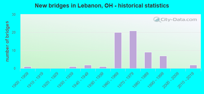
- New bridges - historical statistics
- 11900-1909
- 11930-1939
- 21940-1949
- 11950-1959
- 201960-1969
- 211970-1979
- 91980-1989
- 71990-1999
- 22010-2019

- Reconstructed bridges - Historical Statistics
- 21970-1979
- 21980-1989
- 61990-1999
- 42000-2009
- 12010-2019


- Bridge Condition - Deck
- 4.2%Excellent
- 22.9%Very good
- 33.3%Good
- 25.0%Satisfactory
- 12.5%Fair
- 2.1%Poor

- Bridge Condition - Superstructure
- 4.2%Excellent
- 29.2%Very good
- 25.0%Good
- 29.2%Satisfactory
- 10.4%Fair
- 2.1%Poor

- Bridge Condition - Substructure
- 2.1%Excellent
- 27.1%Very good
- 39.6%Good
- 18.8%Satisfactory
- 8.3%Fair
- 4.2%Poor

- Bridge Condition - Channel
- 2.1%Excellent
- 38.3%Very good
- 23.4%Good
- 29.8%Satisfactory
- 4.3%Fair
- 2.1%Poor

- Bridge Condition - Culverts
- 50.0%Good
- 16.7%Satisfactory
- 16.7%Fair
- 16.7%Serious
Find on map >> Show street view
Structure Number: 833533, Location: .42 MI.N.OF RIPLEY CORP. (Lat: 38.757211, Lng: -83.829450), Route carried "on" structure: County highway C0062, Year Built: 1948, Status: Posted for load, Structure Length: 3.44m (11.29ft), Average Daily Traffic: 268 (year 2015), Truck Traffic: 5%, Average Future Daily Traffic: 372 (year 2035), Design Load: HS 15, Features Intersected: RED OAK CREEK, Facility Carried by Structure: RIPLEY RD
Minimum Vertical Clearance: 30+ m (98+ ft), Kilometerpoint: 0.676, Lanes on structure: 2, Owner: County Highway Agency, Approaching Roadway Width: 10.4m (34.1ft), Skew: 1 degrees, Material/Design: Steel continuous, Design/Construction: Stringer/Multi-beam, Number Of Spans In Main Unit: 2, Length of Maximum Span: 17.1m (56.1ft), Curb or Sidewalk Widths: Left: 0.9m (3.0ft), Right: 0.9m (3.0ft), Curb-To-Curb Width: 8.6m (28.2ft), Out-to-Out Width: 10.3m (33.8ft)
Condition: Deck: Fair, Superstructure: Fair, Substructure: Poor, Channel: Very good, Operating Rating: 25.9 metric tons, Method Used To Determine Operating Rating: Load Factor (LF) rating reported by rating factor (RF) method using MS18 loading, Inventory Rating: 16.2 metric tons, Method Used To Determine Inventory Rating: Load Factor (LF) rating reported by rating factor (RF) method using MS18 loading, Structural Evaluation: Meets minimum limits, Deck Geometry: Equal to present minimum criteria, Waterway Adequacy: Equal to present desirable criteria, Approach Roadway Alignment: Equal to present desirable criteria, Bridge Posting: Required (Relationship of Operating Rating to Maximum Legal Load: 30.0 - 39.9% below), Designated Inspection Frequency: Every 12 months, Inspection Date: November 2021, Deck Structure Type: Concrete Cast-file-Place, Wearing Surface/Protective System: Wearing Surface: Bituminous
Find on map >> Show street view
Structure Number: 8300518, Location: 1.4 MI S LEBANON SW CORP (Lat: 39.395761, Lng: -84.261711), Route carried "on" structure: US 42, Year Built: 1932, Year Reconstructed: 1984, Status: Open, Structure Length: 2.01m (6.59ft), Average Daily Traffic: 6,134 (year 2015), Truck Traffic: 5%, Average Future Daily Traffic: 8,514 (year 2035), Design Load: HS 20, Features Intersected: LITTLE MUDDY CREEK
Minimum Vertical Clearance: 30+ m (98+ ft), Kilometerpoint: 10.557, Lanes on structure: 2, Base Highway Network: Yes, Owner: State Highway Agency, Approaching Roadway Width: 9.1m (29.9ft), Skew: 1 degrees, Material/Design: Prestressed concrete, Design/Construction: Box Beam or Girders - Multiple, Number Of Spans In Main Unit: 2, Length of Maximum Span: 9.4m (30.8ft), Curb-To-Curb Width: 9.2m (30.2ft), Out-to-Out Width: 9.2m (30.2ft)
Condition: Deck: Very good, Superstructure: Very good, Substructure: Good, Channel: Satisfactory, Operating Rating: 42.1 metric tons, Method Used To Determine Operating Rating: Load Factor (LF) rating reported by rating factor (RF) method using MS18 loading, Inventory Rating: 32.4 metric tons, Method Used To Determine Inventory Rating: Load Factor (LF) rating reported by rating factor (RF) method using MS18 loading, Structural Evaluation: Better than present minimum criteria, Deck Geometry: High priority of corrective action, Waterway Adequacy: Equal to present desirable criteria, Approach Roadway Alignment: Equal to present desirable criteria, Length Of Structure Improvement: 2.13m (6.99ft), Designated Inspection Frequency: Every 24 months, Inspection Date: April 2021, Bridge Improvement Cost: $170,000, Roadway Improvement Cost: $17,000, Total Project Cost: $292,000, Deck Structure Type: Concrete Cast-file-Place, Wearing Surface/Protective System: Wearing Surface: Bituminous
Find on map >> Show street view
Structure Number: 830055, Location: .5 MI N LEBANON SW CORP (Lat: 39.415381, Lng: -84.240239), Route carried "on" structure: US 42, Year Built: 1985, Status: Open, Structure Length: 4.11m (13.48ft), Average Daily Traffic: 6,134 (year 2015), Truck Traffic: 5%, Average Future Daily Traffic: 8,514 (year 2035), Design Load: HS 20+Mod, Features Intersected: TURTLE CREEK
Minimum Vertical Clearance: 30+ m (98+ ft), Kilometerpoint: 13.551, Lanes on structure: 2, Base Highway Network: Yes, Owner: State Highway Agency, Approaching Roadway Width: 11.0m (36.1ft), Skew: 2 degrees, Material/Design: Prestressed concrete continuous, Design/Construction: Box Beam or Girders - Multiple, Number Of Spans In Main Unit: 2, Length of Maximum Span: 20.1m (65.9ft), Curb-To-Curb Width: 11.0m (36.1ft), Out-to-Out Width: 11.0m (36.1ft)
Condition: Deck: Good, Superstructure: Good, Substructure: Very good, Channel: Good, Operating Rating: 77.8 metric tons, Method Used To Determine Operating Rating: Load Factor (LF) rating reported by rating factor (RF) method using MS18 loading, Inventory Rating: 45.4 metric tons, Method Used To Determine Inventory Rating: Load Factor (LF) rating reported by rating factor (RF) method using MS18 loading, Structural Evaluation: Better than present minimum criteria, Deck Geometry: Meets minimum limits, Waterway Adequacy: Equal to present desirable criteria, Approach Roadway Alignment: Equal to present desirable criteria, Designated Inspection Frequency: Every 24 months, Inspection Date: May 2021, Deck Structure Type: Concrete Cast-file-Place, Wearing Surface/Protective System: Wearing Surface: Bituminous
Find on map >> Show street view
Structure Number: 8300585, Location: .7 MI S OF SR 63 (Lat: 39.429300, Lng: -84.219331), Route carried "on" structure: US 42, Year Built: 1989, Status: Open, Structure Length: 0.85m (2.79ft), Average Daily Traffic: 6,134 (year 2015), Truck Traffic: 5%, Average Future Daily Traffic: 8,514 (year 2035), Design Load: HS 20+Mod, Features Intersected: TRB TURTL CR(BAINUMS CR)
Minimum Vertical Clearance: 30+ m (98+ ft), Kilometerpoint: 16.013, Lanes on structure: 2, Base Highway Network: Yes, Owner: State Highway Agency, Approaching Roadway Width: 7.3m (24.0ft), Skew: 1 degrees, Material/Design: Concrete, Design/Construction: Slab, Number Of Spans In Main Unit: 1, Length of Maximum Span: 8.5m (27.9ft), Curb-To-Curb Width: 11.0m (36.1ft), Out-to-Out Width: 11.6m (38.1ft)
Condition: Deck: Good, Superstructure: Good, Substructure: Satisfactory, Channel: Satisfactory, Operating Rating: 74.5 metric tons, Method Used To Determine Operating Rating: Load Factor (LF) rating reported by rating factor (RF) method using MS18 loading, Inventory Rating: 45.4 metric tons, Method Used To Determine Inventory Rating: Load Factor (LF) rating reported by rating factor (RF) method using MS18 loading, Structural Evaluation: Equal to present minimum criteria, Deck Geometry: Meets minimum limits, Waterway Adequacy: Equal to present desirable criteria, Approach Roadway Alignment: Equal to present desirable criteria, Designated Inspection Frequency: Every 12 months, Inspection Date: June 2021, Deck Structure Type: Concrete Cast-file-Place, Wearing Surface/Protective System: Wearing Surface: Monolithic Concrete, Deck Protection: Epoxy Coated Reinforcing
Find on map >> Show street view
Structure Number: 8300615, Location: 0.09 MI. S. OF SR-63 (Lat: 39.431039, Lng: -84.210631), Route carried "on" structure: US 42, Year Built: 1991, Status: Open, Structure Length: 2.56m (8.40ft), Average Daily Traffic: 6,134 (year 2015), Truck Traffic: 5%, Average Future Daily Traffic: 8,514 (year 2035), Design Load: HS 20+Mod, Features Intersected: TURTLE CREEK
Minimum Vertical Clearance: 30+ m (98+ ft), Kilometerpoint: 16.785, Lanes on structure: 2, Base Highway Network: Yes, Owner: State Highway Agency, Approaching Roadway Width: 11.0m (36.1ft), Skew: 5 degrees, Material/Design: Steel, Design/Construction: Stringer/Multi-beam, Number Of Spans In Main Unit: 1, Length of Maximum Span: 25.6m (84.0ft), Curb or Sidewalk Widths: Left: 0.0m, Right: 1.5m (4.9ft), Curb-To-Curb Width: 11.0m (36.1ft), Out-to-Out Width: 13.3m (43.6ft)
Condition: Deck: Good, Superstructure: Good, Substructure: Good, Channel: Good, Operating Rating: 42.1 metric tons, Method Used To Determine Operating Rating: Load Factor (LF) rating reported by rating factor (RF) method using MS18 loading, Inventory Rating: 32.4 metric tons, Method Used To Determine Inventory Rating: Load Factor (LF) rating reported by rating factor (RF) method using MS18 loading, Structural Evaluation: Better than present minimum criteria, Deck Geometry: Meets minimum limits, Waterway Adequacy: Superior to present desirable criteria, Approach Roadway Alignment: Equal to present minimum criteria, Designated Inspection Frequency: Every 24 months, Inspection Date: June 2021, Deck Structure Type: Concrete Cast-file-Place, Wearing Surface/Protective System: Wearing Surface: Monolithic Concrete, Membrane: Built-up, Deck Protection: Epoxy Coated Reinforcing
Find on map >> Show street view
Structure Number: 8301174, Location: .4 MI N LEBANON S CORP (Lat: 39.405500, Lng: -84.208000), Route carried "on" structure: City street M0077, Year Built: 1971, Status: Open, Structure Length: 7.13m (23.39ft), Average Daily Traffic: 1,295 (year 2015), Truck Traffic: 5%, Average Future Daily Traffic: 44,000 (year 2035), Design Load: HS 20, Features Intersected: S48, Facility Carried by Structure: TURTLECREEK UNION
Minimum Vertical Clearance: 30+ m (98+ ft), Kilometerpoint: 16.093, Lanes on structure: 2, Lanes under structure: 4, Owner: State Highway Agency, Approaching Roadway Width: 13.4m (44.0ft), Skew: 3 degrees, Material/Design: Steel continuous, Design/Construction: Stringer/Multi-beam, Number Of Spans In Main Unit: 4, Length of Maximum Span: 19.2m (63.0ft), Curb-To-Curb Width: 13.0m (42.7ft), Out-to-Out Width: 14.1m (46.3ft)
Condition: Deck: Fair, Superstructure: Satisfactory, Substructure: Good, Operating Rating: 42.1 metric tons, Method Used To Determine Operating Rating: Load Factor (LF) rating reported by rating factor (RF) method using MS18 loading, Inventory Rating: 29.2 metric tons, Method Used To Determine Inventory Rating: Load Factor (LF) rating reported by rating factor (RF) method using MS18 loading, Structural Evaluation: Equal to present minimum criteria, Deck Geometry: Better than present minimum criteria, Underclear: High priority of corrective action, Approach Roadway Alignment: Superior to present desirable criteria, Designated Inspection Frequency: Every 12 months, Inspection Date: August 2021, Deck Structure Type: Concrete Cast-file-Place, Wearing Surface/Protective System: Wearing Surface: Monolithic Concrete
Find on map >> Show street view
Structure Number: 8301204, Location: .2 MI S OF SR 48F (Lat: 39.430111, Lng: -84.191950), Route carried "on" structure: State highway 48, Year Built: 1970, Status: Open, Structure Length: 0.94m (3.08ft), Average Daily Traffic: 30,307 (year 2015), Truck Traffic: 5%, Average Future Daily Traffic: 42,066 (year 2035), Design Load: H 20, Features Intersected: TURTLE CREEK
Minimum Vertical Clearance: 30+ m (98+ ft), Kilometerpoint: 21.662, Lanes on structure: 4, Base Highway Network: Yes, Owner: State Highway Agency, Approaching Roadway Width: 44.2m (145.0ft), Skew: 21 degrees, Material/Design: Concrete, Design/Construction: Culvert, Number Of Spans In Main Unit: 2, Length of Maximum Span: 4.3m (14.1ft)
Condition: Channel: Good, Culverts: Satisfactory, Operating Rating: 42.1 metric tons, Method Used To Determine Operating Rating: Load Factor (LF) rating reported by rating factor (RF) method using MS18 loading, Inventory Rating: 32.4 metric tons, Method Used To Determine Inventory Rating: Load Factor (LF) rating reported by rating factor (RF) method using MS18 loading, Structural Evaluation: Equal to present minimum criteria, Waterway Adequacy: Superior to present desirable criteria, Approach Roadway Alignment: Superior to present desirable criteria, Designated Inspection Frequency: Every 12 months, Inspection Date: September 2021
Find on map >> Show street view
Structure Number: 8301263, Location: .15 MI N OF JCT US42 (Lat: 39.438739, Lng: -84.207831), Route carried "on" structure: State highway 48, Year Built: 1973, Status: Open, Structure Length: 1.46m (4.79ft), Average Daily Traffic: 10,791 (year 2015), Truck Traffic: 5%, Average Future Daily Traffic: 14,978 (year 2035), Design Load: HS 20, Features Intersected: NORTH FORK TURTLE CREEK
Minimum Vertical Clearance: 30+ m (98+ ft), Kilometerpoint: 24.269, Lanes on structure: 4, Base Highway Network: Yes, Owner: State Highway Agency, Approaching Roadway Width: 19.8m (65.0ft), Skew: 1 degrees, Material/Design: Steel, Design/Construction: Culvert, Number Of Spans In Main Unit: 2, Length of Maximum Span: 6.1m (20.0ft)
Condition: Channel: Satisfactory, Culverts: Serious, Operating Rating: 42.1 metric tons, Method Used To Determine Operating Rating: Load Factor (LF) rating reported by rating factor (RF) method using MS18 loading, Inventory Rating: 32.4 metric tons, Method Used To Determine Inventory Rating: Load Factor (LF) rating reported by rating factor (RF) method using MS18 loading, Structural Evaluation: High priority of corrective action, Waterway Adequacy: Superior to present desirable criteria, Approach Roadway Alignment: Superior to present desirable criteria, Designated Inspection Frequency: Every 12 months, Inspection Date: September 2021
Find on map >> Show street view
Structure Number: 830153, Location: 2 MI E OF JCT SR741 (Lat: 39.435489, Lng: -84.241600), Route carried "on" structure: State highway 63, Year Built: 1950, Status: Open, Structure Length: 0.88m (2.89ft), Average Daily Traffic: 12,180 (year 2015), Truck Traffic: 9%, Average Future Daily Traffic: 16,906 (year 2035), Design Load: HS 25 or greater, Features Intersected: TRB TURT CR(MULFORDS RN)
Minimum Vertical Clearance: 30+ m (98+ ft), Kilometerpoint: 8.369, Lanes on structure: 2, Owner: State Highway Agency, Approaching Roadway Width: 11.1m (36.4ft), Skew: 2 degrees, Material/Design: Concrete, Design/Construction: Slab, Number Of Spans In Main Unit: 1, Length of Maximum Span: 8.2m (26.9ft), Curb-To-Curb Width: 11.0m (36.1ft), Out-to-Out Width: 11.1m (36.4ft)
Condition: Deck: Very good, Superstructure: Very good, Substructure: Good, Channel: Satisfactory, Operating Rating: 84.2 metric tons, Method Used To Determine Operating Rating: Load Factor (LF) rating reported by rating factor (RF) method using MS18 loading, Inventory Rating: 48.6 metric tons, Method Used To Determine Inventory Rating: Load Factor (LF) rating reported by rating factor (RF) method using MS18 loading, Structural Evaluation: Better than present minimum criteria, Deck Geometry: Meets minimum limits, Waterway Adequacy: Equal to present desirable criteria, Approach Roadway Alignment: Better than present minimum criteria, Designated Inspection Frequency: Every 24 months, Inspection Date: November 2021, Deck Structure Type: Concrete Cast-file-Place, Wearing Surface/Protective System: Wearing Surface: Epoxy Overlay, Membrane: Epoxy, Deck Protection: Epoxy Coated Reinforcing
Find on map >> Show street view
Structure Number: 8301565, Location: 1.25 MI W OF JCT US 42 (Lat: 39.434839, Lng: -84.231381), Route carried "on" structure: State highway 63, Year Built: 1947, Year Reconstructed: 1976, Status: Open, Structure Length: 1.49m (4.89ft), Average Daily Traffic: 12,221 (year 2015), Truck Traffic: 9%, Average Future Daily Traffic: 16,963 (year 2035), Design Load: HS 20+Mod, Features Intersected: TRB TURTL CR(REEDERS RN)
Minimum Vertical Clearance: 30+ m (98+ ft), Kilometerpoint: 9.254, Lanes on structure: 2, Owner: State Highway Agency, Approaching Roadway Width: 6.1m (20.0ft), Material/Design: Prestressed concrete, Design/Construction: Box Beam or Girders - Multiple, Number Of Spans In Main Unit: 1, Length of Maximum Span: 14.3m (46.9ft), Curb-To-Curb Width: 8.2m (26.9ft), Out-to-Out Width: 8.7m (28.5ft)
Condition: Deck: Satisfactory, Superstructure: Satisfactory, Substructure: Satisfactory, Channel: Good, Operating Rating: 42.1 metric tons, Method Used To Determine Operating Rating: Load Factor (LF) rating reported by rating factor (RF) method using MS18 loading, Inventory Rating: 32.4 metric tons, Method Used To Determine Inventory Rating: Load Factor (LF) rating reported by rating factor (RF) method using MS18 loading, Structural Evaluation: Equal to present minimum criteria, Deck Geometry: High priority of replacement, Waterway Adequacy: Equal to present desirable criteria, Approach Roadway Alignment: Superior to present desirable criteria, Designated Inspection Frequency: Every 12 months, Inspection Date: December 2021, Deck Structure Type: Concrete Cast-file-Place, Wearing Surface/Protective System: Wearing Surface: Bituminous, Membrane: Built-up
Find on map >> Show street view
Structure Number: 8301662, Location: 0.2 MI W OF JCT US 42. (Lat: 39.433581, Lng: -84.211700), Route carried "on" structure: State highway 63, Year Built: 1997, Status: Open, Structure Length: 2.72m (8.92ft), Average Daily Traffic: 12,594 (year 2015), Truck Traffic: 8%, Average Future Daily Traffic: 17,480 (year 2035), Design Load: HS 20+Mod, Features Intersected: N FORK OF TURTLE CREEK
Minimum Vertical Clearance: 30+ m (98+ ft), Kilometerpoint: 10.992, Lanes on structure: 2, Owner: State Highway Agency, Approaching Roadway Width: 12.0m (39.4ft), Material/Design: Prestressed concrete, Design/Construction: Box Beam or Girders - Multiple, Number Of Spans In Main Unit: 1, Length of Maximum Span: 26.9m (88.3ft), Curb or Sidewalk Widths: Left: 1.8m (5.9ft), Right: 1.8m (5.9ft), Curb-To-Curb Width: 12.0m (39.4ft), Out-to-Out Width: 16.3m (53.5ft)
Condition: Deck: Very good, Superstructure: Very good, Substructure: Very good, Channel: Very good, Operating Rating: 42.1 metric tons, Method Used To Determine Operating Rating: Load Factor (LF) rating reported by rating factor (RF) method using MS18 loading, Inventory Rating: 32.4 metric tons, Method Used To Determine Inventory Rating: Load Factor (LF) rating reported by rating factor (RF) method using MS18 loading, Structural Evaluation: Equal to present desirable criteria, Deck Geometry: Somewhat better than minimum adequacy, Waterway Adequacy: Equal to present desirable criteria, Approach Roadway Alignment: Equal to present desirable criteria, Designated Inspection Frequency: Every 24 months, Inspection Date: December 2021, Deck Structure Type: Concrete Cast-file-Place, Wearing Surface/Protective System: Wearing Surface: Monolithic Concrete, Deck Protection: Epoxy Coated Reinforcing
Find on map >> Show street view
Structure Number: 8301921, Location: 1.2 MI N OF SR 741 (Lat: 39.371019, Lng: -84.250039), Route carried "on" structure: Interstate 71, Year Built: 1964, Year Reconstructed: 2001, Status: Open, Structure Length: 8.46m (27.76ft), Average Daily Traffic: 31,629 (year 2015), Truck Traffic: 11%, Average Future Daily Traffic: 43,901 (year 2035), Design Load: HS 20+Mod, Features Intersected: C15(C38);MUDDY CREEK
Minimum Vertical Clearance: 30+ m (98+ ft), Kilometerpoint: 10.573, Lanes on structure: 3, Lanes under structure: 2, Base Highway Network: Yes, Owner: State Highway Agency, Approaching Roadway Width: 18.7m (61.4ft), Material/Design: Steel continuous, Design/Construction: Stringer/Multi-beam, Number Of Spans In Main Unit: 3, Length of Maximum Span: 32.0m (105.0ft), Curb-To-Curb Width: 18.7m (61.4ft), Out-to-Out Width: 19.6m (64.3ft)
Condition: Deck: Good, Superstructure: Very good, Substructure: Good, Channel: Satisfactory, Operating Rating: 58.3 metric tons, Method Used To Determine Operating Rating: Load and Resistance Factor Rating (LRFR) rating reported by rating factor(RF) method using HL-93 loadings, Inventory Rating: 45.4 metric tons, Method Used To Determine Inventory Rating: Load and Resistance Factor Rating (LRFR) rating reported by rating factor(RF) method using HL-93 loadings, Structural Evaluation: Better than present minimum criteria, Deck Geometry: Superior to present desirable criteria, Underclear: Meets minimum limits, Waterway Adequacy: Superior to present desirable criteria, Approach Roadway Alignment: Equal to present desirable criteria, Designated Inspection Frequency: Every 24 months, Inspection Date: August 2021, Deck Structure Type: Concrete Cast-file-Place, Wearing Surface/Protective System: Wearing Surface: Monolithic Concrete, Deck Protection: Epoxy Coated Reinforcing
Find on map >> Show street view
Structure Number: 8301956, Location: 1.2 MI N OF SR 741 (Lat: 39.370850, Lng: -84.249769), Route carried "on" structure: Interstate 71, Year Built: 1964, Year Reconstructed: 2001, Status: Open, Structure Length: 8.46m (27.76ft), Average Daily Traffic: 31,629 (year 2015), Truck Traffic: 11%, Average Future Daily Traffic: 43,901 (year 2035), Design Load: HS 20+Mod, Features Intersected: C15(C38);MUDDY CREEK
Minimum Vertical Clearance: 30+ m (98+ ft), Kilometerpoint: 10.573, Lanes on structure: 3, Lanes under structure: 2, Base Highway Network: Yes, Owner: State Highway Agency, Approaching Roadway Width: 18.7m (61.4ft), Material/Design: Steel continuous, Design/Construction: Stringer/Multi-beam, Number Of Spans In Main Unit: 3, Length of Maximum Span: 32.0m (105.0ft), Curb-To-Curb Width: 18.7m (61.4ft), Out-to-Out Width: 19.6m (64.3ft)
Condition: Deck: Very good, Superstructure: Very good, Substructure: Very good, Channel: Very good, Operating Rating: 58.3 metric tons, Method Used To Determine Operating Rating: Load and Resistance Factor Rating (LRFR) rating reported by rating factor(RF) method using HL-93 loadings, Inventory Rating: 45.4 metric tons, Method Used To Determine Inventory Rating: Load and Resistance Factor Rating (LRFR) rating reported by rating factor(RF) method using HL-93 loadings, Structural Evaluation: Equal to present desirable criteria, Deck Geometry: Superior to present desirable criteria, Underclear: Meets minimum limits, Waterway Adequacy: Equal to present desirable criteria, Approach Roadway Alignment: Equal to present desirable criteria, Designated Inspection Frequency: Every 24 months, Inspection Date: August 2021, Deck Structure Type: Concrete Cast-file-Place, Wearing Surface/Protective System: Wearing Surface: Monolithic Concrete, Deck Protection: Epoxy Coated Reinforcing
Find on map >> Show street view
Structure Number: 830198, Location: 1.4 MI N OF SR 741 (Lat: 39.373569, Lng: -84.247131), Route carried "on" structure: Interstate 71, Year Built: 1965, Year Reconstructed: 2001, Status: Open, Structure Length: 3.99m (13.09ft), Average Daily Traffic: 31,629 (year 2015), Truck Traffic: 11%, Average Future Daily Traffic: 43,901 (year 2035), Design Load: HS 20+Mod, Features Intersected: ABANDONED RAILWAY
Minimum Vertical Clearance: 30+ m (98+ ft), Kilometerpoint: 10.927, Lanes on structure: 3, Base Highway Network: Yes, Owner: State Highway Agency, Approaching Roadway Width: 18.7m (61.4ft), Skew: 2 degrees, Material/Design: Concrete continuous, Design/Construction: Slab, Number Of Spans In Main Unit: 3, Length of Maximum Span: 15.2m (49.9ft), Curb-To-Curb Width: 18.7m (61.4ft), Out-to-Out Width: 19.6m (64.3ft)
Condition: Deck: Good, Superstructure: Very good, Substructure: Good, Operating Rating: 58.3 metric tons, Method Used To Determine Operating Rating: Load Factor (LF) rating reported by rating factor (RF) method using MS18 loading, Inventory Rating: 35.6 metric tons, Method Used To Determine Inventory Rating: Load Factor (LF) rating reported by rating factor (RF) method using MS18 loading, Structural Evaluation: Better than present minimum criteria, Deck Geometry: Superior to present desirable criteria, Underclear: High priority of corrective action, Approach Roadway Alignment: Superior to present desirable criteria, Designated Inspection Frequency: Every 24 months, Inspection Date: Febuary 2021, Deck Structure Type: Concrete Cast-file-Place, Wearing Surface/Protective System: Wearing Surface: Integral Concrete
Find on map >> Show street view
Structure Number: 8302049, Location: .8 MI S OF SR 48 (Lat: 39.380061, Lng: -84.235781), Route carried "on" structure: Interstate 71, Year Built: 1965, Year Reconstructed: 2001, Status: Open, Structure Length: 9.85m (32.32ft), Average Daily Traffic: 31,629 (year 2015), Truck Traffic: 11%, Average Future Daily Traffic: 43,901 (year 2035), Design Load: HS 20+Mod, Features Intersected: TURTLE CR T72(TURTCR RD)
Minimum Vertical Clearance: 30+ m (98+ ft), Kilometerpoint: 12.183, Lanes on structure: 3, Lanes under structure: 2, Base Highway Network: Yes, Owner: State Highway Agency, Approaching Roadway Width: 18.7m (61.4ft), Skew: 3 degrees, Material/Design: Steel continuous, Design/Construction: Stringer/Multi-beam, Number Of Spans In Main Unit: 3, Length of Maximum Span: 37.2m (122.0ft), Curb-To-Curb Width: 18.7m (61.4ft), Out-to-Out Width: 19.6m (64.3ft)
Condition: Deck: Good, Superstructure: Good, Substructure: Good, Channel: Very good, Operating Rating: 51.8 metric tons, Method Used To Determine Operating Rating: Load and Resistance Factor Rating (LRFR) rating reported by rating factor(RF) method using HL-93 loadings, Inventory Rating: 42.1 metric tons, Method Used To Determine Inventory Rating: Load and Resistance Factor Rating (LRFR) rating reported by rating factor(RF) method using HL-93 loadings, Structural Evaluation: Better than present minimum criteria, Deck Geometry: Superior to present desirable criteria, Underclear: Meets minimum limits, Waterway Adequacy: Equal to present desirable criteria, Approach Roadway Alignment: Equal to present desirable criteria, Designated Inspection Frequency: Every 24 months, Inspection Date: September 2021, Deck Structure Type: Concrete Cast-file-Place, Wearing Surface/Protective System: Wearing Surface: Monolithic Concrete, Deck Protection: Epoxy Coated Reinforcing
Find on map >> Show street view
Structure Number: 8302073, Location: .8 MI S OF SR 48 (Lat: 39.379900, Lng: -84.235450), Route carried "on" structure: Interstate 71, Year Built: 1965, Year Reconstructed: 2001, Status: Open, Structure Length: 9.85m (32.32ft), Average Daily Traffic: 31,629 (year 2015), Truck Traffic: 11%, Average Future Daily Traffic: 43,901 (year 2035), Design Load: HS 20+Mod, Features Intersected: TURTLE CR T72(TURTCR RD)
Minimum Vertical Clearance: 30+ m (98+ ft), Kilometerpoint: 12.183, Lanes on structure: 3, Lanes under structure: 2, Base Highway Network: Yes, Owner: State Highway Agency, Approaching Roadway Width: 17.5m (57.4ft), Skew: 3 degrees, Material/Design: Steel continuous, Design/Construction: Stringer/Multi-beam, Number Of Spans In Main Unit: 3, Length of Maximum Span: 37.2m (122.0ft), Curb-To-Curb Width: 18.7m (61.4ft), Out-to-Out Width: 19.6m (64.3ft)
Condition: Deck: Good, Superstructure: Good, Substructure: Good, Channel: Very good, Operating Rating: 51.8 metric tons, Method Used To Determine Operating Rating: Load and Resistance Factor Rating (LRFR) rating reported by rating factor(RF) method using HL-93 loadings, Inventory Rating: 42.1 metric tons, Method Used To Determine Inventory Rating: Load and Resistance Factor Rating (LRFR) rating reported by rating factor(RF) method using HL-93 loadings, Structural Evaluation: Better than present minimum criteria, Deck Geometry: Superior to present desirable criteria, Underclear: Meets minimum limits, Waterway Adequacy: Equal to present desirable criteria, Approach Roadway Alignment: Equal to present desirable criteria, Designated Inspection Frequency: Every 24 months, Inspection Date: September 2021, Deck Structure Type: Concrete Cast-file-Place, Wearing Surface/Protective System: Wearing Surface: Monolithic Concrete, Deck Protection: Epoxy Coated Reinforcing
Find on map >> Show street view
Structure Number: 8302162, Location: 1.6 MI S OF SR 123 (Lat: 39.402881, Lng: -84.178289), Route carried "on" structure: County highway C0035, Year Built: 1964, Status: Open, Structure Length: 8.74m (28.67ft), Average Daily Traffic: 2,702 (year 2015), Truck Traffic: 5%, Average Future Daily Traffic: 61,452 (year 2035), Design Load: H 15, Features Intersected: I71, Facility Carried by Structure: STUBBS MILL RD C35
Minimum Vertical Clearance: 30+ m (98+ ft), Kilometerpoint: 5.673, Lanes on structure: 2, Lanes under structure: 4, Owner: State Highway Agency, Approaching Roadway Width: 8.8m (28.9ft), Skew: 1 degrees, Material/Design: Steel continuous, Design/Construction: Stringer/Multi-beam, Number Of Spans In Main Unit: 4, Length of Maximum Span: 25.3m (83.0ft), Curb-To-Curb Width: 7.3m (24.0ft), Out-to-Out Width: 9.4m (30.8ft)
Condition: Deck: Good, Superstructure: Satisfactory, Substructure: Good, Operating Rating: 42.1 metric tons, Method Used To Determine Operating Rating: Load Factor (LF) rating reported by rating factor (RF) method using MS18 loading, Inventory Rating: 32.4 metric tons, Method Used To Determine Inventory Rating: Load Factor (LF) rating reported by rating factor (RF) method using MS18 loading, Structural Evaluation: Equal to present minimum criteria, Deck Geometry: High priority of replacement, Underclear: Somewhat better than minimum adequacy, Approach Roadway Alignment: Superior to present desirable criteria, Designated Inspection Frequency: Every 12 months, Inspection Date: September 2021, Deck Structure Type: Concrete Cast-file-Place, Wearing Surface/Protective System: Wearing Surface: Latex Concrete
Find on map >> Show street view
Structure Number: 8302227, Location: 1 MI N OF SR 123 (Lat: 39.414261, Lng: -84.132989), Route carried "on" structure: City street M0039, Year Built: 1964, Status: Open, Structure Length: 8.74m (28.67ft), Average Daily Traffic: 763 (year 2015), Truck Traffic: 8%, Average Future Daily Traffic: 61,280 (year 2035), Design Load: H 15, Features Intersected: I71, Facility Carried by Structure: WAYNESVILLE RD T39
Minimum Vertical Clearance: 30+ m (98+ ft), Kilometerpoint: 59.707, Lanes on structure: 2, Lanes under structure: 4, Owner: State Highway Agency, Approaching Roadway Width: 8.8m (28.9ft), Material/Design: Steel continuous, Design/Construction: Stringer/Multi-beam, Number Of Spans In Main Unit: 4, Length of Maximum Span: 25.3m (83.0ft), Curb-To-Curb Width: 7.3m (24.0ft), Out-to-Out Width: 9.3m (30.5ft)
Condition: Deck: Good, Superstructure: Satisfactory, Substructure: Good, Operating Rating: 32.4 metric tons, Method Used To Determine Operating Rating: Load and Resistance Factor Rating (LRFR) rating reported by rating factor(RF) method using HL-93 loadings, Inventory Rating: 25.9 metric tons, Method Used To Determine Inventory Rating: Load and Resistance Factor Rating (LRFR) rating reported by rating factor(RF) method using HL-93 loadings, Structural Evaluation: Equal to present minimum criteria, Deck Geometry: Meets minimum limits, Underclear: High priority of corrective action, Approach Roadway Alignment: Equal to present desirable criteria, Designated Inspection Frequency: Every 12 months, Inspection Date: September 2021, Deck Structure Type: Concrete Cast-file-Place, Wearing Surface/Protective System: Wearing Surface: Latex Concrete
Find on map >> Show street view
Structure Number: 8304416, Location: OVER IR 71 (Lat: 39.412581, Lng: -84.152561), Route carried "on" structure: State highway 123, Year Built: 1964, Status: Open, Structure Length: 9.74m (31.96ft), Average Daily Traffic: 8,147 (year 2015), Truck Traffic: 10%, Average Future Daily Traffic: 11,308 (year 2035), Design Load: H 15, Features Intersected: I71
Minimum Vertical Clearance: 30+ m (98+ ft), Kilometerpoint: 24.124, Lanes on structure: 4, Lanes under structure: 4, Owner: State Highway Agency, Approaching Roadway Width: 19.5m (64.0ft), Skew: 22 degrees, Material/Design: Steel continuous, Design/Construction: Stringer/Multi-beam, Number Of Spans In Main Unit: 4, Length of Maximum Span: 28.2m (92.5ft), Curb-To-Curb Width: 19.1m (62.7ft), Out-to-Out Width: 20.0m (65.6ft)
Condition: Deck: Satisfactory, Superstructure: Good, Substructure: Good, Operating Rating: 42.1 metric tons, Method Used To Determine Operating Rating: Load Factor (LF) rating reported by rating factor (RF) method using MS18 loading, Inventory Rating: 32.4 metric tons, Method Used To Determine Inventory Rating: Load Factor (LF) rating reported by rating factor (RF) method using MS18 loading, Structural Evaluation: Better than present minimum criteria, Deck Geometry: Equal to present minimum criteria, Underclear: Somewhat better than minimum adequacy, Approach Roadway Alignment: Better than present minimum criteria, Designated Inspection Frequency: Every 12 months, Inspection Date: May 2021, Deck Structure Type: Concrete Cast-file-Place, Wearing Surface/Protective System: Wearing Surface: Integral Concrete, Deck Protection: Epoxy Coated Reinforcing
Find on map >> Show street view
Structure Number: 8304432, Location: 100 FT EAST OF 48/123 JCT (Lat: 39.431139, Lng: -84.188169), Route carried "on" structure: State highway 123, Year Built: 1993, Status: Open, Structure Length: 3.70m (12.14ft), Average Daily Traffic: 14,404 (year 2015), Truck Traffic: 10%, Average Future Daily Traffic: 19,993 (year 2035), Design Load: HS 20+Mod, Features Intersected: TURTLE CREEK
Minimum Vertical Clearance: 30+ m (98+ ft), Kilometerpoint: 28.003, Lanes on structure: 2, Owner: State Highway Agency, Approaching Roadway Width: 19.5m (64.0ft), Skew: 2 degrees, Material/Design: Prestressed concrete continuous, Design/Construction: Box Beam or Girders - Multiple, Number Of Spans In Main Unit: 3, Length of Maximum Span: 11.9m (39.0ft), Curb-To-Curb Width: 19.5m (64.0ft), Out-to-Out Width: 19.5m (64.0ft)
Condition: Deck: Very good, Superstructure: Very good, Substructure: Very good, Channel: Good, Operating Rating: 55.1 metric tons, Method Used To Determine Operating Rating: Load Factor (LF) rating reported by rating factor (RF) method using MS18 loading, Inventory Rating: 32.4 metric tons, Method Used To Determine Inventory Rating: Load Factor (LF) rating reported by rating factor (RF) method using MS18 loading, Structural Evaluation: Equal to present desirable criteria, Deck Geometry: Superior to present desirable criteria, Waterway Adequacy: Superior to present desirable criteria, Approach Roadway Alignment: Equal to present desirable criteria, Designated Inspection Frequency: Every 24 months, Inspection Date: May 2021, Deck Structure Type: Concrete Cast-file-Place, Wearing Surface/Protective System: Wearing Surface: Bituminous
Find on map >> Show street view
Structure Number: 8304475, Location: 85' West of Sycamore St (Lat: 39.435611, Lng: -84.210200), Route carried "on" structure: City street MR340, Year Built: 1971, Status: Open, Structure Length: 2.04m (6.69ft), Average Daily Traffic: 8,460 (year 2015), Truck Traffic: 5%, Average Future Daily Traffic: 11,742 (year 2035), Design Load: H 20, Features Intersected: NORTH FORK TURTLE CREEK, Facility Carried by Structure: Silver Street
Minimum Vertical Clearance: 30+ m (98+ ft), Kilometerpoint: 30.207, Lanes on structure: 2, Owner: City or Municipal Highway Agency, Approaching Roadway Width: 12.2m (40.0ft), Skew: 2 degrees, Material/Design: Concrete continuous, Design/Construction: Slab, Number Of Spans In Main Unit: 3, Length of Maximum Span: 7.6m (24.9ft), Curb or Sidewalk Widths: Left: 1.6m (5.2ft), Right: 1.6m (5.2ft), Curb-To-Curb Width: 12.2m (40.0ft), Out-to-Out Width: 16.1m (52.8ft)
Condition: Deck: Good, Superstructure: Good, Substructure: Good, Channel: Satisfactory, Operating Rating: 51.8 metric tons, Method Used To Determine Operating Rating: Load Factor (LF) rating reported by rating factor (RF) method using MS18 loading, Inventory Rating: 32.4 metric tons, Method Used To Determine Inventory Rating: Load Factor (LF) rating reported by rating factor (RF) method using MS18 loading, Structural Evaluation: Better than present minimum criteria, Deck Geometry: Somewhat better than minimum adequacy, Waterway Adequacy: Superior to present desirable criteria, Approach Roadway Alignment: Equal to present desirable criteria, Designated Inspection Frequency: Every 24 months, Inspection Date: May 2021, Deck Structure Type: Concrete Cast-file-Place, Wearing Surface/Protective System: Wearing Surface: Integral Concrete
Find on map >> Show street view
Structure Number: 830556, Location: OVER SR 48 & 123 (Lat: 39.431900, Lng: -84.190581), Route carried "on" structure: State highway 48T, Year Built: 1971, Status: Open, Structure Length: 6.25m (20.51ft), Average Daily Traffic: 12,996 (year 2015), Truck Traffic: 4%, Average Future Daily Traffic: 18,038 (year 2035), Design Load: H 20, Features Intersected: S123*S;S48*N(S123*N), Facility Carried by Structure: SB SR 48F
Minimum Vertical Clearance: 30+ m (98+ ft), Kilometerpoint: 0.209, Lanes on structure: 2, Lanes under structure: 5, Base Highway Network: Yes, Owner: State Highway Agency, Approaching Roadway Width: 17.7m (58.1ft), Skew: 2 degrees, Material/Design: Steel continuous, Design/Construction: Stringer/Multi-beam, Number Of Spans In Main Unit: 3, Length of Maximum Span: 25.9m (85.0ft), Curb-To-Curb Width: 11.6m (38.1ft), Out-to-Out Width: 12.9m (42.3ft)
Condition: Deck: Very good, Superstructure: Very good, Substructure: Very good, Operating Rating: 42.1 metric tons, Method Used To Determine Operating Rating: Load Factor (LF) rating reported by rating factor (RF) method using MS18 loading, Inventory Rating: 32.4 metric tons, Method Used To Determine Inventory Rating: Load Factor (LF) rating reported by rating factor (RF) method using MS18 loading, Structural Evaluation: Equal to present desirable criteria, Deck Geometry: Better than present minimum criteria, Underclear: Equal to present minimum criteria, Approach Roadway Alignment: Superior to present desirable criteria, Designated Inspection Frequency: Every 24 months, Inspection Date: August 2021, Deck Structure Type: Concrete Cast-file-Place, Wearing Surface/Protective System: Wearing Surface: Integral Concrete
Find on map >> Show street view
Structure Number: 8305579, Location: OVER SR 48 & 123 (Lat: 39.431850, Lng: -84.190339), Route carried "on" structure: State highway 48T, Year Built: 1971, Status: Open, Structure Length: 6.25m (20.51ft), Average Daily Traffic: 12,996 (year 2015), Truck Traffic: 4%, Average Future Daily Traffic: 18,038 (year 2035), Design Load: H 20, Features Intersected: S123*S;S48*N(S123*N), Facility Carried by Structure: NB SR 48F
Minimum Vertical Clearance: 30+ m (98+ ft), Kilometerpoint: 0.209, Lanes on structure: 2, Lanes under structure: 5, Base Highway Network: Yes, Owner: State Highway Agency, Approaching Roadway Width: 17.7m (58.1ft), Skew: 2 degrees, Material/Design: Steel continuous, Design/Construction: Stringer/Multi-beam, Number Of Spans In Main Unit: 3, Length of Maximum Span: 25.9m (85.0ft), Curb or Sidewalk Widths: Left: 0.2m (0.7ft), Right: 0.2m (0.7ft), Curb-To-Curb Width: 14.6m (47.9ft), Out-to-Out Width: 15.9m (52.2ft)
Condition: Deck: Good, Superstructure: Very good, Substructure: Very good, Operating Rating: 42.1 metric tons, Method Used To Determine Operating Rating: Load Factor (LF) rating reported by rating factor (RF) method using MS18 loading, Inventory Rating: 32.4 metric tons, Method Used To Determine Inventory Rating: Load Factor (LF) rating reported by rating factor (RF) method using MS18 loading, Structural Evaluation: Equal to present desirable criteria, Deck Geometry: Superior to present desirable criteria, Underclear: Meets minimum limits, Approach Roadway Alignment: Superior to present desirable criteria, Designated Inspection Frequency: Every 24 months, Inspection Date: August 2021, Deck Structure Type: Concrete Cast-file-Place, Wearing Surface/Protective System: Wearing Surface: Integral Concrete
Find on map >> Show street view
Structure Number: 8330018, Location: 0.12 mi N of TR 95 (Lat: 39.443961, Lng: -84.158400), Route carried "on" structure: County highway C0012, Year Built: 1999, Status: Open, Structure Length: 1.28m (4.20ft), Average Daily Traffic: 1,132 (year 2015), Truck Traffic: 8%, Average Future Daily Traffic: 1,571 (year 2035), Design Load: HS 20, Features Intersected: BRANCH OF TURTLECREEK, Facility Carried by Structure: OREGONIA RD.
Minimum Vertical Clearance: 30+ m (98+ ft), Kilometerpoint: 3.058, Lanes on structure: 2, Owner: County Highway Agency, Approaching Roadway Width: 7.3m (24.0ft), Material/Design: Prestressed concrete, Design/Construction: Box Beam or Girders - Multiple, Number Of Spans In Main Unit: 1, Length of Maximum Span: 11.9m (39.0ft), Curb-To-Curb Width: 8.5m (27.9ft), Out-to-Out Width: 8.5m (27.9ft)
Condition: Deck: Satisfactory, Superstructure: Satisfactory, Substructure: Very good, Channel: Good, Operating Rating: 90.7 metric tons, Method Used To Determine Operating Rating: Load Factor (LF) rating reported by rating factor (RF) method using MS18 loading, Inventory Rating: 55.1 metric tons, Method Used To Determine Inventory Rating: Load Factor (LF) rating reported by rating factor (RF) method using MS18 loading, Structural Evaluation: Equal to present minimum criteria, Deck Geometry: Somewhat better than minimum adequacy, Waterway Adequacy: Equal to present desirable criteria, Approach Roadway Alignment: Equal to present desirable criteria, Designated Inspection Frequency: Every 12 months, Inspection Date: December 2021, Deck Structure Type: Other, Wearing Surface/Protective System: Wearing Surface: Bituminous
Find on map >> Show street view
Structure Number: 8330034, Location: 0.57 mi S of TR 95 (Lat: 39.437411, Lng: -84.168261), Route carried "on" structure: County highway C0012, Year Built: 1970, Year Reconstructed: 1991, Status: Open, Structure Length: 0.82m (2.69ft), Average Daily Traffic: 1,132 (year 2015), Truck Traffic: 8%, Average Future Daily Traffic: 1,571 (year 2035), Design Load: HS 20, Features Intersected: BRANCH OF TURTLE CREEK, Facility Carried by Structure: OREGONIA ROAD
Minimum Vertical Clearance: 30+ m (98+ ft), Kilometerpoint: 1.931, Lanes on structure: 2, Owner: County Highway Agency, Approaching Roadway Width: 7.3m (24.0ft), Skew: 2 degrees, Material/Design: Prestressed concrete, Design/Construction: Box Beam or Girders - Multiple, Number Of Spans In Main Unit: 1, Length of Maximum Span: 7.9m (25.9ft), Curb-To-Curb Width: 7.3m (24.0ft), Out-to-Out Width: 7.3m (24.0ft)
Condition: Deck: Satisfactory, Superstructure: Satisfactory, Substructure: Poor, Channel: Fair, Operating Rating: 97.2 metric tons, Method Used To Determine Operating Rating: Load Factor (LF) rating reported by rating factor (RF) method using MS18 loading, Inventory Rating: 68.0 metric tons, Method Used To Determine Inventory Rating: Load Factor (LF) rating reported by rating factor (RF) method using MS18 loading, Structural Evaluation: Meets minimum limits, Deck Geometry: Meets minimum limits, Waterway Adequacy: Better than present minimum criteria, Approach Roadway Alignment: Equal to present desirable criteria, Designated Inspection Frequency: Every 12 months, Inspection Date: December 2021, Deck Structure Type: Concrete Cast-file-Place, Wearing Surface/Protective System: Wearing Surface: Bituminous
Find on map >> Show street view
Structure Number: 8330042, Location: 0.43 mi S of TR 95 (Lat: 39.438711, Lng: -84.166261), Route carried "on" structure: County highway C0012, Year Built: 1970, Year Reconstructed: 2012, Status: Open, Structure Length: 0.98m (3.22ft), Average Daily Traffic: 1,132 (year 2015), Truck Traffic: 8%, Average Future Daily Traffic: 1,571 (year 2035), Design Load: HS 20, Features Intersected: BRANCH OF TURTLE CREEK, Facility Carried by Structure: OREGONIA ROAD
Minimum Vertical Clearance: 30+ m (98+ ft), Kilometerpoint: 2.157, Lanes on structure: 2, Owner: County Highway Agency, Approaching Roadway Width: 6.7m (22.0ft), Material/Design: Steel, Design/Construction: Stringer/Multi-beam, Number Of Spans In Main Unit: 1, Length of Maximum Span: 9.8m (32.2ft), Curb-To-Curb Width: 6.7m (22.0ft), Out-to-Out Width: 7.6m (24.9ft)
Condition: Deck: Very good, Superstructure: Very good, Substructure: Good, Channel: Very good, Operating Rating: 90.7 metric tons, Method Used To Determine Operating Rating: Load Factor (LF) rating reported by rating factor (RF) method using MS18 loading, Inventory Rating: 55.1 metric tons, Method Used To Determine Inventory Rating: Load Factor (LF) rating reported by rating factor (RF) method using MS18 loading, Structural Evaluation: Better than present minimum criteria, Deck Geometry: High priority of corrective action, Waterway Adequacy: Better than present minimum criteria, Approach Roadway Alignment: Equal to present desirable criteria, Designated Inspection Frequency: Every 24 months, Inspection Date: December 2021, Deck Structure Type: Corrugated Steel, Wearing Surface/Protective System: Wearing Surface: Bituminous, Deck Protection: Galvanized Reinforcing
Find on map >> Show street view
Structure Number: 8330123, Location: 0.62 mi W of TR 95 (Lat: 39.430831, Lng: -84.170681), Route carried "on" structure: County highway C0007, Year Built: 1995, Status: Open, Structure Length: 3.02m (9.91ft), Average Daily Traffic: 3,092 (year 2015), Truck Traffic: 8%, Average Future Daily Traffic: 4,292 (year 2035), Design Load: HS 20, Features Intersected: TURTLE CREEK, Facility Carried by Structure: WILMINGTON ROAD
Minimum Vertical Clearance: 30+ m (98+ ft), Kilometerpoint: 1.593, Lanes on structure: 2, Owner: County Highway Agency, Approaching Roadway Width: 7.6m (24.9ft), Skew: 1 degrees, Material/Design: Prestressed concrete, Design/Construction: Box Beam or Girders - Multiple, Number Of Spans In Main Unit: 1, Length of Maximum Span: 29.0m (95.1ft), Curb-To-Curb Width: 9.8m (32.2ft), Out-to-Out Width: 9.8m (32.2ft)
Condition: Deck: Very good, Superstructure: Very good, Substructure: Very good, Channel: Very good, Operating Rating: 58.3 metric tons, Method Used To Determine Operating Rating: Load Factor (LF) rating reported by rating factor (RF) method using MS18 loading, Inventory Rating: 35.6 metric tons, Method Used To Determine Inventory Rating: Load Factor (LF) rating reported by rating factor (RF) method using MS18 loading, Structural Evaluation: Equal to present desirable criteria, Deck Geometry: Meets minimum limits, Waterway Adequacy: Superior to present desirable criteria, Approach Roadway Alignment: Equal to present minimum criteria, Designated Inspection Frequency: Every 24 months, Inspection Date: December 2021, Deck Structure Type: Concrete Cast-file-Place, Wearing Surface/Protective System: Wearing Surface: Bituminous, Membrane: Built-up
Find on map >> Show street view
Structure Number: 8330476, Location: 0.01 mi E of TR 72 (Lat: 39.391739, Lng: -84.248461), Route carried "on" structure: County highway C0015, Year Built: 1971, Status: Posted for load, Structure Length: 2.53m (8.30ft), Average Daily Traffic: 3,225 (year 2015), Truck Traffic: 14%, Average Future Daily Traffic: 4,476 (year 2035), Design Load: HS 20, Features Intersected: TURTLE CREEK, Facility Carried by Structure: COLUMBIA ROAD
Minimum Vertical Clearance: 30+ m (98+ ft), Kilometerpoint: 10.589, Lanes on structure: 2, Owner: County Highway Agency, Approaching Roadway Width: 8.5m (27.9ft), Material/Design: Prestressed concrete, Design/Construction: Box Beam or Girders - Multiple, Number Of Spans In Main Unit: 2, Length of Maximum Span: 12.2m (40.0ft), Curb-To-Curb Width: 7.3m (24.0ft), Out-to-Out Width: 7.3m (24.0ft)
Condition: Deck: Satisfactory, Superstructure: Satisfactory, Substructure: Satisfactory, Channel: Good, Operating Rating: 9.1 metric tons, Method Used To Determine Operating Rating: Field evaluation and documented engineering judgment, Inventory Rating: 7.3 metric tons, Method Used To Determine Inventory Rating: Field evaluation and documented engineering judgment, Structural Evaluation: High priority of corrective action, Deck Geometry: High priority of replacement, Waterway Adequacy: Equal to present desirable criteria, Approach Roadway Alignment: Better than present minimum criteria, Bridge Posting: Required (Relationship of Operating Rating to Maximum Legal Load: > 39.9% below), Designated Inspection Frequency: Every 12 months, Inspection Date: November 2021, Deck Structure Type: Concrete Cast-file-Place, Wearing Surface/Protective System: Wearing Surface: Bituminous
Find on map >> Show street view
Structure Number: 8330506, Location: 0.04 mi E of M 38 (Lat: 39.371381, Lng: -84.250269), Route carried "on" structure: County highway M0015, Year Built: 1962, Status: Open, Structure Length: 1.95m (6.40ft), Average Daily Traffic: 5,359 (year 2015), Truck Traffic: 14%, Average Future Daily Traffic: 7,438 (year 2035), Features Intersected: BRANCH OF BIG MUDDY, Facility Carried by Structure: COLUMBIA ROAD
Minimum Vertical Clearance: 30+ m (98+ ft), Kilometerpoint: 8.256, Lanes on structure: 2, Owner: County Highway Agency, Approaching Roadway Width: 12.2m (40.0ft), Material/Design: Concrete continuous, Design/Construction: Slab, Number Of Spans In Main Unit: 3, Length of Maximum Span: 7.6m (24.9ft), Curb-To-Curb Width: 11.0m (36.1ft), Out-to-Out Width: 11.0m (36.1ft)
Condition: Deck: Good, Superstructure: Good, Substructure: Fair, Channel: Very good, Operating Rating: 40.8 metric tons, Method Used To Determine Operating Rating: Field evaluation and documented engineering judgment, Inventory Rating: 32.7 metric tons, Method Used To Determine Inventory Rating: Field evaluation and documented engineering judgment, Structural Evaluation: Somewhat better than minimum adequacy, Deck Geometry: Meets minimum limits, Waterway Adequacy: Equal to present desirable criteria, Approach Roadway Alignment: Equal to present desirable criteria, Designated Inspection Frequency: Every 12 months, Inspection Date: November 2021, Deck Structure Type: Concrete Cast-file-Place, Wearing Surface/Protective System: Wearing Surface: Bituminous
Find on map >> Show street view
Structure Number: 8330522, Location: 0.08 mi S of US RT 42 (Lat: 39.408639, Lng: -84.243089), Route carried "on" structure: County highway C0015, Year Built: 1971, Year Reconstructed: 2015, Status: Open, Structure Length: 2.49m (8.17ft), Average Daily Traffic: 778 (year 2015), Truck Traffic: 14%, Average Future Daily Traffic: 1,080 (year 2035), Design Load: HL 93, Features Intersected: TURTLE CREEK, Facility Carried by Structure: COLUMBIA ROAD
Minimum Vertical Clearance: 30+ m (98+ ft), Kilometerpoint: 12.778, Lanes on structure: 2, Owner: County Highway Agency, Approaching Roadway Width: 8.5m (27.9ft), Skew: 1 degrees, Material/Design: Prestressed concrete continuous, Design/Construction: Box Beam or Girders - Multiple, Number Of Spans In Main Unit: 2, Length of Maximum Span: 12.4m (40.7ft), Curb-To-Curb Width: 8.5m (27.9ft), Out-to-Out Width: 8.5m (27.9ft)
Condition: Deck: Excellent, Superstructure: Excellent, Substructure: Very good, Channel: Excellent, Operating Rating: 61.6 metric tons, Method Used To Determine Operating Rating: Load and Resistance Factor Rating (LRFR) rating reported by rating factor(RF) method using HL-93 loadings, Inventory Rating: 48.6 metric tons, Method Used To Determine Inventory Rating: Load and Resistance Factor Rating (LRFR) rating reported by rating factor(RF) method using HL-93 loadings, Structural Evaluation: Equal to present desirable criteria, Deck Geometry: Somewhat better than minimum adequacy, Waterway Adequacy: Equal to present desirable criteria, Approach Roadway Alignment: Better than present minimum criteria, Designated Inspection Frequency: Every 24 months, Inspection Date: December 2021, Deck Structure Type: Concrete Cast-file-Place, Wearing Surface/Protective System: Wearing Surface: Monolithic Concrete, Deck Protection: Epoxy Coated Reinforcing
Find on map >> Show street view
Structure Number: 8332185, Location: 0.08 mi E of TR 943 (Lat: 39.500781, Lng: -84.183831), Route carried "on" structure: County highway T0053, Year Built: 1969, Year Reconstructed: 1999, Status: Open, Structure Length: 1.19m (3.90ft), Average Daily Traffic: 1,142 (year 2015), Truck Traffic: 5%, Average Future Daily Traffic: 1,585 (year 2035), Design Load: HS 20, Features Intersected: CLEAR CREEK, Facility Carried by Structure: PEKIN ROAD
Minimum Vertical Clearance: 30+ m (98+ ft), Kilometerpoint: 7.178, Lanes on structure: 2, Owner: County Highway Agency, Approaching Roadway Width: 6.1m (20.0ft), Skew: 2 degrees, Material/Design: Prestressed concrete, Design/Construction: Box Beam or Girders - Multiple, Number Of Spans In Main Unit: 1, Length of Maximum Span: 10.7m (35.1ft), Curb-To-Curb Width: 7.3m (24.0ft), Out-to-Out Width: 7.3m (24.0ft)
Condition: Deck: Good, Superstructure: Good, Substructure: Very good, Channel: Very good, Operating Rating: 64.8 metric tons, Method Used To Determine Operating Rating: Load Factor (LF) rating reported by rating factor (RF) method using MS18 loading, Inventory Rating: 38.9 metric tons, Method Used To Determine Inventory Rating: Load Factor (LF) rating reported by rating factor (RF) method using MS18 loading, Structural Evaluation: Better than present minimum criteria, Deck Geometry: Meets minimum limits, Waterway Adequacy: Equal to present desirable criteria, Approach Roadway Alignment: Equal to present desirable criteria, Designated Inspection Frequency: Every 24 months, Inspection Date: October 2021, Deck Structure Type: Other, Wearing Surface/Protective System: Wearing Surface: Bituminous
Find on map >> Show street view
Structure Number: 833246, Location: 0.21 mi S of SR 63 (Lat: 39.431350, Lng: -84.225211), Route carried "on" structure: City street M0076, Year Built: 1968, Year Reconstructed: 1994, Status: Open, Structure Length: 2.29m (7.51ft), Average Daily Traffic: 921 (year 2014), Truck Traffic: 5%, Average Future Daily Traffic: 1,041 (year 2034), Design Load: HS 20, Features Intersected: TURTLE CREEK, Facility Carried by Structure: GLOSSER-RICHARDSON
Minimum Vertical Clearance: 30+ m (98+ ft), Kilometerpoint: 1.883, Lanes on structure: 2, Owner: County Highway Agency, Approaching Roadway Width: 7.3m (24.0ft), Skew: 2 degrees, Material/Design: Prestressed concrete, Design/Construction: Box Beam or Girders - Multiple, Number Of Spans In Main Unit: 2, Length of Maximum Span: 11.3m (37.1ft), Curb-To-Curb Width: 7.3m (24.0ft), Out-to-Out Width: 7.3m (24.0ft)
Condition: Deck: Very good, Superstructure: Very good, Substructure: Satisfactory, Channel: Satisfactory, Operating Rating: 97.2 metric tons, Method Used To Determine Operating Rating: Load Factor (LF) rating reported by rating factor (RF) method using MS18 loading, Inventory Rating: 61.6 metric tons, Method Used To Determine Inventory Rating: Load Factor (LF) rating reported by rating factor (RF) method using MS18 loading, Structural Evaluation: Equal to present minimum criteria, Deck Geometry: Meets minimum limits, Waterway Adequacy: Equal to present desirable criteria, Approach Roadway Alignment: Equal to present desirable criteria, Designated Inspection Frequency: Every 12 months, Inspection Date: December 2021, Deck Structure Type: Concrete Cast-file-Place, Wearing Surface/Protective System: Wearing Surface: Bituminous
Find on map >> Show street view
Structure Number: 8332584, Location: 0.29 mi S of CR 7 (Lat: 39.426031, Lng: -84.159881), Route carried "on" structure: County highway T0095, Year Built: 1970, Status: Open, Structure Length: 1.31m (4.30ft), Average Daily Traffic: 351 (year 2015), Truck Traffic: 7%, Average Future Daily Traffic: 487 (year 2035), Design Load: HS 20, Features Intersected: TURTLE CREEK, Facility Carried by Structure: LIBERTY-KEUTER
Minimum Vertical Clearance: 30+ m (98+ ft), Kilometerpoint: 0.805, Lanes on structure: 2, Owner: County Highway Agency, Approaching Roadway Width: 6.1m (20.0ft), Material/Design: Prestressed concrete, Design/Construction: Box Beam or Girders - Multiple, Number Of Spans In Main Unit: 1, Length of Maximum Span: 12.2m (40.0ft), Curb-To-Curb Width: 7.3m (24.0ft), Out-to-Out Width: 7.3m (24.0ft)
Condition: Deck: Fair, Superstructure: Fair, Substructure: Good, Channel: Very good, Operating Rating: 87.5 metric tons, Method Used To Determine Operating Rating: Load Factor (LF) rating reported by rating factor (RF) method using MS18 loading, Inventory Rating: 51.8 metric tons, Method Used To Determine Inventory Rating: Load Factor (LF) rating reported by rating factor (RF) method using MS18 loading, Structural Evaluation: Somewhat better than minimum adequacy, Deck Geometry: Somewhat better than minimum adequacy, Waterway Adequacy: Equal to present desirable criteria, Approach Roadway Alignment: Equal to present desirable criteria, Designated Inspection Frequency: Every 12 months, Inspection Date: December 2021, Deck Structure Type: Concrete Cast-file-Place, Wearing Surface/Protective System: Wearing Surface: Bituminous
Find on map >> Show street view
Structure Number: 8332606, Location: 0.01 mi S of CR 12 (Lat: 39.442761, Lng: -84.160119), Route carried "on" structure: County highway T0095, Year Built: 1969, Status: Open, Structure Length: 0.82m (2.69ft), Average Daily Traffic: 351 (year 2015), Truck Traffic: 7%, Average Future Daily Traffic: 487 (year 2035), Design Load: HS 20+Mod, Features Intersected: BRANCH OF TURTLE CREEK, Facility Carried by Structure: LIBERTY-KEUTER
Minimum Vertical Clearance: 30+ m (98+ ft), Kilometerpoint: 2.849, Lanes on structure: 2, Owner: County Highway Agency, Approaching Roadway Width: 6.1m (20.0ft), Skew: 1 degrees, Material/Design: Concrete, Design/Construction: Slab, Number Of Spans In Main Unit: 1, Length of Maximum Span: 7.0m (23.0ft), Curb-To-Curb Width: 7.9m (25.9ft), Out-to-Out Width: 7.9m (25.9ft)
Condition: Deck: Fair, Superstructure: Fair, Substructure: Fair, Channel: Very good, Operating Rating: 32.4 metric tons, Method Used To Determine Operating Rating: Load and Resistance Factor Rating (LRFR) rating reported by rating factor(RF) method using HL-93 loadings, Inventory Rating: 25.9 metric tons, Method Used To Determine Inventory Rating: Load and Resistance Factor Rating (LRFR) rating reported by rating factor(RF) method using HL-93 loadings, Structural Evaluation: Somewhat better than minimum adequacy, Deck Geometry: Somewhat better than minimum adequacy, Waterway Adequacy: Equal to present desirable criteria, Approach Roadway Alignment: Equal to present minimum criteria, Designated Inspection Frequency: Every 12 months, Inspection Date: December 2021, Deck Structure Type: Concrete Cast-file-Place, Wearing Surface/Protective System: Wearing Surface: Bituminous
Find on map >> Show street view
Structure Number: 8332622, Location: 0.47 mi S of SR 123 (Lat: 39.442389, Lng: -84.233119), Route carried "on" structure: County highway C0099, Year Built: 1968, Year Reconstructed: 2009, Status: Open, Structure Length: 2.38m (7.81ft), Average Daily Traffic: 1,021 (year 2015), Truck Traffic: 5%, Average Future Daily Traffic: 1,417 (year 2035), Design Load: HS 25 or greater, Features Intersected: REEDERS RUN, Facility Carried by Structure: MARKEY ROAD
Minimum Vertical Clearance: 30+ m (98+ ft), Kilometerpoint: 0.853, Lanes on structure: 2, Owner: County Highway Agency, Approaching Roadway Width: 11.6m (38.1ft), Skew: 5 degrees, Material/Design: Prestressed concrete, Design/Construction: Box Beam or Girders - Multiple, Number Of Spans In Main Unit: 1, Length of Maximum Span: 21.6m (70.9ft), Curb-To-Curb Width: 7.3m (24.0ft), Out-to-Out Width: 7.3m (24.0ft)
Condition: Deck: Very good, Superstructure: Very good, Substructure: Good, Channel: Very good, Operating Rating: 84.2 metric tons, Method Used To Determine Operating Rating: Load Factor (LF) rating reported by rating factor (RF) method using MS18 loading, Inventory Rating: 48.6 metric tons, Method Used To Determine Inventory Rating: Load Factor (LF) rating reported by rating factor (RF) method using MS18 loading, Structural Evaluation: Better than present minimum criteria, Deck Geometry: Meets minimum limits, Waterway Adequacy: Equal to present desirable criteria, Approach Roadway Alignment: Better than present minimum criteria, Designated Inspection Frequency: Every 24 months, Inspection Date: December 2021, Deck Structure Type: Concrete Cast-file-Place, Wearing Surface/Protective System: Wearing Surface: Bituminous
Find on map >> Show street view
Structure Number: 8333963, Location: 0.36 mi E of SR 48 (Lat: 39.447961, Lng: -84.198231), Route carried "on" structure: County highway M0248, Year Built: 1976, Status: Open, Structure Length: 0.76m (2.49ft), Average Daily Traffic: 5,767 (year 2015), Truck Traffic: 3%, Average Future Daily Traffic: 8,005 (year 2035), Features Intersected: N FORK OF TURTLE CREEK, Facility Carried by Structure: MONROE ROAD
Minimum Vertical Clearance: 30+ m (98+ ft), Kilometerpoint: 0.579, Lanes on structure: 2, Owner: County Highway Agency, Approaching Roadway Width: 8.5m (27.9ft), Material/Design: Steel, Design/Construction: Culvert, Number Of Spans In Main Unit: 1, Length of Maximum Span: 7.6m (24.9ft)
Condition: Channel: Good, Culverts: Fair, Operating Rating: 97.2 metric tons, Method Used To Determine Operating Rating: Load and Resistance Factor Rating (LRFR) rating reported by rating factor(RF) method using HL-93 loadings, Inventory Rating: 68.0 metric tons, Method Used To Determine Inventory Rating: Load and Resistance Factor Rating (LRFR) rating reported by rating factor(RF) method using HL-93 loadings, Structural Evaluation: Somewhat better than minimum adequacy, Waterway Adequacy: Better than present minimum criteria, Approach Roadway Alignment: Equal to present desirable criteria, Designated Inspection Frequency: Every 12 months, Inspection Date: December 2021
Find on map >> Show street view
Structure Number: 8334099, Location: 0.06 mi S of SR 63 (Lat: 39.432869, Lng: -84.215550), Route carried "on" structure: County highway MWEST, Year Built: 1973, Status: Open, Structure Length: 2.93m (9.61ft), Average Daily Traffic: 4,880 (year 2015), Truck Traffic: 4%, Average Future Daily Traffic: 6,773 (year 2035), Design Load: HS 20, Features Intersected: TURTLE CREEK, Facility Carried by Structure: WEST STREET
Minimum Vertical Clearance: 30+ m (98+ ft), Kilometerpoint: 0.386, Lanes on structure: 2, Owner: County Highway Agency, Approaching Roadway Width: 8.2m (26.9ft), Skew: 1 degrees, Material/Design: Steel continuous, Design/Construction: Stringer/Multi-beam, Number Of Spans In Main Unit: 2, Length of Maximum Span: 14.0m (45.9ft), Curb or Sidewalk Widths: Left: 1.2m (3.9ft), Right: 0.6m (2.0ft), Curb-To-Curb Width: 8.2m (26.9ft), Out-to-Out Width: 10.7m (35.1ft)
Condition: Deck: Fair, Superstructure: Good, Substructure: Very good, Channel: Very good, Operating Rating: 55.1 metric tons, Method Used To Determine Operating Rating: Load Factor (LF) rating reported by rating factor (RF) method using MS18 loading, Inventory Rating: 32.4 metric tons, Method Used To Determine Inventory Rating: Load Factor (LF) rating reported by rating factor (RF) method using MS18 loading, Structural Evaluation: Better than present minimum criteria, Deck Geometry: High priority of corrective action, Waterway Adequacy: Equal to present desirable criteria, Approach Roadway Alignment: Equal to present desirable criteria, Designated Inspection Frequency: Every 12 months, Inspection Date: December 2021, Deck Structure Type: Concrete Cast-file-Place, Wearing Surface/Protective System: Wearing Surface: Bituminous
Find on map >> Show street view
Structure Number: 8334129, Location: 0.11 mi W of TR 93 (Lat: 39.455431, Lng: -84.102700), Route carried "on" structure: County highway C0012, Year Built: 1978, Status: Open, Structure Length: 1.04m (3.41ft), Average Daily Traffic: 1,132 (year 2015), Truck Traffic: 8%, Average Future Daily Traffic: 1,571 (year 2035), Design Load: HS 20+Mod, Features Intersected: HAWLEYS RUN, Facility Carried by Structure: OREGONIA ROAD
Minimum Vertical Clearance: 30+ m (98+ ft), Kilometerpoint: 9.141, Lanes on structure: 2, Owner: County Highway Agency, Approaching Roadway Width: 7.9m (25.9ft), Skew: 3 degrees, Material/Design: Prestressed concrete, Design/Construction: Box Beam or Girders - Multiple, Number Of Spans In Main Unit: 1, Length of Maximum Span: 9.8m (32.2ft), Curb-To-Curb Width: 8.5m (27.9ft), Out-to-Out Width: 8.5m (27.9ft)
Condition: Deck: Satisfactory, Superstructure: Satisfactory, Substructure: Satisfactory, Channel: Very good, Operating Rating: 48.6 metric tons, Method Used To Determine Operating Rating: Load Factor (LF) rating reported by rating factor (RF) method using MS18 loading, Inventory Rating: 35.6 metric tons, Method Used To Determine Inventory Rating: Load Factor (LF) rating reported by rating factor (RF) method using MS18 loading, Structural Evaluation: Equal to present minimum criteria, Deck Geometry: Somewhat better than minimum adequacy, Waterway Adequacy: Equal to present desirable criteria, Approach Roadway Alignment: Equal to present desirable criteria, Designated Inspection Frequency: Every 12 months, Inspection Date: December 2021, Deck Structure Type: Concrete Cast-file-Place, Wearing Surface/Protective System: Wearing Surface: Bituminous
Find on map >> Show street view
Structure Number: 8334153, Location: 0.05 mi E of CR 12 (Lat: 39.431881, Lng: -84.187081), Route carried "on" structure: County highway C0007, Year Built: 1979, Status: Open, Structure Length: 2.44m (8.01ft), Average Daily Traffic: 3,092 (year 2015), Truck Traffic: 5%, Average Future Daily Traffic: 4,292 (year 2035), Design Load: HS 20+Mod, Features Intersected: TURTLE CREEK, Facility Carried by Structure: WILMINGTON ROAD
Minimum Vertical Clearance: 30+ m (98+ ft), Kilometerpoint: 0.177, Lanes on structure: 2, Owner: County Highway Agency, Approaching Roadway Width: 7.3m (24.0ft), Material/Design: Prestressed concrete, Design/Construction: Box Beam or Girders - Multiple, Number Of Spans In Main Unit: 1, Length of Maximum Span: 22.9m (75.1ft), Curb-To-Curb Width: 8.5m (27.9ft), Out-to-Out Width: 8.5m (27.9ft)
Condition: Deck: Satisfactory, Superstructure: Satisfactory, Substructure: Very good, Channel: Very good, Operating Rating: 29.2 metric tons, Method Used To Determine Operating Rating: Load and Resistance Factor Rating (LRFR) rating reported by rating factor(RF) method using HL-93 loadings, Inventory Rating: 19.4 metric tons, Method Used To Determine Inventory Rating: Load and Resistance Factor Rating (LRFR) rating reported by rating factor(RF) method using HL-93 loadings, Structural Evaluation: Somewhat better than minimum adequacy, Deck Geometry: Meets minimum limits, Waterway Adequacy: Equal to present desirable criteria, Approach Roadway Alignment: Equal to present desirable criteria, Designated Inspection Frequency: Every 12 months, Inspection Date: December 2021, Deck Structure Type: Concrete Cast-file-Place, Wearing Surface/Protective System: Wearing Surface: Bituminous, Membrane: Preformed Fabric