Bridge Statistics for Lathrop, California (CA)
Condition, Traffic, Stress, Structural Evaluation, Project Costs
- National Bridge Inventory (NBI) Statistics
- 56Number of bridges
- 1,322ft / 403mTotal length
- $12,769,000Total costs
- 1,574,396Total average daily traffic
- 307,842Total average daily truck traffic
- National Bridge Inventory (NBI) Registered Bridges for Lathrop
- No street view available for this location
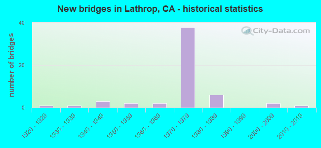
- New bridges - historical statistics
- 11920-1929
- 11930-1939
- 31940-1949
- 21950-1959
- 21960-1969
- 381970-1979
- 61980-1989
- 22000-2009
- 12010-2019

- Reconstructed bridges - Historical Statistics
- 21960-1969
- 01970-1979
- 01980-1989
- 01990-1999
- 22000-2009
- 42010-2019


- Bridge Condition - Deck
- 34.1%Good
- 14.6%Satisfactory
- 29.3%Fair
- 22.0%Poor

- Bridge Condition - Superstructure
- 56.1%Good
- 2.4%Satisfactory
- 41.5%Fair

- Bridge Condition - Substructure
- 82.9%Good
- 2.4%Satisfactory
- 14.6%Fair

- Bridge Condition - Channel
- 14.3%Excellent
- 42.9%Very good
- 28.6%Good
- 14.3%Satisfactory
Find on map >> Show street view
Structure Number: 29 0016F, Location: 10-SJ-005-R14.16 (Lat: 37.785053, Lng: -121.307372), Route carried "on" structure: Ramp State highway 5, Year Built: 1947, Status: Open, Structure Length: 17.77m (58.30ft), Average Daily Traffic: 37,500 (year 2009), Truck Traffic: 9%, Average Future Daily Traffic: 46,575 (year 2039), Design Load: H 20, Features Intersected: SAN JOAQUIN RIVER 03
Minimum Vertical Clearance: 4.98m (16.34ft), Kilometerpoint: 14.160, Lanes on structure: 2, Owner: State Highway Agency, Approaching Roadway Width: 11.9m (39.0ft), Navigation Control: Yes ( Vertical Clearance: 6.7m (22.0ft), Horizontal Clearance: 33.5m (109.9ft)), Material/Design: Steel, Design/Construction: Movable - Bascule, Number Of Spans In Main Unit: 1, Number Of Approach Spans: 4, Length of Maximum Span: 39.6m (129.9ft), Curb or Sidewalk Widths: Left: 0.6m (2.0ft), Right: 0.6m (2.0ft), Curb-To-Curb Width: 8.2m (26.9ft), Out-to-Out Width: 9.6m (31.5ft)
Condition: Deck: Fair, Superstructure: Good, Substructure: Fair, Channel: Very good, Operating Rating: 48.9 metric tons, Method Used To Determine Operating Rating: Load Factor (LF), Inventory Rating: 29.2 metric tons, Method Used To Determine Inventory Rating: Load Factor (LF), Structural Evaluation: Somewhat better than minimum adequacy, Deck Geometry: High priority of corrective action, Waterway Adequacy: Equal to present desirable criteria, Approach Roadway Alignment: Equal to present desirable criteria, Designated Inspection Frequency: Every 24 months, Critical Feature Inspection Frequency: Every 24 months, Underwater Inspection Frequency: Every 60 months, Inspection Date: May 2021, Critical Feature Inspection Date: April 2021, Underwater Inspection Date: August 2019, Deck Structure Type: Concrete Cast-file-Place
Find on map >> Show street view
Structure Number: 29 0029L, Location: 10-SJ-005-R13.87 (Lat: 37.779342, Lng: -121.315231), Route carried "on" structure: Interstate 5, Year Built: 1971, Status: Open, Structure Length: 8.69m (28.51ft), Average Daily Traffic: 80,000 (year 2012), Truck Traffic: 26%, Average Future Daily Traffic: 128,352 (year 2043), Design Load: HS 20, Features Intersected: PARADISE CUT UC
Minimum Vertical Clearance: 30+ m (98+ ft), Kilometerpoint: 13.870, Lanes on structure: 5, Lanes under structure: 2, Base Highway Network: Yes (, Subroute: 1), Owner: State Highway Agency, Approaching Roadway Width: 23.8m (78.1ft), Material/Design: Concrete continuous, Design/Construction: Box Beam or Girders - Multiple, Number Of Spans In Main Unit: 4, Length of Maximum Span: 22.9m (75.1ft), Curb-To-Curb Width: 23.8m (78.1ft), Out-to-Out Width: 24.4m (80.1ft)
Condition: Deck: Fair, Superstructure: Fair, Substructure: Good, Operating Rating: 63.5 metric tons, Method Used To Determine Operating Rating: Load and Resistance Factor Rating (LRFR) rating reported by rating factor(RF) method using HL-93 loadings, Inventory Rating: 48.9 metric tons, Method Used To Determine Inventory Rating: Load and Resistance Factor Rating (LRFR) rating reported by rating factor(RF) method using HL-93 loadings, Structural Evaluation: Somewhat better than minimum adequacy, Deck Geometry: Equal to present minimum criteria, Underclear: Meets minimum limits, Approach Roadway Alignment: Equal to present desirable criteria, Designated Inspection Frequency: Every 24 months, Inspection Date: October 2021, Deck Structure Type: Concrete Cast-file-Place
Find on map >> Show street view
Structure Number: 29 0029R, Location: 10-SJ-005-R13.87 (Lat: 37.779094, Lng: -121.314944), Route carried "on" structure: Interstate 5, Year Built: 1971, Status: Open, Structure Length: 8.69m (28.51ft), Average Daily Traffic: 80,000 (year 2010), Truck Traffic: 26%, Average Future Daily Traffic: 128,352 (year 2043), Design Load: HS 20, Features Intersected: PARADISE CUT UC
Minimum Vertical Clearance: 30+ m (98+ ft), Kilometerpoint: 13.870, Lanes on structure: 5, Lanes under structure: 2, Base Highway Network: Yes (, Subroute: 1), Owner: State Highway Agency, Approaching Roadway Width: 23.8m (78.1ft), Material/Design: Concrete continuous, Design/Construction: Box Beam or Girders - Multiple, Number Of Spans In Main Unit: 4, Length of Maximum Span: 22.9m (75.1ft), Curb-To-Curb Width: 23.8m (78.1ft), Out-to-Out Width: 24.4m (80.1ft)
Condition: Deck: Poor, Superstructure: Fair, Substructure: Good, Operating Rating: 63.5 metric tons, Method Used To Determine Operating Rating: Load and Resistance Factor Rating (LRFR) rating reported by rating factor(RF) method using HL-93 loadings, Inventory Rating: 48.9 metric tons, Method Used To Determine Inventory Rating: Load and Resistance Factor Rating (LRFR) rating reported by rating factor(RF) method using HL-93 loadings, Structural Evaluation: Somewhat better than minimum adequacy, Deck Geometry: Equal to present minimum criteria, Underclear: Meets minimum limits, Approach Roadway Alignment: Equal to present desirable criteria, Designated Inspection Frequency: Every 24 months, Inspection Date: October 2021, Deck Structure Type: Concrete Cast-file-Place
Find on map >> Show street view
Structure Number: 29 0032L, Location: 10-SJ-005-R12.99 (Lat: 37.770739, Lng: -121.327003), Route carried "on" structure: Interstate 5, Year Built: 1947, Year Reconstructed: 1969, Status: Open, Structure Length: 15.45m (50.69ft), Average Daily Traffic: 143,000 (year 2015), Truck Traffic: 16%, Average Future Daily Traffic: 279,893 (year 2043), Design Load: HS 20, Features Intersected: PARADISE CUT
Minimum Vertical Clearance: 30+ m (98+ ft), Kilometerpoint: 12.990, Lanes on structure: 5, Base Highway Network: Yes (, Subroute: 1), Owner: State Highway Agency, Approaching Roadway Width: 23.5m (77.1ft), Skew: 2 degrees, Material/Design: Steel, Design/Construction: Stringer/Multi-beam, Number Of Spans In Main Unit: 11, Length of Maximum Span: 13.4m (44.0ft), Curb-To-Curb Width: 23.8m (78.1ft), Out-to-Out Width: 24.4m (80.1ft)
Condition: Deck: Fair, Superstructure: Good, Substructure: Good, Channel: Very good, Operating Rating: 52.2 metric tons, Method Used To Determine Operating Rating: Load Factor (LF), Inventory Rating: 31.1 metric tons, Method Used To Determine Inventory Rating: Load Factor (LF), Structural Evaluation: Better than present minimum criteria, Deck Geometry: Equal to present minimum criteria, Waterway Adequacy: Equal to present desirable criteria, Approach Roadway Alignment: Equal to present desirable criteria, Designated Inspection Frequency: Every 24 months, Inspection Date: October 2021, Deck Structure Type: Concrete Cast-file-Place, Wearing Surface/Protective System: Wearing Surface: Bituminous
Find on map >> Show street view
Structure Number: 29 0032R, Location: 10-SJ-005-R13.01 (Lat: 37.770672, Lng: -121.326533), Route carried "on" structure: Interstate 5, Year Built: 1969, Status: Open, Structure Length: 13.96m (45.80ft), Average Daily Traffic: 71,500 (year 2010), Truck Traffic: 17%, Average Future Daily Traffic: 143,722 (year 2043), Design Load: HS 20, Features Intersected: PARADISE CUT
Minimum Vertical Clearance: 30+ m (98+ ft), Kilometerpoint: 13.010, Lanes on structure: 3, Base Highway Network: Yes (, Subroute: 1), Owner: State Highway Agency, Approaching Roadway Width: 15.5m (50.9ft), Skew: 2 degrees, Material/Design: Concrete continuous, Design/Construction: Tee Beam, Number Of Spans In Main Unit: 11, Length of Maximum Span: 13.4m (44.0ft), Curb-To-Curb Width: 15.5m (50.9ft), Out-to-Out Width: 16.2m (53.1ft)
Condition: Deck: Poor, Superstructure: Good, Substructure: Good, Channel: Good, Operating Rating: 37.6 metric tons, Method Used To Determine Operating Rating: Load and Resistance Factor Rating (LRFR) rating reported by rating factor(RF) method using HL-93 loadings, Inventory Rating: 28.8 metric tons, Method Used To Determine Inventory Rating: Load and Resistance Factor Rating (LRFR) rating reported by rating factor(RF) method using HL-93 loadings, Structural Evaluation: Better than present minimum criteria, Deck Geometry: Somewhat better than minimum adequacy, Waterway Adequacy: Equal to present desirable criteria, Approach Roadway Alignment: Equal to present desirable criteria, Length Of Structure Improvement: 13.96m (45.80ft), Designated Inspection Frequency: Every 24 months, Inspection Date: October 2021, Bridge Improvement Cost: $2,262,000, Roadway Improvement Cost: $452,000, Total Project Cost: $3,800,000 ( Estimate for 2020), Deck Structure Type: Concrete Cast-file-Place
Find on map >> Show street view
Structure Number: 29 0054L, Location: 10-SJ-005-R16.47 (Lat: 37.811636, Lng: -121.295764), Route carried "on" structure: Interstate 5, Year Built: 1971, Status: Open, Structure Length: 3.93m (12.89ft), Average Daily Traffic: 84,500 (year 2009), Truck Traffic: 20%, Average Future Daily Traffic: 171,518 (year 2043), Design Load: HS 20, Features Intersected: LOUISE AVE
Minimum Vertical Clearance: 30+ m (98+ ft), Kilometerpoint: 16.470, Lanes on structure: 3, Lanes under structure: 4, Base Highway Network: Yes (, Subroute: 1), Owner: State Highway Agency, Approaching Roadway Width: 15.5m (50.9ft), Skew: 1 degrees, Material/Design: Prestressed concrete, Design/Construction: Box Beam or Girders - Multiple, Number Of Spans In Main Unit: 1, Length of Maximum Span: 38.9m (127.6ft), Curb-To-Curb Width: 15.5m (50.9ft), Out-to-Out Width: 16.1m (52.8ft)
Condition: Deck: Good, Superstructure: Fair, Substructure: Good, Operating Rating: 56.1 metric tons, Method Used To Determine Operating Rating: Load and Resistance Factor Rating (LRFR) rating reported by rating factor(RF) method using HL-93 loadings, Inventory Rating: 36.6 metric tons, Method Used To Determine Inventory Rating: Load and Resistance Factor Rating (LRFR) rating reported by rating factor(RF) method using HL-93 loadings, Structural Evaluation: Somewhat better than minimum adequacy, Deck Geometry: Somewhat better than minimum adequacy, Underclear: Better than present minimum criteria, Approach Roadway Alignment: Equal to present desirable criteria, Designated Inspection Frequency: Every 24 months, Inspection Date: October 2021, Deck Structure Type: Concrete Cast-file-Place, Wearing Surface/Protective System: Wearing Surface: Epoxy Overlay
Find on map >> Show street view
Structure Number: 29 0054R, Location: 10-SJ-005-R16.47 (Lat: 37.811639, Lng: -121.295403), Route carried "on" structure: Interstate 5, Year Built: 1971, Status: Open, Structure Length: 3.93m (12.89ft), Average Daily Traffic: 42,250 (year 2009), Truck Traffic: 26%, Average Future Daily Traffic: 86,617 (year 2043), Design Load: HS 20, Features Intersected: LOUISE AVE
Minimum Vertical Clearance: 30+ m (98+ ft), Kilometerpoint: 16.470, Lanes on structure: 3, Lanes under structure: 4, Base Highway Network: Yes (, Subroute: 1), Owner: State Highway Agency, Approaching Roadway Width: 15.5m (50.9ft), Skew: 1 degrees, Material/Design: Prestressed concrete, Design/Construction: Box Beam or Girders - Multiple, Number Of Spans In Main Unit: 1, Length of Maximum Span: 38.9m (127.6ft), Curb-To-Curb Width: 15.5m (50.9ft), Out-to-Out Width: 16.1m (52.8ft)
Condition: Deck: Good, Superstructure: Fair, Substructure: Good, Operating Rating: 56.4 metric tons, Method Used To Determine Operating Rating: Load and Resistance Factor Rating (LRFR) rating reported by rating factor(RF) method using HL-93 loadings, Inventory Rating: 36.6 metric tons, Method Used To Determine Inventory Rating: Load and Resistance Factor Rating (LRFR) rating reported by rating factor(RF) method using HL-93 loadings, Structural Evaluation: Somewhat better than minimum adequacy, Deck Geometry: Somewhat better than minimum adequacy, Underclear: Superior to present desirable criteria, Approach Roadway Alignment: Equal to present desirable criteria, Designated Inspection Frequency: Every 24 months, Inspection Date: October 2021, Deck Structure Type: Concrete Cast-file-Place, Wearing Surface/Protective System: Wearing Surface: Epoxy Overlay
Find on map >> Show street view
Structure Number: 29 0179L, Location: 10-SJ-205-R11.60 (Lat: 37.765328, Lng: -121.351400), Route carried "on" structure: Interstate 205, Year Built: 1970, Year Reconstructed: 2010, Status: Open, Structure Length: 7.39m (24.25ft), Average Daily Traffic: 48,500 (year 2009), Truck Traffic: 11%, Average Future Daily Traffic: 62,130 (year 2040), Design Load: HS 20+Mod, Features Intersected: UP RR
Minimum Vertical Clearance: 30+ m (98+ ft), Kilometerpoint: 11.600, Lanes on structure: 3, Base Highway Network: Yes (Inventory Route: 2, Subroute: 1), Owner: State Highway Agency, Approaching Roadway Width: 17.0m (55.8ft), Skew: 5 degrees, Material/Design: Prestressed concrete continuous, Design/Construction: Stringer/Multi-beam, Number Of Spans In Main Unit: 1, Number Of Approach Spans: 2, Length of Maximum Span: 28.0m (91.9ft), Curb-To-Curb Width: 17.0m (55.8ft), Out-to-Out Width: 17.7m (58.1ft)
Condition: Deck: Satisfactory, Superstructure: Good, Substructure: Good, Operating Rating: 54.1 metric tons, Method Used To Determine Operating Rating: Assigned rating based on Load Factor Design (LFD) reported in metric tons, Inventory Rating: 32.4 metric tons, Method Used To Determine Inventory Rating: Assigned rating based on Load Factor Design (LFD) reported in metric tons, Structural Evaluation: Better than present minimum criteria, Deck Geometry: Equal to present minimum criteria, Underclear: Equal to present minimum criteria, Approach Roadway Alignment: Equal to present desirable criteria, Designated Inspection Frequency: Every 24 months, Inspection Date: April 2020, Deck Structure Type: Concrete Cast-file-Place, Wearing Surface/Protective System: Wearing Surface: Integral Concrete
Find on map >> Show street view
Structure Number: 29 0179R, Location: 10-SJ-205-R11.60 (Lat: 37.765019, Lng: -121.351853), Route carried "on" structure: Interstate 205, Year Built: 1970, Year Reconstructed: 2010, Status: Open, Structure Length: 7.39m (24.25ft), Average Daily Traffic: 48,500 (year 2009), Truck Traffic: 11%, Average Future Daily Traffic: 62,130 (year 2040), Design Load: HS 20+Mod, Features Intersected: UP RR
Minimum Vertical Clearance: 30+ m (98+ ft), Kilometerpoint: 11.600, Lanes on structure: 3, Base Highway Network: Yes (Inventory Route: 2, Subroute: 1), Owner: State Highway Agency, Approaching Roadway Width: 17.0m (55.8ft), Skew: 5 degrees, Material/Design: Prestressed concrete, Design/Construction: Stringer/Multi-beam, Number Of Spans In Main Unit: 1, Number Of Approach Spans: 2, Length of Maximum Span: 28.0m (91.9ft), Curb-To-Curb Width: 17.0m (55.8ft), Out-to-Out Width: 17.7m (58.1ft)
Condition: Deck: Satisfactory, Superstructure: Good, Substructure: Good, Operating Rating: 54.1 metric tons, Method Used To Determine Operating Rating: Assigned rating based on Load Factor Design (LFD) reported in metric tons, Inventory Rating: 32.4 metric tons, Method Used To Determine Inventory Rating: Assigned rating based on Load Factor Design (LFD) reported in metric tons, Structural Evaluation: Better than present minimum criteria, Deck Geometry: Equal to present minimum criteria, Underclear: Equal to present minimum criteria, Approach Roadway Alignment: Equal to present desirable criteria, Designated Inspection Frequency: Every 24 months, Inspection Date: April 2020, Deck Structure Type: Concrete Cast-file-Place, Wearing Surface/Protective System: Wearing Surface: Integral Concrete
Find on map >> Show street view
Structure Number: 29 0180R, Location: 10-SJ-205-R11.72 (Lat: 37.765267, Lng: -121.349311), Route carried "on" structure: Interstate 205, Year Built: 1970, Year Reconstructed: 2010, Status: Open, Structure Length: 12.32m (40.42ft), Average Daily Traffic: 48,500 (year 2009), Truck Traffic: 11%, Average Future Daily Traffic: 62,130 (year 2040), Design Load: HS 20+Mod, Features Intersected: CANAL ROAD
Minimum Vertical Clearance: 30+ m (98+ ft), Kilometerpoint: 11.720, Lanes on structure: 3, Lanes under structure: 2, Base Highway Network: Yes (Inventory Route: 2, Subroute: 1), Owner: State Highway Agency, Approaching Roadway Width: 17.0m (55.8ft), Skew: 4 degrees, Material/Design: Concrete continuous, Design/Construction: Box Beam or Girders - Multiple, Number Of Spans In Main Unit: 5, Length of Maximum Span: 24.4m (80.1ft), Curb-To-Curb Width: 17.0m (55.8ft), Out-to-Out Width: 17.7m (58.1ft)
Condition: Deck: Satisfactory, Superstructure: Good, Substructure: Good, Channel: Excellent, Operating Rating: 54.1 metric tons, Method Used To Determine Operating Rating: Assigned rating based on Load Factor Design (LFD) reported in metric tons, Inventory Rating: 32.4 metric tons, Method Used To Determine Inventory Rating: Assigned rating based on Load Factor Design (LFD) reported in metric tons, Structural Evaluation: Better than present minimum criteria, Deck Geometry: Equal to present minimum criteria, Underclear: High priority of corrective action, Waterway Adequacy: Superior to present desirable criteria, Approach Roadway Alignment: Equal to present desirable criteria, Designated Inspection Frequency: Every 24 months, Inspection Date: April 2020, Deck Structure Type: Concrete Cast-file-Place, Wearing Surface/Protective System: Wearing Surface: Integral Concrete
Find on map >> Show street view
Structure Number: 29 0211G, Location: 10-SJ-205-R12.64 (Lat: 37.766881, Lng: -121.332794), Route carried "on" structure: Ramp Interstate 205, Year Built: 1970, Year Reconstructed: 2010, Status: Open, Structure Length: 19.00m (62.34ft), Average Daily Traffic: 32,500 (year 1998), Truck Traffic: 2%, Average Future Daily Traffic: 124,811 (year 2042), Design Load: HS 20+Mod, Features Intersected: INTERSTATE 5
Minimum Vertical Clearance: 30+ m (98+ ft), Kilometerpoint: 12.640, Lanes on structure: 3, Lanes under structure: 7, Base Highway Network: Yes (Inventory Route: 2, Subroute: 1), Owner: State Highway Agency, Approaching Roadway Width: 17.0m (55.8ft), Skew: 5 degrees, Material/Design: Steel continuous, Design/Construction: Stringer/Multi-beam, Number Of Spans In Main Unit: 3, Length of Maximum Span: 65.8m (215.9ft), Curb-To-Curb Width: 17.0m (55.8ft), Out-to-Out Width: 17.7m (58.1ft)
Condition: Deck: Poor, Superstructure: Good, Substructure: Good, Operating Rating: 66.1 metric tons, Method Used To Determine Operating Rating: Load Factor (LF), Inventory Rating: 39.5 metric tons, Method Used To Determine Inventory Rating: Load Factor (LF), Structural Evaluation: Better than present minimum criteria, Deck Geometry: Superior to present desirable criteria, Underclear: Somewhat better than minimum adequacy, Approach Roadway Alignment: Equal to present desirable criteria, Length Of Structure Improvement: 18.93m (62.11ft), Designated Inspection Frequency: Every 24 months, Other Special Inspection Frequency: Every 48 months, Inspection Date: April 2020, Other Special Inspection Date: March 2020, Deck Structure Type: Concrete Cast-file-Place
Find on map >> Show street view
Structure Number: 29 0216L, Location: 10-SJ-005-R19.58 (Lat: 37.855381, Lng: -121.282192), Route carried "on" structure: Interstate 5, Year Built: 1971, Status: Open, Structure Length: 4.60m (15.09ft), Average Daily Traffic: 84,500 (year 2015), Truck Traffic: 20%, Average Future Daily Traffic: 173,238 (year 2043), Design Load: HS 20, Features Intersected: ROTH ROAD
Minimum Vertical Clearance: 30+ m (98+ ft), Kilometerpoint: 19.580, Lanes on structure: 3, Lanes under structure: 6, Base Highway Network: Yes (, Subroute: 1), Owner: State Highway Agency, Approaching Roadway Width: 15.5m (50.9ft), Skew: 1 degrees, Material/Design: Concrete continuous, Design/Construction: Box Beam or Girders - Multiple, Number Of Spans In Main Unit: 2, Length of Maximum Span: 22.7m (74.5ft), Curb-To-Curb Width: 15.5m (50.9ft), Out-to-Out Width: 16.2m (53.1ft)
Condition: Deck: Good, Superstructure: Fair, Substructure: Good, Operating Rating: 31.1 metric tons, Method Used To Determine Operating Rating: Load and Resistance Factor Rating (LRFR) rating reported by rating factor(RF) method using HL-93 loadings, Inventory Rating: 24.0 metric tons, Method Used To Determine Inventory Rating: Load and Resistance Factor Rating (LRFR) rating reported by rating factor(RF) method using HL-93 loadings, Structural Evaluation: Somewhat better than minimum adequacy, Deck Geometry: Somewhat better than minimum adequacy, Underclear: Meets minimum limits, Approach Roadway Alignment: Equal to present desirable criteria, Designated Inspection Frequency: Every 24 months, Inspection Date: October 2021, Deck Structure Type: Concrete Cast-file-Place, Wearing Surface/Protective System: Wearing Surface: Integral Concrete
Find on map >> Show street view
Structure Number: 29 0216R, Location: 10-SJ-005-R19.58 (Lat: 37.855378, Lng: -121.281833), Route carried "on" structure: Interstate 5, Year Built: 1971, Status: Open, Structure Length: 4.60m (15.09ft), Average Daily Traffic: 42,250 (year 2009), Truck Traffic: 26%, Average Future Daily Traffic: 86,617 (year 2043), Features Intersected: ROTH ROAD
Minimum Vertical Clearance: 30+ m (98+ ft), Kilometerpoint: 19.580, Lanes on structure: 3, Lanes under structure: 6, Base Highway Network: Yes (, Subroute: 1), Owner: State Highway Agency, Approaching Roadway Width: 15.5m (50.9ft), Skew: 1 degrees, Material/Design: Concrete continuous, Design/Construction: Box Beam or Girders - Multiple, Number Of Spans In Main Unit: 2, Length of Maximum Span: 22.9m (75.1ft), Curb-To-Curb Width: 15.5m (50.9ft), Out-to-Out Width: 16.1m (52.8ft)
Condition: Deck: Fair, Superstructure: Fair, Substructure: Good, Operating Rating: 45.4 metric tons, Method Used To Determine Operating Rating: Load and Resistance Factor Rating (LRFR) rating reported by rating factor(RF) method using HL-93 loadings, Inventory Rating: 32.4 metric tons, Method Used To Determine Inventory Rating: Load and Resistance Factor Rating (LRFR) rating reported by rating factor(RF) method using HL-93 loadings, Structural Evaluation: Somewhat better than minimum adequacy, Deck Geometry: Somewhat better than minimum adequacy, Underclear: Equal to present minimum criteria, Approach Roadway Alignment: Equal to present desirable criteria, Designated Inspection Frequency: Every 24 months, Inspection Date: October 2021, Deck Structure Type: Concrete Cast-file-Place, Wearing Surface/Protective System: Wearing Surface: Epoxy Overlay
Find on map >> Show street view
Structure Number: 29 0251L, Location: 10-SJ-005-R14.80 (Lat: 37.788250, Lng: -121.302506), Route carried "on" structure: Interstate 5, Year Built: 1971, Status: Open, Structure Length: 15.42m (50.59ft), Average Daily Traffic: 80,000 (year 2015), Truck Traffic: 26%, Average Future Daily Traffic: 127,078 (year 2043), Design Load: HS 20+Mod, Features Intersected: W120-S5 CONN RMP & UP RR
Minimum Vertical Clearance: 30+ m (98+ ft), Kilometerpoint: 14.800, Lanes on structure: 3, Lanes under structure: 2, Base Highway Network: Yes (, Subroute: 1), Owner: State Highway Agency, Approaching Roadway Width: 15.5m (50.9ft), Skew: 4 degrees, Material/Design: Concrete continuous, Design/Construction: Box Beam or Girders - Multiple, Number Of Spans In Main Unit: 5, Length of Maximum Span: 39.6m (129.9ft), Curb-To-Curb Width: 15.5m (50.9ft), Out-to-Out Width: 16.1m (52.8ft)
Condition: Deck: Good, Superstructure: Good, Substructure: Good, Operating Rating: 89.4 metric tons, Method Used To Determine Operating Rating: Load Factor (LF), Inventory Rating: 53.8 metric tons, Method Used To Determine Inventory Rating: Load Factor (LF), Structural Evaluation: Better than present minimum criteria, Deck Geometry: Somewhat better than minimum adequacy, Underclear: Equal to present minimum criteria, Approach Roadway Alignment: Equal to present desirable criteria, Designated Inspection Frequency: Every 24 months, Inspection Date: October 2021, Deck Structure Type: Concrete Cast-file-Place, Wearing Surface/Protective System: Wearing Surface: Epoxy Overlay
Find on map >> Show street view
Structure Number: 29 0251R, Location: 10-SJ-005-R14.82 (Lat: 37.788514, Lng: -121.301892), Route carried "on" structure: Interstate 5, Year Built: 1971, Year Reconstructed: 2008, Status: Open, Structure Length: 14.17m (46.49ft), Average Daily Traffic: 71,500 (year 2010), Truck Traffic: 17%, Average Future Daily Traffic: 143,722 (year 2043), Design Load: HS 20+Mod, Features Intersected: W120-S5 CONN RMP & UP RR
Minimum Vertical Clearance: 30+ m (98+ ft), Kilometerpoint: 14.820, Lanes on structure: 4, Lanes under structure: 2, Base Highway Network: Yes (, Subroute: 1), Owner: State Highway Agency, Approaching Roadway Width: 20.5m (67.3ft), Skew: 4 degrees, Material/Design: Concrete continuous, Design/Construction: Box Beam or Girders - Multiple, Number Of Spans In Main Unit: 5, Length of Maximum Span: 36.0m (118.1ft), Curb-To-Curb Width: 20.5m (67.3ft), Out-to-Out Width: 21.4m (70.2ft)
Condition: Deck: Good, Superstructure: Good, Substructure: Good, Operating Rating: 54.1 metric tons, Method Used To Determine Operating Rating: Assigned rating based on Load Factor Design (LFD) reported in metric tons, Inventory Rating: 32.4 metric tons, Method Used To Determine Inventory Rating: Assigned rating based on Load Factor Design (LFD) reported in metric tons, Structural Evaluation: Better than present minimum criteria, Deck Geometry: Equal to present minimum criteria, Underclear: Equal to present minimum criteria, Approach Roadway Alignment: Equal to present desirable criteria, Designated Inspection Frequency: Every 24 months, Inspection Date: October 2021, Deck Structure Type: Concrete Cast-file-Place, Wearing Surface/Protective System: Wearing Surface: Epoxy Overlay
Find on map >> Show street view
Structure Number: 29 0252L, Location: 10-SJ-005-R14.46 (Lat: 37.784900, Lng: -121.306997), Route carried "on" structure: Interstate 5, Year Built: 1972, Status: Open, Structure Length: 23.53m (77.20ft), Average Daily Traffic: 80,000 (year 2013), Truck Traffic: 26%, Average Future Daily Traffic: 126,234 (year 2043), Design Load: HS 20, Features Intersected: SAN JOAQUIN RIVER
Minimum Vertical Clearance: 30+ m (98+ ft), Kilometerpoint: 14.460, Lanes on structure: 3, Lanes under structure: 1, Base Highway Network: Yes (, Subroute: 1), Owner: State Highway Agency, Approaching Roadway Width: 16.5m (54.1ft), Material/Design: Concrete continuous, Design/Construction: Box Beam or Girders - Multiple, Number Of Spans In Main Unit: 6, Length of Maximum Span: 44.2m (145.0ft), Curb-To-Curb Width: 15.5m (50.9ft), Out-to-Out Width: 16.1m (52.8ft)
Condition: Deck: Satisfactory, Superstructure: Fair, Substructure: Good, Channel: Very good, Operating Rating: 45.0 metric tons, Method Used To Determine Operating Rating: Load and Resistance Factor Rating (LRFR) rating reported by rating factor(RF) method using HL-93 loadings, Inventory Rating: 34.7 metric tons, Method Used To Determine Inventory Rating: Load and Resistance Factor Rating (LRFR) rating reported by rating factor(RF) method using HL-93 loadings, Structural Evaluation: Somewhat better than minimum adequacy, Deck Geometry: Somewhat better than minimum adequacy, Underclear: Superior to present desirable criteria, Waterway Adequacy: Equal to present desirable criteria, Approach Roadway Alignment: Equal to present desirable criteria, Designated Inspection Frequency: Every 24 months, Underwater Inspection Frequency: Every 60 months, Inspection Date: October 2021, Underwater Inspection Date: August 2019, Deck Structure Type: Concrete Cast-file-Place, Wearing Surface/Protective System: Wearing Surface: Epoxy Overlay
Find on map >> Show street view
Structure Number: 29 0252R, Location: 10-SJ-005-R14.46 (Lat: 37.784683, Lng: -121.306706), Route carried "on" structure: Interstate 5, Year Built: 1971, Year Reconstructed: 2008, Status: Open, Structure Length: 21.12m (69.29ft), Average Daily Traffic: 80,000 (year 2010), Truck Traffic: 26%, Average Future Daily Traffic: 128,352 (year 2043), Design Load: HS 20, Features Intersected: SAN JOAQUIN RIVER 05
Minimum Vertical Clearance: 30+ m (98+ ft), Kilometerpoint: 14.460, Lanes on structure: 5, Lanes under structure: 1, Base Highway Network: Yes (, Subroute: 1), Owner: State Highway Agency, Approaching Roadway Width: 25.7m (84.3ft), Material/Design: Concrete continuous, Design/Construction: Box Beam or Girders - Multiple, Number Of Spans In Main Unit: 5, Length of Maximum Span: 44.2m (145.0ft), Curb-To-Curb Width: 24.8m (81.4ft), Out-to-Out Width: 25.7m (84.3ft)
Condition: Deck: Satisfactory, Superstructure: Fair, Substructure: Good, Channel: Very good, Operating Rating: 54.1 metric tons, Method Used To Determine Operating Rating: Field evaluation and documented engineering judgment, Inventory Rating: 32.4 metric tons, Method Used To Determine Inventory Rating: Field evaluation and documented engineering judgment, Structural Evaluation: Somewhat better than minimum adequacy, Deck Geometry: Better than present minimum criteria, Waterway Adequacy: Superior to present desirable criteria, Approach Roadway Alignment: Equal to present desirable criteria, Designated Inspection Frequency: Every 24 months, Underwater Inspection Frequency: Every 60 months, Inspection Date: October 2021, Underwater Inspection Date: August 2019, Deck Structure Type: Concrete Cast-file-Place, Wearing Surface/Protective System: Wearing Surface: Integral Concrete
Find on map >> Show street view
Structure Number: 29 0253L, Location: 10-SJ-005-R17.52 (Lat: 37.826161, Lng: -121.290247), Route carried "on" structure: Interstate 5, Year Built: 1971, Status: Open, Structure Length: 4.33m (14.21ft), Average Daily Traffic: 50,000 (year 2015), Truck Traffic: 25%, Average Future Daily Traffic: 82,768 (year 2043), Design Load: HS 20, Features Intersected: LATHROP RD
Minimum Vertical Clearance: 30+ m (98+ ft), Kilometerpoint: 17.520, Lanes on structure: 3, Lanes under structure: 3, Base Highway Network: Yes (, Subroute: 1), Owner: State Highway Agency, Approaching Roadway Width: 15.5m (50.9ft), Skew: 1 degrees, Material/Design: Prestressed concrete, Design/Construction: Box Beam or Girders - Multiple, Number Of Spans In Main Unit: 1, Length of Maximum Span: 42.8m (140.4ft), Curb-To-Curb Width: 15.5m (50.9ft), Out-to-Out Width: 16.1m (52.8ft)
Condition: Deck: Fair, Superstructure: Fair, Substructure: Good, Operating Rating: 57.0 metric tons, Method Used To Determine Operating Rating: Load and Resistance Factor Rating (LRFR) rating reported by rating factor(RF) method using HL-93 loadings, Inventory Rating: 35.6 metric tons, Method Used To Determine Inventory Rating: Load and Resistance Factor Rating (LRFR) rating reported by rating factor(RF) method using HL-93 loadings, Structural Evaluation: Somewhat better than minimum adequacy, Deck Geometry: Somewhat better than minimum adequacy, Underclear: Superior to present desirable criteria, Approach Roadway Alignment: Equal to present desirable criteria, Designated Inspection Frequency: Every 24 months, Inspection Date: October 2021, Deck Structure Type: Concrete Cast-file-Place, Wearing Surface/Protective System: Wearing Surface: Epoxy Overlay
Find on map >> Show street view
Structure Number: 29 0253R, Location: 10-SJ-005-R17.52 (Lat: 37.826164, Lng: -121.289878), Route carried "on" structure: Interstate 5, Year Built: 1971, Status: Open, Structure Length: 4.33m (14.21ft), Average Daily Traffic: 42,250 (year 2009), Truck Traffic: 26%, Average Future Daily Traffic: 86,617 (year 2043), Design Load: HS 20, Features Intersected: LATHROP RD
Minimum Vertical Clearance: 30+ m (98+ ft), Kilometerpoint: 17.520, Lanes on structure: 3, Lanes under structure: 5, Base Highway Network: Yes (, Subroute: 1), Owner: State Highway Agency, Approaching Roadway Width: 15.5m (50.9ft), Skew: 1 degrees, Material/Design: Prestressed concrete, Design/Construction: Box Beam or Girders - Multiple, Number Of Spans In Main Unit: 1, Length of Maximum Span: 42.8m (140.4ft), Curb-To-Curb Width: 15.5m (50.9ft), Out-to-Out Width: 16.1m (52.8ft)
Condition: Deck: Satisfactory, Superstructure: Fair, Substructure: Good, Operating Rating: 57.7 metric tons, Method Used To Determine Operating Rating: Load and Resistance Factor Rating (LRFR) rating reported by rating factor(RF) method using HL-93 loadings, Inventory Rating: 36.0 metric tons, Method Used To Determine Inventory Rating: Load and Resistance Factor Rating (LRFR) rating reported by rating factor(RF) method using HL-93 loadings, Structural Evaluation: Somewhat better than minimum adequacy, Deck Geometry: Somewhat better than minimum adequacy, Underclear: Better than present minimum criteria, Approach Roadway Alignment: Equal to present desirable criteria, Designated Inspection Frequency: Every 24 months, Inspection Date: October 2021, Deck Structure Type: Concrete Cast-file-Place, Wearing Surface/Protective System: Wearing Surface: Epoxy Overlay
Find on map >> Show street view
Structure Number: 29 0262L, Location: 10-SJ-005-10.65 (Lat: 37.742231, Lng: -121.343783), Route carried "on" structure: Interstate 5, Year Built: 1971, Status: Open, Structure Length: 6.31m (20.70ft), Average Daily Traffic: 11,000 (year 2009), Truck Traffic: 35%, Average Future Daily Traffic: 26,385 (year 2042), Design Load: HS 20+Mod, Features Intersected: UP RAILROAD & FARM ROADS
Minimum Vertical Clearance: 30+ m (98+ ft), Kilometerpoint: 10.650, Lanes on structure: 2, Lanes under structure: 1, Base Highway Network: Yes (, Subroute: 1), Owner: State Highway Agency, Approaching Roadway Width: 12.8m (42.0ft), Skew: 4 degrees, Material/Design: Prestressed concrete continuous, Design/Construction: Stringer/Multi-beam, Number Of Spans In Main Unit: 3, Length of Maximum Span: 26.5m (86.9ft), Curb-To-Curb Width: 11.8m (38.7ft), Out-to-Out Width: 12.8m (42.0ft)
Condition: Deck: Poor, Superstructure: Good, Substructure: Good, Operating Rating: 42.4 metric tons, Method Used To Determine Operating Rating: Load and Resistance Factor Rating (LRFR) rating reported by rating factor(RF) method using HL-93 loadings, Inventory Rating: 24.6 metric tons, Method Used To Determine Inventory Rating: Load and Resistance Factor Rating (LRFR) rating reported by rating factor(RF) method using HL-93 loadings, Structural Evaluation: Equal to present minimum criteria, Deck Geometry: Equal to present minimum criteria, Underclear: High priority of corrective action, Approach Roadway Alignment: Equal to present desirable criteria, Length Of Structure Improvement: 6.31m (20.70ft), Designated Inspection Frequency: Every 24 months, Inspection Date: October 2020, Bridge Improvement Cost: $750,000, Roadway Improvement Cost: $150,000, Total Project Cost: $1,260,000 ( Estimate for 2017), Deck Structure Type: Concrete Cast-file-Place
Find on map >> Show street view
Structure Number: 29 0262R, Location: 10-SJ-005-10.65 (Lat: 37.742506, Lng: -121.343392), Route carried "on" structure: Interstate 5, Year Built: 1971, Status: Open, Structure Length: 6.31m (20.70ft), Average Daily Traffic: 11,000 (year 2016), Truck Traffic: 35%, Average Future Daily Traffic: 25,777 (year 2039), Design Load: HS 20+Mod, Features Intersected: UP RAILROAD & FARM ROADS
Minimum Vertical Clearance: 30+ m (98+ ft), Kilometerpoint: 10.650, Lanes on structure: 2, Lanes under structure: 1, Base Highway Network: Yes (, Subroute: 1), Owner: State Highway Agency, Approaching Roadway Width: 11.9m (39.0ft), Skew: 4 degrees, Material/Design: Prestressed concrete continuous, Design/Construction: Stringer/Multi-beam, Number Of Spans In Main Unit: 3, Length of Maximum Span: 26.5m (86.9ft), Curb-To-Curb Width: 11.8m (38.7ft), Out-to-Out Width: 12.8m (42.0ft)
Condition: Deck: Poor, Superstructure: Good, Substructure: Good, Operating Rating: 42.4 metric tons, Method Used To Determine Operating Rating: Load and Resistance Factor Rating (LRFR) rating reported by rating factor(RF) method using HL-93 loadings, Inventory Rating: 24.6 metric tons, Method Used To Determine Inventory Rating: Load and Resistance Factor Rating (LRFR) rating reported by rating factor(RF) method using HL-93 loadings, Structural Evaluation: Equal to present minimum criteria, Deck Geometry: Equal to present minimum criteria, Underclear: High priority of corrective action, Approach Roadway Alignment: Equal to present desirable criteria, Length Of Structure Improvement: 6.31m (20.70ft), Designated Inspection Frequency: Every 24 months, Inspection Date: October 2020, Bridge Improvement Cost: $750,000, Roadway Improvement Cost: $150,000, Total Project Cost: $1,260,000 ( Estimate for 2017), Deck Structure Type: Concrete Cast-file-Place
Find on map >> Show street view
Structure Number: 29 0263, Location: 10-SJ-005-11.06 (Lat: 37.748400, Lng: -121.344056), Route carried "on" structure: County highway , Year Built: 1971, Status: Open, Structure Length: 8.44m (27.69ft), Average Daily Traffic: 1,980 (year 2016), Truck Traffic: 10%, Average Future Daily Traffic: 4,245 (year 2038), Design Load: HS 20+Mod, Features Intersected: INTERSTATE ROUTE 5, Facility Carried by Structure: KASSON ROAD
Minimum Vertical Clearance: 30+ m (98+ ft), Kilometerpoint: 0.000, Lanes on structure: 2, Lanes under structure: 5, Owner: State Highway Agency, Approaching Roadway Width: 12.2m (40.0ft), Skew: 3 degrees, Material/Design: Prestressed concrete continuous, Design/Construction: Box Beam or Girders - Multiple, Number Of Spans In Main Unit: 2, Length of Maximum Span: 44.8m (147.0ft), Curb-To-Curb Width: 12.2m (40.0ft), Out-to-Out Width: 12.8m (42.0ft)
Condition: Deck: Poor, Superstructure: Good, Substructure: Good, Operating Rating: 59.9 metric tons, Method Used To Determine Operating Rating: Load and Resistance Factor Rating (LRFR) rating reported by rating factor(RF) method using HL-93 loadings, Inventory Rating: 40.8 metric tons, Method Used To Determine Inventory Rating: Load and Resistance Factor Rating (LRFR) rating reported by rating factor(RF) method using HL-93 loadings, Structural Evaluation: Better than present minimum criteria, Deck Geometry: Better than present minimum criteria, Underclear: High priority of corrective action, Approach Roadway Alignment: Equal to present desirable criteria, Designated Inspection Frequency: Every 24 months, Inspection Date: October 2020, Deck Structure Type: Concrete Cast-file-Place
Find on map >> Show street view
Structure Number: 29 0264, Location: 10-SJ-005-R11.79 (Lat: 37.758394, Lng: -121.343164), Route carried "on" structure: County highway Y332, Year Built: 1971, Status: Open, Structure Length: 10.97m (35.99ft), Average Daily Traffic: 20,967 (year 2010), Truck Traffic: 19%, Average Future Daily Traffic: 35,478 (year 2042), Design Load: HS 20+Mod, Features Intersected: INTERSTATE ROUTE 5, Facility Carried by Structure: 11 ST-OLD RTE 205
Minimum Vertical Clearance: 30+ m (98+ ft), Kilometerpoint: 0.000, Lanes on structure: 2, Lanes under structure: 4, Base Highway Network: Yes, Owner: State Highway Agency, Approaching Roadway Width: 11.3m (37.1ft), Skew: 5 degrees, Material/Design: Prestressed concrete continuous, Design/Construction: Box Beam or Girders - Multiple, Number Of Spans In Main Unit: 2, Length of Maximum Span: 57.0m (187.0ft), Curb-To-Curb Width: 11.3m (37.1ft), Out-to-Out Width: 11.9m (39.0ft)
Condition: Deck: Good, Superstructure: Good, Substructure: Good, Operating Rating: 99.8 metric tons, Method Used To Determine Operating Rating: Load Factor (LF), Inventory Rating: 32.4 metric tons, Method Used To Determine Inventory Rating: Load Factor (LF), Structural Evaluation: Better than present minimum criteria, Deck Geometry: Meets minimum limits, Underclear: Equal to present minimum criteria, Approach Roadway Alignment: Equal to present desirable criteria, Designated Inspection Frequency: Every 24 months, Inspection Date: October 2020, Deck Structure Type: Concrete Cast-file-Place
Find on map >> Show street view
Structure Number: 29 0265L, Location: 10-SJ-005-R12.39 (Lat: 37.764869, Lng: -121.335139), Route carried "on" structure: Interstate 5, Year Built: 1971, Status: Open, Structure Length: 5.94m (19.49ft), Average Daily Traffic: 23,750 (year 2010), Truck Traffic: 31%, Average Future Daily Traffic: 39,156 (year 2043), Design Load: HS 20, Features Intersected: TOM PAINE SLOUGH
Minimum Vertical Clearance: 30+ m (98+ ft), Kilometerpoint: 12.390, Lanes on structure: 3, Base Highway Network: Yes (, Subroute: 1), Owner: State Highway Agency, Approaching Roadway Width: 15.5m (50.9ft), Skew: 3 degrees, Material/Design: Concrete continuous, Design/Construction: Slab, Number Of Spans In Main Unit: 7, Length of Maximum Span: 9.1m (29.9ft), Curb-To-Curb Width: 15.5m (50.9ft), Out-to-Out Width: 16.6m (54.5ft)
Condition: Deck: Fair, Superstructure: Fair, Substructure: Good, Channel: Very good, Operating Rating: 68.4 metric tons, Method Used To Determine Operating Rating: Load Factor (LF), Inventory Rating: 41.1 metric tons, Method Used To Determine Inventory Rating: Load Factor (LF), Structural Evaluation: Somewhat better than minimum adequacy, Deck Geometry: Somewhat better than minimum adequacy, Waterway Adequacy: Equal to present desirable criteria, Approach Roadway Alignment: Equal to present desirable criteria, Designated Inspection Frequency: Every 24 months, Inspection Date: October 2021, Deck Structure Type: Concrete Cast-file-Place
Find on map >> Show street view
Structure Number: 29 0265R, Location: 10-SJ-005-R12.39 (Lat: 37.764753, Lng: -121.334658), Route carried "on" structure: Interstate 5, Year Built: 1971, Status: Open, Structure Length: 5.94m (19.49ft), Average Daily Traffic: 23,750 (year 2010), Truck Traffic: 31%, Average Future Daily Traffic: 39,156 (year 2043), Design Load: HS 20, Features Intersected: TOM PAINE SLOUGH
Minimum Vertical Clearance: 30+ m (98+ ft), Kilometerpoint: 12.390, Lanes on structure: 3, Base Highway Network: Yes (, Subroute: 1), Owner: State Highway Agency, Approaching Roadway Width: 15.6m (51.2ft), Skew: 3 degrees, Material/Design: Concrete continuous, Design/Construction: Slab, Number Of Spans In Main Unit: 7, Length of Maximum Span: 9.1m (29.9ft), Curb-To-Curb Width: 15.6m (51.2ft), Out-to-Out Width: 16.5m (54.1ft)
Condition: Deck: Fair, Superstructure: Fair, Substructure: Good, Channel: Very good, Operating Rating: 68.4 metric tons, Method Used To Determine Operating Rating: Load Factor (LF), Inventory Rating: 41.1 metric tons, Method Used To Determine Inventory Rating: Load Factor (LF), Structural Evaluation: Somewhat better than minimum adequacy, Deck Geometry: Somewhat better than minimum adequacy, Waterway Adequacy: Equal to present desirable criteria, Approach Roadway Alignment: Equal to present desirable criteria, Designated Inspection Frequency: Every 24 months, Inspection Date: October 2021, Deck Structure Type: Concrete Cast-file-Place
Find on map >> Show street view
Structure Number: 29 0271R, Location: 10-SJ-120-R1.33 (Lat: 37.789158, Lng: -121.287511), Route carried "on" structure: State highway 120, Year Built: 1980, Status: Open, Structure Length: 3.63m (11.91ft), Average Daily Traffic: 37,500 (year 2009), Truck Traffic: 19%, Average Future Daily Traffic: 56,675 (year 2041), Design Load: HS 20+Mod, Features Intersected: GUTHMILLER ROAD
Minimum Vertical Clearance: 30+ m (98+ ft), Kilometerpoint: 1.330, Lanes on structure: 2, Lanes under structure: 2, Base Highway Network: Yes (Inventory Route: 1, Subroute: 1), Owner: State Highway Agency, Approaching Roadway Width: 11.9m (39.0ft), Skew: 1 degrees, Material/Design: Prestressed concrete, Design/Construction: Box Beam or Girders - Multiple, Number Of Spans In Main Unit: 1, Length of Maximum Span: 35.9m (117.8ft), Curb-To-Curb Width: 11.7m (38.4ft), Out-to-Out Width: 12.7m (41.7ft)
Condition: Deck: Good, Superstructure: Fair, Substructure: Good, Operating Rating: 54.1 metric tons, Method Used To Determine Operating Rating: Assigned rating based on Load Factor Design (LFD) reported in metric tons, Inventory Rating: 32.4 metric tons, Method Used To Determine Inventory Rating: Assigned rating based on Load Factor Design (LFD) reported in metric tons, Structural Evaluation: Somewhat better than minimum adequacy, Deck Geometry: Better than present minimum criteria, Underclear: Equal to present minimum criteria, Approach Roadway Alignment: Equal to present desirable criteria, Designated Inspection Frequency: Every 24 months, Inspection Date: May 2021, Deck Structure Type: Concrete Cast-file-Place
Find on map >> Show street view
Structure Number: 29 0291F, Location: 10-SJ-120-R0.76 (Lat: 37.789872, Lng: -121.300469), Route carried "on" structure: State highway 120, Year Built: 1980, Status: Open, Structure Length: 26.43m (86.71ft), Average Daily Traffic: 19,750 (year 2015), Truck Traffic: 18%, Average Future Daily Traffic: 26,018 (year 2043), Design Load: HS 20+Mod, Features Intersected: UP RR
Minimum Vertical Clearance: 30+ m (98+ ft), Kilometerpoint: 0.760, Lanes on structure: 1, Base Highway Network: Yes (Inventory Route: 1, Subroute: 1), Owner: State Highway Agency, Approaching Roadway Width: 8.2m (26.9ft), Material/Design: Concrete continuous, Design/Construction: Box Beam or Girders - Multiple, Number Of Spans In Main Unit: 7, Length of Maximum Span: 41.5m (136.2ft), Curb-To-Curb Width: 8.1m (26.6ft), Out-to-Out Width: 9.1m (29.9ft)
Condition: Deck: Poor, Superstructure: Fair, Substructure: Good, Operating Rating: 50.2 metric tons, Method Used To Determine Operating Rating: Load and Resistance Factor Rating (LRFR) rating reported by rating factor(RF) method using HL-93 loadings, Inventory Rating: 38.6 metric tons, Method Used To Determine Inventory Rating: Load and Resistance Factor Rating (LRFR) rating reported by rating factor(RF) method using HL-93 loadings, Structural Evaluation: Somewhat better than minimum adequacy, Deck Geometry: High priority of corrective action, Underclear: Superior to present desirable criteria, Approach Roadway Alignment: Equal to present desirable criteria, Designated Inspection Frequency: Every 24 months, Inspection Date: May 2021, Deck Structure Type: Concrete Cast-file-Place
Find on map >> Show street view
Structure Number: 29C0022, Location: 3 MI N OF I 205 (Lat: 37.819025, Lng: -121.449669), Route carried "on" structure: County highway , Year Built: 1959, Status: Open, Structure Length: 14.36m (47.11ft), Average Daily Traffic: 4,513 (year 2017), Truck Traffic: 10%, Average Future Daily Traffic: 8,793 (year 2039), Design Load: HS 20, Features Intersected: GRANT LINE CANAL, Facility Carried by Structure: TRACY BOULEVARD
Minimum Vertical Clearance: 30+ m (98+ ft), Kilometerpoint: 0.000, Lanes on structure: 2, Owner: County Highway Agency, Approaching Roadway Width: 9.8m (32.2ft), Navigation Control: Yes ( Vertical Clearance: 3.0m (9.8ft), Horizontal Clearance: 31.4m (103.0ft)), Material/Design: Steel, Design/Construction: Movable - Bascule, Number Of Spans In Main Unit: 1, Number Of Approach Spans: 12, Length of Maximum Span: 37.3m (122.4ft), Curb or Sidewalk Widths: Left: 0.3m (1.0ft), Right: 0.3m (1.0ft), Curb-To-Curb Width: 8.5m (27.9ft), Out-to-Out Width: 9.4m (30.8ft)
Condition: Deck: Fair, Superstructure: Satisfactory, Substructure: Fair, Channel: Satisfactory, Operating Rating: 33.7 metric tons, Method Used To Determine Operating Rating: Load Factor (LF), Inventory Rating: 20.1 metric tons, Method Used To Determine Inventory Rating: Load Factor (LF), Structural Evaluation: Somewhat better than minimum adequacy, Deck Geometry: Meets minimum limits, Waterway Adequacy: Superior to present desirable criteria, Approach Roadway Alignment: Equal to present minimum criteria, Designated Inspection Frequency: Every 24 months, Critical Feature Inspection Frequency: Every 24 months, Underwater Inspection Frequency: Every 60 months, Inspection Date: Febuary 2021, Critical Feature Inspection Date: April 2021, Underwater Inspection Date: November 2020, Deck Structure Type: Concrete Cast-file-Place
Find on map >> Show street view
Structure Number: 29C0109, Location: 2.1 MI W OF HOWARD RD (Lat: 37.835017, Lng: -121.383828), Route carried "on" structure: County highway , Year Built: 1975, Status: Open, Structure Length: 6.34m (20.80ft), Average Daily Traffic: 152 (year 2013), Truck Traffic: 10%, Average Future Daily Traffic: 322 (year 2038), Design Load: HS 20, Features Intersected: MIDDLE RIVER, Facility Carried by Structure: UNDINE ROAD
Minimum Vertical Clearance: 30+ m (98+ ft), Kilometerpoint: 0.000, Lanes on structure: 2, Owner: County Highway Agency, Approaching Roadway Width: 7.6m (24.9ft), Skew: 4 degrees, Material/Design: Concrete continuous, Design/Construction: Tee Beam, Number Of Spans In Main Unit: 3, Length of Maximum Span: 20.7m (67.9ft), Curb-To-Curb Width: 9.8m (32.2ft), Out-to-Out Width: 9.9m (32.5ft)
Condition: Deck: Poor, Superstructure: Fair, Substructure: Good, Channel: Good, Operating Rating: 41.5 metric tons, Method Used To Determine Operating Rating: Load and Resistance Factor Rating (LRFR) rating reported by rating factor(RF) method using HL-93 loadings, Inventory Rating: 32.1 metric tons, Method Used To Determine Inventory Rating: Load and Resistance Factor Rating (LRFR) rating reported by rating factor(RF) method using HL-93 loadings, Structural Evaluation: Somewhat better than minimum adequacy, Deck Geometry: Better than present minimum criteria, Waterway Adequacy: Equal to present desirable criteria, Approach Roadway Alignment: Equal to present minimum criteria, Designated Inspection Frequency: Every 24 months, Underwater Inspection Frequency: Every 60 months, Inspection Date: September 2021, Underwater Inspection Date: August 2019, Deck Structure Type: Concrete Cast-file-Place
Find on map >> Show street view
Structure Number: 29C011, Location: 0.2 MI SOUTH OF SH 26 (Lat: 38.028314, Lng: -121.050033), Route carried "on" structure: County highway , Year Built: 1972, Status: Open, Structure Length: 6.34m (20.80ft), Average Daily Traffic: 801 (year 2019), Truck Traffic: 20%, Average Future Daily Traffic: 709 (year 2041), Design Load: HS 20, Features Intersected: MORMON SLOUGH, Facility Carried by Structure: FINE ROAD
Minimum Vertical Clearance: 30+ m (98+ ft), Kilometerpoint: 0.000, Lanes on structure: 2, Owner: County Highway Agency, Approaching Roadway Width: 7.0m (23.0ft), Skew: 4 degrees, Material/Design: Concrete continuous, Design/Construction: Tee Beam, Number Of Spans In Main Unit: 3, Length of Maximum Span: 20.7m (67.9ft), Curb-To-Curb Width: 9.8m (32.2ft), Out-to-Out Width: 9.9m (32.5ft)
Condition: Deck: Good, Superstructure: Good, Substructure: Good, Channel: Good, Operating Rating: 44.7 metric tons, Method Used To Determine Operating Rating: Load and Resistance Factor Rating (LRFR) rating reported by rating factor(RF) method using HL-93 loadings, Inventory Rating: 31.8 metric tons, Method Used To Determine Inventory Rating: Load and Resistance Factor Rating (LRFR) rating reported by rating factor(RF) method using HL-93 loadings, Structural Evaluation: Better than present minimum criteria, Deck Geometry: Equal to present minimum criteria, Waterway Adequacy: Equal to present desirable criteria, Approach Roadway Alignment: Equal to present desirable criteria, Designated Inspection Frequency: Every 24 months, Inspection Date: Febuary 2021, Deck Structure Type: Concrete Cast-file-Place, Wearing Surface/Protective System: Wearing Surface: Bituminous
Find on map >> Show street view
Structure Number: 29C0118, Location: 0.5 MI N OF DELTA AVE (Lat: 37.800783, Lng: -121.367778), Route carried "on" structure: County highway , Year Built: 1988, Status: Open, Structure Length: 6.05m (19.85ft), Average Daily Traffic: 288 (year 1985), Truck Traffic: 5%, Average Future Daily Traffic: 377 (year 2038), Design Load: HS 20+Mod, Features Intersected: PARADISE CUT, Facility Carried by Structure: PARADISE ROAD
Minimum Vertical Clearance: 30+ m (98+ ft), Kilometerpoint: 0.000, Lanes on structure: 2, Owner: City or Municipal Highway Agency, Approaching Roadway Width: 6.7m (22.0ft), Skew: 1 degrees, Material/Design: Prestressed concrete continuous, Design/Construction: Stringer/Multi-beam, Number Of Spans In Main Unit: 3, Length of Maximum Span: 22.0m (72.2ft), Curb-To-Curb Width: 8.7m (28.5ft), Out-to-Out Width: 9.1m (29.9ft)
Condition: Deck: Good, Superstructure: Good, Substructure: Good, Channel: Very good, Operating Rating: 54.1 metric tons, Method Used To Determine Operating Rating: Assigned rating based on Load Factor Design (LFD) reported in metric tons, Inventory Rating: 32.4 metric tons, Method Used To Determine Inventory Rating: Assigned rating based on Load Factor Design (LFD) reported in metric tons, Structural Evaluation: Better than present minimum criteria, Deck Geometry: Equal to present minimum criteria, Waterway Adequacy: Superior to present desirable criteria, Approach Roadway Alignment: Better than present minimum criteria, Designated Inspection Frequency: Every 48 months, Inspection Date: September 2020, Deck Structure Type: Concrete Cast-file-Place
Find on map >> Show street view
Structure Number: 29C0119, Location: 0.4 MI N DELTA AVE (Lat: 37.799578, Lng: -121.369372), Route carried "on" structure: County highway , Year Built: 1988, Status: Open, Structure Length: 6.66m (21.85ft), Average Daily Traffic: 288 (year 1985), Truck Traffic: 5%, Average Future Daily Traffic: 377 (year 2038), Design Load: HS 20+Mod, Features Intersected: PARADISE CUT, Facility Carried by Structure: PARADISE ROAD
Minimum Vertical Clearance: 30+ m (98+ ft), Kilometerpoint: 0.000, Lanes on structure: 2, Owner: City or Municipal Highway Agency, Approaching Roadway Width: 6.7m (22.0ft), Material/Design: Prestressed concrete continuous, Design/Construction: Stringer/Multi-beam, Number Of Spans In Main Unit: 3, Length of Maximum Span: 22.0m (72.2ft), Curb-To-Curb Width: 8.7m (28.5ft), Out-to-Out Width: 9.1m (29.9ft)
Condition: Deck: Good, Superstructure: Good, Substructure: Good, Channel: Very good, Operating Rating: 54.1 metric tons, Method Used To Determine Operating Rating: Field evaluation and documented engineering judgment, Inventory Rating: 32.4 metric tons, Method Used To Determine Inventory Rating: Field evaluation and documented engineering judgment, Structural Evaluation: Better than present minimum criteria, Deck Geometry: Equal to present minimum criteria, Waterway Adequacy: Superior to present desirable criteria, Approach Roadway Alignment: Better than present minimum criteria, Designated Inspection Frequency: Every 48 months, Inspection Date: September 2020, Deck Structure Type: Concrete Cast-file-Place
Find on map >> Show street view
Structure Number: 29C012, Location: 1.2 MI NORTH OF I-580 (Lat: 37.654558, Lng: -121.397661), Route carried "on" structure: County highway , Year Built: 1948, Year Reconstructed: 1969, Status: Open, Structure Length: 3.51m (11.52ft), Average Daily Traffic: 617 (year 2013), Truck Traffic: 10%, Average Future Daily Traffic: 2,173 (year 2040), Features Intersected: DELTA-MENDOTA CANAL, Facility Carried by Structure: CHRISMAN ROAD
Minimum Vertical Clearance: 30+ m (98+ ft), Kilometerpoint: 0.000, Lanes on structure: 2, Owner: County Highway Agency, Approaching Roadway Width: 9.8m (32.2ft), Skew: 2 degrees, Material/Design: Prestressed concrete, Design/Construction: Tee Beam, Number Of Spans In Main Unit: 3, Length of Maximum Span: 12.8m (42.0ft), Curb-To-Curb Width: 12.2m (40.0ft), Out-to-Out Width: 12.4m (40.7ft)
Condition: Deck: Fair, Superstructure: Good, Substructure: Fair, Channel: Good, Operating Rating: 48.3 metric tons, Method Used To Determine Operating Rating: Load Factor (LF), Inventory Rating: 32.4 metric tons, Method Used To Determine Inventory Rating: Load Factor (LF), Structural Evaluation: Somewhat better than minimum adequacy, Deck Geometry: Equal to present desirable criteria, Waterway Adequacy: Better than present minimum criteria, Approach Roadway Alignment: Equal to present minimum criteria, Designated Inspection Frequency: Every 24 months, Underwater Inspection Frequency: Every 72 months, Inspection Date: June 2020, Underwater Inspection Date: May 2020, Deck Structure Type: Concrete Cast-file-Place, Wearing Surface/Protective System: Wearing Surface: Bituminous
Find on map >> Show street view
Structure Number: 29C0122, Location: 1.2 MI S/W STEWART RD (Lat: 37.770964, Lng: -121.327336), Route carried "on" structure: County highway , Year Built: 1932, Status: Open, Structure Length: 13.46m (44.16ft), Average Daily Traffic: 50 (year 1982), Average Future Daily Traffic: 97 (year 2037), Design Load: HS 20, Features Intersected: PARADISE CUT, Facility Carried by Structure: MANTHEY ROAD
Minimum Vertical Clearance: 30+ m (98+ ft), Kilometerpoint: 0.000, Lanes on structure: 2, Owner: City or Municipal Highway Agency, Approaching Roadway Width: 8.8m (28.9ft), Material/Design: Steel, Design/Construction: Stringer/Multi-beam, Number Of Spans In Main Unit: 10, Length of Maximum Span: 13.4m (44.0ft), Curb or Sidewalk Widths: Left: 0.3m (1.0ft), Right: 0.3m (1.0ft), Curb-To-Curb Width: 10.4m (34.1ft), Out-to-Out Width: 10.8m (35.4ft)
Condition: Deck: Fair, Superstructure: Fair, Substructure: Good, Channel: Satisfactory, Operating Rating: 30.1 metric tons, Method Used To Determine Operating Rating: Load and Resistance Factor Rating (LRFR) rating reported by rating factor(RF) method using HL-93 loadings, Inventory Rating: 23.3 metric tons, Method Used To Determine Inventory Rating: Load and Resistance Factor Rating (LRFR) rating reported by rating factor(RF) method using HL-93 loadings, Structural Evaluation: Somewhat better than minimum adequacy, Deck Geometry: Superior to present desirable criteria, Waterway Adequacy: Superior to present desirable criteria, Approach Roadway Alignment: Equal to present desirable criteria, Designated Inspection Frequency: Every 24 months, Inspection Date: September 2020, Deck Structure Type: Concrete Cast-file-Place
Find on map >> Show street view
Structure Number: 29C0127, Location: 0.2 MI NE OF STEWART RD (Lat: 37.785322, Lng: -121.307639), Route carried "on" structure: County highway , Year Built: 1926, Status: Open, Structure Length: 16.36m (53.67ft), Average Daily Traffic: 750 (year 1987), Truck Traffic: 5%, Average Future Daily Traffic: 653 (year 2040), Features Intersected: SAN JOAQUIN RIVER, Facility Carried by Structure: MANTHEY ROAD
Minimum Vertical Clearance: 4.65m (15.26ft), Kilometerpoint: 0.000, Lanes on structure: 2, Owner: City or Municipal Highway Agency, Approaching Roadway Width: 10.4m (34.1ft), Material/Design: Steel, Design/Construction: Truss - Thru, Number Of Spans In Main Unit: 2, Number Of Approach Spans: 8, Length of Maximum Span: 61.1m (200.5ft), Curb or Sidewalk Widths: Left: 0.0m, Right: 1.8m (5.9ft), Curb-To-Curb Width: 7.4m (24.3ft), Out-to-Out Width: 10.2m (33.5ft)
Condition: Deck: Poor, Superstructure: Fair, Substructure: Fair, Channel: Good, Operating Rating: 35.3 metric tons, Method Used To Determine Operating Rating: Load Factor (LF), Inventory Rating: 21.1 metric tons, Method Used To Determine Inventory Rating: Load Factor (LF), Structural Evaluation: Somewhat better than minimum adequacy, Deck Geometry: Meets minimum limits, Waterway Adequacy: Superior to present desirable criteria, Approach Roadway Alignment: Equal to present minimum criteria, Length Of Structure Improvement: 16.36m (53.67ft), Designated Inspection Frequency: Every 24 months, Critical Feature Inspection Frequency: Every 24 months, Underwater Inspection Frequency: Every 60 months, Inspection Date: September 2020, Critical Feature Inspection Date: April 2021, Underwater Inspection Date: August 2019, Bridge Improvement Cost: $3,838,000, Roadway Improvement Cost: $767,000, Total Project Cost: $6,449,000 ( Estimate for 2017), Deck Structure Type: Concrete Cast-file-Place
Find on map >> Show street view
Structure Number: 29C0152, Location: JUST EAST WING LEVEE ROAD (Lat: 37.876981, Lng: -121.383711), Route carried "on" structure: County highway , Year Built: 1968, Status: Open, Structure Length: 6.89m (22.60ft), Average Daily Traffic: 1,801 (year 2013), Truck Traffic: 5%, Average Future Daily Traffic: 1,614 (year 2037), Design Load: HS 20, Features Intersected: MIDDLE RIVER, Facility Carried by Structure: HOWARD ROAD
Minimum Vertical Clearance: 30+ m (98+ ft), Kilometerpoint: 0.000, Lanes on structure: 2, Owner: County Highway Agency, Approaching Roadway Width: 9.8m (32.2ft), Material/Design: Concrete continuous, Design/Construction: Slab, Number Of Spans In Main Unit: 8, Length of Maximum Span: 8.5m (27.9ft), Curb-To-Curb Width: 12.2m (40.0ft), Out-to-Out Width: 12.8m (42.0ft)
Condition: Deck: Good, Superstructure: Good, Substructure: Good, Channel: Satisfactory, Operating Rating: 60.9 metric tons, Method Used To Determine Operating Rating: Load Factor (LF), Inventory Rating: 36.6 metric tons, Method Used To Determine Inventory Rating: Load Factor (LF), Structural Evaluation: Better than present minimum criteria, Deck Geometry: Better than present minimum criteria, Waterway Adequacy: Superior to present desirable criteria, Approach Roadway Alignment: Equal to present desirable criteria, Designated Inspection Frequency: Every 48 months, Underwater Inspection Frequency: Every 60 months, Inspection Date: September 2019, Underwater Inspection Date: August 2019, Deck Structure Type: Concrete Cast-file-Place, Wearing Surface/Protective System: Wearing Surface: Bituminous
Find on map >> Show street view
Structure Number: 29C0231, Location: 1.6 MI W OF S WOLFE RD (Lat: 37.877753, Lng: -121.332608), Route carried "on" structure: County highway , Year Built: 1975, Status: Open, Structure Length: 11.05m (36.25ft), Average Daily Traffic: 1,482 (year 2013), Truck Traffic: 5%, Average Future Daily Traffic: 1,599 (year 2037), Design Load: HS 20+Mod, Features Intersected: SAN JOAQUIN RIVER 01, Facility Carried by Structure: HOWARD ROAD
Minimum Vertical Clearance: 30+ m (98+ ft), Kilometerpoint: 0.000, Lanes on structure: 2, Owner: County Highway Agency, Approaching Roadway Width: 9.8m (32.2ft), Skew: 2 degrees, Material/Design: Prestressed concrete, Design/Construction: Stringer/Multi-beam, Number Of Spans In Main Unit: 3, Length of Maximum Span: 36.6m (120.1ft), Curb-To-Curb Width: 9.8m (32.2ft), Out-to-Out Width: 10.2m (33.5ft)
Condition: Deck: Fair, Superstructure: Good, Substructure: Fair, Channel: Excellent, Operating Rating: 59.0 metric tons, Method Used To Determine Operating Rating: Load Factor (LF), Inventory Rating: 40.2 metric tons, Method Used To Determine Inventory Rating: Load Factor (LF), Structural Evaluation: Somewhat better than minimum adequacy, Deck Geometry: Somewhat better than minimum adequacy, Waterway Adequacy: Superior to present desirable criteria, Approach Roadway Alignment: Equal to present minimum criteria, Designated Inspection Frequency: Every 24 months, Underwater Inspection Frequency: Every 60 months, Inspection Date: September 2020, Underwater Inspection Date: August 2019, Deck Structure Type: Concrete Cast-file-Place
Find on map >> Show street view
Structure Number: 29C0314, Location: 0.2 MI S OF CANAL BLVD (Lat: 37.766847, Lng: -121.356358), Route carried "on" structure: County highway , Year Built: 1957, Status: Open, Structure Length: 2.37m (7.78ft), Average Daily Traffic: 748 (year 2013), Truck Traffic: 5%, Average Future Daily Traffic: 398 (year 2040), Design Load: H 15, Features Intersected: TOM PAINE SLOUGH, Facility Carried by Structure: CALIFORNIA AVE
Minimum Vertical Clearance: 30+ m (98+ ft), Kilometerpoint: 0.000, Lanes on structure: 2, Owner: County Highway Agency, Approaching Roadway Width: 5.3m (17.4ft), Material/Design: Wood or Timber, Design/Construction: Stringer/Multi-beam, Number Of Spans In Main Unit: 4, Length of Maximum Span: 5.7m (18.7ft), Curb-To-Curb Width: 5.9m (19.4ft), Out-to-Out Width: 6.1m (20.0ft)
Condition: Deck: Good, Superstructure: Good, Substructure: Fair, Channel: Good, Operating Rating: 29.2 metric tons, Method Used To Determine Operating Rating: Allowable Stress (AS), Inventory Rating: 21.4 metric tons, Method Used To Determine Inventory Rating: Allowable Stress (AS), Structural Evaluation: Somewhat better than minimum adequacy, Deck Geometry: High priority of replacement, Waterway Adequacy: Superior to present desirable criteria, Approach Roadway Alignment: Somewhat better than minimum adequacy, Designated Inspection Frequency: Every 24 months, Underwater Inspection Frequency: Every 60 months, Inspection Date: September 2020, Underwater Inspection Date: August 2020, Deck Structure Type: Wood or Timber
Find on map >> Show street view
Structure Number: 29C042, Location: ROUGH AND READY ISLAND (Lat: 37.940475, Lng: -121.358464), Route carried "on" structure: Business City street , Year Built: 2007, Status: Open, Structure Length: 9.77m (32.05ft), Average Daily Traffic: 1,000 (year 2007), Truck Traffic: 8%, Average Future Daily Traffic: 1,577 (year 2038), Design Load: HS 20+Mod, Features Intersected: SAN JOAQUIN RIVER (BURNS, Facility Carried by Structure: PORT STOCKTON EXPR
Minimum Vertical Clearance: 30+ m (98+ ft), Kilometerpoint: 0.000, Lanes on structure: 4, Owner: Local Agency, Approaching Roadway Width: 20.1m (65.9ft), Skew: 21 degrees, Navigation Control: Yes ( Vertical Clearance: 8.0m (26.2ft), Horizontal Clearance: 30.0m (98.4ft)), Material/Design: Prestressed concrete continuous, Design/Construction: Stringer/Multi-beam, Number Of Spans In Main Unit: 3, Length of Maximum Span: 44.2m (145.0ft), Curb-To-Curb Width: 20.1m (65.9ft), Out-to-Out Width: 25.5m (83.7ft)
Condition: Deck: Good, Superstructure: Good, Substructure: Good, Channel: Very good, Operating Rating: 54.1 metric tons, Method Used To Determine Operating Rating: Assigned rating based on Load Factor Design (LFD) reported in metric tons, Inventory Rating: 32.4 metric tons, Method Used To Determine Inventory Rating: Assigned rating based on Load Factor Design (LFD) reported in metric tons, Structural Evaluation: Better than present minimum criteria, Deck Geometry: Better than present minimum criteria, Waterway Adequacy: Equal to present minimum criteria, Approach Roadway Alignment: Equal to present desirable criteria, Designated Inspection Frequency: Every 24 months, Inspection Date: September 2021, Deck Structure Type: Concrete Cast-file-Place