Bridge Statistics for Lancaster, Ohio (OH)
Condition, Traffic, Stress, Structural Evaluation, Project Costs
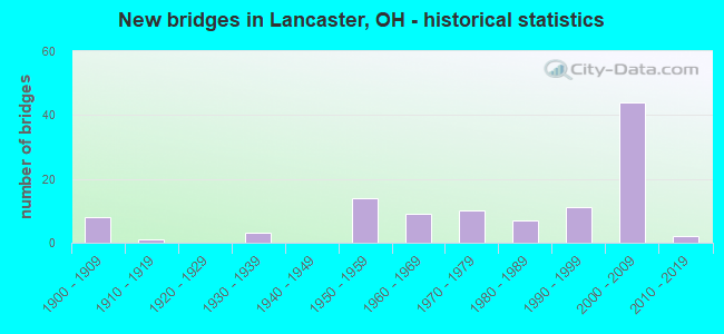
- New bridges - historical statistics
- 81900-1909
- 11910-1919
- 31930-1939
- 141950-1959
- 91960-1969
- 101970-1979
- 71980-1989
- 111990-1999
- 442000-2009
- 22010-2019

- Reconstructed bridges - Historical Statistics
- 31970-1979
- 81980-1989
- 71990-1999
- 22000-2009
- 22010-2019


- Bridge Condition - Deck
- 5.6%Excellent
- 34.8%Very good
- 37.1%Good
- 18.0%Satisfactory
- 4.5%Fair

- Bridge Condition - Superstructure
- 4.5%Excellent
- 43.8%Very good
- 25.8%Good
- 16.9%Satisfactory
- 7.9%Fair
- 1.1%Poor

- Bridge Condition - Substructure
- 2.2%Excellent
- 40.4%Very good
- 24.7%Good
- 25.8%Satisfactory
- 4.5%Fair
- 2.2%Poor

- Bridge Condition - Channel
- 10.1%Excellent
- 13.9%Very good
- 58.2%Good
- 13.9%Satisfactory
- 3.8%Fair

- Bridge Condition - Culverts
- 66.7%Very good
- 16.7%Good
- 16.7%Satisfactory
Find on map >> Show street view
Structure Number: 2300184, Location: 1.6 M W OF JCT US 33 (Lat: 39.702100, Lng: -82.631581), Route carried "on" structure: US 22, Year Built: 1952, Year Reconstructed: 1999, Status: Open, Structure Length: 1.55m (5.09ft), Average Daily Traffic: 8,841 (year 2015), Truck Traffic: 16%, Average Future Daily Traffic: 12,271 (year 2035), Design Load: HL 93, Features Intersected: HUNTERS RUN
Minimum Vertical Clearance: 30+ m (98+ ft), Kilometerpoint: 20.004, Lanes on structure: 2, Base Highway Network: Yes, Owner: State Highway Agency, Approaching Roadway Width: 12.2m (40.0ft), Skew: 3 degrees, Material/Design: Prestressed concrete, Design/Construction: Box Beam or Girders - Multiple, Number Of Spans In Main Unit: 1, Length of Maximum Span: 15.2m (49.9ft), Curb-To-Curb Width: 12.2m (40.0ft), Out-to-Out Width: 12.2m (40.0ft)
Condition: Deck: Very good, Superstructure: Very good, Substructure: Good, Channel: Good, Operating Rating: 94.0 metric tons, Method Used To Determine Operating Rating: Load and Resistance Factor Rating (LRFR) rating reported by rating factor(RF) method using HL-93 loadings, Inventory Rating: 68.0 metric tons, Method Used To Determine Inventory Rating: Load and Resistance Factor Rating (LRFR) rating reported by rating factor(RF) method using HL-93 loadings, Structural Evaluation: Better than present minimum criteria, Deck Geometry: Somewhat better than minimum adequacy, Waterway Adequacy: Equal to present desirable criteria, Approach Roadway Alignment: Better than present minimum criteria, Designated Inspection Frequency: Every 24 months, Inspection Date: June 2021, Deck Structure Type: Concrete Cast-file-Place, Wearing Surface/Protective System: Wearing Surface: Integral Concrete, Deck Protection: Epoxy Coated Reinforcing
Find on map >> Show street view
Structure Number: 2300222, Location: 1 M W OF JCT US 33 (Lat: 39.707269, Lng: -82.621889), Route carried "on" structure: US 22, Year Built: 1983, Status: Open, Structure Length: 2.62m (8.60ft), Average Daily Traffic: 10,071 (year 2015), Truck Traffic: 11%, Average Future Daily Traffic: 13,979 (year 2035), Design Load: HL 93, Features Intersected: HUNTERS RUN
Minimum Vertical Clearance: 30+ m (98+ ft), Kilometerpoint: 21.034, Lanes on structure: 2, Base Highway Network: Yes, Owner: State Highway Agency, Approaching Roadway Width: 9.8m (32.2ft), Skew: 1 degrees, Material/Design: Prestressed concrete, Design/Construction: Box Beam or Girders - Multiple, Number Of Spans In Main Unit: 3, Length of Maximum Span: 8.8m (28.9ft), Curb-To-Curb Width: 9.8m (32.2ft), Out-to-Out Width: 9.8m (32.2ft)
Condition: Deck: Good, Superstructure: Good, Substructure: Very good, Channel: Good, Operating Rating: 51.8 metric tons, Method Used To Determine Operating Rating: Load and Resistance Factor Rating (LRFR) rating reported by rating factor(RF) method using HL-93 loadings, Inventory Rating: 38.9 metric tons, Method Used To Determine Inventory Rating: Load and Resistance Factor Rating (LRFR) rating reported by rating factor(RF) method using HL-93 loadings, Structural Evaluation: Better than present minimum criteria, Deck Geometry: Meets minimum limits, Waterway Adequacy: Equal to present desirable criteria, Approach Roadway Alignment: Equal to present desirable criteria, Designated Inspection Frequency: Every 24 months, Inspection Date: June 2021, Deck Structure Type: Concrete Cast-file-Place, Wearing Surface/Protective System: Wearing Surface: Bituminous, Membrane: Built-up
Find on map >> Show street view
Structure Number: 2300257, Location: 2.9 M E OF JCT US 33 (Lat: 39.711200, Lng: -82.613839), Route carried "on" structure: US 22, Year Built: 1988, Status: Open, Structure Length: 1.86m (6.10ft), Average Daily Traffic: 16,638 (year 2015), Truck Traffic: 11%, Average Future Daily Traffic: 23,094 (year 2035), Design Load: HS 20+Mod, Features Intersected: HUNTERS RUN
Minimum Vertical Clearance: 30+ m (98+ ft), Kilometerpoint: 21.855, Lanes on structure: 3, Base Highway Network: Yes, Owner: State Highway Agency, Approaching Roadway Width: 11.0m (36.1ft), Skew: 1 degrees, Material/Design: Steel, Design/Construction: Stringer/Multi-beam, Number Of Spans In Main Unit: 1, Length of Maximum Span: 16.8m (55.1ft), Curb or Sidewalk Widths: Left: 1.5m (4.9ft), Right: 1.5m (4.9ft), Curb-To-Curb Width: 11.0m (36.1ft), Out-to-Out Width: 14.8m (48.6ft)
Condition: Deck: Good, Superstructure: Very good, Substructure: Good, Channel: Good, Operating Rating: 35.6 metric tons, Method Used To Determine Operating Rating: Load and Resistance Factor Rating (LRFR) rating reported by rating factor(RF) method using HL-93 loadings, Inventory Rating: 25.9 metric tons, Method Used To Determine Inventory Rating: Load and Resistance Factor Rating (LRFR) rating reported by rating factor(RF) method using HL-93 loadings, Structural Evaluation: Equal to present minimum criteria, Deck Geometry: High priority of replacement, Waterway Adequacy: Better than present minimum criteria, Approach Roadway Alignment: Better than present minimum criteria, Designated Inspection Frequency: Every 24 months, Inspection Date: June 2021, Deck Structure Type: Concrete Cast-file-Place, Wearing Surface/Protective System: Wearing Surface: Monolithic Concrete, Deck Protection: Epoxy Coated Reinforcing
Find on map >> Show street view
Structure Number: 2300273, Location: .2 M W OF JCT US 33 (Lat: 39.712911, Lng: -82.609211), Route carried "on" structure: US 22, Year Built: 1964, Status: Open, Structure Length: 2.44m (8.01ft), Average Daily Traffic: 12,183 (year 2015), Truck Traffic: 10%, Average Future Daily Traffic: 16,910 (year 2035), Design Load: HS 20, Features Intersected: HOCKING RIVER
Minimum Vertical Clearance: 30+ m (98+ ft), Kilometerpoint: 22.289, Lanes on structure: 3, Base Highway Network: Yes, Owner: State Highway Agency, Approaching Roadway Width: 10.7m (35.1ft), Skew: 1 degrees, Material/Design: Concrete continuous, Design/Construction: Slab, Number Of Spans In Main Unit: 3, Length of Maximum Span: 9.1m (29.9ft), Curb or Sidewalk Widths: Left: 1.5m (4.9ft), Right: 1.5m (4.9ft), Curb-To-Curb Width: 10.7m (35.1ft), Out-to-Out Width: 14.4m (47.2ft)
Condition: Deck: Good, Superstructure: Good, Substructure: Satisfactory, Channel: Good, Operating Rating: 51.8 metric tons, Method Used To Determine Operating Rating: Load Factor (LF) rating reported by rating factor (RF) method using MS18 loading, Inventory Rating: 29.2 metric tons, Method Used To Determine Inventory Rating: Load Factor (LF) rating reported by rating factor (RF) method using MS18 loading, Structural Evaluation: Equal to present minimum criteria, Deck Geometry: High priority of replacement, Waterway Adequacy: Better than present minimum criteria, Approach Roadway Alignment: Equal to present desirable criteria, Designated Inspection Frequency: Every 12 months, Inspection Date: June 2021, Deck Structure Type: Concrete Cast-file-Place, Wearing Surface/Protective System: Wearing Surface: Integral Concrete
Find on map >> Show street view
Structure Number: 2300303, Location: .1 M E OF JCT SR 158 (Lat: 39.713539, Lng: -82.581681), Route carried "on" structure: US 22, Year Built: 1932, Year Reconstructed: 2006, Status: Open, Structure Length: 1.92m (6.30ft), Average Daily Traffic: 20,764 (year 2015), Truck Traffic: 9%, Average Future Daily Traffic: 28,820 (year 2035), Design Load: HL 93, Features Intersected: BALDWIN RUN
Minimum Vertical Clearance: 30+ m (98+ ft), Kilometerpoint: 24.720, Lanes on structure: 4, Base Highway Network: Yes, Owner: State Highway Agency, Approaching Roadway Width: 17.4m (57.1ft), Skew: 1 degrees, Material/Design: Prestressed concrete, Design/Construction: Stringer/Multi-beam, Number Of Spans In Main Unit: 1, Length of Maximum Span: 18.9m (62.0ft), Curb or Sidewalk Widths: Left: 1.5m (4.9ft), Right: 1.5m (4.9ft), Curb-To-Curb Width: 17.4m (57.1ft), Out-to-Out Width: 20.8m (68.2ft)
Condition: Deck: Very good, Superstructure: Very good, Substructure: Very good, Channel: Good, Operating Rating: 45.4 metric tons, Method Used To Determine Operating Rating: Load and Resistance Factor Rating (LRFR) rating reported by rating factor(RF) method using HL-93 loadings, Inventory Rating: 29.2 metric tons, Method Used To Determine Inventory Rating: Load and Resistance Factor Rating (LRFR) rating reported by rating factor(RF) method using HL-93 loadings, Structural Evaluation: Better than present minimum criteria, Deck Geometry: Somewhat better than minimum adequacy, Waterway Adequacy: Better than present minimum criteria, Approach Roadway Alignment: Equal to present minimum criteria, Designated Inspection Frequency: Every 24 months, Inspection Date: June 2021, Deck Structure Type: Concrete Cast-file-Place, Wearing Surface/Protective System: Wearing Surface: Monolithic Concrete
Find on map >> Show street view
Structure Number: 2300338, Location: 1 M W OF JCT SR 37 (Lat: 39.716081, Lng: -82.550100), Route carried "on" structure: US 22, Year Built: 1972, Status: Open, Structure Length: 2.83m (9.28ft), Average Daily Traffic: 15,716 (year 2015), Truck Traffic: 9%, Average Future Daily Traffic: 21,814 (year 2035), Design Load: HS 20, Features Intersected: PLEASANT RUN
Minimum Vertical Clearance: 30+ m (98+ ft), Kilometerpoint: 27.455, Lanes on structure: 4, Base Highway Network: Yes, Owner: State Highway Agency, Approaching Roadway Width: 21.9m (71.9ft), Skew: 4 degrees, Material/Design: Concrete continuous, Design/Construction: Slab, Number Of Spans In Main Unit: 3, Length of Maximum Span: 10.7m (35.1ft), Curb-To-Curb Width: 20.7m (67.9ft), Out-to-Out Width: 20.7m (67.9ft)
Condition: Deck: Good, Superstructure: Good, Substructure: Fair, Channel: Good, Operating Rating: 61.6 metric tons, Method Used To Determine Operating Rating: Load Factor (LF) rating reported by rating factor (RF) method using MS18 loading, Inventory Rating: 38.9 metric tons, Method Used To Determine Inventory Rating: Load Factor (LF) rating reported by rating factor (RF) method using MS18 loading, Structural Evaluation: Somewhat better than minimum adequacy, Deck Geometry: Superior to present desirable criteria, Waterway Adequacy: Equal to present desirable criteria, Approach Roadway Alignment: Equal to present desirable criteria, Designated Inspection Frequency: Every 12 months, Inspection Date: June 2021, Deck Structure Type: Concrete Cast-file-Place, Wearing Surface/Protective System: Wearing Surface: Integral Concrete
Find on map >> Show street view
Structure Number: 230037, Location: .7 MI EAST OF JC SR 37 (Lat: 39.725811, Lng: -82.521961), Route carried "on" structure: US 22, Year Built: 1991, Status: Open, Structure Length: 2.19m (7.19ft), Average Daily Traffic: 5,536 (year 2015), Truck Traffic: 10%, Average Future Daily Traffic: 7,684 (year 2035), Design Load: HS 20+Mod, Features Intersected: TRIB OF RACCOON RUN
Minimum Vertical Clearance: 30+ m (98+ ft), Kilometerpoint: 30.127, Lanes on structure: 2, Base Highway Network: Yes, Owner: State Highway Agency, Approaching Roadway Width: 9.8m (32.2ft), Skew: 5 degrees, Material/Design: Prestressed concrete, Design/Construction: Box Beam or Girders - Multiple, Number Of Spans In Main Unit: 1, Length of Maximum Span: 19.8m (65.0ft), Curb-To-Curb Width: 9.8m (32.2ft), Out-to-Out Width: 9.8m (32.2ft)
Condition: Deck: Good, Superstructure: Good, Substructure: Very good, Channel: Good, Operating Rating: 58.3 metric tons, Method Used To Determine Operating Rating: Load Factor (LF) rating reported by rating factor (RF) method using MS18 loading, Inventory Rating: 25.9 metric tons, Method Used To Determine Inventory Rating: Load Factor (LF) rating reported by rating factor (RF) method using MS18 loading, Structural Evaluation: Equal to present minimum criteria, Deck Geometry: Meets minimum limits, Waterway Adequacy: Equal to present desirable criteria, Approach Roadway Alignment: Equal to present minimum criteria, Designated Inspection Frequency: Every 24 months, Inspection Date: June 2021, Deck Structure Type: Concrete Cast-file-Place, Wearing Surface/Protective System: Wearing Surface: Bituminous, Membrane: Built-up
Find on map >> Show street view
Structure Number: 2300761, Location: 1.5 M W OF JCT US 22 (Lat: 39.705739, Lng: -82.670011), Route carried "on" structure: US 33, Year Built: 2003, Status: Open, Structure Length: 0.67m (2.20ft), Average Daily Traffic: 19,566 (year 2015), Truck Traffic: 8%, Average Future Daily Traffic: 27,158 (year 2035), Design Load: HS 20+Mod, Features Intersected: US 33 OVER HUNTERS RUN
Minimum Vertical Clearance: 30+ m (98+ ft), Kilometerpoint: 22.000, Lanes on structure: 4, Base Highway Network: Yes, Owner: State Highway Agency, Approaching Roadway Width: 39.6m (129.9ft), Material/Design: Concrete, Design/Construction: Culvert, Number Of Spans In Main Unit: 1, Length of Maximum Span: 6.4m (21.0ft)
Condition: Channel: Good, Culverts: Very good, Operating Rating: 97.2 metric tons, Method Used To Determine Operating Rating: Load Factor (LF) rating reported by rating factor (RF) method using MS18 loading, Inventory Rating: 90.7 metric tons, Method Used To Determine Inventory Rating: Load Factor (LF) rating reported by rating factor (RF) method using MS18 loading, Structural Evaluation: Equal to present desirable criteria, Waterway Adequacy: Equal to present desirable criteria, Approach Roadway Alignment: Equal to present desirable criteria, Designated Inspection Frequency: Every 24 months, Inspection Date: October 2021
Find on map >> Show street view
Structure Number: 2300826, Location: 2.8 M W OF JCT SR 188 (Lat: 39.758939, Lng: -82.680919), Route carried "on" structure: US 33, Year Built: 2002, Status: Open, Structure Length: 4.47m (14.67ft), Average Daily Traffic: 10,544 (year 2015), Truck Traffic: 8%, Average Future Daily Traffic: 14,635 (year 2035), Design Load: HS 25 or greater, Features Intersected: WB US 33 OVER KELSEY RUN
Minimum Vertical Clearance: 30+ m (98+ ft), Kilometerpoint: 15.949, Lanes on structure: 2, Base Highway Network: Yes, Owner: State Highway Agency, Approaching Roadway Width: 15.9m (52.2ft), Skew: 5 degrees, Material/Design: Prestressed concrete, Design/Construction: Stringer/Multi-beam, Number Of Spans In Main Unit: 1, Length of Maximum Span: 43.2m (141.7ft), Curb-To-Curb Width: 15.9m (52.2ft), Out-to-Out Width: 16.9m (55.4ft)
Condition: Deck: Very good, Superstructure: Very good, Substructure: Very good, Channel: Satisfactory, Operating Rating: 84.2 metric tons, Method Used To Determine Operating Rating: Load and Resistance Factor Rating (LRFR) rating reported by rating factor(RF) method using HL-93 loadings, Inventory Rating: 61.6 metric tons, Method Used To Determine Inventory Rating: Load and Resistance Factor Rating (LRFR) rating reported by rating factor(RF) method using HL-93 loadings, Structural Evaluation: Equal to present desirable criteria, Deck Geometry: Superior to present desirable criteria, Waterway Adequacy: Equal to present desirable criteria, Approach Roadway Alignment: Equal to present desirable criteria, Designated Inspection Frequency: Every 24 months, Inspection Date: August 2021, Deck Structure Type: Concrete Cast-file-Place, Wearing Surface/Protective System: Wearing Surface: Monolithic Concrete, Membrane: Epoxy, Deck Protection: Epoxy Coated Reinforcing
Find on map >> Show street view
Structure Number: 2300834, Location: 3 M S OF LACASTER (Lat: 39.667561, Lng: -82.607081), Route carried "on" structure: County highway C0090, Year Built: 2004, Status: Open, Structure Length: 10.76m (35.30ft), Average Daily Traffic: 1,007 (year 2017), Truck Traffic: 4%, Average Future Daily Traffic: 1,398 (year 2037), Design Load: HS 25 or greater, Features Intersected: US 33 UNDER BIS ROAD, Facility Carried by Structure: BIS ROAD CR90
Minimum Vertical Clearance: 30+ m (98+ ft), Kilometerpoint: 2.808, Lanes on structure: 2, Lanes under structure: 4, Owner: State Highway Agency, Approaching Roadway Width: 11.0m (36.1ft), Skew: 4 degrees, Material/Design: Prestressed concrete, Design/Construction: Stringer/Multi-beam, Number Of Spans In Main Unit: 4, Length of Maximum Span: 28.0m (91.9ft), Curb-To-Curb Width: 11.0m (36.1ft), Out-to-Out Width: 12.0m (39.4ft)
Condition: Deck: Very good, Superstructure: Good, Substructure: Good, Operating Rating: 55.1 metric tons, Method Used To Determine Operating Rating: Load and Resistance Factor Rating (LRFR) rating reported by rating factor(RF) method using HL-93 loadings, Inventory Rating: 42.1 metric tons, Method Used To Determine Inventory Rating: Load and Resistance Factor Rating (LRFR) rating reported by rating factor(RF) method using HL-93 loadings, Structural Evaluation: Better than present minimum criteria, Deck Geometry: Equal to present minimum criteria, Underclear: Equal to present minimum criteria, Approach Roadway Alignment: Equal to present minimum criteria, Designated Inspection Frequency: Every 24 months, Inspection Date: November 2021, Deck Structure Type: Concrete Cast-file-Place, Wearing Surface/Protective System: Wearing Surface: Monolithic Concrete, Membrane: Epoxy, Deck Protection: Epoxy Coated Reinforcing
Find on map >> Show street view
Structure Number: 230085, Location: AT JCT US 22 AND US 33T (Lat: 39.687769, Lng: -82.659331), Route carried "on" structure: US 22, Year Built: 2004, Status: Open, Structure Length: 5.54m (18.18ft), Average Daily Traffic: 9,002 (year 2015), Truck Traffic: 17%, Average Future Daily Traffic: 12,495 (year 2035), Design Load: HS 25 or greater, Features Intersected: US 22 OVER US 33
Minimum Vertical Clearance: 30+ m (98+ ft), Kilometerpoint: 17.107, Lanes on structure: 5, Lanes under structure: 4, Base Highway Network: Yes, Owner: State Highway Agency, Approaching Roadway Width: 25.6m (84.0ft), Material/Design: Prestressed concrete, Design/Construction: Stringer/Multi-beam, Number Of Spans In Main Unit: 2, Length of Maximum Span: 27.0m (88.6ft), Curb-To-Curb Width: 25.6m (84.0ft), Out-to-Out Width: 26.7m (87.6ft)
Condition: Deck: Very good, Superstructure: Very good, Substructure: Very good, Operating Rating: 42.1 metric tons, Method Used To Determine Operating Rating: Load Factor (LF) rating reported by rating factor (RF) method using MS18 loading, Inventory Rating: 32.4 metric tons, Method Used To Determine Inventory Rating: Load Factor (LF) rating reported by rating factor (RF) method using MS18 loading, Structural Evaluation: Equal to present desirable criteria, Deck Geometry: Superior to present desirable criteria, Underclear: Equal to present desirable criteria, Approach Roadway Alignment: Equal to present desirable criteria, Designated Inspection Frequency: Every 24 months, Inspection Date: June 2021, Deck Structure Type: Concrete Cast-file-Place, Wearing Surface/Protective System: Wearing Surface: Monolithic Concrete, Membrane: Epoxy, Deck Protection: Epoxy Coated Reinforcing
Find on map >> Show street view
Structure Number: 2300869, Location: 3.8 MI E OF JCT US22 (Lat: 39.667269, Lng: -82.596211), Route carried "on" structure: County highway T0284, Year Built: 2004, Status: Open, Structure Length: 8.62m (28.28ft), Average Daily Traffic: 154 (year 2017), Truck Traffic: 5%, Average Future Daily Traffic: 214 (year 2037), Design Load: HS 25 or greater, Features Intersected: US 33 UNDER ROSS RD T284, Facility Carried by Structure: ROSS ROAD TR 284
Minimum Vertical Clearance: 30+ m (98+ ft), Kilometerpoint: 1.019, Lanes on structure: 2, Lanes under structure: 4, Owner: State Highway Agency, Approaching Roadway Width: 11.0m (36.1ft), Skew: 4 degrees, Material/Design: Prestressed concrete, Design/Construction: Stringer/Multi-beam, Number Of Spans In Main Unit: 2, Length of Maximum Span: 42.7m (140.1ft), Curb-To-Curb Width: 11.0m (36.1ft), Out-to-Out Width: 12.0m (39.4ft)
Condition: Deck: Very good, Superstructure: Very good, Substructure: Good, Operating Rating: 68.0 metric tons, Method Used To Determine Operating Rating: Load and Resistance Factor Rating (LRFR) rating reported by rating factor(RF) method using HL-93 loadings, Inventory Rating: 32.4 metric tons, Method Used To Determine Inventory Rating: Load and Resistance Factor Rating (LRFR) rating reported by rating factor(RF) method using HL-93 loadings, Structural Evaluation: Better than present minimum criteria, Deck Geometry: Equal to present desirable criteria, Underclear: Somewhat better than minimum adequacy, Approach Roadway Alignment: Equal to present minimum criteria, Designated Inspection Frequency: Every 24 months, Inspection Date: August 2021, Deck Structure Type: Concrete Cast-file-Place, Wearing Surface/Protective System: Wearing Surface: Monolithic Concrete, Membrane: Epoxy, Deck Protection: Epoxy Coated Reinforcing
Find on map >> Show street view
Structure Number: 2300885, Location: 2.8 M W OF JCT SR 188 (Lat: 39.758589, Lng: -82.680950), Route carried "on" structure: US 33, Year Built: 2002, Status: Open, Structure Length: 4.47m (14.67ft), Average Daily Traffic: 10,544 (year 2015), Truck Traffic: 8%, Average Future Daily Traffic: 14,635 (year 2035), Design Load: HS 25 or greater, Features Intersected: EB US 33 OVER KELSEY RUN
Minimum Vertical Clearance: 30+ m (98+ ft), Kilometerpoint: 15.949, Lanes on structure: 2, Base Highway Network: Yes, Owner: State Highway Agency, Approaching Roadway Width: 15.9m (52.2ft), Skew: 5 degrees, Material/Design: Prestressed concrete, Design/Construction: Stringer/Multi-beam, Number Of Spans In Main Unit: 1, Length of Maximum Span: 43.2m (141.7ft), Curb-To-Curb Width: 15.9m (52.2ft), Out-to-Out Width: 16.9m (55.4ft)
Condition: Deck: Very good, Superstructure: Very good, Substructure: Very good, Channel: Good, Operating Rating: 42.1 metric tons, Method Used To Determine Operating Rating: Load Factor (LF) rating reported by rating factor (RF) method using MS18 loading, Inventory Rating: 32.4 metric tons, Method Used To Determine Inventory Rating: Load Factor (LF) rating reported by rating factor (RF) method using MS18 loading, Structural Evaluation: Equal to present desirable criteria, Deck Geometry: Superior to present desirable criteria, Waterway Adequacy: Equal to present desirable criteria, Approach Roadway Alignment: Equal to present desirable criteria, Designated Inspection Frequency: Every 24 months, Inspection Date: August 2021, Deck Structure Type: Concrete Cast-file-Place, Wearing Surface/Protective System: Wearing Surface: Monolithic Concrete, Membrane: Epoxy, Deck Protection: Epoxy Coated Reinforcing
Find on map >> Show street view
Structure Number: 2300893, Location: 2 MI WEST OF JCT SR 188 (Lat: 39.747300, Lng: -82.677189), Route carried "on" structure: US 33, Year Built: 2002, Status: Open, Structure Length: 3.72m (12.20ft), Average Daily Traffic: 10,544 (year 2015), Truck Traffic: 8%, Average Future Daily Traffic: 14,635 (year 2035), Design Load: HS 25 or greater, Features Intersected: WB US 33 OVER LITHOPOLIS
Minimum Vertical Clearance: 30+ m (98+ ft), Kilometerpoint: 17.300, Lanes on structure: 2, Lanes under structure: 2, Base Highway Network: Yes, Owner: State Highway Agency, Approaching Roadway Width: 15.9m (52.2ft), Skew: 1 degrees, Material/Design: Prestressed concrete, Design/Construction: Stringer/Multi-beam, Number Of Spans In Main Unit: 3, Length of Maximum Span: 16.0m (52.5ft), Curb-To-Curb Width: 15.9m (52.2ft), Out-to-Out Width: 16.9m (55.4ft)
Condition: Deck: Very good, Superstructure: Very good, Substructure: Very good, Operating Rating: 48.6 metric tons, Method Used To Determine Operating Rating: Load and Resistance Factor Rating (LRFR) rating reported by rating factor(RF) method using HL-93 loadings, Inventory Rating: 38.9 metric tons, Method Used To Determine Inventory Rating: Load and Resistance Factor Rating (LRFR) rating reported by rating factor(RF) method using HL-93 loadings, Structural Evaluation: Equal to present desirable criteria, Deck Geometry: Superior to present desirable criteria, Underclear: Better than present minimum criteria, Approach Roadway Alignment: Equal to present minimum criteria, Designated Inspection Frequency: Every 24 months, Inspection Date: August 2021, Deck Structure Type: Concrete Cast-file-Place, Wearing Surface/Protective System: Wearing Surface: Monolithic Concrete, Membrane: Epoxy, Deck Protection: Epoxy Coated Reinforcing
Find on map >> Show street view
Structure Number: 2300915, Location: 5.5 M E OF JCT US 22 (Lat: 39.664619, Lng: -82.564350), Route carried "on" structure: US 33, Year Built: 2005, Status: Open, Structure Length: 4.94m (16.21ft), Average Daily Traffic: 7,182 (year 2015), Truck Traffic: 8%, Average Future Daily Traffic: 9,969 (year 2035), Design Load: HS 25 or greater, Features Intersected: EB US 33 OVER TARKLIN RD
Minimum Vertical Clearance: 30+ m (98+ ft), Kilometerpoint: 33.249, Lanes on structure: 2, Lanes under structure: 3, Base Highway Network: Yes, Owner: State Highway Agency, Approaching Roadway Width: 15.9m (52.2ft), Skew: 4 degrees, Material/Design: Prestressed concrete, Design/Construction: Stringer/Multi-beam, Number Of Spans In Main Unit: 1, Length of Maximum Span: 48.9m (160.4ft), Curb-To-Curb Width: 15.9m (52.2ft), Out-to-Out Width: 16.9m (55.4ft)
Condition: Deck: Very good, Superstructure: Very good, Substructure: Very good, Operating Rating: 64.8 metric tons, Method Used To Determine Operating Rating: Load and Resistance Factor Rating (LRFR) rating reported by rating factor(RF) method using HL-93 loadings, Inventory Rating: 48.6 metric tons, Method Used To Determine Inventory Rating: Load and Resistance Factor Rating (LRFR) rating reported by rating factor(RF) method using HL-93 loadings, Structural Evaluation: Equal to present desirable criteria, Deck Geometry: Superior to present desirable criteria, Underclear: Superior to present desirable criteria, Approach Roadway Alignment: Equal to present desirable criteria, Designated Inspection Frequency: Every 24 months, Inspection Date: September 2021, Deck Structure Type: Concrete Cast-file-Place, Wearing Surface/Protective System: Wearing Surface: Monolithic Concrete, Membrane: Epoxy, Deck Protection: Epoxy Coated Reinforcing
Find on map >> Show street view
Structure Number: 2300923, Location: 1.7 M W OF JCT SR 188 (Lat: 39.743361, Lng: -82.677700), Route carried "on" structure: US 33, Year Built: 2002, Status: Open, Structure Length: 10.74m (35.24ft), Average Daily Traffic: 10,544 (year 2015), Truck Traffic: 8%, Average Future Daily Traffic: 14,635 (year 2035), Design Load: HS 25 or greater, Features Intersected: WB US 33 OVER HOCKING RV
Minimum Vertical Clearance: 30+ m (98+ ft), Kilometerpoint: 17.735, Lanes on structure: 2, Base Highway Network: Yes, Owner: State Highway Agency, Approaching Roadway Width: 15.9m (52.2ft), Skew: 3 degrees, Material/Design: Steel continuous, Design/Construction: Stringer/Multi-beam, Number Of Spans In Main Unit: 4, Length of Maximum Span: 32.0m (105.0ft), Curb-To-Curb Width: 15.9m (52.2ft), Out-to-Out Width: 16.9m (55.4ft)
Condition: Deck: Very good, Superstructure: Very good, Substructure: Very good, Channel: Fair, Operating Rating: 67.4 metric tons, Method Used To Determine Operating Rating: Load Factor (LF) rating reported by rating factor (RF) method using MS18 loading, Inventory Rating: 40.2 metric tons, Method Used To Determine Inventory Rating: Load Factor (LF) rating reported by rating factor (RF) method using MS18 loading, Structural Evaluation: Equal to present desirable criteria, Deck Geometry: Superior to present desirable criteria, Waterway Adequacy: Equal to present desirable criteria, Approach Roadway Alignment: Equal to present desirable criteria, Designated Inspection Frequency: Every 24 months, Inspection Date: August 2021, Deck Structure Type: Concrete Cast-file-Place, Wearing Surface/Protective System: Wearing Surface: Monolithic Concrete, Membrane: Epoxy, Deck Protection: Epoxy Coated Reinforcing
Find on map >> Show street view
Structure Number: 2300958, Location: 5.5 M E OF JCT US 22 (Lat: 39.664619, Lng: -82.563989), Route carried "on" structure: US 33, Year Built: 2005, Status: Open, Structure Length: 4.83m (15.85ft), Average Daily Traffic: 7,182 (year 2015), Truck Traffic: 8%, Average Future Daily Traffic: 9,969 (year 2035), Design Load: HS 25 or greater, Features Intersected: WB US 33 OVER TARKLIN RD
Minimum Vertical Clearance: 30+ m (98+ ft), Kilometerpoint: 33.249, Lanes on structure: 2, Lanes under structure: 3, Base Highway Network: Yes, Owner: State Highway Agency, Approaching Roadway Width: 15.9m (52.2ft), Skew: 4 degrees, Material/Design: Prestressed concrete, Design/Construction: Stringer/Multi-beam, Number Of Spans In Main Unit: 1, Length of Maximum Span: 47.8m (156.8ft), Curb-To-Curb Width: 15.9m (52.2ft), Out-to-Out Width: 16.9m (55.4ft)
Condition: Deck: Very good, Superstructure: Very good, Substructure: Very good, Operating Rating: 64.8 metric tons, Method Used To Determine Operating Rating: Load and Resistance Factor Rating (LRFR) rating reported by rating factor(RF) method using HL-93 loadings, Inventory Rating: 48.6 metric tons, Method Used To Determine Inventory Rating: Load and Resistance Factor Rating (LRFR) rating reported by rating factor(RF) method using HL-93 loadings, Structural Evaluation: Equal to present desirable criteria, Deck Geometry: Superior to present desirable criteria, Underclear: Superior to present desirable criteria, Approach Roadway Alignment: Equal to present desirable criteria, Designated Inspection Frequency: Every 24 months, Inspection Date: September 2021, Deck Structure Type: Concrete Cast-file-Place, Wearing Surface/Protective System: Wearing Surface: Monolithic Concrete, Membrane: Epoxy, Deck Protection: Epoxy Coated Reinforcing
Find on map >> Show street view
Structure Number: 2300982, Location: 1 M WEST OF JCT SR 188 (Lat: 39.735111, Lng: -82.679319), Route carried "on" structure: County highway C0045, Year Built: 2002, Status: Open, Structure Length: 8.42m (27.62ft), Average Daily Traffic: 1,985 (year 2015), Truck Traffic: 5%, Average Future Daily Traffic: 2,755 (year 2035), Design Load: HS 25 or greater, Features Intersected: US 33 UNDER WILSON RD, Facility Carried by Structure: WILSON ROAD CR 45
Minimum Vertical Clearance: 30+ m (98+ ft), Kilometerpoint: 11.354, Lanes on structure: 2, Lanes under structure: 4, Owner: State Highway Agency, Approaching Roadway Width: 11.0m (36.1ft), Material/Design: Steel continuous, Design/Construction: Stringer/Multi-beam, Number Of Spans In Main Unit: 4, Length of Maximum Span: 26.0m (85.3ft), Curb-To-Curb Width: 11.0m (36.1ft), Out-to-Out Width: 12.0m (39.4ft)
Condition: Deck: Good, Superstructure: Good, Substructure: Very good, Operating Rating: 51.8 metric tons, Method Used To Determine Operating Rating: Load and Resistance Factor Rating (LRFR) rating reported by rating factor(RF) method using HL-93 loadings, Inventory Rating: 38.9 metric tons, Method Used To Determine Inventory Rating: Load and Resistance Factor Rating (LRFR) rating reported by rating factor(RF) method using HL-93 loadings, Structural Evaluation: Better than present minimum criteria, Deck Geometry: Equal to present minimum criteria, Underclear: Better than present minimum criteria, Approach Roadway Alignment: Somewhat better than minimum adequacy, Designated Inspection Frequency: Every 24 months, Inspection Date: August 2021, Deck Structure Type: Concrete Cast-file-Place, Wearing Surface/Protective System: Wearing Surface: Monolithic Concrete, Membrane: Epoxy, Deck Protection: Epoxy Coated Reinforcing
Find on map >> Show street view
Structure Number: 2301016, Location: AT JCT OF US 33 (Lat: 39.718161, Lng: -82.675031), Route carried "on" structure: State highway 188, Year Built: 2002, Status: Open, Structure Length: 6.27m (20.57ft), Average Daily Traffic: 3,649 (year 2015), Truck Traffic: 12%, Average Future Daily Traffic: 5,065 (year 2035), Design Load: HS 25 or greater, Features Intersected: SR 188 OVER US 33
Minimum Vertical Clearance: 30+ m (98+ ft), Kilometerpoint: 15.096, Lanes on structure: 4, Lanes under structure: 4, Owner: State Highway Agency, Approaching Roadway Width: 21.9m (71.9ft), Skew: 2 degrees, Material/Design: Prestressed concrete, Design/Construction: Stringer/Multi-beam, Number Of Spans In Main Unit: 2, Length of Maximum Span: 30.2m (99.1ft), Curb-To-Curb Width: 21.9m (71.9ft), Out-to-Out Width: 23.0m (75.5ft)
Condition: Deck: Very good, Superstructure: Very good, Substructure: Good, Operating Rating: 51.8 metric tons, Method Used To Determine Operating Rating: Load and Resistance Factor Rating (LRFR) rating reported by rating factor(RF) method using HL-93 loadings, Inventory Rating: 42.1 metric tons, Method Used To Determine Inventory Rating: Load and Resistance Factor Rating (LRFR) rating reported by rating factor(RF) method using HL-93 loadings, Structural Evaluation: Better than present minimum criteria, Deck Geometry: Superior to present desirable criteria, Underclear: Equal to present minimum criteria, Approach Roadway Alignment: Better than present minimum criteria, Designated Inspection Frequency: Every 24 months, Inspection Date: July 2021, Deck Structure Type: Concrete Cast-file-Place, Wearing Surface/Protective System: Wearing Surface: Monolithic Concrete, Membrane: Epoxy, Deck Protection: Epoxy Coated Reinforcing
Find on map >> Show street view
Structure Number: 2301032, Location: 1.7 M W OF JCT SR 188 (Lat: 39.743219, Lng: -82.678019), Route carried "on" structure: US 33, Year Built: 2002, Status: Open, Structure Length: 9.68m (31.76ft), Average Daily Traffic: 10,544 (year 2015), Truck Traffic: 8%, Average Future Daily Traffic: 14,635 (year 2035), Design Load: HS 25 or greater, Features Intersected: US 33 EB OVER HOCKING RV
Minimum Vertical Clearance: 30+ m (98+ ft), Kilometerpoint: 17.735, Lanes on structure: 2, Base Highway Network: Yes, Owner: State Highway Agency, Approaching Roadway Width: 15.9m (52.2ft), Skew: 3 degrees, Material/Design: Steel continuous, Design/Construction: Stringer/Multi-beam, Number Of Spans In Main Unit: 4, Length of Maximum Span: 32.0m (105.0ft), Curb-To-Curb Width: 15.9m (52.2ft), Out-to-Out Width: 17.2m (56.4ft)
Condition: Deck: Very good, Superstructure: Very good, Substructure: Very good, Channel: Fair, Operating Rating: 68.7 metric tons, Method Used To Determine Operating Rating: Load Factor (LF) rating reported by rating factor (RF) method using MS18 loading, Inventory Rating: 41.1 metric tons, Method Used To Determine Inventory Rating: Load Factor (LF) rating reported by rating factor (RF) method using MS18 loading, Structural Evaluation: Equal to present desirable criteria, Deck Geometry: Superior to present desirable criteria, Waterway Adequacy: Equal to present desirable criteria, Approach Roadway Alignment: Equal to present desirable criteria, Designated Inspection Frequency: Every 24 months, Inspection Date: August 2021, Deck Structure Type: Concrete Cast-file-Place, Wearing Surface/Protective System: Wearing Surface: Monolithic Concrete, Membrane: Epoxy, Deck Protection: Epoxy Coated Reinforcing
Find on map >> Show street view
Structure Number: 230104, Location: 2 MI WEST OF JCT SR 188 (Lat: 39.747250, Lng: -82.677489), Route carried "on" structure: US 33, Year Built: 2002, Status: Open, Structure Length: 3.72m (12.20ft), Average Daily Traffic: 10,544 (year 2015), Truck Traffic: 8%, Average Future Daily Traffic: 14,635 (year 2035), Design Load: HS 25 or greater, Features Intersected: EB US 33 OVER LITHOPOLIS
Minimum Vertical Clearance: 30+ m (98+ ft), Kilometerpoint: 17.300, Lanes on structure: 2, Lanes under structure: 2, Base Highway Network: Yes, Owner: State Highway Agency, Approaching Roadway Width: 15.9m (52.2ft), Skew: 1 degrees, Material/Design: Prestressed concrete, Design/Construction: Stringer/Multi-beam, Number Of Spans In Main Unit: 3, Length of Maximum Span: 16.0m (52.5ft), Curb-To-Curb Width: 15.9m (52.2ft), Out-to-Out Width: 16.9m (55.4ft)
Condition: Deck: Very good, Superstructure: Very good, Substructure: Very good, Operating Rating: 48.6 metric tons, Method Used To Determine Operating Rating: Load and Resistance Factor Rating (LRFR) rating reported by rating factor(RF) method using HL-93 loadings, Inventory Rating: 38.9 metric tons, Method Used To Determine Inventory Rating: Load and Resistance Factor Rating (LRFR) rating reported by rating factor(RF) method using HL-93 loadings, Structural Evaluation: Equal to present desirable criteria, Deck Geometry: Superior to present desirable criteria, Underclear: High priority of corrective action, Approach Roadway Alignment: Equal to present minimum criteria, Designated Inspection Frequency: Every 24 months, Inspection Date: August 2021, Deck Structure Type: Concrete Cast-file-Place, Wearing Surface/Protective System: Wearing Surface: Monolithic Concrete, Membrane: Epoxy, Deck Protection: Epoxy Coated Reinforcing
Find on map >> Show street view
Structure Number: 2301067, Location: .3 MI EAST OF JCT SR 188 (Lat: 39.713411, Lng: -82.673611), Route carried "on" structure: County highway C0030, Year Built: 2002, Status: Open, Structure Length: 12.87m (42.22ft), Average Daily Traffic: 1,047 (year 2017), Truck Traffic: 7%, Average Future Daily Traffic: 1,453 (year 2037), Design Load: HS 25 or greater, Features Intersected: US 33 UNDER CR 30, Facility Carried by Structure: CR 30 DELMONT ROAD
Minimum Vertical Clearance: 30+ m (98+ ft), Kilometerpoint: 7.862, Lanes on structure: 2, Lanes under structure: 6, Owner: State Highway Agency, Approaching Roadway Width: 11.0m (36.1ft), Skew: 3 degrees, Material/Design: Steel continuous, Design/Construction: Stringer/Multi-beam, Number Of Spans In Main Unit: 4, Length of Maximum Span: 39.9m (130.9ft), Curb-To-Curb Width: 11.0m (36.1ft), Out-to-Out Width: 12.0m (39.4ft)
Condition: Deck: Very good, Superstructure: Very good, Substructure: Very good, Operating Rating: 42.1 metric tons, Method Used To Determine Operating Rating: Load Factor (LF) rating reported by rating factor (RF) method using MS18 loading, Inventory Rating: 32.4 metric tons, Method Used To Determine Inventory Rating: Load Factor (LF) rating reported by rating factor (RF) method using MS18 loading, Structural Evaluation: Equal to present desirable criteria, Deck Geometry: Equal to present minimum criteria, Underclear: Better than present minimum criteria, Approach Roadway Alignment: Somewhat better than minimum adequacy, Designated Inspection Frequency: Every 24 months, Inspection Date: August 2021, Deck Structure Type: Concrete Cast-file-Place, Wearing Surface/Protective System: Wearing Surface: Monolithic Concrete, Membrane: Epoxy, Deck Protection: Epoxy Coated Reinforcing
Find on map >> Show street view
Structure Number: 2301091, Location: 1 MI WEST OF JCT US 22 (Lat: 39.699089, Lng: -82.667381), Route carried "on" structure: US 33, Year Built: 2003, Status: Open, Structure Length: 5.60m (18.37ft), Average Daily Traffic: 9,783 (year 2015), Truck Traffic: 8%, Average Future Daily Traffic: 13,579 (year 2035), Design Load: HS 25 or greater, Features Intersected: EB US33 OVER CR 57
Minimum Vertical Clearance: 30+ m (98+ ft), Kilometerpoint: 22.804, Lanes on structure: 2, Lanes under structure: 2, Base Highway Network: Yes, Owner: State Highway Agency, Approaching Roadway Width: 16.1m (52.8ft), Skew: 2 degrees, Material/Design: Prestressed concrete, Design/Construction: Stringer/Multi-beam, Number Of Spans In Main Unit: 3, Length of Maximum Span: 23.7m (77.8ft), Curb-To-Curb Width: 16.1m (52.8ft), Out-to-Out Width: 17.2m (56.4ft)
Condition: Deck: Very good, Superstructure: Very good, Substructure: Very good, Operating Rating: 45.4 metric tons, Method Used To Determine Operating Rating: Load and Resistance Factor Rating (LRFR) rating reported by rating factor(RF) method using HL-93 loadings, Inventory Rating: 29.2 metric tons, Method Used To Determine Inventory Rating: Load and Resistance Factor Rating (LRFR) rating reported by rating factor(RF) method using HL-93 loadings, Structural Evaluation: Better than present minimum criteria, Deck Geometry: Superior to present desirable criteria, Underclear: Superior to present desirable criteria, Approach Roadway Alignment: Equal to present minimum criteria, Designated Inspection Frequency: Every 24 months, Inspection Date: August 2021, Deck Structure Type: Concrete Cast-file-Place, Wearing Surface/Protective System: Wearing Surface: Monolithic Concrete, Membrane: Epoxy, Deck Protection: Epoxy Coated Reinforcing
Find on map >> Show street view
Structure Number: 2301105, Location: 1 MI WEST OF JCT US 22 (Lat: 39.699061, Lng: -82.667061), Route carried "on" structure: US 33, Year Built: 2003, Status: Open, Structure Length: 5.60m (18.37ft), Average Daily Traffic: 9,783 (year 2015), Truck Traffic: 8%, Average Future Daily Traffic: 13,579 (year 2035), Design Load: HS 25 or greater, Features Intersected: WB US 33 OVER CR 57
Minimum Vertical Clearance: 30+ m (98+ ft), Kilometerpoint: 22.804, Lanes on structure: 2, Lanes under structure: 2, Base Highway Network: Yes, Owner: State Highway Agency, Approaching Roadway Width: 16.1m (52.8ft), Skew: 2 degrees, Material/Design: Prestressed concrete, Design/Construction: Stringer/Multi-beam, Number Of Spans In Main Unit: 3, Length of Maximum Span: 23.7m (77.8ft), Curb-To-Curb Width: 16.1m (52.8ft), Out-to-Out Width: 17.2m (56.4ft)
Condition: Deck: Very good, Superstructure: Very good, Substructure: Very good, Operating Rating: 42.1 metric tons, Method Used To Determine Operating Rating: Load Factor (LF) rating reported by rating factor (RF) method using MS18 loading, Inventory Rating: 32.4 metric tons, Method Used To Determine Inventory Rating: Load Factor (LF) rating reported by rating factor (RF) method using MS18 loading, Structural Evaluation: Equal to present desirable criteria, Deck Geometry: Superior to present desirable criteria, Underclear: Superior to present desirable criteria, Approach Roadway Alignment: Equal to present minimum criteria, Designated Inspection Frequency: Every 24 months, Inspection Date: August 2021, Deck Structure Type: Concrete Cast-file-Place, Wearing Surface/Protective System: Wearing Surface: Monolithic Concrete, Membrane: Epoxy, Deck Protection: Epoxy Coated Reinforcing
Find on map >> Show street view
Structure Number: 2301148, Location: 1.5 MI EAST OF JCT US 22 (Lat: 39.673069, Lng: -82.636750), Route carried "on" structure: County highway C0055, Year Built: 2003, Status: Open, Structure Length: 6.29m (20.64ft), Average Daily Traffic: 1,262 (year 2017), Truck Traffic: 5%, Average Future Daily Traffic: 1,752 (year 2037), Design Load: HS 25 or greater, Features Intersected: US 33 UNDER HAMBURG CR55, Facility Carried by Structure: HAMBURG RD, CR 55
Minimum Vertical Clearance: 30+ m (98+ ft), Kilometerpoint: 10.589, Lanes on structure: 2, Lanes under structure: 4, Owner: State Highway Agency, Approaching Roadway Width: 12.2m (40.0ft), Skew: 2 degrees, Material/Design: Prestressed concrete, Design/Construction: Stringer/Multi-beam, Number Of Spans In Main Unit: 2, Length of Maximum Span: 30.5m (100.1ft), Curb-To-Curb Width: 12.2m (40.0ft), Out-to-Out Width: 13.3m (43.6ft)
Condition: Deck: Good, Superstructure: Very good, Substructure: Good, Operating Rating: 51.8 metric tons, Method Used To Determine Operating Rating: Load and Resistance Factor Rating (LRFR) rating reported by rating factor(RF) method using HL-93 loadings, Inventory Rating: 38.9 metric tons, Method Used To Determine Inventory Rating: Load and Resistance Factor Rating (LRFR) rating reported by rating factor(RF) method using HL-93 loadings, Structural Evaluation: Better than present minimum criteria, Deck Geometry: Better than present minimum criteria, Underclear: Better than present minimum criteria, Approach Roadway Alignment: Equal to present minimum criteria, Designated Inspection Frequency: Every 24 months, Inspection Date: August 2021, Deck Structure Type: Concrete Cast-file-Place, Wearing Surface/Protective System: Wearing Surface: Monolithic Concrete, Membrane: Epoxy, Deck Protection: Epoxy Coated Reinforcing
Find on map >> Show street view
Structure Number: 2301288, Location: 2.6 M W OF JCT US 22 (Lat: 39.746519, Lng: -82.585700), Route carried "on" structure: State highway 37, Year Built: 1979, Status: Open, Structure Length: 3.05m (10.01ft), Average Daily Traffic: 9,104 (year 2018), Truck Traffic: 10%, Average Future Daily Traffic: 12,636 (year 2038), Design Load: HS 20+Mod, Features Intersected: FETTERS RUN
Minimum Vertical Clearance: 30+ m (98+ ft), Kilometerpoint: 20.938, Lanes on structure: 2, Base Highway Network: Yes, Owner: State Highway Agency, Approaching Roadway Width: 14.3m (46.9ft), Skew: 2 degrees, Material/Design: Concrete continuous, Design/Construction: Slab, Number Of Spans In Main Unit: 3, Length of Maximum Span: 11.0m (36.1ft), Curb-To-Curb Width: 14.9m (48.9ft), Out-to-Out Width: 14.9m (48.9ft)
Condition: Deck: Good, Superstructure: Good, Substructure: Fair, Channel: Good, Operating Rating: 64.8 metric tons, Method Used To Determine Operating Rating: Load Factor (LF) rating reported by rating factor (RF) method using MS18 loading, Inventory Rating: 38.9 metric tons, Method Used To Determine Inventory Rating: Load Factor (LF) rating reported by rating factor (RF) method using MS18 loading, Structural Evaluation: Somewhat better than minimum adequacy, Deck Geometry: Superior to present desirable criteria, Waterway Adequacy: Equal to present desirable criteria, Approach Roadway Alignment: Better than present minimum criteria, Designated Inspection Frequency: Every 12 months, Inspection Date: May 2021, Deck Structure Type: Concrete Cast-file-Place, Wearing Surface/Protective System: Wearing Surface: Bituminous, Membrane: Built-up
Find on map >> Show street view
Structure Number: 2301326, Location: .4 M E OF JCT US 22 (Lat: 39.720961, Lng: -82.525511), Route carried "on" structure: State highway 37, Year Built: 1965, Year Reconstructed: 2014, Status: Open, Structure Length: 2.07m (6.79ft), Average Daily Traffic: 8,300 (year 2013), Truck Traffic: 4%, Average Future Daily Traffic: 9,960 (year 2033), Design Load: H 20, Features Intersected: TRIBUTARY OF RACCOON RUN
Minimum Vertical Clearance: 30+ m (98+ ft), Kilometerpoint: 31.575, Lanes on structure: 2, Owner: State Highway Agency, Approaching Roadway Width: 13.4m (44.0ft), Skew: 1 degrees, Material/Design: Concrete continuous, Design/Construction: Slab, Number Of Spans In Main Unit: 3, Length of Maximum Span: 7.7m (25.3ft), Curb-To-Curb Width: 13.4m (44.0ft), Out-to-Out Width: 13.4m (44.0ft)
Condition: Deck: Good, Superstructure: Very good, Substructure: Very good, Channel: Very good, Operating Rating: 55.1 metric tons, Method Used To Determine Operating Rating: Load Factor (LF) rating reported by rating factor (RF) method using MS18 loading, Inventory Rating: 32.4 metric tons, Method Used To Determine Inventory Rating: Load Factor (LF) rating reported by rating factor (RF) method using MS18 loading, Structural Evaluation: Equal to present desirable criteria, Deck Geometry: Equal to present minimum criteria, Waterway Adequacy: Better than present minimum criteria, Approach Roadway Alignment: Equal to present desirable criteria, Designated Inspection Frequency: Every 24 months, Inspection Date: May 2021, Deck Structure Type: Concrete Cast-file-Place, Wearing Surface/Protective System: Wearing Surface: Integral Concrete
Find on map >> Show street view
Structure Number: 230135, Location: 2.3 M E OF JCT US 22 (Lat: 39.717439, Lng: -82.489689), Route carried "on" structure: State highway 37, Year Built: 1965, Status: Open, Structure Length: 2.62m (8.60ft), Average Daily Traffic: 6,655 (year 2018), Truck Traffic: 12%, Average Future Daily Traffic: 9,237 (year 2038), Design Load: H 20, Features Intersected: RACCOON RUN
Minimum Vertical Clearance: 30+ m (98+ ft), Kilometerpoint: 34.697, Lanes on structure: 2, Owner: State Highway Agency, Approaching Roadway Width: 14.0m (45.9ft), Skew: 3 degrees, Material/Design: Concrete continuous, Design/Construction: Slab, Number Of Spans In Main Unit: 3, Length of Maximum Span: 10.1m (33.1ft), Curb-To-Curb Width: 13.4m (44.0ft), Out-to-Out Width: 13.4m (44.0ft)
Condition: Deck: Fair, Superstructure: Fair, Substructure: Poor, Channel: Fair, Operating Rating: 55.1 metric tons, Method Used To Determine Operating Rating: Load Factor (LF) rating reported by rating factor (RF) method using MS18 loading, Inventory Rating: 32.4 metric tons, Method Used To Determine Inventory Rating: Load Factor (LF) rating reported by rating factor (RF) method using MS18 loading, Structural Evaluation: Meets minimum limits, Deck Geometry: Equal to present minimum criteria, Waterway Adequacy: Better than present minimum criteria, Approach Roadway Alignment: Equal to present desirable criteria, Designated Inspection Frequency: Every 12 months, Inspection Date: May 2021, Deck Structure Type: Concrete Cast-file-Place, Wearing Surface/Protective System: Wearing Surface: Bituminous
Find on map >> Show street view
Structure Number: 2302225, Location: 5.6 M E OF PIC CO LINE (Lat: 39.709169, Lng: -82.744261), Route carried "on" structure: State highway 188, Year Built: 1930, Year Reconstructed: 1980, Status: Open, Structure Length: 0.82m (2.69ft), Average Daily Traffic: 2,393 (year 2015), Truck Traffic: 13%, Average Future Daily Traffic: 3,321 (year 2035), Design Load: HS 20, Features Intersected: TRIBUTARY OF CLEAR CREEK
Minimum Vertical Clearance: 30+ m (98+ ft), Kilometerpoint: 8.932, Lanes on structure: 2, Owner: State Highway Agency, Approaching Roadway Width: 9.1m (29.9ft), Skew: 3 degrees, Material/Design: Concrete, Design/Construction: Slab, Number Of Spans In Main Unit: 1, Length of Maximum Span: 7.6m (24.9ft), Curb-To-Curb Width: 10.4m (34.1ft), Out-to-Out Width: 10.4m (34.1ft)
Condition: Deck: Good, Superstructure: Good, Substructure: Satisfactory, Channel: Good, Operating Rating: 55.1 metric tons, Method Used To Determine Operating Rating: Load and Resistance Factor Rating (LRFR) rating reported by rating factor(RF) method using HL-93 loadings, Inventory Rating: 42.1 metric tons, Method Used To Determine Inventory Rating: Load and Resistance Factor Rating (LRFR) rating reported by rating factor(RF) method using HL-93 loadings, Structural Evaluation: Equal to present minimum criteria, Deck Geometry: Somewhat better than minimum adequacy, Waterway Adequacy: Better than present minimum criteria, Approach Roadway Alignment: Meets minimum limits, Designated Inspection Frequency: Every 12 months, Inspection Date: July 2021, Deck Structure Type: Concrete Cast-file-Place, Wearing Surface/Protective System: Wearing Surface: Bituminous
Find on map >> Show street view
Structure Number: 2302357, Location: 8.6 M E OF PIC CO LINE (Lat: 39.716239, Lng: -82.689961), Route carried "on" structure: State highway 188, Year Built: 1989, Status: Open, Structure Length: 0.79m (2.59ft), Average Daily Traffic: 2,393 (year 2015), Truck Traffic: 12%, Average Future Daily Traffic: 3,321 (year 2035), Design Load: HS 20+Mod, Features Intersected: HUNTERS RUN
Minimum Vertical Clearance: 30+ m (98+ ft), Kilometerpoint: 13.824, Lanes on structure: 2, Owner: State Highway Agency, Approaching Roadway Width: 10.4m (34.1ft), Material/Design: Prestressed concrete, Design/Construction: Box Beam or Girders - Multiple, Number Of Spans In Main Unit: 1, Length of Maximum Span: 7.6m (24.9ft), Curb-To-Curb Width: 9.1m (29.9ft), Out-to-Out Width: 9.1m (29.9ft)
Condition: Deck: Very good, Superstructure: Very good, Substructure: Very good, Channel: Good, Operating Rating: 42.1 metric tons, Method Used To Determine Operating Rating: Load Factor (LF) rating reported by rating factor (RF) method using MS18 loading, Inventory Rating: 32.4 metric tons, Method Used To Determine Inventory Rating: Load Factor (LF) rating reported by rating factor (RF) method using MS18 loading, Structural Evaluation: Equal to present desirable criteria, Deck Geometry: Meets minimum limits, Waterway Adequacy: Equal to present desirable criteria, Approach Roadway Alignment: Equal to present desirable criteria, Designated Inspection Frequency: Every 24 months, Inspection Date: July 2021, Deck Structure Type: Concrete Cast-file-Place, Wearing Surface/Protective System: Wearing Surface: Bituminous, Membrane: Built-up
Find on map >> Show street view
Structure Number: 2302403, Location: .4 M E OF JCT US 22 (Lat: 39.718319, Lng: -82.580481), Route carried "on" structure: State highway 188, Year Built: 1956, Year Reconstructed: 1996, Status: Open, Structure Length: 2.11m (6.92ft), Average Daily Traffic: 5,389 (year 2015), Truck Traffic: 11%, Average Future Daily Traffic: 7,480 (year 2035), Design Load: HS 20+Mod, Features Intersected: FETTERS RUN
Minimum Vertical Clearance: 30+ m (98+ ft), Kilometerpoint: 23.867, Lanes on structure: 2, Owner: State Highway Agency, Approaching Roadway Width: 11.0m (36.1ft), Material/Design: Prestressed concrete, Design/Construction: Box Beam or Girders - Multiple, Number Of Spans In Main Unit: 1, Length of Maximum Span: 20.1m (65.9ft), Curb or Sidewalk Widths: Left: 1.6m (5.2ft), Right: 1.6m (5.2ft), Curb-To-Curb Width: 11.0m (36.1ft), Out-to-Out Width: 15.5m (50.9ft)
Condition: Deck: Very good, Superstructure: Very good, Substructure: Very good, Channel: Satisfactory, Operating Rating: 42.1 metric tons, Method Used To Determine Operating Rating: Load Factor (LF) rating reported by rating factor (RF) method using MS18 loading, Inventory Rating: 32.4 metric tons, Method Used To Determine Inventory Rating: Load Factor (LF) rating reported by rating factor (RF) method using MS18 loading, Structural Evaluation: Equal to present desirable criteria, Deck Geometry: Meets minimum limits, Waterway Adequacy: Better than present minimum criteria, Approach Roadway Alignment: Equal to present desirable criteria, Designated Inspection Frequency: Every 24 months, Inspection Date: June 2021, Deck Structure Type: Concrete Cast-file-Place, Wearing Surface/Protective System: Wearing Surface: Monolithic Concrete
Find on map >> Show street view
Structure Number: 2302438, Location: .5 M E OF JCT US 22 (Lat: 39.719081, Lng: -82.578489), Route carried "on" structure: State highway 188, Year Built: 1958, Year Reconstructed: 1996, Status: Open, Structure Length: 1.99m (6.53ft), Average Daily Traffic: 13,254 (year 2015), Truck Traffic: 11%, Average Future Daily Traffic: 18,397 (year 2035), Design Load: HS 20+Mod, Features Intersected: BALDWINS RUN
Minimum Vertical Clearance: 30+ m (98+ ft), Kilometerpoint: 24.044, Lanes on structure: 3, Owner: State Highway Agency, Approaching Roadway Width: 11.9m (39.0ft), Skew: 3 degrees, Material/Design: Steel, Design/Construction: Stringer/Multi-beam, Number Of Spans In Main Unit: 1, Length of Maximum Span: 18.3m (60.0ft), Curb or Sidewalk Widths: Left: 1.6m (5.2ft), Right: 1.6m (5.2ft), Curb-To-Curb Width: 11.9m (39.0ft), Out-to-Out Width: 17.3m (56.8ft)
Condition: Deck: Good, Superstructure: Good, Substructure: Good, Channel: Satisfactory, Operating Rating: 42.1 metric tons, Method Used To Determine Operating Rating: Load Factor (LF) rating reported by rating factor (RF) method using MS18 loading, Inventory Rating: 32.4 metric tons, Method Used To Determine Inventory Rating: Load Factor (LF) rating reported by rating factor (RF) method using MS18 loading, Structural Evaluation: Better than present minimum criteria, Deck Geometry: High priority of corrective action, Waterway Adequacy: Better than present minimum criteria, Approach Roadway Alignment: Equal to present desirable criteria, Designated Inspection Frequency: Every 24 months, Inspection Date: October 2021, Deck Structure Type: Concrete Cast-file-Place, Wearing Surface/Protective System: Wearing Surface: Monolithic Concrete, Deck Protection: Epoxy Coated Reinforcing
Find on map >> Show street view
Structure Number: 2330121, Location: 1 M EAST SR188 (Lat: 39.729100, Lng: -82.543989), Route carried "on" structure: County highway C0035, Year Built: 2002, Status: Open, Structure Length: 1.62m (5.31ft), Average Daily Traffic: 732 (year 2015), Truck Traffic: 8%, Average Future Daily Traffic: 1,016 (year 2035), Design Load: HS 20, Features Intersected: C0035 W/ PLEASANT RUN, Facility Carried by Structure: PLE-19 WHEELING RD
Minimum Vertical Clearance: 30+ m (98+ ft), Kilometerpoint: 1.846, Lanes on structure: 2, Owner: County Highway Agency, Approaching Roadway Width: 7.9m (25.9ft), Material/Design: Prestressed concrete, Design/Construction: Stringer/Multi-beam, Number Of Spans In Main Unit: 1, Length of Maximum Span: 16.2m (53.1ft), Curb-To-Curb Width: 9.8m (32.2ft), Out-to-Out Width: 9.8m (32.2ft)
Condition: Deck: Very good, Superstructure: Very good, Substructure: Very good, Channel: Excellent, Operating Rating: 38.9 metric tons, Method Used To Determine Operating Rating: Load and Resistance Factor Rating (LRFR) rating reported by rating factor(RF) method using HL-93 loadings, Inventory Rating: 29.2 metric tons, Method Used To Determine Inventory Rating: Load and Resistance Factor Rating (LRFR) rating reported by rating factor(RF) method using HL-93 loadings, Structural Evaluation: Better than present minimum criteria, Deck Geometry: Equal to present minimum criteria, Waterway Adequacy: Superior to present desirable criteria, Approach Roadway Alignment: Equal to present minimum criteria, Designated Inspection Frequency: Every 24 months, Inspection Date: November 2021, Deck Structure Type: Concrete Cast-file-Place, Wearing Surface/Protective System: Wearing Surface: Bituminous, Membrane: Preformed Fabric
Find on map >> Show street view
Structure Number: 2330172, Location: 1.1 MI E. OF S EWING ST. (Lat: 39.703761, Lng: -82.562039), Route carried "on" structure: County highway 83, Year Built: 2004, Status: Open, Structure Length: 1.71m (5.61ft), Average Daily Traffic: 226 (year 2015), Truck Traffic: 8%, Average Future Daily Traffic: 314 (year 2035), Design Load: HS 25 or greater, Features Intersected: PLEASANT RUN (DUFFY RD), Facility Carried by Structure: BER-39 DUFFY RD SE
Minimum Vertical Clearance: 30+ m (98+ ft), Kilometerpoint: 1.344, Lanes on structure: 2, Owner: County Highway Agency, Approaching Roadway Width: 6.7m (22.0ft), Skew: 2 degrees, Material/Design: Prestressed concrete, Design/Construction: Box Beam or Girders - Multiple, Number Of Spans In Main Unit: 1, Length of Maximum Span: 16.8m (55.1ft), Curb-To-Curb Width: 8.5m (27.9ft), Out-to-Out Width: 8.5m (27.9ft)
Condition: Deck: Very good, Superstructure: Very good, Substructure: Very good, Channel: Very good, Operating Rating: 77.8 metric tons, Method Used To Determine Operating Rating: Load Factor (LF) rating reported by rating factor (RF) method using MS18 loading, Inventory Rating: 45.4 metric tons, Method Used To Determine Inventory Rating: Load Factor (LF) rating reported by rating factor (RF) method using MS18 loading, Structural Evaluation: Equal to present desirable criteria, Deck Geometry: Equal to present minimum criteria, Waterway Adequacy: Superior to present desirable criteria, Approach Roadway Alignment: Better than present minimum criteria, Designated Inspection Frequency: Every 24 months, Inspection Date: November 2021, Deck Structure Type: Concrete Cast-file-Place, Wearing Surface/Protective System: Wearing Surface: Bituminous, Membrane: Preformed Fabric
Find on map >> Show street view
Structure Number: 2330202, Location: 0.2 MI W OF COLLINS RD NW (Lat: 39.747350, Lng: -82.660389), Route carried "on" structure: County highway C0039, Year Built: 1972, Status: Open, Structure Length: 0.91m (2.99ft), Average Daily Traffic: 1,694 (year 2015), Truck Traffic: 5%, Average Future Daily Traffic: 2,351 (year 2035), Features Intersected: T HOCKING RV (C.R. 39), Facility Carried by Structure: GRE-20 LITHOPOLIS
Minimum Vertical Clearance: 30+ m (98+ ft), Kilometerpoint: 16.995, Lanes on structure: 2, Owner: County Highway Agency, Approaching Roadway Width: 6.1m (20.0ft), Material/Design: Steel, Design/Construction: Stringer/Multi-beam, Number Of Spans In Main Unit: 1, Length of Maximum Span: 8.2m (26.9ft), Curb-To-Curb Width: 7.3m (24.0ft), Out-to-Out Width: 7.3m (24.0ft)
Condition: Deck: Satisfactory, Superstructure: Good, Substructure: Satisfactory, Channel: Good, Operating Rating: 61.6 metric tons, Method Used To Determine Operating Rating: Load Factor (LF) rating reported by rating factor (RF) method using MS18 loading, Inventory Rating: 35.6 metric tons, Method Used To Determine Inventory Rating: Load Factor (LF) rating reported by rating factor (RF) method using MS18 loading, Structural Evaluation: Equal to present minimum criteria, Deck Geometry: Meets minimum limits, Waterway Adequacy: Equal to present minimum criteria, Approach Roadway Alignment: Meets minimum limits, Designated Inspection Frequency: Every 12 months, Inspection Date: October 2021, Deck Structure Type: Corrugated Steel, Wearing Surface/Protective System: Wearing Surface: Bituminous
Find on map >> Show street view
Structure Number: 2330288, Location: 0.6 MI S OF C.R. 39 (Lat: 39.739750, Lng: -82.666011), Route carried "on" structure: County highway C0054, Year Built: 1985, Status: Posted for load, Structure Length: 0.73m (2.40ft), Average Daily Traffic: 9,964 (year 2015), Truck Traffic: 5%, Average Future Daily Traffic: 13,830 (year 2035), Design Load: HS 20, Features Intersected: T HOCKING RV(CAMP GROUND, Facility Carried by Structure: GRE-22 CAMP GROUND
Minimum Vertical Clearance: 30+ m (98+ ft), Kilometerpoint: 0.354, Lanes on structure: 2, Owner: County Highway Agency, Approaching Roadway Width: 7.9m (25.9ft), Skew: 2 degrees, Material/Design: Steel, Design/Construction: Stringer/Multi-beam, Number Of Spans In Main Unit: 1, Length of Maximum Span: 6.7m (22.0ft), Curb-To-Curb Width: 7.3m (24.0ft), Out-to-Out Width: 7.3m (24.0ft)
Condition: Deck: Satisfactory, Superstructure: Satisfactory, Substructure: Fair, Channel: Good, Operating Rating: 42.1 metric tons, Method Used To Determine Operating Rating: Load Factor (LF) rating reported by rating factor (RF) method using MS18 loading, Inventory Rating: 25.9 metric tons, Method Used To Determine Inventory Rating: Load Factor (LF) rating reported by rating factor (RF) method using MS18 loading, Structural Evaluation: Somewhat better than minimum adequacy, Deck Geometry: High priority of replacement, Waterway Adequacy: Equal to present desirable criteria, Approach Roadway Alignment: Equal to present desirable criteria, Bridge Posting: Required (Relationship of Operating Rating to Maximum Legal Load: 0.1 - 9.9% below), Designated Inspection Frequency: Every 12 months, Inspection Date: October 2021, Deck Structure Type: Wood or Timber, Wearing Surface/Protective System: Wearing Surface: Bituminous
Find on map >> Show street view
Structure Number: 2330431, Location: 0.3 MI WEST OF US 33 (Lat: 39.724231, Lng: -82.610731), Route carried "on" structure: County highway C0043, Year Built: 2007, Status: Open, Structure Length: 2.41m (7.91ft), Average Daily Traffic: 5,062 (year 2015), Truck Traffic: 7%, Average Future Daily Traffic: 7,026 (year 2035), Design Load: HS 25 or greater, Features Intersected: HOCKING RIVER (W.FAIRAVE, Facility Carried by Structure: GRE-15 W FAIR AVE.
Minimum Vertical Clearance: 30+ m (98+ ft), Kilometerpoint: 6.711, Lanes on structure: 2, Owner: County Highway Agency, Approaching Roadway Width: 11.6m (38.1ft), Skew: 1 degrees, Material/Design: Prestressed concrete, Design/Construction: Box Beam or Girders - Multiple, Number Of Spans In Main Unit: 1, Length of Maximum Span: 23.2m (76.1ft), Curb or Sidewalk Widths: Left: 1.8m (5.9ft), Right: 1.8m (5.9ft), Curb-To-Curb Width: 11.6m (38.1ft), Out-to-Out Width: 16.0m (52.5ft)
Condition: Deck: Very good, Superstructure: Very good, Substructure: Very good, Channel: Good, Operating Rating: 68.0 metric tons, Method Used To Determine Operating Rating: Load and Resistance Factor Rating (LRFR) rating reported by rating factor(RF) method using HL-93 loadings, Inventory Rating: 55.1 metric tons, Method Used To Determine Inventory Rating: Load and Resistance Factor Rating (LRFR) rating reported by rating factor(RF) method using HL-93 loadings, Structural Evaluation: Equal to present desirable criteria, Deck Geometry: Somewhat better than minimum adequacy, Waterway Adequacy: Superior to present desirable criteria, Approach Roadway Alignment: Superior to present desirable criteria, Designated Inspection Frequency: Every 24 months, Inspection Date: November 2020, Deck Structure Type: Concrete Cast-file-Place, Wearing Surface/Protective System: Wearing Surface: Monolithic Concrete, Deck Protection: Epoxy Coated Reinforcing
Find on map >> Show street view
Structure Number: 2330504, Location: .24 MI S. CRAWFIS RD (Lat: 39.675411, Lng: -82.555889), Route carried "on" structure: County highway C0050, Year Built: 2011, Status: Open, Structure Length: 1.68m (5.51ft), Average Daily Traffic: 1,657 (year 2015), Truck Traffic: 7%, Average Future Daily Traffic: 2,300 (year 2035), Design Load: HL 93, Features Intersected: PLEASANT RUN (CR50), Facility Carried by Structure: BER-30 SUGAR GROVE
Minimum Vertical Clearance: 30+ m (98+ ft), Kilometerpoint: 6.050, Lanes on structure: 2, Owner: County Highway Agency, Approaching Roadway Width: 9.8m (32.2ft), Skew: 2 degrees, Material/Design: Prestressed concrete, Design/Construction: Box Beam or Girders - Multiple, Number Of Spans In Main Unit: 1, Length of Maximum Span: 16.5m (54.1ft), Curb-To-Curb Width: 9.8m (32.2ft), Out-to-Out Width: 9.8m (32.2ft)
Condition: Deck: Excellent, Superstructure: Excellent, Substructure: Excellent, Channel: Excellent, Operating Rating: 45.4 metric tons, Method Used To Determine Operating Rating: Load and Resistance Factor Rating (LRFR) rating reported by rating factor(RF) method using HL-93 loadings, Inventory Rating: 32.4 metric tons, Method Used To Determine Inventory Rating: Load and Resistance Factor Rating (LRFR) rating reported by rating factor(RF) method using HL-93 loadings, Structural Evaluation: Equal to present desirable criteria, Deck Geometry: Somewhat better than minimum adequacy, Waterway Adequacy: Equal to present desirable criteria, Approach Roadway Alignment: Equal to present desirable criteria, Designated Inspection Frequency: Every 24 months, Inspection Date: November 2021, Deck Structure Type: Concrete Cast-file-Place, Wearing Surface/Protective System: Wearing Surface: Bituminous, Membrane: Preformed Fabric