Bridge Statistics for Lake Jackson, Texas (TX)
Condition, Traffic, Stress, Structural Evaluation, Project Costs
- National Bridge Inventory (NBI) Statistics
- 80Number of bridges
- 2,969ft / 905mTotal length
- $2,337,000Total costs
- 1,100,852Total average daily traffic
- 122,920Total average daily truck traffic
- National Bridge Inventory (NBI) Registered Bridges for Lake Jackson
- No street view available for this location
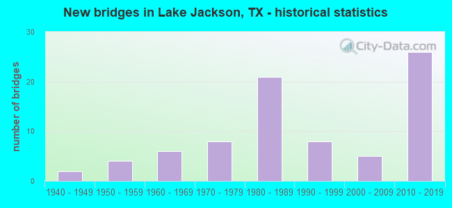
- New bridges - historical statistics
- 21940-1949
- 41950-1959
- 61960-1969
- 81970-1979
- 211980-1989
- 81990-1999
- 52000-2009
- 262010-2019
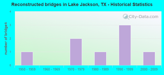
- Reconstructed bridges - Historical Statistics
- 11950-1959
- 01960-1969
- 21970-1979
- 11980-1989
- 31990-1999
- 12000-2009

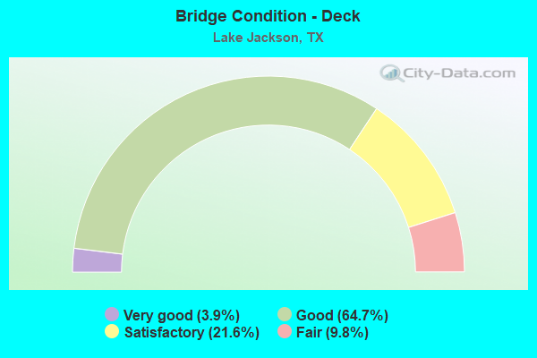
- Bridge Condition - Deck
- 3.9%Very good
- 64.7%Good
- 21.6%Satisfactory
- 9.8%Fair
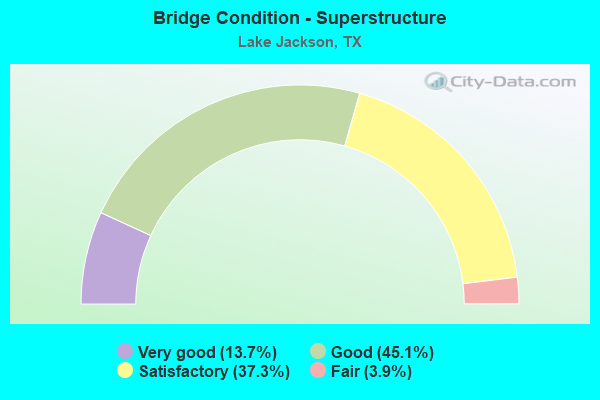
- Bridge Condition - Superstructure
- 13.7%Very good
- 45.1%Good
- 37.3%Satisfactory
- 3.9%Fair
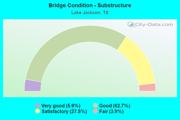
- Bridge Condition - Substructure
- 5.9%Very good
- 62.7%Good
- 27.5%Satisfactory
- 3.9%Fair
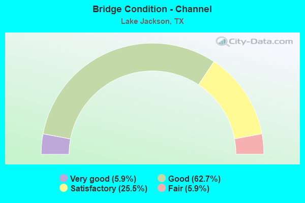
- Bridge Condition - Channel
- 5.9%Very good
- 62.7%Good
- 25.5%Satisfactory
- 5.9%Fair
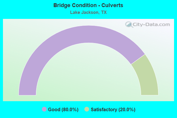
- Bridge Condition - Culverts
- 80.0%Good
- 20.0%Satisfactory
Find on map >> Show street view
Structure Number: 120200011107033, Location: 2.25 MI N OF FM 2004 (Lat: 29.106619, Lng: -95.418994), Route carried "on" structure: Business State highway 288, Year Built: 1943, Year Reconstructed: 1989, Status: Open, Structure Length: 1.19m (3.90ft), Average Daily Traffic: 10,080 (year 2013), Truck Traffic: 12%, Average Future Daily Traffic: 14,120 (year 2033), Design Load: H 15, Features Intersected: DRAINAGE DITCH
Minimum Vertical Clearance: 30+ m (98+ ft), Kilometerpoint: 6.621, Lanes on structure: 4, Owner: State Highway Agency, Approaching Roadway Width: 21.9m (71.9ft), Skew: 20 degrees, Material/Design: Concrete, Design/Construction: Culvert, Number Of Spans In Main Unit: 7, Length of Maximum Span: 1.5m (4.9ft)
Condition: Channel: Good, Culverts: Good, Operating Rating: 39.9 metric tons, Method Used To Determine Operating Rating: Load Factor (LF), Inventory Rating: 23.6 metric tons, Method Used To Determine Inventory Rating: Load Factor (LF), Structural Evaluation: Somewhat better than minimum adequacy, Waterway Adequacy: Equal to present minimum criteria, Approach Roadway Alignment: Equal to present desirable criteria, Designated Inspection Frequency: Every 24 months, Inspection Date: October 2020
Find on map >> Show street view
Structure Number: 12020001110803, Location: 0.55 MI S OF SH 332 (Lat: 28.997289, Lng: -95.384822), Route carried "on" structure: State highway 288, Year Built: 1942, Year Reconstructed: 1963, Status: Open, Structure Length: 3.81m (12.50ft), Average Daily Traffic: 16,853 (year 2019), Truck Traffic: 10%, Average Future Daily Traffic: 17,180 (year 2033), Design Load: H 15, Features Intersected: FLAG LAKE DRAINAGE CANAL
Minimum Vertical Clearance: 30+ m (98+ ft), Kilometerpoint: 11.919, Lanes on structure: 3, Owner: State Highway Agency, Approaching Roadway Width: 15.5m (50.9ft), Material/Design: Concrete continuous, Design/Construction: Slab, Number Of Spans In Main Unit: 3, Number Of Approach Spans: 2, Length of Maximum Span: 7.6m (24.9ft), Curb-To-Curb Width: 15.9m (52.2ft), Out-to-Out Width: 16.4m (53.8ft)
Condition: Deck: Good, Superstructure: Satisfactory, Substructure: Satisfactory, Channel: Fair, Operating Rating: 60.8 metric tons, Method Used To Determine Operating Rating: Load Factor (LF), Inventory Rating: 36.3 metric tons, Method Used To Determine Inventory Rating: Load Factor (LF), Structural Evaluation: Equal to present minimum criteria, Deck Geometry: Somewhat better than minimum adequacy, Waterway Adequacy: Equal to present minimum criteria, Approach Roadway Alignment: Equal to present desirable criteria, Length Of Structure Improvement: 4.66m (15.29ft), Designated Inspection Frequency: Every 24 months, Underwater Inspection Frequency: Every 60 months, Inspection Date: December 2020, Underwater Inspection Date: January 2019, Bridge Improvement Cost: $366,000, Roadway Improvement Cost: $92,000, Total Project Cost: $458,000, Deck Structure Type: Concrete Cast-file-Place, Wearing Surface/Protective System: Wearing Surface: Bituminous
Find on map >> Show street view
Structure Number: 120200011108043, Location: 0.55 MI S OF SH 332 (Lat: 28.997381, Lng: -95.384633), Route carried "on" structure: State highway 288, Year Built: 1957, Year Reconstructed: 1970, Status: Open, Structure Length: 3.84m (12.60ft), Average Daily Traffic: 14,998 (year 2019), Truck Traffic: 10%, Average Future Daily Traffic: 17,180 (year 2033), Design Load: H 20, Features Intersected: FLAG LAKE DRAINAGE CANAL
Minimum Vertical Clearance: 30+ m (98+ ft), Kilometerpoint: 11.919, Lanes on structure: 3, Owner: State Highway Agency, Approaching Roadway Width: 14.6m (47.9ft), Material/Design: Concrete, Design/Construction: Slab, Number Of Spans In Main Unit: 5, Length of Maximum Span: 7.6m (24.9ft), Curb-To-Curb Width: 14.6m (47.9ft), Out-to-Out Width: 15.1m (49.5ft)
Condition: Deck: Satisfactory, Superstructure: Satisfactory, Substructure: Satisfactory, Channel: Fair, Operating Rating: 57.1 metric tons, Method Used To Determine Operating Rating: Load Factor (LF), Inventory Rating: 34.5 metric tons, Method Used To Determine Inventory Rating: Load Factor (LF), Structural Evaluation: Equal to present minimum criteria, Deck Geometry: Meets minimum limits, Waterway Adequacy: Equal to present minimum criteria, Approach Roadway Alignment: Equal to present desirable criteria, Length Of Structure Improvement: 3.84m (12.60ft), Designated Inspection Frequency: Every 24 months, Underwater Inspection Frequency: Every 60 months, Inspection Date: December 2020, Underwater Inspection Date: January 2019, Bridge Improvement Cost: $121,000, Roadway Improvement Cost: $30,000, Total Project Cost: $151,000, Deck Structure Type: Concrete Cast-file-Place, Wearing Surface/Protective System: Wearing Surface: Bituminous
Find on map >> Show street view
Structure Number: 120200011108054, Location: 0.55 MI S OF SH 332 (Lat: 28.997194, Lng: -95.384633), Route carried "on" structure: ServiceState highway 288, Year Built: 1970, Status: Open, Structure Length: 3.69m (12.11ft), Average Daily Traffic: 12,000 (year 2010), Truck Traffic: 13%, Average Future Daily Traffic: 16,800 (year 2028), Design Load: H 20, Features Intersected: FLAG LAKE DRAINAGE CANAL
Minimum Vertical Clearance: 30+ m (98+ ft), Kilometerpoint: 11.919, Lanes on structure: 2, Owner: State Highway Agency, Approaching Roadway Width: 11.0m (36.1ft), Material/Design: Concrete, Design/Construction: Stringer/Multi-beam, Number Of Spans In Main Unit: 4, Length of Maximum Span: 9.1m (29.9ft), Curb-To-Curb Width: 11.0m (36.1ft), Out-to-Out Width: 11.5m (37.7ft)
Condition: Deck: Good, Superstructure: Satisfactory, Substructure: Good, Channel: Satisfactory, Operating Rating: 58.0 metric tons, Method Used To Determine Operating Rating: Load Factor (LF), Inventory Rating: 35.4 metric tons, Method Used To Determine Inventory Rating: Load Factor (LF), Structural Evaluation: Equal to present minimum criteria, Deck Geometry: Meets minimum limits, Waterway Adequacy: Equal to present minimum criteria, Approach Roadway Alignment: Equal to present desirable criteria, Designated Inspection Frequency: Every 24 months, Underwater Inspection Frequency: Every 60 months, Inspection Date: December 2020, Underwater Inspection Date: January 2019, Deck Structure Type: Concrete Cast-file-Place
Find on map >> Show street view
Structure Number: 120200011108055, Location: 0.55 MI S OF SH 332 (Lat: 28.997531, Lng: -95.384542), Route carried "on" structure: ServiceState highway 288, Year Built: 1970, Status: Open, Structure Length: 3.69m (12.11ft), Average Daily Traffic: 12,000 (year 2010), Truck Traffic: 13%, Average Future Daily Traffic: 16,800 (year 2028), Design Load: H 20, Features Intersected: FLAG LAKE DRAINAGE CANAL
Minimum Vertical Clearance: 30+ m (98+ ft), Kilometerpoint: 11.919, Lanes on structure: 2, Owner: State Highway Agency, Approaching Roadway Width: 11.0m (36.1ft), Material/Design: Concrete, Design/Construction: Stringer/Multi-beam, Number Of Spans In Main Unit: 4, Length of Maximum Span: 9.1m (29.9ft), Curb-To-Curb Width: 11.0m (36.1ft), Out-to-Out Width: 11.5m (37.7ft)
Condition: Deck: Good, Superstructure: Good, Substructure: Satisfactory, Channel: Satisfactory, Operating Rating: 58.0 metric tons, Method Used To Determine Operating Rating: Load Factor (LF), Inventory Rating: 35.4 metric tons, Method Used To Determine Inventory Rating: Load Factor (LF), Structural Evaluation: Equal to present minimum criteria, Deck Geometry: Meets minimum limits, Waterway Adequacy: Equal to present minimum criteria, Approach Roadway Alignment: Equal to present desirable criteria, Designated Inspection Frequency: Every 24 months, Underwater Inspection Frequency: Every 60 months, Inspection Date: December 2020, Underwater Inspection Date: January 2019, Deck Structure Type: Concrete Cast-file-Place
Find on map >> Show street view
Structure Number: 120200011108067, Location: 1.60 MI S OF SH 332 (Lat: 28.983803, Lng: -95.377769), Route carried "on" structure: State highway 288, Year Built: 1991, Status: Open, Structure Length: 4.75m (15.58ft), Average Daily Traffic: 10,810 (year 2020), Truck Traffic: 8%, Average Future Daily Traffic: 22,720 (year 2033), Design Load: HS 20, Features Intersected: DOW WASTE WATER CANAL
Minimum Vertical Clearance: 30+ m (98+ ft), Kilometerpoint: 13.593, Lanes on structure: 3, Owner: State Highway Agency, Approaching Roadway Width: 15.2m (49.9ft), Material/Design: Prestressed concrete, Design/Construction: Box Beam or Girders - Multiple, Number Of Spans In Main Unit: 3, Length of Maximum Span: 15.9m (52.2ft), Curb-To-Curb Width: 15.3m (50.2ft), Out-to-Out Width: 16.1m (52.8ft)
Condition: Deck: Good, Superstructure: Satisfactory, Substructure: Good, Channel: Satisfactory, Operating Rating: 54.4 metric tons, Method Used To Determine Operating Rating: Assigned rating based on Load Factor Design (LFD) reported in metric tons, Inventory Rating: 32.7 metric tons, Method Used To Determine Inventory Rating: Assigned rating based on Load Factor Design (LFD) reported in metric tons, Structural Evaluation: Equal to present minimum criteria, Deck Geometry: Meets minimum limits, Waterway Adequacy: Equal to present minimum criteria, Approach Roadway Alignment: Equal to present desirable criteria, Length Of Structure Improvement: 4.75m (15.58ft), Designated Inspection Frequency: Every 24 months, Underwater Inspection Frequency: Every 60 months, Inspection Date: November 2020, Underwater Inspection Date: October 2019, Deck Structure Type: Concrete Cast-file-Place
Find on map >> Show street view
Structure Number: 120200011108068, Location: 1.60 MI S OF SH 332 (Lat: 28.983883, Lng: -95.377386), Route carried "on" structure: State highway 288, Year Built: 1991, Status: Open, Structure Length: 4.75m (15.58ft), Average Daily Traffic: 10,764 (year 2020), Truck Traffic: 11%, Average Future Daily Traffic: 33,370 (year 2033), Design Load: HS 20, Features Intersected: DOW WASTE WATER CANAL
Minimum Vertical Clearance: 30+ m (98+ ft), Kilometerpoint: 13.593, Lanes on structure: 3, Owner: State Highway Agency, Approaching Roadway Width: 15.2m (49.9ft), Material/Design: Prestressed concrete, Design/Construction: Box Beam or Girders - Multiple, Number Of Spans In Main Unit: 3, Length of Maximum Span: 15.9m (52.2ft), Curb-To-Curb Width: 15.2m (49.9ft), Out-to-Out Width: 16.1m (52.8ft)
Condition: Deck: Satisfactory, Superstructure: Good, Substructure: Good, Channel: Satisfactory, Operating Rating: 54.4 metric tons, Method Used To Determine Operating Rating: Assigned rating based on Load Factor Design (LFD) reported in metric tons, Inventory Rating: 32.7 metric tons, Method Used To Determine Inventory Rating: Assigned rating based on Load Factor Design (LFD) reported in metric tons, Structural Evaluation: Better than present minimum criteria, Deck Geometry: Equal to present minimum criteria, Waterway Adequacy: Equal to present minimum criteria, Approach Roadway Alignment: Equal to present desirable criteria, Length Of Structure Improvement: 4.75m (15.58ft), Designated Inspection Frequency: Every 24 months, Underwater Inspection Frequency: Every 60 months, Inspection Date: November 2020, Underwater Inspection Date: October 2019, Deck Structure Type: Concrete Cast-file-Place
Find on map >> Show street view
Structure Number: 120200011108072, Location: 0.85 MI S. OF SH 332 (Lat: 28.992786, Lng: -95.382217), Route carried "on" structure: State highway 288, Year Built: 1998, Status: Open, Structure Length: 63.28m (207.61ft), Average Daily Traffic: 14,998 (year 2019), Truck Traffic: 10%, Average Future Daily Traffic: 17,180 (year 2033), Design Load: HS 20, Features Intersected: DOW BARGE CANAL
Minimum Vertical Clearance: 30+ m (98+ ft), Kilometerpoint: 12.328, Lanes on structure: 3, Owner: State Highway Agency, Approaching Roadway Width: 17.7m (58.1ft), Skew: 9 degrees, Material/Design: Prestressed concrete, Design/Construction: Stringer/Multi-beam, Number Of Spans In Main Unit: 20, Length of Maximum Span: 44.5m (146.0ft), Curb-To-Curb Width: 17.6m (57.7ft), Out-to-Out Width: 18.7m (61.4ft)
Condition: Deck: Good, Superstructure: Good, Substructure: Good, Channel: Very good, Operating Rating: 54.4 metric tons, Method Used To Determine Operating Rating: Assigned rating based on Load Factor Design (LFD) reported in metric tons, Inventory Rating: 32.7 metric tons, Method Used To Determine Inventory Rating: Assigned rating based on Load Factor Design (LFD) reported in metric tons, Structural Evaluation: Better than present minimum criteria, Deck Geometry: Better than present minimum criteria, Underclear: Somewhat better than minimum adequacy, Waterway Adequacy: Superior to present desirable criteria, Approach Roadway Alignment: Equal to present desirable criteria, Length Of Structure Improvement: 63.28m (207.61ft), Designated Inspection Frequency: Every 24 months, Underwater Inspection Frequency: Every 60 months, Inspection Date: December 2020, Underwater Inspection Date: August 2017, Bridge Improvement Cost: $880,000, Roadway Improvement Cost: $220,000, Total Project Cost: $1,100,000, Deck Structure Type: Concrete Precast Panels
Find on map >> Show street view
Structure Number: 120200011108075, Location: 0.85 MI S. OF SH 332 (Lat: 28.994533, Lng: -95.383586), Route carried "on" structure: State highway 288, Year Built: 1998, Status: Open, Structure Length: 63.28m (207.61ft), Average Daily Traffic: 16,853 (year 2019), Truck Traffic: 10%, Average Future Daily Traffic: 17,180 (year 2033), Design Load: HS 20, Features Intersected: DOW BARGE CANAL
Minimum Vertical Clearance: 30+ m (98+ ft), Kilometerpoint: 12.328, Lanes on structure: 4, Owner: State Highway Agency, Approaching Roadway Width: 21.0m (68.9ft), Skew: 9 degrees, Material/Design: Prestressed concrete, Design/Construction: Stringer/Multi-beam, Number Of Spans In Main Unit: 20, Length of Maximum Span: 44.5m (146.0ft), Curb-To-Curb Width: 21.2m (69.6ft), Out-to-Out Width: 22.3m (73.2ft)
Condition: Deck: Satisfactory, Superstructure: Good, Substructure: Good, Channel: Very good, Operating Rating: 54.4 metric tons, Method Used To Determine Operating Rating: Assigned rating based on Load Factor Design (LFD) reported in metric tons, Inventory Rating: 32.7 metric tons, Method Used To Determine Inventory Rating: Assigned rating based on Load Factor Design (LFD) reported in metric tons, Structural Evaluation: Better than present minimum criteria, Deck Geometry: Better than present minimum criteria, Underclear: Equal to present minimum criteria, Waterway Adequacy: Superior to present desirable criteria, Approach Roadway Alignment: Equal to present desirable criteria, Designated Inspection Frequency: Every 24 months, Underwater Inspection Frequency: Every 60 months, Inspection Date: December 2020, Underwater Inspection Date: August 2017, Deck Structure Type: Concrete Precast Panels
Find on map >> Show street view
Structure Number: 12020005860101, Location: 0.50 MI E OF SH 288 BUS (Lat: 29.003253, Lng: -95.382056), Route carried "on" structure: State highway 332, Year Built: 1986, Status: Open, Structure Length: 38.16m (125.20ft), Average Daily Traffic: 8,200 (year 2013), Truck Traffic: 11%, Average Future Daily Traffic: 11,480 (year 2033), Design Load: HS 20, Features Intersected: UP RR
Minimum Vertical Clearance: 30+ m (98+ ft), Kilometerpoint: 23.167, Lanes on structure: 2, Owner: State Highway Agency, Approaching Roadway Width: 12.2m (40.0ft), Material/Design: Prestressed concrete, Design/Construction: Stringer/Multi-beam, Number Of Spans In Main Unit: 5, Number Of Approach Spans: 11, Length of Maximum Span: 35.7m (117.1ft), Curb-To-Curb Width: 12.4m (40.7ft), Out-to-Out Width: 12.8m (42.0ft)
Condition: Deck: Good, Superstructure: Good, Substructure: Good, Operating Rating: 54.4 metric tons, Method Used To Determine Operating Rating: Assigned rating based on Load Factor Design (LFD) reported in metric tons, Inventory Rating: 32.7 metric tons, Method Used To Determine Inventory Rating: Assigned rating based on Load Factor Design (LFD) reported in metric tons, Structural Evaluation: Better than present minimum criteria, Deck Geometry: Better than present minimum criteria, Underclear: Meets minimum limits, Approach Roadway Alignment: Equal to present desirable criteria, Designated Inspection Frequency: Every 24 months, Inspection Date: November 2020, Deck Structure Type: Concrete Cast-file-Place
Find on map >> Show street view
Structure Number: 120200059804116, Location: 3.10 MI S OF SH 35 (Lat: 29.119078, Lng: -95.451631), Route carried "on" structure: State highway 288, Year Built: 1986, Status: Open, Structure Length: 3.66m (12.01ft), Average Daily Traffic: 18,783 (year 2020), Truck Traffic: 12%, Average Future Daily Traffic: 19,250 (year 2033), Design Load: HS 20, Features Intersected: DRAINAGE DITCH
Minimum Vertical Clearance: 30+ m (98+ ft), Kilometerpoint: 55.060, Lanes on structure: 2, Owner: State Highway Agency, Approaching Roadway Width: 12.8m (42.0ft), Material/Design: Concrete, Design/Construction: Stringer/Multi-beam, Number Of Spans In Main Unit: 3, Length of Maximum Span: 12.2m (40.0ft), Curb or Sidewalk Widths: Left: 0.0m, Right: 0.9m (3.0ft), Curb-To-Curb Width: 13.2m (43.3ft), Out-to-Out Width: 14.1m (46.3ft)
Condition: Deck: Satisfactory, Superstructure: Satisfactory, Substructure: Good, Channel: Good, Operating Rating: 54.4 metric tons, Method Used To Determine Operating Rating: Assigned rating based on Load Factor Design (LFD) reported in metric tons, Inventory Rating: 32.7 metric tons, Method Used To Determine Inventory Rating: Assigned rating based on Load Factor Design (LFD) reported in metric tons, Structural Evaluation: Equal to present minimum criteria, Deck Geometry: Superior to present desirable criteria, Waterway Adequacy: Superior to present desirable criteria, Approach Roadway Alignment: Equal to present desirable criteria, Designated Inspection Frequency: Every 24 months, Inspection Date: October 2020, Deck Structure Type: Concrete Cast-file-Place
Find on map >> Show street view
Structure Number: 120200059804117, Location: 3.10 MI S OF SH 35 (Lat: 29.119008, Lng: -95.451047), Route carried "on" structure: State highway 288, Year Built: 1986, Status: Open, Structure Length: 3.66m (12.01ft), Average Daily Traffic: 17,910 (year 2020), Truck Traffic: 12%, Average Future Daily Traffic: 19,250 (year 2033), Design Load: HS 20, Features Intersected: DRAINAGE DITCH
Minimum Vertical Clearance: 30+ m (98+ ft), Kilometerpoint: 55.060, Lanes on structure: 2, Owner: State Highway Agency, Approaching Roadway Width: 11.6m (38.1ft), Material/Design: Concrete, Design/Construction: Stringer/Multi-beam, Number Of Spans In Main Unit: 3, Length of Maximum Span: 12.2m (40.0ft), Curb-To-Curb Width: 11.4m (37.4ft), Out-to-Out Width: 12.3m (40.4ft)
Condition: Deck: Good, Superstructure: Good, Substructure: Good, Channel: Good, Operating Rating: 54.4 metric tons, Method Used To Determine Operating Rating: Assigned rating based on Load Factor Design (LFD) reported in metric tons, Inventory Rating: 32.7 metric tons, Method Used To Determine Inventory Rating: Assigned rating based on Load Factor Design (LFD) reported in metric tons, Structural Evaluation: Better than present minimum criteria, Deck Geometry: Somewhat better than minimum adequacy, Waterway Adequacy: Superior to present desirable criteria, Approach Roadway Alignment: Equal to present desirable criteria, Designated Inspection Frequency: Every 24 months, Inspection Date: October 2020, Deck Structure Type: Concrete Cast-file-Place
Find on map >> Show street view
Structure Number: 120200059804118, Location: 3.50 MI S OF SH 35 (Lat: 29.106214, Lng: -95.452556), Route carried "on" structure: State highway 288, Year Built: 1986, Status: Open, Structure Length: 13.99m (45.90ft), Average Daily Traffic: 18,783 (year 2020), Truck Traffic: 12%, Average Future Daily Traffic: 19,250 (year 2033), Design Load: HS 20, Features Intersected: BRANCH OF BASTROP BAYOU
Minimum Vertical Clearance: 30+ m (98+ ft), Kilometerpoint: 55.833, Lanes on structure: 2, Owner: State Highway Agency, Approaching Roadway Width: 11.6m (38.1ft), Skew: 2 degrees, Material/Design: Concrete, Design/Construction: Stringer/Multi-beam, Number Of Spans In Main Unit: 11, Length of Maximum Span: 12.5m (41.0ft), Curb-To-Curb Width: 11.4m (37.4ft), Out-to-Out Width: 12.3m (40.4ft)
Condition: Deck: Fair, Superstructure: Fair, Substructure: Fair, Channel: Good, Operating Rating: 54.4 metric tons, Method Used To Determine Operating Rating: Assigned rating based on Load Factor Design (LFD) reported in metric tons, Inventory Rating: 32.7 metric tons, Method Used To Determine Inventory Rating: Assigned rating based on Load Factor Design (LFD) reported in metric tons, Structural Evaluation: Somewhat better than minimum adequacy, Deck Geometry: Somewhat better than minimum adequacy, Waterway Adequacy: Superior to present desirable criteria, Approach Roadway Alignment: Equal to present desirable criteria, Designated Inspection Frequency: Every 24 months, Inspection Date: October 2020, Deck Structure Type: Concrete Cast-file-Place
Find on map >> Show street view
Structure Number: 120200059804119, Location: 3.50 MI S OF SH 35 (Lat: 29.110914, Lng: -95.451819), Route carried "on" structure: State highway 288, Year Built: 1986, Status: Open, Structure Length: 14.02m (46.00ft), Average Daily Traffic: 17,910 (year 2020), Truck Traffic: 12%, Average Future Daily Traffic: 19,250 (year 2033), Design Load: HS 20, Features Intersected: BRANCH OF BASTROP BAYOU
Minimum Vertical Clearance: 30+ m (98+ ft), Kilometerpoint: 55.833, Lanes on structure: 2, Owner: State Highway Agency, Approaching Roadway Width: 11.6m (38.1ft), Skew: 2 degrees, Material/Design: Concrete, Design/Construction: Stringer/Multi-beam, Number Of Spans In Main Unit: 11, Length of Maximum Span: 12.5m (41.0ft), Curb-To-Curb Width: 11.4m (37.4ft), Out-to-Out Width: 12.3m (40.4ft)
Condition: Deck: Satisfactory, Superstructure: Satisfactory, Substructure: Good, Channel: Good, Operating Rating: 54.4 metric tons, Method Used To Determine Operating Rating: Assigned rating based on Load Factor Design (LFD) reported in metric tons, Inventory Rating: 32.7 metric tons, Method Used To Determine Inventory Rating: Assigned rating based on Load Factor Design (LFD) reported in metric tons, Structural Evaluation: Equal to present minimum criteria, Deck Geometry: Somewhat better than minimum adequacy, Waterway Adequacy: Superior to present desirable criteria, Approach Roadway Alignment: Equal to present desirable criteria, Designated Inspection Frequency: Every 24 months, Inspection Date: October 2020, Deck Structure Type: Concrete Cast-file-Place
Find on map >> Show street view
Structure Number: 12020005980412, Location: 4.30 MI S OF SH 35 (Lat: 29.099628, Lng: -95.453389), Route carried "on" structure: State highway 288, Year Built: 1987, Status: Open, Structure Length: 3.90m (12.80ft), Average Daily Traffic: 18,783 (year 2020), Truck Traffic: 12%, Average Future Daily Traffic: 19,250 (year 2033), Design Load: HS 20, Features Intersected: BASTROP BAYOU RELIEF
Minimum Vertical Clearance: 30+ m (98+ ft), Kilometerpoint: 57.223, Lanes on structure: 2, Owner: State Highway Agency, Approaching Roadway Width: 11.6m (38.1ft), Skew: 3 degrees, Material/Design: Concrete, Design/Construction: Stringer/Multi-beam, Number Of Spans In Main Unit: 3, Length of Maximum Span: 12.8m (42.0ft), Curb-To-Curb Width: 11.4m (37.4ft), Out-to-Out Width: 12.3m (40.4ft)
Condition: Deck: Fair, Superstructure: Satisfactory, Substructure: Satisfactory, Channel: Good, Operating Rating: 54.4 metric tons, Method Used To Determine Operating Rating: Assigned rating based on Load Factor Design (LFD) reported in metric tons, Inventory Rating: 32.7 metric tons, Method Used To Determine Inventory Rating: Assigned rating based on Load Factor Design (LFD) reported in metric tons, Structural Evaluation: Equal to present minimum criteria, Deck Geometry: Somewhat better than minimum adequacy, Waterway Adequacy: Superior to present desirable criteria, Approach Roadway Alignment: Equal to present desirable criteria, Designated Inspection Frequency: Every 24 months, Inspection Date: October 2020, Deck Structure Type: Concrete Cast-file-Place
Find on map >> Show street view
Structure Number: 120200059804121, Location: 4.30 MI S OF SH 35 (Lat: 29.099097, Lng: -95.452836), Route carried "on" structure: State highway 288, Year Built: 1987, Status: Open, Structure Length: 3.90m (12.80ft), Average Daily Traffic: 17,910 (year 2020), Truck Traffic: 12%, Average Future Daily Traffic: 19,250 (year 2033), Design Load: HS 20, Features Intersected: BASTROP BAYOU RELIEF
Minimum Vertical Clearance: 30+ m (98+ ft), Kilometerpoint: 57.223, Lanes on structure: 2, Owner: State Highway Agency, Approaching Roadway Width: 11.6m (38.1ft), Skew: 3 degrees, Material/Design: Concrete, Design/Construction: Stringer/Multi-beam, Number Of Spans In Main Unit: 3, Length of Maximum Span: 12.8m (42.0ft), Curb-To-Curb Width: 11.4m (37.4ft), Out-to-Out Width: 12.3m (40.4ft)
Condition: Deck: Fair, Superstructure: Satisfactory, Substructure: Satisfactory, Channel: Good, Operating Rating: 54.4 metric tons, Method Used To Determine Operating Rating: Assigned rating based on Load Factor Design (LFD) reported in metric tons, Inventory Rating: 32.7 metric tons, Method Used To Determine Inventory Rating: Assigned rating based on Load Factor Design (LFD) reported in metric tons, Structural Evaluation: Equal to present minimum criteria, Deck Geometry: Somewhat better than minimum adequacy, Waterway Adequacy: Superior to present desirable criteria, Approach Roadway Alignment: Equal to present desirable criteria, Designated Inspection Frequency: Every 24 months, Inspection Date: October 2020, Deck Structure Type: Concrete Cast-file-Place
Find on map >> Show street view
Structure Number: 120200059804122, Location: 4.70 MI S OF SH 35 (Lat: 29.094947, Lng: -95.453250), Route carried "on" structure: State highway 288, Year Built: 1987, Status: Open, Structure Length: 19.51m (64.01ft), Average Daily Traffic: 18,783 (year 2020), Truck Traffic: 12%, Average Future Daily Traffic: 19,250 (year 2033), Design Load: HS 20, Features Intersected: BASTROP BAYOU
Minimum Vertical Clearance: 30+ m (98+ ft), Kilometerpoint: 56.762, Lanes on structure: 2, Owner: State Highway Agency, Approaching Roadway Width: 11.6m (38.1ft), Material/Design: Concrete, Design/Construction: Stringer/Multi-beam, Number Of Spans In Main Unit: 16, Length of Maximum Span: 12.2m (40.0ft), Curb-To-Curb Width: 11.3m (37.1ft), Out-to-Out Width: 12.2m (40.0ft)
Condition: Deck: Fair, Superstructure: Satisfactory, Substructure: Fair, Channel: Good, Operating Rating: 54.4 metric tons, Method Used To Determine Operating Rating: Assigned rating based on Load Factor Design (LFD) reported in metric tons, Inventory Rating: 32.7 metric tons, Method Used To Determine Inventory Rating: Assigned rating based on Load Factor Design (LFD) reported in metric tons, Structural Evaluation: Somewhat better than minimum adequacy, Deck Geometry: Somewhat better than minimum adequacy, Waterway Adequacy: Superior to present desirable criteria, Approach Roadway Alignment: Equal to present desirable criteria, Designated Inspection Frequency: Every 24 months, Inspection Date: October 2020, Deck Structure Type: Concrete Cast-file-Place
Find on map >> Show street view
Structure Number: 120200059804123, Location: 4.70 MI S OF SH 35 (Lat: 29.093344, Lng: -95.452639), Route carried "on" structure: State highway 288, Year Built: 1987, Status: Open, Structure Length: 19.51m (64.01ft), Average Daily Traffic: 17,910 (year 2020), Truck Traffic: 12%, Average Future Daily Traffic: 19,250 (year 2033), Design Load: HS 20, Features Intersected: BASTROP BAYOU
Minimum Vertical Clearance: 30+ m (98+ ft), Kilometerpoint: 56.762, Lanes on structure: 2, Owner: State Highway Agency, Approaching Roadway Width: 11.6m (38.1ft), Material/Design: Concrete, Design/Construction: Stringer/Multi-beam, Number Of Spans In Main Unit: 16, Length of Maximum Span: 12.2m (40.0ft), Curb-To-Curb Width: 11.4m (37.4ft), Out-to-Out Width: 12.3m (40.4ft)
Condition: Deck: Fair, Superstructure: Satisfactory, Substructure: Good, Channel: Good, Operating Rating: 54.4 metric tons, Method Used To Determine Operating Rating: Assigned rating based on Load Factor Design (LFD) reported in metric tons, Inventory Rating: 32.7 metric tons, Method Used To Determine Inventory Rating: Assigned rating based on Load Factor Design (LFD) reported in metric tons, Structural Evaluation: Equal to present minimum criteria, Deck Geometry: Somewhat better than minimum adequacy, Waterway Adequacy: Superior to present desirable criteria, Approach Roadway Alignment: Equal to present desirable criteria, Designated Inspection Frequency: Every 24 months, Inspection Date: October 2020, Deck Structure Type: Concrete Cast-file-Place
Find on map >> Show street view
Structure Number: 120200059804179, Location: 1.50 MI N OF FM 2004 (Lat: 29.080594, Lng: -95.452217), Route carried "on" structure: State highway 288, Year Built: 1985, Status: Open, Structure Length: 3.20m (10.50ft), Average Daily Traffic: 17,910 (year 2020), Truck Traffic: 12%, Average Future Daily Traffic: 19,250 (year 2033), Design Load: HS 20, Features Intersected: OUTFALL CHANNEL
Minimum Vertical Clearance: 30+ m (98+ ft), Kilometerpoint: 59.299, Lanes on structure: 2, Owner: State Highway Agency, Approaching Roadway Width: 11.6m (38.1ft), Material/Design: Prestressed concrete, Design/Construction: Box Beam or Girders - Multiple, Number Of Spans In Main Unit: 3, Length of Maximum Span: 10.7m (35.1ft), Curb-To-Curb Width: 11.8m (38.7ft), Out-to-Out Width: 16.0m (52.5ft)
Condition: Deck: Good, Superstructure: Very good, Substructure: Good, Channel: Good, Operating Rating: 54.4 metric tons, Method Used To Determine Operating Rating: Assigned rating based on Load Factor Design (LFD) reported in metric tons, Inventory Rating: 32.7 metric tons, Method Used To Determine Inventory Rating: Assigned rating based on Load Factor Design (LFD) reported in metric tons, Structural Evaluation: Better than present minimum criteria, Deck Geometry: Equal to present minimum criteria, Waterway Adequacy: Superior to present desirable criteria, Approach Roadway Alignment: Equal to present desirable criteria, Designated Inspection Frequency: Every 24 months, Inspection Date: October 2020, Deck Structure Type: Concrete Cast-file-Place
Find on map >> Show street view
Structure Number: 12020005980418, Location: 1.50 MI N OF FM 2004 (Lat: 29.080914, Lng: -95.452786), Route carried "on" structure: State highway 288, Year Built: 1985, Status: Open, Structure Length: 3.20m (10.50ft), Average Daily Traffic: 18,783 (year 2020), Truck Traffic: 12%, Average Future Daily Traffic: 19,250 (year 2033), Design Load: HS 20, Features Intersected: OUTFALL CHANNEL
Minimum Vertical Clearance: 30+ m (98+ ft), Kilometerpoint: 59.299, Lanes on structure: 2, Owner: State Highway Agency, Approaching Roadway Width: 11.6m (38.1ft), Material/Design: Prestressed concrete, Design/Construction: Box Beam or Girders - Multiple, Number Of Spans In Main Unit: 3, Length of Maximum Span: 10.7m (35.1ft), Curb-To-Curb Width: 12.0m (39.4ft), Out-to-Out Width: 17.8m (58.4ft)
Condition: Deck: Good, Superstructure: Very good, Substructure: Good, Channel: Good, Operating Rating: 54.4 metric tons, Method Used To Determine Operating Rating: Assigned rating based on Load Factor Design (LFD) reported in metric tons, Inventory Rating: 32.7 metric tons, Method Used To Determine Inventory Rating: Assigned rating based on Load Factor Design (LFD) reported in metric tons, Structural Evaluation: Better than present minimum criteria, Deck Geometry: Equal to present minimum criteria, Waterway Adequacy: Superior to present desirable criteria, Approach Roadway Alignment: Equal to present desirable criteria, Designated Inspection Frequency: Every 24 months, Inspection Date: October 2020, Deck Structure Type: Concrete Cast-file-Place
Find on map >> Show street view
Structure Number: 120200059804181, Location: 0.95 MI N OF FM 2004 (Lat: 29.073289, Lng: -95.451969), Route carried "on" structure: State highway 288, Year Built: 1985, Status: Open, Structure Length: 1.68m (5.51ft), Average Daily Traffic: 17,910 (year 2020), Truck Traffic: 12%, Average Future Daily Traffic: 19,250 (year 2033), Design Load: HS 20, Features Intersected: FLOOD RELIEF CHANNEL
Minimum Vertical Clearance: 30+ m (98+ ft), Kilometerpoint: 60.130, Lanes on structure: 2, Owner: State Highway Agency, Approaching Roadway Width: 11.6m (38.1ft), Material/Design: Prestressed concrete, Design/Construction: Box Beam or Girders - Multiple, Number Of Spans In Main Unit: 1, Length of Maximum Span: 16.8m (55.1ft), Curb-To-Curb Width: 11.3m (37.1ft), Out-to-Out Width: 12.2m (40.0ft)
Condition: Deck: Good, Superstructure: Very good, Substructure: Good, Channel: Good, Operating Rating: 54.4 metric tons, Method Used To Determine Operating Rating: Assigned rating based on Load Factor Design (LFD) reported in metric tons, Inventory Rating: 32.7 metric tons, Method Used To Determine Inventory Rating: Assigned rating based on Load Factor Design (LFD) reported in metric tons, Structural Evaluation: Better than present minimum criteria, Deck Geometry: Somewhat better than minimum adequacy, Waterway Adequacy: Superior to present desirable criteria, Approach Roadway Alignment: Equal to present desirable criteria, Designated Inspection Frequency: Every 24 months, Inspection Date: October 2020, Deck Structure Type: Concrete Cast-file-Place
Find on map >> Show street view
Structure Number: 120200059804182, Location: 0.95 MI N OF FM 2004 (Lat: 29.073400, Lng: -95.452550), Route carried "on" structure: State highway 288, Year Built: 1985, Status: Open, Structure Length: 1.68m (5.51ft), Average Daily Traffic: 18,783 (year 2020), Truck Traffic: 12%, Average Future Daily Traffic: 19,250 (year 2033), Design Load: HS 20, Features Intersected: FLOOD RELIEF CHANNEL
Minimum Vertical Clearance: 30+ m (98+ ft), Kilometerpoint: 60.130, Lanes on structure: 2, Owner: State Highway Agency, Approaching Roadway Width: 11.6m (38.1ft), Material/Design: Prestressed concrete, Design/Construction: Box Beam or Girders - Multiple, Number Of Spans In Main Unit: 1, Length of Maximum Span: 16.8m (55.1ft), Curb-To-Curb Width: 11.3m (37.1ft), Out-to-Out Width: 12.2m (40.0ft)
Condition: Deck: Good, Superstructure: Very good, Substructure: Good, Channel: Good, Operating Rating: 54.4 metric tons, Method Used To Determine Operating Rating: Assigned rating based on Load Factor Design (LFD) reported in metric tons, Inventory Rating: 32.7 metric tons, Method Used To Determine Inventory Rating: Assigned rating based on Load Factor Design (LFD) reported in metric tons, Structural Evaluation: Better than present minimum criteria, Deck Geometry: Somewhat better than minimum adequacy, Waterway Adequacy: Superior to present desirable criteria, Approach Roadway Alignment: Equal to present desirable criteria, Designated Inspection Frequency: Every 24 months, Inspection Date: October 2020, Deck Structure Type: Concrete Cast-file-Place
Find on map >> Show street view
Structure Number: 120200059804191, Location: 0.50 MI N OF SH 332 (Lat: 29.055181, Lng: -95.455503), Route carried "on" structure: State highway 288, Year Built: 1989, Status: Open, Structure Length: 18.01m (59.09ft), Average Daily Traffic: 17,910 (year 2020), Truck Traffic: 12%, Average Future Daily Traffic: 19,250 (year 2033), Design Load: HS 20, Features Intersected: OYSTER CREEK
Minimum Vertical Clearance: 30+ m (98+ ft), Kilometerpoint: 62.116, Lanes on structure: 3, Owner: State Highway Agency, Approaching Roadway Width: 13.4m (44.0ft), Skew: 9 degrees, Material/Design: Prestressed concrete, Design/Construction: Stringer/Multi-beam, Number Of Spans In Main Unit: 3, Number Of Approach Spans: 4, Length of Maximum Span: 36.6m (120.1ft), Curb-To-Curb Width: 13.8m (45.3ft), Out-to-Out Width: 14.7m (48.2ft)
Condition: Deck: Good, Superstructure: Good, Substructure: Good, Channel: Satisfactory, Operating Rating: 54.4 metric tons, Method Used To Determine Operating Rating: Assigned rating based on Load Factor Design (LFD) reported in metric tons, Inventory Rating: 32.7 metric tons, Method Used To Determine Inventory Rating: Assigned rating based on Load Factor Design (LFD) reported in metric tons, Structural Evaluation: Better than present minimum criteria, Deck Geometry: Meets minimum limits, Waterway Adequacy: Superior to present desirable criteria, Approach Roadway Alignment: Equal to present desirable criteria, Designated Inspection Frequency: Every 24 months, Inspection Date: October 2020, Deck Structure Type: Concrete Cast-file-Place
Find on map >> Show street view
Structure Number: 120200059804192, Location: 0.50 MI N OF SH 332 (Lat: 29.055175, Lng: -95.455853), Route carried "on" structure: State highway 288, Year Built: 1989, Status: Open, Structure Length: 18.26m (59.91ft), Average Daily Traffic: 18,783 (year 2020), Truck Traffic: 12%, Average Future Daily Traffic: 19,250 (year 2033), Design Load: HS 20, Features Intersected: OYSTER CREEK
Minimum Vertical Clearance: 30+ m (98+ ft), Kilometerpoint: 62.116, Lanes on structure: 3, Owner: State Highway Agency, Approaching Roadway Width: 14.0m (45.9ft), Skew: 9 degrees, Material/Design: Prestressed concrete, Design/Construction: Stringer/Multi-beam, Number Of Spans In Main Unit: 4, Number Of Approach Spans: 3, Length of Maximum Span: 38.1m (125.0ft), Curb-To-Curb Width: 13.8m (45.3ft), Out-to-Out Width: 14.7m (48.2ft)
Condition: Deck: Good, Superstructure: Good, Substructure: Good, Channel: Satisfactory, Operating Rating: 54.4 metric tons, Method Used To Determine Operating Rating: Assigned rating based on Load Factor Design (LFD) reported in metric tons, Inventory Rating: 32.7 metric tons, Method Used To Determine Inventory Rating: Assigned rating based on Load Factor Design (LFD) reported in metric tons, Structural Evaluation: Better than present minimum criteria, Deck Geometry: Meets minimum limits, Waterway Adequacy: Superior to present desirable criteria, Approach Roadway Alignment: Equal to present desirable criteria, Designated Inspection Frequency: Every 24 months, Inspection Date: October 2020, Deck Structure Type: Concrete Cast-file-Place
Find on map >> Show street view
Structure Number: 120200059804237, Location: 0.55 MI S OF OYSTER CREEK (Lat: 29.047011, Lng: -95.454883), Route carried "on" structure: State highway 288, Year Built: 1998, Status: Open, Structure Length: 13.26m (43.50ft), Average Daily Traffic: 11,681 (year 2020), Truck Traffic: 12%, Average Future Daily Traffic: 19,250 (year 2033), Design Load: HS 20, Features Intersected: SH 332 (OYSTER CREEK DR)
Minimum Vertical Clearance: 30+ m (98+ ft), Kilometerpoint: 63.062, Lanes on structure: 2, Lanes under structure: 8, Owner: State Highway Agency, Approaching Roadway Width: 11.6m (38.1ft), Skew: 2 degrees, Material/Design: Prestressed concrete, Design/Construction: Stringer/Multi-beam, Number Of Spans In Main Unit: 4, Length of Maximum Span: 35.1m (115.2ft), Curb-To-Curb Width: 11.6m (38.1ft), Out-to-Out Width: 12.4m (40.7ft)
Condition: Deck: Good, Superstructure: Good, Substructure: Good, Operating Rating: 54.4 metric tons, Method Used To Determine Operating Rating: Assigned rating based on Load Factor Design (LFD) reported in metric tons, Inventory Rating: 32.7 metric tons, Method Used To Determine Inventory Rating: Assigned rating based on Load Factor Design (LFD) reported in metric tons, Structural Evaluation: Better than present minimum criteria, Deck Geometry: Equal to present minimum criteria, Underclear: Meets minimum limits, Approach Roadway Alignment: Equal to present desirable criteria, Designated Inspection Frequency: Every 24 months, Inspection Date: November 2020, Deck Structure Type: Concrete Precast Panels
Find on map >> Show street view
Structure Number: 120200059804238, Location: 0.55 MI S OF OYSTER CREEK (Lat: 29.047211, Lng: -95.455256), Route carried "on" structure: State highway 288, Year Built: 1998, Status: Open, Structure Length: 16.00m (52.49ft), Average Daily Traffic: 12,339 (year 2020), Truck Traffic: 12%, Average Future Daily Traffic: 19,250 (year 2033), Design Load: HS 20, Features Intersected: OYSTER CREEK DR./SH-332
Minimum Vertical Clearance: 30+ m (98+ ft), Kilometerpoint: 63.054, Lanes on structure: 2, Lanes under structure: 8, Owner: State Highway Agency, Approaching Roadway Width: 11.6m (38.1ft), Skew: 2 degrees, Material/Design: Prestressed concrete, Design/Construction: Stringer/Multi-beam, Number Of Spans In Main Unit: 5, Length of Maximum Span: 35.1m (115.2ft), Curb-To-Curb Width: 11.6m (38.1ft), Out-to-Out Width: 12.4m (40.7ft)
Condition: Deck: Good, Superstructure: Good, Substructure: Good, Operating Rating: 54.4 metric tons, Method Used To Determine Operating Rating: Assigned rating based on Load Factor Design (LFD) reported in metric tons, Inventory Rating: 32.7 metric tons, Method Used To Determine Inventory Rating: Assigned rating based on Load Factor Design (LFD) reported in metric tons, Structural Evaluation: Better than present minimum criteria, Deck Geometry: Equal to present minimum criteria, Underclear: Meets minimum limits, Approach Roadway Alignment: Equal to present desirable criteria, Designated Inspection Frequency: Every 24 months, Inspection Date: November 2020, Deck Structure Type: Concrete Precast Panels
Find on map >> Show street view
Structure Number: 120200059804338, Location: 0.7 MI NORTH OF SH 332 (Lat: 29.061922, Lng: -95.453442), Route carried "on" structure: State highway 288, Year Built: 2004, Status: Open, Structure Length: 48.16m (158.01ft), Average Daily Traffic: 17,910 (year 2020), Truck Traffic: 12%, Average Future Daily Traffic: 19,250 (year 2033), Design Load: HS 20, Features Intersected: FM 2004
Minimum Vertical Clearance: 30+ m (98+ ft), Kilometerpoint: 61.417, Lanes on structure: 2, Lanes under structure: 5, Owner: State Highway Agency, Approaching Roadway Width: 11.6m (38.1ft), Material/Design: Steel continuous, Design/Construction: Stringer/Multi-beam, Number Of Spans In Main Unit: 3, Number Of Approach Spans: 9, Length of Maximum Span: 65.8m (215.9ft), Curb-To-Curb Width: 11.6m (38.1ft), Out-to-Out Width: 12.4m (40.7ft)
Condition: Deck: Good, Superstructure: Good, Substructure: Good, Operating Rating: 54.4 metric tons, Method Used To Determine Operating Rating: Assigned rating based on Load Factor Design (LFD) reported in metric tons, Inventory Rating: 32.7 metric tons, Method Used To Determine Inventory Rating: Assigned rating based on Load Factor Design (LFD) reported in metric tons, Structural Evaluation: Better than present minimum criteria, Deck Geometry: Equal to present minimum criteria, Underclear: Meets minimum limits, Approach Roadway Alignment: Equal to present desirable criteria, Designated Inspection Frequency: Every 24 months, Inspection Date: November 2020, Deck Structure Type: Concrete Cast-file-Place
Find on map >> Show street view
Structure Number: 120200059804339, Location: 0.7 MI NORTH OF SH 332 (Lat: 29.061878, Lng: -95.453483), Route carried "on" structure: State highway 288, Year Built: 2004, Status: Open, Structure Length: 48.16m (158.01ft), Average Daily Traffic: 18,783 (year 2020), Truck Traffic: 12%, Average Future Daily Traffic: 19,250 (year 2033), Design Load: HS 20, Features Intersected: FM 2004
Minimum Vertical Clearance: 30+ m (98+ ft), Kilometerpoint: 61.417, Lanes on structure: 2, Lanes under structure: 5, Owner: State Highway Agency, Approaching Roadway Width: 11.6m (38.1ft), Material/Design: Steel continuous, Design/Construction: Stringer/Multi-beam, Number Of Spans In Main Unit: 3, Number Of Approach Spans: 9, Length of Maximum Span: 65.8m (215.9ft), Curb-To-Curb Width: 11.6m (38.1ft), Out-to-Out Width: 12.4m (40.7ft)
Condition: Deck: Good, Superstructure: Good, Substructure: Good, Operating Rating: 54.4 metric tons, Method Used To Determine Operating Rating: Assigned rating based on Load Factor Design (LFD) reported in metric tons, Inventory Rating: 32.7 metric tons, Method Used To Determine Inventory Rating: Assigned rating based on Load Factor Design (LFD) reported in metric tons, Structural Evaluation: Better than present minimum criteria, Deck Geometry: Equal to present minimum criteria, Underclear: Meets minimum limits, Approach Roadway Alignment: Equal to present desirable criteria, Designated Inspection Frequency: Every 24 months, Inspection Date: November 2020, Deck Structure Type: Concrete Cast-file-Place
Find on map >> Show street view
Structure Number: 120200059804343, Location: 0.2 MI SOUTH OF CR 220 (Lat: 29.123156, Lng: -95.452358), Route carried "on" structure: State highway 288, Year Built: 2004, Status: Open, Structure Length: 2.83m (9.28ft), Average Daily Traffic: 6,680 (year 2010), Truck Traffic: 17%, Average Future Daily Traffic: 12,470 (year 2030), Design Load: HS 20, Features Intersected: E TRIB BASTROP BAYOU
Minimum Vertical Clearance: 30+ m (98+ ft), Kilometerpoint: 0.002, Lanes on structure: 1, Owner: State Highway Agency, Approaching Roadway Width: 7.3m (24.0ft), Skew: 6 degrees, Material/Design: Concrete, Design/Construction: Culvert, Number Of Spans In Main Unit: 4, Length of Maximum Span: 2.4m (7.9ft)
Condition: Channel: Good, Culverts: Satisfactory, Operating Rating: 54.4 metric tons, Method Used To Determine Operating Rating: Assigned rating based on Load Factor Design (LFD) reported in metric tons, Inventory Rating: 32.7 metric tons, Method Used To Determine Inventory Rating: Assigned rating based on Load Factor Design (LFD) reported in metric tons, Structural Evaluation: Equal to present minimum criteria, Waterway Adequacy: Equal to present minimum criteria, Approach Roadway Alignment: Equal to present desirable criteria, Designated Inspection Frequency: Every 48 months, Inspection Date: September 2020
Find on map >> Show street view
Structure Number: 120200152401004, Location: 0.40 MI W OF FM 2004 (Lat: 29.049297, Lng: -95.477181), Route carried "on" structure: State highway 332, Year Built: 1961, Year Reconstructed: 1998, Status: Open, Structure Length: 7.41m (24.31ft), Average Daily Traffic: 11,311 (year 2020), Truck Traffic: 11%, Average Future Daily Traffic: 14,830 (year 2033), Features Intersected: BUFFALO CAMP BAYOU
Minimum Vertical Clearance: 30+ m (98+ ft), Kilometerpoint: 10.263, Lanes on structure: 2, Owner: State Highway Agency, Approaching Roadway Width: 11.9m (39.0ft), Material/Design: Concrete, Design/Construction: Stringer/Multi-beam, Number Of Spans In Main Unit: 8, Length of Maximum Span: 9.1m (29.9ft), Curb-To-Curb Width: 12.0m (39.4ft), Out-to-Out Width: 13.2m (43.3ft)
Condition: Deck: Good, Superstructure: Good, Substructure: Satisfactory, Channel: Satisfactory, Operating Rating: 68.0 metric tons, Method Used To Determine Operating Rating: Load Factor (LF), Inventory Rating: 40.8 metric tons, Method Used To Determine Inventory Rating: Load Factor (LF), Structural Evaluation: Equal to present minimum criteria, Deck Geometry: Somewhat better than minimum adequacy, Waterway Adequacy: Equal to present minimum criteria, Approach Roadway Alignment: Equal to present desirable criteria, Length Of Structure Improvement: 7.41m (24.31ft), Designated Inspection Frequency: Every 24 months, Underwater Inspection Frequency: Every 60 months, Inspection Date: November 2020, Underwater Inspection Date: January 2017, Bridge Improvement Cost: $134,000, Roadway Improvement Cost: $34,000, Total Project Cost: $168,000, Deck Structure Type: Concrete Cast-file-Place
Find on map >> Show street view
Structure Number: 120200152401005, Location: 0.15 MI W OF FM 2004 (Lat: 29.048444, Lng: -95.473339), Route carried "on" structure: State highway 332, Year Built: 1961, Year Reconstructed: 1999, Status: Open, Structure Length: 3.69m (12.11ft), Average Daily Traffic: 11,311 (year 2020), Truck Traffic: 11%, Average Future Daily Traffic: 14,830 (year 2033), Features Intersected: DOW FRESH WATER CANAL
Minimum Vertical Clearance: 30+ m (98+ ft), Kilometerpoint: 10.691, Lanes on structure: 2, Owner: State Highway Agency, Approaching Roadway Width: 11.9m (39.0ft), Material/Design: Concrete, Design/Construction: Stringer/Multi-beam, Number Of Spans In Main Unit: 4, Length of Maximum Span: 9.1m (29.9ft), Curb-To-Curb Width: 12.2m (40.0ft), Out-to-Out Width: 13.2m (43.3ft)
Condition: Deck: Good, Superstructure: Satisfactory, Substructure: Satisfactory, Channel: Satisfactory, Operating Rating: 68.0 metric tons, Method Used To Determine Operating Rating: Load Factor (LF), Inventory Rating: 40.8 metric tons, Method Used To Determine Inventory Rating: Load Factor (LF), Structural Evaluation: Equal to present minimum criteria, Deck Geometry: Somewhat better than minimum adequacy, Waterway Adequacy: Equal to present minimum criteria, Approach Roadway Alignment: Equal to present desirable criteria, Length Of Structure Improvement: 3.69m (12.11ft), Designated Inspection Frequency: Every 24 months, Inspection Date: November 2020, Bridge Improvement Cost: $67,000, Roadway Improvement Cost: $17,000, Total Project Cost: $84,000, Deck Structure Type: Concrete Cast-file-Place
Find on map >> Show street view
Structure Number: 120200152401058, Location: 0.20 MI E OF SH 288 (Lat: 29.004686, Lng: -95.389189), Route carried "on" structure: State highway 332, Year Built: 1972, Status: Open, Structure Length: 10.36m (33.99ft), Average Daily Traffic: 12,500 (year 2013), Truck Traffic: 9%, Average Future Daily Traffic: 24,670 (year 2030), Design Load: HS 20, Features Intersected: SH 288 BUS
Minimum Vertical Clearance: 30+ m (98+ ft), Kilometerpoint: 21.163, Lanes on structure: 3, Lanes under structure: 6, Owner: State Highway Agency, Approaching Roadway Width: 16.5m (54.1ft), Skew: 2 degrees, Material/Design: Prestressed concrete, Design/Construction: Stringer/Multi-beam, Number Of Spans In Main Unit: 4, Length of Maximum Span: 29.0m (95.1ft), Curb-To-Curb Width: 16.5m (54.1ft), Out-to-Out Width: 17.0m (55.8ft)
Condition: Deck: Good, Superstructure: Satisfactory, Substructure: Satisfactory, Operating Rating: 54.4 metric tons, Method Used To Determine Operating Rating: Assigned rating based on Load Factor Design (LFD) reported in metric tons, Inventory Rating: 32.7 metric tons, Method Used To Determine Inventory Rating: Assigned rating based on Load Factor Design (LFD) reported in metric tons, Structural Evaluation: Equal to present minimum criteria, Deck Geometry: Equal to present minimum criteria, Underclear: Superior to present desirable criteria, Approach Roadway Alignment: Equal to present desirable criteria, Designated Inspection Frequency: Every 24 months, Inspection Date: November 2020, Deck Structure Type: Concrete Cast-file-Place
Find on map >> Show street view
Structure Number: 12020015240106, Location: 0.20 MI W OF SH 288 BUS (Lat: 29.004453, Lng: -95.392422), Route carried "on" structure: State highway 332, Year Built: 1970, Status: Open, Structure Length: 13.41m (44.00ft), Average Daily Traffic: 8,650 (year 2015), Truck Traffic: 3%, Average Future Daily Traffic: 17,300 (year 2035), Design Load: HS 20, Features Intersected: SH 288
Minimum Vertical Clearance: 30+ m (98+ ft), Kilometerpoint: 22.029, Lanes on structure: 2, Lanes under structure: 4, Owner: State Highway Agency, Approaching Roadway Width: 12.2m (40.0ft), Skew: 9 degrees, Material/Design: Prestressed concrete, Design/Construction: Stringer/Multi-beam, Number Of Spans In Main Unit: 3, Number Of Approach Spans: 1, Length of Maximum Span: 36.6m (120.1ft), Curb-To-Curb Width: 12.2m (40.0ft), Out-to-Out Width: 12.8m (42.0ft)
Condition: Deck: Satisfactory, Superstructure: Satisfactory, Substructure: Good, Operating Rating: 54.4 metric tons, Method Used To Determine Operating Rating: Assigned rating based on Load Factor Design (LFD) reported in metric tons, Inventory Rating: 32.7 metric tons, Method Used To Determine Inventory Rating: Assigned rating based on Load Factor Design (LFD) reported in metric tons, Structural Evaluation: Equal to present minimum criteria, Deck Geometry: Better than present minimum criteria, Underclear: Equal to present minimum criteria, Approach Roadway Alignment: Equal to present desirable criteria, Designated Inspection Frequency: Every 24 months, Inspection Date: December 2020, Deck Structure Type: Concrete Cast-file-Place
Find on map >> Show street view
Structure Number: 120200152401065, Location: 50 FT E OF OAK DR (Lat: 29.035433, Lng: -95.448914), Route carried "on" structure: State highway 332, Year Built: 2012, Status: Open, Structure Length: 0.79m (2.59ft), Average Daily Traffic: 6,500 (year 2015), Truck Traffic: 5%, Average Future Daily Traffic: 9,700 (year 2035), Design Load: HS 20, Features Intersected: DRAINAGE DITCH
Minimum Vertical Clearance: 30+ m (98+ ft), Kilometerpoint: 0.000, Lanes on structure: 8, Owner: State Highway Agency, Approaching Roadway Width: 43.0m (141.1ft), Material/Design: Concrete, Design/Construction: Culvert, Number Of Spans In Main Unit: 4, Length of Maximum Span: 1.5m (4.9ft), Curb or Sidewalk Widths: Left: 1.5m (4.9ft), Right: 1.5m (4.9ft), Curb-To-Curb Width: 43.0m (141.1ft), Out-to-Out Width: 84.1m (275.9ft)
Condition: Channel: Good, Culverts: Good, Operating Rating: 54.4 metric tons, Method Used To Determine Operating Rating: Assigned rating based on Load Factor Design (LFD) reported in metric tons, Inventory Rating: 32.7 metric tons, Method Used To Determine Inventory Rating: Assigned rating based on Load Factor Design (LFD) reported in metric tons, Structural Evaluation: Better than present minimum criteria, Deck Geometry: Superior to present desirable criteria, Waterway Adequacy: Superior to present desirable criteria, Approach Roadway Alignment: Equal to present desirable criteria, Designated Inspection Frequency: Every 48 months, Inspection Date: December 2020, Deck Structure Type: Other
Find on map >> Show street view
Structure Number: 120200152401066, Location: 0.11 NW OF MAGNOLIA ST (Lat: 29.025133, Lng: -95.436836), Route carried "on" structure: State highway 332, Year Built: 2012, Status: Open, Structure Length: 0.88m (2.89ft), Average Daily Traffic: 44,394 (year 2016), Truck Traffic: 8%, Average Future Daily Traffic: 42,970 (year 2030), Design Load: HS 20, Features Intersected: DRAINAGE DITCH
Minimum Vertical Clearance: 30+ m (98+ ft), Kilometerpoint: 0.000, Lanes on structure: 10, Owner: State Highway Agency, Approaching Roadway Width: 51.5m (169.0ft), Skew: 31 degrees, Material/Design: Concrete, Design/Construction: Culvert, Number Of Spans In Main Unit: 3, Length of Maximum Span: 2.4m (7.9ft), Curb or Sidewalk Widths: Left: 1.5m (4.9ft), Right: 1.5m (4.9ft), Curb-To-Curb Width: 51.5m (169.0ft), Out-to-Out Width: 79.9m (262.1ft)
Condition: Channel: Good, Culverts: Good, Operating Rating: 54.4 metric tons, Method Used To Determine Operating Rating: Assigned rating based on Load Factor Design (LFD) reported in metric tons, Inventory Rating: 32.7 metric tons, Method Used To Determine Inventory Rating: Assigned rating based on Load Factor Design (LFD) reported in metric tons, Structural Evaluation: Better than present minimum criteria, Deck Geometry: Superior to present desirable criteria, Waterway Adequacy: Superior to present desirable criteria, Approach Roadway Alignment: Equal to present desirable criteria, Designated Inspection Frequency: Every 48 months, Inspection Date: December 2020, Deck Structure Type: Other
Find on map >> Show street view
Structure Number: 120200152401067, Location: 0.1 MI SE OF FLAG DR (Lat: 29.014744, Lng: -95.431447), Route carried "on" structure: State highway 332, Year Built: 2012, Status: Open, Structure Length: 0.91m (2.99ft), Average Daily Traffic: 41,567 (year 2020), Truck Traffic: 11%, Average Future Daily Traffic: 48,400 (year 2035), Design Load: HS 20, Features Intersected: DRAINAGE DITCH
Minimum Vertical Clearance: 30+ m (98+ ft), Kilometerpoint: 0.000, Lanes on structure: 9, Owner: State Highway Agency, Approaching Roadway Width: 49.7m (163.1ft), Skew: 32 degrees, Material/Design: Concrete, Design/Construction: Culvert, Number Of Spans In Main Unit: 3, Length of Maximum Span: 2.4m (7.9ft), Curb or Sidewalk Widths: Left: 1.5m (4.9ft), Right: 1.5m (4.9ft), Curb-To-Curb Width: 49.7m (163.1ft), Out-to-Out Width: 80.5m (264.1ft)
Condition: Channel: Good, Culverts: Satisfactory, Operating Rating: 54.4 metric tons, Method Used To Determine Operating Rating: Assigned rating based on Load Factor Design (LFD) reported in metric tons, Inventory Rating: 32.7 metric tons, Method Used To Determine Inventory Rating: Assigned rating based on Load Factor Design (LFD) reported in metric tons, Structural Evaluation: Equal to present minimum criteria, Deck Geometry: Superior to present desirable criteria, Waterway Adequacy: Superior to present desirable criteria, Approach Roadway Alignment: Equal to present desirable criteria, Designated Inspection Frequency: Every 48 months, Inspection Date: December 2020, Deck Structure Type: Other
Find on map >> Show street view
Structure Number: 120200152401068, Location: 0.26 miles E OF S LAZY LN (Lat: 29.009533, Lng: -95.412722), Route carried "on" structure: State highway 332, Year Built: 2012, Status: Open, Structure Length: 0.98m (3.22ft), Average Daily Traffic: 41,567 (year 2020), Truck Traffic: 5%, Average Future Daily Traffic: 48,400 (year 2035), Design Load: HS 20, Features Intersected: DRAINAGE DITCH
Minimum Vertical Clearance: 30+ m (98+ ft), Kilometerpoint: 0.000, Lanes on structure: 10, Owner: State Highway Agency, Approaching Roadway Width: 48.2m (158.1ft), Skew: 39 degrees, Material/Design: Concrete, Design/Construction: Culvert, Number Of Spans In Main Unit: 3, Length of Maximum Span: 2.4m (7.9ft), Curb or Sidewalk Widths: Left: 1.5m (4.9ft), Right: 1.5m (4.9ft)
Condition: Channel: Good, Culverts: Good, Operating Rating: 54.4 metric tons, Method Used To Determine Operating Rating: Assigned rating based on Load Factor Design (LFD) reported in metric tons, Inventory Rating: 32.7 metric tons, Method Used To Determine Inventory Rating: Assigned rating based on Load Factor Design (LFD) reported in metric tons, Structural Evaluation: Better than present minimum criteria, Waterway Adequacy: Superior to present desirable criteria, Approach Roadway Alignment: Equal to present desirable criteria, Designated Inspection Frequency: Every 48 months, Inspection Date: December 2020
Find on map >> Show street view
Structure Number: 120200152401069, Location: 0.15 MI W OF S LAZY LN (Lat: 29.009467, Lng: -95.417208), Route carried "on" structure: State highway 332, Year Built: 2012, Status: Open, Structure Length: 0.76m (2.49ft), Average Daily Traffic: 41,567 (year 2020), Truck Traffic: 5%, Average Future Daily Traffic: 48,400 (year 2035), Design Load: HS 20, Features Intersected: DRAINAGE DITCH
Minimum Vertical Clearance: 30+ m (98+ ft), Kilometerpoint: 0.000, Lanes on structure: 10, Owner: State Highway Agency, Approaching Roadway Width: 48.2m (158.1ft), Skew: 30 degrees, Material/Design: Concrete, Design/Construction: Culvert, Number Of Spans In Main Unit: 3, Length of Maximum Span: 2.1m (6.9ft), Curb or Sidewalk Widths: Left: 1.5m (4.9ft), Right: 1.5m (4.9ft)
Condition: Channel: Good, Culverts: Good, Operating Rating: 54.4 metric tons, Method Used To Determine Operating Rating: Assigned rating based on Load Factor Design (LFD) reported in metric tons, Inventory Rating: 32.7 metric tons, Method Used To Determine Inventory Rating: Assigned rating based on Load Factor Design (LFD) reported in metric tons, Structural Evaluation: Better than present minimum criteria, Waterway Adequacy: Superior to present desirable criteria, Approach Roadway Alignment: Equal to present desirable criteria, Designated Inspection Frequency: Every 48 months, Inspection Date: December 2020
Find on map >> Show street view
Structure Number: 12020015240107, Location: 0.7 MI E OF DIXIE DR (Lat: 29.009578, Lng: -95.408711), Route carried "on" structure: State highway 332, Year Built: 2010, Status: Open, Structure Length: 1.43m (4.69ft), Average Daily Traffic: 41,567 (year 2020), Truck Traffic: 10%, Average Future Daily Traffic: 48,400 (year 2032), Design Load: HL 93, Features Intersected: DRAINAGE DITCH
Minimum Vertical Clearance: 30+ m (98+ ft), Kilometerpoint: 1.127, Lanes on structure: 10, Owner: State Highway Agency, Approaching Roadway Width: 55.8m (183.1ft), Skew: 10 degrees, Material/Design: Concrete, Design/Construction: Culvert, Number Of Spans In Main Unit: 4, Length of Maximum Span: 3.0m (9.8ft)
Condition: Channel: Satisfactory, Culverts: Good, Operating Rating: 45.4 metric tons, Method Used To Determine Operating Rating: Assigned ratings based on Load and Resistance Factor Design (LRFD) reported in metric tons, Inventory Rating: 32.7 metric tons, Method Used To Determine Inventory Rating: Assigned ratings based on Load and Resistance Factor Design (LRFD) reported in metric tons, Structural Evaluation: Better than present minimum criteria, Waterway Adequacy: Superior to present desirable criteria, Approach Roadway Alignment: Equal to present desirable criteria, Designated Inspection Frequency: Every 48 months, Inspection Date: December 2020
Find on map >> Show street view
Structure Number: 120200152401071, Location: 0.30 MI SE of JCT SH 288 (Lat: 29.038900, Lng: -95.452700), Route carried "on" structure: State highway 332, Year Built: 2012, Status: Open, Structure Length: 33.53m (110.01ft), Average Daily Traffic: 38,000 (year 2012), Truck Traffic: 16%, Average Future Daily Traffic: 42,970 (year 2030), Design Load: HL 93, Features Intersected: This Way St.
Minimum Vertical Clearance: 30+ m (98+ ft), Kilometerpoint: 13.604, Lanes on structure: 3, Lanes under structure: 7, Owner: State Highway Agency, Approaching Roadway Width: 17.1m (56.1ft), Material/Design: Prestressed concrete, Design/Construction: Stringer/Multi-beam, Number Of Spans In Main Unit: 11, Length of Maximum Span: 31.1m (102.0ft), Curb-To-Curb Width: 17.1m (56.1ft), Out-to-Out Width: 17.8m (58.4ft)
Condition: Deck: Good, Superstructure: Good, Substructure: Good, Operating Rating: 54.4 metric tons, Method Used To Determine Operating Rating: Assigned ratings based on Load and Resistance Factor Design (LRFD) reported in metric tons, Inventory Rating: 32.7 metric tons, Method Used To Determine Inventory Rating: Assigned ratings based on Load and Resistance Factor Design (LRFD) reported in metric tons, Structural Evaluation: Better than present minimum criteria, Deck Geometry: Equal to present minimum criteria, Underclear: Equal to present minimum criteria, Approach Roadway Alignment: Equal to present desirable criteria, Designated Inspection Frequency: Every 24 months, Inspection Date: December 2020, Deck Structure Type: Concrete Precast Panels
Find on map >> Show street view
Structure Number: 120200152401072, Location: 0.3 MI SE of Jct. SH 288 (Lat: 29.041450, Lng: -95.454400), Route carried "on" structure: State highway 332, Year Built: 2012, Status: Open, Structure Length: 34.56m (113.39ft), Average Daily Traffic: 30,690 (year 2010), Truck Traffic: 16%, Average Future Daily Traffic: 42,970 (year 2030), Design Load: HL 93, Features Intersected: This Way St.
Minimum Vertical Clearance: 30+ m (98+ ft), Kilometerpoint: 13.604, Lanes on structure: 3, Lanes under structure: 7, Owner: State Highway Agency, Approaching Roadway Width: 17.1m (56.1ft), Material/Design: Prestressed concrete, Design/Construction: Stringer/Multi-beam, Number Of Spans In Main Unit: 11, Length of Maximum Span: 31.1m (102.0ft), Curb-To-Curb Width: 17.1m (56.1ft), Out-to-Out Width: 17.8m (58.4ft)
Condition: Deck: Good, Superstructure: Good, Substructure: Very good, Operating Rating: 54.4 metric tons, Method Used To Determine Operating Rating: Assigned ratings based on Load and Resistance Factor Design (LRFD) reported in metric tons, Inventory Rating: 32.7 metric tons, Method Used To Determine Inventory Rating: Assigned ratings based on Load and Resistance Factor Design (LRFD) reported in metric tons, Structural Evaluation: Better than present minimum criteria, Deck Geometry: Equal to present minimum criteria, Underclear: Equal to present minimum criteria, Approach Roadway Alignment: Equal to present desirable criteria, Designated Inspection Frequency: Every 24 months, Inspection Date: December 2020, Deck Structure Type: Concrete Precast Panels