Bridge Statistics for Hillsboro, Texas (TX)
Condition, Traffic, Stress, Structural Evaluation, Project Costs
- National Bridge Inventory (NBI) Statistics
- 105Number of bridges
- 1,089ft / 332mTotal length
- $40,301,000Total costs
- 1,435,474Total average daily traffic
- 471,533Total average daily truck traffic
- National Bridge Inventory (NBI) Registered Bridges for Hillsboro
- No street view available for this location
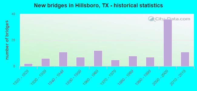
- New bridges - historical statistics
- 21920-1929
- 61930-1939
- 111940-1949
- 71950-1959
- 121960-1969
- 51970-1979
- 81980-1989
- 71990-1999
- 362000-2009
- 112010-2019

- Reconstructed bridges - Historical Statistics
- 21950-1959
- 01960-1969
- 31970-1979
- 21980-1989
- 21990-1999
- 52000-2009
- 12010-2019
- 12020-2022


- Bridge Condition - Deck
- 11.1%Very good
- 46.3%Good
- 20.4%Satisfactory
- 22.2%Fair

- Bridge Condition - Superstructure
- 7.4%Very good
- 33.3%Good
- 48.1%Satisfactory
- 11.1%Fair

- Bridge Condition - Substructure
- 5.6%Very good
- 27.8%Good
- 48.1%Satisfactory
- 13.0%Fair
- 3.7%Poor
- 1.9%Serious

- Bridge Condition - Channel
- 1.4%Very good
- 19.4%Good
- 52.8%Satisfactory
- 26.4%Fair

- Bridge Condition - Culverts
- 31.4%Good
- 48.6%Satisfactory
- 20.0%Fair
Find on map >> Show street view
Structure Number: 91100001406075, Location: 0.2 MI N OF FM 2959 (Lat: 32.092233, Lng: -97.128219), Route carried "on" structure: State highway 81, Year Built: 1946, Status: Open, Structure Length: 3.35m (10.99ft), Average Daily Traffic: 1,640 (year 2020), Truck Traffic: 19%, Average Future Daily Traffic: 1,967 (year 2039), Design Load: H 20, Features Intersected: LOVELACE CREEK
Minimum Vertical Clearance: 30+ m (98+ ft), Kilometerpoint: 17.978, Lanes on structure: 2, Owner: State Highway Agency, Approaching Roadway Width: 13.4m (44.0ft), Material/Design: Concrete continuous, Design/Construction: Slab, Number Of Spans In Main Unit: 4, Length of Maximum Span: 9.1m (29.9ft), Curb-To-Curb Width: 13.4m (44.0ft), Out-to-Out Width: 14.0m (45.9ft)
Condition: Deck: Fair, Superstructure: Fair, Substructure: Satisfactory, Channel: Satisfactory, Operating Rating: 53.5 metric tons, Method Used To Determine Operating Rating: Load Factor (LF), Inventory Rating: 31.7 metric tons, Method Used To Determine Inventory Rating: Load Factor (LF), Structural Evaluation: Somewhat better than minimum adequacy, Deck Geometry: Equal to present desirable criteria, Waterway Adequacy: Equal to present minimum criteria, Approach Roadway Alignment: Equal to present desirable criteria, Length Of Structure Improvement: 4.57m (14.99ft), Designated Inspection Frequency: Every 24 months, Inspection Date: December 2020, Bridge Improvement Cost: $500,000, Roadway Improvement Cost: $200,000, Total Project Cost: $800,000, Deck Structure Type: Concrete Cast-file-Place, Wearing Surface/Protective System: Wearing Surface: Bituminous
Find on map >> Show street view
Structure Number: 91100001406076, Location: 0.9 MI S OF FM 2959 (Lat: 32.076819, Lng: -97.126197), Route carried "on" structure: State highway 81, Year Built: 1946, Status: Open, Structure Length: 0.73m (2.40ft), Average Daily Traffic: 1,765 (year 2020), Truck Traffic: 19%, Average Future Daily Traffic: 1,967 (year 2039), Design Load: H 15, Features Intersected: MCDONALD CREEK
Minimum Vertical Clearance: 30+ m (98+ ft), Kilometerpoint: 19.705, Lanes on structure: 2, Owner: State Highway Agency, Approaching Roadway Width: 13.4m (44.0ft), Material/Design: Concrete, Design/Construction: Culvert, Number Of Spans In Main Unit: 3, Length of Maximum Span: 2.1m (6.9ft)
Condition: Channel: Satisfactory, Culverts: Satisfactory, Operating Rating: 39.9 metric tons, Method Used To Determine Operating Rating: Load Factor (LF), Inventory Rating: 23.6 metric tons, Method Used To Determine Inventory Rating: Load Factor (LF), Structural Evaluation: Equal to present minimum criteria, Waterway Adequacy: Equal to present minimum criteria, Approach Roadway Alignment: Equal to present desirable criteria, Length Of Structure Improvement: 1.83m (6.00ft), Designated Inspection Frequency: Every 24 months, Inspection Date: December 2020, Bridge Improvement Cost: $200,000, Roadway Improvement Cost: $100,000, Total Project Cost: $400,000
Find on map >> Show street view
Structure Number: 91100001406077, Location: 2.2 MI S OF FM 2959 (Lat: 32.058497, Lng: -97.121689), Route carried "on" structure: State highway 81, Year Built: 1946, Status: Open, Structure Length: 4.57m (14.99ft), Average Daily Traffic: 1,765 (year 2020), Truck Traffic: 19%, Average Future Daily Traffic: 1,967 (year 2039), Design Load: H 20, Features Intersected: LITTLE HACKBERRY CREEK
Minimum Vertical Clearance: 30+ m (98+ ft), Kilometerpoint: 21.781, Lanes on structure: 2, Owner: State Highway Agency, Approaching Roadway Width: 13.4m (44.0ft), Material/Design: Concrete continuous, Design/Construction: Slab, Number Of Spans In Main Unit: 6, Length of Maximum Span: 7.6m (24.9ft), Curb-To-Curb Width: 13.4m (44.0ft), Out-to-Out Width: 14.0m (45.9ft)
Condition: Deck: Fair, Superstructure: Fair, Substructure: Satisfactory, Channel: Satisfactory, Operating Rating: 54.4 metric tons, Method Used To Determine Operating Rating: Load Factor (LF), Inventory Rating: 32.7 metric tons, Method Used To Determine Inventory Rating: Load Factor (LF), Structural Evaluation: Somewhat better than minimum adequacy, Deck Geometry: Equal to present desirable criteria, Waterway Adequacy: Equal to present minimum criteria, Approach Roadway Alignment: Equal to present desirable criteria, Length Of Structure Improvement: 6.40m (21.00ft), Designated Inspection Frequency: Every 24 months, Inspection Date: January 2021, Bridge Improvement Cost: $700,000, Roadway Improvement Cost: $200,000, Total Project Cost: $1,100,000, Deck Structure Type: Concrete Cast-file-Place, Wearing Surface/Protective System: Wearing Surface: Bituminous
Find on map >> Show street view
Structure Number: 91100001406092, Location: 3.5 MI S OF FM 2959 (Lat: 32.039458, Lng: -97.114864), Route carried "on" structure: Alternate State highway 81, Year Built: 1952, Status: Open, Structure Length: 3.69m (12.11ft), Average Daily Traffic: 1,639 (year 2019), Truck Traffic: 19%, Average Future Daily Traffic: 1,967 (year 2039), Features Intersected: BOND CREEK
Minimum Vertical Clearance: 30+ m (98+ ft), Kilometerpoint: 23.986, Lanes on structure: 4, Owner: State Highway Agency, Approaching Roadway Width: 18.3m (60.0ft), Skew: 20 degrees, Material/Design: Steel continuous, Design/Construction: Stringer/Multi-beam, Number Of Spans In Main Unit: 3, Length of Maximum Span: 14.0m (45.9ft), Curb-To-Curb Width: 15.7m (51.5ft), Out-to-Out Width: 18.0m (59.1ft)
Condition: Deck: Fair, Superstructure: Satisfactory, Substructure: Satisfactory, Channel: Satisfactory, Operating Rating: 44.4 metric tons, Method Used To Determine Operating Rating: Load Factor (LF), Inventory Rating: 32.7 metric tons, Method Used To Determine Inventory Rating: Load Factor (LF), Structural Evaluation: Equal to present minimum criteria, Deck Geometry: Meets minimum limits, Waterway Adequacy: Equal to present minimum criteria, Approach Roadway Alignment: Equal to present desirable criteria, Length Of Structure Improvement: 5.03m (16.50ft), Designated Inspection Frequency: Every 24 months, Inspection Date: January 2021, Bridge Improvement Cost: $500,000, Roadway Improvement Cost: $200,000, Total Project Cost: $800,000, Deck Structure Type: Concrete Cast-file-Place
Find on map >> Show street view
Structure Number: 91100001406094, Location: 2.5 MI SE OF IH 35 (Lat: 32.022419, Lng: -97.126203), Route carried "on" structure: City street , Year Built: 1952, Status: Open, Structure Length: 3.90m (12.80ft), Average Daily Traffic: 228 (year 2020), Truck Traffic: 3%, Average Future Daily Traffic: 386 (year 2039), Features Intersected: SH 81, Facility Carried by Structure: PECOS ST
Minimum Vertical Clearance: 30+ m (98+ ft), Kilometerpoint: 1.320, Lanes on structure: 2, Lanes under structure: 4, Owner: State Highway Agency, Approaching Roadway Width: 9.8m (32.2ft), Skew: 5 degrees, Material/Design: Steel continuous, Design/Construction: Stringer/Multi-beam, Number Of Spans In Main Unit: 2, Length of Maximum Span: 19.2m (63.0ft), Curb-To-Curb Width: 7.8m (25.6ft), Out-to-Out Width: 8.9m (29.2ft)
Condition: Deck: Fair, Superstructure: Fair, Substructure: Satisfactory, Operating Rating: 38.1 metric tons, Method Used To Determine Operating Rating: Load Factor (LF), Inventory Rating: 22.7 metric tons, Method Used To Determine Inventory Rating: Load Factor (LF), Structural Evaluation: Somewhat better than minimum adequacy, Deck Geometry: Somewhat better than minimum adequacy, Underclear: Meets minimum limits, Approach Roadway Alignment: Equal to present desirable criteria, Length Of Structure Improvement: 5.03m (16.50ft), Designated Inspection Frequency: Every 24 months, Inspection Date: December 2020, Bridge Improvement Cost: $1,000,000, Roadway Improvement Cost: $300,000, Total Project Cost: $1,600,000, Deck Structure Type: Concrete Cast-file-Place
Find on map >> Show street view
Structure Number: 91100001406096, Location: 2.9 MI SE OF IH 35 (Lat: 32.017667, Lng: -97.129475), Route carried "on" structure: Alternate State highway 81, Year Built: 1952, Status: Open, Structure Length: 3.69m (12.11ft), Average Daily Traffic: 2,848 (year 2019), Truck Traffic: 10%, Average Future Daily Traffic: 3,987 (year 2039), Features Intersected: PECAN CREEK
Minimum Vertical Clearance: 30+ m (98+ ft), Kilometerpoint: 26.871, Lanes on structure: 2, Base Highway Network: Yes, Owner: State Highway Agency, Approaching Roadway Width: 9.8m (32.2ft), Material/Design: Steel continuous, Design/Construction: Stringer/Multi-beam, Number Of Spans In Main Unit: 3, Length of Maximum Span: 14.0m (45.9ft), Curb-To-Curb Width: 10.3m (33.8ft), Out-to-Out Width: 11.2m (36.7ft)
Condition: Deck: Fair, Superstructure: Satisfactory, Substructure: Fair, Channel: Satisfactory, Operating Rating: 44.4 metric tons, Method Used To Determine Operating Rating: Load Factor (LF), Inventory Rating: 31.7 metric tons, Method Used To Determine Inventory Rating: Load Factor (LF), Structural Evaluation: Somewhat better than minimum adequacy, Deck Geometry: Somewhat better than minimum adequacy, Waterway Adequacy: Equal to present minimum criteria, Approach Roadway Alignment: Equal to present desirable criteria, Length Of Structure Improvement: 5.03m (16.50ft), Designated Inspection Frequency: Every 24 months, Inspection Date: January 2021, Bridge Improvement Cost: $500,000, Roadway Improvement Cost: $200,000, Total Project Cost: $800,000, Deck Structure Type: Concrete Cast-file-Place
Find on map >> Show street view
Structure Number: 91100001406097, Location: 2.9 MI SE OF IH 35 (Lat: 32.017289, Lng: -97.129328), Route carried "on" structure: Alternate State highway 81, Year Built: 1952, Status: Open, Structure Length: 3.69m (12.11ft), Average Daily Traffic: 2,848 (year 2019), Truck Traffic: 10%, Average Future Daily Traffic: 3,987 (year 2039), Features Intersected: PECAN CREEK
Minimum Vertical Clearance: 30+ m (98+ ft), Kilometerpoint: 26.871, Lanes on structure: 2, Base Highway Network: Yes, Owner: State Highway Agency, Approaching Roadway Width: 9.8m (32.2ft), Material/Design: Steel continuous, Design/Construction: Stringer/Multi-beam, Number Of Spans In Main Unit: 3, Length of Maximum Span: 14.0m (45.9ft), Curb-To-Curb Width: 10.3m (33.8ft), Out-to-Out Width: 11.2m (36.7ft)
Condition: Deck: Fair, Superstructure: Satisfactory, Substructure: Fair, Channel: Satisfactory, Operating Rating: 44.4 metric tons, Method Used To Determine Operating Rating: Load Factor (LF), Inventory Rating: 31.7 metric tons, Method Used To Determine Inventory Rating: Load Factor (LF), Structural Evaluation: Somewhat better than minimum adequacy, Deck Geometry: Somewhat better than minimum adequacy, Waterway Adequacy: Equal to present minimum criteria, Approach Roadway Alignment: Equal to present desirable criteria, Length Of Structure Improvement: 5.03m (16.50ft), Designated Inspection Frequency: Every 24 months, Inspection Date: January 2021, Bridge Improvement Cost: $500,000, Roadway Improvement Cost: $200,000, Total Project Cost: $800,000, Deck Structure Type: Concrete Cast-file-Place
Find on map >> Show street view
Structure Number: 91100001406373, Location: 1.3 MI SE OF IH 35 (Lat: 32.035144, Lng: -97.114308), Route carried "on" structure: Alternate State highway 35, Year Built: 1952, Status: Open, Structure Length: 4.94m (16.21ft), Average Daily Traffic: 4,381 (year 2019), Truck Traffic: 11%, Average Future Daily Traffic: 6,309 (year 2039), Features Intersected: SH 81 NB, Facility Carried by Structure: SH 81 SB
Minimum Vertical Clearance: 30+ m (98+ ft), Kilometerpoint: 24.462, Lanes on structure: 1, Lanes under structure: 2, Base Highway Network: Yes, Owner: State Highway Agency, Approaching Roadway Width: 9.1m (29.9ft), Skew: 4 degrees, Material/Design: Steel continuous, Design/Construction: Stringer/Multi-beam, Number Of Spans In Main Unit: 1, Number Of Approach Spans: 2, Length of Maximum Span: 20.7m (67.9ft), Curb-To-Curb Width: 8.8m (28.9ft), Out-to-Out Width: 9.7m (31.8ft)
Condition: Deck: Fair, Superstructure: Satisfactory, Substructure: Satisfactory, Operating Rating: 44.4 metric tons, Method Used To Determine Operating Rating: Load Factor (LF), Inventory Rating: 32.7 metric tons, Method Used To Determine Inventory Rating: Load Factor (LF), Structural Evaluation: Equal to present minimum criteria, Deck Geometry: Meets minimum limits, Underclear: Somewhat better than minimum adequacy, Approach Roadway Alignment: Equal to present desirable criteria, Length Of Structure Improvement: 6.40m (21.00ft), Designated Inspection Frequency: Every 24 months, Inspection Date: December 2020, Bridge Improvement Cost: $700,000, Roadway Improvement Cost: $200,000, Total Project Cost: $1,100,000, Deck Structure Type: Concrete Cast-file-Place
Find on map >> Show street view
Structure Number: 91100001407068, Location: 5.0 MI N OF FM 1242 (Lat: 31.951469, Lng: -97.112983), Route carried "on" structure: Interstate 35, Year Built: 1941, Year Reconstructed: 2012, Status: Open, Structure Length: 1.49m (4.89ft), Average Daily Traffic: 57,963 (year 2020), Truck Traffic: 36%, Average Future Daily Traffic: 97,769 (year 2039), Design Load: H 15, Features Intersected: FOUR MILE CREEK
Minimum Vertical Clearance: 30+ m (98+ ft), Kilometerpoint: 13.235, Lanes on structure: 11, Base Highway Network: Yes, Owner: State Highway Agency, Approaching Roadway Width: 14.3m (46.9ft), Skew: 39 degrees, Material/Design: Concrete, Design/Construction: Culvert, Number Of Spans In Main Unit: 5, Length of Maximum Span: 2.7m (8.9ft)
Condition: Channel: Satisfactory, Culverts: Satisfactory, Operating Rating: 39.9 metric tons, Method Used To Determine Operating Rating: Load Factor (LF), Inventory Rating: 23.6 metric tons, Method Used To Determine Inventory Rating: Load Factor (LF), Structural Evaluation: Somewhat better than minimum adequacy, Waterway Adequacy: Equal to present minimum criteria, Approach Roadway Alignment: Equal to present desirable criteria, Designated Inspection Frequency: Every 24 months, Inspection Date: December 2020
Find on map >> Show street view
Structure Number: 91100001407069, Location: 0.6 MI N OF FM 310 (Lat: 31.965575, Lng: -97.119278), Route carried "on" structure: Interstate 35, Year Built: 1941, Year Reconstructed: 2012, Status: Open, Structure Length: 2.32m (7.61ft), Average Daily Traffic: 57,963 (year 2020), Truck Traffic: 36%, Average Future Daily Traffic: 97,769 (year 2039), Design Load: H 15, Features Intersected: THREE MILE CREEK
Minimum Vertical Clearance: 30+ m (98+ ft), Kilometerpoint: 14.915, Lanes on structure: 9, Base Highway Network: Yes, Owner: State Highway Agency, Approaching Roadway Width: 46.9m (153.9ft), Skew: 9 degrees, Material/Design: Concrete, Design/Construction: Culvert, Number Of Spans In Main Unit: 7, Length of Maximum Span: 3.0m (9.8ft)
Condition: Channel: Fair, Culverts: Fair, Operating Rating: 39.9 metric tons, Method Used To Determine Operating Rating: Load Factor (LF), Inventory Rating: 23.6 metric tons, Method Used To Determine Inventory Rating: Load Factor (LF), Structural Evaluation: Somewhat better than minimum adequacy, Waterway Adequacy: Superior to present desirable criteria, Approach Roadway Alignment: Equal to present desirable criteria, Length Of Structure Improvement: 3.05m (10.01ft), Designated Inspection Frequency: Every 24 months, Inspection Date: December 2020, Bridge Improvement Cost: $300,000, Roadway Improvement Cost: $100,000, Total Project Cost: $500,000
Find on map >> Show street view
Structure Number: 9110000140707, Location: 2.5 MI S OF SH 22 (Lat: 31.977217, Lng: -97.124186), Route carried "on" structure: Alternate State highway 81, Year Built: 1941, Year Reconstructed: 1957, Status: Posted for load, Structure Length: 2.65m (8.69ft), Average Daily Traffic: 4,708 (year 2019), Truck Traffic: 13%, Average Future Daily Traffic: 6,249 (year 2039), Design Load: H 15, Features Intersected: TWO MILE CREEK
Minimum Vertical Clearance: 30+ m (98+ ft), Kilometerpoint: 31.661, Lanes on structure: 8, Base Highway Network: Yes, Owner: State Highway Agency, Approaching Roadway Width: 38.4m (126.0ft), Skew: 20 degrees, Material/Design: Concrete, Design/Construction: Culvert, Number Of Spans In Main Unit: 8, Length of Maximum Span: 3.0m (9.8ft)
Condition: Channel: Fair, Culverts: Fair, Operating Rating: 39.9 metric tons, Method Used To Determine Operating Rating: Load Factor (LF), Inventory Rating: 23.6 metric tons, Method Used To Determine Inventory Rating: Load Factor (LF), Structural Evaluation: Somewhat better than minimum adequacy, Waterway Adequacy: Equal to present minimum criteria, Approach Roadway Alignment: Equal to present desirable criteria, Bridge Posting: Required (Relationship of Operating Rating to Maximum Legal Load: 0.1 - 9.9% below), Length Of Structure Improvement: 3.66m (12.01ft), Designated Inspection Frequency: Every 24 months, Inspection Date: December 2020, Bridge Improvement Cost: $500,000, Roadway Improvement Cost: $200,000, Total Project Cost: $800,000
Find on map >> Show street view
Structure Number: 91100001407218, Location: 0.60 MI N OF FM 310 (Lat: 31.965781, Lng: -97.118358), Route carried "on" structure: Ramp Interstate 35, Year Built: 1964, Year Reconstructed: 2008, Status: Open, Structure Length: 2.29m (7.51ft), Average Daily Traffic: 2,998 (year 2019), Truck Traffic: 13%, Average Future Daily Traffic: 4,197 (year 2039), Design Load: HS 20, Features Intersected: THREE MILE CREEK
Minimum Vertical Clearance: 30+ m (98+ ft), Kilometerpoint: 14.861, Lanes on structure: 3, Base Highway Network: Yes, Owner: State Highway Agency, Approaching Roadway Width: 24.4m (80.1ft), Material/Design: Concrete, Design/Construction: Culvert, Number Of Spans In Main Unit: 7, Length of Maximum Span: 3.0m (9.8ft)
Condition: Channel: Satisfactory, Culverts: Fair, Operating Rating: 39.9 metric tons, Method Used To Determine Operating Rating: Load Factor (LF), Inventory Rating: 23.6 metric tons, Method Used To Determine Inventory Rating: Load Factor (LF), Structural Evaluation: Somewhat better than minimum adequacy, Waterway Adequacy: Superior to present desirable criteria, Approach Roadway Alignment: Equal to present desirable criteria, Length Of Structure Improvement: 3.05m (10.01ft), Designated Inspection Frequency: Every 24 months, Inspection Date: December 2020, Bridge Improvement Cost: $300,000, Roadway Improvement Cost: $100,000, Total Project Cost: $500,000
Find on map >> Show street view
Structure Number: 91100001407475, Location: 4.1 MI N OF FM 1242 (Lat: 31.938783, Lng: -97.107303), Route carried "on" structure: Interstate 35, Year Built: 2001, Status: Open, Structure Length: 3.78m (12.40ft), Average Daily Traffic: 35,209 (year 2019), Truck Traffic: 36%, Average Future Daily Traffic: 48,885 (year 2039), Design Load: HS 20, Features Intersected: CHATT RD
Minimum Vertical Clearance: 30+ m (98+ ft), Kilometerpoint: 11.729, Lanes on structure: 3, Lanes under structure: 4, Base Highway Network: Yes, Owner: State Highway Agency, Approaching Roadway Width: 17.4m (57.1ft), Skew: 30 degrees, Material/Design: Prestressed concrete, Design/Construction: Stringer/Multi-beam, Number Of Spans In Main Unit: 1, Length of Maximum Span: 37.8m (124.0ft), Curb-To-Curb Width: 17.3m (56.8ft), Out-to-Out Width: 18.0m (59.1ft)
Condition: Deck: Satisfactory, Superstructure: Good, Substructure: Satisfactory, Operating Rating: 54.4 metric tons, Method Used To Determine Operating Rating: Assigned rating based on Load Factor Design (LFD) reported in metric tons, Inventory Rating: 32.7 metric tons, Method Used To Determine Inventory Rating: Assigned rating based on Load Factor Design (LFD) reported in metric tons, Structural Evaluation: Equal to present minimum criteria, Deck Geometry: Better than present minimum criteria, Underclear: Superior to present desirable criteria, Approach Roadway Alignment: Equal to present desirable criteria, Designated Inspection Frequency: Every 24 months, Inspection Date: November 2020, Deck Structure Type: Concrete Cast-file-Place
Find on map >> Show street view
Structure Number: 91100001407476, Location: 5.5 MI N OF FM 1242 (Lat: 31.957122, Lng: -97.115347), Route carried "on" structure: Interstate 35, Year Built: 2001, Status: Open, Structure Length: 3.78m (12.40ft), Average Daily Traffic: 35,209 (year 2019), Truck Traffic: 36%, Average Future Daily Traffic: 48,885 (year 2039), Design Load: HS 20, Features Intersected: FM 310
Minimum Vertical Clearance: 30+ m (98+ ft), Kilometerpoint: 13.911, Lanes on structure: 2, Lanes under structure: 4, Base Highway Network: Yes, Owner: State Highway Agency, Approaching Roadway Width: 17.4m (57.1ft), Skew: 30 degrees, Material/Design: Prestressed concrete, Design/Construction: Stringer/Multi-beam, Number Of Spans In Main Unit: 1, Length of Maximum Span: 37.8m (124.0ft), Curb-To-Curb Width: 17.4m (57.1ft), Out-to-Out Width: 18.0m (59.1ft)
Condition: Deck: Satisfactory, Superstructure: Satisfactory, Substructure: Satisfactory, Operating Rating: 54.4 metric tons, Method Used To Determine Operating Rating: Assigned rating based on Load Factor Design (LFD) reported in metric tons, Inventory Rating: 32.7 metric tons, Method Used To Determine Inventory Rating: Assigned rating based on Load Factor Design (LFD) reported in metric tons, Structural Evaluation: Equal to present minimum criteria, Deck Geometry: Superior to present desirable criteria, Underclear: Superior to present desirable criteria, Approach Roadway Alignment: Equal to present desirable criteria, Designated Inspection Frequency: Every 24 months, Inspection Date: November 2020, Deck Structure Type: Concrete Cast-file-Place, Wearing Surface/Protective System: Wearing Surface: Bituminous
Find on map >> Show street view
Structure Number: 91100001407482, Location: 4.1 MI N OF FM 1242 (Lat: 31.938703, Lng: -97.107531), Route carried "on" structure: Interstate 35, Year Built: 2001, Status: Open, Structure Length: 3.78m (12.40ft), Average Daily Traffic: 34,626 (year 2019), Truck Traffic: 36%, Average Future Daily Traffic: 48,884 (year 2039), Design Load: HS 20, Features Intersected: CHATT RD
Minimum Vertical Clearance: 30+ m (98+ ft), Kilometerpoint: 11.727, Lanes on structure: 3, Lanes under structure: 4, Owner: State Highway Agency, Approaching Roadway Width: 17.4m (57.1ft), Skew: 30 degrees, Material/Design: Prestressed concrete, Design/Construction: Stringer/Multi-beam, Number Of Spans In Main Unit: 1, Length of Maximum Span: 37.8m (124.0ft), Curb-To-Curb Width: 17.4m (57.1ft), Out-to-Out Width: 18.0m (59.1ft)
Condition: Deck: Good, Superstructure: Satisfactory, Substructure: Satisfactory, Operating Rating: 54.4 metric tons, Method Used To Determine Operating Rating: Assigned rating based on Load Factor Design (LFD) reported in metric tons, Inventory Rating: 32.7 metric tons, Method Used To Determine Inventory Rating: Assigned rating based on Load Factor Design (LFD) reported in metric tons, Structural Evaluation: Equal to present minimum criteria, Deck Geometry: Better than present minimum criteria, Underclear: Superior to present desirable criteria, Approach Roadway Alignment: Equal to present desirable criteria, Designated Inspection Frequency: Every 24 months, Inspection Date: November 2020, Deck Structure Type: Concrete Cast-file-Place
Find on map >> Show street view
Structure Number: 91100001407483, Location: 5.5 MI N OF FM 1242 (Lat: 31.957289, Lng: -97.115669), Route carried "on" structure: Interstate 35, Year Built: 2001, Status: Open, Structure Length: 3.78m (12.40ft), Average Daily Traffic: 34,626 (year 2019), Truck Traffic: 36%, Average Future Daily Traffic: 48,885 (year 2039), Design Load: HS 20, Features Intersected: FM 310
Minimum Vertical Clearance: 30+ m (98+ ft), Kilometerpoint: 13.911, Lanes on structure: 3, Lanes under structure: 6, Base Highway Network: Yes, Owner: State Highway Agency, Approaching Roadway Width: 17.4m (57.1ft), Skew: 30 degrees, Material/Design: Prestressed concrete, Design/Construction: Stringer/Multi-beam, Number Of Spans In Main Unit: 1, Length of Maximum Span: 37.8m (124.0ft), Curb-To-Curb Width: 17.4m (57.1ft), Out-to-Out Width: 18.0m (59.1ft)
Condition: Deck: Satisfactory, Superstructure: Satisfactory, Substructure: Satisfactory, Operating Rating: 54.4 metric tons, Method Used To Determine Operating Rating: Assigned rating based on Load Factor Design (LFD) reported in metric tons, Inventory Rating: 32.7 metric tons, Method Used To Determine Inventory Rating: Assigned rating based on Load Factor Design (LFD) reported in metric tons, Structural Evaluation: Equal to present minimum criteria, Deck Geometry: Better than present minimum criteria, Underclear: Superior to present desirable criteria, Approach Roadway Alignment: Equal to present desirable criteria, Designated Inspection Frequency: Every 24 months, Inspection Date: November 2020, Deck Structure Type: Concrete Cast-file-Place, Wearing Surface/Protective System: Wearing Surface: Bituminous
Find on map >> Show street view
Structure Number: 91100001423304, Location: 2.3 MI N OF IH 35E (Lat: 32.083181, Lng: -97.104644), Route carried "on" structure: Interstate 35, Year Built: 1967, Year Reconstructed: 2017, Status: Open, Structure Length: 1.59m (5.22ft), Average Daily Traffic: 30,926 (year 2020), Truck Traffic: 27%, Average Future Daily Traffic: 49,200 (year 2039), Design Load: HS 20, Features Intersected: LITTLE HACKBERRY CREEK
Minimum Vertical Clearance: 30+ m (98+ ft), Kilometerpoint: 28.712, Lanes on structure: 4, Base Highway Network: Yes, Owner: State Highway Agency, Approaching Roadway Width: 24.4m (80.1ft), Skew: 3 degrees, Material/Design: Concrete, Design/Construction: Culvert, Number Of Spans In Main Unit: 6, Length of Maximum Span: 2.1m (6.9ft)
Condition: Channel: Fair, Culverts: Satisfactory, Operating Rating: 39.9 metric tons, Method Used To Determine Operating Rating: Load Factor (LF), Inventory Rating: 23.6 metric tons, Method Used To Determine Inventory Rating: Load Factor (LF), Structural Evaluation: Somewhat better than minimum adequacy, Waterway Adequacy: Superior to present desirable criteria, Approach Roadway Alignment: Equal to present desirable criteria, Length Of Structure Improvement: 2.74m (8.99ft), Designated Inspection Frequency: Every 24 months, Inspection Date: November 2020, Bridge Improvement Cost: $800,000, Roadway Improvement Cost: $200,000, Total Project Cost: $1,200,000
Find on map >> Show street view
Structure Number: 91100001423305, Location: 1.7 MI N OF IH 35E (Lat: 32.074644, Lng: -97.102011), Route carried "on" structure: Interstate 35, Year Built: 1967, Status: Open, Structure Length: 0.91m (2.99ft), Average Daily Traffic: 30,926 (year 2020), Truck Traffic: 27%, Average Future Daily Traffic: 49,200 (year 2039), Design Load: HS 20, Features Intersected: TR LITTLE HACKBERRY CRK
Minimum Vertical Clearance: 30+ m (98+ ft), Kilometerpoint: 27.727, Lanes on structure: 4, Base Highway Network: Yes, Owner: State Highway Agency, Approaching Roadway Width: 24.4m (80.1ft), Skew: 1 degrees, Material/Design: Concrete, Design/Construction: Culvert, Number Of Spans In Main Unit: 3, Length of Maximum Span: 2.7m (8.9ft)
Condition: Channel: Fair, Culverts: Fair, Operating Rating: 39.9 metric tons, Method Used To Determine Operating Rating: Load Factor (LF), Inventory Rating: 23.6 metric tons, Method Used To Determine Inventory Rating: Load Factor (LF), Structural Evaluation: Somewhat better than minimum adequacy, Waterway Adequacy: Superior to present desirable criteria, Approach Roadway Alignment: Equal to present desirable criteria, Length Of Structure Improvement: 1.83m (6.00ft), Designated Inspection Frequency: Every 24 months, Inspection Date: November 2020, Bridge Improvement Cost: $200,000, Roadway Improvement Cost: $100,000, Total Project Cost: $400,000
Find on map >> Show street view
Structure Number: 91100001423306, Location: 0.8 MI N OF IH 35E (Lat: 32.062469, Lng: -97.097408), Route carried "on" structure: County highway 35, Year Built: 1967, Status: Posted for load, Structure Length: 9.45m (31.00ft), Average Daily Traffic: 100 (year 2019), Truck Traffic: 3%, Average Future Daily Traffic: 100 (year 2039), Design Load: H 15, Features Intersected: IH 35W
Minimum Vertical Clearance: 5.30m (17.39ft), Kilometerpoint: 26.321, Lanes on structure: 2, Lanes under structure: 4, Owner: State Highway Agency, Approaching Roadway Width: 5.5m (18.0ft), Skew: 1 degrees, Material/Design: Concrete continuous, Design/Construction: Tee Beam, Number Of Spans In Main Unit: 2, Number Of Approach Spans: 4, Length of Maximum Span: 23.5m (77.1ft), Curb-To-Curb Width: 7.3m (24.0ft), Out-to-Out Width: 8.6m (28.2ft)
Condition: Deck: Good, Superstructure: Satisfactory, Substructure: Satisfactory, Operating Rating: 37.2 metric tons, Method Used To Determine Operating Rating: Load Factor (LF), Inventory Rating: 21.8 metric tons, Method Used To Determine Inventory Rating: Load Factor (LF), Structural Evaluation: Somewhat better than minimum adequacy, Deck Geometry: Equal to present minimum criteria, Underclear: Somewhat better than minimum adequacy, Approach Roadway Alignment: Equal to present desirable criteria, Bridge Posting: Required (Relationship of Operating Rating to Maximum Legal Load: 0.1 - 9.9% below), Length Of Structure Improvement: 11.83m (38.81ft), Designated Inspection Frequency: Every 24 months, Inspection Date: November 2020, Bridge Improvement Cost: $1,300,000, Roadway Improvement Cost: $400,000, Total Project Cost: $2,000,000, Deck Structure Type: Concrete Cast-file-Place
Find on map >> Show street view
Structure Number: 91100001423307, Location: 0.8 MI N OF IH 35E (Lat: 32.062553, Lng: -97.097514), Route carried "on" structure: Interstate 35, Year Built: 1967, Status: Open, Structure Length: 2.77m (9.09ft), Average Daily Traffic: 30,926 (year 2020), Truck Traffic: 27%, Average Future Daily Traffic: 49,200 (year 2039), Design Load: HS 20, Features Intersected: BR LITTLE HACKBERRY CRK
Minimum Vertical Clearance: 30+ m (98+ ft), Kilometerpoint: 26.308, Lanes on structure: 4, Base Highway Network: Yes, Owner: State Highway Agency, Approaching Roadway Width: 24.4m (80.1ft), Skew: 4 degrees, Material/Design: Concrete, Design/Construction: Culvert, Number Of Spans In Main Unit: 6, Length of Maximum Span: 3.0m (9.8ft)
Condition: Channel: Satisfactory, Culverts: Fair, Operating Rating: 39.9 metric tons, Method Used To Determine Operating Rating: Load Factor (LF), Inventory Rating: 23.6 metric tons, Method Used To Determine Inventory Rating: Load Factor (LF), Structural Evaluation: Somewhat better than minimum adequacy, Waterway Adequacy: Superior to present desirable criteria, Approach Roadway Alignment: Equal to present desirable criteria, Length Of Structure Improvement: 3.66m (12.01ft), Designated Inspection Frequency: Every 24 months, Inspection Date: November 2020, Bridge Improvement Cost: $400,000, Roadway Improvement Cost: $100,000, Total Project Cost: $600,000
Find on map >> Show street view
Structure Number: 9110000142404, Location: 0.7 MI S OF SH 22 (Lat: 31.999336, Lng: -97.097939), Route carried "on" structure: State highway 3267, Year Built: 2009, Status: Open, Structure Length: 9.45m (31.00ft), Average Daily Traffic: 1,052 (year 2019), Truck Traffic: 12%, Average Future Daily Traffic: 1,262 (year 2039), Design Load: HL 93, Features Intersected: IH 35
Minimum Vertical Clearance: 30+ m (98+ ft), Kilometerpoint: 3.420, Lanes on structure: 3, Lanes under structure: 6, Owner: State Highway Agency, Approaching Roadway Width: 19.5m (64.0ft), Material/Design: Steel, Design/Construction: Box Beam or Girders - Multiple, Number Of Spans In Main Unit: 2, Number Of Approach Spans: 2, Length of Maximum Span: 30.5m (100.1ft), Curb or Sidewalk Widths: Left: 1.8m (5.9ft), Right: 1.8m (5.9ft), Curb-To-Curb Width: 19.5m (64.0ft), Out-to-Out Width: 23.8m (78.1ft)
Condition: Deck: Good, Superstructure: Good, Substructure: Good, Operating Rating: 54.4 metric tons, Method Used To Determine Operating Rating: Assigned ratings based on Load and Resistance Factor Design (LRFD) reported in metric tons, Inventory Rating: 32.7 metric tons, Method Used To Determine Inventory Rating: Assigned ratings based on Load and Resistance Factor Design (LRFD) reported in metric tons, Structural Evaluation: Better than present minimum criteria, Deck Geometry: Superior to present desirable criteria, Underclear: Equal to present minimum criteria, Approach Roadway Alignment: Equal to present desirable criteria, Length Of Structure Improvement: 9.75m (31.99ft), Designated Inspection Frequency: Every 24 months, Inspection Date: December 2020, Bridge Improvement Cost: $870,000, Roadway Improvement Cost: $218,000, Total Project Cost: $1,088,000, Deck Structure Type: Concrete Cast-file-Place
Find on map >> Show street view
Structure Number: 91100001424062, Location: 0.5 MI N OF US 81 (Lat: 31.973119, Lng: -97.116028), Route carried "on" structure: County highway , Year Built: 2010, Status: Open, Structure Length: 10.85m (35.60ft), Average Daily Traffic: 100 (year 2019), Truck Traffic: 3%, Average Future Daily Traffic: 100 (year 2039), Design Load: HL 93, Features Intersected: IH 35, Facility Carried by Structure: HCR 3102/OLD US 77
Minimum Vertical Clearance: 30+ m (98+ ft), Kilometerpoint: 15.820, Lanes on structure: 2, Lanes under structure: 7, Owner: State Highway Agency, Approaching Roadway Width: 13.4m (44.0ft), Skew: 3 degrees, Material/Design: Steel, Design/Construction: Box Beam or Girders - Multiple, Number Of Spans In Main Unit: 2, Number Of Approach Spans: 2, Length of Maximum Span: 41.1m (134.8ft), Curb-To-Curb Width: 13.4m (44.0ft), Out-to-Out Width: 14.0m (45.9ft)
Condition: Deck: Good, Superstructure: Very good, Substructure: Good, Operating Rating: 54.4 metric tons, Method Used To Determine Operating Rating: Assigned ratings based on Load and Resistance Factor Design (LRFD) reported in metric tons, Inventory Rating: 32.7 metric tons, Method Used To Determine Inventory Rating: Assigned ratings based on Load and Resistance Factor Design (LRFD) reported in metric tons, Structural Evaluation: Better than present minimum criteria, Deck Geometry: Superior to present desirable criteria, Underclear: Meets minimum limits, Approach Roadway Alignment: Equal to present desirable criteria, Designated Inspection Frequency: Every 24 months, Inspection Date: December 2020, Deck Structure Type: Concrete Cast-file-Place
Find on map >> Show street view
Structure Number: 91100001424063, Location: 2.8 MI S OF SH 22 (Lat: 31.968075, Lng: -97.118833), Route carried "on" structure: Alternate US 81, Year Built: 2007, Status: Open, Structure Length: 12.56m (41.21ft), Average Daily Traffic: 2,998 (year 2019), Truck Traffic: 13%, Average Future Daily Traffic: 4,197 (year 2039), Design Load: HL 93, Features Intersected: IH 35
Minimum Vertical Clearance: 30+ m (98+ ft), Kilometerpoint: 15.305, Lanes on structure: 1, Lanes under structure: 6, Base Highway Network: Yes, Owner: State Highway Agency, Approaching Roadway Width: 7.9m (25.9ft), Skew: 4 degrees, Material/Design: Steel continuous, Design/Construction: Stringer/Multi-beam, Number Of Spans In Main Unit: 2, Number Of Approach Spans: 2, Length of Maximum Span: 41.1m (134.8ft), Curb-To-Curb Width: 7.9m (25.9ft), Out-to-Out Width: 8.5m (27.9ft)
Condition: Deck: Good, Superstructure: Good, Substructure: Good, Operating Rating: 54.4 metric tons, Method Used To Determine Operating Rating: Assigned ratings based on Load and Resistance Factor Design (LRFD) reported in metric tons, Inventory Rating: 32.7 metric tons, Method Used To Determine Inventory Rating: Assigned ratings based on Load and Resistance Factor Design (LRFD) reported in metric tons, Structural Evaluation: Better than present minimum criteria, Deck Geometry: High priority of corrective action, Underclear: Equal to present minimum criteria, Approach Roadway Alignment: Equal to present desirable criteria, Designated Inspection Frequency: Every 24 months, Inspection Date: December 2020, Deck Structure Type: Concrete Cast-file-Place
Find on map >> Show street view
Structure Number: 91100001424064, Location: 3.0 MI S OF SH 22 (Lat: 31.970322, Lng: -97.120383), Route carried "on" structure: Ramp Interstate 35, Year Built: 2010, Status: Open, Structure Length: 23.77m (77.99ft), Average Daily Traffic: 283 (year 2019), Truck Traffic: 11%, Average Future Daily Traffic: 340 (year 2039), Design Load: HL 93, Features Intersected: SH 81
Minimum Vertical Clearance: 30+ m (98+ ft), Kilometerpoint: 0.000, Lanes on structure: 2, Lanes under structure: 2, Owner: State Highway Agency, Approaching Roadway Width: 11.0m (36.1ft), Material/Design: Steel continuous, Design/Construction: Stringer/Multi-beam, Number Of Spans In Main Unit: 6, Length of Maximum Span: 45.7m (149.9ft), Curb-To-Curb Width: 11.0m (36.1ft), Out-to-Out Width: 11.6m (38.1ft)
Condition: Deck: Good, Superstructure: Very good, Substructure: Satisfactory, Operating Rating: 54.4 metric tons, Method Used To Determine Operating Rating: Assigned ratings based on Load and Resistance Factor Design (LRFD) reported in metric tons, Inventory Rating: 32.7 metric tons, Method Used To Determine Inventory Rating: Assigned ratings based on Load and Resistance Factor Design (LRFD) reported in metric tons, Structural Evaluation: Equal to present minimum criteria, Deck Geometry: Better than present minimum criteria, Underclear: Equal to present minimum criteria, Approach Roadway Alignment: Equal to present desirable criteria, Designated Inspection Frequency: Every 24 months, Inspection Date: December 2020, Deck Structure Type: Concrete Cast-file-Place
Find on map >> Show street view
Structure Number: 91100001424078, Location: 0.60 MI S OF FM 3267 (Lat: 31.982578, Lng: -97.109653), Route carried "on" structure: Interstate 35, Year Built: 2008, Status: Open, Structure Length: 8.08m (26.51ft), Average Daily Traffic: 56,429 (year 2020), Truck Traffic: 36%, Average Future Daily Traffic: 95,182 (year 2039), Design Load: HL 93, Features Intersected: UP RR
Minimum Vertical Clearance: 30+ m (98+ ft), Kilometerpoint: 17.033, Lanes on structure: 6, Base Highway Network: Yes, Owner: State Highway Agency, Approaching Roadway Width: 45.1m (148.0ft), Skew: 31 degrees, Material/Design: Prestressed concrete, Design/Construction: Stringer/Multi-beam, Number Of Spans In Main Unit: 1, Number Of Approach Spans: 2, Length of Maximum Span: 35.1m (115.2ft), Curb-To-Curb Width: 45.1m (148.0ft), Out-to-Out Width: 46.9m (153.9ft)
Condition: Deck: Good, Superstructure: Good, Substructure: Satisfactory, Operating Rating: 54.4 metric tons, Method Used To Determine Operating Rating: Assigned ratings based on Load and Resistance Factor Design (LRFD) reported in metric tons, Inventory Rating: 32.7 metric tons, Method Used To Determine Inventory Rating: Assigned ratings based on Load and Resistance Factor Design (LRFD) reported in metric tons, Structural Evaluation: Equal to present minimum criteria, Deck Geometry: Superior to present desirable criteria, Underclear: Better than present minimum criteria, Approach Roadway Alignment: Equal to present desirable criteria, Designated Inspection Frequency: Every 24 months, Inspection Date: December 2020, Deck Structure Type: Concrete Cast-file-Place
Find on map >> Show street view
Structure Number: 91100001424205, Location: 2.5 MI S OF IH 35E/IH 35W (Lat: 32.014539, Lng: -97.096167), Route carried "on" structure: Interstate 35, Year Built: 1964, Year Reconstructed: 2002, Status: Open, Structure Length: 0.91m (2.99ft), Average Daily Traffic: 48,755 (year 2020), Truck Traffic: 39%, Average Future Daily Traffic: 82,237 (year 2039), Design Load: HS 20, Features Intersected: TRIB PECAN CREEK
Minimum Vertical Clearance: 30+ m (98+ ft), Kilometerpoint: 20.883, Lanes on structure: 11, Base Highway Network: Yes, Owner: State Highway Agency, Approaching Roadway Width: 57.9m (190.0ft), Material/Design: Concrete, Design/Construction: Culvert, Number Of Spans In Main Unit: 4, Length of Maximum Span: 2.1m (6.9ft)
Condition: Channel: Satisfactory, Culverts: Satisfactory, Operating Rating: 39.9 metric tons, Method Used To Determine Operating Rating: Load Factor (LF), Inventory Rating: 23.6 metric tons, Method Used To Determine Inventory Rating: Load Factor (LF), Structural Evaluation: Somewhat better than minimum adequacy, Waterway Adequacy: Equal to present minimum criteria, Approach Roadway Alignment: Equal to present desirable criteria, Length Of Structure Improvement: 1.83m (6.00ft), Designated Inspection Frequency: Every 24 months, Inspection Date: December 2020, Bridge Improvement Cost: $200,000, Roadway Improvement Cost: $100,000, Total Project Cost: $400,000
Find on map >> Show street view
Structure Number: 91100001424208, Location: 0.4 MI S OF SH 22 (Lat: 32.003219, Lng: -97.095572), Route carried "on" structure: Interstate 35, Year Built: 1964, Status: Open, Structure Length: 1.40m (4.59ft), Average Daily Traffic: 48,755 (year 2020), Truck Traffic: 39%, Average Future Daily Traffic: 82,237 (year 2039), Design Load: HS 20, Features Intersected: TWO MILE CREEK
Minimum Vertical Clearance: 30+ m (98+ ft), Kilometerpoint: 19.599, Lanes on structure: 8, Base Highway Network: Yes, Owner: State Highway Agency, Approaching Roadway Width: 42.7m (140.1ft), Skew: 4 degrees, Material/Design: Concrete, Design/Construction: Culvert, Number Of Spans In Main Unit: 3, Length of Maximum Span: 3.0m (9.8ft)
Condition: Channel: Fair, Culverts: Satisfactory, Operating Rating: 39.9 metric tons, Method Used To Determine Operating Rating: Load Factor (LF), Inventory Rating: 23.6 metric tons, Method Used To Determine Inventory Rating: Load Factor (LF), Structural Evaluation: Somewhat better than minimum adequacy, Waterway Adequacy: Superior to present desirable criteria, Approach Roadway Alignment: Equal to present desirable criteria, Length Of Structure Improvement: 1.83m (6.00ft), Designated Inspection Frequency: Every 24 months, Inspection Date: December 2020, Bridge Improvement Cost: $200,000, Roadway Improvement Cost: $100,000, Total Project Cost: $400,000
Find on map >> Show street view
Structure Number: 9110000142421, Location: 0.5 MI S OF SH 22 (Lat: 32.001208, Lng: -97.096581), Route carried "on" structure: Interstate 35, Year Built: 1964, Year Reconstructed: 2012, Status: Open, Structure Length: 1.37m (4.49ft), Average Daily Traffic: 48,755 (year 2020), Truck Traffic: 39%, Average Future Daily Traffic: 82,237 (year 2039), Design Load: HS 20, Features Intersected: BRANCH OF TWO MILE CREEK
Minimum Vertical Clearance: 30+ m (98+ ft), Kilometerpoint: 19.401, Lanes on structure: 6, Base Highway Network: Yes, Owner: State Highway Agency, Approaching Roadway Width: 24.4m (80.1ft), Skew: 1 degrees, Material/Design: Concrete, Design/Construction: Culvert, Number Of Spans In Main Unit: 5, Length of Maximum Span: 2.4m (7.9ft)
Condition: Channel: Satisfactory, Culverts: Good, Operating Rating: 39.9 metric tons, Method Used To Determine Operating Rating: Load Factor (LF), Inventory Rating: 23.6 metric tons, Method Used To Determine Inventory Rating: Load Factor (LF), Structural Evaluation: Somewhat better than minimum adequacy, Waterway Adequacy: Superior to present desirable criteria, Approach Roadway Alignment: Equal to present desirable criteria, Length Of Structure Improvement: 1.83m (6.00ft), Designated Inspection Frequency: Every 24 months, Inspection Date: December 2020, Bridge Improvement Cost: $200,000, Roadway Improvement Cost: $100,000, Total Project Cost: $400,000
Find on map >> Show street view
Structure Number: 91100001424213, Location: 0.7 MI S OF FM 3267 (Lat: 31.991200, Lng: -97.104436), Route carried "on" structure: Interstate 35, Year Built: 1964, Year Reconstructed: 2012, Status: Open, Structure Length: 0.70m (2.30ft), Average Daily Traffic: 56,429 (year 2020), Truck Traffic: 36%, Average Future Daily Traffic: 95,182 (year 2039), Design Load: HS 20, Features Intersected: TRIB TWO MILE CREEK
Minimum Vertical Clearance: 30+ m (98+ ft), Kilometerpoint: 18.071, Lanes on structure: 6, Base Highway Network: Yes, Owner: State Highway Agency, Approaching Roadway Width: 24.4m (80.1ft), Skew: 33 degrees, Material/Design: Concrete, Design/Construction: Culvert, Number Of Spans In Main Unit: 2, Length of Maximum Span: 2.7m (8.9ft)
Condition: Channel: Fair, Culverts: Satisfactory, Operating Rating: 39.9 metric tons, Method Used To Determine Operating Rating: Load Factor (LF), Inventory Rating: 23.6 metric tons, Method Used To Determine Inventory Rating: Load Factor (LF), Structural Evaluation: Somewhat better than minimum adequacy, Waterway Adequacy: Superior to present desirable criteria, Approach Roadway Alignment: Equal to present desirable criteria, Length Of Structure Improvement: 1.83m (6.00ft), Designated Inspection Frequency: Every 24 months, Inspection Date: December 2020, Bridge Improvement Cost: $200,000, Roadway Improvement Cost: $100,000, Total Project Cost: $400,000
Find on map >> Show street view
Structure Number: 91100001424467, Location: 0.5 MI S OF SH 22 (Lat: 32.001739, Lng: -97.098044), Route carried "on" structure: ServiceInterstate 35, Year Built: 2001, Status: Open, Structure Length: 1.80m (5.91ft), Average Daily Traffic: 3,643 (year 2019), Truck Traffic: 8%, Average Future Daily Traffic: 4,372 (year 2039), Design Load: HS 20, Features Intersected: BRANCH OF TWO MILE CREEK
Minimum Vertical Clearance: 30+ m (98+ ft), Kilometerpoint: 19.401, Lanes on structure: 2, Owner: State Highway Agency, Approaching Roadway Width: 8.5m (27.9ft), Skew: 3 degrees, Material/Design: Concrete, Design/Construction: Culvert, Number Of Spans In Main Unit: 6, Length of Maximum Span: 2.4m (7.9ft)
Condition: Channel: Good, Culverts: Good, Operating Rating: 54.4 metric tons, Method Used To Determine Operating Rating: Assigned rating based on Load Factor Design (LFD) reported in metric tons, Inventory Rating: 32.7 metric tons, Method Used To Determine Inventory Rating: Assigned rating based on Load Factor Design (LFD) reported in metric tons, Structural Evaluation: Better than present minimum criteria, Waterway Adequacy: Equal to present minimum criteria, Approach Roadway Alignment: Equal to present desirable criteria, Designated Inspection Frequency: Every 48 months, Inspection Date: December 2020
Find on map >> Show street view
Structure Number: 91100001424468, Location: 0.3 MI N OF SH 22 (Lat: 32.013081, Lng: -97.095864), Route carried "on" structure: Interstate 35, Year Built: 2002, Status: Open, Structure Length: 0.73m (2.40ft), Average Daily Traffic: 48,755 (year 2020), Truck Traffic: 39%, Average Future Daily Traffic: 82,237 (year 2039), Design Load: HS 20, Features Intersected: DRAIN
Minimum Vertical Clearance: 30+ m (98+ ft), Kilometerpoint: 20.883, Lanes on structure: 9, Base Highway Network: Yes, Owner: State Highway Agency, Approaching Roadway Width: 36.6m (120.1ft), Skew: 34 degrees, Material/Design: Concrete, Design/Construction: Culvert, Number Of Spans In Main Unit: 3, Length of Maximum Span: 1.5m (4.9ft)
Condition: Channel: Satisfactory, Culverts: Satisfactory, Operating Rating: 54.4 metric tons, Method Used To Determine Operating Rating: Assigned rating based on Load Factor Design (LFD) reported in metric tons, Inventory Rating: 32.7 metric tons, Method Used To Determine Inventory Rating: Assigned rating based on Load Factor Design (LFD) reported in metric tons, Structural Evaluation: Equal to present minimum criteria, Waterway Adequacy: Superior to present desirable criteria, Approach Roadway Alignment: Equal to present desirable criteria, Designated Inspection Frequency: Every 48 months, Inspection Date: December 2020
Find on map >> Show street view
Structure Number: 91100001424469, Location: 0.3 MI N OF SH 22 (Lat: 32.013278, Lng: -97.096036), Route carried "on" structure: ServiceInterstate 35, Year Built: 2002, Status: Open, Structure Length: 0.76m (2.49ft), Average Daily Traffic: 3,643 (year 2019), Truck Traffic: 8%, Average Future Daily Traffic: 4,372 (year 2039), Design Load: HS 20, Features Intersected: DRAINAGE DITCH
Minimum Vertical Clearance: 30+ m (98+ ft), Kilometerpoint: 20.883, Lanes on structure: 3, Owner: State Highway Agency, Approaching Roadway Width: 15.9m (52.2ft), Skew: 4 degrees, Material/Design: Concrete, Design/Construction: Culvert, Number Of Spans In Main Unit: 3, Length of Maximum Span: 1.5m (4.9ft)
Condition: Channel: Satisfactory, Culverts: Good, Operating Rating: 54.4 metric tons, Method Used To Determine Operating Rating: Assigned rating based on Load Factor Design (LFD) reported in metric tons, Inventory Rating: 32.7 metric tons, Method Used To Determine Inventory Rating: Assigned rating based on Load Factor Design (LFD) reported in metric tons, Structural Evaluation: Better than present minimum criteria, Waterway Adequacy: Equal to present minimum criteria, Approach Roadway Alignment: Equal to present desirable criteria, Designated Inspection Frequency: Every 48 months, Inspection Date: December 2020
Find on map >> Show street view
Structure Number: 91100001424471, Location: 0.7 MI N OF FM 3267 (Lat: 32.008783, Lng: -97.095047), Route carried "on" structure: State highway 22, Year Built: 2001, Status: Open, Structure Length: 8.90m (29.20ft), Average Daily Traffic: 13,459 (year 2019), Truck Traffic: 11%, Average Future Daily Traffic: 16,151 (year 2039), Design Load: HS 20, Features Intersected: IH 35
Minimum Vertical Clearance: 30+ m (98+ ft), Kilometerpoint: 20.242, Lanes on structure: 6, Lanes under structure: 6, Base Highway Network: Yes, Owner: State Highway Agency, Approaching Roadway Width: 21.6m (70.9ft), Material/Design: Prestressed concrete, Design/Construction: Stringer/Multi-beam, Number Of Spans In Main Unit: 2, Number Of Approach Spans: 2, Length of Maximum Span: 27.4m (89.9ft), Curb or Sidewalk Widths: Left: 1.8m (5.9ft), Right: 1.8m (5.9ft), Curb-To-Curb Width: 21.6m (70.9ft), Out-to-Out Width: 26.1m (85.6ft)
Condition: Deck: Satisfactory, Superstructure: Satisfactory, Substructure: Satisfactory, Operating Rating: 54.4 metric tons, Method Used To Determine Operating Rating: Assigned rating based on Load Factor Design (LFD) reported in metric tons, Inventory Rating: 32.7 metric tons, Method Used To Determine Inventory Rating: Assigned rating based on Load Factor Design (LFD) reported in metric tons, Structural Evaluation: Equal to present minimum criteria, Deck Geometry: High priority of replacement, Underclear: Somewhat better than minimum adequacy, Approach Roadway Alignment: Equal to present desirable criteria, Length Of Structure Improvement: 8.90m (29.20ft), Designated Inspection Frequency: Every 24 months, Inspection Date: December 2020, Bridge Improvement Cost: $41,000, Roadway Improvement Cost: $10,000, Total Project Cost: $51,000, Deck Structure Type: Concrete Cast-file-Place
Find on map >> Show street view
Structure Number: 91100001424472, Location: 0.6 MI N OF SH 22 (Lat: 32.016689, Lng: -97.095464), Route carried "on" structure: Interstate 35, Year Built: 2001, Status: Open, Structure Length: 9.21m (30.22ft), Average Daily Traffic: 29,499 (year 2019), Truck Traffic: 39%, Average Future Daily Traffic: 41,119 (year 2039), Design Load: HS 20, Features Intersected: FM 286
Minimum Vertical Clearance: 30+ m (98+ ft), Kilometerpoint: 21.160, Lanes on structure: 3, Lanes under structure: 6, Base Highway Network: Yes, Owner: State Highway Agency, Approaching Roadway Width: 17.1m (56.1ft), Skew: 30 degrees, Material/Design: Prestressed concrete, Design/Construction: Stringer/Multi-beam, Number Of Spans In Main Unit: 3, Length of Maximum Span: 32.9m (107.9ft), Curb-To-Curb Width: 19.6m (64.3ft), Out-to-Out Width: 20.3m (66.6ft)
Condition: Deck: Good, Superstructure: Satisfactory, Substructure: Satisfactory, Operating Rating: 54.4 metric tons, Method Used To Determine Operating Rating: Assigned rating based on Load Factor Design (LFD) reported in metric tons, Inventory Rating: 32.7 metric tons, Method Used To Determine Inventory Rating: Assigned rating based on Load Factor Design (LFD) reported in metric tons, Structural Evaluation: Equal to present minimum criteria, Deck Geometry: Superior to present desirable criteria, Underclear: Superior to present desirable criteria, Approach Roadway Alignment: Equal to present desirable criteria, Designated Inspection Frequency: Every 24 months, Inspection Date: December 2020, Deck Structure Type: Concrete Cast-file-Place
Find on map >> Show street view
Structure Number: 91100001424479, Location: 0.6 MI N OF SH 22 (Lat: 32.017164, Lng: -97.095775), Route carried "on" structure: Interstate 35, Year Built: 2001, Status: Open, Structure Length: 9.21m (30.22ft), Average Daily Traffic: 33,457 (year 2019), Truck Traffic: 36%, Average Future Daily Traffic: 47,719 (year 2039), Design Load: HS 20, Features Intersected: FM 286
Minimum Vertical Clearance: 30+ m (98+ ft), Kilometerpoint: 21.160, Lanes on structure: 3, Lanes under structure: 6, Base Highway Network: Yes, Owner: State Highway Agency, Approaching Roadway Width: 21.3m (69.9ft), Skew: 30 degrees, Material/Design: Prestressed concrete, Design/Construction: Stringer/Multi-beam, Number Of Spans In Main Unit: 3, Length of Maximum Span: 32.9m (107.9ft), Curb-To-Curb Width: 21.4m (70.2ft), Out-to-Out Width: 22.0m (72.2ft)
Condition: Deck: Good, Superstructure: Good, Substructure: Satisfactory, Operating Rating: 54.4 metric tons, Method Used To Determine Operating Rating: Assigned rating based on Load Factor Design (LFD) reported in metric tons, Inventory Rating: 32.7 metric tons, Method Used To Determine Inventory Rating: Assigned rating based on Load Factor Design (LFD) reported in metric tons, Structural Evaluation: Equal to present minimum criteria, Deck Geometry: Superior to present desirable criteria, Underclear: Superior to present desirable criteria, Approach Roadway Alignment: Equal to present desirable criteria, Designated Inspection Frequency: Every 24 months, Inspection Date: December 2020, Deck Structure Type: Concrete Cast-file-Place
Find on map >> Show street view
Structure Number: 91100001424484, Location: 1.9 MI N OF FM 286 (Lat: 32.044392, Lng: -97.094669), Route carried "on" structure: Interstate 35, Year Built: 2008, Status: Open, Structure Length: 7.92m (25.98ft), Average Daily Traffic: 56,580 (year 2020), Truck Traffic: 36%, Average Future Daily Traffic: 95,437 (year 2039), Design Load: HS 25 or greater, Features Intersected: US 77
Minimum Vertical Clearance: 30+ m (98+ ft), Kilometerpoint: 24.203, Lanes on structure: 6, Lanes under structure: 4, Base Highway Network: Yes, Owner: State Highway Agency, Approaching Roadway Width: 40.2m (131.9ft), Skew: 33 degrees, Material/Design: Prestressed concrete, Design/Construction: Stringer/Multi-beam, Number Of Spans In Main Unit: 4, Length of Maximum Span: 19.8m (65.0ft), Curb-To-Curb Width: 46.9m (153.9ft), Out-to-Out Width: 46.9m (153.9ft)
Condition: Deck: Good, Superstructure: Good, Substructure: Good, Operating Rating: 55.3 metric tons, Method Used To Determine Operating Rating: Assigned rating based on Load Factor Design (LFD) reported in metric tons, Inventory Rating: 40.8 metric tons, Method Used To Determine Inventory Rating: Assigned rating based on Load Factor Design (LFD) reported in metric tons, Structural Evaluation: Better than present minimum criteria, Deck Geometry: Superior to present desirable criteria, Underclear: Somewhat better than minimum adequacy, Approach Roadway Alignment: Equal to present desirable criteria, Length Of Structure Improvement: 7.92m (25.98ft), Designated Inspection Frequency: Every 24 months, Inspection Date: December 2020, Bridge Improvement Cost: $36,000, Roadway Improvement Cost: $9,000, Total Project Cost: $45,000, Deck Structure Type: Concrete Cast-file-Place
Find on map >> Show street view
Structure Number: 91100001424489, Location: 1.2 MI S OF US 77 (Lat: 32.027281, Lng: -97.095150), Route carried "on" structure: Interstate 35, Year Built: 2007, Status: Open, Structure Length: 1.65m (5.41ft), Average Daily Traffic: 56,580 (year 2020), Truck Traffic: 36%, Average Future Daily Traffic: 95,437 (year 2039), Design Load: HS 20, Features Intersected: PECAN CREEK
Minimum Vertical Clearance: 30+ m (98+ ft), Kilometerpoint: 22.310, Lanes on structure: 8, Base Highway Network: Yes, Owner: State Highway Agency, Approaching Roadway Width: 36.9m (121.1ft), Material/Design: Concrete, Design/Construction: Culvert, Number Of Spans In Main Unit: 5, Length of Maximum Span: 3.0m (9.8ft)
Condition: Channel: Good, Culverts: Satisfactory, Operating Rating: 54.4 metric tons, Method Used To Determine Operating Rating: Assigned rating based on Load Factor Design (LFD) reported in metric tons, Inventory Rating: 32.7 metric tons, Method Used To Determine Inventory Rating: Assigned rating based on Load Factor Design (LFD) reported in metric tons, Structural Evaluation: Equal to present minimum criteria, Waterway Adequacy: Superior to present desirable criteria, Approach Roadway Alignment: Equal to present desirable criteria, Designated Inspection Frequency: Every 48 months, Inspection Date: December 2020
Find on map >> Show street view
Structure Number: 9110000142449, Location: 0.4 MI S OF IH 35E/IH 35W (Lat: 32.045892, Lng: -97.094422), Route carried "on" structure: Interstate 35, Year Built: 2007, Status: Open, Structure Length: 0.94m (3.08ft), Average Daily Traffic: 58,688 (year 2020), Truck Traffic: 36%, Average Future Daily Traffic: 100,109 (year 2039), Design Load: HS 20, Features Intersected: BOND CREEK
Minimum Vertical Clearance: 30+ m (98+ ft), Kilometerpoint: 24.370, Lanes on structure: 8, Base Highway Network: Yes, Owner: State Highway Agency, Approaching Roadway Width: 61.6m (202.1ft), Skew: 9 degrees, Material/Design: Concrete, Design/Construction: Culvert, Number Of Spans In Main Unit: 3, Length of Maximum Span: 3.0m (9.8ft)
Condition: Channel: Satisfactory, Culverts: Satisfactory, Operating Rating: 54.4 metric tons, Method Used To Determine Operating Rating: Assigned rating based on Load Factor Design (LFD) reported in metric tons, Inventory Rating: 32.7 metric tons, Method Used To Determine Inventory Rating: Assigned rating based on Load Factor Design (LFD) reported in metric tons, Structural Evaluation: Equal to present minimum criteria, Waterway Adequacy: Superior to present desirable criteria, Approach Roadway Alignment: Equal to present desirable criteria, Designated Inspection Frequency: Every 24 months, Inspection Date: December 2020
Find on map >> Show street view
Structure Number: 91100001424491, Location: 0.1 MI S OF IH 35E/IH 35W (Lat: 32.049394, Lng: -97.095031), Route carried "on" structure: Interstate 35, Year Built: 2007, Year Reconstructed: 2020, Status: Open, Structure Length: 1.16m (3.81ft), Average Daily Traffic: 58,688 (year 2020), Truck Traffic: 36%, Average Future Daily Traffic: 98,993 (year 2039), Design Load: HS 20, Features Intersected: MT SPRINGS CREEK
Minimum Vertical Clearance: 30+ m (98+ ft), Kilometerpoint: 24.787, Lanes on structure: 8, Base Highway Network: Yes, Owner: State Highway Agency, Approaching Roadway Width: 29.3m (96.1ft), Skew: 9 degrees, Material/Design: Concrete, Design/Construction: Culvert, Number Of Spans In Main Unit: 3, Length of Maximum Span: 3.0m (9.8ft), Out-to-Out Width: 157.9m (518.0ft)
Condition: Channel: Satisfactory, Culverts: Satisfactory, Operating Rating: 54.4 metric tons, Method Used To Determine Operating Rating: Assigned rating based on Load Factor Design (LFD) reported in metric tons, Inventory Rating: 32.7 metric tons, Method Used To Determine Inventory Rating: Assigned rating based on Load Factor Design (LFD) reported in metric tons, Structural Evaluation: Equal to present minimum criteria, Waterway Adequacy: Superior to present desirable criteria, Approach Roadway Alignment: Equal to present desirable criteria, Designated Inspection Frequency: Every 24 months, Inspection Date: December 2020
Find on map >> Show street view
Structure Number: 91100004806028, Location: 1.2 MI NE OF IH 35 (Lat: 32.053856, Lng: -97.076772), Route carried "on" structure: US 77, Year Built: 1945, Status: Open, Structure Length: 0.94m (3.08ft), Average Daily Traffic: 1,899 (year 2020), Truck Traffic: 22%, Average Future Daily Traffic: 2,330 (year 2033), Design Load: H 15, Features Intersected: MT SPRINGS CREEK
Minimum Vertical Clearance: 30+ m (98+ ft), Kilometerpoint: 11.037, Lanes on structure: 2, Owner: State Highway Agency, Approaching Roadway Width: 12.8m (42.0ft), Skew: 3 degrees, Material/Design: Concrete, Design/Construction: Culvert, Number Of Spans In Main Unit: 3, Length of Maximum Span: 2.4m (7.9ft)
Condition: Channel: Fair, Culverts: Satisfactory, Operating Rating: 39.9 metric tons, Method Used To Determine Operating Rating: Load Factor (LF), Inventory Rating: 23.6 metric tons, Method Used To Determine Inventory Rating: Load Factor (LF), Structural Evaluation: Equal to present minimum criteria, Waterway Adequacy: Equal to present minimum criteria, Approach Roadway Alignment: Equal to present desirable criteria, Length Of Structure Improvement: 1.83m (6.00ft), Designated Inspection Frequency: Every 24 months, Inspection Date: January 2021, Bridge Improvement Cost: $200,000, Roadway Improvement Cost: $100,000, Total Project Cost: $300,000
Find on map >> Show street view
Structure Number: 91100004806029, Location: 0.15 MI E OF IH 35 (Lat: 32.045547, Lng: -97.093189), Route carried "on" structure: US 77, Year Built: 1945, Year Reconstructed: 2002, Status: Open, Structure Length: 0.91m (2.99ft), Average Daily Traffic: 1,899 (year 2020), Truck Traffic: 19%, Average Future Daily Traffic: 1,978 (year 2039), Design Load: H 15, Features Intersected: BOND CREEK
Minimum Vertical Clearance: 30+ m (98+ ft), Kilometerpoint: 12.841, Lanes on structure: 4, Owner: State Highway Agency, Approaching Roadway Width: 21.9m (71.9ft), Skew: 23 degrees, Material/Design: Concrete, Design/Construction: Culvert, Number Of Spans In Main Unit: 3, Length of Maximum Span: 3.0m (9.8ft)
Condition: Channel: Satisfactory, Culverts: Good, Operating Rating: 39.9 metric tons, Method Used To Determine Operating Rating: Load Factor (LF), Inventory Rating: 23.6 metric tons, Method Used To Determine Inventory Rating: Load Factor (LF), Structural Evaluation: Equal to present minimum criteria, Waterway Adequacy: Equal to present minimum criteria, Approach Roadway Alignment: Equal to present desirable criteria, Length Of Structure Improvement: 1.83m (6.00ft), Designated Inspection Frequency: Every 24 months, Inspection Date: December 2020, Bridge Improvement Cost: $200,000, Roadway Improvement Cost: $100,000, Total Project Cost: $400,000
Find on map >> Show street view
Structure Number: 91100004809497, Location: 0.8 MI N OF US 77 (Lat: 32.056125, Lng: -97.093050), Route carried "on" structure: Interstate 35, Year Built: 2006, Status: Not yet open, Structure Length: 12.95m (42.49ft), Average Daily Traffic: 33,144 (year 2020), Truck Traffic: 40%, Average Future Daily Traffic: 45,197 (year 2039), Design Load: HS 25 or greater, Features Intersected: IH 35W
Minimum Vertical Clearance: 30+ m (98+ ft), Kilometerpoint: 25.495, Lanes on structure: 2, Lanes under structure: 4, Base Highway Network: Yes, Owner: State Highway Agency, Approaching Roadway Width: 11.6m (38.1ft), Skew: 4 degrees, Material/Design: Prestressed concrete, Design/Construction: Stringer/Multi-beam, Number Of Spans In Main Unit: 3, Number Of Approach Spans: 1, Length of Maximum Span: 35.7m (117.1ft), Curb-To-Curb Width: 11.5m (37.7ft), Out-to-Out Width: 12.2m (40.0ft)
Condition: Deck: Good, Superstructure: Good, Substructure: Good, Operating Rating: 68.0 metric tons, Method Used To Determine Operating Rating: Assigned rating based on Load Factor Design (LFD) reported in metric tons, Inventory Rating: 40.8 metric tons, Method Used To Determine Inventory Rating: Assigned rating based on Load Factor Design (LFD) reported in metric tons, Structural Evaluation: Better than present minimum criteria, Deck Geometry: Somewhat better than minimum adequacy, Underclear: Somewhat better than minimum adequacy, Approach Roadway Alignment: Equal to present desirable criteria, Designated Inspection Frequency: Every 24 months, Inspection Date: November 2020, Deck Structure Type: Concrete Precast Panels