Bridge Statistics for Georgetown, Kentucky (KY)
Condition, Traffic, Stress, Structural Evaluation, Project Costs
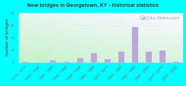
- New bridges - historical statistics
- 11910-1919
- 21930-1939
- 11940-1949
- 41950-1959
- 81960-1969
- 31970-1979
- 91980-1989
- 291990-1999
- 92000-2009
- 102010-2019
- 12020-2022


- Bridge Condition - Deck
- 8.5%Very good
- 46.8%Good
- 40.4%Satisfactory
- 2.1%Fair
- 2.1%Failed

- Bridge Condition - Superstructure
- 2.1%Excellent
- 17.0%Very good
- 34.0%Good
- 25.5%Satisfactory
- 17.0%Fair
- 2.1%Poor
- 2.1%Failed

- Bridge Condition - Substructure
- 4.3%Very good
- 36.2%Good
- 38.3%Satisfactory
- 17.0%Fair
- 2.1%Poor
- 2.1%Failed

- Bridge Condition - Channel
- 4.4%Very good
- 44.4%Good
- 37.8%Satisfactory
- 11.1%Fair
- 2.2%Failed

- Bridge Condition - Culverts
- 25.0%Good
- 75.0%Satisfactory
Find on map >> Show street view
Structure Number: 105B00010L, Location: .6 MI E OF E-JCT US 460 (Lat: 38.225278, Lng: -84.538333), Route carried "on" structure: US 62, Year Built: 1962, Status: Open, Structure Length: 10.92m (35.83ft), Average Daily Traffic: 11,477 (year 2019), Truck Traffic: 9%, Average Future Daily Traffic: 10,788 (year 2039), Design Load: HS 20, Features Intersected: I-75
Minimum Vertical Clearance: 30+ m (98+ ft), Kilometerpoint: 18.231, Lanes on structure: 2, Lanes under structure: 6, Base Highway Network: Yes, Owner: State Highway Agency, Approaching Roadway Width: 10.6m (34.8ft), Skew: 4 degrees, Material/Design: Concrete continuous, Design/Construction: Tee Beam, Number Of Spans In Main Unit: 4, Length of Maximum Span: 29.6m (97.1ft), Curb-To-Curb Width: 10.6m (34.8ft), Out-to-Out Width: 11.1m (36.4ft)
Condition: Deck: Satisfactory, Superstructure: Fair, Substructure: Fair, Operating Rating: 67.1 metric tons, Method Used To Determine Operating Rating: Load Factor (LF), Inventory Rating: 39.9 metric tons, Method Used To Determine Inventory Rating: Load Factor (LF), Structural Evaluation: Somewhat better than minimum adequacy, Deck Geometry: Somewhat better than minimum adequacy, Underclear: Meets minimum limits, Approach Roadway Alignment: Equal to present desirable criteria, Designated Inspection Frequency: Every 24 months, Inspection Date: March 2021, Deck Structure Type: Concrete Cast-file-Place, Wearing Surface/Protective System: Wearing Surface: Monolithic Concrete, Deck Protection: Epoxy Coated Reinforcing
Find on map >> Show street view
Structure Number: 105B00014N, Location: .3 MI W OF E-JCT US 62 (Lat: 38.213056, Lng: -84.545278), Route carried "on" structure: US 460, Year Built: 1934, Year Reconstructed: 1966, Status: Open, Structure Length: 3.44m (11.29ft), Average Daily Traffic: 13,576 (year 2020), Truck Traffic: 8%, Average Future Daily Traffic: 12,625 (year 2040), Design Load: HS 20, Features Intersected: N.FK ELKHORN CREEK
Minimum Vertical Clearance: 30+ m (98+ ft), Kilometerpoint: 16.937, Lanes on structure: 2, Owner: State Highway Agency, Approaching Roadway Width: 7.3m (24.0ft), Material/Design: Concrete, Design/Construction: Tee Beam, Number Of Spans In Main Unit: 3, Length of Maximum Span: 10.5m (34.4ft), Curb or Sidewalk Widths: Left: 0.8m (2.6ft), Right: 0.8m (2.6ft), Curb-To-Curb Width: 9.1m (29.9ft), Out-to-Out Width: 11.3m (37.1ft)
Condition: Deck: Satisfactory, Superstructure: Satisfactory, Substructure: Fair, Channel: Fair, Operating Rating: 62.4 metric tons, Method Used To Determine Operating Rating: Load Factor (LF), Inventory Rating: 37.5 metric tons, Method Used To Determine Inventory Rating: Load Factor (LF), Structural Evaluation: Somewhat better than minimum adequacy, Deck Geometry: High priority of corrective action, Waterway Adequacy: Somewhat better than minimum adequacy, Approach Roadway Alignment: Better than present minimum criteria, Length Of Structure Improvement: 0.34m (1.12ft), Designated Inspection Frequency: Every 24 months, Inspection Date: March 2021, Bridge Improvement Cost: $519,000, Total Project Cost: $519,000, Deck Structure Type: Concrete Cast-file-Place, Wearing Surface/Protective System: Wearing Surface: Bituminous, Membrane: Preformed Fabric
Find on map >> Show street view
Structure Number: 105B00016N, Location: .50 MI EAST OF I-75 NTRCH (Lat: 38.217500, Lng: -84.523889), Route carried "on" structure: US 460, Year Built: 1954, Status: Posted for load, Structure Length: 0.87m (2.85ft), Average Daily Traffic: 12,614 (year 2018), Truck Traffic: 6%, Average Future Daily Traffic: 11,731 (year 2038), Design Load: H 20, Features Intersected: LANES RUN
Minimum Vertical Clearance: 30+ m (98+ ft), Kilometerpoint: 18.899, Lanes on structure: 2, Owner: State Highway Agency, Approaching Roadway Width: 12.9m (42.3ft), Skew: 3 degrees, Material/Design: Concrete, Design/Construction: Culvert, Number Of Spans In Main Unit: 2, Length of Maximum Span: 4.2m (13.8ft)
Condition: Channel: Satisfactory, Culverts: Satisfactory, Operating Rating: 39.0 metric tons, Method Used To Determine Operating Rating: Field evaluation and documented engineering judgment, Inventory Rating: 18.1 metric tons, Method Used To Determine Inventory Rating: Field evaluation and documented engineering judgment, Structural Evaluation: Meets minimum limits, Waterway Adequacy: Equal to present desirable criteria, Approach Roadway Alignment: Better than present minimum criteria, Bridge Posting: Required (Relationship of Operating Rating to Maximum Legal Load: > 39.9% below), Designated Inspection Frequency: Every 24 months, Inspection Date: March 2021
Find on map >> Show street view
Structure Number: 105B00017N, Location: 1.0 MI WEST OF JCT KY 922 (Lat: 38.219722, Lng: -84.501111), Route carried "on" structure: US 460, Year Built: 1954, Status: Posted for load, Structure Length: 0.77m (2.53ft), Average Daily Traffic: 6,118 (year 2019), Truck Traffic: 6%, Average Future Daily Traffic: 5,077 (year 2039), Design Load: H 20, Features Intersected: MILLER BRANCH
Minimum Vertical Clearance: 30+ m (98+ ft), Kilometerpoint: 20.987, Lanes on structure: 2, Base Highway Network: Yes, Owner: State Highway Agency, Approaching Roadway Width: 6.3m (20.7ft), Material/Design: Concrete, Design/Construction: Culvert, Number Of Spans In Main Unit: 2, Length of Maximum Span: 3.7m (12.1ft)
Condition: Channel: Satisfactory, Culverts: Satisfactory, Operating Rating: 39.0 metric tons, Method Used To Determine Operating Rating: Field evaluation and documented engineering judgment, Inventory Rating: 18.1 metric tons, Method Used To Determine Inventory Rating: Field evaluation and documented engineering judgment, Structural Evaluation: Meets minimum limits, Waterway Adequacy: Better than present minimum criteria, Approach Roadway Alignment: Better than present minimum criteria, Bridge Posting: Required (Relationship of Operating Rating to Maximum Legal Load: > 39.9% below), Designated Inspection Frequency: Every 24 months, Inspection Date: March 2021
Find on map >> Show street view
Structure Number: 105B00021N, Location: .20 MI WEST OF JCT KY 227 (Lat: 38.210000, Lng: -84.610833), Route carried "on" structure: US 460, Year Built: 1940, Status: Posted for load, Structure Length: 1.62m (5.31ft), Average Daily Traffic: 6,060 (year 2019), Truck Traffic: 6%, Average Future Daily Traffic: 5,029 (year 2039), Design Load: H 15, Features Intersected: CANE RUN CREEK
Minimum Vertical Clearance: 30+ m (98+ ft), Kilometerpoint: 10.908, Lanes on structure: 2, Base Highway Network: Yes, Owner: State Highway Agency, Approaching Roadway Width: 8.8m (28.9ft), Material/Design: Concrete, Design/Construction: Tee Beam, Number Of Spans In Main Unit: 1, Length of Maximum Span: 15.2m (49.9ft), Curb-To-Curb Width: 8.8m (28.9ft), Out-to-Out Width: 9.7m (31.8ft)
Condition: Deck: Good, Superstructure: Fair, Substructure: Satisfactory, Channel: Good, Operating Rating: 45.7 metric tons, Method Used To Determine Operating Rating: Load Factor (LF), Inventory Rating: 27.5 metric tons, Method Used To Determine Inventory Rating: Load Factor (LF), Structural Evaluation: Somewhat better than minimum adequacy, Deck Geometry: High priority of replacement, Waterway Adequacy: Better than present minimum criteria, Approach Roadway Alignment: Better than present minimum criteria, Bridge Posting: Required (Relationship of Operating Rating to Maximum Legal Load: 20.0 - 29.9% below), Designated Inspection Frequency: Every 24 months, Inspection Date: March 2021, Deck Structure Type: Concrete Cast-file-Place, Wearing Surface/Protective System: Wearing Surface: Monolithic Concrete, Deck Protection: Epoxy Coated Reinforcing
Find on map >> Show street view
Structure Number: 105B00024N, Location: 2.0 MI S OF JCT KY 620 (Lat: 38.308056, Lng: -84.503889), Route carried "on" structure: State highway 922, Year Built: 1970, Status: Posted for load, Structure Length: 1.34m (4.40ft), Average Daily Traffic: 156 (year 2018), Average Future Daily Traffic: 137 (year 2038), Design Load: H 20, Features Intersected: MUDDY FORD CREEK
Minimum Vertical Clearance: 30+ m (98+ ft), Kilometerpoint: 15.379, Lanes on structure: 2, Owner: State Highway Agency, Approaching Roadway Width: 5.9m (19.4ft), Material/Design: Prestressed concrete, Design/Construction: Box Beam or Girders - Multiple, Number Of Spans In Main Unit: 1, Length of Maximum Span: 12.5m (41.0ft), Curb-To-Curb Width: 6.9m (22.6ft), Out-to-Out Width: 7.4m (24.3ft)
Condition: Deck: Good, Superstructure: Fair, Substructure: Satisfactory, Channel: Fair, Operating Rating: 37.5 metric tons, Method Used To Determine Operating Rating: Field evaluation and documented engineering judgment, Inventory Rating: 22.5 metric tons, Method Used To Determine Inventory Rating: Field evaluation and documented engineering judgment, Structural Evaluation: Somewhat better than minimum adequacy, Deck Geometry: Meets minimum limits, Waterway Adequacy: Better than present minimum criteria, Approach Roadway Alignment: Somewhat better than minimum adequacy, Bridge Posting: Required (Relationship of Operating Rating to Maximum Legal Load: 30.0 - 39.9% below), Designated Inspection Frequency: Every 24 months, Inspection Date: March 2021, Deck Structure Type: Concrete Precast Panels, Wearing Surface/Protective System: Wearing Surface: Bituminous, Membrane: Preformed Fabric
Find on map >> Show street view
Structure Number: 105B00050N, Location: 1.2 MI S OF JCT US 62 (Lat: 38.251111, Lng: -84.494722), Route carried "on" structure: State highway 922, Year Built: 1951, Status: Open, Structure Length: 1.02m (3.35ft), Average Daily Traffic: 1,673 (year 2020), Average Future Daily Traffic: 1,472 (year 2040), Design Load: H 15, Features Intersected: MILLER BRANCH
Minimum Vertical Clearance: 30+ m (98+ ft), Kilometerpoint: 8.834, Lanes on structure: 2, Owner: State Highway Agency, Approaching Roadway Width: 6.1m (20.0ft), Skew: 3 degrees, Material/Design: Concrete, Design/Construction: Culvert, Number Of Spans In Main Unit: 2, Length of Maximum Span: 4.9m (16.1ft)
Condition: Channel: Satisfactory, Culverts: Good, Operating Rating: 54.4 metric tons, Method Used To Determine Operating Rating: Field evaluation and documented engineering judgment, Inventory Rating: 39.9 metric tons, Method Used To Determine Inventory Rating: Field evaluation and documented engineering judgment, Structural Evaluation: Better than present minimum criteria, Waterway Adequacy: Better than present minimum criteria, Approach Roadway Alignment: Better than present minimum criteria, Designated Inspection Frequency: Every 24 months, Inspection Date: March 2021
Find on map >> Show street view
Structure Number: 105B00066N, Location: .07 MI SOU OF KY 620 NTRC (Lat: 38.263611, Lng: -84.552778), Route carried "on" structure: Interstate 75, Year Built: 1962, Status: Open, Structure Length: 0.70m (2.30ft), Average Daily Traffic: 51,753 (year 2016), Truck Traffic: 18%, Average Future Daily Traffic: 55,375 (year 2036), Design Load: HS 20, Features Intersected: FK OF DRY RUN
Minimum Vertical Clearance: 30+ m (98+ ft), Kilometerpoint: 206.455, Lanes on structure: 6, Base Highway Network: Yes, Owner: State Highway Agency, Approaching Roadway Width: 19.3m (63.3ft), Skew: 33 degrees, Material/Design: Concrete, Design/Construction: Culvert, Number Of Spans In Main Unit: 1, Length of Maximum Span: 7.0m (23.0ft)
Condition: Channel: Satisfactory, Culverts: Satisfactory, Operating Rating: 99.8 metric tons, Method Used To Determine Operating Rating: Load Factor (LF), Inventory Rating: 99.8 metric tons, Method Used To Determine Inventory Rating: Load Factor (LF), Structural Evaluation: Equal to present minimum criteria, Waterway Adequacy: Equal to present desirable criteria, Approach Roadway Alignment: Equal to present desirable criteria, Designated Inspection Frequency: Every 24 months, Inspection Date: March 2021
Find on map >> Show street view
Structure Number: 105B00072N, Location: .1 MI E OF JCT KY 1963 (Lat: 38.193611, Lng: -84.524722), Route carried "on" structure: State highway 1962, Year Built: 1963, Status: Posted for load, Structure Length: 8.38m (27.49ft), Average Daily Traffic: 1,184 (year 2019), Average Future Daily Traffic: 1,041 (year 2039), Design Load: H 20, Features Intersected: I 75
Minimum Vertical Clearance: 30+ m (98+ ft), Kilometerpoint: 1.357, Lanes on structure: 2, Lanes under structure: 6, Owner: State Highway Agency, Approaching Roadway Width: 8.0m (26.2ft), Skew: 2 degrees, Material/Design: Concrete continuous, Design/Construction: Tee Beam, Number Of Spans In Main Unit: 4, Length of Maximum Span: 22.9m (75.1ft), Curb or Sidewalk Widths: Left: 0.6m (2.0ft), Right: 0.6m (2.0ft), Curb-To-Curb Width: 7.9m (25.9ft), Out-to-Out Width: 9.8m (32.2ft)
Condition: Deck: Good, Superstructure: Satisfactory, Substructure: Fair, Operating Rating: 45.2 metric tons, Method Used To Determine Operating Rating: Load Factor (LF), Inventory Rating: 27.1 metric tons, Method Used To Determine Inventory Rating: Load Factor (LF), Structural Evaluation: Somewhat better than minimum adequacy, Deck Geometry: Meets minimum limits, Underclear: Meets minimum limits, Approach Roadway Alignment: Equal to present desirable criteria, Bridge Posting: Required (Relationship of Operating Rating to Maximum Legal Load: 20.0 - 29.9% below), Designated Inspection Frequency: Every 24 months, Inspection Date: March 2021, Deck Structure Type: Concrete Cast-file-Place, Wearing Surface/Protective System: Wearing Surface: Latex Concrete
Find on map >> Show street view
Structure Number: 105B00077L, Location: .4 MI E. OF S. JCT US 25 (Lat: 38.276389, Lng: -84.557500), Route carried "on" structure: State highway 620, Year Built: 1962, Status: Open, Structure Length: 9.02m (29.59ft), Average Daily Traffic: 8,107 (year 2019), Truck Traffic: 8%, Average Future Daily Traffic: 7,539 (year 2039), Design Load: HS 20, Features Intersected: I 75
Minimum Vertical Clearance: 30+ m (98+ ft), Kilometerpoint: 4.521, Lanes on structure: 2, Lanes under structure: 6, Owner: State Highway Agency, Approaching Roadway Width: 10.6m (34.8ft), Skew: 3 degrees, Material/Design: Concrete continuous, Design/Construction: Tee Beam, Number Of Spans In Main Unit: 4, Length of Maximum Span: 24.6m (80.7ft), Curb-To-Curb Width: 10.6m (34.8ft), Out-to-Out Width: 11.1m (36.4ft)
Condition: Deck: Satisfactory, Superstructure: Fair, Substructure: Fair, Operating Rating: 71.2 metric tons, Method Used To Determine Operating Rating: Load Factor (LF), Inventory Rating: 42.7 metric tons, Method Used To Determine Inventory Rating: Load Factor (LF), Structural Evaluation: Somewhat better than minimum adequacy, Deck Geometry: Somewhat better than minimum adequacy, Underclear: Somewhat better than minimum adequacy, Approach Roadway Alignment: Equal to present desirable criteria, Designated Inspection Frequency: Every 24 months, Inspection Date: March 2021, Deck Structure Type: Concrete Cast-file-Place, Wearing Surface/Protective System: Wearing Surface: Monolithic Concrete
Find on map >> Show street view
Structure Number: 105B00104N, Location: 1.9 MI W OF JCT US 25 (Lat: 38.310833, Lng: -84.532500), Route carried "on" structure: State highway 620, Year Built: 1987, Status: Open, Structure Length: 0.97m (3.18ft), Average Daily Traffic: 401 (year 2018), Average Future Daily Traffic: 348 (year 2038), Design Load: HS 20+Mod, Features Intersected: ROGERS GAP CREEK
Minimum Vertical Clearance: 30+ m (98+ ft), Kilometerpoint: 29.676, Lanes on structure: 2, Owner: State Highway Agency, Approaching Roadway Width: 5.8m (19.0ft), Skew: 4 degrees, Material/Design: Concrete, Design/Construction: Culvert, Number Of Spans In Main Unit: 2, Length of Maximum Span: 4.7m (15.4ft)
Condition: Channel: Good, Culverts: Good, Operating Rating: 50.5 metric tons, Method Used To Determine Operating Rating: Load and Resistance Factor Rating (LRFR) rating reported by rating factor(RF) method using HL-93 loadings, Inventory Rating: 38.9 metric tons, Method Used To Determine Inventory Rating: Load and Resistance Factor Rating (LRFR) rating reported by rating factor(RF) method using HL-93 loadings, Structural Evaluation: Better than present minimum criteria, Waterway Adequacy: Equal to present minimum criteria, Approach Roadway Alignment: Better than present minimum criteria, Designated Inspection Frequency: Every 24 months, Inspection Date: March 2021
Find on map >> Show street view
Structure Number: 105B00105N, Location: .4 MI FROM JCT I-75 (Lat: 38.272778, Lng: -84.547500), Route carried "on" structure: State highway 620, Year Built: 1987, Status: Open, Structure Length: 9.14m (29.99ft), Average Daily Traffic: 9,461 (year 2020), Truck Traffic: 18%, Average Future Daily Traffic: 8,893 (year 2040), Design Load: HS 20, Features Intersected: NS (CNO&TP) SYSTEM
Minimum Vertical Clearance: 30+ m (98+ ft), Kilometerpoint: 3.656, Lanes on structure: 4, Base Highway Network: Yes, Owner: State Highway Agency, Approaching Roadway Width: 25.0m (82.0ft), Material/Design: Prestressed concrete continuous, Design/Construction: Stringer/Multi-beam, Number Of Spans In Main Unit: 4, Length of Maximum Span: 29.9m (98.1ft), Curb-To-Curb Width: 25.0m (82.0ft), Out-to-Out Width: 26.0m (85.3ft)
Condition: Deck: Satisfactory, Superstructure: Good, Substructure: Poor, Operating Rating: 65.1 metric tons, Method Used To Determine Operating Rating: Load Factor (LF), Inventory Rating: 39.1 metric tons, Method Used To Determine Inventory Rating: Load Factor (LF), Structural Evaluation: Meets minimum limits, Deck Geometry: Superior to present desirable criteria, Underclear: Somewhat better than minimum adequacy, Approach Roadway Alignment: Better than present minimum criteria, Length Of Structure Improvement: 0.91m (2.99ft), Designated Inspection Frequency: Every 24 months, Inspection Date: March 2021, Bridge Improvement Cost: $3,195,000, Total Project Cost: $3,195,000, Deck Structure Type: Concrete Cast-file-Place, Wearing Surface/Protective System: Wearing Surface: Monolithic Concrete, Deck Protection: Epoxy Coated Reinforcing
Find on map >> Show street view
Structure Number: 105B00106N, Location: .60 MI E OF I-75 INTRCH (Lat: 38.273333, Lng: -84.548611), Route carried "on" structure: State highway 620, Year Built: 1986, Status: Open, Structure Length: 0.78m (2.56ft), Average Daily Traffic: 9,461 (year 2020), Truck Traffic: 18%, Average Future Daily Traffic: 8,893 (year 2040), Design Load: HS 20, Features Intersected: BR OF DRY RUN CREEK
Minimum Vertical Clearance: 30+ m (98+ ft), Kilometerpoint: 3.561, Lanes on structure: 4, Base Highway Network: Yes, Owner: State Highway Agency, Approaching Roadway Width: 25.6m (84.0ft), Skew: 1 degrees, Material/Design: Concrete, Design/Construction: Culvert, Number Of Spans In Main Unit: 2, Length of Maximum Span: 3.7m (12.1ft)
Condition: Channel: Good, Culverts: Satisfactory, Operating Rating: 99.8 metric tons, Method Used To Determine Operating Rating: Field evaluation and documented engineering judgment, Inventory Rating: 99.8 metric tons, Method Used To Determine Inventory Rating: Field evaluation and documented engineering judgment, Structural Evaluation: Equal to present minimum criteria, Waterway Adequacy: Equal to present desirable criteria, Approach Roadway Alignment: Equal to present desirable criteria, Designated Inspection Frequency: Every 24 months, Inspection Date: March 2021
Find on map >> Show street view
Structure Number: 105B00107R, Location: .4 MI E OF S.JCT US 25 (Lat: 38.276389, Lng: -84.557500), Route carried "on" structure: State highway 620, Year Built: 1987, Status: Posted for load, Structure Length: 9.02m (29.59ft), Average Daily Traffic: 8,107 (year 2019), Truck Traffic: 8%, Average Future Daily Traffic: 7,539 (year 2039), Design Load: HS 20, Features Intersected: I-75
Minimum Vertical Clearance: 30+ m (98+ ft), Kilometerpoint: 4.521, Lanes on structure: 2, Lanes under structure: 6, Owner: State Highway Agency, Approaching Roadway Width: 14.3m (46.9ft), Skew: 3 degrees, Material/Design: Prestressed concrete continuous, Design/Construction: Stringer/Multi-beam, Number Of Spans In Main Unit: 4, Length of Maximum Span: 24.6m (80.7ft), Curb-To-Curb Width: 14.3m (46.9ft), Out-to-Out Width: 14.8m (48.6ft)
Condition: Deck: Satisfactory, Superstructure: Fair, Substructure: Satisfactory, Operating Rating: 59.0 metric tons, Method Used To Determine Operating Rating: Load Factor (LF), Inventory Rating: 35.4 metric tons, Method Used To Determine Inventory Rating: Load Factor (LF), Structural Evaluation: Somewhat better than minimum adequacy, Deck Geometry: Superior to present desirable criteria, Underclear: Somewhat better than minimum adequacy, Approach Roadway Alignment: Equal to present desirable criteria, Designated Inspection Frequency: Every 24 months, Inspection Date: March 2021, Deck Structure Type: Concrete Cast-file-Place, Wearing Surface/Protective System: Wearing Surface: Monolithic Concrete
Find on map >> Show street view
Structure Number: 105B00108R, Location: .6 MI E OF E-JCT US 460 (Lat: 38.225000, Lng: -84.538333), Route carried "on" structure: US 62, Year Built: 1988, Status: Open, Structure Length: 10.92m (35.83ft), Average Daily Traffic: 11,477 (year 2019), Truck Traffic: 9%, Average Future Daily Traffic: 10,788 (year 2039), Design Load: HS 20, Features Intersected: I-75, Facility Carried by Structure: CYNTHIANA ROAD
Minimum Vertical Clearance: 30+ m (98+ ft), Kilometerpoint: 18.221, Lanes on structure: 2, Lanes under structure: 6, Base Highway Network: Yes, Owner: State Highway Agency, Approaching Roadway Width: 18.6m (61.0ft), Skew: 4 degrees, Material/Design: Prestressed concrete continuous, Design/Construction: Stringer/Multi-beam, Number Of Spans In Main Unit: 4, Length of Maximum Span: 29.6m (97.1ft), Curb-To-Curb Width: 18.7m (61.4ft), Out-to-Out Width: 19.2m (63.0ft)
Condition: Deck: Satisfactory, Superstructure: Fair, Substructure: Fair, Operating Rating: 65.0 metric tons, Method Used To Determine Operating Rating: Load Factor (LF), Inventory Rating: 39.0 metric tons, Method Used To Determine Inventory Rating: Load Factor (LF), Structural Evaluation: Somewhat better than minimum adequacy, Deck Geometry: Superior to present desirable criteria, Underclear: Meets minimum limits, Approach Roadway Alignment: Equal to present desirable criteria, Designated Inspection Frequency: Every 24 months, Inspection Date: March 2021, Deck Structure Type: Concrete Cast-file-Place, Wearing Surface/Protective System: Wearing Surface: Monolithic Concrete, Deck Protection: Epoxy Coated Reinforcing
Find on map >> Show street view
Structure Number: 105B00109N, Location: .1 mi west of Oxford Dr (Lat: 38.252500, Lng: -84.525556), Route carried "on" structure: US 62, Year Built: 1988, Status: Open, Structure Length: 0.76m (2.49ft), Average Daily Traffic: 8,078 (year 2018), Truck Traffic: 9%, Average Future Daily Traffic: 7,512 (year 2038), Design Load: HS 20, Features Intersected: LANES RUN, Facility Carried by Structure: CYNTHIANA ROAD
Minimum Vertical Clearance: 30+ m (98+ ft), Kilometerpoint: 21.541, Lanes on structure: 4, Owner: State Highway Agency, Approaching Roadway Width: 19.5m (64.0ft), Skew: 1 degrees, Material/Design: Concrete, Design/Construction: Culvert, Number Of Spans In Main Unit: 2, Length of Maximum Span: 3.6m (11.8ft)
Condition: Channel: Satisfactory, Culverts: Satisfactory, Operating Rating: 60.1 metric tons, Method Used To Determine Operating Rating: Load Factor (LF), Inventory Rating: 35.9 metric tons, Method Used To Determine Inventory Rating: Load Factor (LF), Structural Evaluation: Equal to present minimum criteria, Waterway Adequacy: Equal to present desirable criteria, Approach Roadway Alignment: Equal to present desirable criteria, Designated Inspection Frequency: Every 24 months, Inspection Date: March 2021
Find on map >> Show street view
Structure Number: 105B00116L, Location: S. SE JCT US 62 (Lat: 38.211111, Lng: -84.539444), Route carried "on" structure: US 62, Year Built: 1992, Status: Open, Structure Length: 8.63m (28.31ft), Average Daily Traffic: 11,816 (year 2018), Truck Traffic: 7%, Average Future Daily Traffic: 11,107 (year 2038), Design Load: HS 25 or greater, Features Intersected: ELKHORN CREEK
Minimum Vertical Clearance: 30+ m (98+ ft), Kilometerpoint: 16.625, Lanes on structure: 2, Base Highway Network: Yes, Owner: State Highway Agency, Approaching Roadway Width: 11.6m (38.1ft), Skew: 3 degrees, Material/Design: Prestressed concrete continuous, Design/Construction: Stringer/Multi-beam, Number Of Spans In Main Unit: 3, Length of Maximum Span: 29.1m (95.5ft), Curb-To-Curb Width: 12.2m (40.0ft), Out-to-Out Width: 13.2m (43.3ft)
Condition: Deck: Satisfactory, Superstructure: Good, Substructure: Satisfactory, Channel: Good, Operating Rating: 87.8 metric tons, Method Used To Determine Operating Rating: Load Factor (LF), Inventory Rating: 52.7 metric tons, Method Used To Determine Inventory Rating: Load Factor (LF), Structural Evaluation: Equal to present minimum criteria, Deck Geometry: Better than present minimum criteria, Waterway Adequacy: Equal to present desirable criteria, Approach Roadway Alignment: Equal to present desirable criteria, Designated Inspection Frequency: Every 24 months, Inspection Date: March 2021, Deck Structure Type: Concrete Cast-file-Place, Wearing Surface/Protective System: Wearing Surface: Monolithic Concrete, Deck Protection: Epoxy Coated Reinforcing
Find on map >> Show street view
Structure Number: 105B00116R, Location: S. SE JCT US 62 (Lat: 38.211111, Lng: -84.539167), Route carried "on" structure: US 62, Year Built: 1992, Status: Open, Structure Length: 8.63m (28.31ft), Average Daily Traffic: 11,816 (year 2018), Truck Traffic: 7%, Average Future Daily Traffic: 11,107 (year 2038), Design Load: HS 25 or greater, Features Intersected: ELKHORN CREEK, Facility Carried by Structure: MCCLELLAND CIRCLE
Minimum Vertical Clearance: 30+ m (98+ ft), Kilometerpoint: 16.631, Lanes on structure: 2, Base Highway Network: Yes, Owner: State Highway Agency, Approaching Roadway Width: 11.6m (38.1ft), Skew: 3 degrees, Material/Design: Prestressed concrete continuous, Design/Construction: Stringer/Multi-beam, Number Of Spans In Main Unit: 3, Length of Maximum Span: 29.1m (95.5ft), Curb-To-Curb Width: 12.2m (40.0ft), Out-to-Out Width: 13.2m (43.3ft)
Condition: Deck: Satisfactory, Superstructure: Good, Substructure: Good, Channel: Good, Operating Rating: 87.8 metric tons, Method Used To Determine Operating Rating: Load Factor (LF), Inventory Rating: 52.7 metric tons, Method Used To Determine Inventory Rating: Load Factor (LF), Structural Evaluation: Better than present minimum criteria, Deck Geometry: Better than present minimum criteria, Waterway Adequacy: Equal to present desirable criteria, Approach Roadway Alignment: Equal to present desirable criteria, Designated Inspection Frequency: Every 24 months, Inspection Date: March 2021, Deck Structure Type: Concrete Cast-file-Place, Wearing Surface/Protective System: Wearing Surface: Monolithic Concrete, Deck Protection: Epoxy Coated Reinforcing
Find on map >> Show street view
Structure Number: 105B00117L, Location: NE JCT US 25 (Lat: 38.188333, Lng: -84.545000), Route carried "on" structure: US 62, Year Built: 1992, Status: Open, Structure Length: 6.64m (21.78ft), Average Daily Traffic: 9,619 (year 2020), Truck Traffic: 7%, Average Future Daily Traffic: 9,042 (year 2040), Design Load: HS 25 or greater, Features Intersected: NS (CNO&TP) SYSTEM, Facility Carried by Structure: MCCLELLAND CIRCLE
Minimum Vertical Clearance: 30+ m (98+ ft), Kilometerpoint: 13.926, Lanes on structure: 2, Base Highway Network: Yes, Owner: State Highway Agency, Approaching Roadway Width: 13.0m (42.7ft), Skew: 2 degrees, Material/Design: Prestressed concrete continuous, Design/Construction: Stringer/Multi-beam, Number Of Spans In Main Unit: 3, Length of Maximum Span: 24.7m (81.0ft), Curb-To-Curb Width: 13.0m (42.7ft), Out-to-Out Width: 14.0m (45.9ft)
Condition: Deck: Satisfactory, Superstructure: Satisfactory, Substructure: Good, Operating Rating: 75.9 metric tons, Method Used To Determine Operating Rating: Load Factor (LF), Inventory Rating: 45.5 metric tons, Method Used To Determine Inventory Rating: Load Factor (LF), Structural Evaluation: Equal to present minimum criteria, Deck Geometry: Superior to present desirable criteria, Underclear: Meets minimum limits, Approach Roadway Alignment: Equal to present desirable criteria, Length Of Structure Improvement: 0.66m (2.17ft), Designated Inspection Frequency: Every 24 months, Inspection Date: March 2021, Bridge Improvement Cost: $1,245,000, Total Project Cost: $1,245,000, Deck Structure Type: Concrete Cast-file-Place, Wearing Surface/Protective System: Wearing Surface: Latex Concrete, Deck Protection: Epoxy Coated Reinforcing
Find on map >> Show street view
Structure Number: 105B00117R, Location: NE JCT US 25 (Lat: 38.188056, Lng: -84.545000), Route carried "on" structure: US 62, Year Built: 1992, Status: Open, Structure Length: 6.64m (21.78ft), Average Daily Traffic: 9,619 (year 2020), Truck Traffic: 7%, Average Future Daily Traffic: 9,042 (year 2040), Design Load: HS 25 or greater, Features Intersected: NS (CNO&TP) SYSTEM, Facility Carried by Structure: MCCLELLAND CIRCLE
Minimum Vertical Clearance: 30+ m (98+ ft), Kilometerpoint: 13.918, Lanes on structure: 2, Base Highway Network: Yes, Owner: State Highway Agency, Approaching Roadway Width: 13.0m (42.7ft), Skew: 2 degrees, Material/Design: Prestressed concrete continuous, Design/Construction: Stringer/Multi-beam, Number Of Spans In Main Unit: 3, Length of Maximum Span: 24.7m (81.0ft), Curb-To-Curb Width: 13.0m (42.7ft), Out-to-Out Width: 14.0m (45.9ft)
Condition: Deck: Satisfactory, Superstructure: Satisfactory, Substructure: Good, Operating Rating: 75.9 metric tons, Method Used To Determine Operating Rating: Load Factor (LF), Inventory Rating: 45.5 metric tons, Method Used To Determine Inventory Rating: Load Factor (LF), Structural Evaluation: Equal to present minimum criteria, Deck Geometry: Superior to present desirable criteria, Underclear: Meets minimum limits, Approach Roadway Alignment: Equal to present desirable criteria, Length Of Structure Improvement: 0.66m (2.17ft), Designated Inspection Frequency: Every 24 months, Inspection Date: March 2021, Bridge Improvement Cost: $1,245,000, Total Project Cost: $1,245,000, Deck Structure Type: Concrete Cast-file-Place, Wearing Surface/Protective System: Wearing Surface: Monolithic Concrete, Deck Protection: Epoxy Coated Reinforcing
Find on map >> Show street view
Structure Number: 105B00119L, Location: .9 MI S -US 460 @ GTOWN (Lat: 38.202778, Lng: -84.528889), Route carried "on" structure: Interstate 75, Year Built: 1992, Status: Open, Structure Length: 1.71m (5.61ft), Average Daily Traffic: 28,081 (year 2020), Truck Traffic: 18%, Average Future Daily Traffic: 34,258 (year 2040), Design Load: HS 25 or greater, Features Intersected: E MAIN ST EXT
Minimum Vertical Clearance: 4.59m (15.06ft), Kilometerpoint: 199.403, Lanes on structure: 3, Lanes under structure: 2, Base Highway Network: Yes, Owner: State Highway Agency, Approaching Roadway Width: 18.3m (60.0ft), Material/Design: Prestressed concrete, Design/Construction: Stringer/Multi-beam, Number Of Spans In Main Unit: 1, Length of Maximum Span: 15.2m (49.9ft), Curb-To-Curb Width: 18.3m (60.0ft), Out-to-Out Width: 19.2m (63.0ft)
Condition: Deck: Good, Superstructure: Good, Substructure: Good, Operating Rating: 96.5 metric tons, Method Used To Determine Operating Rating: Load Factor (LF), Inventory Rating: 57.9 metric tons, Method Used To Determine Inventory Rating: Load Factor (LF), Structural Evaluation: Better than present minimum criteria, Deck Geometry: Better than present minimum criteria, Underclear: Somewhat better than minimum adequacy, Approach Roadway Alignment: Equal to present desirable criteria, Length Of Structure Improvement: 0.17m (0.56ft), Designated Inspection Frequency: Every 24 months, Inspection Date: March 2021, Bridge Improvement Cost: $440,000, Total Project Cost: $440,000, Deck Structure Type: Concrete Cast-file-Place, Wearing Surface/Protective System: Wearing Surface: Monolithic Concrete, Deck Protection: Epoxy Coated Reinforcing
Find on map >> Show street view
Structure Number: 105B00119R, Location: .9 MI S-US 460 @ G-TOWN (Lat: 38.202778, Lng: -84.528611), Route carried "on" structure: Interstate 75, Year Built: 1992, Status: Open, Structure Length: 1.71m (5.61ft), Average Daily Traffic: 28,081 (year 2020), Truck Traffic: 18%, Average Future Daily Traffic: 34,258 (year 2040), Design Load: HS 25 or greater, Features Intersected: E MAIN ST EXT
Minimum Vertical Clearance: 4.69m (15.39ft), Kilometerpoint: 199.378, Lanes on structure: 3, Lanes under structure: 2, Base Highway Network: Yes, Owner: State Highway Agency, Approaching Roadway Width: 18.3m (60.0ft), Material/Design: Prestressed concrete, Design/Construction: Stringer/Multi-beam, Number Of Spans In Main Unit: 1, Length of Maximum Span: 15.2m (49.9ft), Curb-To-Curb Width: 18.3m (60.0ft), Out-to-Out Width: 19.2m (63.0ft)
Condition: Deck: Good, Superstructure: Good, Substructure: Satisfactory, Operating Rating: 96.5 metric tons, Method Used To Determine Operating Rating: Load Factor (LF), Inventory Rating: 57.9 metric tons, Method Used To Determine Inventory Rating: Load Factor (LF), Structural Evaluation: Equal to present minimum criteria, Deck Geometry: Better than present minimum criteria, Underclear: Somewhat better than minimum adequacy, Approach Roadway Alignment: Equal to present desirable criteria, Length Of Structure Improvement: 0.17m (0.56ft), Designated Inspection Frequency: Every 24 months, Inspection Date: March 2021, Bridge Improvement Cost: $440,000, Total Project Cost: $440,000, Deck Structure Type: Concrete Cast-file-Place, Wearing Surface/Protective System: Wearing Surface: Monolithic Concrete, Deck Protection: Epoxy Coated Reinforcing
Find on map >> Show street view
Structure Number: 105B00120L, Location: .5 MI S US 460 @ G-TOWN (Lat: 38.209167, Lng: -84.531667), Route carried "on" structure: Interstate 75, Year Built: 1992, Status: Open, Structure Length: 8.16m (26.77ft), Average Daily Traffic: 28,081 (year 2020), Truck Traffic: 18%, Average Future Daily Traffic: 34,258 (year 2040), Design Load: HS 25 or greater, Features Intersected: ELKHORN CREEK
Minimum Vertical Clearance: 30+ m (98+ ft), Kilometerpoint: 200.140, Lanes on structure: 3, Base Highway Network: Yes, Owner: State Highway Agency, Approaching Roadway Width: 18.3m (60.0ft), Skew: 4 degrees, Material/Design: Prestressed concrete continuous, Design/Construction: Stringer/Multi-beam, Number Of Spans In Main Unit: 3, Length of Maximum Span: 29.0m (95.1ft), Curb-To-Curb Width: 18.3m (60.0ft), Out-to-Out Width: 19.2m (63.0ft)
Condition: Deck: Satisfactory, Superstructure: Good, Substructure: Satisfactory, Channel: Good, Operating Rating: 94.6 metric tons, Method Used To Determine Operating Rating: Load Factor (LF), Inventory Rating: 56.8 metric tons, Method Used To Determine Inventory Rating: Load Factor (LF), Structural Evaluation: Equal to present minimum criteria, Deck Geometry: Better than present minimum criteria, Waterway Adequacy: Equal to present desirable criteria, Approach Roadway Alignment: Equal to present desirable criteria, Designated Inspection Frequency: Every 24 months, Inspection Date: March 2021, Deck Structure Type: Concrete Cast-file-Place, Wearing Surface/Protective System: Wearing Surface: Monolithic Concrete, Deck Protection: Epoxy Coated Reinforcing
Find on map >> Show street view
Structure Number: 105B00120R, Location: .5 MI S US 460 @ G-TOWN (Lat: 38.209444, Lng: -84.531389), Route carried "on" structure: Interstate 75, Year Built: 1992, Status: Open, Structure Length: 8.16m (26.77ft), Average Daily Traffic: 28,081 (year 2020), Truck Traffic: 18%, Average Future Daily Traffic: 34,258 (year 2040), Design Load: HS 25 or greater, Features Intersected: ELKHORN CREEK
Minimum Vertical Clearance: 30+ m (98+ ft), Kilometerpoint: 200.132, Lanes on structure: 3, Base Highway Network: Yes, Owner: State Highway Agency, Approaching Roadway Width: 18.3m (60.0ft), Skew: 4 degrees, Material/Design: Prestressed concrete continuous, Design/Construction: Stringer/Multi-beam, Number Of Spans In Main Unit: 3, Length of Maximum Span: 29.0m (95.1ft), Curb-To-Curb Width: 18.3m (60.0ft), Out-to-Out Width: 19.2m (63.0ft)
Condition: Deck: Satisfactory, Superstructure: Satisfactory, Substructure: Satisfactory, Channel: Good, Operating Rating: 94.6 metric tons, Method Used To Determine Operating Rating: Load Factor (LF), Inventory Rating: 56.8 metric tons, Method Used To Determine Inventory Rating: Load Factor (LF), Structural Evaluation: Equal to present minimum criteria, Deck Geometry: Better than present minimum criteria, Waterway Adequacy: Equal to present desirable criteria, Approach Roadway Alignment: Equal to present desirable criteria, Designated Inspection Frequency: Every 24 months, Inspection Date: March 2021, Deck Structure Type: Concrete Cast-file-Place, Wearing Surface/Protective System: Wearing Surface: Monolithic Concrete, Deck Protection: Epoxy Coated Reinforcing
Find on map >> Show street view
Structure Number: 105B00121L, Location: .09 MI.S JCT KY 620 NBL (Lat: 38.264444, Lng: -84.553333), Route carried "on" structure: Interstate 75, Year Built: 1994, Status: Open, Structure Length: 9.40m (30.84ft), Average Daily Traffic: 25,877 (year 2016), Truck Traffic: 18%, Average Future Daily Traffic: 27,688 (year 2036), Design Load: H 20, Features Intersected: NS (CNO&TP) SYSTEM
Minimum Vertical Clearance: 30+ m (98+ ft), Kilometerpoint: 206.579, Lanes on structure: 3, Base Highway Network: Yes, Owner: State Highway Agency, Approaching Roadway Width: 19.1m (62.7ft), Skew: 5 degrees, Material/Design: Concrete continuous, Design/Construction: Tee Beam, Number Of Spans In Main Unit: 3, Length of Maximum Span: 36.2m (118.8ft), Curb-To-Curb Width: 19.1m (62.7ft), Out-to-Out Width: 20.0m (65.6ft)
Condition: Deck: Satisfactory, Superstructure: Satisfactory, Substructure: Fair, Operating Rating: 53.1 metric tons, Method Used To Determine Operating Rating: Load Factor (LF), Inventory Rating: 31.8 metric tons, Method Used To Determine Inventory Rating: Load Factor (LF), Structural Evaluation: Somewhat better than minimum adequacy, Deck Geometry: Superior to present desirable criteria, Underclear: Superior to present desirable criteria, Approach Roadway Alignment: Equal to present desirable criteria, Designated Inspection Frequency: Every 24 months, Inspection Date: March 2021, Bridge Improvement Cost: $6,443,000, Total Project Cost: $6,443,000, Deck Structure Type: Concrete Cast-file-Place, Wearing Surface/Protective System: Wearing Surface: Latex Concrete, Deck Protection: Epoxy Coated Reinforcing
Find on map >> Show street view
Structure Number: 105B00121R, Location: .09 MI.S JCT KY 620 SBL (Lat: 38.264722, Lng: -84.553333), Route carried "on" structure: Interstate 75, Year Built: 1994, Status: Open, Structure Length: 9.40m (30.84ft), Average Daily Traffic: 25,877 (year 2016), Truck Traffic: 18%, Average Future Daily Traffic: 27,688 (year 2036), Design Load: H 20, Features Intersected: NS (CNO&TP) SYSTEM
Minimum Vertical Clearance: 30+ m (98+ ft), Kilometerpoint: 206.604, Lanes on structure: 3, Base Highway Network: Yes, Owner: State Highway Agency, Approaching Roadway Width: 19.1m (62.7ft), Skew: 5 degrees, Material/Design: Concrete continuous, Design/Construction: Tee Beam, Number Of Spans In Main Unit: 3, Length of Maximum Span: 36.2m (118.8ft), Curb-To-Curb Width: 19.1m (62.7ft), Out-to-Out Width: 20.0m (65.6ft)
Condition: Deck: Satisfactory, Superstructure: Satisfactory, Substructure: Fair, Operating Rating: 53.1 metric tons, Method Used To Determine Operating Rating: Load Factor (LF), Inventory Rating: 31.8 metric tons, Method Used To Determine Inventory Rating: Load Factor (LF), Structural Evaluation: Somewhat better than minimum adequacy, Deck Geometry: Superior to present desirable criteria, Underclear: Superior to present desirable criteria, Approach Roadway Alignment: Equal to present desirable criteria, Designated Inspection Frequency: Every 24 months, Inspection Date: March 2021, Bridge Improvement Cost: $6,443,000, Total Project Cost: $6,443,000, Deck Structure Type: Concrete Cast-file-Place, Wearing Surface/Protective System: Wearing Surface: Latex Concrete, Deck Protection: Epoxy Coated Reinforcing
Find on map >> Show street view
Structure Number: 105B00122L, Location: 1.8 MI.N JCT KY 620 (Lat: 38.301944, Lng: -84.558889), Route carried "on" structure: Interstate 75, Year Built: 1992, Status: Open, Structure Length: 2.99m (9.81ft), Average Daily Traffic: 19,094 (year 2020), Truck Traffic: 35%, Average Future Daily Traffic: 23,294 (year 2040), Design Load: HS 25 or greater, Features Intersected: KY 620
Minimum Vertical Clearance: 30+ m (98+ ft), Kilometerpoint: 210.839, Lanes on structure: 3, Lanes under structure: 2, Base Highway Network: Yes, Owner: State Highway Agency, Approaching Roadway Width: 18.3m (60.0ft), Material/Design: Prestressed concrete, Design/Construction: Stringer/Multi-beam, Number Of Spans In Main Unit: 1, Length of Maximum Span: 28.3m (92.8ft), Curb-To-Curb Width: 18.3m (60.0ft), Out-to-Out Width: 19.2m (63.0ft)
Condition: Deck: Satisfactory, Superstructure: Good, Substructure: Satisfactory, Operating Rating: 99.8 metric tons, Method Used To Determine Operating Rating: Load Factor (LF), Inventory Rating: 61.1 metric tons, Method Used To Determine Inventory Rating: Load Factor (LF), Structural Evaluation: Equal to present minimum criteria, Deck Geometry: Better than present minimum criteria, Underclear: High priority of corrective action, Approach Roadway Alignment: Equal to present desirable criteria, Length Of Structure Improvement: 0.30m (0.98ft), Designated Inspection Frequency: Every 24 months, Inspection Date: March 2021, Bridge Improvement Cost: $771,000, Total Project Cost: $770,000, Deck Structure Type: Concrete Cast-file-Place, Wearing Surface/Protective System: Wearing Surface: Monolithic Concrete, Deck Protection: Epoxy Coated Reinforcing
Find on map >> Show street view
Structure Number: 105B00122R, Location: 1.8 MI.N JCT KY 620 (Lat: 38.301944, Lng: -84.558611), Route carried "on" structure: Interstate 75, Year Built: 1992, Status: Open, Structure Length: 2.99m (9.81ft), Average Daily Traffic: 19,094 (year 2020), Truck Traffic: 35%, Average Future Daily Traffic: 23,294 (year 2040), Design Load: HS 25 or greater, Features Intersected: KY 620
Minimum Vertical Clearance: 30+ m (98+ ft), Kilometerpoint: 210.819, Lanes on structure: 3, Lanes under structure: 2, Base Highway Network: Yes, Owner: State Highway Agency, Approaching Roadway Width: 18.3m (60.0ft), Material/Design: Prestressed concrete, Design/Construction: Stringer/Multi-beam, Number Of Spans In Main Unit: 1, Length of Maximum Span: 28.3m (92.8ft), Curb-To-Curb Width: 18.3m (60.0ft), Out-to-Out Width: 19.2m (63.0ft)
Condition: Deck: Satisfactory, Superstructure: Good, Substructure: Good, Operating Rating: 99.8 metric tons, Method Used To Determine Operating Rating: Load Factor (LF), Inventory Rating: 61.1 metric tons, Method Used To Determine Inventory Rating: Load Factor (LF), Structural Evaluation: Better than present minimum criteria, Deck Geometry: Better than present minimum criteria, Underclear: High priority of corrective action, Approach Roadway Alignment: Equal to present desirable criteria, Length Of Structure Improvement: 0.30m (0.98ft), Designated Inspection Frequency: Every 24 months, Inspection Date: March 2021, Bridge Improvement Cost: $771,000, Total Project Cost: $770,000, Deck Structure Type: Concrete Cast-file-Place, Wearing Surface/Protective System: Wearing Surface: Monolithic Concrete, Deck Protection: Epoxy Coated Reinforcing
Find on map >> Show street view
Structure Number: 105B00126L, Location: 1.5 MI W US 460 (Lat: 38.189722, Lng: -84.589167), Route carried "on" structure: US 62, Year Built: 1993, Status: Open, Structure Length: 2.35m (7.71ft), Average Daily Traffic: 6,370 (year 2019), Truck Traffic: 11%, Average Future Daily Traffic: 5,605 (year 2039), Design Load: HS 25 or greater, Features Intersected: CANE RUN CREEK
Minimum Vertical Clearance: 30+ m (98+ ft), Kilometerpoint: 8.628, Lanes on structure: 2, Owner: State Highway Agency, Approaching Roadway Width: 11.3m (37.1ft), Skew: 1 degrees, Material/Design: Prestressed concrete, Design/Construction: Stringer/Multi-beam, Number Of Spans In Main Unit: 1, Length of Maximum Span: 22.2m (72.8ft), Curb-To-Curb Width: 12.3m (40.4ft), Out-to-Out Width: 13.2m (43.3ft)
Condition: Deck: Good, Superstructure: Very good, Substructure: Satisfactory, Channel: Satisfactory, Operating Rating: 85.2 metric tons, Method Used To Determine Operating Rating: Load Factor (LF), Inventory Rating: 51.1 metric tons, Method Used To Determine Inventory Rating: Load Factor (LF), Structural Evaluation: Equal to present minimum criteria, Deck Geometry: Better than present minimum criteria, Waterway Adequacy: Better than present minimum criteria, Approach Roadway Alignment: Equal to present desirable criteria, Designated Inspection Frequency: Every 24 months, Inspection Date: March 2021, Deck Structure Type: Concrete Cast-file-Place, Wearing Surface/Protective System: Wearing Surface: Monolithic Concrete, Deck Protection: Epoxy Coated Reinforcing
Find on map >> Show street view
Structure Number: 105B00128N, Location: .8 MI. S. JCT KY 620 (Lat: 38.320556, Lng: -84.506389), Route carried "on" structure: State highway 922, Year Built: 1994, Status: Open, Structure Length: 1.92m (6.30ft), Average Daily Traffic: 156 (year 2018), Average Future Daily Traffic: 137 (year 2038), Design Load: HS 25 or greater, Features Intersected: WEST FORK EAGLE CREEK
Minimum Vertical Clearance: 30+ m (98+ ft), Kilometerpoint: 17.035, Lanes on structure: 2, Owner: State Highway Agency, Approaching Roadway Width: 7.2m (23.6ft), Skew: 3 degrees, Material/Design: Prestressed concrete, Design/Construction: Box Beam or Girders - Multiple, Number Of Spans In Main Unit: 1, Length of Maximum Span: 18.1m (59.4ft), Curb-To-Curb Width: 8.2m (26.9ft), Out-to-Out Width: 8.6m (28.2ft)
Condition: Deck: Satisfactory, Superstructure: Satisfactory, Substructure: Satisfactory, Channel: Satisfactory, Operating Rating: 60.8 metric tons, Method Used To Determine Operating Rating: Load Factor (LF), Inventory Rating: 36.5 metric tons, Method Used To Determine Inventory Rating: Load Factor (LF), Structural Evaluation: Equal to present minimum criteria, Deck Geometry: Somewhat better than minimum adequacy, Waterway Adequacy: Equal to present desirable criteria, Approach Roadway Alignment: Better than present minimum criteria, Designated Inspection Frequency: Every 24 months, Inspection Date: March 2021, Deck Structure Type: Concrete Precast Panels, Wearing Surface/Protective System: Wearing Surface: Monolithic Concrete
Find on map >> Show street view
Structure Number: 105B00130N, Location: .9 MI. S JCT KY 620 (Lat: 38.261389, Lng: -84.566111), Route carried "on" structure: US 25, Year Built: 1996, Status: Open, Structure Length: 1.51m (4.95ft), Average Daily Traffic: 6,537 (year 2018), Truck Traffic: 5%, Average Future Daily Traffic: 5,752 (year 2038), Design Load: HS 25 or greater, Features Intersected: DRY RUN CREEK
Minimum Vertical Clearance: 30+ m (98+ ft), Kilometerpoint: 12.266, Lanes on structure: 2, Owner: State Highway Agency, Approaching Roadway Width: 7.0m (23.0ft), Skew: 4 degrees, Material/Design: Prestressed concrete, Design/Construction: Box Beam or Girders - Single/Spread, Number Of Spans In Main Unit: 1, Length of Maximum Span: 13.0m (42.7ft), Curb-To-Curb Width: 12.4m (40.7ft), Out-to-Out Width: 13.3m (43.6ft)
Condition: Deck: Satisfactory, Superstructure: Very good, Substructure: Satisfactory, Channel: Good, Operating Rating: 87.3 metric tons, Method Used To Determine Operating Rating: Load Factor (LF), Inventory Rating: 52.3 metric tons, Method Used To Determine Inventory Rating: Load Factor (LF), Structural Evaluation: Equal to present minimum criteria, Deck Geometry: Somewhat better than minimum adequacy, Waterway Adequacy: Equal to present desirable criteria, Approach Roadway Alignment: Equal to present desirable criteria, Designated Inspection Frequency: Every 24 months, Inspection Date: March 2021, Deck Structure Type: Concrete Cast-file-Place, Wearing Surface/Protective System: Wearing Surface: Monolithic Concrete, Deck Protection: Epoxy Coated Reinforcing
Find on map >> Show street view
Structure Number: 105B00131N, Location: .7 MI.N. JCT US 62-460 (Lat: 38.218889, Lng: -84.563333), Route carried "on" structure: US 25, Year Built: 1998, Status: Open, Structure Length: 3.99m (13.09ft), Average Daily Traffic: 9,845 (year 2020), Truck Traffic: 11%, Average Future Daily Traffic: 9,155 (year 2040), Design Load: HS 25 or greater, Features Intersected: ELKHORN CREEK
Minimum Vertical Clearance: 30+ m (98+ ft), Kilometerpoint: 7.393, Lanes on structure: 2, Owner: State Highway Agency, Approaching Roadway Width: 11.0m (36.1ft), Material/Design: Prestressed concrete continuous, Design/Construction: Stringer/Multi-beam, Number Of Spans In Main Unit: 2, Length of Maximum Span: 27.0m (88.6ft), Curb or Sidewalk Widths: Left: 1.8m (5.9ft), Right: 1.8m (5.9ft), Curb-To-Curb Width: 12.4m (40.7ft), Out-to-Out Width: 17.0m (55.8ft)
Condition: Deck: Good, Superstructure: Good, Substructure: Good, Channel: Good, Operating Rating: 95.5 metric tons, Method Used To Determine Operating Rating: Load Factor (LF), Inventory Rating: 57.3 metric tons, Method Used To Determine Inventory Rating: Load Factor (LF), Structural Evaluation: Better than present minimum criteria, Deck Geometry: Somewhat better than minimum adequacy, Waterway Adequacy: Better than present minimum criteria, Approach Roadway Alignment: Better than present minimum criteria, Designated Inspection Frequency: Every 24 months, Inspection Date: March 2021, Deck Structure Type: Concrete Cast-file-Place, Wearing Surface/Protective System: Wearing Surface: Monolithic Concrete, Deck Protection: Epoxy Coated Reinforcing
Find on map >> Show street view
Structure Number: 105B00133N, Location: .25 MI. N JCT US 460 (Lat: 38.215556, Lng: -84.605833), Route carried "on" structure: State highway 227, Year Built: 1999, Status: Open, Structure Length: 5.27m (17.29ft), Average Daily Traffic: 4,026 (year 2019), Truck Traffic: 8%, Average Future Daily Traffic: 3,542 (year 2039), Design Load: HS 25 or greater, Features Intersected: NORTH ELKHORN CK
Minimum Vertical Clearance: 30+ m (98+ ft), Kilometerpoint: 0.536, Lanes on structure: 2, Owner: State Highway Agency, Approaching Roadway Width: 6.7m (22.0ft), Material/Design: Prestressed concrete continuous, Design/Construction: Stringer/Multi-beam, Number Of Spans In Main Unit: 2, Length of Maximum Span: 35.1m (115.2ft), Curb-To-Curb Width: 12.1m (39.7ft), Out-to-Out Width: 13.0m (42.7ft)
Condition: Deck: Good, Superstructure: Good, Substructure: Good, Channel: Good, Operating Rating: 92.1 metric tons, Method Used To Determine Operating Rating: Load Factor (LF), Inventory Rating: 55.3 metric tons, Method Used To Determine Inventory Rating: Load Factor (LF), Structural Evaluation: Better than present minimum criteria, Deck Geometry: Somewhat better than minimum adequacy, Waterway Adequacy: Better than present minimum criteria, Approach Roadway Alignment: Somewhat better than minimum adequacy, Designated Inspection Frequency: Every 24 months, Inspection Date: March 2021, Deck Structure Type: Concrete Cast-file-Place, Wearing Surface/Protective System: Wearing Surface: Monolithic Concrete, Deck Protection: Epoxy Coated Reinforcing
Find on map >> Show street view
Structure Number: 105B00136N, Location: 1.0 MI E. JCT KY 922 (Lat: 38.268889, Lng: -84.479722), Route carried "on" structure: US 62, Year Built: 2001, Status: Open, Structure Length: 1.06m (3.48ft), Average Daily Traffic: 8,078 (year 2018), Truck Traffic: 9%, Average Future Daily Traffic: 6,704 (year 2038), Design Load: HS 25 or greater, Features Intersected: MILLERS CREEK
Minimum Vertical Clearance: 30+ m (98+ ft), Kilometerpoint: 26.639, Lanes on structure: 2, Base Highway Network: Yes, Owner: State Highway Agency, Approaching Roadway Width: 13.7m (44.9ft), Skew: 1 degrees, Material/Design: Concrete, Design/Construction: Culvert, Number Of Spans In Main Unit: 3, Length of Maximum Span: 3.0m (9.8ft)
Condition: Channel: Good, Culverts: Satisfactory, Structural Evaluation: Equal to present minimum criteria, Waterway Adequacy: Equal to present desirable criteria, Approach Roadway Alignment: Equal to present desirable criteria, Designated Inspection Frequency: Every 24 months, Inspection Date: March 2021
Find on map >> Show street view
Structure Number: 105B00137N, Location: 1.675 MI S JCT US 25 (Lat: 38.239722, Lng: -84.557500), Route carried "on" structure: State highway 32, Year Built: 2003, Status: Open, Structure Length: 21.25m (69.72ft), Average Daily Traffic: 5,719 (year 2020), Truck Traffic: 5%, Average Future Daily Traffic: 5,318 (year 2040), Design Load: HS 25 or greater, Features Intersected: DRY RUN CREEK & NS RR
Minimum Vertical Clearance: 30+ m (98+ ft), Kilometerpoint: 2.803, Lanes on structure: 2, Owner: State Highway Agency, Approaching Roadway Width: 13.4m (44.0ft), Material/Design: Prestressed concrete continuous, Design/Construction: Stringer/Multi-beam, Number Of Spans In Main Unit: 5, Number Of Approach Spans: 2, Length of Maximum Span: 36.5m (119.8ft), Curb-To-Curb Width: 13.4m (44.0ft), Out-to-Out Width: 14.3m (46.9ft)
Condition: Deck: Very good, Superstructure: Good, Substructure: Satisfactory, Channel: Good, Operating Rating: 72.9 metric tons, Method Used To Determine Operating Rating: Load Factor (LF), Inventory Rating: 43.8 metric tons, Method Used To Determine Inventory Rating: Load Factor (LF), Structural Evaluation: Equal to present minimum criteria, Deck Geometry: Equal to present minimum criteria, Underclear: Better than present minimum criteria, Waterway Adequacy: Superior to present desirable criteria, Approach Roadway Alignment: Equal to present desirable criteria, Designated Inspection Frequency: Every 24 months, Inspection Date: March 2021, Bridge Improvement Cost: $4,704,000, Total Project Cost: $4,704,000, Deck Structure Type: Concrete Cast-file-Place, Wearing Surface/Protective System: Wearing Surface: Monolithic Concrete, Deck Protection: Epoxy Coated Reinforcing
Find on map >> Show street view
Structure Number: 105B00142R, Location: 1.5 MI. W OF US 460B (Lat: 38.189444, Lng: -84.589167), Route carried "on" structure: US 62, Year Built: 2007, Status: Open, Structure Length: 2.35m (7.71ft), Average Daily Traffic: 6,370 (year 2019), Truck Traffic: 11%, Average Future Daily Traffic: 5,605 (year 2039), Design Load: HS 25 or greater, Features Intersected: CANE RUN CREEK
Minimum Vertical Clearance: 30+ m (98+ ft), Kilometerpoint: 8.612, Lanes on structure: 2, Owner: State Highway Agency, Approaching Roadway Width: 11.3m (37.1ft), Material/Design: Prestressed concrete, Design/Construction: Stringer/Multi-beam, Number Of Spans In Main Unit: 1, Length of Maximum Span: 22.4m (73.5ft), Curb-To-Curb Width: 12.7m (41.7ft), Out-to-Out Width: 13.7m (44.9ft)
Condition: Deck: Very good, Superstructure: Very good, Substructure: Satisfactory, Channel: Satisfactory, Operating Rating: 93.9 metric tons, Method Used To Determine Operating Rating: Load Factor (LF), Inventory Rating: 56.3 metric tons, Method Used To Determine Inventory Rating: Load Factor (LF), Structural Evaluation: Equal to present minimum criteria, Deck Geometry: Better than present minimum criteria, Waterway Adequacy: Somewhat better than minimum adequacy, Approach Roadway Alignment: Equal to present desirable criteria, Designated Inspection Frequency: Every 24 months, Inspection Date: March 2021, Deck Structure Type: Concrete Cast-file-Place, Wearing Surface/Protective System: Wearing Surface: Monolithic Concrete, Deck Protection: Epoxy Coated Reinforcing
Find on map >> Show street view
Structure Number: 105B00143N, Location: 0.2 MI E OF E-JCT US 62 (Lat: 38.216111, Lng: -84.534444), Route carried "on" structure: US 460, Year Built: 2003, Status: Open, Structure Length: 7.09m (23.26ft), Average Daily Traffic: 12,614 (year 2018), Truck Traffic: 6%, Average Future Daily Traffic: 11,731 (year 2038), Design Load: HS 25 or greater, Features Intersected: INTERSTATE 75
Minimum Vertical Clearance: 30+ m (98+ ft), Kilometerpoint: 17.943, Lanes on structure: 4, Lanes under structure: 6, Owner: State Highway Agency, Approaching Roadway Width: 29.3m (96.1ft), Material/Design: Prestressed concrete continuous, Design/Construction: Stringer/Multi-beam, Number Of Spans In Main Unit: 2, Length of Maximum Span: 35.1m (115.2ft), Curb-To-Curb Width: 29.3m (96.1ft), Out-to-Out Width: 30.2m (99.1ft)
Condition: Deck: Good, Superstructure: Good, Substructure: Good, Operating Rating: 62.8 metric tons, Method Used To Determine Operating Rating: Load Factor (LF), Inventory Rating: 37.8 metric tons, Method Used To Determine Inventory Rating: Load Factor (LF), Structural Evaluation: Better than present minimum criteria, Deck Geometry: Superior to present desirable criteria, Underclear: Equal to present minimum criteria, Approach Roadway Alignment: Equal to present desirable criteria, Designated Inspection Frequency: Every 24 months, Inspection Date: March 2021, Deck Structure Type: Concrete Cast-file-Place, Wearing Surface/Protective System: Wearing Surface: Monolithic Concrete, Deck Protection: Epoxy Coated Reinforcing
Find on map >> Show street view
Structure Number: 105B00148L, Location: 1 MI N OF FAYETTE CL (Lat: 38.168889, Lng: -84.555556), Route carried "on" structure: US 25, Year Built: 2013, Status: Open, Structure Length: 4.95m (16.24ft), Average Daily Traffic: 8,086 (year 2015), Truck Traffic: 5%, Average Future Daily Traffic: 7,600 (year 2035), Design Load: Greater than HL93, Features Intersected: CANE RUN CREEK
Minimum Vertical Clearance: 30+ m (98+ ft), Kilometerpoint: 1.592, Lanes on structure: 2, Base Highway Network: Yes, Owner: State Highway Agency, Approaching Roadway Width: 11.1m (36.4ft), Skew: 2 degrees, Material/Design: Prestressed concrete continuous, Design/Construction: Stringer/Multi-beam, Number Of Spans In Main Unit: 3, Length of Maximum Span: 22.9m (75.1ft), Curb-To-Curb Width: 11.9m (39.0ft), Out-to-Out Width: 12.7m (41.7ft)
Condition: Deck: Good, Superstructure: Very good, Substructure: Very good, Channel: Good, Operating Rating: 73.5 metric tons, Method Used To Determine Operating Rating: Load and Resistance Factor Rating (LRFR) rating reported by rating factor(RF) method using HL-93 loadings, Inventory Rating: 56.7 metric tons, Method Used To Determine Inventory Rating: Load and Resistance Factor Rating (LRFR) rating reported by rating factor(RF) method using HL-93 loadings, Structural Evaluation: Equal to present desirable criteria, Deck Geometry: Better than present minimum criteria, Waterway Adequacy: Better than present minimum criteria, Approach Roadway Alignment: Equal to present desirable criteria, Designated Inspection Frequency: Every 24 months, Inspection Date: March 2021, Deck Structure Type: Concrete Cast-file-Place, Wearing Surface/Protective System: Wearing Surface: Monolithic Concrete, Deck Protection: Epoxy Coated Reinforcing
Find on map >> Show street view
Structure Number: 105B00148R, Location: 1 MI NOR OF FAYETTE CL (Lat: 38.168889, Lng: -84.555278), Route carried "on" structure: US 25, Year Built: 2013, Status: Open, Structure Length: 4.95m (16.24ft), Average Daily Traffic: 8,086 (year 2015), Truck Traffic: 5%, Average Future Daily Traffic: 7,600 (year 2035), Design Load: Greater than HL93, Features Intersected: CANE RUN CREEK
Minimum Vertical Clearance: 30+ m (98+ ft), Kilometerpoint: 1.587, Lanes on structure: 2, Base Highway Network: Yes, Owner: State Highway Agency, Approaching Roadway Width: 11.2m (36.7ft), Skew: 2 degrees, Material/Design: Prestressed concrete continuous, Design/Construction: Stringer/Multi-beam, Number Of Spans In Main Unit: 3, Length of Maximum Span: 22.9m (75.1ft), Curb-To-Curb Width: 11.9m (39.0ft), Out-to-Out Width: 12.7m (41.7ft)
Condition: Deck: Good, Superstructure: Very good, Substructure: Good, Channel: Good, Operating Rating: 73.5 metric tons, Method Used To Determine Operating Rating: Load and Resistance Factor Rating (LRFR) rating reported by rating factor(RF) method using HL-93 loadings, Inventory Rating: 56.7 metric tons, Method Used To Determine Inventory Rating: Load and Resistance Factor Rating (LRFR) rating reported by rating factor(RF) method using HL-93 loadings, Structural Evaluation: Better than present minimum criteria, Deck Geometry: Better than present minimum criteria, Waterway Adequacy: Superior to present desirable criteria, Approach Roadway Alignment: Equal to present desirable criteria, Designated Inspection Frequency: Every 24 months, Inspection Date: March 2021, Deck Structure Type: Concrete Cast-file-Place, Wearing Surface/Protective System: Wearing Surface: Monolithic Concrete, Deck Protection: Epoxy Coated Reinforcing
Find on map >> Show street view
Structure Number: 105B00149N, Location: 1.2 MILES N OF FAYETTE CO (Lat: 38.172778, Lng: -84.556944), Route carried "on" structure: US 25, Year Built: 2013, Status: Open, Structure Length: 0.70m (2.30ft), Average Daily Traffic: 16,171 (year 2015), Truck Traffic: 5%, Average Future Daily Traffic: 15,200 (year 2035), Design Load: HS 25 or greater, Features Intersected: UNNAMED CREEK
Minimum Vertical Clearance: 30+ m (98+ ft), Kilometerpoint: 2.047, Lanes on structure: 4, Base Highway Network: Yes, Owner: State Highway Agency, Approaching Roadway Width: 24.4m (80.1ft), Skew: 12 degrees, Material/Design: Concrete, Design/Construction: Culvert, Number Of Spans In Main Unit: 2, Length of Maximum Span: 3.6m (11.8ft)
Condition: Channel: Very good, Culverts: Good, Operating Rating: 78.6 metric tons, Method Used To Determine Operating Rating: Load Factor (LF), Inventory Rating: 47.1 metric tons, Method Used To Determine Inventory Rating: Load Factor (LF), Structural Evaluation: Better than present minimum criteria, Waterway Adequacy: Equal to present desirable criteria, Approach Roadway Alignment: Equal to present desirable criteria, Designated Inspection Frequency: Every 24 months, Inspection Date: March 2021
Find on map >> Show street view
Structure Number: 105B00150N, Location: 1.8 MILE S. OF KY 32 (Lat: 38.219167, Lng: -84.593889), Route carried "on" structure: State highway 1143, Year Built: 2015, Status: Open, Structure Length: 16.31m (53.51ft), Average Daily Traffic: 6,803 (year 2020), Truck Traffic: 6%, Average Future Daily Traffic: 6,326 (year 2040), Design Load: Greater than HL93, Features Intersected: NORTH ELKHORN CREEK
Minimum Vertical Clearance: 30+ m (98+ ft), Kilometerpoint: 1.197, Lanes on structure: 2, Owner: State Highway Agency, Approaching Roadway Width: 13.1m (43.0ft), Skew: 1 degrees, Material/Design: Prestressed concrete, Design/Construction: Stringer/Multi-beam, Number Of Spans In Main Unit: 4, Length of Maximum Span: 43.6m (143.0ft), Curb-To-Curb Width: 12.2m (40.0ft), Out-to-Out Width: 13.1m (43.0ft)
Condition: Deck: Good, Superstructure: Good, Substructure: Good, Channel: Good, Operating Rating: 85.9 metric tons, Method Used To Determine Operating Rating: Load and Resistance Factor Rating (LRFR) rating reported by rating factor(RF) method using HL-93 loadings, Inventory Rating: 66.1 metric tons, Method Used To Determine Inventory Rating: Load and Resistance Factor Rating (LRFR) rating reported by rating factor(RF) method using HL-93 loadings, Structural Evaluation: Better than present minimum criteria, Deck Geometry: Somewhat better than minimum adequacy, Waterway Adequacy: Superior to present desirable criteria, Approach Roadway Alignment: Equal to present desirable criteria, Designated Inspection Frequency: Every 24 months, Inspection Date: March 2021, Deck Structure Type: Concrete Cast-file-Place, Wearing Surface/Protective System: Wearing Surface: Monolithic Concrete, Deck Protection: Epoxy Coated Reinforcing