Bridge Statistics for Chantilly, Virginia (VA)
Condition, Traffic, Stress, Structural Evaluation, Project Costs
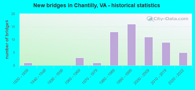
- New bridges - historical statistics
- 11930-1939
- 31960-1969
- 11970-1979
- 131980-1989
- 161990-1999
- 112000-2009
- 92010-2019
- 52020-2022
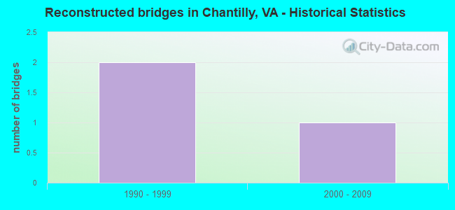
- Reconstructed bridges - Historical Statistics
- 21990-1999
- 12000-2009
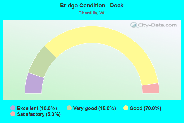
- Bridge Condition - Deck
- 10.0%Excellent
- 15.0%Very good
- 70.0%Good
- 5.0%Satisfactory
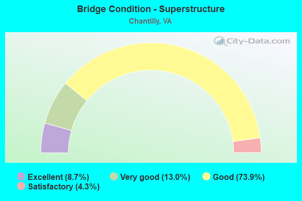
- Bridge Condition - Superstructure
- 8.7%Excellent
- 13.0%Very good
- 73.9%Good
- 4.3%Satisfactory
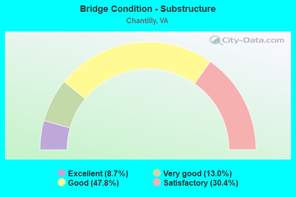
- Bridge Condition - Substructure
- 8.7%Excellent
- 13.0%Very good
- 47.8%Good
- 30.4%Satisfactory
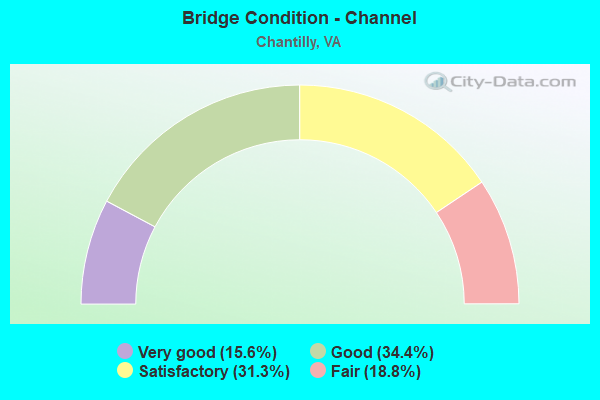
- Bridge Condition - Channel
- 15.6%Very good
- 34.4%Good
- 31.3%Satisfactory
- 18.8%Fair
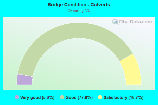
- Bridge Condition - Culverts
- 5.6%Very good
- 77.8%Good
- 16.7%Satisfactory
Find on map >> Show street view
Structure Number: 6264, Location: 00.37 662 / 01.48 50 (Lat: 38.878303, Lng: -77.448792), Route carried "on" structure: State highway 28, Year Built: 1967, Status: Open, Structure Length: 1.46m (4.79ft), Average Daily Traffic: 123,753 (year 2020), Truck Traffic: 3%, Average Future Daily Traffic: 173,254 (year 2040), Design Load: HS 20, Features Intersected: FLAT LICK BRANCH, Facility Carried by Structure: SULLY ROAD
Minimum Vertical Clearance: 30+ m (98+ ft), Kilometerpoint: 53.515, Lanes on structure: 8, Base Highway Network: Yes, Owner: State Highway Agency, Approaching Roadway Width: 18.9m (62.0ft), Skew: 3 degrees, Material/Design: Concrete, Design/Construction: Culvert, Number Of Spans In Main Unit: 4, Length of Maximum Span: 3.7m (12.1ft)
Condition: Channel: Fair, Culverts: Satisfactory, Operating Rating: 89.8 metric tons, Method Used To Determine Operating Rating: Load Factor (LF), Inventory Rating: 59.9 metric tons, Method Used To Determine Inventory Rating: Load Factor (LF), Structural Evaluation: Equal to present minimum criteria, Waterway Adequacy: Equal to present desirable criteria, Approach Roadway Alignment: Equal to present desirable criteria, Length Of Structure Improvement: 29.99m (98.39ft), Designated Inspection Frequency: Every 24 months, Inspection Date: July 2021, Bridge Improvement Cost: $30,000, Roadway Improvement Cost: $66,000, Total Project Cost: $100,000 ( Estimate for 2015)
Find on map >> Show street view
Structure Number: 6267, Location: 0.65mi.Fr 50/1.90mi.To668 (Lat: 38.905111, Lng: -77.433911), Route carried "on" structure: State highway 28, Year Built: 1990, Status: Open, Structure Length: 0.73m (2.40ft), Average Daily Traffic: 105,758 (year 2020), Truck Traffic: 3%, Average Future Daily Traffic: 148,061 (year 2040), Design Load: HS 20, Features Intersected: TRIBUTARY OF CAIN BRANCH, Facility Carried by Structure: SULLY ROAD
Minimum Vertical Clearance: 30+ m (98+ ft), Kilometerpoint: 56.868, Lanes on structure: 7, Base Highway Network: Yes, Owner: State Highway Agency, Approaching Roadway Width: 36.6m (120.1ft), Skew: 3 degrees, Material/Design: Concrete, Design/Construction: Culvert, Number Of Spans In Main Unit: 3, Length of Maximum Span: 2.4m (7.9ft)
Condition: Channel: Satisfactory, Culverts: Satisfactory, Operating Rating: 89.8 metric tons, Method Used To Determine Operating Rating: Load Factor (LF), Inventory Rating: 89.7 metric tons, Method Used To Determine Inventory Rating: Load Factor (LF), Structural Evaluation: Equal to present minimum criteria, Waterway Adequacy: Equal to present desirable criteria, Approach Roadway Alignment: Equal to present desirable criteria, Length Of Structure Improvement: 23.32m (76.51ft), Designated Inspection Frequency: Every 24 months, Inspection Date: April 2021, Bridge Improvement Cost: $55,000, Roadway Improvement Cost: $77,000, Total Project Cost: $150,000
Find on map >> Show street view
Structure Number: 6295, Location: 00.27 657 / 00.21 28 (Lat: 38.896111, Lng: -77.436261), Route carried "on" structure: US 50, Year Built: 1990, Status: Open, Structure Length: 0.82m (2.69ft), Average Daily Traffic: 52,322 (year 2020), Truck Traffic: 2%, Average Future Daily Traffic: 73,251 (year 2040), Design Load: HS 20, Features Intersected: SCHNEIDER BRANCH, Facility Carried by Structure: LEE JACKSON MEM HI
Minimum Vertical Clearance: 30+ m (98+ ft), Kilometerpoint: 102.831, Lanes on structure: 7, Base Highway Network: Yes, Owner: State Highway Agency, Approaching Roadway Width: 33.5m (109.9ft), Skew: 4 degrees, Material/Design: Concrete, Design/Construction: Culvert, Number Of Spans In Main Unit: 3, Length of Maximum Span: 2.7m (8.9ft)
Condition: Channel: Fair, Culverts: Good, Operating Rating: 89.8 metric tons, Method Used To Determine Operating Rating: Field evaluation and documented engineering judgment, Inventory Rating: 58.1 metric tons, Method Used To Determine Inventory Rating: Field evaluation and documented engineering judgment, Structural Evaluation: Better than present minimum criteria, Waterway Adequacy: Equal to present desirable criteria, Approach Roadway Alignment: Better than present minimum criteria, Length Of Structure Improvement: 25.15m (82.51ft), Designated Inspection Frequency: Every 24 months, Inspection Date: June 2021, Bridge Improvement Cost: $66,000, Roadway Improvement Cost: $99,000, Total Project Cost: $175,000 ( Estimate for 2015)
Find on map >> Show street view
Structure Number: 6296, Location: 00.32fr607/00.67to28 (Lat: 38.902269, Lng: -77.451392), Route carried "on" structure: US 50, Year Built: 1969, Status: Open, Structure Length: 1.22m (4.00ft), Average Daily Traffic: 51,398 (year 2020), Truck Traffic: 2%, Average Future Daily Traffic: 71,957 (year 2040), Design Load: HS 20, Features Intersected: CAIN BRANCH, Facility Carried by Structure: LEE-JACKSON HWY.
Minimum Vertical Clearance: 30+ m (98+ ft), Kilometerpoint: 101.351, Lanes on structure: 5, Owner: State Highway Agency, Approaching Roadway Width: 10.4m (34.1ft), Material/Design: Concrete, Design/Construction: Culvert, Number Of Spans In Main Unit: 4, Length of Maximum Span: 2.7m (8.9ft)
Condition: Channel: Satisfactory, Culverts: Good, Operating Rating: 89.8 metric tons, Method Used To Determine Operating Rating: Load Factor (LF), Inventory Rating: 63.5 metric tons, Method Used To Determine Inventory Rating: Load Factor (LF), Structural Evaluation: Better than present minimum criteria, Waterway Adequacy: Equal to present minimum criteria, Approach Roadway Alignment: Equal to present desirable criteria, Length Of Structure Improvement: 10.24m (33.60ft), Designated Inspection Frequency: Every 24 months, Inspection Date: July 2020, Bridge Improvement Cost: $29,000, Roadway Improvement Cost: $59,000, Total Project Cost: $100,000
Find on map >> Show street view
Structure Number: 6708, Location: 00.50FR4955/00.80TO661 (Lat: 38.868089, Lng: -77.463961), Route carried "on" structure: County highway 620, Year Built: 1989, Status: Open, Structure Length: 6.10m (20.01ft), Average Daily Traffic: 6,885 (year 2020), Truck Traffic: 2%, Average Future Daily Traffic: 9,639 (year 2040), Design Load: HS 20, Features Intersected: FLATLICK BRANCH, Facility Carried by Structure: BRADDOCK ROAD
Minimum Vertical Clearance: 30+ m (98+ ft), Kilometerpoint: 3.641, Lanes on structure: 2, Owner: State Highway Agency, Approaching Roadway Width: 9.8m (32.2ft), Material/Design: Concrete continuous, Design/Construction: Slab, Number Of Spans In Main Unit: 4, Length of Maximum Span: 16.8m (55.1ft), Curb or Sidewalk Widths: Left: 0.2m (0.7ft), Right: 0.2m (0.7ft), Curb-To-Curb Width: 13.0m (42.7ft), Out-to-Out Width: 14.0m (45.9ft)
Condition: Deck: Satisfactory, Superstructure: Satisfactory, Substructure: Satisfactory, Channel: Satisfactory, Operating Rating: 44.5 metric tons, Method Used To Determine Operating Rating: Load and Resistance Factor (LRFR), Inventory Rating: 34.5 metric tons, Method Used To Determine Inventory Rating: Load and Resistance Factor (LRFR), Structural Evaluation: Equal to present minimum criteria, Deck Geometry: Somewhat better than minimum adequacy, Waterway Adequacy: Equal to present desirable criteria, Approach Roadway Alignment: Equal to present desirable criteria, Length Of Structure Improvement: 6.10m (20.01ft), Designated Inspection Frequency: Every 24 months, Inspection Date: September 2021, Bridge Improvement Cost: $55,000, Roadway Improvement Cost: $60,000, Total Project Cost: $125,000, Deck Structure Type: Concrete Cast-file-Place, Wearing Surface/Protective System: Wearing Surface: Monolithic Concrete, Deck Protection: Epoxy Coated Reinforcing
Find on map >> Show street view
Structure Number: 6709, Location: 01.49FR.662/00.00TO661 (Lat: 38.875342, Lng: -77.472411), Route carried "on" structure: County highway 620, Year Built: 1974, Status: Open, Structure Length: 1.65m (5.41ft), Average Daily Traffic: 6,885 (year 2020), Truck Traffic: 2%, Average Future Daily Traffic: 9,639 (year 2040), Design Load: HS 20, Features Intersected: CUB RUN, Facility Carried by Structure: BRADDOCK ROAD
Minimum Vertical Clearance: 30+ m (98+ ft), Kilometerpoint: 2.526, Lanes on structure: 2, Owner: State Highway Agency, Approaching Roadway Width: 8.5m (27.9ft), Skew: 1 degrees, Material/Design: Steel, Design/Construction: Stringer/Multi-beam, Number Of Spans In Main Unit: 1, Length of Maximum Span: 16.5m (54.1ft), Curb or Sidewalk Widths: Left: 0.2m (0.7ft), Right: 0.2m (0.7ft), Curb-To-Curb Width: 7.2m (23.6ft), Out-to-Out Width: 7.9m (25.9ft)
Condition: Deck: Very good, Superstructure: Very good, Substructure: Good, Channel: Good, Operating Rating: 65.3 metric tons, Method Used To Determine Operating Rating: Load and Resistance Factor (LRFR), Inventory Rating: 49.9 metric tons, Method Used To Determine Inventory Rating: Load and Resistance Factor (LRFR), Structural Evaluation: Better than present minimum criteria, Deck Geometry: High priority of replacement, Waterway Adequacy: Somewhat better than minimum adequacy, Approach Roadway Alignment: Equal to present minimum criteria, Length Of Structure Improvement: 1.65m (5.41ft), Designated Inspection Frequency: Every 24 months, Inspection Date: July 2020, Bridge Improvement Cost: $120,000, Roadway Improvement Cost: $75,000, Total Project Cost: $200,000 ( Estimate for 2014), Deck Structure Type: Concrete Cast-file-Place, Wearing Surface/Protective System: Deck Protection: Epoxy Coated Reinforcing
Find on map >> Show street view
Structure Number: 68, Location: 00.35FR.28/01.05TO662 (Lat: 38.855278, Lng: -77.429806), Route carried "on" structure: County highway 657, Year Built: 1989, Status: Open, Structure Length: 1.22m (4.00ft), Average Daily Traffic: 3,603 (year 2020), Average Future Daily Traffic: 3,963 (year 2040), Design Load: HS 20, Features Intersected: BIG ROCKY RUN, Facility Carried by Structure: WALNEY ROAD
Minimum Vertical Clearance: 30+ m (98+ ft), Kilometerpoint: 0.547, Lanes on structure: 2, Owner: State Highway Agency, Approaching Roadway Width: 9.1m (29.9ft), Skew: 2 degrees, Material/Design: Prestressed concrete, Design/Construction: Slab, Number Of Spans In Main Unit: 1, Length of Maximum Span: 12.2m (40.0ft), Curb or Sidewalk Widths: Left: 0.2m (0.7ft), Right: 0.2m (0.7ft), Curb-To-Curb Width: 7.5m (24.6ft), Out-to-Out Width: 9.0m (29.5ft)
Condition: Deck: Good, Superstructure: Good, Substructure: Good, Channel: Fair, Operating Rating: 68.7 metric tons, Method Used To Determine Operating Rating: Load and Resistance Factor (LRFR), Inventory Rating: 53.0 metric tons, Method Used To Determine Inventory Rating: Load and Resistance Factor (LRFR), Structural Evaluation: Better than present minimum criteria, Deck Geometry: High priority of replacement, Waterway Adequacy: Somewhat better than minimum adequacy, Approach Roadway Alignment: Somewhat better than minimum adequacy, Length Of Structure Improvement: 1.22m (4.00ft), Designated Inspection Frequency: Every 24 months, Inspection Date: July 2021, Bridge Improvement Cost: $240,000, Roadway Improvement Cost: $24,000, Total Project Cost: $270,000, Deck Structure Type: Concrete Cast-file-Place, Wearing Surface/Protective System: Wearing Surface: Bituminous
Find on map >> Show street view
Structure Number: 6812, Location: 00.50FR8460/00.50TO620 (Lat: 38.882369, Lng: -77.469922), Route carried "on" structure: County highway 661, Year Built: 1932, Year Reconstructed: 1998, Status: Open, Structure Length: 1.31m (4.30ft), Average Daily Traffic: 6,117 (year 2020), Truck Traffic: 2%, Average Future Daily Traffic: 8,564 (year 2040), Design Load: HL 93, Features Intersected: CUB RUN, Facility Carried by Structure: OLD LEE ROAD
Minimum Vertical Clearance: 30+ m (98+ ft), Kilometerpoint: 0.793, Lanes on structure: 2, Owner: State Highway Agency, Approaching Roadway Width: 6.4m (21.0ft), Skew: 1 degrees, Material/Design: Steel, Design/Construction: Stringer/Multi-beam, Number Of Spans In Main Unit: 1, Length of Maximum Span: 13.1m (43.0ft), Curb-To-Curb Width: 7.4m (24.3ft), Out-to-Out Width: 8.4m (27.6ft)
Condition: Deck: Good, Superstructure: Good, Substructure: Good, Channel: Satisfactory, Operating Rating: 87.1 metric tons, Method Used To Determine Operating Rating: Load and Resistance Factor (LRFR), Inventory Rating: 67.1 metric tons, Method Used To Determine Inventory Rating: Load and Resistance Factor (LRFR), Structural Evaluation: Better than present minimum criteria, Deck Geometry: High priority of replacement, Waterway Adequacy: Better than present minimum criteria, Approach Roadway Alignment: Better than present minimum criteria, Length Of Structure Improvement: 1.31m (4.30ft), Designated Inspection Frequency: Every 24 months, Inspection Date: June 2020, Bridge Improvement Cost: $150,000, Roadway Improvement Cost: $15,000, Total Project Cost: $170,000 ( Estimate for 2014), Deck Structure Type: Concrete Cast-file-Place, Wearing Surface/Protective System: Wearing Surface: Monolithic Concrete, Deck Protection: Epoxy Coated Reinforcing
Find on map >> Show street view
Structure Number: 7002, Location: 00.15 4884 / 00.04 4654 (Lat: 38.878667, Lng: -77.422383), Route carried "on" structure: County highway 4646, Year Built: 1967, Status: Open, Structure Length: 0.82m (2.69ft), Average Daily Traffic: 3,048 (year 2020), Truck Traffic: 2%, Average Future Daily Traffic: 3,353 (year 2040), Design Load: HS 20, Features Intersected: FROG BRANCH, Facility Carried by Structure: LEES CORNER ROAD
Minimum Vertical Clearance: 30+ m (98+ ft), Kilometerpoint: 0.483, Lanes on structure: 2, Owner: State Highway Agency, Approaching Roadway Width: 13.4m (44.0ft), Skew: 1 degrees, Material/Design: Steel, Design/Construction: Culvert, Number Of Spans In Main Unit: 2, Length of Maximum Span: 4.0m (13.1ft)
Condition: Channel: Good, Culverts: Good, Operating Rating: 44.5 metric tons, Method Used To Determine Operating Rating: Load Factor (LF), Inventory Rating: 32.7 metric tons, Method Used To Determine Inventory Rating: Load Factor (LF), Structural Evaluation: Better than present minimum criteria, Waterway Adequacy: Better than present minimum criteria, Approach Roadway Alignment: Better than present minimum criteria, Length Of Structure Improvement: 8.29m (27.20ft), Designated Inspection Frequency: Every 24 months, Inspection Date: May 2021, Bridge Improvement Cost: $55,000, Roadway Improvement Cost: $100,000, Total Project Cost: $175,000 ( Estimate for 2015)
Find on map >> Show street view
Structure Number: 7085, Location: 00.20FR7155/00.05TO7140 (Lat: 38.899314, Lng: -77.404369), Route carried "on" structure: County highway 286, Year Built: 1988, Status: Open, Structure Length: 0.98m (3.22ft), Average Daily Traffic: 43,421 (year 2020), Truck Traffic: 1%, Average Future Daily Traffic: 50,633 (year 2040), Design Load: HS 20+Mod, Features Intersected: FLATLICK BRANCH, Facility Carried by Structure: FAIRFAX CO. PKWY.
Minimum Vertical Clearance: 30+ m (98+ ft), Kilometerpoint: 5.728, Lanes on structure: 6, Base Highway Network: Yes, Owner: State Highway Agency, Approaching Roadway Width: 21.3m (69.9ft), Material/Design: Concrete, Design/Construction: Culvert, Number Of Spans In Main Unit: 3, Length of Maximum Span: 3.4m (11.2ft)
Condition: Channel: Good, Culverts: Good, Operating Rating: 89.8 metric tons, Method Used To Determine Operating Rating: Load Factor (LF), Inventory Rating: 89.8 metric tons, Method Used To Determine Inventory Rating: Load Factor (LF), Structural Evaluation: Better than present minimum criteria, Waterway Adequacy: Equal to present desirable criteria, Approach Roadway Alignment: Equal to present desirable criteria, Length Of Structure Improvement: 22.40m (73.49ft), Designated Inspection Frequency: Every 24 months, Inspection Date: Febuary 2021, Bridge Improvement Cost: $44,000, Roadway Improvement Cost: $66,000, Total Project Cost: $150,000
Find on map >> Show street view
Structure Number: 7087, Location: 00.50FR7700/00.43TO50 (Lat: 38.869492, Lng: -77.383075), Route carried "on" structure: County highway 286, Year Built: 1986, Status: Open, Structure Length: 0.64m (2.10ft), Average Daily Traffic: 48,248 (year 2020), Truck Traffic: 1%, Average Future Daily Traffic: 67,547 (year 2040), Design Load: HS 20, Features Intersected: TRIB. BIG ROCKY RUN, Facility Carried by Structure: FAIRFAX CO. PKWY.
Minimum Vertical Clearance: 30+ m (98+ ft), Kilometerpoint: 1.915, Lanes on structure: 8, Base Highway Network: Yes, Owner: State Highway Agency, Approaching Roadway Width: 17.1m (56.1ft), Material/Design: Concrete, Design/Construction: Culvert, Number Of Spans In Main Unit: 2, Length of Maximum Span: 3.0m (9.8ft)
Condition: Channel: Good, Culverts: Good, Operating Rating: 89.8 metric tons, Method Used To Determine Operating Rating: Load Factor (LF), Inventory Rating: 68.0 metric tons, Method Used To Determine Inventory Rating: Load Factor (LF), Structural Evaluation: Better than present minimum criteria, Waterway Adequacy: Better than present minimum criteria, Approach Roadway Alignment: Equal to present desirable criteria, Length Of Structure Improvement: 11.70m (38.39ft), Designated Inspection Frequency: Every 24 months, Inspection Date: Febuary 2021, Bridge Improvement Cost: $38,000, Roadway Improvement Cost: $75,000, Total Project Cost: $125,000
Find on map >> Show street view
Structure Number: 7089, Location: 00.28FR7700/00.35TO66 (Lat: 38.859089, Lng: -77.387350), Route carried "on" structure: County highway 286, Year Built: 1986, Year Reconstructed: 1995, Status: Open, Structure Length: 3.29m (10.79ft), Average Daily Traffic: 55,349 (year 2020), Average Future Daily Traffic: 77,489 (year 2040), Design Load: HS 20, Features Intersected: FAIR LAKES CIRCLE, Facility Carried by Structure: FAIRFAX CO. PKWY.
Minimum Vertical Clearance: 30+ m (98+ ft), Kilometerpoint: 0.032, Lanes on structure: 8, Lanes under structure: 4, Base Highway Network: Yes, Owner: State Highway Agency, Approaching Roadway Width: 19.2m (63.0ft), Skew: 20 degrees, Material/Design: Steel, Design/Construction: Stringer/Multi-beam, Number Of Spans In Main Unit: 1, Length of Maximum Span: 32.9m (107.9ft), Curb-To-Curb Width: 19.5m (64.0ft), Out-to-Out Width: 43.2m (141.7ft)
Condition: Deck: Good, Superstructure: Good, Substructure: Satisfactory, Operating Rating: 38.5 metric tons, Method Used To Determine Operating Rating: Load and Resistance Factor (LRFR), Inventory Rating: 29.7 metric tons, Method Used To Determine Inventory Rating: Load and Resistance Factor (LRFR), Structural Evaluation: Equal to present minimum criteria, Deck Geometry: High priority of replacement, Underclear: Better than present minimum criteria, Approach Roadway Alignment: Equal to present desirable criteria, Length Of Structure Improvement: 3.29m (10.79ft), Designated Inspection Frequency: Every 24 months, Inspection Date: March 2021, Bridge Improvement Cost: $500,000, Roadway Improvement Cost: $50,000, Total Project Cost: $600,000 ( Estimate for 2015), Deck Structure Type: Concrete Cast-file-Place, Wearing Surface/Protective System: Wearing Surface: Monolithic Concrete, Deck Protection: Epoxy Coated Reinforcing
Find on map >> Show street view
Structure Number: 7092, Location: 00.35FR50/00.55TO286 (Lat: 38.889103, Lng: -77.405028), Route carried "on" structure: County highway 7155, Year Built: 1988, Status: Open, Structure Length: 1.16m (3.81ft), Average Daily Traffic: 5,800 (year 2020), Truck Traffic: 2%, Average Future Daily Traffic: 7,178 (year 2040), Design Load: HS 20+Mod, Features Intersected: TRIB. FLATLICK BRANCH., Facility Carried by Structure: STRINGFELLOW RD.
Minimum Vertical Clearance: 30+ m (98+ ft), Kilometerpoint: 0.000, Lanes on structure: 2, Owner: State Highway Agency, Approaching Roadway Width: 11.0m (36.1ft), Material/Design: Concrete, Design/Construction: Culvert, Number Of Spans In Main Unit: 4, Length of Maximum Span: 2.7m (8.9ft)
Condition: Channel: Satisfactory, Culverts: Satisfactory, Operating Rating: 90.6 metric tons, Method Used To Determine Operating Rating: Load Factor (LF), Inventory Rating: 61.7 metric tons, Method Used To Determine Inventory Rating: Load Factor (LF), Structural Evaluation: Equal to present minimum criteria, Waterway Adequacy: Equal to present desirable criteria, Approach Roadway Alignment: Equal to present desirable criteria, Length Of Structure Improvement: 10.36m (33.99ft), Designated Inspection Frequency: Every 24 months, Inspection Date: April 2021, Bridge Improvement Cost: $20,000, Roadway Improvement Cost: $50,000, Total Project Cost: $125,000
Find on map >> Show street view
Structure Number: 7098, Location: 00.08FR7100/00.20TO7701 (Lat: 38.862467, Lng: -77.380975), Route carried "on" structure: County highway 7700, Year Built: 1986, Status: Open, Structure Length: 0.91m (2.99ft), Average Daily Traffic: 17,438 (year 2020), Truck Traffic: 2%, Average Future Daily Traffic: 21,540 (year 2040), Design Load: HS 20, Features Intersected: TRIBUTARY BIG ROCKY RUN, Facility Carried by Structure: FAIR LAKES PARKWAY
Minimum Vertical Clearance: 30+ m (98+ ft), Kilometerpoint: 2.478, Lanes on structure: 6, Base Highway Network: Yes, Owner: State Highway Agency, Approaching Roadway Width: 22.6m (74.1ft), Skew: 3 degrees, Material/Design: Concrete, Design/Construction: Culvert, Number Of Spans In Main Unit: 3, Length of Maximum Span: 3.0m (9.8ft)
Condition: Channel: Good, Culverts: Good, Operating Rating: 89.8 metric tons, Method Used To Determine Operating Rating: Load Factor (LF), Inventory Rating: 89.7 metric tons, Method Used To Determine Inventory Rating: Load Factor (LF), Structural Evaluation: Better than present minimum criteria, Waterway Adequacy: Better than present minimum criteria, Approach Roadway Alignment: Equal to present desirable criteria, Length Of Structure Improvement: 103.70m (340.22ft), Designated Inspection Frequency: Every 24 months, Inspection Date: Febuary 2022, Bridge Improvement Cost: $55,000, Roadway Improvement Cost: $76,000, Total Project Cost: $150,000
Find on map >> Show street view
Structure Number: 7099, Location: 00.55FR7700/00.03TO7700 (Lat: 38.860019, Lng: -77.378697), Route carried "on" structure: County highway 7701, Year Built: 1986, Status: Open, Structure Length: 0.94m (3.08ft), Average Daily Traffic: 9,290 (year 2020), Average Future Daily Traffic: 12,546 (year 2040), Design Load: HS 20, Features Intersected: TRIBUTARY BIG ROCKY RUN, Facility Carried by Structure: FAIR LAKES CIRCLE
Minimum Vertical Clearance: 30+ m (98+ ft), Kilometerpoint: 2.414, Lanes on structure: 5, Owner: State Highway Agency, Approaching Roadway Width: 12.2m (40.0ft), Skew: 10 degrees, Material/Design: Concrete, Design/Construction: Arch - Deck, Number Of Spans In Main Unit: 1, Length of Maximum Span: 8.8m (28.9ft), Curb or Sidewalk Widths: Left: 1.2m (3.9ft), Right: 0.0m, Curb-To-Curb Width: 11.0m (36.1ft), Out-to-Out Width: 35.4m (116.1ft)
Condition: Deck: Good, Superstructure: Good, Substructure: Good, Channel: Satisfactory, Inventory Rating: 82.6 metric tons, Method Used To Determine Inventory Rating: Load and Resistance Factor (LRFR), Structural Evaluation: Better than present minimum criteria, Deck Geometry: High priority of replacement, Waterway Adequacy: Better than present minimum criteria, Approach Roadway Alignment: Better than present minimum criteria, Length Of Structure Improvement: 1.83m (6.00ft), Designated Inspection Frequency: Every 24 months, Inspection Date: Febuary 2021, Bridge Improvement Cost: $13,000, Roadway Improvement Cost: $49,000, Total Project Cost: $75,000, Wearing Surface/Protective System: Membrane: Preformed Fabric
Find on map >> Show street view
Structure Number: 23135, Location: 0.20 fr 50 0.75 to 607 (Lat: 38.904689, Lng: -77.449061), Route carried "on" structure: Business County highway 1279, Year Built: 1987, Status: Open, Structure Length: 1.37m (4.49ft), Average Daily Traffic: 2,000 (year 2003), Truck Traffic: 2%, Average Future Daily Traffic: 5,000 (year 2030), Design Load: HS 20, Features Intersected: Cain Branch, Facility Carried by Structure: Avion Pkwy.
Minimum Vertical Clearance: 30.18m (99.02ft), Kilometerpoint: 0.000, Lanes on structure: 4, Owner: State Highway Agency, Approaching Roadway Width: 8.2m (26.9ft), Skew: 23 degrees, Material/Design: Concrete, Design/Construction: Arch - Deck, Number Of Spans In Main Unit: 1, Length of Maximum Span: 12.2m (40.0ft), Curb or Sidewalk Widths: Left: 2.4m (7.9ft), Right: 2.4m (7.9ft), Curb-To-Curb Width: 7.3m (24.0ft), Out-to-Out Width: 44.5m (146.0ft)
Condition: Superstructure: Good, Substructure: Good, Channel: Very good, Operating Rating: 89.8 metric tons, Method Used To Determine Operating Rating: Load and Resistance Factor (LRFR), Inventory Rating: 71.5 metric tons, Method Used To Determine Inventory Rating: Load and Resistance Factor (LRFR), Structural Evaluation: Better than present minimum criteria, Deck Geometry: High priority of replacement, Waterway Adequacy: Equal to present minimum criteria, Approach Roadway Alignment: Better than present minimum criteria, Designated Inspection Frequency: Every 24 months, Inspection Date: April 2021, Deck Structure Type: Concrete Precast Panels, Wearing Surface/Protective System: Wearing Surface: Latex Concrete
Find on map >> Show street view
Structure Number: 23717, Location: 00.04FR8199 / 00.12TO8198 (Lat: 38.899328, Lng: -77.401600), Route carried "on" structure: County highway 7538, Year Built: 1989, Status: Open, Structure Length: 0.91m (2.99ft), Average Daily Traffic: 588 (year 2002), Average Future Daily Traffic: 700 (year 2040), Design Load: HS 20+Mod, Features Intersected: FLATLICK BRANCH, Facility Carried by Structure: ASHVALE DRIVE
Minimum Vertical Clearance: 30+ m (98+ ft), Kilometerpoint: 0.000, Lanes on structure: 2, Owner: State Highway Agency, Approaching Roadway Width: 9.1m (29.9ft), Material/Design: Concrete, Design/Construction: Culvert, Number Of Spans In Main Unit: 3, Length of Maximum Span: 2.7m (8.9ft), Curb or Sidewalk Widths: Left: 0.0m, Right: 1.2m (3.9ft)
Condition: Channel: Satisfactory, Culverts: Good, Operating Rating: 89.8 metric tons, Method Used To Determine Operating Rating: Load Factor (LF), Inventory Rating: 58.1 metric tons, Method Used To Determine Inventory Rating: Load Factor (LF), Structural Evaluation: Better than present minimum criteria, Waterway Adequacy: Equal to present desirable criteria, Approach Roadway Alignment: Equal to present desirable criteria, Length Of Structure Improvement: 0.30m (0.98ft), Designated Inspection Frequency: Every 24 months, Inspection Date: June 2020, Bridge Improvement Cost: $1,000, Roadway Improvement Cost: $1,000, Total Project Cost: $3,000
Find on map >> Show street view
Structure Number: 23914, Location: 00.75FR50/00.10TO END (Lat: 38.915592, Lng: -77.456897), Route carried "on" structure: County highway 607, Year Built: 1994, Status: Open, Structure Length: 1.71m (5.61ft), Average Daily Traffic: 6,057 (year 2014), Average Future Daily Traffic: 1,871 (year 2035), Design Load: HS 20, Features Intersected: DEAD RUN, Facility Carried by Structure: Stonecroft Blvd.
Minimum Vertical Clearance: 30+ m (98+ ft), Kilometerpoint: 0.998, Lanes on structure: 2, Owner: State Highway Agency, Approaching Roadway Width: 8.5m (27.9ft), Skew: 2 degrees, Material/Design: Concrete, Design/Construction: Culvert, Number Of Spans In Main Unit: 5, Length of Maximum Span: 3.4m (11.2ft)
Condition: Channel: Fair, Culverts: Good, Operating Rating: 89.8 metric tons, Method Used To Determine Operating Rating: Load Factor (LF), Inventory Rating: 59.0 metric tons, Method Used To Determine Inventory Rating: Load Factor (LF), Structural Evaluation: Better than present minimum criteria, Waterway Adequacy: Equal to present desirable criteria, Approach Roadway Alignment: Equal to present desirable criteria, Length Of Structure Improvement: 0.30m (0.98ft), Designated Inspection Frequency: Every 24 months, Inspection Date: July 2020, Bridge Improvement Cost: $1,000, Roadway Improvement Cost: $1,000, Total Project Cost: $3,000
Find on map >> Show street view
Structure Number: 23915, Location: 00.05FR END/00.30TO50 (Lat: 38.899386, Lng: -77.455336), Route carried "on" structure: County highway 8610, Year Built: 1987, Status: Open, Structure Length: 1.95m (6.40ft), Average Daily Traffic: 1,577 (year 2015), Average Future Daily Traffic: 1,774 (year 2040), Design Load: HS 20+Mod, Features Intersected: CAIN BRANCH, Facility Carried by Structure: WESTFAX DRIVE
Minimum Vertical Clearance: 30+ m (98+ ft), Kilometerpoint: 0.370, Lanes on structure: 2, Owner: State Highway Agency, Approaching Roadway Width: 15.8m (51.8ft), Material/Design: Concrete, Design/Construction: Culvert, Number Of Spans In Main Unit: 6, Length of Maximum Span: 3.0m (9.8ft)
Condition: Channel: Good, Culverts: Good, Operating Rating: 89.8 metric tons, Method Used To Determine Operating Rating: Load Factor (LF), Inventory Rating: 59.0 metric tons, Method Used To Determine Inventory Rating: Load Factor (LF), Structural Evaluation: Better than present minimum criteria, Waterway Adequacy: Equal to present desirable criteria, Approach Roadway Alignment: Equal to present desirable criteria, Length Of Structure Improvement: 15.48m (50.79ft), Designated Inspection Frequency: Every 24 months, Inspection Date: May 2020, Bridge Improvement Cost: $35,000, Roadway Improvement Cost: $65,000, Total Project Cost: $125,000
Find on map >> Show street view
Structure Number: 2409, Location: 02.54FR.28/02.16TO50 (Lat: 38.854900, Lng: -77.389019), Route carried "on" structure: Ramp Interstate 66, Year Built: 1994, Status: Open, Structure Length: 5.94m (19.49ft), Average Daily Traffic: 5,800 (year 2002), Truck Traffic: 5%, Average Future Daily Traffic: 11,250 (year 2034), Design Load: HS 20, Features Intersected: FAIRFAX COUNTY PARKWAY
Minimum Vertical Clearance: 30+ m (98+ ft), Kilometerpoint: 0.853, Lanes on structure: 6, Lanes under structure: 8, Base Highway Network: Yes, Owner: State Highway Agency, Approaching Roadway Width: 11.9m (39.0ft), Material/Design: Steel continuous, Design/Construction: Stringer/Multi-beam, Number Of Spans In Main Unit: 2, Length of Maximum Span: 31.1m (102.0ft), Curb-To-Curb Width: 12.2m (40.0ft), Out-to-Out Width: 13.2m (43.3ft)
Condition: Deck: Good, Superstructure: Good, Substructure: Satisfactory, Operating Rating: 89.8 metric tons, Method Used To Determine Operating Rating: Load and Resistance Factor (LRFR), Inventory Rating: 72.6 metric tons, Method Used To Determine Inventory Rating: Load and Resistance Factor (LRFR), Structural Evaluation: Equal to present minimum criteria, Deck Geometry: High priority of replacement, Underclear: High priority of corrective action, Approach Roadway Alignment: Equal to present desirable criteria, Length Of Structure Improvement: 5.94m (19.49ft), Designated Inspection Frequency: Every 24 months, Inspection Date: July 2020, Bridge Improvement Cost: $234,000, Roadway Improvement Cost: $23,000, Total Project Cost: $277,000 ( Estimate for 2014), Deck Structure Type: Concrete Cast-file-Place, Wearing Surface/Protective System: Deck Protection: Epoxy Coated Reinforcing
Find on map >> Show street view
Structure Number: 24366, Location: 01.44FR66/00.45TO750 (Lat: 38.875278, Lng: -77.383397), Route carried "on" structure: County highway 286, Year Built: 1995, Year Reconstructed: 2012, Status: Open, Structure Length: 6.77m (22.21ft), Average Daily Traffic: 21,710 (year 2020), Truck Traffic: 1%, Average Future Daily Traffic: 30,395 (year 2040), Design Load: HS 20+Mod, Features Intersected: RTE. 50-LEE JACKSON MEM., Facility Carried by Structure: FFX CO. PKWY.NB-SB
Minimum Vertical Clearance: 30+ m (98+ ft), Kilometerpoint: 2.719, Lanes on structure: 6, Lanes under structure: 8, Base Highway Network: Yes, Owner: State Highway Agency, Approaching Roadway Width: 16.5m (54.1ft), Skew: 20 degrees, Material/Design: Steel continuous, Design/Construction: Stringer/Multi-beam, Number Of Spans In Main Unit: 2, Length of Maximum Span: 33.5m (109.9ft), Curb or Sidewalk Widths: Left: 0.0m, Right: 3.0m (9.8ft), Curb-To-Curb Width: 16.5m (54.1ft), Out-to-Out Width: 46.3m (151.9ft)
Condition: Deck: Good, Superstructure: Good, Substructure: Good, Operating Rating: 59.4 metric tons, Method Used To Determine Operating Rating: Load and Resistance Factor (LRFR), Inventory Rating: 45.8 metric tons, Method Used To Determine Inventory Rating: Load and Resistance Factor (LRFR), Structural Evaluation: Better than present minimum criteria, Deck Geometry: High priority of replacement, Underclear: Equal to present minimum criteria, Approach Roadway Alignment: Equal to present desirable criteria, Length Of Structure Improvement: 6.77m (22.21ft), Designated Inspection Frequency: Every 24 months, Inspection Date: January 2022, Bridge Improvement Cost: $150,000, Roadway Improvement Cost: $150,000, Total Project Cost: $400,000 ( Estimate for 2014), Deck Structure Type: Concrete Cast-file-Place, Wearing Surface/Protective System: Wearing Surface: Monolithic Concrete, Deck Protection: Epoxy Coated Reinforcing
Find on map >> Show street view
Structure Number: 24523, Location: 00.45FR50/00.20TO6265 (Lat: 38.904244, Lng: -77.476497), Route carried "on" structure: County highway 609, Year Built: 1988, Status: Open, Structure Length: 1.65m (5.41ft), Average Daily Traffic: 7,356 (year 2020), Truck Traffic: 1%, Average Future Daily Traffic: 10,298 (year 2040), Design Load: HS 20, Features Intersected: TRIB. CUB RUN, Facility Carried by Structure: PLEASANT VALLEY RD
Minimum Vertical Clearance: 30+ m (98+ ft), Kilometerpoint: 0.000, Lanes on structure: 4, Owner: State Highway Agency, Approaching Roadway Width: 15.8m (51.8ft), Skew: 3 degrees, Material/Design: Concrete, Design/Construction: Culvert, Number Of Spans In Main Unit: 6, Length of Maximum Span: 3.0m (9.8ft), Curb or Sidewalk Widths: Left: 1.2m (3.9ft), Right: 1.2m (3.9ft)
Condition: Channel: Fair, Culverts: Good, Operating Rating: 86.2 metric tons, Method Used To Determine Operating Rating: Load Factor (LF), Inventory Rating: 51.7 metric tons, Method Used To Determine Inventory Rating: Load Factor (LF), Structural Evaluation: Better than present minimum criteria, Waterway Adequacy: Better than present minimum criteria, Approach Roadway Alignment: Better than present minimum criteria, Length Of Structure Improvement: 3.14m (10.30ft), Designated Inspection Frequency: Every 24 months, Inspection Date: July 2020, Bridge Improvement Cost: $35,000, Roadway Improvement Cost: $52,000, Total Project Cost: $100,000
Find on map >> Show street view
Structure Number: 24696, Location: 00.85FR620/01.70TO8552 (Lat: 38.871286, Lng: -77.494044), Route carried "on" structure: County highway 609, Year Built: 1996, Status: Open, Structure Length: 1.55m (5.09ft), Average Daily Traffic: 6,295 (year 2020), Truck Traffic: 1%, Average Future Daily Traffic: 8,813 (year 2040), Design Load: HS 20+Mod, Features Intersected: ELKLICK RUN, Facility Carried by Structure: PLEASANT VALLEY RD
Minimum Vertical Clearance: 30+ m (98+ ft), Kilometerpoint: 5.101, Lanes on structure: 2, Owner: State Highway Agency, Approaching Roadway Width: 7.9m (25.9ft), Skew: 2 degrees, Material/Design: Concrete, Design/Construction: Culvert, Number Of Spans In Main Unit: 4, Length of Maximum Span: 3.7m (12.1ft)
Condition: Channel: Fair, Culverts: Good, Operating Rating: 73.5 metric tons, Method Used To Determine Operating Rating: Load Factor (LF), Inventory Rating: 43.5 metric tons, Method Used To Determine Inventory Rating: Load Factor (LF), Structural Evaluation: Better than present minimum criteria, Waterway Adequacy: Equal to present minimum criteria, Approach Roadway Alignment: Equal to present desirable criteria, Length Of Structure Improvement: 0.30m (0.98ft), Designated Inspection Frequency: Every 24 months, Inspection Date: Febuary 2021, Bridge Improvement Cost: $10,000, Roadway Improvement Cost: $10,000, Total Project Cost: $22,000
Find on map >> Show street view
Structure Number: 24702, Location: 00.10FR.7158/00.10TO7153 (Lat: 38.890917, Lng: -77.413789), Route carried "on" structure: County highway 645, Year Built: 1996, Status: Open, Structure Length: 1.01m (3.31ft), Average Daily Traffic: 9,297 (year 2020), Average Future Daily Traffic: 10,227 (year 2040), Design Load: HS 20+Mod, Features Intersected: FLATLICK BRANCH, Facility Carried by Structure: LEES CORNER ROAD
Minimum Vertical Clearance: 30+ m (98+ ft), Kilometerpoint: 3.974, Lanes on structure: 2, Owner: State Highway Agency, Approaching Roadway Width: 7.9m (25.9ft), Material/Design: Concrete, Design/Construction: Culvert, Number Of Spans In Main Unit: 3, Length of Maximum Span: 3.0m (9.8ft), Curb or Sidewalk Widths: Left: 1.8m (5.9ft), Right: 0.0m
Condition: Channel: Satisfactory, Culverts: Good, Operating Rating: 60.8 metric tons, Method Used To Determine Operating Rating: Load Factor (LF), Inventory Rating: 36.3 metric tons, Method Used To Determine Inventory Rating: Load Factor (LF), Structural Evaluation: Better than present minimum criteria, Waterway Adequacy: Better than present minimum criteria, Approach Roadway Alignment: Equal to present desirable criteria, Length Of Structure Improvement: 5.09m (16.70ft), Designated Inspection Frequency: Every 24 months, Inspection Date: Febuary 2021, Bridge Improvement Cost: $45,000, Roadway Improvement Cost: $88,000, Total Project Cost: $150,000
Find on map >> Show street view
Structure Number: 25214, Location: 00.37FR645/00.73TO657 (Lat: 38.889689, Lng: -77.419500), Route carried "on" structure: State highway 50, Year Built: 1998, Status: Open, Structure Length: 2.29m (7.51ft), Average Daily Traffic: 26,161 (year 2020), Truck Traffic: 2%, Average Future Daily Traffic: 36,625 (year 2040), Design Load: HS 20, Features Intersected: FLATLICK BRANCH, Facility Carried by Structure: LEE-JACK.MEM.HWY.
Minimum Vertical Clearance: 30+ m (98+ ft), Kilometerpoint: 104.424, Lanes on structure: 3, Base Highway Network: Yes, Owner: State Highway Agency, Approaching Roadway Width: 12.8m (42.0ft), Skew: 3 degrees, Material/Design: Steel, Design/Construction: Stringer/Multi-beam, Number Of Spans In Main Unit: 1, Length of Maximum Span: 22.9m (75.1ft), Curb or Sidewalk Widths: Left: 2.4m (7.9ft), Right: 0.0m, Curb-To-Curb Width: 14.6m (47.9ft), Out-to-Out Width: 18.3m (60.0ft)
Condition: Deck: Good, Superstructure: Good, Substructure: Satisfactory, Channel: Good, Inventory Rating: 78.0 metric tons, Method Used To Determine Inventory Rating: Load and Resistance Factor (LRFR), Structural Evaluation: Equal to present minimum criteria, Deck Geometry: Somewhat better than minimum adequacy, Waterway Adequacy: Better than present minimum criteria, Approach Roadway Alignment: Equal to present desirable criteria, Length Of Structure Improvement: 0.30m (0.98ft), Designated Inspection Frequency: Every 24 months, Inspection Date: April 2021, Bridge Improvement Cost: $1,000, Roadway Improvement Cost: $2,000, Total Project Cost: $4,000, Deck Structure Type: Concrete Cast-file-Place, Wearing Surface/Protective System: Deck Protection: Epoxy Coated Reinforcing
Find on map >> Show street view
Structure Number: 25215, Location: 00.37FR645/00.73TO657 (Lat: 38.889569, Lng: -77.419731), Route carried "on" structure: State highway 50, Year Built: 1998, Status: Open, Structure Length: 2.29m (7.51ft), Average Daily Traffic: 26,161 (year 2020), Truck Traffic: 2%, Average Future Daily Traffic: 36,625 (year 2040), Design Load: HS 20, Features Intersected: FLATLICK BRANCH, Facility Carried by Structure: LEE-JACK.MEM.HWY.
Minimum Vertical Clearance: 30+ m (98+ ft), Kilometerpoint: 104.424, Lanes on structure: 3, Base Highway Network: Yes, Owner: State Highway Agency, Approaching Roadway Width: 12.8m (42.0ft), Skew: 3 degrees, Material/Design: Steel, Design/Construction: Stringer/Multi-beam, Number Of Spans In Main Unit: 1, Length of Maximum Span: 22.9m (75.1ft), Curb-To-Curb Width: 14.6m (47.9ft), Out-to-Out Width: 15.6m (51.2ft)
Condition: Deck: Good, Superstructure: Good, Substructure: Satisfactory, Channel: Very good, Operating Rating: 89.8 metric tons, Method Used To Determine Operating Rating: Load and Resistance Factor (LRFR), Inventory Rating: 78.0 metric tons, Method Used To Determine Inventory Rating: Load and Resistance Factor (LRFR), Structural Evaluation: Equal to present minimum criteria, Deck Geometry: Somewhat better than minimum adequacy, Waterway Adequacy: Better than present minimum criteria, Approach Roadway Alignment: Equal to present desirable criteria, Length Of Structure Improvement: 2.29m (7.51ft), Designated Inspection Frequency: Every 24 months, Inspection Date: April 2021, Bridge Improvement Cost: $45,000, Roadway Improvement Cost: $77,000, Total Project Cost: $150,000 ( Estimate for 2015), Deck Structure Type: Concrete Cast-file-Place, Wearing Surface/Protective System: Deck Protection: Epoxy Coated Reinforcing
Find on map >> Show street view
Structure Number: 25216, Location: 00.37FR645/00.10TO2515 (Lat: 38.889472, Lng: -77.419925), Route carried "on" structure: County highway , Year Built: 1998, Status: Open, Structure Length: 2.29m (7.51ft), Average Daily Traffic: 1,331 (year 2009), Average Future Daily Traffic: 1,537 (year 2040), Design Load: HS 20, Features Intersected: FLATLICK BRANCH, Facility Carried by Structure: FRONTAGE ROAD
Minimum Vertical Clearance: 30+ m (98+ ft), Kilometerpoint: 0.000, Lanes on structure: 2, Owner: State Highway Agency, Approaching Roadway Width: 7.3m (24.0ft), Skew: 3 degrees, Material/Design: Steel, Design/Construction: Stringer/Multi-beam, Number Of Spans In Main Unit: 1, Length of Maximum Span: 21.3m (69.9ft), Curb or Sidewalk Widths: Left: 1.7m (5.6ft), Right: 1.7m (5.6ft), Curb-To-Curb Width: 7.9m (25.9ft), Out-to-Out Width: 12.1m (39.7ft)
Condition: Deck: Good, Superstructure: Good, Substructure: Satisfactory, Channel: Very good, Operating Rating: 89.8 metric tons, Method Used To Determine Operating Rating: Load and Resistance Factor (LRFR), Inventory Rating: 87.1 metric tons, Method Used To Determine Inventory Rating: Load and Resistance Factor (LRFR), Structural Evaluation: Equal to present minimum criteria, Deck Geometry: Meets minimum limits, Waterway Adequacy: Better than present minimum criteria, Approach Roadway Alignment: Equal to present desirable criteria, Length Of Structure Improvement: 2.29m (7.51ft), Designated Inspection Frequency: Every 24 months, Inspection Date: April 2021, Bridge Improvement Cost: $50,000, Roadway Improvement Cost: $88,000, Total Project Cost: $159,000 ( Estimate for 2015), Deck Structure Type: Concrete Cast-file-Place, Wearing Surface/Protective System: Deck Protection: Epoxy Coated Reinforcing
Find on map >> Show street view
Structure Number: 26478, Location: 00.45FR8457/00.55TO50 (Lat: 38.896439, Lng: -77.460261), Route carried "on" structure: County highway 8460, Year Built: 2000, Status: Open, Structure Length: 2.80m (9.19ft), Average Daily Traffic: 9,300 (year 2020), Truck Traffic: 1%, Average Future Daily Traffic: 13,020 (year 2040), Design Load: HS 20, Features Intersected: CAIN BRANCH, Facility Carried by Structure: STONECROFT BLVD.
Minimum Vertical Clearance: 30+ m (98+ ft), Kilometerpoint: 0.290, Lanes on structure: 5, Owner: State Highway Agency, Approaching Roadway Width: 19.5m (64.0ft), Skew: 3 degrees, Material/Design: Concrete, Design/Construction: Arch - Deck, Number Of Spans In Main Unit: 3, Length of Maximum Span: 8.8m (28.9ft), Curb or Sidewalk Widths: Left: 1.8m (5.9ft), Right: 1.2m (3.9ft), Curb-To-Curb Width: 21.6m (70.9ft), Out-to-Out Width: 28.0m (91.9ft)
Condition: Superstructure: Good, Substructure: Good, Channel: Satisfactory, Operating Rating: 89.8 metric tons, Method Used To Determine Operating Rating: Load Factor (LF), Inventory Rating: 60.3 metric tons, Method Used To Determine Inventory Rating: Load Factor (LF), Structural Evaluation: Better than present minimum criteria, Deck Geometry: Somewhat better than minimum adequacy, Waterway Adequacy: Better than present minimum criteria, Approach Roadway Alignment: Equal to present desirable criteria, Length Of Structure Improvement: 2.80m (9.19ft), Designated Inspection Frequency: Every 24 months, Inspection Date: November 2020, Bridge Improvement Cost: $47,000, Roadway Improvement Cost: $99,000, Total Project Cost: $175,000
Find on map >> Show street view
Structure Number: 26731, Location: 00.00FR00000/00.00TO00000 (Lat: 38.915100, Lng: -77.430800), Route carried "on" structure: County highway 7833, Year Built: 2003, Status: Open, Structure Length: 10.85m (35.60ft), Average Daily Traffic: 12,316 (year 2016), Truck Traffic: 3%, Average Future Daily Traffic: 13,794 (year 2040), Design Load: HS 20, Features Intersected: ROUTE 28 - SULLY ROAD, Facility Carried by Structure: SASM ACCESS ROAD
Minimum Vertical Clearance: 30+ m (98+ ft), Kilometerpoint: 0.000, Lanes on structure: 6, Lanes under structure: 11, Owner: State Highway Agency, Approaching Roadway Width: 15.2m (49.9ft), Skew: 20 degrees, Material/Design: Steel continuous, Design/Construction: Stringer/Multi-beam, Number Of Spans In Main Unit: 3, Length of Maximum Span: 41.8m (137.1ft), Curb-To-Curb Width: 31.9m (104.7ft), Out-to-Out Width: 32.9m (107.9ft)
Condition: Deck: Good, Superstructure: Good, Substructure: Satisfactory, Operating Rating: 68.0 metric tons, Method Used To Determine Operating Rating: Load and Resistance Factor (LRFR), Inventory Rating: 51.7 metric tons, Method Used To Determine Inventory Rating: Load and Resistance Factor (LRFR), Structural Evaluation: Equal to present minimum criteria, Deck Geometry: Superior to present desirable criteria, Underclear: High priority of corrective action, Approach Roadway Alignment: Equal to present desirable criteria, Length Of Structure Improvement: 10.85m (35.60ft), Designated Inspection Frequency: Every 24 months, Inspection Date: November 2021, Bridge Improvement Cost: $59,000, Roadway Improvement Cost: $86,000, Total Project Cost: $155,000, Deck Structure Type: Concrete Cast-file-Place, Wearing Surface/Protective System: Deck Protection: Epoxy Coated Reinforcing
Find on map >> Show street view
Structure Number: 28501, Location: 00.60FR657/00.25TO661 (Lat: 38.885850, Lng: -77.447614), Route carried "on" structure: County highway 8457, Year Built: 2009, Status: Open, Structure Length: 6.13m (20.11ft), Average Daily Traffic: 28,650 (year 2020), Truck Traffic: 1%, Average Future Daily Traffic: 40,110 (year 2040), Design Load: HS 20, Features Intersected: Rte. 28 Sully Rd., Facility Carried by Structure: Willard Rd.
Minimum Vertical Clearance: 30+ m (98+ ft), Kilometerpoint: 0.000, Lanes on structure: 6, Lanes under structure: 8, Owner: State Highway Agency, Approaching Roadway Width: 13.4m (44.0ft), Material/Design: Steel continuous, Design/Construction: Stringer/Multi-beam, Number Of Spans In Main Unit: 2, Length of Maximum Span: 30.2m (99.1ft), Curb or Sidewalk Widths: Left: 5.2m (17.1ft), Right: 3.0m (9.8ft), Curb-To-Curb Width: 47.1m (154.5ft), Out-to-Out Width: 55.6m (182.4ft)
Condition: Deck: Good, Superstructure: Good, Substructure: Good, Operating Rating: 45.2 metric tons, Method Used To Determine Operating Rating: Allowable Stress (AS), Inventory Rating: 34.8 metric tons, Method Used To Determine Inventory Rating: Load and Resistance Factor (LRFR), Structural Evaluation: Better than present minimum criteria, Deck Geometry: Superior to present desirable criteria, Underclear: Equal to present minimum criteria, Approach Roadway Alignment: Equal to present desirable criteria, Length Of Structure Improvement: 6.13m (20.11ft), Designated Inspection Frequency: Every 24 months, Inspection Date: July 2021, Bridge Improvement Cost: $55,000, Roadway Improvement Cost: $99,000, Total Project Cost: $175,000 ( Estimate for 2015), Deck Structure Type: Concrete Cast-file-Place, Wearing Surface/Protective System: Wearing Surface: Monolithic Concrete, Deck Protection: Epoxy Coated Reinforcing
Find on map >> Show street view
Structure Number: 29031, Location: 0.90FR662 / 0.98TO50 (Lat: 38.881550, Lng: -77.438139), Route carried "on" structure: Spur County highway 657, Year Built: 2015, Status: Open, Structure Length: 2.59m (8.50ft), Average Daily Traffic: 12,634 (year 2020), Truck Traffic: 2%, Average Future Daily Traffic: 17,688 (year 2040), Design Load: HS 20, Features Intersected: FLATLICK BRANCH, Facility Carried by Structure: WALNEY RD.
Minimum Vertical Clearance: 30.18m (99.02ft), Kilometerpoint: 0.000, Lanes on structure: 4, Owner: State Highway Agency, Approaching Roadway Width: 15.8m (51.8ft), Skew: 2 degrees, Material/Design: Prestressed concrete, Design/Construction: Box Beam or Girders - Multiple, Number Of Spans In Main Unit: 1, Length of Maximum Span: 23.4m (76.8ft), Curb or Sidewalk Widths: Left: 1.8m (5.9ft), Right: 3.7m (12.1ft), Curb-To-Curb Width: 14.6m (47.9ft), Out-to-Out Width: 23.7m (77.8ft)
Condition: Deck: Very good, Superstructure: Very good, Substructure: Very good, Channel: Good, Operating Rating: 79.4 metric tons, Method Used To Determine Operating Rating: Load and Resistance Factor (LRFR), Inventory Rating: 52.6 metric tons, Method Used To Determine Inventory Rating: Load and Resistance Factor (LRFR), Structural Evaluation: Equal to present desirable criteria, Deck Geometry: High priority of replacement, Waterway Adequacy: Better than present minimum criteria, Approach Roadway Alignment: Equal to present minimum criteria, Designated Inspection Frequency: Every 24 months, Inspection Date: August 2021, Deck Structure Type: Concrete Cast-file-Place, Wearing Surface/Protective System: Wearing Surface: Monolithic Concrete, Deck Protection: Other Coated Reinforcing
Find on map >> Show street view
Structure Number: 29178, Location: 00.15FR7730/00.03TO WALNU (Lat: 38.870444, Lng: -77.378503), Route carried "on" structure: County highway 7730, Year Built: 2008, Status: Open, Structure Length: 1.25m (4.10ft), Average Daily Traffic: 794 (year 2015), Truck Traffic: 1%, Average Future Daily Traffic: 893 (year 2040), Design Load: HS 20, Features Intersected: TRIB OF BIG ROCKY RUN, Facility Carried by Structure: TALL TIMBERS DR.
Minimum Vertical Clearance: 30.18m (99.02ft), Kilometerpoint: 0.000, Lanes on structure: 2, Owner: State Highway Agency, Approaching Roadway Width: 9.1m (29.9ft), Material/Design: Concrete, Design/Construction: Culvert, Number Of Spans In Main Unit: 4, Length of Maximum Span: 2.7m (8.9ft), Out-to-Out Width: 16.2m (53.1ft)
Condition: Channel: Good, Culverts: Very good, Operating Rating: 89.8 metric tons, Method Used To Determine Operating Rating: Load Factor (LF), Inventory Rating: 56.2 metric tons, Method Used To Determine Inventory Rating: Load Factor (LF), Structural Evaluation: Equal to present desirable criteria, Waterway Adequacy: Equal to present desirable criteria, Approach Roadway Alignment: Equal to present desirable criteria, Designated Inspection Frequency: Every 24 months, Inspection Date: Febuary 2022
Find on map >> Show street view
Structure Number: 29272, Location: 00.50FR50/00.10TO8457 (Lat: 38.887819, Lng: -77.452042), Route carried "on" structure: Alternate County highway 661, Year Built: 2009, Status: Open, Structure Length: 0.82m (2.69ft), Average Daily Traffic: 2,222 (year 2019), Truck Traffic: 1%, Average Future Daily Traffic: 2,631 (year 2040), Design Load: HS 20, Features Intersected: TRIB OF SCHNIDER BRANCH, Facility Carried by Structure: LEE RD.
Minimum Vertical Clearance: 30.45m (99.90ft), Kilometerpoint: 0.000, Lanes on structure: 4, Owner: State Highway Agency, Approaching Roadway Width: 15.2m (49.9ft), Skew: 3 degrees, Material/Design: Concrete, Design/Construction: Culvert, Number Of Spans In Main Unit: 3, Length of Maximum Span: 2.4m (7.9ft)
Condition: Channel: Good, Culverts: Good, Operating Rating: 65.3 metric tons, Method Used To Determine Operating Rating: Load Factor (LF), Inventory Rating: 39.0 metric tons, Method Used To Determine Inventory Rating: Load Factor (LF), Structural Evaluation: Better than present minimum criteria, Waterway Adequacy: Equal to present desirable criteria, Approach Roadway Alignment: Equal to present desirable criteria, Designated Inspection Frequency: Every 24 months, Inspection Date: January 2022
Find on map >> Show street view
Structure Number: 29443, Location: 0.20 fr 7700 0.70 to 50 (Lat: 38.865156, Lng: -77.381972), Route carried "on" structure: County highway 286, Year Built: 2012, Status: Open, Structure Length: 3.47m (11.38ft), Average Daily Traffic: 55,349 (year 2020), Truck Traffic: 1%, Average Future Daily Traffic: 77,489 (year 2040), Design Load: HS 20, Features Intersected: Monument Dr.
Minimum Vertical Clearance: 30.18m (99.02ft), Kilometerpoint: 0.000, Lanes on structure: 6, Lanes under structure: 4, Base Highway Network: Yes, Owner: State Highway Agency, Approaching Roadway Width: 31.7m (104.0ft), Skew: 30 degrees, Material/Design: Prestressed concrete, Design/Construction: Stringer/Multi-beam, Number Of Spans In Main Unit: 1, Length of Maximum Span: 34.1m (111.9ft), Curb-To-Curb Width: 31.7m (104.0ft), Out-to-Out Width: 39.0m (128.0ft)
Condition: Deck: Good, Superstructure: Good, Substructure: Good, Operating Rating: 77.2 metric tons, Method Used To Determine Operating Rating: Load and Resistance Factor (LRFR), Inventory Rating: 53.1 metric tons, Method Used To Determine Inventory Rating: Load and Resistance Factor (LRFR), Structural Evaluation: Better than present minimum criteria, Deck Geometry: Superior to present desirable criteria, Underclear: Superior to present desirable criteria, Approach Roadway Alignment: Equal to present desirable criteria, Designated Inspection Frequency: Every 24 months, Inspection Date: November 2020, Deck Structure Type: Concrete Cast-file-Place, Wearing Surface/Protective System: Wearing Surface: Monolithic Concrete, Deck Protection: Epoxy Coated Reinforcing
Find on map >> Show street view
Structure Number: 29444, Location: 0.80 fr 66 0.12 to 7969 (Lat: 38.862967, Lng: -77.382133), Route carried "on" structure: County highway 286, Year Built: 2010, Status: Open, Structure Length: 4.27m (14.01ft), Average Daily Traffic: 55,349 (year 2020), Truck Traffic: 1%, Average Future Daily Traffic: 77,489 (year 2040), Design Load: HS 20, Features Intersected: 7700 Fairlakes Pkwy.
Minimum Vertical Clearance: 30.18m (99.02ft), Kilometerpoint: 0.000, Lanes on structure: 6, Lanes under structure: 8, Base Highway Network: Yes, Owner: State Highway Agency, Approaching Roadway Width: 31.7m (104.0ft), Skew: 30 degrees, Material/Design: Prestressed concrete, Design/Construction: Stringer/Multi-beam, Number Of Spans In Main Unit: 1, Length of Maximum Span: 42.1m (138.1ft), Curb-To-Curb Width: 31.7m (104.0ft), Out-to-Out Width: 39.0m (128.0ft)
Condition: Deck: Very good, Superstructure: Very good, Substructure: Very good, Operating Rating: 56.1 metric tons, Method Used To Determine Operating Rating: Load and Resistance Factor (LRFR), Inventory Rating: 43.3 metric tons, Method Used To Determine Inventory Rating: Load and Resistance Factor (LRFR), Structural Evaluation: Equal to present desirable criteria, Deck Geometry: Superior to present desirable criteria, Underclear: Better than present minimum criteria, Approach Roadway Alignment: Equal to present desirable criteria, Designated Inspection Frequency: Every 24 months, Inspection Date: November 2020, Deck Structure Type: Concrete Cast-file-Place, Wearing Surface/Protective System: Wearing Surface: Monolithic Concrete, Deck Protection: Epoxy Coated Reinforcing
Find on map >> Show street view
Structure Number: 29838, Location: 00.30fr4978 00.20to4820 (Lat: 38.868253, Lng: -77.407436), Route carried "on" structure: Alternate County highway 645, Year Built: 2013, Status: Open, Structure Length: 1.52m (4.99ft), Average Daily Traffic: 18,111 (year 2020), Truck Traffic: 2%, Average Future Daily Traffic: 25,355 (year 2040), Design Load: HS 20, Features Intersected: Big Rocky Run, Facility Carried by Structure: STRINGFELLOW ROAD
Minimum Vertical Clearance: 30.18m (99.02ft), Kilometerpoint: 0.000, Lanes on structure: 2, Owner: State Highway Agency, Approaching Roadway Width: 8.5m (27.9ft), Material/Design: Concrete, Design/Construction: Arch - Deck, Number Of Spans In Main Unit: 1, Length of Maximum Span: 14.6m (47.9ft), Curb-To-Curb Width: 7.3m (24.0ft), Out-to-Out Width: 34.1m (111.9ft)
Condition: Superstructure: Good, Substructure: Very good, Channel: Very good, Operating Rating: 78.2 metric tons, Method Used To Determine Operating Rating: Load and Resistance Factor (LRFR), Inventory Rating: 58.7 metric tons, Method Used To Determine Inventory Rating: Load and Resistance Factor (LRFR), Structural Evaluation: Better than present minimum criteria, Deck Geometry: High priority of replacement, Waterway Adequacy: Better than present minimum criteria, Approach Roadway Alignment: Better than present minimum criteria, Designated Inspection Frequency: Every 24 months, Inspection Date: May 2021
Find on map >> Show street view
Structure Number: 30248, Location: 00.51fr607 00.50to609 (Lat: 38.908475, Lng: -77.467033), Route carried "on" structure: State highway 50, Year Built: 2013, Status: Open, Structure Length: 3.26m (10.70ft), Average Daily Traffic: 25,699 (year 2020), Truck Traffic: 2%, Average Future Daily Traffic: 35,979 (year 2040), Design Load: HS 20, Features Intersected: CUB RUN, Facility Carried by Structure: LEE JACKSON HWY EB
Minimum Vertical Clearance: 30.18m (99.02ft), Kilometerpoint: 0.000, Lanes on structure: 3, Base Highway Network: Yes, Owner: State Highway Agency, Approaching Roadway Width: 14.0m (45.9ft), Skew: 10 degrees, Material/Design: Prestressed concrete, Design/Construction: Stringer/Multi-beam, Number Of Spans In Main Unit: 1, Length of Maximum Span: 31.4m (103.0ft), Curb-To-Curb Width: 11.0m (36.1ft), Out-to-Out Width: 21.0m (68.9ft)
Condition: Deck: Good, Superstructure: Good, Substructure: Good, Channel: Good, Operating Rating: 87.8 metric tons, Method Used To Determine Operating Rating: Load and Resistance Factor (LRFR), Inventory Rating: 55.7 metric tons, Method Used To Determine Inventory Rating: Load and Resistance Factor (LRFR), Structural Evaluation: Better than present minimum criteria, Deck Geometry: High priority of replacement, Waterway Adequacy: Equal to present minimum criteria, Approach Roadway Alignment: Equal to present desirable criteria, Designated Inspection Frequency: Every 24 months, Inspection Date: September 2021, Deck Structure Type: Concrete Cast-file-Place, Wearing Surface/Protective System: Wearing Surface: Monolithic Concrete, Deck Protection: Epoxy Coated Reinforcing
Find on map >> Show street view
Structure Number: 30249, Location: 0.51fr607 0.50to609 (Lat: 38.908625, Lng: -77.466361), Route carried "on" structure: US 50, Year Built: 2014, Status: Open, Structure Length: 3.29m (10.79ft), Average Daily Traffic: 25,699 (year 2020), Truck Traffic: 2%, Average Future Daily Traffic: 35,979 (year 2040), Design Load: HS 20, Features Intersected: CUB RUN, Facility Carried by Structure: LEE JACKSON HWY WB
Minimum Vertical Clearance: 30.18m (99.02ft), Kilometerpoint: 0.000, Lanes on structure: 3, Base Highway Network: Yes, Owner: State Highway Agency, Approaching Roadway Width: 12.2m (40.0ft), Material/Design: Prestressed concrete, Design/Construction: Stringer/Multi-beam, Number Of Spans In Main Unit: 1, Length of Maximum Span: 32.3m (106.0ft), Curb or Sidewalk Widths: Left: 0.0m, Right: 5.8m (19.0ft), Curb-To-Curb Width: 11.0m (36.1ft), Out-to-Out Width: 20.4m (66.9ft)
Condition: Deck: Good, Superstructure: Good, Substructure: Good, Channel: Very good, Operating Rating: 87.1 metric tons, Method Used To Determine Operating Rating: Load and Resistance Factor (LRFR), Inventory Rating: 55.3 metric tons, Method Used To Determine Inventory Rating: Load and Resistance Factor (LRFR), Structural Evaluation: Better than present minimum criteria, Deck Geometry: High priority of replacement, Waterway Adequacy: Better than present minimum criteria, Approach Roadway Alignment: Equal to present desirable criteria, Designated Inspection Frequency: Every 24 months, Inspection Date: June 2020, Deck Structure Type: Concrete Cast-file-Place, Wearing Surface/Protective System: Wearing Surface: Monolithic Concrete, Deck Protection: Epoxy Coated Reinforcing
Find on map >> Show street view
Structure Number: 30704, Location: 0.47fr609 0.30to607 (Lat: 38.906969, Lng: -77.462422), Route carried "on" structure: County highway 50, Year Built: 2013, Status: Open, Structure Length: 0.67m (2.20ft), Average Daily Traffic: 51,398 (year 2020), Truck Traffic: 2%, Average Future Daily Traffic: 71,957 (year 2040), Design Load: HS 20, Features Intersected: TRIB. OF DEAD RUN, Facility Carried by Structure: LEE JACKSON HWY
Minimum Vertical Clearance: 30.18m (99.02ft), Kilometerpoint: 0.000, Lanes on structure: 6, Owner: State Highway Agency, Approaching Roadway Width: 7.3m (24.0ft), Skew: 11 degrees, Material/Design: Concrete, Design/Construction: Culvert, Number Of Spans In Main Unit: 2, Length of Maximum Span: 3.0m (9.8ft), Curb-To-Curb Width: 10.4m (34.1ft), Out-to-Out Width: 15.2m (49.9ft)
Condition: Channel: Satisfactory, Culverts: Good, Operating Rating: 84.4 metric tons, Method Used To Determine Operating Rating: Load Factor (LF), Inventory Rating: 49.9 metric tons, Method Used To Determine Inventory Rating: Load Factor (LF), Structural Evaluation: Better than present minimum criteria, Deck Geometry: High priority of replacement, Waterway Adequacy: Better than present minimum criteria, Approach Roadway Alignment: Equal to present desirable criteria, Designated Inspection Frequency: Every 24 months, Inspection Date: November 2021
Find on map >> Show street view
Structure Number: 30952, Location: .55 FR 28 1.61 TO 50 (Lat: 38.852008, Lng: -77.402967), Route carried "on" structure: Interstate 66, Year Built: 2021, Status: Open, Structure Length: 3.87m (12.70ft), Average Daily Traffic: 61,832 (year 2020), Truck Traffic: 3%, Average Future Daily Traffic: 86,565 (year 2040), Design Load: HL 93, Features Intersected: STRINGFELLOW RD
Minimum Vertical Clearance: 30.18m (99.02ft), Kilometerpoint: 0.000, Lanes on structure: 6, Lanes under structure: 6, Owner: State Highway Agency, Approaching Roadway Width: 21.3m (69.9ft), Material/Design: Concrete, Design/Construction: Stringer/Multi-beam, Number Of Spans In Main Unit: 1, Length of Maximum Span: 35.7m (117.1ft), Curb-To-Curb Width: 21.3m (69.9ft), Out-to-Out Width: 40.5m (132.9ft)
Condition: Deck: Excellent, Superstructure: Excellent, Substructure: Excellent, Operating Rating: 89.8 metric tons, Method Used To Determine Operating Rating: Load and Resistance Factor (LRFR), Inventory Rating: 57.8 metric tons, Method Used To Determine Inventory Rating: Load and Resistance Factor (LRFR), Structural Evaluation: Superior to present desirable criteria, Deck Geometry: High priority of replacement, Underclear: Superior to present desirable criteria, Approach Roadway Alignment: Equal to present minimum criteria, Designated Inspection Frequency: Every 24 months, Inspection Date: September 2021, Deck Structure Type: Concrete Cast-file-Place, Wearing Surface/Protective System: Wearing Surface: Monolithic Concrete, Deck Protection: Other Coated Reinforcing
Find on map >> Show street view
Structure Number: 31051, Location: 00.40fr66 00.04to620 (Lat: 38.850525, Lng: -77.432961), Route carried "on" structure: County highway 620, Year Built: 2020, Status: Open, Structure Length: 12.77m (41.90ft), Average Daily Traffic: 2,500 (year 2020), Average Future Daily Traffic: 6,000 (year 2035), Design Load: HL 93, Features Intersected: ROUTE 28 NB CD
Minimum Vertical Clearance: 30.18m (99.02ft), Kilometerpoint: 0.000, Lanes on structure: 2, Lanes under structure: 2, Owner: State Highway Agency, Approaching Roadway Width: 13.7m (44.9ft), Material/Design: Concrete continuous, Design/Construction: Stringer/Multi-beam, Number Of Spans In Main Unit: 4, Length of Maximum Span: 38.1m (125.0ft), Curb-To-Curb Width: 7.3m (24.0ft), Out-to-Out Width: 15.2m (49.9ft)
Condition: Deck: Excellent, Superstructure: Excellent, Substructure: Excellent, Operating Rating: 97.2 metric tons, Method Used To Determine Operating Rating: Load and Resistance Factor (LRFR), Inventory Rating: 57.2 metric tons, Method Used To Determine Inventory Rating: Load and Resistance Factor (LRFR), Structural Evaluation: Superior to present desirable criteria, Deck Geometry: High priority of replacement, Underclear: High priority of corrective action, Approach Roadway Alignment: Equal to present desirable criteria, Designated Inspection Frequency: Every 24 months, Inspection Date: December 2020, Deck Structure Type: Concrete Cast-file-Place, Wearing Surface/Protective System: Wearing Surface: Monolithic Concrete, Deck Protection: Other