Bridge Statistics for Baton Rouge, Louisiana (LA)
Condition, Traffic, Stress, Structural Evaluation, Project Costs
- National Bridge Inventory (NBI) Statistics
- 638Number of bridges
- 19,432ft / 5,923mTotal length
- $336,670,000Total costs
- 16,502,054Total average daily traffic
- 762,560Total average daily truck traffic
- National Bridge Inventory (NBI) Registered Bridges for Baton Rouge
- No street view available for this location
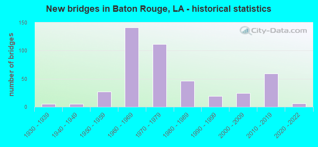
- New bridges - historical statistics
- 51930-1939
- 51940-1949
- 271950-1959
- 1411960-1969
- 1121970-1979
- 461980-1989
- 191990-1999
- 242000-2009
- 592010-2019
- 62020-2022

- Reconstructed bridges - Historical Statistics
- 51980-1989
- 01990-1999
- 132000-2009
- 12010-2019


- Bridge Condition - Deck
- 9.6%Very good
- 47.7%Good
- 37.6%Satisfactory
- 3.2%Fair
- 1.1%Poor
- 0.8%Serious

- Bridge Condition - Superstructure
- 15.2%Very good
- 40.3%Good
- 31.5%Satisfactory
- 9.1%Fair
- 2.1%Poor
- 1.9%Serious

- Bridge Condition - Substructure
- 14.4%Very good
- 46.9%Good
- 20.3%Satisfactory
- 4.8%Fair
- 8.0%Poor
- 5.3%Serious
- 0.3%Critical

- Bridge Condition - Channel
- 31.1%Very good
- 23.6%Good
- 29.1%Satisfactory
- 8.7%Fair
- 5.2%Poor
- 2.3%Serious

- Bridge Condition - Culverts
- 7.9%Very good
- 38.1%Good
- 44.4%Satisfactory
- 6.3%Fair
- 3.2%Poor
Find on map >> Show street view
Structure Number: 23602830801076, Location: 1.07 MI SOUTH OF I-10 (Lat: 29.946219, Lng: -90.080200), Route carried "on" structure: Ramp US 90, Year Built: 1960, Status: Open, Structure Length: 12.98m (42.59ft), Average Daily Traffic: 17,520 (year 2016), Truck Traffic: 25%, Average Future Daily Traffic: 28,866 (year 2036), Design Load: HS 20, Features Intersected: RAMP
Minimum Vertical Clearance: 30+ m (98+ ft), Kilometerpoint: 0.095, Lanes on structure: 1, Owner: State Highway Agency, Approaching Roadway Width: 6.1m (20.0ft), Material/Design: Steel, Design/Construction: Stringer/Multi-beam, Number Of Spans In Main Unit: 4, Number Of Approach Spans: 6, Length of Maximum Span: 17.4m (57.1ft), Curb-To-Curb Width: 6.1m (20.0ft), Out-to-Out Width: 7.5m (24.6ft)
Condition: Deck: Good, Superstructure: Good, Substructure: Good, Operating Rating: 75.3 metric tons, Method Used To Determine Operating Rating: Load Factor (LF), Inventory Rating: 45.4 metric tons, Method Used To Determine Inventory Rating: Load Factor (LF), Structural Evaluation: Better than present minimum criteria, Deck Geometry: Somewhat better than minimum adequacy, Approach Roadway Alignment: Better than present minimum criteria, Designated Inspection Frequency: Every 24 months, Inspection Date: March 2020, Deck Structure Type: Concrete Cast-file-Place
Find on map >> Show street view
Structure Number: 23604504305341, Location: I-510 OVER I-10 (Lat: 30.059050, Lng: -89.939161), Route carried "on" structure: Interstate 510, Year Built: 1967, Status: Open, Structure Length: 21.24m (69.69ft), Average Daily Traffic: 14,600 (year 2016), Truck Traffic: 25%, Average Future Daily Traffic: 29,070 (year 2036), Design Load: HS 20, Features Intersected: I-510(PARIS RD) OVER I-1
Minimum Vertical Clearance: 5.08m (16.67ft), Kilometerpoint: 4.960, Lanes on structure: 2, Lanes under structure: 6, Base Highway Network: Yes (Inventory Route: 450-43-1, Subroute: 10), Owner: State Highway Agency, Approaching Roadway Width: 15.2m (49.9ft), Skew: 10 degrees, Material/Design: Steel continuous, Design/Construction: Stringer/Multi-beam, Number Of Spans In Main Unit: 2, Number Of Approach Spans: 8, Length of Maximum Span: 28.3m (92.8ft), Curb-To-Curb Width: 10.8m (35.4ft), Out-to-Out Width: 27.1m (88.9ft)
Condition: Deck: Good, Superstructure: Good, Substructure: Good, Operating Rating: 73.5 metric tons, Method Used To Determine Operating Rating: Load Factor (LF), Inventory Rating: 43.5 metric tons, Method Used To Determine Inventory Rating: Load Factor (LF), Structural Evaluation: Better than present minimum criteria, Deck Geometry: Meets minimum limits, Underclear: Somewhat better than minimum adequacy, Approach Roadway Alignment: Equal to present desirable criteria, Designated Inspection Frequency: Every 24 months, Inspection Date: November 2020, Deck Structure Type: Concrete Cast-file-Place
Find on map >> Show street view
Structure Number: 23604504305342, Location: I-510 OVER I-10 (Lat: 30.060950, Lng: -89.939561), Route carried "on" structure: Interstate 510, Year Built: 1967, Status: Open, Structure Length: 21.73m (71.29ft), Average Daily Traffic: 14,600 (year 2016), Truck Traffic: 25%, Average Future Daily Traffic: 29,070 (year 2036), Design Load: HS 20, Features Intersected: I-510(PARIS RD) OVER I-1
Minimum Vertical Clearance: 5.03m (16.50ft), Kilometerpoint: 0.352, Lanes on structure: 2, Lanes under structure: 6, Base Highway Network: Yes (Inventory Route: 450-43-2, Subroute: 10), Owner: State Highway Agency, Approaching Roadway Width: 15.2m (49.9ft), Skew: 10 degrees, Material/Design: Steel continuous, Design/Construction: Stringer/Multi-beam, Number Of Spans In Main Unit: 2, Number Of Approach Spans: 9, Length of Maximum Span: 28.3m (92.8ft), Curb-To-Curb Width: 10.8m (35.4ft), Out-to-Out Width: 27.1m (88.9ft)
Condition: Deck: Good, Superstructure: Good, Substructure: Good, Operating Rating: 65.3 metric tons, Method Used To Determine Operating Rating: Load Factor (LF), Inventory Rating: 41.7 metric tons, Method Used To Determine Inventory Rating: Load Factor (LF), Structural Evaluation: Better than present minimum criteria, Deck Geometry: Meets minimum limits, Underclear: Somewhat better than minimum adequacy, Approach Roadway Alignment: Equal to present desirable criteria, Designated Inspection Frequency: Every 24 months, Inspection Date: November 2020, Deck Structure Type: Concrete Cast-file-Place
Find on map >> Show street view
Structure Number: 23808380100001, Location: 3.9 MI WEST OF LA 23 (Lat: 29.838550, Lng: -90.053311), Route carried "on" structure: State highway 3017, Year Built: 1971, Status: Open, Structure Length: 8.53m (27.99ft), Average Daily Traffic: 7,700 (year 2016), Truck Traffic: 11%, Average Future Daily Traffic: 13,090 (year 2036), Design Load: HS 20, Features Intersected: BAYOU BARATARIA
Minimum Vertical Clearance: 30+ m (98+ ft), Kilometerpoint: 0.000, Lanes on structure: 2, Owner: State Highway Agency, Approaching Roadway Width: 14.6m (47.9ft), Skew: 2 degrees, Material/Design: Concrete, Design/Construction: Slab, Number Of Spans In Main Unit: 13, Length of Maximum Span: 6.1m (20.0ft), Curb-To-Curb Width: 9.1m (29.9ft), Out-to-Out Width: 10.5m (34.4ft)
Condition: Deck: Satisfactory, Superstructure: Satisfactory, Substructure: Fair, Channel: Good, Operating Rating: 27.9 metric tons, Method Used To Determine Operating Rating: Load and Resistance Factor Rating (LRFR) rating reported by rating factor(RF) method using HL-93 loadings, Inventory Rating: 21.4 metric tons, Method Used To Determine Inventory Rating: Load and Resistance Factor Rating (LRFR) rating reported by rating factor(RF) method using HL-93 loadings, Structural Evaluation: Somewhat better than minimum adequacy, Deck Geometry: Meets minimum limits, Waterway Adequacy: Equal to present desirable criteria, Approach Roadway Alignment: Equal to present desirable criteria, Designated Inspection Frequency: Every 24 months, Underwater Inspection Frequency: Every 60 months, Inspection Date: August 2021, Underwater Inspection Date: March 2019, Deck Structure Type: Concrete Cast-file-Place
Find on map >> Show street view
Structure Number: 23808380303111, Location: 3.11 MI NORTH OF LA 23 (Lat: 29.865181, Lng: -89.995700), Route carried "on" structure: State highway 406, Year Built: 1977, Status: Open, Structure Length: 1.83m (6.00ft), Average Daily Traffic: 10,700 (year 2016), Truck Traffic: 11%, Average Future Daily Traffic: 18,020 (year 2036), Design Load: HS 20, Features Intersected: INDUSTRY CANAL
Minimum Vertical Clearance: 30+ m (98+ ft), Kilometerpoint: 0.323, Lanes on structure: 2, Owner: State Highway Agency, Approaching Roadway Width: 12.2m (40.0ft), Skew: 6 degrees, Material/Design: Concrete, Design/Construction: Slab, Number Of Spans In Main Unit: 3, Length of Maximum Span: 6.1m (20.0ft), Curb-To-Curb Width: 12.2m (40.0ft), Out-to-Out Width: 12.9m (42.3ft)
Condition: Deck: Good, Superstructure: Good, Substructure: Good, Channel: Satisfactory, Operating Rating: 61.7 metric tons, Method Used To Determine Operating Rating: Load Factor (LF), Inventory Rating: 37.2 metric tons, Method Used To Determine Inventory Rating: Load Factor (LF), Structural Evaluation: Better than present minimum criteria, Deck Geometry: Somewhat better than minimum adequacy, Waterway Adequacy: Better than present minimum criteria, Approach Roadway Alignment: Equal to present desirable criteria, Designated Inspection Frequency: Every 24 months, Inspection Date: September 2021, Deck Structure Type: Concrete Cast-file-Place
Find on map >> Show street view
Structure Number: 610300000000124, Location: 0.9 M E of LA 73 (Lat: 30.269189, Lng: -90.968600), Route carried "on" structure: State highway 621, Year Built: 2019, Status: Open, Structure Length: 1.83m (6.00ft), Average Daily Traffic: 5,700 (year 2016), Average Future Daily Traffic: 6,050 (year 2036), Design Load: Greater than HL93, Features Intersected: Goudine Bayou
Minimum Vertical Clearance: 30+ m (98+ ft), Kilometerpoint: 1.539, Lanes on structure: 2, Owner: State Highway Agency, Approaching Roadway Width: 8.5m (27.9ft), Material/Design: Concrete, Design/Construction: Slab, Number Of Spans In Main Unit: 3, Length of Maximum Span: 6.1m (20.0ft), Curb-To-Curb Width: 9.8m (32.2ft), Out-to-Out Width: 10.5m (34.4ft)
Condition: Deck: Very good, Superstructure: Very good, Substructure: Very good, Channel: Very good, Operating Rating: 71.3 metric tons, Method Used To Determine Operating Rating: Load and Resistance Factor Rating (LRFR) rating reported by rating factor(RF) method using HL-93 loadings, Inventory Rating: 55.1 metric tons, Method Used To Determine Inventory Rating: Load and Resistance Factor Rating (LRFR) rating reported by rating factor(RF) method using HL-93 loadings, Structural Evaluation: Equal to present desirable criteria, Deck Geometry: Meets minimum limits, Waterway Adequacy: Equal to present desirable criteria, Approach Roadway Alignment: Equal to present desirable criteria, Designated Inspection Frequency: Every 24 months, Inspection Date: June 2021, Deck Structure Type: Concrete Cast-file-Place
Find on map >> Show street view
Structure Number: 610302600108071, Location: 0.09 M SE of LA 42&LA 431 (Lat: 30.332531, Lng: -90.854411), Route carried "on" structure: State highway 42, Year Built: 1984, Status: Open, Structure Length: 3.47m (11.38ft), Average Daily Traffic: 9,200 (year 2016), Truck Traffic: 7%, Average Future Daily Traffic: 15,470 (year 2036), Design Load: HS 20, Features Intersected: BAYOU VILLAR
Minimum Vertical Clearance: 30+ m (98+ ft), Kilometerpoint: 13.153, Lanes on structure: 2, Owner: State Highway Agency, Approaching Roadway Width: 12.2m (40.0ft), Material/Design: Concrete, Design/Construction: Slab, Number Of Spans In Main Unit: 6, Length of Maximum Span: 5.8m (19.0ft), Curb-To-Curb Width: 11.0m (36.1ft), Out-to-Out Width: 12.2m (40.0ft)
Condition: Deck: Satisfactory, Superstructure: Satisfactory, Substructure: Satisfactory, Channel: Very good, Operating Rating: 39.9 metric tons, Method Used To Determine Operating Rating: Load and Resistance Factor Rating (LRFR) rating reported by rating factor(RF) method using HL-93 loadings, Inventory Rating: 30.8 metric tons, Method Used To Determine Inventory Rating: Load and Resistance Factor Rating (LRFR) rating reported by rating factor(RF) method using HL-93 loadings, Structural Evaluation: Equal to present minimum criteria, Deck Geometry: Meets minimum limits, Waterway Adequacy: Equal to present desirable criteria, Approach Roadway Alignment: Equal to present desirable criteria, Designated Inspection Frequency: Every 24 months, Inspection Date: July 2020, Deck Structure Type: Concrete Cast-file-Place, Wearing Surface/Protective System: Wearing Surface: Bituminous
Find on map >> Show street view
Structure Number: 610308030106391, Location: 1.4 M W of LA 1&LA 943 (Lat: 30.108069, Lng: -91.065119), Route carried "on" structure: State highway 943, Year Built: 1972, Status: Posted for load, Structure Length: 1.74m (5.71ft), Average Daily Traffic: 420 (year 2016), Truck Traffic: 10%, Average Future Daily Traffic: 663 (year 2036), Design Load: HS 20, Features Intersected: BAYOU MCCALL
Minimum Vertical Clearance: 30+ m (98+ ft), Kilometerpoint: 10.202, Lanes on structure: 2, Owner: State Highway Agency, Approaching Roadway Width: 12.2m (40.0ft), Material/Design: Concrete, Design/Construction: Slab, Number Of Spans In Main Unit: 3, Length of Maximum Span: 5.8m (19.0ft), Curb-To-Curb Width: 8.5m (27.9ft), Out-to-Out Width: 9.4m (30.8ft)
Condition: Deck: Good, Superstructure: Good, Substructure: Poor, Channel: Satisfactory, Operating Rating: 22.4 metric tons, Method Used To Determine Operating Rating: Load and Resistance Factor Rating (LRFR) rating reported by rating factor(RF) method using HL-93 loadings, Inventory Rating: 17.2 metric tons, Method Used To Determine Inventory Rating: Load and Resistance Factor Rating (LRFR) rating reported by rating factor(RF) method using HL-93 loadings, Structural Evaluation: Meets minimum limits, Deck Geometry: Somewhat better than minimum adequacy, Waterway Adequacy: Equal to present desirable criteria, Approach Roadway Alignment: Equal to present desirable criteria, Bridge Posting: Required (Relationship of Operating Rating to Maximum Legal Load: 20.0 - 29.9% below), Length Of Structure Improvement: 2.44m (8.01ft), Designated Inspection Frequency: Every 24 months, Other Special Inspection Frequency: Every 12 months, Inspection Date: January 2020, Other Special Inspection Date: January 2021, Bridge Improvement Cost: $208,000, Total Project Cost: $312,000 ( Estimate for 2016), Deck Structure Type: Concrete Cast-file-Place, Wearing Surface/Protective System: Wearing Surface: Monolithic Concrete
Find on map >> Show street view
Structure Number: 611700000000025, Location: 1.6 M W OF LA 37 (Lat: 30.587561, Lng: -91.024939), Route carried "on" structure: County highway , Year Built: 2019, Status: Open, Structure Length: 3.05m (10.01ft), Average Daily Traffic: 4,616 (year 2019), Average Future Daily Traffic: 5,078 (year 2039), Design Load: Greater than HL93, Features Intersected: BEAVER BAYOU, Facility Carried by Structure: DENHAM RD
Minimum Vertical Clearance: 30+ m (98+ ft), Kilometerpoint: 0.000, Lanes on structure: 2, Owner: County Highway Agency, Maintenance Responsibility: City or Municipal Highway Agency, Approaching Roadway Width: 6.7m (22.0ft), Material/Design: Concrete, Design/Construction: Slab, Number Of Spans In Main Unit: 5, Length of Maximum Span: 6.1m (20.0ft), Curb-To-Curb Width: 9.6m (31.5ft), Out-to-Out Width: 10.5m (34.4ft)
Condition: Deck: Very good, Superstructure: Very good, Substructure: Very good, Channel: Good, Operating Rating: 59.9 metric tons, Method Used To Determine Operating Rating: Load and Resistance Factor Rating (LRFR) rating reported by rating factor(RF) method using HL-93 loadings, Inventory Rating: 46.3 metric tons, Method Used To Determine Inventory Rating: Load and Resistance Factor Rating (LRFR) rating reported by rating factor(RF) method using HL-93 loadings, Structural Evaluation: Equal to present desirable criteria, Deck Geometry: Meets minimum limits, Waterway Adequacy: Equal to present desirable criteria, Approach Roadway Alignment: Equal to present desirable criteria, Designated Inspection Frequency: Every 24 months, Inspection Date: September 2021, Deck Structure Type: Concrete Cast-file-Place
Find on map >> Show street view
Structure Number: 611700000000027, Location: 0.77 M E OF LA 1248 (Lat: 30.387600, Lng: -91.075519), Route carried "on" structure: City street , Year Built: 2019, Status: Open, Structure Length: 0.88m (2.89ft), Average Daily Traffic: 7,000 (year 2014), Truck Traffic: 4%, Average Future Daily Traffic: 7,700 (year 2034), Design Load: Greater than HL93, Features Intersected: DRAINAGE DITCH, Facility Carried by Structure: THE GROVE BLVD
Minimum Vertical Clearance: 30+ m (98+ ft), Kilometerpoint: 0.000, Lanes on structure: 2, Owner: County Highway Agency, Approaching Roadway Width: 6.0m (19.7ft), Material/Design: Concrete, Design/Construction: Culvert, Number Of Spans In Main Unit: 3, Length of Maximum Span: 2.7m (8.9ft), Curb-To-Curb Width: 6.0m (19.7ft), Out-to-Out Width: 6.4m (21.0ft)
Condition: Channel: Very good, Culverts: Good, Operating Rating: 59.3 metric tons, Method Used To Determine Operating Rating: Load and Resistance Factor Rating (LRFR) rating reported by rating factor(RF) method using HL-93 loadings, Inventory Rating: 45.7 metric tons, Method Used To Determine Inventory Rating: Load and Resistance Factor Rating (LRFR) rating reported by rating factor(RF) method using HL-93 loadings, Structural Evaluation: Better than present minimum criteria, Deck Geometry: High priority of replacement, Waterway Adequacy: Equal to present desirable criteria, Approach Roadway Alignment: Equal to present desirable criteria, Designated Inspection Frequency: Every 24 months, Inspection Date: May 2021
Find on map >> Show street view
Structure Number: 611700000000028, Location: 0.2 Mi. W. of I-10 (Lat: 30.386519, Lng: -91.078050), Route carried "on" structure: City street , Year Built: 2019, Status: Open, Structure Length: 9.33m (30.61ft), Average Daily Traffic: 450 (year 2019), Average Future Daily Traffic: 500 (year 2039), Design Load: Greater than HL93, Features Intersected: WARD CREEK, Facility Carried by Structure: THE GROVE BLVD
Minimum Vertical Clearance: 30+ m (98+ ft), Kilometerpoint: 0.000, Lanes on structure: 2, Owner: County Highway Agency, Approaching Roadway Width: 10.3m (33.8ft), Material/Design: Concrete, Design/Construction: Stringer/Multi-beam, Number Of Spans In Main Unit: 8, Length of Maximum Span: 11.6m (38.1ft), Curb or Sidewalk Widths: Left: 0.0m, Right: 3.3m (10.8ft), Curb-To-Curb Width: 8.5m (27.9ft), Out-to-Out Width: 12.6m (41.3ft)
Condition: Deck: Very good, Superstructure: Very good, Substructure: Good, Channel: Very good, Operating Rating: 68.7 metric tons, Method Used To Determine Operating Rating: Load and Resistance Factor Rating (LRFR) rating reported by rating factor(RF) method using HL-93 loadings, Inventory Rating: 52.8 metric tons, Method Used To Determine Inventory Rating: Load and Resistance Factor Rating (LRFR) rating reported by rating factor(RF) method using HL-93 loadings, Structural Evaluation: Better than present minimum criteria, Deck Geometry: Somewhat better than minimum adequacy, Waterway Adequacy: Equal to present desirable criteria, Approach Roadway Alignment: Equal to present desirable criteria, Designated Inspection Frequency: Every 24 months, Inspection Date: May 2021, Deck Structure Type: Concrete Cast-file-Place
Find on map >> Show street view
Structure Number: 611700000000107, Location: 0.4 MI W OF O'NEAL LN (Lat: 30.435211, Lng: -91.015000), Route carried "on" structure: County highway , Year Built: 2018, Status: Open, Structure Length: 1.98m (6.50ft), Average Daily Traffic: 1,600 (year 2017), Average Future Daily Traffic: 1,800 (year 2039), Design Load: Greater than HL93, Features Intersected: KNOX BRANCH, Facility Carried by Structure: FIREWOOD DR
Minimum Vertical Clearance: 30+ m (98+ ft), Kilometerpoint: 0.000, Lanes on structure: 2, Owner: County Highway Agency, Approaching Roadway Width: 7.9m (25.9ft), Material/Design: Concrete, Design/Construction: Slab, Number Of Spans In Main Unit: 3, Length of Maximum Span: 7.6m (24.9ft), Curb or Sidewalk Widths: Left: 1.8m (5.9ft), Right: 1.8m (5.9ft), Curb-To-Curb Width: 8.5m (27.9ft), Out-to-Out Width: 12.5m (41.0ft)
Condition: Deck: Very good, Superstructure: Very good, Substructure: Very good, Channel: Very good, Operating Rating: 55.7 metric tons, Method Used To Determine Operating Rating: Load and Resistance Factor Rating (LRFR) rating reported by rating factor(RF) method using HL-93 loadings, Inventory Rating: 42.8 metric tons, Method Used To Determine Inventory Rating: Load and Resistance Factor Rating (LRFR) rating reported by rating factor(RF) method using HL-93 loadings, Structural Evaluation: Equal to present desirable criteria, Deck Geometry: Somewhat better than minimum adequacy, Waterway Adequacy: Equal to present desirable criteria, Approach Roadway Alignment: Equal to present desirable criteria, Designated Inspection Frequency: Every 24 months, Inspection Date: July 2021, Deck Structure Type: Concrete Cast-file-Place
Find on map >> Show street view
Structure Number: 611700000000153, Location: 0.6 MI N OF US 190 (Lat: 30.470589, Lng: -91.034631), Route carried "on" structure: County highway , Year Built: 2019, Status: Open, Structure Length: 2.44m (8.01ft), Average Daily Traffic: 14,900 (year 2017), Average Future Daily Traffic: 16,000 (year 2037), Design Load: Greater than HL93, Features Intersected: LIVELY BAYOU, Facility Carried by Structure: NORTH FLANNERY RD
Minimum Vertical Clearance: 30+ m (98+ ft), Kilometerpoint: 0.937, Lanes on structure: 2, Owner: County Highway Agency, Approaching Roadway Width: 9.4m (30.8ft), Skew: 3 degrees, Material/Design: Concrete, Design/Construction: Stringer/Multi-beam, Number Of Spans In Main Unit: 1, Number Of Approach Spans: 2, Length of Maximum Span: 12.2m (40.0ft), Curb-To-Curb Width: 8.5m (27.9ft), Out-to-Out Width: 9.3m (30.5ft)
Condition: Deck: Very good, Superstructure: Very good, Substructure: Good, Channel: Very good, Operating Rating: 71.3 metric tons, Method Used To Determine Operating Rating: Load and Resistance Factor Rating (LRFR) rating reported by rating factor(RF) method using HL-93 loadings, Inventory Rating: 42.1 metric tons, Method Used To Determine Inventory Rating: Load and Resistance Factor Rating (LRFR) rating reported by rating factor(RF) method using HL-93 loadings, Structural Evaluation: Better than present minimum criteria, Deck Geometry: High priority of replacement, Waterway Adequacy: Equal to present desirable criteria, Approach Roadway Alignment: Equal to present desirable criteria, Designated Inspection Frequency: Every 24 months, Inspection Date: May 2021, Deck Structure Type: Concrete Cast-file-Place
Find on map >> Show street view
Structure Number: 61170000000016, Location: 1.7 M S OF US 61 (Lat: 30.484719, Lng: -91.140511), Route carried "on" structure: County highway , Year Built: 1970, Status: Open, Structure Length: 0.91m (2.99ft), Average Daily Traffic: 6,851 (year 2014), Average Future Daily Traffic: 7,536 (year 2034), Design Load: HS 20, Features Intersected: HURRICANE CREEK, Facility Carried by Structure: NORTH FOSTER DR.
Minimum Vertical Clearance: 30+ m (98+ ft), Kilometerpoint: 4.017, Lanes on structure: 4, Owner: County Highway Agency, Approaching Roadway Width: 20.1m (65.9ft), Material/Design: Concrete, Design/Construction: Culvert, Number Of Spans In Main Unit: 3, Length of Maximum Span: 2.7m (8.9ft), Curb or Sidewalk Widths: Left: 2.4m (7.9ft), Right: 2.4m (7.9ft), Curb-To-Curb Width: 18.3m (60.0ft), Out-to-Out Width: 18.3m (60.0ft)
Condition: Channel: Good, Culverts: Good, Operating Rating: 42.1 metric tons, Method Used To Determine Operating Rating: Load and Resistance Factor Rating (LRFR) rating reported by rating factor(RF) method using HL-93 loadings, Inventory Rating: 32.4 metric tons, Method Used To Determine Inventory Rating: Load and Resistance Factor Rating (LRFR) rating reported by rating factor(RF) method using HL-93 loadings, Structural Evaluation: Better than present minimum criteria, Deck Geometry: Somewhat better than minimum adequacy, Waterway Adequacy: Better than present minimum criteria, Approach Roadway Alignment: Better than present minimum criteria, Designated Inspection Frequency: Every 24 months, Inspection Date: June 2021
Find on map >> Show street view
Structure Number: 611700000610007, Location: 0.2 M W OF US 61 (Lat: 30.390400, Lng: -91.050200), Route carried "on" structure: County highway , Year Built: 2019, Status: Open, Structure Length: 1.83m (6.00ft), Average Daily Traffic: 2,250 (year 2017), Average Future Daily Traffic: 2,700 (year 2027), Design Load: Greater than HL93, Features Intersected: DRAINAGE CANAL, Facility Carried by Structure: CLOVERLAND AVE.
Minimum Vertical Clearance: 30+ m (98+ ft), Kilometerpoint: 0.000, Lanes on structure: 2, Owner: County Highway Agency, Approaching Roadway Width: 8.7m (28.5ft), Material/Design: Concrete, Design/Construction: Slab, Number Of Spans In Main Unit: 3, Length of Maximum Span: 6.1m (20.0ft), Curb or Sidewalk Widths: Left: 1.8m (5.9ft), Right: 1.8m (5.9ft), Curb-To-Curb Width: 8.4m (27.6ft), Out-to-Out Width: 13.4m (44.0ft)
Condition: Deck: Good, Superstructure: Good, Substructure: Good, Channel: Very good, Operating Rating: 58.3 metric tons, Method Used To Determine Operating Rating: Load and Resistance Factor Rating (LRFR) rating reported by rating factor(RF) method using HL-93 loadings, Inventory Rating: 44.7 metric tons, Method Used To Determine Inventory Rating: Load and Resistance Factor Rating (LRFR) rating reported by rating factor(RF) method using HL-93 loadings, Structural Evaluation: Better than present minimum criteria, Deck Geometry: High priority of corrective action, Waterway Adequacy: Equal to present desirable criteria, Approach Roadway Alignment: Equal to present desirable criteria, Designated Inspection Frequency: Every 24 months, Inspection Date: July 2021, Deck Structure Type: Concrete Cast-file-Place
Find on map >> Show street view
Structure Number: 611700000610012, Location: 1.0 MI SW OF US 61 (Lat: 30.367019, Lng: -91.046811), Route carried "on" structure: County highway , Year Built: 2021, Status: Open, Structure Length: 6.52m (21.39ft), Average Daily Traffic: 41,300 (year 2019), Truck Traffic: 5%, Average Future Daily Traffic: 62,600 (year 2039), Design Load: Greater than HL93, Features Intersected: I-10, Facility Carried by Structure: PECUE LANE
Minimum Vertical Clearance: 30+ m (98+ ft), Kilometerpoint: 0.948, Lanes on structure: 2, Lanes under structure: 6, Owner: State Highway Agency, Approaching Roadway Width: 7.3m (24.0ft), Skew: 1 degrees, Material/Design: Concrete, Design/Construction: Stringer/Multi-beam, Number Of Spans In Main Unit: 2, Length of Maximum Span: 33.5m (109.9ft), Curb-To-Curb Width: 18.6m (61.0ft), Out-to-Out Width: 19.3m (63.3ft)
Condition: Deck: Very good, Superstructure: Very good, Substructure: Very good, Operating Rating: 58.3 metric tons, Method Used To Determine Operating Rating: Load and Resistance Factor Rating (LRFR) rating reported by rating factor(RF) method using HL-93 loadings, Inventory Rating: 45.0 metric tons, Method Used To Determine Inventory Rating: Load and Resistance Factor Rating (LRFR) rating reported by rating factor(RF) method using HL-93 loadings, Structural Evaluation: Equal to present desirable criteria, Deck Geometry: Superior to present desirable criteria, Underclear: High priority of corrective action, Approach Roadway Alignment: Equal to present desirable criteria, Designated Inspection Frequency: Every 24 months, Inspection Date: September 2021, Deck Structure Type: Concrete Cast-file-Place
Find on map >> Show street view
Structure Number: 611700000610083, Location: E. GRANT ST. (Lat: 30.423119, Lng: -91.178111), Route carried "on" structure: County highway , Year Built: 1992, Status: Open, Structure Length: 1.74m (5.71ft), Average Daily Traffic: 350 (year 2019), Average Future Daily Traffic: 385 (year 2039), Design Load: HS 20, Features Intersected: CORPORATION CANAL, Facility Carried by Structure: E Grant St
Minimum Vertical Clearance: 30+ m (98+ ft), Kilometerpoint: 0.000, Lanes on structure: 2, Base Highway Network: Yes, Owner: County Highway Agency, Approaching Roadway Width: 8.5m (27.9ft), Skew: 5 degrees, Material/Design: Concrete, Design/Construction: Slab, Number Of Spans In Main Unit: 3, Length of Maximum Span: 5.8m (19.0ft), Curb or Sidewalk Widths: Left: 1.5m (4.9ft), Right: 1.5m (4.9ft), Curb-To-Curb Width: 8.5m (27.9ft), Out-to-Out Width: 12.2m (40.0ft)
Condition: Deck: Good, Superstructure: Good, Substructure: Good, Channel: Very good, Operating Rating: 36.0 metric tons, Method Used To Determine Operating Rating: Load and Resistance Factor Rating (LRFR) rating reported by rating factor(RF) method using HL-93 loadings, Inventory Rating: 27.9 metric tons, Method Used To Determine Inventory Rating: Load and Resistance Factor Rating (LRFR) rating reported by rating factor(RF) method using HL-93 loadings, Structural Evaluation: Better than present minimum criteria, Deck Geometry: Equal to present minimum criteria, Waterway Adequacy: Equal to present desirable criteria, Approach Roadway Alignment: Equal to present desirable criteria, Designated Inspection Frequency: Every 24 months, Inspection Date: November 2021, Deck Structure Type: Concrete Cast-file-Place, Wearing Surface/Protective System: Wearing Surface: Monolithic Concrete
Find on map >> Show street view
Structure Number: 611700000610098, Location: 0.5 MILES SOUTH OF I 110 (Lat: 30.524281, Lng: -91.169189), Route carried "on" structure: County highway , Year Built: 2014, Status: Open, Structure Length: 3.05m (10.01ft), Average Daily Traffic: 2,362 (year 2019), Average Future Daily Traffic: 2,598 (year 2039), Design Load: HS 20, Features Intersected: MONTE SANO BAYOU, Facility Carried by Structure: Elm Grove Garden
Minimum Vertical Clearance: 30+ m (98+ ft), Kilometerpoint: 0.000, Lanes on structure: 2, Owner: County Highway Agency, Approaching Roadway Width: 9.1m (29.9ft), Skew: 30 degrees, Material/Design: Concrete, Design/Construction: Slab, Number Of Spans In Main Unit: 5, Length of Maximum Span: 6.1m (20.0ft), Curb or Sidewalk Widths: Left: 1.8m (5.9ft), Right: 0.0m, Curb-To-Curb Width: 9.1m (29.9ft), Out-to-Out Width: 11.6m (38.1ft)
Condition: Deck: Good, Superstructure: Good, Substructure: Very good, Channel: Very good, Operating Rating: 45.4 metric tons, Method Used To Determine Operating Rating: Load and Resistance Factor Rating (LRFR) rating reported by rating factor(RF) method using HL-93 loadings, Inventory Rating: 35.0 metric tons, Method Used To Determine Inventory Rating: Load and Resistance Factor Rating (LRFR) rating reported by rating factor(RF) method using HL-93 loadings, Structural Evaluation: Better than present minimum criteria, Deck Geometry: Meets minimum limits, Waterway Adequacy: Equal to present desirable criteria, Approach Roadway Alignment: Equal to present desirable criteria, Designated Inspection Frequency: Every 24 months, Inspection Date: Febuary 2020, Deck Structure Type: Concrete Cast-file-Place, Wearing Surface/Protective System: Wearing Surface: Wood or Timber
Find on map >> Show street view
Structure Number: 611700000610111, Location: LANIER DR. 0.2 OF A MILE (Lat: 30.505061, Lng: -91.107931), Route carried "on" structure: County highway , Year Built: 2012, Status: Open, Structure Length: 3.66m (12.01ft), Average Daily Traffic: 4,700 (year 2019), Truck Traffic: 1%, Average Future Daily Traffic: 5,170 (year 2039), Design Load: HS 20, Features Intersected: CANAL, Facility Carried by Structure: Lanier Dr
Minimum Vertical Clearance: 30+ m (98+ ft), Kilometerpoint: 0.000, Lanes on structure: 2, Owner: City or Municipal Highway Agency, Approaching Roadway Width: 8.5m (27.9ft), Skew: 34 degrees, Material/Design: Concrete, Design/Construction: Slab, Number Of Spans In Main Unit: 6, Length of Maximum Span: 6.1m (20.0ft), Curb or Sidewalk Widths: Left: 2.0m (6.6ft), Right: 2.0m (6.6ft), Curb-To-Curb Width: 9.1m (29.9ft), Out-to-Out Width: 13.1m (43.0ft)
Condition: Deck: Good, Superstructure: Good, Substructure: Good, Channel: Very good, Operating Rating: 46.7 metric tons, Method Used To Determine Operating Rating: Load and Resistance Factor Rating (LRFR) rating reported by rating factor(RF) method using HL-93 loadings, Inventory Rating: 36.0 metric tons, Method Used To Determine Inventory Rating: Load and Resistance Factor Rating (LRFR) rating reported by rating factor(RF) method using HL-93 loadings, Structural Evaluation: Better than present minimum criteria, Deck Geometry: Meets minimum limits, Waterway Adequacy: Equal to present desirable criteria, Approach Roadway Alignment: Equal to present desirable criteria, Designated Inspection Frequency: Every 24 months, Inspection Date: January 2022, Deck Structure Type: Concrete Cast-file-Place, Wearing Surface/Protective System: Wearing Surface: Monolithic Concrete
Find on map >> Show street view
Structure Number: 611700000610252, Location: LA 67 APPROX. .1 MI SOUTH (Lat: 30.542111, Lng: -91.136469), Route carried "on" structure: State highway 67, Year Built: 2009, Status: Open, Structure Length: 5.85m (19.19ft), Average Daily Traffic: 16,200 (year 2016), Truck Traffic: 9%, Average Future Daily Traffic: 27,604 (year 2036), Design Load: HS 20, Features Intersected: CYPRESS BAYOU
Minimum Vertical Clearance: 30+ m (98+ ft), Kilometerpoint: 1.846, Lanes on structure: 2, Base Highway Network: Yes (Inventory Route: 60-01-2, Subroute: 10), Owner: State Highway Agency, Approaching Roadway Width: 12.2m (40.0ft), Skew: 31 degrees, Material/Design: Prestressed concrete continuous, Design/Construction: Stringer/Multi-beam, Number Of Spans In Main Unit: 4, Length of Maximum Span: 14.6m (47.9ft), Curb-To-Curb Width: 12.2m (40.0ft), Out-to-Out Width: 12.9m (42.3ft)
Condition: Deck: Very good, Superstructure: Very good, Substructure: Very good, Channel: Very good, Operating Rating: 59.3 metric tons, Method Used To Determine Operating Rating: Load and Resistance Factor Rating (LRFR) rating reported by rating factor(RF) method using HL-93 loadings, Inventory Rating: 41.8 metric tons, Method Used To Determine Inventory Rating: Load and Resistance Factor Rating (LRFR) rating reported by rating factor(RF) method using HL-93 loadings, Structural Evaluation: Equal to present desirable criteria, Deck Geometry: Better than present minimum criteria, Waterway Adequacy: Equal to present desirable criteria, Approach Roadway Alignment: Equal to present desirable criteria, Designated Inspection Frequency: Every 24 months, Inspection Date: July 2020, Deck Structure Type: Concrete Cast-file-Place, Wearing Surface/Protective System: Wearing Surface: Monolithic Concrete
Find on map >> Show street view
Structure Number: 611700000610253, Location: APPROX. .1 MI. SOUTH OF B (Lat: 30.542081, Lng: -91.136239), Route carried "on" structure: State highway 67, Year Built: 2009, Status: Open, Structure Length: 5.85m (19.19ft), Average Daily Traffic: 16,200 (year 2016), Truck Traffic: 9%, Average Future Daily Traffic: 27,604 (year 2036), Design Load: HS 20, Features Intersected: CYPRESS BAYOU
Minimum Vertical Clearance: 30+ m (98+ ft), Kilometerpoint: 11.372, Lanes on structure: 2, Base Highway Network: Yes (Inventory Route: 60-01-1, Subroute: 10), Owner: State Highway Agency, Approaching Roadway Width: 12.2m (40.0ft), Skew: 31 degrees, Material/Design: Prestressed concrete continuous, Design/Construction: Stringer/Multi-beam, Number Of Spans In Main Unit: 4, Length of Maximum Span: 14.6m (47.9ft), Curb-To-Curb Width: 12.2m (40.0ft), Out-to-Out Width: 12.9m (42.3ft)
Condition: Deck: Good, Superstructure: Very good, Substructure: Good, Channel: Very good, Operating Rating: 64.8 metric tons, Method Used To Determine Operating Rating: Load and Resistance Factor Rating (LRFR) rating reported by rating factor(RF) method using HL-93 loadings, Inventory Rating: 47.6 metric tons, Method Used To Determine Inventory Rating: Load and Resistance Factor Rating (LRFR) rating reported by rating factor(RF) method using HL-93 loadings, Structural Evaluation: Better than present minimum criteria, Deck Geometry: Better than present minimum criteria, Waterway Adequacy: Equal to present desirable criteria, Approach Roadway Alignment: Equal to present desirable criteria, Designated Inspection Frequency: Every 24 months, Inspection Date: July 2020, Deck Structure Type: Concrete Cast-file-Place, Wearing Surface/Protective System: Wearing Surface: Monolithic Concrete
Find on map >> Show street view
Structure Number: 611700000610256, Location: LA 946 APPROX. 2.4 MILES (Lat: 30.513119, Lng: -91.074861), Route carried "on" structure: State highway 946, Year Built: 2009, Status: Open, Structure Length: 13.72m (45.01ft), Average Daily Traffic: 12,700 (year 2016), Truck Traffic: 7%, Average Future Daily Traffic: 10,820 (year 2036), Design Load: HS 20, Features Intersected: COMITE RIVER
Minimum Vertical Clearance: 30+ m (98+ ft), Kilometerpoint: 3.859, Lanes on structure: 5, Owner: State Highway Agency, Approaching Roadway Width: 25.0m (82.0ft), Skew: 30 degrees, Material/Design: Prestressed concrete continuous, Design/Construction: Stringer/Multi-beam, Number Of Spans In Main Unit: 6, Length of Maximum Span: 22.9m (75.1ft), Curb-To-Curb Width: 25.0m (82.0ft), Out-to-Out Width: 25.7m (84.3ft)
Condition: Deck: Good, Superstructure: Very good, Substructure: Good, Channel: Very good, Operating Rating: 59.0 metric tons, Method Used To Determine Operating Rating: Load and Resistance Factor Rating (LRFR) rating reported by rating factor(RF) method using HL-93 loadings, Inventory Rating: 35.0 metric tons, Method Used To Determine Inventory Rating: Load and Resistance Factor Rating (LRFR) rating reported by rating factor(RF) method using HL-93 loadings, Structural Evaluation: Better than present minimum criteria, Deck Geometry: Superior to present desirable criteria, Waterway Adequacy: Equal to present desirable criteria, Approach Roadway Alignment: Equal to present desirable criteria, Designated Inspection Frequency: Every 24 months, Inspection Date: July 2020, Deck Structure Type: Concrete Cast-file-Place, Wearing Surface/Protective System: Wearing Surface: Monolithic Concrete
Find on map >> Show street view
Structure Number: 611700000610257, Location: LA 946 APPROX 2.2 MILES N (Lat: 30.512211, Lng: -91.077819), Route carried "on" structure: State highway 946, Year Built: 2009, Status: Open, Structure Length: 6.86m (22.51ft), Average Daily Traffic: 12,700 (year 2016), Truck Traffic: 7%, Average Future Daily Traffic: 10,820 (year 2036), Design Load: HS 20, Features Intersected: COMITE RIVER RELIEF
Minimum Vertical Clearance: 30+ m (98+ ft), Kilometerpoint: 3.552, Lanes on structure: 5, Owner: State Highway Agency, Approaching Roadway Width: 25.0m (82.0ft), Skew: 30 degrees, Material/Design: Prestressed concrete continuous, Design/Construction: Stringer/Multi-beam, Number Of Spans In Main Unit: 3, Length of Maximum Span: 22.9m (75.1ft), Curb-To-Curb Width: 25.0m (82.0ft), Out-to-Out Width: 25.6m (84.0ft)
Condition: Deck: Good, Superstructure: Very good, Substructure: Very good, Channel: Very good, Operating Rating: 60.9 metric tons, Method Used To Determine Operating Rating: Load and Resistance Factor Rating (LRFR) rating reported by rating factor(RF) method using HL-93 loadings, Inventory Rating: 35.0 metric tons, Method Used To Determine Inventory Rating: Load and Resistance Factor Rating (LRFR) rating reported by rating factor(RF) method using HL-93 loadings, Structural Evaluation: Equal to present desirable criteria, Deck Geometry: Superior to present desirable criteria, Waterway Adequacy: Equal to present desirable criteria, Approach Roadway Alignment: Equal to present desirable criteria, Designated Inspection Frequency: Every 24 months, Inspection Date: July 2020, Deck Structure Type: Concrete Cast-file-Place
Find on map >> Show street view
Structure Number: 611700000610259, Location: ON BLOUNT RD BETWEEN LA 6 (Lat: 30.544619, Lng: -91.142050), Route carried "on" structure: County highway , Year Built: 2010, Status: Open, Structure Length: 9.24m (30.31ft), Design Load: HS 20, Features Intersected: CREEK, Facility Carried by Structure: Blount Rd
Minimum Vertical Clearance: 30+ m (98+ ft), Kilometerpoint: 0.000, Lanes on structure: 2, Owner: City or Municipal Highway Agency, Approaching Roadway Width: 12.8m (42.0ft), Skew: 34 degrees, Material/Design: Prestressed concrete continuous, Design/Construction: Stringer/Multi-beam, Number Of Spans In Main Unit: 6, Length of Maximum Span: 15.2m (49.9ft), Curb-To-Curb Width: 12.2m (40.0ft), Out-to-Out Width: 12.8m (42.0ft)
Condition: Deck: Good, Superstructure: Very good, Substructure: Good, Channel: Very good, Operating Rating: 50.9 metric tons, Method Used To Determine Operating Rating: Load and Resistance Factor Rating (LRFR) rating reported by rating factor(RF) method using HL-93 loadings, Inventory Rating: 39.2 metric tons, Method Used To Determine Inventory Rating: Load and Resistance Factor Rating (LRFR) rating reported by rating factor(RF) method using HL-93 loadings, Structural Evaluation: Better than present minimum criteria, Deck Geometry: Superior to present desirable criteria, Waterway Adequacy: Better than present minimum criteria, Approach Roadway Alignment: Better than present minimum criteria, Designated Inspection Frequency: Every 24 months, Inspection Date: April 2020, Deck Structure Type: Concrete Cast-file-Place
Find on map >> Show street view
Structure Number: 611700000610262, Location: LA 427 APPROX. 1.04 MILES (Lat: 30.385681, Lng: -91.103119), Route carried "on" structure: County highway , Year Built: 2010, Status: Open, Structure Length: 4.88m (16.01ft), Average Daily Traffic: 25,100 (year 2016), Truck Traffic: 5%, Average Future Daily Traffic: 39,334 (year 2036), Design Load: HS 20, Features Intersected: DAWSON CREEK BRIDGE, Facility Carried by Structure: Perkins Rd
Minimum Vertical Clearance: 30+ m (98+ ft), Kilometerpoint: 11.827, Lanes on structure: 4, Owner: Town or Township Highway Agency, Maintenance Responsibility: County Highway Agency, Approaching Roadway Width: 22.6m (74.1ft), Skew: 36 degrees, Material/Design: Concrete, Design/Construction: Slab, Number Of Spans In Main Unit: 8, Length of Maximum Span: 6.1m (20.0ft), Curb or Sidewalk Widths: Left: 1.8m (5.9ft), Right: 1.8m (5.9ft), Curb-To-Curb Width: 22.6m (74.1ft), Out-to-Out Width: 26.8m (87.9ft)
Condition: Deck: Good, Superstructure: Good, Substructure: Good, Channel: Very good, Operating Rating: 33.4 metric tons, Method Used To Determine Operating Rating: Load and Resistance Factor Rating (LRFR) rating reported by rating factor(RF) method using HL-93 loadings, Inventory Rating: 25.6 metric tons, Method Used To Determine Inventory Rating: Load and Resistance Factor Rating (LRFR) rating reported by rating factor(RF) method using HL-93 loadings, Structural Evaluation: Equal to present minimum criteria, Deck Geometry: Superior to present desirable criteria, Waterway Adequacy: Equal to present desirable criteria, Approach Roadway Alignment: Equal to present desirable criteria, Designated Inspection Frequency: Every 24 months, Inspection Date: May 2021, Deck Structure Type: Concrete Cast-file-Place
Find on map >> Show street view
Structure Number: 611700000610264, Location: 1 MILE NORTH OF INTERSTAT (Lat: 30.450600, Lng: -91.026600), Route carried "on" structure: State highway 426, Year Built: 2006, Status: Open, Structure Length: 1.10m (3.61ft), Average Daily Traffic: 7,800 (year 2016), Truck Traffic: 9%, Average Future Daily Traffic: 11,218 (year 2036), Design Load: HS 20, Features Intersected: LIVELY BAYOU
Minimum Vertical Clearance: 30+ m (98+ ft), Kilometerpoint: 8.436, Lanes on structure: 4, Base Highway Network: Yes (Inventory Route: 817-09-1, Subroute: 10), Owner: State Highway Agency, Approaching Roadway Width: 19.5m (64.0ft), Skew: 30 degrees, Material/Design: Concrete, Design/Construction: Culvert, Number Of Spans In Main Unit: 5, Length of Maximum Span: 1.8m (5.9ft), Curb-To-Curb Width: 19.5m (64.0ft), Out-to-Out Width: 40.8m (133.9ft)
Condition: Channel: Good, Culverts: Satisfactory, Operating Rating: 42.1 metric tons, Method Used To Determine Operating Rating: Load and Resistance Factor Rating (LRFR) rating reported by rating factor(RF) method using HL-93 loadings, Inventory Rating: 32.4 metric tons, Method Used To Determine Inventory Rating: Load and Resistance Factor Rating (LRFR) rating reported by rating factor(RF) method using HL-93 loadings, Structural Evaluation: Equal to present minimum criteria, Deck Geometry: Better than present minimum criteria, Waterway Adequacy: Equal to present desirable criteria, Approach Roadway Alignment: Equal to present desirable criteria, Designated Inspection Frequency: Every 24 months, Inspection Date: May 2021, Deck Structure Type: Other
Find on map >> Show street view
Structure Number: 611700000610293, Location: 3.7 MILES SOUTHWEST OF JU (Lat: 30.386739, Lng: -91.160319), Route carried "on" structure: County highway , Year Built: 2000, Status: Open, Structure Length: 0.61m (2.00ft), Design Load: HS 20, Features Intersected: BAYOU, Facility Carried by Structure: Ben Hur Rd
Minimum Vertical Clearance: 30+ m (98+ ft), Kilometerpoint: 0.000, Lanes on structure: 2, Owner: County Highway Agency, Approaching Roadway Width: 7.3m (24.0ft), Skew: 30 degrees, Material/Design: Concrete, Design/Construction: Culvert, Number Of Spans In Main Unit: 2, Length of Maximum Span: 2.7m (8.9ft)
Condition: Channel: Good, Culverts: Satisfactory, Operating Rating: 42.1 metric tons, Method Used To Determine Operating Rating: Load and Resistance Factor Rating (LRFR) rating reported by rating factor(RF) method using HL-93 loadings, Inventory Rating: 32.4 metric tons, Method Used To Determine Inventory Rating: Load and Resistance Factor Rating (LRFR) rating reported by rating factor(RF) method using HL-93 loadings, Structural Evaluation: Equal to present minimum criteria, Waterway Adequacy: Equal to present desirable criteria, Approach Roadway Alignment: Equal to present desirable criteria, Designated Inspection Frequency: Every 24 months, Inspection Date: June 2021, Deck Structure Type: Concrete Cast-file-Place
Find on map >> Show street view
Structure Number: 611700000610295, Location: 0.7 M S of I-110&LA 73 (Lat: 30.433139, Lng: -91.176069), Route carried "on" structure: Interstate 10, Year Built: 1963, Status: Open, Structure Length: 76.93m (252.40ft), Average Daily Traffic: 74,950 (year 2016), Truck Traffic: 9%, Average Future Daily Traffic: 212,858 (year 2036), Design Load: HS 20, Features Intersected: WASHINGTON STREET
Minimum Vertical Clearance: 30+ m (98+ ft), Kilometerpoint: 1.315, Lanes on structure: 3, Lanes under structure: 3, Base Highway Network: Yes (Inventory Route: 450-10-1, Subroute: 10), Owner: State Highway Agency, Approaching Roadway Width: 12.2m (40.0ft), Skew: 30 degrees, Material/Design: Steel, Design/Construction: Stringer/Multi-beam, Number Of Spans In Main Unit: 50, Length of Maximum Span: 29.0m (95.1ft), Curb-To-Curb Width: 12.3m (40.4ft), Out-to-Out Width: 14.0m (45.9ft)
Condition: Deck: Good, Superstructure: Good, Substructure: Satisfactory, Operating Rating: 35.6 metric tons, Method Used To Determine Operating Rating: Load and Resistance Factor Rating (LRFR) rating reported by rating factor(RF) method using HL-93 loadings, Inventory Rating: 27.5 metric tons, Method Used To Determine Inventory Rating: Load and Resistance Factor Rating (LRFR) rating reported by rating factor(RF) method using HL-93 loadings, Structural Evaluation: Equal to present minimum criteria, Deck Geometry: Meets minimum limits, Underclear: Meets minimum limits, Approach Roadway Alignment: Equal to present desirable criteria, Designated Inspection Frequency: Every 24 months, Inspection Date: March 2020, Deck Structure Type: Other
Find on map >> Show street view
Structure Number: 611700000610297, Location: .08 MILES WEST OF S. HARR (Lat: 30.414169, Lng: -91.014739), Route carried "on" structure: County highway , Year Built: 2011, Status: Open, Structure Length: 6.10m (20.01ft), Average Daily Traffic: 19,939 (year 2019), Average Future Daily Traffic: 21,933 (year 2039), Design Load: HS 20, Features Intersected: CREEK, Facility Carried by Structure: Jones Creek Rd
Minimum Vertical Clearance: 30+ m (98+ ft), Kilometerpoint: 0.000, Lanes on structure: 2, Owner: County Highway Agency, Approaching Roadway Width: 7.3m (24.0ft), Skew: 30 degrees, Material/Design: Prestressed concrete, Design/Construction: Box Beam or Girders - Multiple, Number Of Spans In Main Unit: 5, Length of Maximum Span: 12.2m (40.0ft), Curb or Sidewalk Widths: Left: 0.0m, Right: 1.8m (5.9ft), Curb-To-Curb Width: 11.0m (36.1ft), Out-to-Out Width: 11.6m (38.1ft)
Condition: Deck: Very good, Superstructure: Very good, Substructure: Very good, Channel: Very good, Operating Rating: 81.6 metric tons, Method Used To Determine Operating Rating: Load Factor (LF), Inventory Rating: 60.8 metric tons, Method Used To Determine Inventory Rating: Load Factor (LF), Structural Evaluation: Equal to present desirable criteria, Deck Geometry: Equal to present minimum criteria, Waterway Adequacy: Equal to present desirable criteria, Approach Roadway Alignment: Equal to present desirable criteria, Designated Inspection Frequency: Every 24 months, Inspection Date: November 2021, Deck Structure Type: Concrete Cast-file-Place, Wearing Surface/Protective System: Wearing Surface: Monolithic Concrete
Find on map >> Show street view
Structure Number: 611700000610298, Location: .08 MILES WEST OF S. HARR (Lat: 30.414211, Lng: -91.014919), Route carried "on" structure: County highway , Year Built: 2011, Status: Open, Structure Length: 6.10m (20.01ft), Average Daily Traffic: 19,939 (year 2019), Average Future Daily Traffic: 21,933 (year 2039), Design Load: HS 20, Features Intersected: CREEK, Facility Carried by Structure: Jones Creek Rd
Minimum Vertical Clearance: 30+ m (98+ ft), Kilometerpoint: 0.000, Lanes on structure: 2, Owner: County Highway Agency, Approaching Roadway Width: 7.3m (24.0ft), Material/Design: Prestressed concrete, Design/Construction: Box Beam or Girders - Multiple, Number Of Spans In Main Unit: 5, Length of Maximum Span: 12.2m (40.0ft), Curb or Sidewalk Widths: Left: 1.8m (5.9ft), Right: 0.0m, Curb-To-Curb Width: 11.0m (36.1ft), Out-to-Out Width: 11.6m (38.1ft)
Condition: Deck: Very good, Superstructure: Very good, Substructure: Very good, Channel: Very good, Operating Rating: 81.6 metric tons, Method Used To Determine Operating Rating: Load Factor (LF), Inventory Rating: 60.8 metric tons, Method Used To Determine Inventory Rating: Load Factor (LF), Structural Evaluation: Equal to present desirable criteria, Deck Geometry: Equal to present minimum criteria, Waterway Adequacy: Equal to present desirable criteria, Approach Roadway Alignment: Equal to present desirable criteria, Designated Inspection Frequency: Every 24 months, Inspection Date: November 2021, Deck Structure Type: Concrete Cast-file-Place, Wearing Surface/Protective System: Wearing Surface: Monolithic Concrete
Find on map >> Show street view
Structure Number: 611700000610302, Location: 0.3 MILES SOUTH OF HIGHLA (Lat: 30.364161, Lng: -91.125931), Route carried "on" structure: State highway 3064, Year Built: 2011, Status: Open, Structure Length: 3.63m (11.91ft), Design Load: HS 20, Features Intersected: BAYOU FOUNTAIN
Minimum Vertical Clearance: 30+ m (98+ ft), Kilometerpoint: 0.254, Lanes on structure: 4, Owner: State Highway Agency, Approaching Roadway Width: 18.6m (61.0ft), Skew: 30 degrees, Material/Design: Prestressed concrete, Design/Construction: Box Beam or Girders - Multiple, Number Of Spans In Main Unit: 3, Length of Maximum Span: 12.2m (40.0ft), Curb or Sidewalk Widths: Left: 1.7m (5.6ft), Right: 1.7m (5.6ft), Curb-To-Curb Width: 18.7m (61.4ft), Out-to-Out Width: 22.9m (75.1ft)
Condition: Deck: Good, Superstructure: Very good, Substructure: Good, Channel: Very good, Operating Rating: 45.4 metric tons, Method Used To Determine Operating Rating: Load Factor (LF), Inventory Rating: 27.2 metric tons, Method Used To Determine Inventory Rating: Load Factor (LF), Structural Evaluation: Equal to present minimum criteria, Deck Geometry: Equal to present minimum criteria, Waterway Adequacy: Equal to present desirable criteria, Approach Roadway Alignment: Equal to present desirable criteria, Designated Inspection Frequency: Every 24 months, Inspection Date: November 2021, Deck Structure Type: Concrete Precast Panels, Wearing Surface/Protective System: Wearing Surface: Monolithic Concrete
Find on map >> Show street view
Structure Number: 611700000610303, Location: 0.3 MILES WEST OF US 61 A (Lat: 30.356189, Lng: -91.013631), Route carried "on" structure: State highway 42, Year Built: 2011, Status: Open, Structure Length: 4.88m (16.01ft), Average Daily Traffic: 11,100 (year 2016), Truck Traffic: 7%, Average Future Daily Traffic: 18,658 (year 2036), Design Load: HS 20, Features Intersected: OLD WARDS CREEK
Minimum Vertical Clearance: 30+ m (98+ ft), Kilometerpoint: 11.904, Lanes on structure: 2, Owner: State Highway Agency, Approaching Roadway Width: 7.3m (24.0ft), Skew: 30 degrees, Material/Design: Prestressed concrete continuous, Design/Construction: Stringer/Multi-beam, Number Of Spans In Main Unit: 4, Length of Maximum Span: 12.2m (40.0ft), Curb-To-Curb Width: 9.6m (31.5ft), Out-to-Out Width: 10.5m (34.4ft)
Condition: Deck: Good, Superstructure: Very good, Substructure: Good, Channel: Very good, Operating Rating: 49.2 metric tons, Method Used To Determine Operating Rating: Load and Resistance Factor Rating (LRFR) rating reported by rating factor(RF) method using HL-93 loadings, Inventory Rating: 31.4 metric tons, Method Used To Determine Inventory Rating: Load and Resistance Factor Rating (LRFR) rating reported by rating factor(RF) method using HL-93 loadings, Structural Evaluation: Better than present minimum criteria, Deck Geometry: Meets minimum limits, Waterway Adequacy: Equal to present desirable criteria, Approach Roadway Alignment: Equal to present desirable criteria, Designated Inspection Frequency: Every 24 months, Inspection Date: Febuary 2020, Deck Structure Type: Concrete Cast-file-Place, Wearing Surface/Protective System: Wearing Surface: Monolithic Concrete
Find on map >> Show street view
Structure Number: 611700000610304, Location: 0.3 MILES WEST OF US61 AI (Lat: 30.356319, Lng: -91.013711), Route carried "on" structure: State highway 42, Year Built: 2011, Status: Open, Structure Length: 4.88m (16.01ft), Average Daily Traffic: 11,100 (year 2016), Truck Traffic: 7%, Average Future Daily Traffic: 18,658 (year 2036), Design Load: HS 20, Features Intersected: OLD WARDS CREEK
Minimum Vertical Clearance: 30+ m (98+ ft), Kilometerpoint: 1.112, Lanes on structure: 2, Owner: State Highway Agency, Approaching Roadway Width: 7.3m (24.0ft), Skew: 30 degrees, Material/Design: Prestressed concrete continuous, Design/Construction: Stringer/Multi-beam, Number Of Spans In Main Unit: 4, Length of Maximum Span: 12.2m (40.0ft), Curb-To-Curb Width: 9.6m (31.5ft), Out-to-Out Width: 10.5m (34.4ft)
Condition: Deck: Very good, Superstructure: Very good, Substructure: Very good, Channel: Very good, Operating Rating: 49.2 metric tons, Method Used To Determine Operating Rating: Load and Resistance Factor Rating (LRFR) rating reported by rating factor(RF) method using HL-93 loadings, Inventory Rating: 31.4 metric tons, Method Used To Determine Inventory Rating: Load and Resistance Factor Rating (LRFR) rating reported by rating factor(RF) method using HL-93 loadings, Structural Evaluation: Better than present minimum criteria, Deck Geometry: Meets minimum limits, Waterway Adequacy: Equal to present desirable criteria, Approach Roadway Alignment: Equal to present desirable criteria, Designated Inspection Frequency: Every 24 months, Inspection Date: Febuary 2020, Deck Structure Type: Concrete Cast-file-Place, Wearing Surface/Protective System: Wearing Surface: Monolithic Concrete
Find on map >> Show street view
Structure Number: 611700000610305, Location: 0.5 MILES WEST OF US61 AI (Lat: 30.355411, Lng: -91.015250), Route carried "on" structure: State highway 42, Year Built: 2011, Status: Open, Structure Length: 7.32m (24.02ft), Average Daily Traffic: 11,100 (year 2016), Truck Traffic: 7%, Average Future Daily Traffic: 18,658 (year 2036), Design Load: HS 20, Features Intersected: DIVERSION CANAL
Minimum Vertical Clearance: 30+ m (98+ ft), Kilometerpoint: 11.647, Lanes on structure: 2, Owner: State Highway Agency, Approaching Roadway Width: 7.3m (24.0ft), Skew: 30 degrees, Material/Design: Prestressed concrete continuous, Design/Construction: Stringer/Multi-beam, Number Of Spans In Main Unit: 6, Length of Maximum Span: 12.2m (40.0ft), Curb or Sidewalk Widths: Left: 1.2m (3.9ft), Right: 1.2m (3.9ft), Curb-To-Curb Width: 9.6m (31.5ft), Out-to-Out Width: 10.5m (34.4ft)
Condition: Deck: Very good, Superstructure: Very good, Substructure: Very good, Channel: Very good, Operating Rating: 49.2 metric tons, Method Used To Determine Operating Rating: Load and Resistance Factor Rating (LRFR) rating reported by rating factor(RF) method using HL-93 loadings, Inventory Rating: 31.4 metric tons, Method Used To Determine Inventory Rating: Load and Resistance Factor Rating (LRFR) rating reported by rating factor(RF) method using HL-93 loadings, Structural Evaluation: Better than present minimum criteria, Deck Geometry: Meets minimum limits, Waterway Adequacy: Equal to present desirable criteria, Approach Roadway Alignment: Equal to present desirable criteria, Designated Inspection Frequency: Every 24 months, Inspection Date: Febuary 2020, Deck Structure Type: Concrete Cast-file-Place, Wearing Surface/Protective System: Wearing Surface: Monolithic Concrete
Find on map >> Show street view
Structure Number: 611700000610307, Location: 0.5 MILES WEST OF US61 AI (Lat: 30.355550, Lng: -91.015331), Route carried "on" structure: State highway 42, Year Built: 2011, Status: Open, Structure Length: 7.32m (24.02ft), Average Daily Traffic: 11,100 (year 2016), Truck Traffic: 7%, Average Future Daily Traffic: 18,658 (year 2036), Design Load: HS 20, Features Intersected: DIVERSION CANAL
Minimum Vertical Clearance: 30+ m (98+ ft), Kilometerpoint: 1.345, Lanes on structure: 2, Owner: State Highway Agency, Approaching Roadway Width: 7.3m (24.0ft), Skew: 30 degrees, Material/Design: Prestressed concrete continuous, Design/Construction: Stringer/Multi-beam, Number Of Spans In Main Unit: 6, Length of Maximum Span: 12.2m (40.0ft), Curb-To-Curb Width: 9.6m (31.5ft), Out-to-Out Width: 10.5m (34.4ft)
Condition: Deck: Very good, Superstructure: Very good, Substructure: Very good, Channel: Very good, Operating Rating: 49.2 metric tons, Method Used To Determine Operating Rating: Load and Resistance Factor Rating (LRFR) rating reported by rating factor(RF) method using HL-93 loadings, Inventory Rating: 31.4 metric tons, Method Used To Determine Inventory Rating: Load and Resistance Factor Rating (LRFR) rating reported by rating factor(RF) method using HL-93 loadings, Structural Evaluation: Better than present minimum criteria, Deck Geometry: Meets minimum limits, Waterway Adequacy: Equal to present desirable criteria, Approach Roadway Alignment: Equal to present desirable criteria, Designated Inspection Frequency: Every 24 months, Inspection Date: Febuary 2020, Deck Structure Type: Concrete Cast-file-Place, Wearing Surface/Protective System: Wearing Surface: Monolithic Concrete
Find on map >> Show street view
Structure Number: 611700000610314, Location: I-12 OVER LA 3245 ONEAL L (Lat: 30.442161, Lng: -91.007900), Route carried "on" structure: Interstate 12, Year Built: 2012, Status: Open, Structure Length: 8.35m (27.40ft), Average Daily Traffic: 111,400 (year 2016), Truck Traffic: 9%, Average Future Daily Traffic: 154,212 (year 2036), Design Load: HS 20, Features Intersected: LA 3245 ONEAL LANE
Minimum Vertical Clearance: 30+ m (98+ ft), Kilometerpoint: 11.481, Lanes on structure: 6, Lanes under structure: 4, Base Highway Network: Yes (Inventory Route: 454-01-1, Subroute: 10), Owner: State Highway Agency, Approaching Roadway Width: 19.5m (64.0ft), Skew: 37 degrees, Material/Design: Steel continuous, Design/Construction: Stringer/Multi-beam, Number Of Spans In Main Unit: 3, Length of Maximum Span: 37.8m (124.0ft), Curb-To-Curb Width: 39.9m (130.9ft), Out-to-Out Width: 41.3m (135.5ft)
Condition: Deck: Good, Superstructure: Very good, Substructure: Very good, Operating Rating: 42.1 metric tons, Method Used To Determine Operating Rating: Load and Resistance Factor Rating (LRFR) rating reported by rating factor(RF) method using HL-93 loadings, Inventory Rating: 32.7 metric tons, Method Used To Determine Inventory Rating: Load and Resistance Factor Rating (LRFR) rating reported by rating factor(RF) method using HL-93 loadings, Structural Evaluation: Equal to present desirable criteria, Deck Geometry: Superior to present desirable criteria, Underclear: Better than present minimum criteria, Approach Roadway Alignment: Equal to present desirable criteria, Designated Inspection Frequency: Every 24 months, Inspection Date: April 2020, Deck Structure Type: Concrete Cast-file-Place, Wearing Surface/Protective System: Wearing Surface: Monolithic Concrete
Find on map >> Show street view
Structure Number: 611700000610315, Location: 1.0 MILES E. OF SHERWOOD (Lat: 30.431589, Lng: -91.039881), Route carried "on" structure: County highway , Year Built: 2012, Status: Open, Structure Length: 4.88m (16.01ft), Average Daily Traffic: 8,330 (year 2019), Average Future Daily Traffic: 9,163 (year 2039), Design Load: HS 20, Features Intersected: JONES CREEK, Facility Carried by Structure: S Harrells Ferry
Minimum Vertical Clearance: 30+ m (98+ ft), Kilometerpoint: 0.451, Lanes on structure: 2, Owner: County Highway Agency, Approaching Roadway Width: 9.1m (29.9ft), Skew: 30 degrees, Material/Design: Prestressed concrete, Design/Construction: Box Beam or Girders - Multiple, Number Of Spans In Main Unit: 4, Length of Maximum Span: 12.2m (40.0ft), Curb or Sidewalk Widths: Left: 0.0m, Right: 1.8m (5.9ft), Curb-To-Curb Width: 11.9m (39.0ft), Out-to-Out Width: 12.5m (41.0ft)
Condition: Deck: Good, Superstructure: Good, Substructure: Good, Channel: Very good, Operating Rating: 36.3 metric tons, Method Used To Determine Operating Rating: Load Factor (LF), Inventory Rating: 21.8 metric tons, Method Used To Determine Inventory Rating: Load Factor (LF), Structural Evaluation: Somewhat better than minimum adequacy, Deck Geometry: Better than present minimum criteria, Waterway Adequacy: Equal to present desirable criteria, Approach Roadway Alignment: Better than present minimum criteria, Designated Inspection Frequency: Every 24 months, Inspection Date: June 2021, Deck Structure Type: Other
Find on map >> Show street view
Structure Number: 611700000610316, Location: 1.0 MILES E. OF SHERWOOD (Lat: 30.431739, Lng: -91.039881), Route carried "on" structure: County highway , Year Built: 2012, Status: Open, Structure Length: 4.88m (16.01ft), Average Daily Traffic: 8,330 (year 2019), Average Future Daily Traffic: 9,163 (year 2039), Design Load: HS 20, Features Intersected: JONES CREEK, Facility Carried by Structure: S Harrells Ferry
Minimum Vertical Clearance: 30+ m (98+ ft), Kilometerpoint: 0.000, Lanes on structure: 2, Owner: County Highway Agency, Approaching Roadway Width: 9.1m (29.9ft), Skew: 30 degrees, Material/Design: Prestressed concrete, Design/Construction: Box Beam or Girders - Multiple, Number Of Spans In Main Unit: 4, Length of Maximum Span: 12.2m (40.0ft), Curb or Sidewalk Widths: Left: 1.8m (5.9ft), Right: 0.0m, Curb-To-Curb Width: 11.9m (39.0ft), Out-to-Out Width: 12.5m (41.0ft)
Condition: Deck: Good, Superstructure: Good, Substructure: Good, Channel: Very good, Operating Rating: 36.3 metric tons, Method Used To Determine Operating Rating: Load Factor (LF), Inventory Rating: 21.8 metric tons, Method Used To Determine Inventory Rating: Load Factor (LF), Structural Evaluation: Somewhat better than minimum adequacy, Deck Geometry: Better than present minimum criteria, Waterway Adequacy: Equal to present desirable criteria, Approach Roadway Alignment: Better than present minimum criteria, Designated Inspection Frequency: Every 24 months, Inspection Date: June 2021, Deck Structure Type: Concrete Cast-file-Place
Find on map >> Show street view
Structure Number: 611700000610317, Location: I-10 WEST BOUND JUST PAST (Lat: 30.430800, Lng: -91.173900), Route carried "on" structure: Interstate 10, Year Built: 1963, Status: Open, Structure Length: 82.02m (269.09ft), Average Daily Traffic: 74,950 (year 2016), Truck Traffic: 9%, Average Future Daily Traffic: 127,714 (year 2036), Design Load: HS 20, Features Intersected: WASHINGTON STREET
Minimum Vertical Clearance: 30+ m (98+ ft), Kilometerpoint: 19.790, Lanes on structure: 3, Lanes under structure: 4, Base Highway Network: Yes (Inventory Route: 450-10-2, Subroute: 10), Owner: State Highway Agency, Approaching Roadway Width: 15.9m (52.2ft), Material/Design: Steel, Design/Construction: Stringer/Multi-beam, Number Of Spans In Main Unit: 54, Length of Maximum Span: 27.7m (90.9ft), Curb-To-Curb Width: 12.4m (40.7ft), Out-to-Out Width: 14.0m (45.9ft)
Condition: Deck: Satisfactory, Superstructure: Satisfactory, Substructure: Satisfactory, Operating Rating: 34.0 metric tons, Method Used To Determine Operating Rating: Load and Resistance Factor Rating (LRFR) rating reported by rating factor(RF) method using HL-93 loadings, Inventory Rating: 26.2 metric tons, Method Used To Determine Inventory Rating: Load and Resistance Factor Rating (LRFR) rating reported by rating factor(RF) method using HL-93 loadings, Structural Evaluation: Equal to present minimum criteria, Deck Geometry: Meets minimum limits, Underclear: Meets minimum limits, Approach Roadway Alignment: Equal to present desirable criteria, Designated Inspection Frequency: Every 24 months, Inspection Date: November 2020, Deck Structure Type: Other, Wearing Surface/Protective System: Wearing Surface: Bituminous
Find on map >> Show street view
Structure Number: 611700000610321, Location: 1.46 Mi S of la 948 (Lat: 30.342431, Lng: -90.992931), Route carried "on" structure: US 61, Year Built: 2021, Status: Open, Structure Length: 9.21m (30.22ft), Average Daily Traffic: 38,085 (year 2019), Truck Traffic: 9%, Average Future Daily Traffic: 23,996 (year 2039), Design Load: Greater than HL93, Features Intersected: Bayou Manchac
Minimum Vertical Clearance: 30+ m (98+ ft), Kilometerpoint: 8.657, Lanes on structure: 2, Base Highway Network: Yes (Inventory Route: 7-08-2, Subroute: 10), Owner: State Highway Agency, Approaching Roadway Width: 7.3m (24.0ft), Skew: 6 degrees, Material/Design: Concrete, Design/Construction: Stringer/Multi-beam, Number Of Spans In Main Unit: 3, Length of Maximum Span: 30.8m (101.0ft), Curb-To-Curb Width: 15.3m (50.2ft), Out-to-Out Width: 16.1m (52.8ft)
Condition: Deck: Very good, Superstructure: Very good, Substructure: Very good, Channel: Very good, Operating Rating: 64.8 metric tons, Method Used To Determine Operating Rating: Load and Resistance Factor Rating (LRFR) rating reported by rating factor(RF) method using HL-93 loadings, Inventory Rating: 49.9 metric tons, Method Used To Determine Inventory Rating: Load and Resistance Factor Rating (LRFR) rating reported by rating factor(RF) method using HL-93 loadings, Structural Evaluation: Equal to present desirable criteria, Deck Geometry: Superior to present desirable criteria, Waterway Adequacy: Equal to present desirable criteria, Approach Roadway Alignment: Equal to present desirable criteria, Designated Inspection Frequency: Every 24 months, Inspection Date: July 2021, Deck Structure Type: Concrete Precast Panels