Bridge Statistics for Back Mountain, Pennsylvania (PA)
Condition, Traffic, Stress, Structural Evaluation, Project Costs
- National Bridge Inventory (NBI) Statistics
- 40Number of bridges
- 148ft / 44.9mTotal length
- $9,181,000Total costs
- 317,811Total average daily traffic
- 20,936Total average daily truck traffic
- National Bridge Inventory (NBI) Registered Bridges for Back Mountain
- No street view available for this location
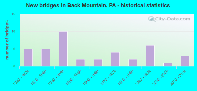
- New bridges - historical statistics
- 51920-1929
- 51930-1939
- 101940-1949
- 21950-1959
- 21960-1969
- 41970-1979
- 21980-1989
- 61990-1999
- 12000-2009
- 32010-2019
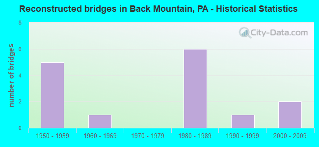
- Reconstructed bridges - Historical Statistics
- 51950-1959
- 11960-1969
- 01970-1979
- 61980-1989
- 11990-1999
- 22000-2009
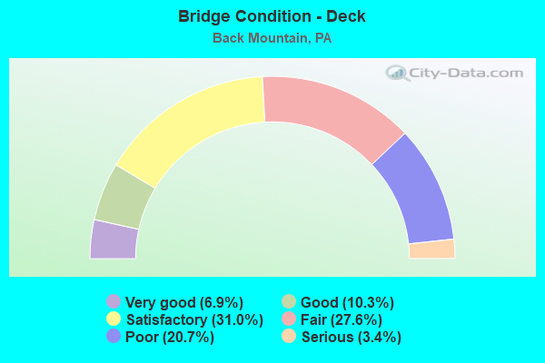
- Bridge Condition - Deck
- 6.9%Very good
- 10.3%Good
- 31.0%Satisfactory
- 27.6%Fair
- 20.7%Poor
- 3.4%Serious
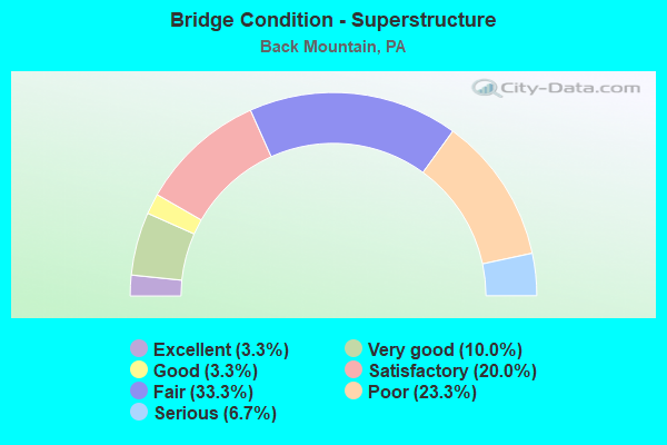
- Bridge Condition - Superstructure
- 3.3%Excellent
- 10.0%Very good
- 3.3%Good
- 20.0%Satisfactory
- 33.3%Fair
- 23.3%Poor
- 6.7%Serious
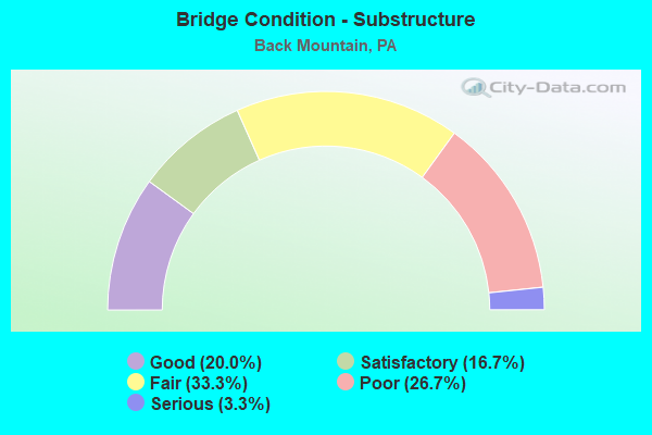
- Bridge Condition - Substructure
- 20.0%Good
- 16.7%Satisfactory
- 33.3%Fair
- 26.7%Poor
- 3.3%Serious
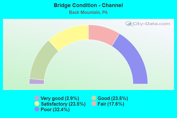
- Bridge Condition - Channel
- 2.9%Very good
- 23.5%Good
- 23.5%Satisfactory
- 17.6%Fair
- 32.4%Poor
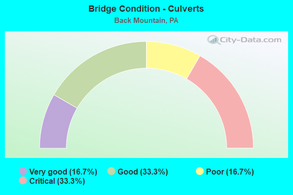
- Bridge Condition - Culverts
- 16.7%Very good
- 33.3%Good
- 16.7%Poor
- 33.3%Critical
Find on map >> Show street view
Structure Number: 5186, Location: SPRING RIDGE DR OVER 222 (Lat: 41.363378, Lng: -75.989250), Route carried "on" structure: State highway , Year Built: 1997, Status: Open, Structure Length: 4.66m (15.29ft), Average Daily Traffic: 11,363 (year 2022), Truck Traffic: 3%, Average Future Daily Traffic: 15,751 (year 2032), Design Load: HS 25 or greater, Features Intersected: US 222 (PARK RD), Facility Carried by Structure: SR3055(SPRNG RIDGE
Minimum Vertical Clearance: 30+ m (98+ ft), Kilometerpoint: 4.535, Lanes on structure: 3, Lanes under structure: 8, Owner: State Highway Agency, Approaching Roadway Width: 13.4m (44.0ft), Skew: 1 degrees, Material/Design: Prestressed concrete, Design/Construction: Box Beam or Girders - Single/Spread, Number Of Spans In Main Unit: 2, Length of Maximum Span: 23.2m (76.1ft), Curb or Sidewalk Widths: Left: 0.2m (0.7ft), Right: 0.2m (0.7ft), Curb-To-Curb Width: 13.4m (44.0ft), Out-to-Out Width: 14.5m (47.6ft)
Condition: Deck: Good, Superstructure: Good, Substructure: Satisfactory, Operating Rating: 84.4 metric tons, Method Used To Determine Operating Rating: Load Factor (LF), Inventory Rating: 46.3 metric tons, Method Used To Determine Inventory Rating: Load Factor (LF), Structural Evaluation: Equal to present minimum criteria, Deck Geometry: Somewhat better than minimum adequacy, Underclear: Better than present minimum criteria, Approach Roadway Alignment: Better than present minimum criteria, Length Of Structure Improvement: 5.50m (18.04ft), Designated Inspection Frequency: Every 48 months, Inspection Date: Febuary 2019, Deck Structure Type: Concrete Cast-file-Place, Wearing Surface/Protective System: Wearing Surface: Monolithic Concrete, Deck Protection: Epoxy Coated Reinforcing
Find on map >> Show street view
Structure Number: 23631, Location: JACKSON TWP 165' S SR1059 (Lat: 41.263692, Lng: -76.033694), Route carried "on" structure: State highway 29, Year Built: 1927, Year Reconstructed: 1980, Status: Open, Structure Length: 2.38m (7.81ft), Average Daily Traffic: 2,004 (year 2020), Truck Traffic: 6%, Average Future Daily Traffic: 3,282 (year 2032), Design Load: H 20, Features Intersected: HARVEYS CREEK
Minimum Vertical Clearance: 30+ m (98+ ft), Kilometerpoint: 15.390, Lanes on structure: 2, Owner: State Highway Agency, Approaching Roadway Width: 8.8m (28.9ft), Skew: 4 degrees, Material/Design: Concrete, Design/Construction: Tee Beam, Number Of Spans In Main Unit: 2, Length of Maximum Span: 11.3m (37.1ft), Curb or Sidewalk Widths: Left: 0.2m (0.7ft), Right: 0.2m (0.7ft), Curb-To-Curb Width: 11.0m (36.1ft), Out-to-Out Width: 12.0m (39.4ft)
Condition: Deck: Poor, Superstructure: Fair, Substructure: Fair, Channel: Satisfactory, Operating Rating: 38.1 metric tons, Method Used To Determine Operating Rating: Load Factor (LF), Inventory Rating: 22.7 metric tons, Method Used To Determine Inventory Rating: Load Factor (LF), Structural Evaluation: Somewhat better than minimum adequacy, Deck Geometry: Somewhat better than minimum adequacy, Waterway Adequacy: Equal to present minimum criteria, Approach Roadway Alignment: Equal to present desirable criteria, Length Of Structure Improvement: 2.41m (7.91ft), Designated Inspection Frequency: Every 24 months, Inspection Date: November 2020, Bridge Improvement Cost: $22,000, Roadway Improvement Cost: $100,000, Total Project Cost: $295,000, Deck Structure Type: Concrete Cast-file-Place, Wearing Surface/Protective System: Wearing Surface: Latex Concrete
Find on map >> Show street view
Structure Number: 23632, Location: PLYMOUTH TWP .3M N SR1059 (Lat: 41.265489, Lng: -76.040872), Route carried "on" structure: State highway 29, Year Built: 1932, Status: Open, Structure Length: 0.82m (2.69ft), Average Daily Traffic: 2,597 (year 2020), Truck Traffic: 6%, Average Future Daily Traffic: 3,365 (year 2032), Design Load: H 20, Features Intersected: CEASETOWN DAM OUTLET
Minimum Vertical Clearance: 30+ m (98+ ft), Kilometerpoint: 16.497, Lanes on structure: 2, Owner: State Highway Agency, Approaching Roadway Width: 8.5m (27.9ft), Skew: 4 degrees, Material/Design: Concrete, Design/Construction: Slab, Number Of Spans In Main Unit: 1, Length of Maximum Span: 7.6m (24.9ft), Curb or Sidewalk Widths: Left: 0.1m (0.3ft), Right: 0.1m (0.3ft), Curb-To-Curb Width: 9.1m (29.9ft), Out-to-Out Width: 10.0m (32.8ft)
Condition: Deck: Poor, Superstructure: Fair, Substructure: Fair, Channel: Good, Operating Rating: 49.0 metric tons, Method Used To Determine Operating Rating: Field evaluation and documented engineering judgment, Inventory Rating: 32.7 metric tons, Method Used To Determine Inventory Rating: Field evaluation and documented engineering judgment, Structural Evaluation: Somewhat better than minimum adequacy, Deck Geometry: Meets minimum limits, Waterway Adequacy: Equal to present desirable criteria, Approach Roadway Alignment: Equal to present desirable criteria, Length Of Structure Improvement: 0.79m (2.59ft), Designated Inspection Frequency: Every 24 months, Inspection Date: November 2020, Bridge Improvement Cost: $14,000, Roadway Improvement Cost: $100,000, Total Project Cost: $190,000, Wearing Surface/Protective System: Wearing Surface: Latex Concrete
Find on map >> Show street view
Structure Number: 23636, Location: LEHMAN TWP 1 M S TR 118 (Lat: 41.290581, Lng: -76.091219), Route carried "on" structure: State highway 29, Year Built: 1927, Year Reconstructed: 1980, Status: Open, Structure Length: 1.19m (3.90ft), Average Daily Traffic: 2,522 (year 2021), Truck Traffic: 11%, Average Future Daily Traffic: 3,150 (year 2032), Design Load: HS 20, Features Intersected: PIKES CREEK
Minimum Vertical Clearance: 30+ m (98+ ft), Kilometerpoint: 22.491, Lanes on structure: 2, Owner: State Highway Agency, Approaching Roadway Width: 7.9m (25.9ft), Skew: 2 degrees, Material/Design: Concrete, Design/Construction: Slab, Number Of Spans In Main Unit: 1, Length of Maximum Span: 11.6m (38.1ft), Curb or Sidewalk Widths: Left: 0.2m (0.7ft), Right: 0.2m (0.7ft), Curb-To-Curb Width: 11.0m (36.1ft), Out-to-Out Width: 12.0m (39.4ft)
Condition: Deck: Satisfactory, Superstructure: Satisfactory, Substructure: Satisfactory, Channel: Satisfactory, Operating Rating: 77.1 metric tons, Method Used To Determine Operating Rating: Load Factor (LF), Inventory Rating: 46.3 metric tons, Method Used To Determine Inventory Rating: Load Factor (LF), Structural Evaluation: Equal to present minimum criteria, Deck Geometry: Somewhat better than minimum adequacy, Waterway Adequacy: Equal to present minimum criteria, Approach Roadway Alignment: Equal to present desirable criteria, Length Of Structure Improvement: 1.20m (3.94ft), Designated Inspection Frequency: Every 48 months, Inspection Date: November 2018, Bridge Improvement Cost: $12,000, Roadway Improvement Cost: $100,000, Total Project Cost: $156,000, Wearing Surface/Protective System: Wearing Surface: Monolithic Concrete, Deck Protection: Epoxy Coated Reinforcing
Find on map >> Show street view
Structure Number: 23637, Location: LAKE TWP .3 M S TR 118 (Lat: 41.301506, Lng: -76.095086), Route carried "on" structure: State highway 29, Year Built: 1932, Year Reconstructed: 2014, Status: Open, Structure Length: 0.70m (2.30ft), Average Daily Traffic: 2,522 (year 2021), Truck Traffic: 11%, Average Future Daily Traffic: 3,150 (year 2032), Design Load: H 20, Features Intersected: PIKES CREEK
Minimum Vertical Clearance: 30+ m (98+ ft), Kilometerpoint: 24.280, Lanes on structure: 2, Owner: State Highway Agency, Approaching Roadway Width: 7.6m (24.9ft), Material/Design: Concrete, Design/Construction: Slab, Number Of Spans In Main Unit: 1, Length of Maximum Span: 6.7m (22.0ft), Curb-To-Curb Width: 9.1m (29.9ft), Out-to-Out Width: 10.2m (33.5ft)
Condition: Deck: Very good, Superstructure: Very good, Substructure: Good, Channel: Satisfactory, Operating Rating: 74.4 metric tons, Method Used To Determine Operating Rating: Load Factor (LF), Inventory Rating: 44.5 metric tons, Method Used To Determine Inventory Rating: Load Factor (LF), Structural Evaluation: Better than present minimum criteria, Deck Geometry: Meets minimum limits, Waterway Adequacy: Equal to present minimum criteria, Approach Roadway Alignment: Equal to present desirable criteria, Length Of Structure Improvement: 0.70m (2.30ft), Designated Inspection Frequency: Every 48 months, Inspection Date: November 2018, Bridge Improvement Cost: $13,000, Roadway Improvement Cost: $100,000, Total Project Cost: $176,000, Deck Structure Type: Concrete Cast-file-Place, Wearing Surface/Protective System: Wearing Surface: Monolithic Concrete, Deck Protection: Epoxy Coated Reinforcing
Find on map >> Show street view
Structure Number: 23819, Location: LAKE TWP .1 M W TR 29 (Lat: 41.305547, Lng: -76.098994), Route carried "on" structure: State highway 118, Year Built: 1932, Year Reconstructed: 1960, Status: Posted for load, Structure Length: 0.67m (2.20ft), Average Daily Traffic: 4,606 (year 2022), Truck Traffic: 11%, Average Future Daily Traffic: 6,010 (year 2032), Design Load: H 20, Features Intersected: FADES CREEK
Minimum Vertical Clearance: 30+ m (98+ ft), Kilometerpoint: 18.147, Lanes on structure: 2, Base Highway Network: Yes, Owner: State Highway Agency, Approaching Roadway Width: 7.9m (25.9ft), Skew: 3 degrees, Material/Design: Concrete, Design/Construction: Slab, Number Of Spans In Main Unit: 1, Length of Maximum Span: 6.1m (20.0ft), Curb or Sidewalk Widths: Left: 0.2m (0.7ft), Right: 0.2m (0.7ft), Curb-To-Curb Width: 11.7m (38.4ft), Out-to-Out Width: 12.9m (42.3ft)
Condition: Deck: Poor, Superstructure: Poor, Substructure: Fair, Channel: Poor, Operating Rating: 39.0 metric tons, Method Used To Determine Operating Rating: Load Factor (LF), Inventory Rating: 23.6 metric tons, Method Used To Determine Inventory Rating: Load Factor (LF), Structural Evaluation: Meets minimum limits, Deck Geometry: Somewhat better than minimum adequacy, Waterway Adequacy: Equal to present minimum criteria, Approach Roadway Alignment: Equal to present desirable criteria, Bridge Posting: Required (Relationship of Operating Rating to Maximum Legal Load: 10.0 - 19.9% below), Length Of Structure Improvement: 0.70m (2.30ft), Designated Inspection Frequency: Every 24 months, Other Special Inspection Frequency: Every 6 months, Inspection Date: October 2020, Other Special Inspection Date: October 2021, Bridge Improvement Cost: $12,000, Roadway Improvement Cost: $100,000, Total Project Cost: $161,000, Wearing Surface/Protective System: Wearing Surface: Bituminous
Find on map >> Show street view
Structure Number: 2382, Location: LAKE TWP .1 M E TR 29 (Lat: 41.305633, Lng: -76.092503), Route carried "on" structure: State highway 118, Year Built: 1935, Status: Open, Structure Length: 0.64m (2.10ft), Average Daily Traffic: 7,377 (year 2022), Truck Traffic: 6%, Average Future Daily Traffic: 10,439 (year 2032), Design Load: H 20, Features Intersected: PIKES CREEK
Minimum Vertical Clearance: 30+ m (98+ ft), Kilometerpoint: 19.068, Lanes on structure: 2, Base Highway Network: Yes, Owner: State Highway Agency, Approaching Roadway Width: 8.8m (28.9ft), Material/Design: Concrete, Design/Construction: Slab, Number Of Spans In Main Unit: 1, Length of Maximum Span: 5.8m (19.0ft), Curb-To-Curb Width: 9.7m (31.8ft), Out-to-Out Width: 11.3m (37.1ft)
Condition: Deck: Fair, Superstructure: Fair, Substructure: Fair, Channel: Poor, Operating Rating: 58.1 metric tons, Method Used To Determine Operating Rating: Load Factor (LF), Inventory Rating: 34.5 metric tons, Method Used To Determine Inventory Rating: Load Factor (LF), Structural Evaluation: Somewhat better than minimum adequacy, Deck Geometry: High priority of corrective action, Waterway Adequacy: Equal to present minimum criteria, Approach Roadway Alignment: Equal to present desirable criteria, Length Of Structure Improvement: 0.60m (1.97ft), Designated Inspection Frequency: Every 24 months, Inspection Date: September 2020, Bridge Improvement Cost: $17,000, Roadway Improvement Cost: $100,000, Total Project Cost: $233,000 ( Estimate for 2030), Wearing Surface/Protective System: Wearing Surface: Bituminous
Find on map >> Show street view
Structure Number: 23821, Location: LEHMAN TWP .8 M W SR 1059 (Lat: 41.308703, Lng: -76.062192), Route carried "on" structure: State highway 118, Year Built: 1935, Year Reconstructed: 1980, Status: Open, Structure Length: 1.71m (5.61ft), Average Daily Traffic: 7,377 (year 2022), Truck Traffic: 6%, Average Future Daily Traffic: 10,439 (year 2032), Design Load: H 20, Features Intersected: HARVEYS CREEK
Minimum Vertical Clearance: 30+ m (98+ ft), Kilometerpoint: 21.607, Lanes on structure: 2, Base Highway Network: Yes, Owner: State Highway Agency, Approaching Roadway Width: 9.1m (29.9ft), Skew: 4 degrees, Material/Design: Concrete, Design/Construction: Tee Beam, Number Of Spans In Main Unit: 2, Length of Maximum Span: 7.9m (25.9ft), Curb or Sidewalk Widths: Left: 0.2m (0.7ft), Right: 0.2m (0.7ft), Curb-To-Curb Width: 10.2m (33.5ft), Out-to-Out Width: 11.5m (37.7ft)
Condition: Deck: Satisfactory, Superstructure: Fair, Substructure: Poor, Channel: Poor, Operating Rating: 58.1 metric tons, Method Used To Determine Operating Rating: Load Factor (LF), Inventory Rating: 34.5 metric tons, Method Used To Determine Inventory Rating: Load Factor (LF), Structural Evaluation: Meets minimum limits, Deck Geometry: Meets minimum limits, Waterway Adequacy: Superior to present desirable criteria, Approach Roadway Alignment: Better than present minimum criteria, Length Of Structure Improvement: 1.70m (5.58ft), Designated Inspection Frequency: Every 24 months, Inspection Date: September 2020, Bridge Improvement Cost: $17,000, Roadway Improvement Cost: $100,000, Total Project Cost: $230,000, Deck Structure Type: Concrete Cast-file-Place, Wearing Surface/Protective System: Wearing Surface: Bituminous
Find on map >> Show street view
Structure Number: 23895, Location: KINGSTON TWP .1M S SR1036 (Lat: 41.301419, Lng: -75.927644), Route carried "on" structure: State highway 309, Year Built: 1928, Year Reconstructed: 1963, Status: Open, Structure Length: 1.31m (4.30ft), Average Daily Traffic: 34,200 (year 2022), Truck Traffic: 4%, Average Future Daily Traffic: 43,444 (year 2032), Design Load: HS 20, Features Intersected: TOBY'S CREEK
Minimum Vertical Clearance: 30+ m (98+ ft), Kilometerpoint: 49.560, Lanes on structure: 4, Base Highway Network: Yes, Owner: State Highway Agency, Approaching Roadway Width: 18.0m (59.1ft), Skew: 24 degrees, Material/Design: Concrete, Design/Construction: Tee Beam, Number Of Spans In Main Unit: 1, Length of Maximum Span: 12.5m (41.0ft), Curb or Sidewalk Widths: Left: 1.1m (3.6ft), Right: 0.2m (0.7ft), Curb-To-Curb Width: 18.6m (61.0ft), Out-to-Out Width: 21.0m (68.9ft)
Condition: Deck: Poor, Superstructure: Poor, Substructure: Fair, Channel: Satisfactory, Operating Rating: 64.4 metric tons, Method Used To Determine Operating Rating: Load Factor (LF), Inventory Rating: 37.2 metric tons, Method Used To Determine Inventory Rating: Load Factor (LF), Structural Evaluation: Meets minimum limits, Deck Geometry: Equal to present minimum criteria, Waterway Adequacy: Equal to present desirable criteria, Approach Roadway Alignment: Equal to present desirable criteria, Length Of Structure Improvement: 1.40m (4.59ft), Designated Inspection Frequency: Every 24 months, Inspection Date: October 2020, Bridge Improvement Cost: $34,000, Roadway Improvement Cost: $100,000, Total Project Cost: $456,000, Deck Structure Type: Concrete Cast-file-Place, Wearing Surface/Protective System: Wearing Surface: Bituminous
Find on map >> Show street view
Structure Number: 23896, Location: KINGSTON TWP 1M S SR 1014 (Lat: 41.307658, Lng: -75.934147), Route carried "on" structure: State highway 309, Year Built: 1941, Year Reconstructed: 1963, Status: Open, Structure Length: 2.07m (6.79ft), Average Daily Traffic: 28,744 (year 2022), Truck Traffic: 6%, Average Future Daily Traffic: 38,333 (year 2032), Design Load: HS 20, Features Intersected: TOBY CREEK
Minimum Vertical Clearance: 30+ m (98+ ft), Kilometerpoint: 50.672, Lanes on structure: 5, Base Highway Network: Yes, Owner: State Highway Agency, Approaching Roadway Width: 21.0m (68.9ft), Skew: 24 degrees, Material/Design: Concrete, Design/Construction: Tee Beam, Number Of Spans In Main Unit: 2, Length of Maximum Span: 9.1m (29.9ft), Curb or Sidewalk Widths: Left: 0.2m (0.7ft), Right: 0.2m (0.7ft), Curb-To-Curb Width: 20.2m (66.3ft), Out-to-Out Width: 21.7m (71.2ft)
Condition: Deck: Fair, Superstructure: Fair, Substructure: Poor, Channel: Poor, Operating Rating: 62.6 metric tons, Method Used To Determine Operating Rating: Load Factor (LF), Inventory Rating: 37.2 metric tons, Method Used To Determine Inventory Rating: Load Factor (LF), Structural Evaluation: Meets minimum limits, Deck Geometry: Somewhat better than minimum adequacy, Waterway Adequacy: Equal to present minimum criteria, Approach Roadway Alignment: Equal to present desirable criteria, Length Of Structure Improvement: 2.10m (6.89ft), Designated Inspection Frequency: Every 24 months, Inspection Date: October 2020, Bridge Improvement Cost: $121,000, Roadway Improvement Cost: $593,000, Total Project Cost: $1,629,000, Deck Structure Type: Concrete Cast-file-Place, Wearing Surface/Protective System: Wearing Surface: Bituminous, Membrane: Preformed Fabric
Find on map >> Show street view
Structure Number: 23897, Location: KINGSTON TP .8M S SR 1014 (Lat: 41.309736, Lng: -75.934739), Route carried "on" structure: State highway 309, Year Built: 1941, Year Reconstructed: 1963, Status: Open, Structure Length: 1.71m (5.61ft), Average Daily Traffic: 28,744 (year 2022), Truck Traffic: 6%, Average Future Daily Traffic: 38,333 (year 2032), Design Load: HS 20, Features Intersected: TOBY CREEK
Minimum Vertical Clearance: 30+ m (98+ ft), Kilometerpoint: 50.672, Lanes on structure: 5, Base Highway Network: Yes, Owner: State Highway Agency, Approaching Roadway Width: 21.0m (68.9ft), Skew: 23 degrees, Material/Design: Concrete, Design/Construction: Tee Beam, Number Of Spans In Main Unit: 2, Length of Maximum Span: 7.9m (25.9ft), Curb or Sidewalk Widths: Left: 0.2m (0.7ft), Right: 0.2m (0.7ft), Curb-To-Curb Width: 20.6m (67.6ft), Out-to-Out Width: 22.1m (72.5ft)
Condition: Deck: Satisfactory, Superstructure: Poor, Substructure: Fair, Channel: Poor, Operating Rating: 60.8 metric tons, Method Used To Determine Operating Rating: Load Factor (LF), Inventory Rating: 37.2 metric tons, Method Used To Determine Inventory Rating: Load Factor (LF), Structural Evaluation: Meets minimum limits, Deck Geometry: Somewhat better than minimum adequacy, Waterway Adequacy: Equal to present desirable criteria, Approach Roadway Alignment: Equal to present desirable criteria, Length Of Structure Improvement: 2.30m (7.55ft), Designated Inspection Frequency: Every 24 months, Inspection Date: October 2020, Bridge Improvement Cost: $103,000, Roadway Improvement Cost: $498,000, Total Project Cost: $1,389,000, Deck Structure Type: Concrete Cast-file-Place, Wearing Surface/Protective System: Wearing Surface: Bituminous
Find on map >> Show street view
Structure Number: 23898, Location: KINGSTON TP .7M S SR 1014 (Lat: 41.316242, Lng: -75.939097), Route carried "on" structure: State highway 309, Year Built: 1941, Year Reconstructed: 1963, Status: Open, Structure Length: 1.37m (4.49ft), Average Daily Traffic: 28,744 (year 2022), Truck Traffic: 6%, Average Future Daily Traffic: 38,333 (year 2032), Design Load: HS 20, Features Intersected: TOBY CREEK
Minimum Vertical Clearance: 30+ m (98+ ft), Kilometerpoint: 51.544, Lanes on structure: 3, Base Highway Network: Yes, Owner: State Highway Agency, Approaching Roadway Width: 20.1m (65.9ft), Skew: 6 degrees, Material/Design: Concrete, Design/Construction: Tee Beam, Number Of Spans In Main Unit: 1, Length of Maximum Span: 12.8m (42.0ft), Curb or Sidewalk Widths: Left: 0.2m (0.7ft), Right: 0.2m (0.7ft), Curb-To-Curb Width: 20.8m (68.2ft), Out-to-Out Width: 22.3m (73.2ft)
Condition: Deck: Fair, Superstructure: Satisfactory, Substructure: Poor, Channel: Poor, Operating Rating: 48.1 metric tons, Method Used To Determine Operating Rating: Load Factor (LF), Inventory Rating: 29.0 metric tons, Method Used To Determine Inventory Rating: Load Factor (LF), Structural Evaluation: Meets minimum limits, Deck Geometry: Superior to present desirable criteria, Waterway Adequacy: Equal to present minimum criteria, Approach Roadway Alignment: Equal to present desirable criteria, Length Of Structure Improvement: 1.40m (4.59ft), Designated Inspection Frequency: Every 24 months, Inspection Date: September 2020, Bridge Improvement Cost: $34,000, Roadway Improvement Cost: $101,000, Total Project Cost: $461,000, Deck Structure Type: Concrete Cast-file-Place, Wearing Surface/Protective System: Wearing Surface: Bituminous
Find on map >> Show street view
Structure Number: 23899, Location: KINGSTON TWP .6M S SR1014 (Lat: 41.317622, Lng: -75.939428), Route carried "on" structure: State highway 309, Year Built: 1941, Year Reconstructed: 1963, Status: Open, Structure Length: 1.04m (3.41ft), Average Daily Traffic: 28,744 (year 2022), Truck Traffic: 6%, Average Future Daily Traffic: 38,333 (year 2032), Design Load: HS 20, Features Intersected: TOBY CREEK
Minimum Vertical Clearance: 30+ m (98+ ft), Kilometerpoint: 51.544, Lanes on structure: 5, Base Highway Network: Yes, Owner: State Highway Agency, Approaching Roadway Width: 21.3m (69.9ft), Skew: 24 degrees, Material/Design: Concrete, Design/Construction: Tee Beam, Number Of Spans In Main Unit: 1, Length of Maximum Span: 9.1m (29.9ft), Curb or Sidewalk Widths: Left: 0.2m (0.7ft), Right: 0.2m (0.7ft), Curb-To-Curb Width: 20.9m (68.6ft), Out-to-Out Width: 22.3m (73.2ft)
Condition: Deck: Satisfactory, Superstructure: Satisfactory, Substructure: Fair, Channel: Poor, Operating Rating: 47.2 metric tons, Method Used To Determine Operating Rating: Load Factor (LF), Inventory Rating: 28.1 metric tons, Method Used To Determine Inventory Rating: Load Factor (LF), Structural Evaluation: Somewhat better than minimum adequacy, Deck Geometry: Somewhat better than minimum adequacy, Waterway Adequacy: Equal to present minimum criteria, Approach Roadway Alignment: Equal to present desirable criteria, Length Of Structure Improvement: 1.00m (3.28ft), Designated Inspection Frequency: Every 24 months, Inspection Date: October 2020, Bridge Improvement Cost: $18,000, Roadway Improvement Cost: $100,000, Total Project Cost: $245,000, Deck Structure Type: Concrete Cast-file-Place, Wearing Surface/Protective System: Wearing Surface: Bituminous
Find on map >> Show street view
Structure Number: 23907, Location: DALLAS TWP .1 M N SR 1026 (Lat: 41.380214, Lng: -75.982356), Route carried "on" structure: State highway 309, Year Built: 1940, Status: Open, Structure Length: 0.98m (3.22ft), Average Daily Traffic: 7,236 (year 2022), Truck Traffic: 12%, Average Future Daily Traffic: 10,033 (year 2032), Design Load: H 20, Features Intersected: LEONARDS CREEK
Minimum Vertical Clearance: 30+ m (98+ ft), Kilometerpoint: 60.424, Lanes on structure: 2, Base Highway Network: Yes, Owner: State Highway Agency, Approaching Roadway Width: 10.7m (35.1ft), Skew: 3 degrees, Material/Design: Concrete, Design/Construction: Tee Beam, Number Of Spans In Main Unit: 1, Length of Maximum Span: 9.1m (29.9ft), Curb or Sidewalk Widths: Left: 0.2m (0.7ft), Right: 0.2m (0.7ft), Curb-To-Curb Width: 11.1m (36.4ft), Out-to-Out Width: 12.3m (40.4ft)
Condition: Deck: Poor, Superstructure: Poor, Substructure: Poor, Channel: Poor, Operating Rating: 55.3 metric tons, Method Used To Determine Operating Rating: Load Factor (LF), Inventory Rating: 32.7 metric tons, Method Used To Determine Inventory Rating: Load Factor (LF), Structural Evaluation: Meets minimum limits, Deck Geometry: Meets minimum limits, Waterway Adequacy: Equal to present minimum criteria, Approach Roadway Alignment: Equal to present desirable criteria, Length Of Structure Improvement: 0.90m (2.95ft), Designated Inspection Frequency: Every 24 months, Other Special Inspection Frequency: Every 6 months, Inspection Date: September 2020, Other Special Inspection Date: September 2021, Bridge Improvement Cost: $19,000, Roadway Improvement Cost: $100,000, Total Project Cost: $258,000, Deck Structure Type: Concrete Cast-file-Place, Wearing Surface/Protective System: Wearing Surface: Bituminous
Find on map >> Show street view
Structure Number: 23979, Location: DALLAS TWP OVER TR 309 (Lat: 41.325836, Lng: -75.945228), Route carried "on" structure: State highway , Year Built: 1940, Status: Open, Structure Length: 2.07m (6.79ft), Average Daily Traffic: 1,423 (year 2022), Truck Traffic: 3%, Average Future Daily Traffic: 2,558 (year 2032), Design Load: H 20, Features Intersected: SR 0309 TR 309, Facility Carried by Structure: SR1014 OVERLOOK RD
Minimum Vertical Clearance: 30+ m (98+ ft), Kilometerpoint: 2.799, Lanes on structure: 2, Lanes under structure: 4, Owner: State Highway Agency, Approaching Roadway Width: 7.6m (24.9ft), Skew: 1 degrees, Material/Design: Steel, Design/Construction: Stringer/Multi-beam, Number Of Spans In Main Unit: 1, Length of Maximum Span: 19.5m (64.0ft), Curb or Sidewalk Widths: Left: 0.2m (0.7ft), Right: 0.2m (0.7ft), Curb-To-Curb Width: 7.4m (24.3ft), Out-to-Out Width: 8.4m (27.6ft)
Condition: Deck: Serious, Superstructure: Fair, Substructure: Poor, Operating Rating: 49.0 metric tons, Method Used To Determine Operating Rating: Load Factor (LF), Inventory Rating: 29.0 metric tons, Method Used To Determine Inventory Rating: Load Factor (LF), Structural Evaluation: Meets minimum limits, Deck Geometry: Meets minimum limits, Underclear: High priority of corrective action, Approach Roadway Alignment: Equal to present desirable criteria, Length Of Structure Improvement: 2.00m (6.56ft), Designated Inspection Frequency: Every 24 months, Inspection Date: November 2020, Bridge Improvement Cost: $27,000, Roadway Improvement Cost: $100,000, Total Project Cost: $360,000, Deck Structure Type: Concrete Cast-file-Place, Wearing Surface/Protective System: Wearing Surface: Bituminous
Find on map >> Show street view
Structure Number: 23999, Location: DALLAS TWP 300' W TR 309 (Lat: 41.377806, Lng: -75.983514), Route carried "on" structure: State highway , Year Built: 1940, Status: Open, Structure Length: 1.13m (3.71ft), Average Daily Traffic: 1,975 (year 2022), Truck Traffic: 9%, Average Future Daily Traffic: 2,716 (year 2032), Design Load: HS 20, Features Intersected: LEONARD CREEK, Facility Carried by Structure: SR 1026 KUNKLE RD
Minimum Vertical Clearance: 30+ m (98+ ft), Kilometerpoint: 4.099, Lanes on structure: 2, Owner: State Highway Agency, Approaching Roadway Width: 7.0m (23.0ft), Skew: 3 degrees, Material/Design: Concrete, Design/Construction: Tee Beam, Number Of Spans In Main Unit: 1, Length of Maximum Span: 10.4m (34.1ft), Curb or Sidewalk Widths: Left: 0.2m (0.7ft), Right: 0.2m (0.7ft), Curb-To-Curb Width: 9.1m (29.9ft), Out-to-Out Width: 10.2m (33.5ft)
Condition: Deck: Satisfactory, Superstructure: Satisfactory, Substructure: Satisfactory, Channel: Good, Operating Rating: 46.3 metric tons, Method Used To Determine Operating Rating: Load Factor (LF), Inventory Rating: 27.2 metric tons, Method Used To Determine Inventory Rating: Load Factor (LF), Structural Evaluation: Equal to present minimum criteria, Deck Geometry: Somewhat better than minimum adequacy, Waterway Adequacy: Better than present minimum criteria, Approach Roadway Alignment: Equal to present desirable criteria, Length Of Structure Improvement: 1.40m (4.59ft), Designated Inspection Frequency: Every 24 months, Inspection Date: October 2020, Bridge Improvement Cost: $21,000, Roadway Improvement Cost: $199,000, Total Project Cost: $288,000, Deck Structure Type: Concrete Cast-file-Place, Wearing Surface/Protective System: Wearing Surface: Bituminous
Find on map >> Show street view
Structure Number: 24015, Location: KINGSTON TWP JCT TR 309 (Lat: 41.302369, Lng: -75.929053), Route carried "on" structure: State highway , Year Built: 1976, Year Reconstructed: 1997, Status: Open, Structure Length: 0.94m (3.08ft), Average Daily Traffic: 5,439 (year 2022), Truck Traffic: 3%, Average Future Daily Traffic: 8,295 (year 2032), Design Load: HS 20, Features Intersected: TOBY CREEK, Facility Carried by Structure: SR 1036 CAVERTON R
Minimum Vertical Clearance: 30+ m (98+ ft), Kilometerpoint: 0.000, Lanes on structure: 3, Owner: State Highway Agency, Approaching Roadway Width: 8.5m (27.9ft), Skew: 1 degrees, Material/Design: Prestressed concrete, Design/Construction: Box Beam or Girders - Single/Spread, Number Of Spans In Main Unit: 1, Length of Maximum Span: 9.4m (30.8ft), Curb or Sidewalk Widths: Left: 1.5m (4.9ft), Right: 0.2m (0.7ft), Curb-To-Curb Width: 12.8m (42.0ft), Out-to-Out Width: 13.8m (45.3ft)
Condition: Deck: Good, Superstructure: Very good, Substructure: Poor, Channel: Poor, Operating Rating: 68.0 metric tons, Method Used To Determine Operating Rating: Load Factor (LF), Inventory Rating: 40.8 metric tons, Method Used To Determine Inventory Rating: Load Factor (LF), Structural Evaluation: Meets minimum limits, Deck Geometry: Meets minimum limits, Waterway Adequacy: Superior to present desirable criteria, Approach Roadway Alignment: Equal to present desirable criteria, Length Of Structure Improvement: 1.00m (3.28ft), Designated Inspection Frequency: Every 24 months, Inspection Date: September 2020, Bridge Improvement Cost: $14,000, Roadway Improvement Cost: $100,000, Total Project Cost: $187,000, Deck Structure Type: Concrete Cast-file-Place, Wearing Surface/Protective System: Wearing Surface: Monolithic Concrete, Deck Protection: Epoxy Coated Reinforcing
Find on map >> Show street view
Structure Number: 24019, Location: KINGSTON TP .1M W SR 1021 (Lat: 41.336817, Lng: -75.868825), Route carried "on" structure: State highway , Year Built: 1976, Status: Open, Structure Length: 1.28m (4.20ft), Average Daily Traffic: 3,887 (year 2021), Truck Traffic: 2%, Average Future Daily Traffic: 5,123 (year 2032), Design Load: HS 20+Mod, Features Intersected: ABRAHAMS CREEK, Facility Carried by Structure: SR1036,CARVERTONRD
Minimum Vertical Clearance: 30+ m (98+ ft), Kilometerpoint: 6.104, Lanes on structure: 2, Base Highway Network: Yes, Owner: State Highway Agency, Approaching Roadway Width: 13.4m (44.0ft), Skew: 4 degrees, Material/Design: Prestressed concrete, Design/Construction: Box Beam or Girders - Single/Spread, Number Of Spans In Main Unit: 1, Length of Maximum Span: 12.5m (41.0ft), Curb or Sidewalk Widths: Left: 0.2m (0.7ft), Right: 0.2m (0.7ft), Curb-To-Curb Width: 13.4m (44.0ft), Out-to-Out Width: 14.6m (47.9ft)
Condition: Deck: Fair, Superstructure: Poor, Substructure: Satisfactory, Channel: Fair, Operating Rating: 78.9 metric tons, Method Used To Determine Operating Rating: Load Factor (LF), Inventory Rating: 35.4 metric tons, Method Used To Determine Inventory Rating: Load Factor (LF), Structural Evaluation: Meets minimum limits, Deck Geometry: Better than present minimum criteria, Waterway Adequacy: Equal to present minimum criteria, Approach Roadway Alignment: Better than present minimum criteria, Length Of Structure Improvement: 1.90m (6.23ft), Designated Inspection Frequency: Every 24 months, Inspection Date: September 2020, Deck Structure Type: Concrete Cast-file-Place, Wearing Surface/Protective System: Wearing Surface: Monolithic Concrete, Deck Protection: Galvanized Reinforcing
Find on map >> Show street view
Structure Number: 2402, Location: FRKLIN TP AT LAKE LOUISE (Lat: 41.381564, Lng: -75.906822), Route carried "on" structure: State highway , Year Built: 1940, Status: Open, Structure Length: 1.10m (3.61ft), Average Daily Traffic: 661 (year 2022), Truck Traffic: 7%, Average Future Daily Traffic: 887 (year 2032), Features Intersected: SUTTONS CREEK, Facility Carried by Structure: SR 1037
Minimum Vertical Clearance: 30+ m (98+ ft), Kilometerpoint: 1.537, Lanes on structure: 2, Owner: State Highway Agency, Approaching Roadway Width: 6.1m (20.0ft), Material/Design: Concrete continuous, Design/Construction: Slab, Number Of Spans In Main Unit: 2, Length of Maximum Span: 4.9m (16.1ft), Curb or Sidewalk Widths: Left: 0.2m (0.7ft), Right: 0.2m (0.7ft), Curb-To-Curb Width: 7.0m (23.0ft), Out-to-Out Width: 8.0m (26.2ft)
Condition: Deck: Fair, Superstructure: Fair, Substructure: Fair, Channel: Good, Operating Rating: 49.0 metric tons, Method Used To Determine Operating Rating: Field evaluation and documented engineering judgment, Inventory Rating: 32.7 metric tons, Method Used To Determine Inventory Rating: Field evaluation and documented engineering judgment, Structural Evaluation: Somewhat better than minimum adequacy, Deck Geometry: Meets minimum limits, Waterway Adequacy: Superior to present desirable criteria, Approach Roadway Alignment: Equal to present desirable criteria, Length Of Structure Improvement: 1.10m (3.61ft), Designated Inspection Frequency: Every 24 months, Inspection Date: September 2020, Bridge Improvement Cost: $21,000, Roadway Improvement Cost: $100,000, Total Project Cost: $278,000, Wearing Surface/Protective System: Wearing Surface: Bituminous
Find on map >> Show street view
Structure Number: 24026, Location: KINGSTON TP 1 M E SR 1029 (Lat: 41.344722, Lng: -75.900306), Route carried "on" structure: State highway , Year Built: 1965, Status: Open, Structure Length: 0.67m (2.20ft), Average Daily Traffic: 1,838 (year 2022), Truck Traffic: 1%, Average Future Daily Traffic: 2,295 (year 2037), Design Load: HS 20, Features Intersected: ABRAHAMS CREEK, Facility Carried by Structure: SR 1044
Minimum Vertical Clearance: 30+ m (98+ ft), Kilometerpoint: 6.848, Lanes on structure: 2, Owner: State Highway Agency, Approaching Roadway Width: 6.4m (21.0ft), Skew: 4 degrees, Material/Design: Steel, Design/Construction: Culvert, Number Of Spans In Main Unit: 1, Length of Maximum Span: 6.7m (22.0ft)
Condition: Channel: Fair, Culverts: Critical, Operating Rating: 49.0 metric tons, Method Used To Determine Operating Rating: Field evaluation and documented engineering judgment, Inventory Rating: 29.0 metric tons, Method Used To Determine Inventory Rating: Field evaluation and documented engineering judgment, Structural Evaluation: High priority of replacement, Waterway Adequacy: Equal to present minimum criteria, Approach Roadway Alignment: Equal to present desirable criteria, Length Of Structure Improvement: 0.70m (2.30ft), Designated Inspection Frequency: Every 24 months, Other Special Inspection Frequency: Every 6 months, Inspection Date: September 2020, Other Special Inspection Date: September 2021, Bridge Improvement Cost: $26,000, Roadway Improvement Cost: $100,000, Total Project Cost: $350,000
Find on map >> Show street view
Structure Number: 24036, Location: LEHMAN TWP .1 M S SR 1051 (Lat: 41.310897, Lng: -76.066967), Route carried "on" structure: State highway , Year Built: 1977, Status: Open, Structure Length: 0.67m (2.20ft), Average Daily Traffic: 308 (year 2020), Truck Traffic: 9%, Average Future Daily Traffic: 423 (year 2032), Design Load: HS 20, Features Intersected: HARVEYS CREEK, Facility Carried by Structure: SR 1048 MEEKER RD
Minimum Vertical Clearance: 30+ m (98+ ft), Kilometerpoint: 0.000, Lanes on structure: 2, Owner: State Highway Agency, Approaching Roadway Width: 6.7m (22.0ft), Material/Design: Steel, Design/Construction: Culvert, Number Of Spans In Main Unit: 4, Length of Maximum Span: 1.8m (5.9ft)
Condition: Channel: Fair, Culverts: Critical, Operating Rating: 40.8 metric tons, Method Used To Determine Operating Rating: Field evaluation and documented engineering judgment, Inventory Rating: 24.5 metric tons, Method Used To Determine Inventory Rating: Field evaluation and documented engineering judgment, Structural Evaluation: High priority of replacement, Waterway Adequacy: Better than present minimum criteria, Approach Roadway Alignment: Equal to present desirable criteria, Length Of Structure Improvement: 1.10m (3.61ft), Designated Inspection Frequency: Every 24 months, Other Special Inspection Frequency: Every 6 months, Inspection Date: October 2020, Other Special Inspection Date: October 2021, Bridge Improvement Cost: $36,000, Roadway Improvement Cost: $105,000, Total Project Cost: $481,000
Find on map >> Show street view
Structure Number: 24037, Location: LEHMAN TWP .5 M W TR 118 (Lat: 41.310944, Lng: -76.067331), Route carried "on" structure: State highway , Year Built: 1956, Status: Open, Structure Length: 1.13m (3.71ft), Average Daily Traffic: 308 (year 2020), Truck Traffic: 9%, Average Future Daily Traffic: 423 (year 2032), Design Load: HS 20, Features Intersected: BRANCH HARVEY CREEK, Facility Carried by Structure: SR 1048 MEEKER RD
Minimum Vertical Clearance: 30+ m (98+ ft), Kilometerpoint: 0.010, Lanes on structure: 2, Owner: State Highway Agency, Approaching Roadway Width: 5.8m (19.0ft), Material/Design: Steel, Design/Construction: Stringer/Multi-beam, Number Of Spans In Main Unit: 1, Length of Maximum Span: 11.0m (36.1ft), Curb or Sidewalk Widths: Left: 0.3m (1.0ft), Right: 0.3m (1.0ft), Curb-To-Curb Width: 7.4m (24.3ft), Out-to-Out Width: 8.0m (26.2ft)
Condition: Deck: Satisfactory, Superstructure: Fair, Substructure: Poor, Channel: Poor, Operating Rating: 62.6 metric tons, Method Used To Determine Operating Rating: Load Factor (LF), Inventory Rating: 37.2 metric tons, Method Used To Determine Inventory Rating: Load Factor (LF), Structural Evaluation: Meets minimum limits, Deck Geometry: Somewhat better than minimum adequacy, Waterway Adequacy: Better than present minimum criteria, Approach Roadway Alignment: Better than present minimum criteria, Length Of Structure Improvement: 1.30m (4.27ft), Designated Inspection Frequency: Every 24 months, Inspection Date: November 2020, Bridge Improvement Cost: $11,000, Roadway Improvement Cost: $100,000, Total Project Cost: $150,000, Deck Structure Type: Concrete Cast-file-Place, Wearing Surface/Protective System: Wearing Surface: Bituminous
Find on map >> Show street view
Structure Number: 24038, Location: KINGSTON TP JCT. TR309 (Lat: 41.293906, Lng: -75.921975), Route carried "on" structure: State highway , Year Built: 1963, Status: Open, Structure Length: 1.19m (3.90ft), Average Daily Traffic: 14 (year 2018), Truck Traffic: 9%, Average Future Daily Traffic: 30 (year 2032), Design Load: HS 20, Features Intersected: TOBY CREEK, Facility Carried by Structure: SR 1050 (DEAD END)
Minimum Vertical Clearance: 30+ m (98+ ft), Kilometerpoint: 0.000, Lanes on structure: 2, Owner: State Highway Agency, Approaching Roadway Width: 4.9m (16.1ft), Skew: 1 degrees, Material/Design: Prestressed concrete, Design/Construction: Box Beam or Girders - Multiple, Number Of Spans In Main Unit: 1, Length of Maximum Span: 11.6m (38.1ft), Curb or Sidewalk Widths: Left: 0.3m (1.0ft), Right: 0.3m (1.0ft), Curb-To-Curb Width: 4.9m (16.1ft), Out-to-Out Width: 5.6m (18.4ft)
Condition: Deck: Poor, Superstructure: Poor, Substructure: Good, Channel: Satisfactory, Operating Rating: 54.4 metric tons, Method Used To Determine Operating Rating: Load Factor (LF), Inventory Rating: 24.5 metric tons, Method Used To Determine Inventory Rating: Load Factor (LF), Structural Evaluation: Meets minimum limits, Deck Geometry: High priority of corrective action, Waterway Adequacy: Superior to present desirable criteria, Approach Roadway Alignment: Equal to present desirable criteria, Length Of Structure Improvement: 1.20m (3.94ft), Designated Inspection Frequency: Every 24 months, Inspection Date: October 2020, Bridge Improvement Cost: $11,000, Roadway Improvement Cost: $100,000, Total Project Cost: $145,000, Deck Structure Type: Other, Wearing Surface/Protective System: Wearing Surface: Bituminous
Find on map >> Show street view
Structure Number: 24043, Location: LEHMAN TWP 200' S TR 118 (Lat: 41.292500, Lng: -76.048450), Route carried "on" structure: State highway , Year Built: 1997, Status: Open, Structure Length: 1.22m (4.00ft), Average Daily Traffic: 429 (year 2021), Truck Traffic: 6%, Average Future Daily Traffic: 399 (year 2032), Design Load: HS 20, Features Intersected: HARVEY CREEK, Facility Carried by Structure: SR 1059 FEDOR RD
Minimum Vertical Clearance: 30+ m (98+ ft), Kilometerpoint: 1.466, Lanes on structure: 2, Owner: State Highway Agency, Approaching Roadway Width: 6.1m (20.0ft), Skew: 3 degrees, Material/Design: Prestressed concrete, Design/Construction: Box Beam or Girders - Single/Spread, Number Of Spans In Main Unit: 1, Length of Maximum Span: 11.9m (39.0ft), Curb or Sidewalk Widths: Left: 0.2m (0.7ft), Right: 0.2m (0.7ft), Curb-To-Curb Width: 8.7m (28.5ft), Out-to-Out Width: 9.8m (32.2ft)
Condition: Deck: Good, Superstructure: Very good, Substructure: Good, Channel: Very good, Operating Rating: 78.0 metric tons, Method Used To Determine Operating Rating: Load Factor (LF), Inventory Rating: 35.4 metric tons, Method Used To Determine Inventory Rating: Load Factor (LF), Structural Evaluation: Better than present minimum criteria, Deck Geometry: Somewhat better than minimum adequacy, Waterway Adequacy: Equal to present desirable criteria, Approach Roadway Alignment: Better than present minimum criteria, Length Of Structure Improvement: 1.90m (6.23ft), Designated Inspection Frequency: Every 24 months, Inspection Date: October 2020, Deck Structure Type: Concrete Cast-file-Place, Wearing Surface/Protective System: Wearing Surface: Monolithic Concrete, Deck Protection: Epoxy Coated Reinforcing
Find on map >> Show street view
Structure Number: 24415, Location: 300 FT WEST OF SR 29 (Lat: 41.261239, Lng: -76.029889), Route carried "on" structure: City street , Year Built: 1992, Status: Open, Structure Length: 1.19m (3.90ft), Average Daily Traffic: 210 (year 2012), Average Future Daily Traffic: 280 (year 2032), Design Load: HS 25 or greater, Features Intersected: HARVEYS CREEK, Facility Carried by Structure: T-497 PAVLICK RD
Minimum Vertical Clearance: 30+ m (98+ ft), Kilometerpoint: 0.000, Lanes on structure: 2, Owner: County Highway Agency, Approaching Roadway Width: 7.6m (24.9ft), Material/Design: Prestressed concrete, Design/Construction: Box Beam or Girders - Multiple, Number Of Spans In Main Unit: 1, Length of Maximum Span: 11.3m (37.1ft), Curb or Sidewalk Widths: Left: 0.2m (0.7ft), Right: 0.2m (0.7ft), Curb-To-Curb Width: 7.6m (24.9ft), Out-to-Out Width: 8.6m (28.2ft)
Condition: Deck: Satisfactory, Superstructure: Satisfactory, Substructure: Good, Channel: Good, Operating Rating: 86.2 metric tons, Method Used To Determine Operating Rating: Load Factor (LF), Inventory Rating: 42.6 metric tons, Method Used To Determine Inventory Rating: Load Factor (LF), Structural Evaluation: Equal to present minimum criteria, Deck Geometry: Somewhat better than minimum adequacy, Waterway Adequacy: Better than present minimum criteria, Approach Roadway Alignment: Equal to present desirable criteria, Length Of Structure Improvement: 1.50m (4.92ft), Designated Inspection Frequency: Every 24 months, Inspection Date: October 2020, Bridge Improvement Cost: $23,000, Roadway Improvement Cost: $68,000, Total Project Cost: $311,000, Deck Structure Type: Other, Wearing Surface/Protective System: Wearing Surface: Bituminous, Membrane: Preformed Fabric
Find on map >> Show street view
Structure Number: 24416, Location: 800 FT WEST OF SR 29 (Lat: 41.255844, Lng: -76.012150), Route carried "on" structure: City street , Year Built: 1993, Status: Open, Structure Length: 1.19m (3.90ft), Average Daily Traffic: 200 (year 2012), Average Future Daily Traffic: 260 (year 2032), Features Intersected: HARVEYS CREEK, Facility Carried by Structure: T-499 ZBICK ROAD
Minimum Vertical Clearance: 30+ m (98+ ft), Kilometerpoint: 0.000, Lanes on structure: 2, Owner: County Highway Agency, Approaching Roadway Width: 6.1m (20.0ft), Material/Design: Prestressed concrete, Design/Construction: Box Beam or Girders - Multiple, Number Of Spans In Main Unit: 1, Length of Maximum Span: 11.3m (37.1ft), Curb or Sidewalk Widths: Left: 0.2m (0.7ft), Right: 0.2m (0.7ft), Curb-To-Curb Width: 7.6m (24.9ft), Out-to-Out Width: 8.7m (28.5ft)
Condition: Deck: Fair, Superstructure: Fair, Substructure: Good, Channel: Satisfactory, Operating Rating: 88.0 metric tons, Method Used To Determine Operating Rating: Load Factor (LF), Inventory Rating: 44.5 metric tons, Method Used To Determine Inventory Rating: Load Factor (LF), Structural Evaluation: Somewhat better than minimum adequacy, Deck Geometry: Somewhat better than minimum adequacy, Waterway Adequacy: Superior to present desirable criteria, Approach Roadway Alignment: Equal to present desirable criteria, Length Of Structure Improvement: 1.50m (4.92ft), Designated Inspection Frequency: Every 24 months, Inspection Date: October 2020, Bridge Improvement Cost: $23,000, Roadway Improvement Cost: $68,000, Total Project Cost: $311,000, Deck Structure Type: Other, Wearing Surface/Protective System: Wearing Surface: Bituminous, Membrane: Preformed Fabric
Find on map >> Show street view
Structure Number: 24418, Location: CHASE ROAD INTERSECTION (Lat: 41.259586, Lng: -75.997558), Route carried "on" structure: City street , Year Built: 1927, Status: Open, Structure Length: 0.64m (2.10ft), Average Daily Traffic: 72 (year 2019), Truck Traffic: 5%, Average Future Daily Traffic: 92 (year 2037), Design Load: H 20, Features Intersected: E. FORK HARVEYS CREEK, Facility Carried by Structure: SHADY HLL ROAD
Minimum Vertical Clearance: 30+ m (98+ ft), Kilometerpoint: 0.000, Lanes on structure: 2, Owner: County Highway Agency, Approaching Roadway Width: 6.1m (20.0ft), Material/Design: Concrete, Design/Construction: Slab, Number Of Spans In Main Unit: 1, Length of Maximum Span: 6.1m (20.0ft), Curb or Sidewalk Widths: Left: 0.2m (0.7ft), Right: 0.2m (0.7ft), Curb-To-Curb Width: 7.4m (24.3ft), Out-to-Out Width: 8.2m (26.9ft)
Condition: Deck: Satisfactory, Superstructure: Satisfactory, Substructure: Fair, Channel: Fair, Operating Rating: 72.6 metric tons, Method Used To Determine Operating Rating: Field evaluation and documented engineering judgment, Inventory Rating: 43.5 metric tons, Method Used To Determine Inventory Rating: Field evaluation and documented engineering judgment, Structural Evaluation: Somewhat better than minimum adequacy, Deck Geometry: Equal to present minimum criteria, Waterway Adequacy: Better than present minimum criteria, Approach Roadway Alignment: Equal to present desirable criteria, Length Of Structure Improvement: 0.60m (1.97ft), Designated Inspection Frequency: Every 24 months, Inspection Date: October 2019, Bridge Improvement Cost: $10,000, Roadway Improvement Cost: $35,000, Total Project Cost: $129,000, Wearing Surface/Protective System: Wearing Surface: Bituminous
Find on map >> Show street view
Structure Number: 2442, Location: 0.1 MILES NW OF SR 309 (Lat: 41.297322, Lng: -75.925631), Route carried "on" structure: County highway , Year Built: 1970, Year Reconstructed: 1980, Status: Open, Structure Length: 1.98m (6.50ft), Average Daily Traffic: 5,783 (year 2013), Truck Traffic: 3%, Average Future Daily Traffic: 7,056 (year 2033), Design Load: HS 20, Features Intersected: TOBYS CREEK, Facility Carried by Structure: HILLSIDE ROAD CR16
Minimum Vertical Clearance: 30+ m (98+ ft), Kilometerpoint: 0.000, Lanes on structure: 2, Owner: County Highway Agency, Approaching Roadway Width: 7.0m (23.0ft), Skew: 4 degrees, Material/Design: Steel, Design/Construction: Stringer/Multi-beam, Number Of Spans In Main Unit: 1, Length of Maximum Span: 19.2m (63.0ft), Curb or Sidewalk Widths: Left: 0.2m (0.7ft), Right: 0.2m (0.7ft), Curb-To-Curb Width: 9.7m (31.8ft), Out-to-Out Width: 10.9m (35.8ft)
Condition: Deck: Satisfactory, Superstructure: Poor, Substructure: Poor, Channel: Poor, Operating Rating: 88.9 metric tons, Method Used To Determine Operating Rating: Load Factor (LF), Inventory Rating: 55.3 metric tons, Method Used To Determine Inventory Rating: Load Factor (LF), Structural Evaluation: Meets minimum limits, Deck Geometry: High priority of corrective action, Waterway Adequacy: Better than present minimum criteria, Approach Roadway Alignment: Equal to present minimum criteria, Bridge Posting: Required (Relationship of Operating Rating to Maximum Legal Load: > 39.9% below), Length Of Structure Improvement: 1.90m (6.23ft), Designated Inspection Frequency: Every 24 months, Inspection Date: October 2019, Deck Structure Type: Concrete Cast-file-Place, Wearing Surface/Protective System: Wearing Surface: Bituminous
Find on map >> Show street view
Structure Number: 24421, Location: 100 FT NE OF SR 309 (Lat: 41.304175, Lng: -75.932019), Route carried "on" structure: City street , Year Built: 1920, Year Reconstructed: 1989, Status: Posted for load, Structure Length: 0.64m (2.10ft), Average Daily Traffic: 220 (year 2013), Truck Traffic: 1%, Average Future Daily Traffic: 300 (year 2033), Features Intersected: TOBYS CREEK, Facility Carried by Structure: T-783 HARRIS HILL
Minimum Vertical Clearance: 30+ m (98+ ft), Kilometerpoint: 0.000, Lanes on structure: 2, Owner: County Highway Agency, Approaching Roadway Width: 6.4m (21.0ft), Material/Design: Masonry, Design/Construction: Arch - Deck, Number Of Spans In Main Unit: 1, Length of Maximum Span: 6.4m (21.0ft), Curb-To-Curb Width: 8.9m (29.2ft), Out-to-Out Width: 10.1m (33.1ft)
Condition: Superstructure: Serious, Substructure: Serious, Channel: Satisfactory, Operating Rating: 13.6 metric tons, Method Used To Determine Operating Rating: Field evaluation and documented engineering judgment, Inventory Rating: 9.1 metric tons, Method Used To Determine Inventory Rating: Field evaluation and documented engineering judgment, Structural Evaluation: High priority of replacement, Deck Geometry: Equal to present minimum criteria, Waterway Adequacy: Superior to present desirable criteria, Approach Roadway Alignment: Equal to present desirable criteria, Bridge Posting: Required (Relationship of Operating Rating to Maximum Legal Load: > 39.9% below), Length Of Structure Improvement: 0.80m (2.62ft), Designated Inspection Frequency: Every 24 months, Other Special Inspection Frequency: Every 3 months, Inspection Date: October 2020, Other Special Inspection Date: July 2021, Bridge Improvement Cost: $23,000, Roadway Improvement Cost: $68,000, Total Project Cost: $312,000
Find on map >> Show street view
Structure Number: 24422, Location: 650 FT SE OF T-655 (Lat: 41.321836, Lng: -75.940503), Route carried "on" structure: City street , Year Built: 1984, Year Reconstructed: 2013, Status: Open, Structure Length: 0.94m (3.08ft), Average Daily Traffic: 560 (year 2012), Truck Traffic: 2%, Average Future Daily Traffic: 750 (year 2032), Design Load: HS 20, Features Intersected: TOBYS CREEK, Facility Carried by Structure: T-790 MAIN STREET
Minimum Vertical Clearance: 30+ m (98+ ft), Kilometerpoint: 0.000, Lanes on structure: 2, Owner: County Highway Agency, Approaching Roadway Width: 7.3m (24.0ft), Skew: 2 degrees, Material/Design: Prestressed concrete, Design/Construction: Box Beam or Girders - Multiple, Number Of Spans In Main Unit: 1, Length of Maximum Span: 8.8m (28.9ft), Curb-To-Curb Width: 8.8m (28.9ft), Out-to-Out Width: 9.8m (32.2ft)
Condition: Deck: Fair, Superstructure: Fair, Substructure: Fair, Channel: Fair, Operating Rating: 60.8 metric tons, Method Used To Determine Operating Rating: Load Factor (LF), Inventory Rating: 36.3 metric tons, Method Used To Determine Inventory Rating: Load Factor (LF), Structural Evaluation: Somewhat better than minimum adequacy, Deck Geometry: Somewhat better than minimum adequacy, Waterway Adequacy: Better than present minimum criteria, Approach Roadway Alignment: Equal to present desirable criteria, Length Of Structure Improvement: 1.60m (5.25ft), Designated Inspection Frequency: Every 24 months, Inspection Date: October 2020, Deck Structure Type: Other, Wearing Surface/Protective System: Wearing Surface: Bituminous
Find on map >> Show street view
Structure Number: 44212, Location: FRNKLN TWP 2.2M N SR 1044 (Lat: 41.381364, Lng: -75.891925), Route carried "on" structure: State highway , Year Built: 2007, Status: Open, Structure Length: 0.85m (2.79ft), Average Daily Traffic: 1,707 (year 2021), Truck Traffic: 5%, Average Future Daily Traffic: 1,793 (year 2032), Design Load: HL 93, Features Intersected: SUTTON CREEK, Facility Carried by Structure: SR 1021
Minimum Vertical Clearance: 30+ m (98+ ft), Kilometerpoint: 10.892, Lanes on structure: 2, Owner: State Highway Agency, Approaching Roadway Width: 7.3m (24.0ft), Skew: 5 degrees, Material/Design: Concrete, Design/Construction: Culvert, Number Of Spans In Main Unit: 1, Length of Maximum Span: 7.0m (23.0ft), Curb-To-Curb Width: 8.9m (29.2ft), Out-to-Out Width: 9.6m (31.5ft)
Condition: Channel: Satisfactory, Culverts: Good, Operating Rating: 56.2 metric tons, Method Used To Determine Operating Rating: Load and Resistance Factor (LRFR), Inventory Rating: 42.6 metric tons, Method Used To Determine Inventory Rating: Load and Resistance Factor (LRFR), Structural Evaluation: Better than present minimum criteria, Deck Geometry: Somewhat better than minimum adequacy, Waterway Adequacy: Better than present minimum criteria, Approach Roadway Alignment: Equal to present desirable criteria, Designated Inspection Frequency: Every 48 months, Inspection Date: September 2018, Deck Structure Type: Concrete Cast-file-Place, Wearing Surface/Protective System: Wearing Surface: Epoxy Overlay, Deck Protection: Epoxy Coated Reinforcing
Find on map >> Show street view
Structure Number: 52776, Location: KINGSTON TWP .1M S SR1036 (Lat: 41.337200, Lng: -75.864242), Route carried "on" structure: State highway , Year Built: 2015, Status: Open, Structure Length: 0.61m (2.00ft), Average Daily Traffic: 5,852 (year 2022), Truck Traffic: 3%, Average Future Daily Traffic: 6,829 (year 2034), Design Load: HL 93, Features Intersected: ABRAHAMS CREEK, Facility Carried by Structure: SR 1021
Minimum Vertical Clearance: 30+ m (98+ ft), Kilometerpoint: 4.941, Lanes on structure: 2, Base Highway Network: Yes, Owner: State Highway Agency, Approaching Roadway Width: 7.6m (24.9ft), Material/Design: Concrete, Design/Construction: Culvert, Number Of Spans In Main Unit: 1, Length of Maximum Span: 6.1m (20.0ft), Curb-To-Curb Width: 9.8m (32.2ft), Out-to-Out Width: 10.9m (35.8ft)
Condition: Channel: Good, Culverts: Very good, Operating Rating: 56.4 metric tons, Method Used To Determine Operating Rating: Assigned ratings based on Load and Resistance Factor Design (LRFD) reported by rating factor (RF) using HL93 loadings, Inventory Rating: 35.3 metric tons, Method Used To Determine Inventory Rating: Assigned ratings based on Load and Resistance Factor Design (LRFD) reported by rating factor (RF) using HL93 loadings, Structural Evaluation: Equal to present desirable criteria, Deck Geometry: Meets minimum limits, Waterway Adequacy: Better than present minimum criteria, Approach Roadway Alignment: Equal to present desirable criteria, Designated Inspection Frequency: Every 48 months, Inspection Date: November 2019
Find on map >> Show street view
Structure Number: 55793, Location: LEHMAN TWP .5M E SR 1059 (Lat: 41.278250, Lng: -76.039289), Route carried "on" structure: State highway , Year Built: 2018, Status: Open, Structure Length: 2.01m (6.59ft), Average Daily Traffic: 371 (year 2022), Truck Traffic: 8%, Average Future Daily Traffic: 459 (year 2038), Design Load: HL 93, Features Intersected: HARVEY'S CREEK, Facility Carried by Structure: SR 1061
Minimum Vertical Clearance: 30+ m (98+ ft), Kilometerpoint: 0.000, Lanes on structure: 2, Owner: State Highway Agency, Approaching Roadway Width: 5.2m (17.1ft), Material/Design: Prestressed concrete, Design/Construction: Stringer/Multi-beam, Number Of Spans In Main Unit: 1, Length of Maximum Span: 19.5m (64.0ft), Curb-To-Curb Width: 7.6m (24.9ft), Out-to-Out Width: 8.5m (27.9ft)
Condition: Deck: Very good, Superstructure: Excellent, Substructure: Good, Channel: Good, Operating Rating: 48.0 metric tons, Method Used To Determine Operating Rating: Assigned ratings based on Load and Resistance Factor Design (LRFD) reported by rating factor (RF) using HL93 loadings, Inventory Rating: 36.9 metric tons, Method Used To Determine Inventory Rating: Assigned ratings based on Load and Resistance Factor Design (LRFD) reported by rating factor (RF) using HL93 loadings, Structural Evaluation: Better than present minimum criteria, Deck Geometry: Somewhat better than minimum adequacy, Waterway Adequacy: Equal to present desirable criteria, Approach Roadway Alignment: Meets minimum limits, Designated Inspection Frequency: Every 24 months, Inspection Date: October 2020, Deck Structure Type: Concrete Cast-file-Place, Wearing Surface/Protective System: Wearing Surface: Monolithic Concrete, Deck Protection: Epoxy Coated Reinforcing
Find on map >> Show street view
Structure Number: 57038, Location: 400FT EAST OF RT 309 (Lat: 41.323472, Lng: -75.941306), Route carried "on" structure: City street , Year Built: 1952, Year Reconstructed: 1980, Status: Posted for load, Structure Length: 0.88m (2.89ft), Average Daily Traffic: 250 (year 2020), Average Future Daily Traffic: 350 (year 2040), Features Intersected: Toby Creek, Facility Carried by Structure: Franklin Street
Minimum Vertical Clearance: 30+ m (98+ ft), Kilometerpoint: 0.000, Lanes on structure: 2, Owner: Town or Township Highway Agency, Approaching Roadway Width: 6.4m (21.0ft), Skew: 9 degrees, Material/Design: Prestressed concrete, Design/Construction: Box Beam or Girders - Multiple, Number Of Spans In Main Unit: 1, Length of Maximum Span: 8.2m (26.9ft), Curb-To-Curb Width: 7.3m (24.0ft), Out-to-Out Width: 9.9m (32.5ft)
Condition: Deck: Fair, Superstructure: Serious, Substructure: Satisfactory, Channel: Good, Operating Rating: 30.8 metric tons, Method Used To Determine Operating Rating: Field evaluation and documented engineering judgment, Inventory Rating: 18.1 metric tons, Method Used To Determine Inventory Rating: Field evaluation and documented engineering judgment, Structural Evaluation: High priority of corrective action, Deck Geometry: Somewhat better than minimum adequacy, Waterway Adequacy: Equal to present desirable criteria, Approach Roadway Alignment: Equal to present desirable criteria, Bridge Posting: Required (Relationship of Operating Rating to Maximum Legal Load: 30.0 - 39.9% below), Designated Inspection Frequency: Every 24 months, Other Special Inspection Frequency: Every 6 months, Inspection Date: October 2020, Other Special Inspection Date: April 2021, Deck Structure Type: Concrete Cast-file-Place, Wearing Surface/Protective System: Wearing Surface: Bituminous
Find on map >> Show street view
Structure Number: 57607, Location: AT LOWER DEMUNDS RD (Lat: 41.334844, Lng: -75.941542), Route carried "on" structure: City street , Year Built: 1986, Status: Open, Structure Length: 0.64m (2.10ft), Average Daily Traffic: 150 (year 2020), Truck Traffic: 5%, Average Future Daily Traffic: 200 (year 2040), Features Intersected: TROUT BROOK, Facility Carried by Structure: TROUTBROOK RD
Minimum Vertical Clearance: 30+ m (98+ ft), Kilometerpoint: 0.000, Lanes on structure: 2, Owner: Town or Township Highway Agency, Approaching Roadway Width: 7.6m (24.9ft), Material/Design: Steel, Design/Construction: Culvert, Number Of Spans In Main Unit: 2, Length of Maximum Span: 2.4m (7.9ft), Curb-To-Curb Width: 7.9m (25.9ft), Out-to-Out Width: 7.9m (25.9ft)
Condition: Channel: Fair, Culverts: Poor, Operating Rating: 32.7 metric tons, Method Used To Determine Operating Rating: Field evaluation and documented engineering judgment, Inventory Rating: 19.1 metric tons, Method Used To Determine Inventory Rating: Field evaluation and documented engineering judgment, Structural Evaluation: Meets minimum limits, Waterway Adequacy: Better than present minimum criteria, Approach Roadway Alignment: Equal to present desirable criteria, Designated Inspection Frequency: Every 24 months, Other Special Inspection Frequency: Every 6 months, Inspection Date: October 2020, Other Special Inspection Date: April 2021
Find on map >> Show street view
Structure Number: 57609, Location: 100FT FROM HILLSIDE RD (Lat: 41.294622, Lng: -75.947594), Route carried "on" structure: City street , Year Built: 2012, Status: Open, Structure Length: 0.67m (2.20ft), Average Daily Traffic: 4,000 (year 2020), Truck Traffic: 20%, Average Future Daily Traffic: 5,000 (year 2040), Features Intersected: HUNTSVILLE CREEK, Facility Carried by Structure: CHASE RD
Minimum Vertical Clearance: 30+ m (98+ ft), Kilometerpoint: 0.000, Lanes on structure: 2, Owner: County Highway Agency, Approaching Roadway Width: 5.8m (19.0ft), Material/Design: Concrete, Design/Construction: Culvert, Number Of Spans In Main Unit: 1, Length of Maximum Span: 0.3m (1.0ft), Curb-To-Curb Width: 9.1m (29.9ft), Out-to-Out Width: 10.1m (33.1ft)
Condition: Channel: Good, Culverts: Good, Operating Rating: 81.6 metric tons, Method Used To Determine Operating Rating: Field evaluation and documented engineering judgment, Inventory Rating: 49.0 metric tons, Method Used To Determine Inventory Rating: Field evaluation and documented engineering judgment, Structural Evaluation: Better than present minimum criteria, Deck Geometry: Meets minimum limits, Waterway Adequacy: Equal to present minimum criteria, Approach Roadway Alignment: Equal to present desirable criteria, Designated Inspection Frequency: Every 24 months, Inspection Date: October 2020
Find on map >> Show street view
Structure Number: 5186, Location: SPRING RIDGE DR OVER 222 (Lat: 41.363378, Lng: -75.989250), Route carried "under" structure: US 222, Year Built: 1997, Structure Length: 0. m, Average Daily Traffic: 30,851 (year 2021), Truck Traffic: 10%, Features Intersected: US 222 (PARK RD), Facility Carried by Structure: SR3055(SPRNG RIDGE
Minimum Vertical Clearance: 5.49m (18.01ft), Kilometerpoint: 17.440, Lanes on structure: 3, Lanes under structure: 4, Material/Design: Prestressed concrete, Design/Construction: Box Beam or Girders - Single/Spread, Length of Maximum Span: 23.2m (76.1ft)
Find on map >> Show street view
Structure Number: 5186, Location: SPRING RIDGE DR OVER 222 (Lat: 41.363378, Lng: -75.989250), Route carried "under" structure: US 222, Year Built: 1997, Structure Length: 0. m, Average Daily Traffic: 29,896 (year 2021), Truck Traffic: 11%, Features Intersected: US 222 (PARK RD), Facility Carried by Structure: SR3055(SPRNG RIDGE
Minimum Vertical Clearance: 5.12m (16.80ft), Kilometerpoint: 17.420, Lanes on structure: 3, Lanes under structure: 4, Material/Design: Prestressed concrete, Design/Construction: Box Beam or Girders - Single/Spread, Length of Maximum Span: 23.2m (76.1ft)
Find on map >> Show street view
Structure Number: 23979, Location: DALLAS TWP OVER TR 309 (Lat: 41.325836, Lng: -75.945228), Route carried "under" structure: State highway 309, Year Built: 1940, Structure Length: 0. m, Average Daily Traffic: 12,514 (year 2020), Truck Traffic: 4%, Features Intersected: SR 0309 TR 309, Facility Carried by Structure: SR1014 OVERLOOK RD
Minimum Vertical Clearance: 4.60m (15.09ft), Kilometerpoint: 53.314, Lanes on structure: 2, Lanes under structure: 2, Material/Design: Steel, Design/Construction: Stringer/Multi-beam, Length of Maximum Span: 19.5m (64.0ft)
Find on map >> Show street view
Structure Number: 23979, Location: DALLAS TWP OVER TR 309 (Lat: 41.325836, Lng: -75.945228), Route carried "under" structure: State highway 309, Year Built: 1940, Structure Length: 0. m, Average Daily Traffic: 12,113 (year 2020), Truck Traffic: 4%, Features Intersected: SR 0309 TR 309, Facility Carried by Structure: SR1014 OVERLOOK RD
Minimum Vertical Clearance: 4.60m (15.09ft), Kilometerpoint: 53.239, Lanes on structure: 2, Lanes under structure: 2, Material/Design: Steel, Design/Construction: Stringer/Multi-beam, Length of Maximum Span: 19.5m (64.0ft)