Bridge Statistics for Ashwaubenon, Wisconsin (WI)
Condition, Traffic, Stress, Structural Evaluation, Project Costs
- National Bridge Inventory (NBI) Statistics
- 97Number of bridges
- 1,309ft / 399mTotal length
- $4,905,000Total costs
- 2,184,530Total average daily traffic
- 56,451Total average daily truck traffic
- National Bridge Inventory (NBI) Registered Bridges for Ashwaubenon
- No street view available for this location
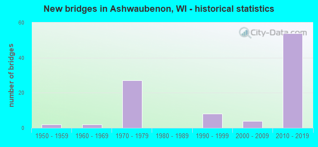
- New bridges - historical statistics
- 21950-1959
- 21960-1969
- 271970-1979
- 81990-1999
- 42000-2009
- 542010-2019

- Reconstructed bridges - Historical Statistics
- 11970-1979
- 11980-1989
- 21990-1999
- 12000-2009
- 22010-2019


- Bridge Condition - Deck
- 18.9%Very good
- 73.6%Good
- 7.5%Satisfactory

- Bridge Condition - Superstructure
- 1.9%Excellent
- 67.9%Very good
- 18.9%Good
- 9.4%Satisfactory
- 1.9%Fair

- Bridge Condition - Substructure
- 1.9%Excellent
- 56.6%Very good
- 26.4%Good
- 11.3%Satisfactory
- 1.9%Fair
- 1.9%Poor

- Bridge Condition - Channel
- 3.8%Excellent
- 76.9%Very good
- 15.4%Good
- 3.8%Poor

- Bridge Condition - Culverts
- 57.1%Good
- 42.9%Satisfactory
Find on map >> Show street view
Structure Number: B050032, Location: 0.9M E JCT CTH FF (Lat: 44.553469, Lng: -88.114200), Route carried "on" structure: State highway 29, Year Built: 1955, Year Reconstructed: 1987, Status: Open, Structure Length: 1.04m (3.41ft), Average Daily Traffic: 33,800 (year 2021), Truck Traffic: 3%, Average Future Daily Traffic: 42,890 (year 2040), Design Load: H 20, Features Intersected: LANCASTER BROOK
Minimum Vertical Clearance: 30+ m (98+ ft), Kilometerpoint: 0.000, Lanes on structure: 4, Base Highway Network: Yes, Owner: State Highway Agency, Approaching Roadway Width: 13.4m (44.0ft), Material/Design: Concrete continuous, Design/Construction: Culvert, Number Of Spans In Main Unit: 3, Length of Maximum Span: 3.0m (9.8ft)
Condition: Channel: Very good, Culverts: Good, Operating Rating: 53.9 metric tons, Method Used To Determine Operating Rating: Field evaluation and documented engineering judgment, Inventory Rating: 24.3 metric tons, Method Used To Determine Inventory Rating: Field evaluation and documented engineering judgment, Structural Evaluation: Equal to present minimum criteria, Waterway Adequacy: Equal to present desirable criteria, Approach Roadway Alignment: Equal to present desirable criteria, Designated Inspection Frequency: Every 24 months, Inspection Date: January 2021, Deck Structure Type: Concrete Cast-file-Place, Wearing Surface/Protective System: Wearing Surface: Monolithic Concrete
Find on map >> Show street view
Structure Number: B050035, Location: 0.15 MI N OF CTH YY (PILG (Lat: 44.482214, Lng: -88.056083), Route carried "on" structure: Business US 41, Year Built: 1956, Status: Open, Structure Length: 1.31m (4.30ft), Average Daily Traffic: 10,500 (year 2021), Truck Traffic: 9%, Average Future Daily Traffic: 25,900 (year 2040), Design Load: H 20, Features Intersected: DUTCHMANS CREEK, Facility Carried by Structure: USH STH 32 NB-USH
Minimum Vertical Clearance: 30+ m (98+ ft), Kilometerpoint: 0.000, Lanes on structure: 2, Owner: State Highway Agency, Approaching Roadway Width: 12.2m (40.0ft), Material/Design: Concrete continuous, Design/Construction: Culvert, Number Of Spans In Main Unit: 2, Length of Maximum Span: 6.4m (21.0ft)
Condition: Channel: Very good, Culverts: Satisfactory, Operating Rating: 53.9 metric tons, Method Used To Determine Operating Rating: Field evaluation and documented engineering judgment, Inventory Rating: 32.4 metric tons, Method Used To Determine Inventory Rating: Field evaluation and documented engineering judgment, Structural Evaluation: Equal to present minimum criteria, Waterway Adequacy: Equal to present desirable criteria, Approach Roadway Alignment: Equal to present desirable criteria, Designated Inspection Frequency: Every 24 months, Inspection Date: January 2021, Deck Structure Type: Concrete Cast-file-Place, Wearing Surface/Protective System: Wearing Surface: Monolithic Concrete
Find on map >> Show street view
Structure Number: B050105, Location: 0.2M W JCT USH 41 (Lat: 44.445114, Lng: -88.098786), Route carried "on" structure: County highway , Year Built: 1965, Status: Open, Structure Length: 1.66m (5.45ft), Average Daily Traffic: 6,699 (year 2019), Average Future Daily Traffic: 7,368 (year 2040), Design Load: HS 20, Features Intersected: ASHWAUBENON CREEK, Facility Carried by Structure: CTH EE
Minimum Vertical Clearance: 30+ m (98+ ft), Kilometerpoint: 0.000, Lanes on structure: 2, Owner: County Highway Agency, Approaching Roadway Width: 13.4m (44.0ft), Skew: 1 degrees, Material/Design: Prestressed concrete, Design/Construction: Slab, Number Of Spans In Main Unit: 1, Length of Maximum Span: 15.8m (51.8ft), Curb-To-Curb Width: 13.4m (44.0ft), Out-to-Out Width: 15.2m (49.9ft)
Condition: Deck: Satisfactory, Superstructure: Satisfactory, Substructure: Poor, Channel: Very good, Operating Rating: 52.3 metric tons, Method Used To Determine Operating Rating: Load Factor (LF), Inventory Rating: 30.8 metric tons, Method Used To Determine Inventory Rating: Load Factor (LF), Structural Evaluation: Meets minimum limits, Deck Geometry: Equal to present minimum criteria, Waterway Adequacy: Equal to present desirable criteria, Approach Roadway Alignment: Equal to present desirable criteria, Length Of Structure Improvement: 2.10m (6.89ft), Designated Inspection Frequency: Every 12 months, Inspection Date: November 2021, Bridge Improvement Cost: $262,000, Roadway Improvement Cost: $26,000, Total Project Cost: $394,000 ( Estimate for 2021), Deck Structure Type: Concrete Cast-file-Place, Wearing Surface/Protective System: Wearing Surface: Bituminous
Find on map >> Show street view
Structure Number: B050108, Location: 1.1M E JCT USH 41 (Lat: 44.477944, Lng: -88.060250), Route carried "on" structure: State highway 172, Year Built: 1975, Year Reconstructed: 2010, Status: Open, Structure Length: 11.65m (38.22ft), Average Daily Traffic: 42,350 (year 2020), Truck Traffic: 1%, Average Future Daily Traffic: 53,000 (year 2039), Design Load: HS 20, Features Intersected: USH STH 32-USH B41(ASHLA
Minimum Vertical Clearance: 30+ m (98+ ft), Kilometerpoint: 0.000, Lanes on structure: 4, Lanes under structure: 6, Base Highway Network: Yes, Owner: State Highway Agency, Approaching Roadway Width: 21.0m (68.9ft), Skew: 1 degrees, Material/Design: Steel continuous, Design/Construction: Stringer/Multi-beam, Number Of Spans In Main Unit: 6, Length of Maximum Span: 22.3m (73.2ft), Curb-To-Curb Width: 21.0m (68.9ft), Out-to-Out Width: 22.6m (74.1ft)
Condition: Deck: Good, Superstructure: Very good, Substructure: Good, Operating Rating: 63.7 metric tons, Method Used To Determine Operating Rating: Load Factor (LF), Inventory Rating: 37.3 metric tons, Method Used To Determine Inventory Rating: Load Factor (LF), Structural Evaluation: Better than present minimum criteria, Deck Geometry: Better than present minimum criteria, Underclear: Somewhat better than minimum adequacy, Approach Roadway Alignment: Equal to present desirable criteria, Designated Inspection Frequency: Every 24 months, Inspection Date: March 2020, Deck Structure Type: Concrete Cast-file-Place, Wearing Surface/Protective System: Wearing Surface: Monolithic Concrete, Membrane: Other
Find on map >> Show street view
Structure Number: B050111, Location: AT DUTCHMAN"S CREEK (Lat: 44.480717, Lng: -88.077072), Route carried "on" structure: Ramp Interstate 41, Year Built: 1974, Status: Open, Structure Length: 1.50m (4.92ft), Average Daily Traffic: 14,200 (year 2021), Truck Traffic: 11%, Average Future Daily Traffic: 100,050 (year 2040), Design Load: HS 20, Features Intersected: DUTCHMANS CREEK
Minimum Vertical Clearance: 30+ m (98+ ft), Kilometerpoint: 0.000, Lanes on structure: 2, Owner: State Highway Agency, Approaching Roadway Width: 9.4m (30.8ft), Material/Design: Concrete continuous, Design/Construction: Culvert, Number Of Spans In Main Unit: 3, Length of Maximum Span: 3.7m (12.1ft)
Condition: Channel: Very good, Culverts: Satisfactory, Operating Rating: 53.9 metric tons, Method Used To Determine Operating Rating: Field evaluation and documented engineering judgment, Inventory Rating: 32.4 metric tons, Method Used To Determine Inventory Rating: Field evaluation and documented engineering judgment, Structural Evaluation: Equal to present minimum criteria, Waterway Adequacy: Equal to present desirable criteria, Approach Roadway Alignment: Equal to present desirable criteria, Designated Inspection Frequency: Every 24 months, Inspection Date: October 2021, Deck Structure Type: Concrete Cast-file-Place, Wearing Surface/Protective System: Wearing Surface: Monolithic Concrete
Find on map >> Show street view
Structure Number: B050119, Location: 0.6M S JCT STH 32 TO S (Lat: 44.456264, Lng: -88.086772), Route carried "on" structure: Ramp Interstate 41, Year Built: 1974, Year Reconstructed: 2004, Status: Open, Structure Length: 13.45m (44.13ft), Average Daily Traffic: 6,400 (year 2020), Truck Traffic: 12%, Average Future Daily Traffic: 5,950 (year 2039), Design Load: HS 20, Features Intersected: IH 41, Facility Carried by Structure: IH RAMP ASHLAND AV
Minimum Vertical Clearance: 30+ m (98+ ft), Kilometerpoint: 0.000, Lanes on structure: 2, Lanes under structure: 5, Owner: State Highway Agency, Approaching Roadway Width: 12.2m (40.0ft), Material/Design: Steel continuous, Design/Construction: Stringer/Multi-beam, Number Of Spans In Main Unit: 4, Length of Maximum Span: 41.8m (137.1ft), Curb-To-Curb Width: 12.2m (40.0ft), Out-to-Out Width: 13.4m (44.0ft)
Condition: Deck: Good, Superstructure: Good, Substructure: Good, Operating Rating: 68.6 metric tons, Method Used To Determine Operating Rating: Load Factor (LF), Inventory Rating: 40.5 metric tons, Method Used To Determine Inventory Rating: Load Factor (LF), Structural Evaluation: Better than present minimum criteria, Deck Geometry: Superior to present desirable criteria, Underclear: Equal to present minimum criteria, Approach Roadway Alignment: Equal to present desirable criteria, Designated Inspection Frequency: Every 24 months, Critical Feature Inspection Frequency: Every 24 months, Inspection Date: April 2020, Critical Feature Inspection Date: April 2020, Deck Structure Type: Concrete Cast-file-Place, Wearing Surface/Protective System: Wearing Surface: Monolithic Concrete
Find on map >> Show street view
Structure Number: B05012, Location: 0.1M N JCT USH 41 (Lat: 44.454561, Lng: -88.087806), Route carried "on" structure: Ramp Interstate 41, Year Built: 1975, Status: Open, Structure Length: 5.59m (18.34ft), Average Daily Traffic: 8,300 (year 2021), Truck Traffic: 12%, Average Future Daily Traffic: 5,950 (year 2040), Design Load: HS 20, Features Intersected: IH I41 NB ON RAMP FROM C
Minimum Vertical Clearance: 30+ m (98+ ft), Kilometerpoint: 0.000, Lanes on structure: 1, Lanes under structure: 1, Owner: State Highway Agency, Approaching Roadway Width: 12.2m (40.0ft), Skew: 4 degrees, Material/Design: Steel continuous, Design/Construction: Stringer/Multi-beam, Number Of Spans In Main Unit: 3, Length of Maximum Span: 25.0m (82.0ft), Curb-To-Curb Width: 12.2m (40.0ft), Out-to-Out Width: 13.4m (44.0ft)
Condition: Deck: Good, Superstructure: Very good, Substructure: Good, Operating Rating: 57.0 metric tons, Method Used To Determine Operating Rating: Load Factor (LF), Inventory Rating: 34.0 metric tons, Method Used To Determine Inventory Rating: Load Factor (LF), Structural Evaluation: Better than present minimum criteria, Deck Geometry: Superior to present desirable criteria, Underclear: Meets minimum limits, Approach Roadway Alignment: Equal to present desirable criteria, Length Of Structure Improvement: 6.04m (19.82ft), Designated Inspection Frequency: Every 24 months, Inspection Date: October 2021, Bridge Improvement Cost: $750,000, Roadway Improvement Cost: $75,000, Total Project Cost: $1,125,000 ( Estimate for 2021), Deck Structure Type: Concrete Cast-file-Place, Wearing Surface/Protective System: Wearing Surface: Low Slump Concrete
Find on map >> Show street view
Structure Number: B050121, Location: 1.3M W JCT STH 57 (Lat: 44.478333, Lng: -88.060000), Route carried "on" structure: State highway 172, Year Built: 1975, Year Reconstructed: 2001, Status: Open, Structure Length: 11.69m (38.35ft), Average Daily Traffic: 42,350 (year 2020), Truck Traffic: 1%, Average Future Daily Traffic: 106,000 (year 2039), Design Load: HS 20, Features Intersected: USH STH 32-USH B41 (ASHL
Minimum Vertical Clearance: 30+ m (98+ ft), Kilometerpoint: 0.000, Lanes on structure: 4, Lanes under structure: 6, Base Highway Network: Yes, Owner: State Highway Agency, Approaching Roadway Width: 20.7m (67.9ft), Skew: 1 degrees, Material/Design: Steel continuous, Design/Construction: Stringer/Multi-beam, Number Of Spans In Main Unit: 6, Length of Maximum Span: 22.3m (73.2ft), Curb-To-Curb Width: 20.7m (67.9ft), Out-to-Out Width: 21.5m (70.5ft)
Condition: Deck: Very good, Superstructure: Very good, Substructure: Good, Operating Rating: 60.4 metric tons, Method Used To Determine Operating Rating: Load Factor (LF), Inventory Rating: 35.6 metric tons, Method Used To Determine Inventory Rating: Load Factor (LF), Structural Evaluation: Better than present minimum criteria, Deck Geometry: Superior to present desirable criteria, Underclear: Equal to present minimum criteria, Approach Roadway Alignment: Equal to present desirable criteria, Designated Inspection Frequency: Every 48 months, Inspection Date: March 2020, Deck Structure Type: Concrete Cast-file-Place, Wearing Surface/Protective System: Wearing Surface: Monolithic Concrete
Find on map >> Show street view
Structure Number: B050141, Location: 6.3M N JCT STH 29 TO E (Lat: 44.511667, Lng: -87.998333), Route carried "on" structure: US 141, Year Built: 1971, Status: Open, Structure Length: 3.25m (10.66ft), Average Daily Traffic: 18,497 (year 2019), Truck Traffic: 3%, Average Future Daily Traffic: 20,346 (year 2039), Design Load: HS 20, Features Intersected: EAST RIVER
Minimum Vertical Clearance: 30+ m (98+ ft), Kilometerpoint: 0.000, Lanes on structure: 5, Base Highway Network: Yes, Owner: City or Municipal Highway Agency, Approaching Roadway Width: 18.3m (60.0ft), Skew: 20 degrees, Material/Design: Steel, Design/Construction: Stringer/Multi-beam, Number Of Spans In Main Unit: 1, Length of Maximum Span: 31.4m (103.0ft), Curb or Sidewalk Widths: Left: 3.0m (9.8ft), Right: 3.0m (9.8ft), Curb-To-Curb Width: 18.3m (60.0ft), Out-to-Out Width: 25.0m (82.0ft)
Condition: Deck: Good, Superstructure: Good, Substructure: Satisfactory, Channel: Very good, Operating Rating: 73.0 metric tons, Method Used To Determine Operating Rating: Load Factor (LF), Inventory Rating: 43.7 metric tons, Method Used To Determine Inventory Rating: Load Factor (LF), Structural Evaluation: Equal to present minimum criteria, Deck Geometry: High priority of replacement, Waterway Adequacy: Equal to present desirable criteria, Approach Roadway Alignment: Equal to present desirable criteria, Length Of Structure Improvement: 3.69m (12.11ft), Designated Inspection Frequency: Every 24 months, Underwater Inspection Frequency: Every 60 months, Inspection Date: October 2020, Underwater Inspection Date: April 2020, Bridge Improvement Cost: $591,000, Roadway Improvement Cost: $59,000, Total Project Cost: $887,000 ( Estimate for 2021), Deck Structure Type: Concrete Cast-file-Place, Wearing Surface/Protective System: Wearing Surface: Low Slump Concrete
Find on map >> Show street view
Structure Number: B050143, Location: AT JCT USH 41-STH 172 (Lat: 44.486947, Lng: -88.084061), Route carried "on" structure: Ramp Interstate 41, Year Built: 1974, Status: Open, Structure Length: 6.14m (20.14ft), Average Daily Traffic: 15,600 (year 2020), Truck Traffic: 3%, Average Future Daily Traffic: 37,580 (year 2039), Design Load: HS 20, Features Intersected: STH 172 WB
Minimum Vertical Clearance: 30+ m (98+ ft), Kilometerpoint: 0.000, Lanes on structure: 2, Lanes under structure: 2, Owner: State Highway Agency, Approaching Roadway Width: 13.4m (44.0ft), Skew: 3 degrees, Material/Design: Steel continuous, Design/Construction: Stringer/Multi-beam, Number Of Spans In Main Unit: 3, Length of Maximum Span: 32.8m (107.6ft), Curb-To-Curb Width: 13.4m (44.0ft), Out-to-Out Width: 14.6m (47.9ft)
Condition: Deck: Good, Superstructure: Satisfactory, Substructure: Good, Operating Rating: 57.0 metric tons, Method Used To Determine Operating Rating: Load Factor (LF), Inventory Rating: 34.0 metric tons, Method Used To Determine Inventory Rating: Load Factor (LF), Structural Evaluation: Equal to present minimum criteria, Deck Geometry: Superior to present desirable criteria, Underclear: Somewhat better than minimum adequacy, Approach Roadway Alignment: Equal to present desirable criteria, Designated Inspection Frequency: Every 24 months, Inspection Date: March 2020, Deck Structure Type: Concrete Cast-file-Place, Wearing Surface/Protective System: Wearing Surface: Epoxy Overlay
Find on map >> Show street view
Structure Number: B050144, Location: AT JCT USH 41-STH 172 (Lat: 44.482356, Lng: -88.077336), Route carried "on" structure: Ramp Interstate 41, Year Built: 1974, Status: Open, Structure Length: 6.98m (22.90ft), Average Daily Traffic: 2,900 (year 2020), Truck Traffic: 3%, Average Future Daily Traffic: 37,580 (year 2039), Design Load: HS 20, Features Intersected: STH 172 EB
Minimum Vertical Clearance: 30+ m (98+ ft), Kilometerpoint: 0.000, Lanes on structure: 1, Lanes under structure: 3, Owner: State Highway Agency, Approaching Roadway Width: 9.4m (30.8ft), Skew: 4 degrees, Material/Design: Steel continuous, Design/Construction: Stringer/Multi-beam, Number Of Spans In Main Unit: 3, Length of Maximum Span: 40.2m (131.9ft), Curb-To-Curb Width: 9.4m (30.8ft), Out-to-Out Width: 10.6m (34.8ft)
Condition: Deck: Good, Superstructure: Fair, Substructure: Satisfactory, Operating Rating: 71.8 metric tons, Method Used To Determine Operating Rating: Load Factor (LF), Inventory Rating: 42.1 metric tons, Method Used To Determine Inventory Rating: Load Factor (LF), Structural Evaluation: Somewhat better than minimum adequacy, Deck Geometry: Superior to present desirable criteria, Underclear: Somewhat better than minimum adequacy, Approach Roadway Alignment: Equal to present desirable criteria, Designated Inspection Frequency: Every 24 months, Inspection Date: March 2020, Deck Structure Type: Concrete Cast-file-Place, Wearing Surface/Protective System: Wearing Surface: Epoxy Overlay
Find on map >> Show street view
Structure Number: B050147, Location: 1.1M W JCT STH 57 (Lat: 44.477397, Lng: -88.054756), Route carried "on" structure: State highway 172, Year Built: 1974, Year Reconstructed: 2009, Status: Open, Structure Length: 3.95m (12.96ft), Average Daily Traffic: 42,350 (year 2020), Truck Traffic: 1%, Average Future Daily Traffic: 106,000 (year 2039), Design Load: HS 20, Features Intersected: CTH H BROADWAY ST
Minimum Vertical Clearance: 30+ m (98+ ft), Kilometerpoint: 0.000, Lanes on structure: 4, Lanes under structure: 2, Base Highway Network: Yes, Owner: State Highway Agency, Approaching Roadway Width: 20.7m (67.9ft), Skew: 1 degrees, Material/Design: Prestressed concrete continuous, Design/Construction: Stringer/Multi-beam, Number Of Spans In Main Unit: 3, Length of Maximum Span: 21.0m (68.9ft), Curb-To-Curb Width: 20.7m (67.9ft), Out-to-Out Width: 21.5m (70.5ft)
Condition: Deck: Good, Superstructure: Satisfactory, Substructure: Satisfactory, Operating Rating: 57.0 metric tons, Method Used To Determine Operating Rating: Load Factor (LF), Inventory Rating: 29.2 metric tons, Method Used To Determine Inventory Rating: Load Factor (LF), Structural Evaluation: Equal to present minimum criteria, Deck Geometry: Superior to present desirable criteria, Underclear: Equal to present minimum criteria, Approach Roadway Alignment: Equal to present desirable criteria, Designated Inspection Frequency: Every 24 months, Inspection Date: March 2020, Deck Structure Type: Concrete Cast-file-Place, Wearing Surface/Protective System: Wearing Surface: Low Slump Concrete
Find on map >> Show street view
Structure Number: B050148, Location: 1.4M E JCT USH 41 (Lat: 44.477128, Lng: -88.055567), Route carried "on" structure: State highway 172, Year Built: 1974, Status: Open, Structure Length: 4.08m (13.39ft), Average Daily Traffic: 32,050 (year 2020), Truck Traffic: 1%, Average Future Daily Traffic: 106,000 (year 2039), Design Load: HS 20, Features Intersected: CTH H BROADWAY ST
Minimum Vertical Clearance: 30+ m (98+ ft), Kilometerpoint: 0.000, Lanes on structure: 3, Lanes under structure: 2, Base Highway Network: Yes, Owner: State Highway Agency, Approaching Roadway Width: 17.1m (56.1ft), Skew: 1 degrees, Material/Design: Prestressed concrete continuous, Design/Construction: Stringer/Multi-beam, Number Of Spans In Main Unit: 3, Length of Maximum Span: 21.0m (68.9ft), Curb-To-Curb Width: 20.7m (67.9ft), Out-to-Out Width: 21.5m (70.5ft)
Condition: Deck: Satisfactory, Superstructure: Very good, Substructure: Satisfactory, Operating Rating: 71.8 metric tons, Method Used To Determine Operating Rating: Load Factor (LF), Inventory Rating: 35.6 metric tons, Method Used To Determine Inventory Rating: Load Factor (LF), Structural Evaluation: Equal to present minimum criteria, Deck Geometry: Superior to present desirable criteria, Underclear: Better than present minimum criteria, Approach Roadway Alignment: Equal to present desirable criteria, Designated Inspection Frequency: Every 24 months, Inspection Date: March 2020, Deck Structure Type: Concrete Cast-file-Place, Wearing Surface/Protective System: Wearing Surface: Low Slump Concrete
Find on map >> Show street view
Structure Number: B050149, Location: 1.7M E JCT USH 41 (Lat: 44.476250, Lng: -88.049836), Route carried "on" structure: State highway 172, Year Built: 1975, Year Reconstructed: 2010, Status: Open, Structure Length: 98.30m (322.51ft), Average Daily Traffic: 84,700 (year 2021), Truck Traffic: 1%, Average Future Daily Traffic: 53,000 (year 2040), Design Load: HS 20, Features Intersected: STH57-RIVERSIDE DR-FOX R
Minimum Vertical Clearance: 30+ m (98+ ft), Kilometerpoint: 0.000, Lanes on structure: 6, Lanes under structure: 4, Base Highway Network: Yes, Owner: State Highway Agency, Approaching Roadway Width: 29.9m (98.1ft), Skew: 30 degrees, Navigation Control: Yes ( Vertical Clearance: 18.3m (60.0ft), Horizontal Clearance: 45.7m (149.9ft)), Material/Design: Steel continuous, Design/Construction: Stringer/Multi-beam, Number Of Spans In Main Unit: 18, Length of Maximum Span: 67.1m (220.1ft), Curb-To-Curb Width: 28.8m (94.5ft), Out-to-Out Width: 31.2m (102.4ft)
Condition: Deck: Good, Superstructure: Good, Substructure: Satisfactory, Channel: Very good, Operating Rating: 53.9 metric tons, Method Used To Determine Operating Rating: Load Factor (LF), Inventory Rating: 32.4 metric tons, Method Used To Determine Inventory Rating: Load Factor (LF), Structural Evaluation: Equal to present minimum criteria, Deck Geometry: Better than present minimum criteria, Underclear: Equal to present minimum criteria, Waterway Adequacy: Equal to present desirable criteria, Approach Roadway Alignment: Equal to present desirable criteria, Designated Inspection Frequency: Every 24 months, Underwater Inspection Frequency: Every 60 months, Other Special Inspection Frequency: Every 72 months, Inspection Date: June 2021, Underwater Inspection Date: June 2020, Other Special Inspection Date: June 2021, Deck Structure Type: Concrete Cast-file-Place, Wearing Surface/Protective System: Wearing Surface: Monolithic Concrete, Deck Protection: Epoxy Coated Reinforcing
Find on map >> Show street view
Structure Number: B050151, Location: 0.9M E JCT USH 41 (Lat: 44.478747, Lng: -88.064147), Route carried "on" structure: State highway 172, Year Built: 1973, Status: Open, Structure Length: 3.61m (11.84ft), Average Daily Traffic: 29,450 (year 2020), Truck Traffic: 1%, Average Future Daily Traffic: 95,000 (year 2039), Design Load: HS 20, Features Intersected: DUTCHMANS CREEK
Minimum Vertical Clearance: 30+ m (98+ ft), Kilometerpoint: 0.000, Lanes on structure: 3, Base Highway Network: Yes, Owner: State Highway Agency, Approaching Roadway Width: 17.1m (56.1ft), Skew: 1 degrees, Material/Design: Prestressed concrete, Design/Construction: Stringer/Multi-beam, Number Of Spans In Main Unit: 1, Length of Maximum Span: 35.4m (116.1ft), Curb-To-Curb Width: 17.1m (56.1ft), Out-to-Out Width: 18.2m (59.7ft)
Condition: Deck: Good, Superstructure: Very good, Substructure: Good, Channel: Very good, Operating Rating: 68.6 metric tons, Method Used To Determine Operating Rating: Load Factor (LF), Inventory Rating: 32.4 metric tons, Method Used To Determine Inventory Rating: Load Factor (LF), Structural Evaluation: Better than present minimum criteria, Deck Geometry: Superior to present desirable criteria, Waterway Adequacy: Equal to present desirable criteria, Approach Roadway Alignment: Equal to present desirable criteria, Designated Inspection Frequency: Every 24 months, Inspection Date: March 2020, Deck Structure Type: Concrete Cast-file-Place, Wearing Surface/Protective System: Wearing Surface: Low Slump Concrete
Find on map >> Show street view
Structure Number: B050152, Location: AT JCT STH 32-172-B41 (Lat: 44.477219, Lng: -88.066136), Route carried "on" structure: Ramp State highway , Year Built: 1973, Status: Open, Structure Length: 2.55m (8.37ft), Average Daily Traffic: 5,200 (year 2020), Truck Traffic: 1%, Average Future Daily Traffic: 10,200 (year 2039), Design Load: HS 20, Features Intersected: DUTCHMANS CREEK, Facility Carried by Structure: STH 172 EB OFF RAM
Minimum Vertical Clearance: 30+ m (98+ ft), Kilometerpoint: 0.000, Lanes on structure: 2, Owner: State Highway Agency, Approaching Roadway Width: 9.4m (30.8ft), Material/Design: Concrete, Design/Construction: Slab, Number Of Spans In Main Unit: 2, Length of Maximum Span: 12.6m (41.3ft), Curb-To-Curb Width: 10.2m (33.5ft), Out-to-Out Width: 11.4m (37.4ft)
Condition: Deck: Very good, Superstructure: Very good, Substructure: Very good, Channel: Very good, Operating Rating: 53.9 metric tons, Method Used To Determine Operating Rating: Load Factor (LF), Inventory Rating: 32.4 metric tons, Method Used To Determine Inventory Rating: Load Factor (LF), Structural Evaluation: Equal to present desirable criteria, Deck Geometry: Equal to present minimum criteria, Waterway Adequacy: Equal to present desirable criteria, Approach Roadway Alignment: Equal to present desirable criteria, Designated Inspection Frequency: Every 24 months, Inspection Date: March 2020, Deck Structure Type: Concrete Cast-file-Place, Wearing Surface/Protective System: Wearing Surface: Low Slump Concrete
Find on map >> Show street view
Structure Number: B050153, Location: 0.2M W JCT STH 32 (Lat: 44.480806, Lng: -88.062686), Route carried "on" structure: County highway , Year Built: 1973, Status: Open, Structure Length: 2.70m (8.86ft), Average Daily Traffic: 9,091 (year 2019), Average Future Daily Traffic: 10,000 (year 2039), Design Load: HS 20, Features Intersected: DUTCHMANS CREEK, Facility Carried by Structure: CTH YY / PILGRIM W
Minimum Vertical Clearance: 30+ m (98+ ft), Kilometerpoint: 0.000, Lanes on structure: 5, Owner: County Highway Agency, Approaching Roadway Width: 19.5m (64.0ft), Skew: 21 degrees, Material/Design: Prestressed concrete, Design/Construction: Stringer/Multi-beam, Number Of Spans In Main Unit: 1, Length of Maximum Span: 26.4m (86.6ft), Curb or Sidewalk Widths: Left: 2.0m (6.6ft), Right: 2.0m (6.6ft), Curb-To-Curb Width: 21.3m (69.9ft), Out-to-Out Width: 26.8m (87.9ft)
Condition: Deck: Satisfactory, Superstructure: Very good, Substructure: Good, Channel: Very good, Operating Rating: 99.6 metric tons, Method Used To Determine Operating Rating: Load Factor (LF), Inventory Rating: 42.1 metric tons, Method Used To Determine Inventory Rating: Load Factor (LF), Structural Evaluation: Better than present minimum criteria, Deck Geometry: Somewhat better than minimum adequacy, Waterway Adequacy: Equal to present desirable criteria, Approach Roadway Alignment: Equal to present desirable criteria, Designated Inspection Frequency: Every 24 months, Inspection Date: November 2020, Deck Structure Type: Concrete Cast-file-Place, Wearing Surface/Protective System: Wearing Surface: Monolithic Concrete
Find on map >> Show street view
Structure Number: B050155, Location: 0.1M W JCT USH 41 (Lat: 44.485483, Lng: -88.081983), Route carried "on" structure: State highway 172, Year Built: 1974, Status: Open, Structure Length: 0.69m (2.26ft), Average Daily Traffic: 28,400 (year 2020), Truck Traffic: 11%, Average Future Daily Traffic: 50,025 (year 2039), Design Load: HS 20, Features Intersected: BR DUTCHMANS CREEK
Minimum Vertical Clearance: 30+ m (98+ ft), Kilometerpoint: 0.000, Lanes on structure: 4, Base Highway Network: Yes, Owner: State Highway Agency, Approaching Roadway Width: 12.2m (40.0ft), Skew: 2 degrees, Material/Design: Concrete continuous, Design/Construction: Culvert, Number Of Spans In Main Unit: 2, Length of Maximum Span: 2.7m (8.9ft)
Condition: Channel: Good, Culverts: Good, Operating Rating: 53.9 metric tons, Method Used To Determine Operating Rating: Field evaluation and documented engineering judgment, Inventory Rating: 32.4 metric tons, Method Used To Determine Inventory Rating: Field evaluation and documented engineering judgment, Structural Evaluation: Better than present minimum criteria, Waterway Adequacy: Equal to present desirable criteria, Approach Roadway Alignment: Equal to present desirable criteria, Designated Inspection Frequency: Every 24 months, Inspection Date: March 2020, Deck Structure Type: Concrete Cast-file-Place, Wearing Surface/Protective System: Wearing Surface: Monolithic Concrete
Find on map >> Show street view
Structure Number: B050156, Location: 1.3M E JCT CTH GH (Lat: 44.481667, Lng: -88.083333), Route carried "on" structure: Ramp Interstate 41, Year Built: 1974, Status: Open, Structure Length: 0.74m (2.43ft), Average Daily Traffic: 2,900 (year 2020), Truck Traffic: 11%, Average Future Daily Traffic: 100,050 (year 2041), Design Load: HS 20, Features Intersected: BR DUTCHMANS CREEK, Facility Carried by Structure: IH RAMP STH 172 E-
Minimum Vertical Clearance: 30+ m (98+ ft), Kilometerpoint: 0.000, Lanes on structure: 1, Owner: State Highway Agency, Approaching Roadway Width: 9.4m (30.8ft), Skew: 3 degrees, Material/Design: Concrete continuous, Design/Construction: Culvert, Number Of Spans In Main Unit: 2, Length of Maximum Span: 2.7m (8.9ft)
Condition: Channel: Good, Culverts: Satisfactory, Operating Rating: 53.9 metric tons, Method Used To Determine Operating Rating: Field evaluation and documented engineering judgment, Inventory Rating: 32.4 metric tons, Method Used To Determine Inventory Rating: Field evaluation and documented engineering judgment, Structural Evaluation: Equal to present minimum criteria, Waterway Adequacy: Better than present minimum criteria, Approach Roadway Alignment: Equal to present desirable criteria, Designated Inspection Frequency: Every 1 months, Inspection Date: Febuary 2022, Deck Structure Type: Concrete Cast-file-Place, Wearing Surface/Protective System: Wearing Surface: Monolithic Concrete
Find on map >> Show street view
Structure Number: B050157, Location: 1.5M W JCT STH 57 (Lat: 44.479050, Lng: -88.063697), Route carried "on" structure: State highway 172, Year Built: 1973, Status: Open, Structure Length: 3.61m (11.84ft), Average Daily Traffic: 29,450 (year 2020), Truck Traffic: 1%, Average Future Daily Traffic: 95,000 (year 2039), Design Load: HS 20, Features Intersected: DUTCHMANS CREEK
Minimum Vertical Clearance: 30+ m (98+ ft), Kilometerpoint: 0.000, Lanes on structure: 3, Base Highway Network: Yes, Owner: State Highway Agency, Approaching Roadway Width: 17.1m (56.1ft), Skew: 1 degrees, Material/Design: Prestressed concrete, Design/Construction: Stringer/Multi-beam, Number Of Spans In Main Unit: 1, Length of Maximum Span: 35.4m (116.1ft), Curb-To-Curb Width: 17.1m (56.1ft), Out-to-Out Width: 18.2m (59.7ft)
Condition: Deck: Very good, Superstructure: Good, Substructure: Satisfactory, Channel: Good, Operating Rating: 68.6 metric tons, Method Used To Determine Operating Rating: Load Factor (LF), Inventory Rating: 32.4 metric tons, Method Used To Determine Inventory Rating: Load Factor (LF), Structural Evaluation: Equal to present minimum criteria, Deck Geometry: Superior to present desirable criteria, Waterway Adequacy: Equal to present desirable criteria, Approach Roadway Alignment: Equal to present desirable criteria, Designated Inspection Frequency: Every 24 months, Inspection Date: March 2020, Deck Structure Type: Concrete Cast-file-Place, Wearing Surface/Protective System: Wearing Surface: Low Slump Concrete
Find on map >> Show street view
Structure Number: B050266, Location: 1.8M S JCT STH 32 (Lat: 44.478675, Lng: -88.072597), Route carried "on" structure: County highway , Year Built: 1964, Year Reconstructed: 1982, Status: Open, Structure Length: 1.43m (4.69ft), Average Daily Traffic: 16,646 (year 2019), Average Future Daily Traffic: 18,310 (year 2040), Design Load: HS 20, Features Intersected: DUTCHMANS CREEK, Facility Carried by Structure: CTH AAA ONEIDA ST
Minimum Vertical Clearance: 30+ m (98+ ft), Kilometerpoint: 0.000, Lanes on structure: 4, Owner: County Highway Agency, Approaching Roadway Width: 16.5m (54.1ft), Skew: 20 degrees, Material/Design: Prestressed concrete, Design/Construction: Slab, Number Of Spans In Main Unit: 1, Length of Maximum Span: 13.3m (43.6ft), Curb or Sidewalk Widths: Left: 2.0m (6.6ft), Right: 2.0m (6.6ft), Curb-To-Curb Width: 21.3m (69.9ft), Out-to-Out Width: 25.0m (82.0ft)
Condition: Deck: Satisfactory, Superstructure: Satisfactory, Substructure: Fair, Channel: Very good, Operating Rating: 37.6 metric tons, Method Used To Determine Operating Rating: Load Factor (LF), Inventory Rating: 22.7 metric tons, Method Used To Determine Inventory Rating: Load Factor (LF), Structural Evaluation: Somewhat better than minimum adequacy, Deck Geometry: Superior to present desirable criteria, Waterway Adequacy: Equal to present desirable criteria, Approach Roadway Alignment: Equal to present desirable criteria, Designated Inspection Frequency: Every 24 months, Inspection Date: October 2021, Deck Structure Type: Concrete Cast-file-Place, Wearing Surface/Protective System: Wearing Surface: Low Slump Concrete
Find on map >> Show street view
Structure Number: B05033, Location: 1.0M N JCT STH 29 (Lat: 44.598211, Lng: -88.190494), Route carried "on" structure: County highway , Year Built: 2002, Status: Open, Structure Length: 1.17m (3.84ft), Average Daily Traffic: 923 (year 2019), Truck Traffic: 8%, Average Future Daily Traffic: 1,015 (year 2035), Design Load: HS 20, Features Intersected: SUAMICO RIVER, Facility Carried by Structure: CTH U
Minimum Vertical Clearance: 30+ m (98+ ft), Kilometerpoint: 0.000, Lanes on structure: 2, Owner: County Highway Agency, Approaching Roadway Width: 11.0m (36.1ft), Material/Design: Concrete, Design/Construction: Slab, Number Of Spans In Main Unit: 1, Length of Maximum Span: 11.0m (36.1ft), Curb-To-Curb Width: 10.4m (34.1ft), Out-to-Out Width: 10.9m (35.8ft)
Condition: Deck: Good, Superstructure: Good, Substructure: Very good, Channel: Very good, Operating Rating: 65.0 metric tons, Method Used To Determine Operating Rating: Load Factor (LF), Inventory Rating: 38.9 metric tons, Method Used To Determine Inventory Rating: Load Factor (LF), Structural Evaluation: Better than present minimum criteria, Deck Geometry: Equal to present minimum criteria, Waterway Adequacy: Meets minimum limits, Approach Roadway Alignment: Equal to present desirable criteria, Designated Inspection Frequency: Every 48 months, Inspection Date: October 2019, Deck Structure Type: Concrete Cast-file-Place, Wearing Surface/Protective System: Wearing Surface: Monolithic Concrete, Deck Protection: Epoxy Coated Reinforcing
Find on map >> Show street view
Structure Number: B050331, Location: 0.1M N JCT CTH HH (Lat: 44.477156, Lng: -88.068286), Route carried "on" structure: City street , Year Built: 1998, Status: Open, Structure Length: 1.55m (5.09ft), Average Daily Traffic: 13,038 (year 2019), Average Future Daily Traffic: 14,341 (year 2039), Design Load: HS 20, Features Intersected: DUTCHMANS CREEK, Facility Carried by Structure: LRD HOLMGREN WAY
Minimum Vertical Clearance: 30+ m (98+ ft), Kilometerpoint: 0.000, Lanes on structure: 2, Owner: City or Municipal Highway Agency, Approaching Roadway Width: 21.3m (69.9ft), Material/Design: Concrete, Design/Construction: Slab, Number Of Spans In Main Unit: 1, Length of Maximum Span: 15.2m (49.9ft), Curb or Sidewalk Widths: Left: 2.0m (6.6ft), Right: 2.0m (6.6ft), Curb-To-Curb Width: 19.5m (64.0ft), Out-to-Out Width: 25.0m (82.0ft)
Condition: Deck: Very good, Superstructure: Very good, Substructure: Very good, Channel: Very good, Operating Rating: 91.4 metric tons, Method Used To Determine Operating Rating: Load Factor (LF), Inventory Rating: 53.5 metric tons, Method Used To Determine Inventory Rating: Load Factor (LF), Structural Evaluation: Equal to present desirable criteria, Deck Geometry: Superior to present desirable criteria, Waterway Adequacy: Equal to present desirable criteria, Approach Roadway Alignment: Superior to present desirable criteria, Designated Inspection Frequency: Every 48 months, Inspection Date: October 2020, Deck Structure Type: Concrete Cast-file-Place, Wearing Surface/Protective System: Wearing Surface: Monolithic Concrete, Deck Protection: Epoxy Coated Reinforcing
Find on map >> Show street view
Structure Number: B050332, Location: 0.9M E JCT USH 41 (Lat: 44.479333, Lng: -88.067164), Route carried "on" structure: State highway 172, Year Built: 1998, Status: Open, Structure Length: 4.51m (14.80ft), Average Daily Traffic: 29,450 (year 2020), Truck Traffic: 1%, Average Future Daily Traffic: 55,215 (year 2039), Design Load: HS 20, Features Intersected: LRD HOLMGREN WAY
Minimum Vertical Clearance: 30+ m (98+ ft), Kilometerpoint: 0.000, Lanes on structure: 3, Lanes under structure: 4, Base Highway Network: Yes, Owner: State Highway Agency, Approaching Roadway Width: 17.1m (56.1ft), Material/Design: Concrete continuous, Design/Construction: Slab, Number Of Spans In Main Unit: 4, Length of Maximum Span: 12.7m (41.7ft), Curb-To-Curb Width: 17.1m (56.1ft), Out-to-Out Width: 18.0m (59.1ft)
Condition: Deck: Good, Superstructure: Good, Substructure: Very good, Operating Rating: 71.8 metric tons, Method Used To Determine Operating Rating: Load Factor (LF), Inventory Rating: 42.1 metric tons, Method Used To Determine Inventory Rating: Load Factor (LF), Structural Evaluation: Better than present minimum criteria, Deck Geometry: Equal to present minimum criteria, Underclear: Somewhat better than minimum adequacy, Approach Roadway Alignment: Equal to present desirable criteria, Designated Inspection Frequency: Every 48 months, Inspection Date: March 2020, Deck Structure Type: Concrete Cast-file-Place, Wearing Surface/Protective System: Wearing Surface: Monolithic Concrete, Deck Protection: Epoxy Coated Reinforcing
Find on map >> Show street view
Structure Number: B050333, Location: 1.6M W JCT STH 57 (Lat: 44.479650, Lng: -88.066342), Route carried "on" structure: State highway 172, Year Built: 1998, Status: Open, Structure Length: 4.51m (14.80ft), Average Daily Traffic: 29,450 (year 2020), Truck Traffic: 12%, Average Future Daily Traffic: 66,150 (year 2039), Design Load: HS 20, Features Intersected: LRD HOLMGREN WAY
Minimum Vertical Clearance: 30+ m (98+ ft), Kilometerpoint: 0.000, Lanes on structure: 3, Lanes under structure: 4, Base Highway Network: Yes, Owner: State Highway Agency, Approaching Roadway Width: 21.3m (69.9ft), Material/Design: Concrete continuous, Design/Construction: Slab, Number Of Spans In Main Unit: 4, Length of Maximum Span: 12.7m (41.7ft), Curb-To-Curb Width: 21.2m (69.6ft), Out-to-Out Width: 22.1m (72.5ft)
Condition: Deck: Good, Superstructure: Good, Substructure: Very good, Operating Rating: 70.2 metric tons, Method Used To Determine Operating Rating: Load Factor (LF), Inventory Rating: 42.1 metric tons, Method Used To Determine Inventory Rating: Load Factor (LF), Structural Evaluation: Better than present minimum criteria, Deck Geometry: Superior to present desirable criteria, Underclear: Somewhat better than minimum adequacy, Approach Roadway Alignment: Equal to present desirable criteria, Designated Inspection Frequency: Every 48 months, Inspection Date: March 2020, Deck Structure Type: Concrete Cast-file-Place, Wearing Surface/Protective System: Wearing Surface: Monolithic Concrete, Deck Protection: Epoxy Coated Reinforcing
Find on map >> Show street view
Structure Number: B050334, Location: AT JCT STH 32-172-B41 (Lat: 44.479206, Lng: -88.067244), Route carried "on" structure: State highway 79, Year Built: 1998, Status: Open, Structure Length: 2.44m (8.01ft), Average Daily Traffic: 5,800 (year 2020), Average Future Daily Traffic: 8,501 (year 2039), Design Load: HS 20, Features Intersected: LRD HOLMGREN WAY, Facility Carried by Structure: STH CONNECTOR STH
Minimum Vertical Clearance: 30+ m (98+ ft), Kilometerpoint: 0.000, Lanes on structure: 1, Lanes under structure: 4, Base Highway Network: Yes, Owner: State Highway Agency, Approaching Roadway Width: 9.4m (30.8ft), Skew: 1 degrees, Material/Design: Concrete, Design/Construction: Slab, Number Of Spans In Main Unit: 4, Length of Maximum Span: 13.0m (42.7ft), Curb-To-Curb Width: 9.4m (30.8ft), Out-to-Out Width: 10.1m (33.1ft)
Condition: Deck: Good, Superstructure: Good, Substructure: Very good, Operating Rating: 63.7 metric tons, Method Used To Determine Operating Rating: Load Factor (LF), Inventory Rating: 37.3 metric tons, Method Used To Determine Inventory Rating: Load Factor (LF), Structural Evaluation: Better than present minimum criteria, Deck Geometry: High priority of corrective action, Underclear: Somewhat better than minimum adequacy, Approach Roadway Alignment: Equal to present desirable criteria, Length Of Structure Improvement: 2.90m (9.51ft), Designated Inspection Frequency: Every 48 months, Inspection Date: March 2020, Bridge Improvement Cost: $359,000, Roadway Improvement Cost: $35,000, Total Project Cost: $538,000 ( Estimate for 2021), Deck Structure Type: Concrete Cast-file-Place, Wearing Surface/Protective System: Wearing Surface: Monolithic Concrete, Deck Protection: Epoxy Coated Reinforcing
Find on map >> Show street view
Structure Number: B050338, Location: 0.1M N JCT CTH"AAA" (Lat: 44.476311, Lng: -88.109500), Route carried "on" structure: County highway , Year Built: 1999, Status: Open, Structure Length: 1.01m (3.31ft), Average Daily Traffic: 12,687 (year 2019), Average Future Daily Traffic: 13,955 (year 2040), Design Load: HS 20, Features Intersected: DUTCHMAN CREEK, Facility Carried by Structure: CTH EB
Minimum Vertical Clearance: 30+ m (98+ ft), Kilometerpoint: 0.000, Lanes on structure: 2, Owner: County Highway Agency, Approaching Roadway Width: 7.3m (24.0ft), Skew: 1 degrees, Material/Design: Concrete, Design/Construction: Culvert, Number Of Spans In Main Unit: 3, Length of Maximum Span: 3.0m (9.8ft)
Condition: Channel: Poor, Culverts: Good, Operating Rating: 53.9 metric tons, Method Used To Determine Operating Rating: Field evaluation and documented engineering judgment, Inventory Rating: 32.4 metric tons, Method Used To Determine Inventory Rating: Field evaluation and documented engineering judgment, Structural Evaluation: Better than present minimum criteria, Waterway Adequacy: Equal to present desirable criteria, Approach Roadway Alignment: Equal to present desirable criteria, Designated Inspection Frequency: Every 24 months, Inspection Date: October 2021, Wearing Surface/Protective System: Wearing Surface: Monolithic Concrete
Find on map >> Show street view
Structure Number: B050367, Location: 0.1M S JCT CORMIER (Lat: 44.482711, Lng: -88.050433), Route carried "on" structure: County highway , Year Built: 2003, Status: Open, Structure Length: 2.07m (6.79ft), Average Daily Traffic: 4,161 (year 2019), Average Future Daily Traffic: 4,577 (year 2040), Design Load: HS 20, Features Intersected: DUTCHMANS CREEK, Facility Carried by Structure: CTH H BROADWAY S
Minimum Vertical Clearance: 30+ m (98+ ft), Kilometerpoint: 0.000, Lanes on structure: 2, Owner: County Highway Agency, Approaching Roadway Width: 18.3m (60.0ft), Skew: 20 degrees, Material/Design: Prestressed concrete, Design/Construction: Stringer/Multi-beam, Number Of Spans In Main Unit: 1, Length of Maximum Span: 18.7m (61.4ft), Curb or Sidewalk Widths: Left: 0.0m, Right: 2.0m (6.6ft), Curb-To-Curb Width: 12.2m (40.0ft), Out-to-Out Width: 15.2m (49.9ft)
Condition: Deck: Good, Superstructure: Very good, Substructure: Good, Channel: Very good, Operating Rating: 80.0 metric tons, Method Used To Determine Operating Rating: Load Factor (LF), Inventory Rating: 40.5 metric tons, Method Used To Determine Inventory Rating: Load Factor (LF), Structural Evaluation: Better than present minimum criteria, Deck Geometry: Equal to present minimum criteria, Waterway Adequacy: Equal to present desirable criteria, Approach Roadway Alignment: Equal to present desirable criteria, Designated Inspection Frequency: Every 24 months, Inspection Date: October 2021, Deck Structure Type: Concrete Cast-file-Place, Wearing Surface/Protective System: Wearing Surface: Monolithic Concrete, Deck Protection: Epoxy Coated Reinforcing
Find on map >> Show street view
Structure Number: B050381, Location: AT FOX RIVER (Lat: 44.327331, Lng: -88.167653), Route carried "on" structure: State highway 96, Year Built: 2015, Status: Open, Structure Length: 55.37m (181.66ft), Average Daily Traffic: 9,900 (year 2021), Average Future Daily Traffic: 13,000 (year 2040), Design Load: HL 93, Features Intersected: CTH ZZ
Minimum Vertical Clearance: 30+ m (98+ ft), Kilometerpoint: 0.000, Lanes on structure: 2, Lanes under structure: 2, Owner: State Highway Agency, Approaching Roadway Width: 12.2m (40.0ft), Navigation Control: Yes ( Vertical Clearance: 9.1m (29.9ft), Horizontal Clearance: 39.6m (129.9ft)), Material/Design: Prestressed concrete, Design/Construction: Stringer/Multi-beam, Number Of Spans In Main Unit: 14, Length of Maximum Span: 47.2m (154.9ft), Curb or Sidewalk Widths: Left: 2.0m (6.6ft), Right: 2.0m (6.6ft), Curb-To-Curb Width: 12.2m (40.0ft), Out-to-Out Width: 16.6m (54.5ft)
Condition: Deck: Good, Superstructure: Very good, Substructure: Good, Channel: Good, Operating Rating: 43.4 metric tons, Method Used To Determine Operating Rating: Load and Resistance Factor Rating (LRFR) rating reported by rating factor(RF) method using HL-93 loadings, Inventory Rating: 33.4 metric tons, Method Used To Determine Inventory Rating: Load and Resistance Factor Rating (LRFR) rating reported by rating factor(RF) method using HL-93 loadings, Structural Evaluation: Better than present minimum criteria, Deck Geometry: Somewhat better than minimum adequacy, Underclear: Superior to present desirable criteria, Waterway Adequacy: Equal to present desirable criteria, Approach Roadway Alignment: Equal to present desirable criteria, Designated Inspection Frequency: Every 48 months, Underwater Inspection Frequency: Every 60 months, Inspection Date: August 2021, Underwater Inspection Date: March 2021, Deck Structure Type: Concrete Cast-file-Place, Wearing Surface/Protective System: Wearing Surface: Epoxy Overlay, Deck Protection: Epoxy Coated Reinforcing
Find on map >> Show street view
Structure Number: B050386, Location: 0.6M E JCT IH 41 (Lat: 44.480625, Lng: -88.071494), Route carried "on" structure: State highway 172, Year Built: 2010, Status: Open, Structure Length: 5.38m (17.65ft), Average Daily Traffic: 29,450 (year 2020), Average Future Daily Traffic: 47,500 (year 2039), Design Load: HS 25 or greater, Features Intersected: CTH AAA ONEIDA ST
Minimum Vertical Clearance: 30+ m (98+ ft), Kilometerpoint: 0.000, Lanes on structure: 4, Lanes under structure: 4, Base Highway Network: Yes, Owner: State Highway Agency, Approaching Roadway Width: 20.7m (67.9ft), Material/Design: Concrete continuous, Design/Construction: Slab, Number Of Spans In Main Unit: 4, Length of Maximum Span: 17.4m (57.1ft), Curb-To-Curb Width: 22.8m (74.8ft), Out-to-Out Width: 23.7m (77.8ft)
Condition: Deck: Good, Superstructure: Good, Substructure: Good, Operating Rating: 86.5 metric tons, Method Used To Determine Operating Rating: Load Factor (LF), Inventory Rating: 50.2 metric tons, Method Used To Determine Inventory Rating: Load Factor (LF), Structural Evaluation: Better than present minimum criteria, Deck Geometry: Superior to present desirable criteria, Underclear: Meets minimum limits, Approach Roadway Alignment: Equal to present desirable criteria, Designated Inspection Frequency: Every 48 months, Inspection Date: March 2020, Deck Structure Type: Concrete Cast-file-Place, Wearing Surface/Protective System: Wearing Surface: Monolithic Concrete, Deck Protection: Epoxy Coated Reinforcing
Find on map >> Show street view
Structure Number: B050387, Location: AT ONEIDA STREET (Lat: 44.480903, Lng: -88.071050), Route carried "on" structure: State highway 172, Year Built: 2009, Status: Open, Structure Length: 5.38m (17.65ft), Average Daily Traffic: 29,450 (year 2020), Truck Traffic: 12%, Average Future Daily Traffic: 47,500 (year 2039), Design Load: HS 25 or greater, Features Intersected: LRD ONEIDA ST
Minimum Vertical Clearance: 30+ m (98+ ft), Kilometerpoint: 0.000, Lanes on structure: 3, Lanes under structure: 4, Base Highway Network: Yes, Owner: State Highway Agency, Approaching Roadway Width: 17.1m (56.1ft), Material/Design: Concrete continuous, Design/Construction: Slab, Number Of Spans In Main Unit: 4, Length of Maximum Span: 17.4m (57.1ft), Curb-To-Curb Width: 17.1m (56.1ft), Out-to-Out Width: 18.0m (59.1ft)
Condition: Deck: Good, Superstructure: Good, Substructure: Very good, Operating Rating: 82.0 metric tons, Method Used To Determine Operating Rating: Load Factor (LF), Inventory Rating: 48.6 metric tons, Method Used To Determine Inventory Rating: Load Factor (LF), Structural Evaluation: Better than present minimum criteria, Deck Geometry: Superior to present desirable criteria, Underclear: Meets minimum limits, Approach Roadway Alignment: Equal to present desirable criteria, Designated Inspection Frequency: Every 48 months, Inspection Date: March 2020, Deck Structure Type: Concrete Cast-file-Place, Wearing Surface/Protective System: Wearing Surface: Monolithic Concrete, Deck Protection: Epoxy Coated Reinforcing
Find on map >> Show street view
Structure Number: B050388, Location: 0.3M E JCT USH 41 (Lat: 44.457839, Lng: -88.079039), Route carried "on" structure: City street , Year Built: 2010, Status: Open, Structure Length: 2.53m (8.30ft), Average Daily Traffic: 5,939 (year 2019), Average Future Daily Traffic: 6,532 (year 2039), Design Load: HL 93, Features Intersected: ASHWAUBENON CREEK, Facility Carried by Structure: LRD GLORY RD
Minimum Vertical Clearance: 30+ m (98+ ft), Kilometerpoint: 0.000, Lanes on structure: 2, Owner: City or Municipal Highway Agency, Approaching Roadway Width: 11.0m (36.1ft), Skew: 2 degrees, Material/Design: Concrete, Design/Construction: Box Beam or Girders - Multiple, Number Of Spans In Main Unit: 1, Length of Maximum Span: 24.4m (80.1ft), Curb-To-Curb Width: 10.4m (34.1ft), Out-to-Out Width: 12.3m (40.4ft)
Condition: Deck: Very good, Superstructure: Excellent, Substructure: Excellent, Channel: Excellent, Operating Rating: 51.8 metric tons, Method Used To Determine Operating Rating: Load and Resistance Factor Rating (LRFR) rating reported by rating factor(RF) method using HL-93 loadings, Inventory Rating: 40.2 metric tons, Method Used To Determine Inventory Rating: Load and Resistance Factor Rating (LRFR) rating reported by rating factor(RF) method using HL-93 loadings, Structural Evaluation: Superior to present desirable criteria, Deck Geometry: Meets minimum limits, Waterway Adequacy: Superior to present desirable criteria, Approach Roadway Alignment: Equal to present desirable criteria, Designated Inspection Frequency: Every 48 months, Inspection Date: October 2020, Wearing Surface/Protective System: Wearing Surface: Monolithic Concrete, Deck Protection: Epoxy Coated Reinforcing
Find on map >> Show street view
Structure Number: B050389, Location: 1.3M N JCT STH 32 (Lat: 44.464214, Lng: -88.066625), Route carried "on" structure: County highway , Year Built: 2011, Status: Open, Structure Length: 2.80m (9.19ft), Average Daily Traffic: 3,349 (year 2019), Truck Traffic: 4%, Average Future Daily Traffic: 3,683 (year 2035), Design Load: HL 93, Features Intersected: ASHWAUBENON CR, Facility Carried by Structure: CTH H - BROADWAY S
Minimum Vertical Clearance: 30+ m (98+ ft), Kilometerpoint: 0.000, Lanes on structure: 2, Owner: County Highway Agency, Approaching Roadway Width: 13.4m (44.0ft), Material/Design: Prestressed concrete, Design/Construction: Stringer/Multi-beam, Number Of Spans In Main Unit: 1, Length of Maximum Span: 26.8m (87.9ft), Curb or Sidewalk Widths: Left: 0.0m, Right: 2.0m (6.6ft), Curb-To-Curb Width: 13.4m (44.0ft), Out-to-Out Width: 16.1m (52.8ft)
Condition: Deck: Very good, Superstructure: Very good, Substructure: Very good, Channel: Very good, Operating Rating: 56.1 metric tons, Method Used To Determine Operating Rating: Load and Resistance Factor Rating (LRFR) rating reported by rating factor(RF) method using HL-93 loadings, Inventory Rating: 36.9 metric tons, Method Used To Determine Inventory Rating: Load and Resistance Factor Rating (LRFR) rating reported by rating factor(RF) method using HL-93 loadings, Structural Evaluation: Equal to present desirable criteria, Deck Geometry: Better than present minimum criteria, Waterway Adequacy: Equal to present desirable criteria, Approach Roadway Alignment: Equal to present desirable criteria, Designated Inspection Frequency: Every 48 months, Inspection Date: October 2019, Deck Structure Type: Concrete Cast-file-Place, Wearing Surface/Protective System: Wearing Surface: Monolithic Concrete, Deck Protection: Epoxy Coated Reinforcing
Find on map >> Show street view
Structure Number: B050408, Location: 1.0 MI S OF STH 172 (Lat: 44.466019, Lng: -88.069425), Route carried "on" structure: State highway 32, Year Built: 2017, Status: Open, Structure Length: 3.01m (9.88ft), Average Daily Traffic: 9,350 (year 2021), Average Future Daily Traffic: 23,600 (year 2040), Design Load: HL 93, Features Intersected: ASHWAUBENON CREEK
Minimum Vertical Clearance: 30+ m (98+ ft), Kilometerpoint: 0.000, Lanes on structure: 2, Base Highway Network: Yes, Owner: State Highway Agency, Approaching Roadway Width: 12.2m (40.0ft), Material/Design: Prestressed concrete, Design/Construction: Stringer/Multi-beam, Number Of Spans In Main Unit: 1, Length of Maximum Span: 29.0m (95.1ft), Curb-To-Curb Width: 12.2m (40.0ft), Out-to-Out Width: 13.1m (43.0ft)
Condition: Deck: Very good, Superstructure: Very good, Substructure: Very good, Channel: Very good, Operating Rating: 58.6 metric tons, Method Used To Determine Operating Rating: Load and Resistance Factor Rating (LRFR) rating reported by rating factor(RF) method using HL-93 loadings, Inventory Rating: 45.0 metric tons, Method Used To Determine Inventory Rating: Load and Resistance Factor Rating (LRFR) rating reported by rating factor(RF) method using HL-93 loadings, Structural Evaluation: Equal to present desirable criteria, Deck Geometry: Better than present minimum criteria, Waterway Adequacy: Equal to present desirable criteria, Approach Roadway Alignment: Equal to present desirable criteria, Designated Inspection Frequency: Every 48 months, Inspection Date: January 2021, Deck Structure Type: Concrete Cast-file-Place, Wearing Surface/Protective System: Wearing Surface: Epoxy Overlay, Deck Protection: Epoxy Coated Reinforcing
Find on map >> Show street view
Structure Number: B050409, Location: 1.0 MI S OF STH 172 (Lat: 44.465597, Lng: -88.069297), Route carried "on" structure: State highway 32, Year Built: 2017, Status: Open, Structure Length: 3.01m (9.88ft), Average Daily Traffic: 9,350 (year 2021), Average Future Daily Traffic: 23,600 (year 2040), Design Load: HL 93, Features Intersected: ASHWAUBENON CREEK
Minimum Vertical Clearance: 30+ m (98+ ft), Kilometerpoint: 0.000, Lanes on structure: 2, Base Highway Network: Yes, Owner: State Highway Agency, Approaching Roadway Width: 12.2m (40.0ft), Material/Design: Prestressed concrete, Design/Construction: Stringer/Multi-beam, Number Of Spans In Main Unit: 1, Length of Maximum Span: 29.0m (95.1ft), Curb-To-Curb Width: 12.2m (40.0ft), Out-to-Out Width: 13.1m (43.0ft)
Condition: Deck: Very good, Superstructure: Very good, Substructure: Very good, Channel: Very good, Operating Rating: 58.6 metric tons, Method Used To Determine Operating Rating: Load and Resistance Factor Rating (LRFR) rating reported by rating factor(RF) method using HL-93 loadings, Inventory Rating: 45.0 metric tons, Method Used To Determine Inventory Rating: Load and Resistance Factor Rating (LRFR) rating reported by rating factor(RF) method using HL-93 loadings, Structural Evaluation: Equal to present desirable criteria, Deck Geometry: Better than present minimum criteria, Waterway Adequacy: Equal to present desirable criteria, Approach Roadway Alignment: Equal to present desirable criteria, Designated Inspection Frequency: Every 48 months, Inspection Date: January 2021, Deck Structure Type: Concrete Cast-file-Place, Wearing Surface/Protective System: Wearing Surface: Epoxy Overlay, Deck Protection: Epoxy Coated Reinforcing
Find on map >> Show street view
Structure Number: B050601, Location: AT ASHWAUBENON CREEK (Lat: 44.429814, Lng: -88.111047), Route carried "on" structure: Ramp Interstate 41, Year Built: 2011, Status: Open, Structure Length: 2.95m (9.68ft), Average Daily Traffic: 3,700 (year 2019), Average Future Daily Traffic: 3,800 (year 2040), Design Load: HL 93, Features Intersected: ASHWAUBENON CREEK
Minimum Vertical Clearance: 30+ m (98+ ft), Kilometerpoint: 0.000, Lanes on structure: 2, Owner: State Highway Agency, Approaching Roadway Width: 8.5m (27.9ft), Skew: 1 degrees, Material/Design: Prestressed concrete, Design/Construction: Stringer/Multi-beam, Number Of Spans In Main Unit: 1, Length of Maximum Span: 28.3m (92.8ft), Curb-To-Curb Width: 8.5m (27.9ft), Out-to-Out Width: 9.3m (30.5ft)
Condition: Deck: Very good, Superstructure: Very good, Substructure: Very good, Channel: Very good, Operating Rating: 52.5 metric tons, Method Used To Determine Operating Rating: Load and Resistance Factor Rating (LRFR) rating reported by rating factor(RF) method using HL-93 loadings, Inventory Rating: 40.5 metric tons, Method Used To Determine Inventory Rating: Load and Resistance Factor Rating (LRFR) rating reported by rating factor(RF) method using HL-93 loadings, Structural Evaluation: Equal to present desirable criteria, Deck Geometry: High priority of corrective action, Waterway Adequacy: Equal to present desirable criteria, Approach Roadway Alignment: Equal to present desirable criteria, Length Of Structure Improvement: 3.38m (11.09ft), Designated Inspection Frequency: Every 48 months, Inspection Date: October 2021, Bridge Improvement Cost: $422,000, Roadway Improvement Cost: $42,000, Total Project Cost: $634,000 ( Estimate for 2021), Deck Structure Type: Concrete Cast-file-Place, Wearing Surface/Protective System: Wearing Surface: Monolithic Concrete, Deck Protection: Epoxy Coated Reinforcing
Find on map >> Show street view
Structure Number: B050602, Location: 0.2M N JCT STH 172 TO E (Lat: 44.481389, Lng: -88.080278), Route carried "on" structure: Interstate 41, Year Built: 2011, Status: Open, Structure Length: 1.25m (4.10ft), Average Daily Traffic: 63,900 (year 2019), Average Future Daily Traffic: 82,100 (year 2040), Design Load: HS 20, Features Intersected: DUTCHMAN CR
Minimum Vertical Clearance: 30+ m (98+ ft), Kilometerpoint: 0.000, Lanes on structure: 9, Base Highway Network: Yes, Owner: State Highway Agency, Approaching Roadway Width: 33.5m (109.9ft), Skew: 1 degrees, Material/Design: Concrete continuous, Design/Construction: Culvert, Number Of Spans In Main Unit: 3, Length of Maximum Span: 3.7m (12.1ft), Curb-To-Curb Width: 59.3m (194.6ft), Out-to-Out Width: 81.1m (266.1ft)
Condition: Channel: Very good, Culverts: Good, Operating Rating: 53.9 metric tons, Method Used To Determine Operating Rating: Field evaluation and documented engineering judgment, Inventory Rating: 32.4 metric tons, Method Used To Determine Inventory Rating: Field evaluation and documented engineering judgment, Structural Evaluation: Better than present minimum criteria, Deck Geometry: Superior to present desirable criteria, Waterway Adequacy: Equal to present desirable criteria, Approach Roadway Alignment: Equal to present desirable criteria, Designated Inspection Frequency: Every 24 months, Inspection Date: October 2021, Deck Structure Type: Concrete Cast-file-Place, Wearing Surface/Protective System: Wearing Surface: Bituminous
Find on map >> Show street view
Structure Number: B050608, Location: 2.3M S JCT STH 172 (Lat: 44.453008, Lng: -88.089853), Route carried "on" structure: Interstate 41, Year Built: 2013, Status: Open, Structure Length: 4.54m (14.90ft), Average Daily Traffic: 34,100 (year 2021), Truck Traffic: 9%, Average Future Daily Traffic: 45,000 (year 2040), Design Load: HL 93, Features Intersected: CTH G
Minimum Vertical Clearance: 30+ m (98+ ft), Kilometerpoint: 0.000, Lanes on structure: 3, Lanes under structure: 4, Base Highway Network: Yes, Owner: State Highway Agency, Approaching Roadway Width: 19.8m (65.0ft), Material/Design: Prestressed concrete continuous, Design/Construction: Stringer/Multi-beam, Number Of Spans In Main Unit: 2, Length of Maximum Span: 25.3m (83.0ft), Curb-To-Curb Width: 19.7m (64.6ft), Out-to-Out Width: 20.5m (67.3ft)
Condition: Deck: Good, Superstructure: Very good, Substructure: Very good, Operating Rating: 43.7 metric tons, Method Used To Determine Operating Rating: Load and Resistance Factor Rating (LRFR) rating reported by rating factor(RF) method using HL-93 loadings, Inventory Rating: 33.7 metric tons, Method Used To Determine Inventory Rating: Load and Resistance Factor Rating (LRFR) rating reported by rating factor(RF) method using HL-93 loadings, Structural Evaluation: Equal to present desirable criteria, Deck Geometry: Superior to present desirable criteria, Underclear: Better than present minimum criteria, Approach Roadway Alignment: Equal to present desirable criteria, Designated Inspection Frequency: Every 48 months, Inspection Date: October 2021, Deck Structure Type: Concrete Cast-file-Place, Wearing Surface/Protective System: Wearing Surface: Epoxy Overlay, Deck Protection: Epoxy Coated Reinforcing
Find on map >> Show street view
Structure Number: B050609, Location: 2.3M S JCT STH 172 (Lat: 44.452472, Lng: -88.089694), Route carried "on" structure: Interstate 41, Year Built: 2013, Status: Open, Structure Length: 4.54m (14.90ft), Average Daily Traffic: 34,100 (year 2021), Truck Traffic: 9%, Average Future Daily Traffic: 83,200 (year 2040), Design Load: HL 93, Features Intersected: CTH G
Minimum Vertical Clearance: 30+ m (98+ ft), Kilometerpoint: 0.000, Lanes on structure: 3, Lanes under structure: 4, Base Highway Network: Yes, Owner: State Highway Agency, Approaching Roadway Width: 19.5m (64.0ft), Material/Design: Prestressed concrete continuous, Design/Construction: Stringer/Multi-beam, Number Of Spans In Main Unit: 2, Length of Maximum Span: 25.3m (83.0ft), Curb-To-Curb Width: 20.1m (65.9ft), Out-to-Out Width: 21.0m (68.9ft)
Condition: Deck: Good, Superstructure: Very good, Substructure: Very good, Operating Rating: 43.1 metric tons, Method Used To Determine Operating Rating: Load and Resistance Factor Rating (LRFR) rating reported by rating factor(RF) method using HL-93 loadings, Inventory Rating: 33.0 metric tons, Method Used To Determine Inventory Rating: Load and Resistance Factor Rating (LRFR) rating reported by rating factor(RF) method using HL-93 loadings, Structural Evaluation: Equal to present desirable criteria, Deck Geometry: Superior to present desirable criteria, Underclear: Better than present minimum criteria, Approach Roadway Alignment: Equal to present desirable criteria, Designated Inspection Frequency: Every 48 months, Inspection Date: October 2021, Deck Structure Type: Concrete Cast-file-Place, Wearing Surface/Protective System: Wearing Surface: Epoxy Overlay, Deck Protection: Epoxy Coated Reinforcing
Find on map >> Show street view
Structure Number: B050611, Location: HANSON ROAD OVER IH 41 (Lat: 44.477800, Lng: -88.079333), Route carried "on" structure: City street , Year Built: 2014, Status: Open, Structure Length: 11.45m (37.57ft), Average Daily Traffic: 7,700 (year 2021), Average Future Daily Traffic: 16,200 (year 2040), Design Load: HL 93, Features Intersected: IH 41, Facility Carried by Structure: LRD HANSEN ROAD
Minimum Vertical Clearance: 30+ m (98+ ft), Kilometerpoint: 0.000, Lanes on structure: 2, Lanes under structure: 13, Owner: State Highway Agency, Approaching Roadway Width: 12.2m (40.0ft), Skew: 3 degrees, Material/Design: Prestressed concrete, Design/Construction: Stringer/Multi-beam, Number Of Spans In Main Unit: 4, Length of Maximum Span: 32.7m (107.3ft), Curb or Sidewalk Widths: Left: 2.0m (6.6ft), Right: 2.0m (6.6ft), Curb-To-Curb Width: 13.4m (44.0ft), Out-to-Out Width: 17.7m (58.1ft)
Condition: Deck: Good, Superstructure: Very good, Substructure: Good, Operating Rating: 48.3 metric tons, Method Used To Determine Operating Rating: Load and Resistance Factor Rating (LRFR) rating reported by rating factor(RF) method using HL-93 loadings, Inventory Rating: 33.4 metric tons, Method Used To Determine Inventory Rating: Load and Resistance Factor Rating (LRFR) rating reported by rating factor(RF) method using HL-93 loadings, Structural Evaluation: Better than present minimum criteria, Deck Geometry: Equal to present minimum criteria, Underclear: Equal to present minimum criteria, Approach Roadway Alignment: Equal to present desirable criteria, Designated Inspection Frequency: Every 48 months, Inspection Date: October 2021, Deck Structure Type: Concrete Cast-file-Place, Wearing Surface/Protective System: Wearing Surface: Monolithic Concrete, Deck Protection: Epoxy Coated Reinforcing