Property valuation of Weber Avenue, Akron, OH: 540, 540 (tax assessments)
Other nearby streets: E Edgerton Road  Edgerton Road (1)
Edgerton Road (2)
Pasadena Avenue
W Edgerton Road
Edgerton Road (1)
Edgerton Road (2)
Pasadena Avenue
W Edgerton Road
Edgerton Road (1)
Edgerton Road (2)
Pasadena Avenue
W Edgerton Road
Listed properties vs overall distribution of properties in Akron, OH:
Advertisements
Weber Avenue
Akron, OH 44303
Find on map >>
Owner: PAUL E JAEGER
Land value: $380
Total value for property: $380
Class: Residential
Land use: Residential, Vacant Land, Lot
Land area: 1,454 square feet
Land frontage: 14 feet
Land depth: 104 feet
Land depth table: 150 feet
Land depth factor: 0.82
Square footage: 1,456 square feet
Reason: Reappraisal
Assessments for tax year: 2009
Sale date: 11/25/2003
Price: $100
Old owner name: DONALD DUWAYNE SCHUBERT & DORIS J SCHUBERT
New owner name: PAUL E JAEGER & NANCY S JAEGER
Validity: Valid
Source: Conveyance
Weber Avenue
Akron, OH
Find on map >>
Owner: LOUISE ZINTEL
Land value: $370
Total value for property: $370
Class: Residential
Land use: Residential, Vacant Land, Lot
Land area: 248 square feet
Land frontage: 10 feet
Land depth: 25 feet
Land depth table: 150 feet
Land depth factor: 0.40
Square footage: 250 square feet
Reason: Reappraisal
Assessments for tax year: 2009
Weber Avenue
Akron, OH
Find on map >>
Owner: ANTHONY R URDIALES
Land value: $3,560
Total value for property: $3,560
Class: Residential
Land use: Residential, Vacant Land, Lot
Land area: 2,500 square feet
Land frontage: 50 feet
Land depth: 50 feet
Land depth table: 150 feet
Land depth factor: 0.57
Square footage: 2,500 square feet
Reason: Reappraisal
Assessments for tax year: 2009
Weber Avenue
Akron, OH
Find on map >>
Owner: WALTER MARY KAY CO TRUSTEE
Land value: $22,970
Total value for property: $22,970
Class: Residential
Land use: Residential, Vacant Land, Lot
Land area: 8,746 square feet
Land frontage: 53 feet
Land depth: 165 feet
Land depth table: 150 feet
Land depth factor: 1.05
Square footage: 8,745 square feet
Reason: Reappraisal
Assessments for tax year: 2009
Sale date: 09/17/1997
Old owner name: MARY K WALTER
New owner name: MARY KAY WALTER & LEO G WALTER JR
Weber Avenue
Akron, OH 44303
Find on map >>
Owner: RONALD L HARDY
Land value: $24,430
Total value for property: $24,430
Class: Residential
Land use: Residential, Vacant Land, Lot
Land area: 9,661 square feet
Land frontage: 70 feet
Land depth: 138 feet
Land depth table: 150 feet
Land depth factor: 0.96
Square footage: 9,660 square feet
Reason: Reappraisal
Assessments for tax year: 2009
Weber Avenue
Akron, OH 44303
Find on map >>
Owner: DEBORAH L SANDERS
Land value: $750
Total value for property: $750
Class: Residential
Land use: Residential, Vacant Land, Lot
Land area: 418 square feet
Land frontage: 60 feet
Land depth: 7 feet
Land depth table: 150 feet
Land depth factor: 0.16
Square footage: 420 square feet
Reason: Reappraisal
Assessments for tax year: 2009
Weber Avenue
Akron, OH
Find on map >>
Owner: MURIEL NARZISI
Land value: $2,840
Total value for property: $2,840
Class: Residential
Land use: Residential, Vacant Land, Lot
Land area: 1,498 square feet
Land frontage: 30 feet
Land depth: 50 feet
Land depth table: 150 feet
Land depth factor: 0.57
Square footage: 1,500 square feet
Reason: Reappraisal
Assessments for tax year: 2009
540 Weber Avenue
Akron, OH 44303
Find on map >>
Owner: CHARLES D GARDNER
Land value: $7,490
Total value for property: $7,490
Class: Residential
Land use: Residential, Vacant Land, Lot
Land area: 3,781 square feet
Land frontage: 36 feet
Land depth: 105 feet
Land depth table: 150 feet
Land depth factor: 0.83
Square footage: 3,780 square feet
Reason: Reappraisal
Assessments for tax year: 2009
540 Weber Avenue
Akron, OH 44303
Find on map >>
Owner: CHARLES D GARDNER
Building value: $38,680
Land value: $20,000
Total value for property: $58,680
Class: Residential
Land use: Single Family Dwelling, Platted Lot
Land area: 6,673 square feet
Land frontage: 48 feet
Land depth: 139 feet
Land depth table: 150 feet
Land depth factor: 0.96
Square footage: 6,672 square feet
Reason: Building destroyed
Assessments for tax year: 2009
Sales:
-
Sale date: 02/28/1995
Price: $13,360
Old owner name: MILDRED L BURSKEY & CHARLES D GARDNER
New owner name: CHARLES D GARDNERMARTIN J BURSKEY & S BURSKEY
Validity: Land Contract
-
Sale date: 12/01/1995
Price: $5,000
Old owner name: CHARLES D GARDNER
New owner name: CHARLES D GARDNER & MARTIN K BURSKEY
-
Sale date: 12/01/1995
Old owner name: CHARLES D GARDNER & MARTIN BURSKEY GARDNER
New owner name: CHARLES D GARDNER
-
Sale date: 12/01/1995
Price: $4,425
Old owner name: CHARLES D GARDNERMARTIN J BURSKEY & S BURSKEY
New owner name: CHARLES D GARDNER & MARTIN BURSKEY GARDNER
Other nearby streets: E Edgerton Road
Edgerton Road (1)
Edgerton Road (2)
Pasadena Avenue
W Edgerton Road
Edgerton Road (1)
Edgerton Road (2)
Pasadena Avenue
W Edgerton Road

Recent posts about Akron, Ohio on our local forum with over 2,400,000 registered users. Akron is mentioned 2,692 times on our forum:
 | possible move to Akron Ohio (5 replies) |
| Safe/good parts of Akron? (4 replies) |
| Tell me about Akron area (17 replies) |
| Relationship between Akron and Cleveland (14 replies) |
| Akron vs Dayton? (4 replies) |
| Safe & affordable places in Akron for young woman (5 replies) |
Settings
X

Recently Added Photos

Akron, OH
Akron, OH

Akron, OH

Akron, OH
Akron, OH
Akron, OH

Akron, OH

Akron, OH

Akron, OH

Akron, OH

Akron, OH

Akron, OH
Request disassociating your name from street-level assessment address

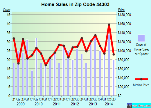
Recent home sales, price trends, and home value evaluator powered by Onboard Informatics
© 2024 Onboard Informatics. Information is deemed reliable but not guaranteed.
© 2024 Onboard Informatics. Information is deemed reliable but not guaranteed.
Some parts © 2024 Advameg, Inc.
Compilation, repackaging, or reproduction prohibited. Users are forewarned that it is incumbent upon them to verify information with the responsible state agency. Advameg, Inc. does not guarantee the data presented is up-to-date nor does it assume responsibility for updating it. Therefore any names, owners or addresses may have changed. Use of any information published here to contact the persons might be prohibited by the law.