Property valuation of W Thornton Street, Akron, OH: 529, 529, 532 & 534 #3, 538, 541, 546, 554, 565, 565, 565 (tax assessments)
Other nearby streets: Haynes Street  Howe Street (1)
Howe Street (2)
Snyder Street (1)
Snyder Street (2)
Howe Street (1)
Howe Street (2)
Snyder Street (1)
Snyder Street (2)
Howe Street (1)
Howe Street (2)
Snyder Street (1)
Snyder Street (2)
Listed properties vs overall distribution of properties in Akron, OH:
Advertisements
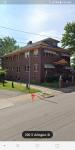
529 W Thornton Street
Akron, OH 44307
Find on map >>
Owner: STEWART AND CALHOUN FUNERAL HOME INC
Land value: $5,390
Total value for property: $5,390
Class: Commercial
Land use: Commercial Vacant Land
Land area: 3,920 square feet
Land depth factor: 1.00
Square footage: 3,920 square feet
Reason: Reappraisal
Assessments for tax year: 2009
Sale date: 11/04/1993
Old owner name: STEWART CALHOUN & BLACKCOMPANY INC
New owner name: STEWART & CALHOUN FUNERAL HOME INC
529 W Thornton Street
Akron, OH 44307
Find on map >>
Owner: STEWART CALHOUN & BLACKCOMPANY INC
Building value: $904,910
Land value: $31,150
Total value for property: $936,060
Class: Commercial
Land use: Funeral Homes
Land area: 11,325 square feet
Land depth factor: 1.00
Square footage: 11,326 square feet
Reason: Miscellaneous reasons
Assessments for tax year: 2009
532 & 534 W Thornton Street #3
Akron, OH 44307
Find on map >>
Owner: LISA DEPIPPO
Building value: $27,710
Land value: $10,190
Total value for property: $37,900
Class: Residential
Land use: Three Family Dwelling, Platted Lot
Living area: 1,984 square feet
Exterior wall: Frame
Style: 1 Fam + 2 Cv
Year property was built: 1900
Total number of rooms: 9
Number of bedrooms: 4
Number of full bathrooms: 3
Number of half bathrooms: 2
Total number of plumbing fixtures: 15
Basement: Full
Type of heating: Central
Fuel Type: Gas
Attic: No
Recreational room area: 730 square feet
Main ground floor area: 448 square feet
Condition: Fair
Replacement cost new value of additions: $81,330
Living area of additions: 1,088 square feet
Adjusted area: 450 square feet
Plumbing value: $10,000
Replacement cost new less depreciation value: $27,710
Adjusted replacement cost new less depreciation value: $27,710
Replacement cost new value: $143,940
Recreational Room Value: $5,500
Land area: 4,983 square feet
Land frontage: 56 feet
Land depth: 89 feet
Land depth table: 150 feet
Land depth factor: 0.77
Square footage: 4,984 square feet
Reason: Reappraisal
Assessments for tax year: 2009
Sales:
-
Sale date: 11/21/1996
Price: $18,500
Old owner name: CEYLA BELTON
New owner name: DAVID K BROMLEY
Validity: Valid
Source: Buyer
-
Sale date: 11/26/1996
Old owner name: DAVID K BROMLEY
New owner name: HILDA A BROMLEY
-
Sale date: 08/31/1999
Price: $28,400
Old owner name: HILDA A BROMLEY
New owner name: KATHLEEN MYERS TRUSTEE
Validity: Valid
-
Sale date: 03/21/2000
Price: $22,000
Old owner name: KATHLEEN MYERS TRUSTEE
New owner name: JOSEPH PISCAZZI
Validity: Multiple Parcel Sale
-
Sale date: 11/27/2000
Price: $107,000
Old owner name: JOSEPH PISCAZZI
New owner name: MITCHELL GINGRICH
Validity: Valid
-
Sale date: 11/22/2002
Price: $40,000
Old owner name: MITCHELL GINGRICH
New owner name: MORTGAGE CORPORATION EMC
Validity: Foreclosure/Sheriff Sale
-
Sale date: 08/19/2004
Price: $12,000
Old owner name: MORTGAGE CORPORATION EMC
New owner name: LISA DEPIPPO
Validity: Mortgage/lender
Source: Conveyance
538 W Thornton Street
Akron, OH 44307
Find on map >>
Owner: WILLIAM E CALHOUN
Building value: $29,710
Land value: $12,840
Total value for property: $42,550
Class: Residential
Land use: Single Family Dwelling, Platted Lot
Living area: 750 square feet
Exterior wall: Frame
Style: Ranch
Year property was built: 1909
Total number of rooms: 5
Number of bedrooms: 3
Number of full bathrooms: 1
Total number of plumbing fixtures: 5
Basement: None
Type of heating: Central
Fuel Type: Gas
Attic: No
Main ground floor area: 750 square feet
Condition: Fair
Adjusted area: 750 square feet
Replacement cost new less depreciation value: $9,590
Adjusted replacement cost new less depreciation value: $9,590
Replacement cost new value: $25,850
Land area: 7,888 square feet
Land frontage: 58 feet
Land depth: 136 feet
Land depth table: 150 feet
Land depth factor: 0.95
Square footage: 7,888 square feet
Reason: Reappraisal
Assessments for tax year: 2009
Sales:
-
Sale date: 09/11/1991
Price: $21,000
Old owner name: GEORGE J MUELLER & MARY J MUELLER
New owner name: NETTIE L MILLER
Validity: Valid
Source: Buyer
-
Sale date: 01/29/1999
Price: $30,000
Old owner name: WILLIAM E CALHOUN & MARGARET A CALHOUN
New owner name: WILLIAM E CALHOUN & MARGARET A CALHOUN
Validity: Valid
541 W Thornton Street
Akron, OH
Find on map >>
Owner: WILLIAM E CALHOUN & MARGARET A CALHOUN
Land value: $8,380
Total value for property: $8,380
Class: Commercial
Land use: Commercial Vacant Land
Land area: 3,049 square feet
Land depth factor: 1.00
Square footage: 3,049 square feet
Reason: Reappraisal
Assessments for tax year: 2009
Sales:
-
Sale date: 09/12/1994
Old owner name: STEWART CALHOUN & BLACK CO INC
New owner name: STEWART & FUNERAL HOME CALHOUN
-
Sale date: 03/02/1995
Old owner name: STEWART & CALHOUN FUNERAL HOME INC
New owner name: WILLIAM E CALHOUN & MARGARET A CALHOUN
546 W Thornton Street
Akron, OH
Find on map >>
Owner: WILLIAM E CALHOUN & MARGARET A CALHOUN
Building value: $20,310
Land value: $11,470
Total value for property: $31,780
Class: Commercial
Land use: Other Retail Structures
Land area: 8,346 square feet
Land depth factor: 1.00
Square footage: 8,344 square feet
Reason: Reappraisal
Assessments for tax year: 2009
Sale date: 01/29/1999
Price: $30,000
Old owner name: WILLIAM E CALHOUN & MARGARET A CALHOUN
New owner name: WILLIAM E CALHOUN & MARGARET A CALHOUN
Validity: Valid
554 W Thornton Street
Akron, OH 44307
Find on map >>
Owner: NAEL ABBAS & MAJED AWADALLAH ABBAS
Building value: $145,390
Land value: $37,630
Total value for property: $183,020
Class: Commercial
Land use: Supermarkets
Land area: 13,682 square feet
Land depth factor: 1.00
Square footage: 13,682 square feet
Reason: Reappraisal
Assessments for tax year: 2009
565 W Thornton Street
Akron, OH 44307
Find on map >>
Owner: LIGHTHOUSE BAPTIST CHURCH
Building value: $150,650
Land value: $22,880
Total value for property: $173,530
Class: Exempt
Land use: Churches Etc Public Worship Prive
Land area: 8,319 square feet
Land depth factor: 1.00
Square footage: 8,320 square feet
Reason: Reappraisal
Assessments for tax year: 2009
Sale date: 08/10/2001
Price: $85,000
Old owner name: ST PAUL MISSIONARY BAPTIST CHURCH
New owner name: LIGHTHOUSE BAPTIST CHURCH
Validity: Valid
565 W Thornton Street
Akron, OH 44307
Find on map >>
Owner: LIGHTHOUSE BAPTIST CHURCH
Land value: $10,290
Total value for property: $10,290
Class: Exempt
Land use: Churches Etc Public Worship Prive
Land area: 5,301 square feet
Land frontage: 50 feet
Land depth: 106 feet
Land depth table: 150 feet
Land depth factor: 0.83
Square footage: 5,300 square feet
Reason: Reappraisal
Assessments for tax year: 2009
Sale date: 08/10/2001
Price: $85,000
Old owner name: ST PAUL MISSIONARY BAPTIST CHURCH
New owner name: LIGHTHOUSE BAPTIST CHURCH
Validity: Valid
565 W Thornton Street
Akron, OH 44307
Find on map >>
Owner: LIGHTHOUSE BAPTIST CHURCH
Land value: $7,020
Total value for property: $7,020
Class: Exempt
Land use: Churches Etc Public Worship Prive
Land area: 5,105 square feet
Land depth factor: 1.00
Square footage: 5,104 square feet
Reason: Reappraisal
Assessments for tax year: 2009
Sale date: 08/10/2001
Price: $85,000
Old owner name: ST PAUL MISSIONARY BAPTIST CHURCH
New owner name: LIGHTHOUSE BAPTIST CHURCH
Validity: Valid
Other nearby streets: Haynes Street
Howe Street (1)
Howe Street (2)
Snyder Street (1)
Snyder Street (2)
Howe Street (1)
Howe Street (2)
Snyder Street (1)
Snyder Street (2)

Recent posts about Akron, Ohio on our local forum with over 2,400,000 registered users. Akron is mentioned 2,692 times on our forum:
 | possible move to Akron Ohio (5 replies) |
| Safe/good parts of Akron? (4 replies) |
| Tell me about Akron area (17 replies) |
| Relationship between Akron and Cleveland (14 replies) |
| Akron vs Dayton? (4 replies) |
| Safe & affordable places in Akron for young woman (5 replies) |
Settings
X

Recently Added Photos

Akron, OH
Akron, OH

Akron, OH

Akron, OH

Akron, OH
Akron, OH

Akron, OH

Akron, OH

Akron, OH

Akron, OH

Akron, OH

Akron, OH
Request disassociating your name from street-level assessment address

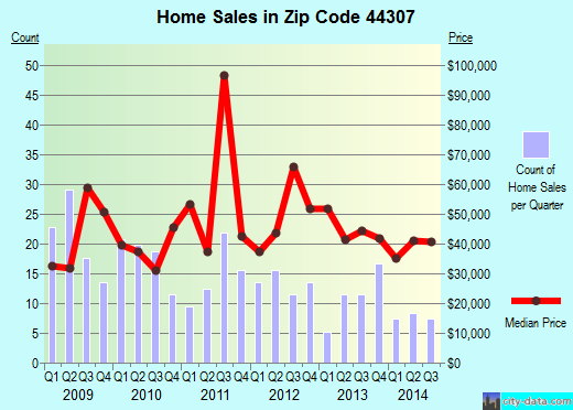
Recent home sales, price trends, and home value evaluator powered by Onboard Informatics
© 2024 Onboard Informatics. Information is deemed reliable but not guaranteed.
© 2024 Onboard Informatics. Information is deemed reliable but not guaranteed.
Some parts © 2024 Advameg, Inc.
Compilation, repackaging, or reproduction prohibited. Users are forewarned that it is incumbent upon them to verify information with the responsible state agency. Advameg, Inc. does not guarantee the data presented is up-to-date nor does it assume responsibility for updating it. Therefore any names, owners or addresses may have changed. Use of any information published here to contact the persons might be prohibited by the law.