Property valuation of W Summit Street, Barberton, OH: 191, 191, 197, 197, 205, 217, 223, 229, 235, 291 (tax assessments)
Other nearby streets: Lloyd Street (1)  Lloyd Street (2)
Lloyd Street (3)
Parker Avenue (1)
Parker Avenue (2)
Lloyd Street (2)
Lloyd Street (3)
Parker Avenue (1)
Parker Avenue (2)
Lloyd Street (2)
Lloyd Street (3)
Parker Avenue (1)
Parker Avenue (2)
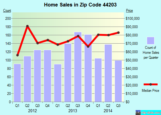
Listed properties vs overall distribution of properties in Barberton, OH:
Advertisements
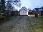
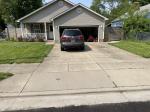
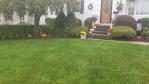
191 W Summit Street
Barberton, OH 44203
Find on map >>
Owner: RONALD MCVANEY
Land value: $2,090
Total value for property: $2,090
Class: Residential
Land use: Residential, Vacant Land, Lot
Land area: 749 square feet
Land frontage: 5 feet
Land depth: 150 feet
Land depth table: 150 feet
Land depth factor: 1.00
Square footage: 750 square feet
Reason: Reappraisal
Assessments for tax year: 2009
Sale date: 07/19/2001
Price: $84,500
Old owner name: BETTE B AND ELIZABETH B CURRANS
New owner name: RONALD MCVANEY
Validity: Valid
191 W Summit Street
Barberton, OH 44203
Find on map >>
Owner: RONALD MCVANEY
Building value: $61,900
Land value: $18,750
Total value for property: $80,650
Class: Residential
Land use: Single Family Dwelling, Platted Lot
Living area: 1,142 square feet
Exterior wall: Aluminum/vinyl
Style: Cape Cod
Year property was built: 1951
Total number of rooms: 5
Number of bedrooms: 3
Number of full bathrooms: 1
Total number of plumbing fixtures: 5
Basement: Full
Type of heating: Central air condition
Fuel Type: Gas
Attic: Full finished
Recreational room area: 408 square feet
Main ground floor area: 816 square feet
Condition: Good
Adjusted area: 820 square feet
Attic value: $13,000
Heat/air value: $1,900
Replacement cost new less depreciation value: $58,780
Adjusted replacement cost new less depreciation value: $58,780
Replacement cost new value: $95,190
Recreational Room Value: $3,100
Land area: 7,501 square feet
Land frontage: 50 feet
Land depth: 150 feet
Land depth table: 150 feet
Land depth factor: 1.00
Square footage: 7,500 square feet
Reason: Miscellaneous reasons
Assessments for tax year: 2009
Sale date: 07/19/2001
Price: $84,500
Old owner name: BETTE B AND ELIZABETH B CURRANS
New owner name: RONALD MCVANEY
Validity: Valid
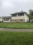
197 W Summit Street
Barberton, OH 44203
Find on map >>
Owner: DANIEL J AND LESLIE K JOHNSON
Building value: $44,690
Land value: $18,750
Total value for property: $63,440
Class: Residential
Land use: Single Family Dwelling, Platted Lot
Living area: 1,024 square feet
Exterior wall: Aluminum/vinyl
Style: Ranch
Year property was built: 1951
Total number of rooms: 5
Number of bedrooms: 2
Number of full bathrooms: 1
Total number of plumbing fixtures: 5
Basement: None
Type of heating: Central air condition
Fuel Type: Gas
Attic: No
Main ground floor area: 1,024 square feet
Condition: Average
Replacement cost new value of additions: $1,140
Adjusted area: 1,020 square feet
Heat/air value: $2,180
Replacement cost new less depreciation value: $44,690
Adjusted replacement cost new less depreciation value: $44,690
Replacement cost new value: $83,680
Land area: 7,501 square feet
Land frontage: 50 feet
Land depth: 150 feet
Land depth table: 150 feet
Land depth factor: 1.00
Square footage: 7,500 square feet
Reason: Reappraisal
Assessments for tax year: 2009
197 W Summit Street
Barberton, OH 44203
Find on map >>
Owner: DANIEL J AND LESLIE K JOHNSON
Building value: $6,880
Land value: $7,130
Total value for property: $14,010
Class: Residential
Land use: Other Residential
Land area: 3,750 square feet
Land frontage: 25 feet
Land depth: 150 feet
Land depth table: 150 feet
Land depth factor: 1.00
Square footage: 3,750 square feet
Reason: Reappraisal
Assessments for tax year: 2009
205 W Summit Street
Barberton, OH 44203
Find on map >>
Owner: RUSSEL R PRICE SR
Building value: $39,210
Land value: $18,750
Total value for property: $57,960
Class: Residential
Land use: Single Family Dwelling, Platted Lot
Living area: 1,048 square feet
Exterior wall: Aluminum/vinyl
Style: Colonial
Year property was built: 1926
Total number of rooms: 5
Number of bedrooms: 2
Number of full bathrooms: 1
Total number of plumbing fixtures: 5
Basement: Full
Type of heating: Central
Fuel Type: Gas
Attic: No
Main ground floor area: 390 square feet
Condition: Fair
Replacement cost new value of additions: $23,560
Living area of additions: 268 square feet
Adjusted area: 390 square feet
Replacement cost new less depreciation value: $36,930
Adjusted replacement cost new less depreciation value: $36,930
Replacement cost new value: $101,450
Land area: 7,501 square feet
Land frontage: 50 feet
Land depth: 150 feet
Land depth table: 150 feet
Land depth factor: 1.00
Square footage: 7,500 square feet
Reason: Reappraisal
Assessments for tax year: 2009
217 W Summit Street
Barberton, OH 44203
Find on map >>
Owner: CORTNEY L BISHOP
Building value: $46,020
Land value: $18,750
Total value for property: $64,770
Class: Residential
Land use: Single Family Dwelling, Platted Lot
Living area: 1,264 square feet
Exterior wall: Frame
Style: Colonial
Year property was built: 1920
Total number of rooms: 6
Number of bedrooms: 3
Number of full bathrooms: 1
Total number of plumbing fixtures: 5
Basement: Full
Type of heating: Central
Fuel Type: Gas
Attic: No
Main ground floor area: 560 square feet
Condition: Average
Replacement cost new value of additions: $8,810
Living area of additions: 144 square feet
Adjusted area: 560 square feet
Replacement cost new less depreciation value: $46,020
Adjusted replacement cost new less depreciation value: $46,020
Replacement cost new value: $103,290
Land area: 7,501 square feet
Land frontage: 50 feet
Land depth: 150 feet
Land depth table: 150 feet
Land depth factor: 1.00
Square footage: 7,500 square feet
Reason: Reappraisal
Assessments for tax year: 2009
Sales:
-
Sale date: 04/07/2003
Price: $50,000
Old owner name: JOHN W GRIFFITHS
New owner name: DAVID M FORSHEE & DENISE L FORSHEE
Validity: Valid
-
Sale date: 07/13/2004
Price: $69,900
Old owner name: DAVID M FORSHEE & DENISE L FORSHEE
New owner name: CORTNEY L BISHOP
Validity: Valid
Source: Conveyance
223 W Summit Street
Barberton, OH 44203
Find on map >>
Owner: LESTER R GRAY
Building value: $53,360
Land value: $18,750
Total value for property: $72,110
Class: Residential
Land use: Single Family Dwelling, Platted Lot
Living area: 1,208 square feet
Exterior wall: Aluminum/vinyl
Style: Single Family
Year property was built: 1920
Total number of rooms: 7
Number of bedrooms: 3
Number of family rooms: 1
Number of full bathrooms: 1
Total number of plumbing fixtures: 5
Basement: Full
Type of heating: Central
Fuel Type: Gas
Attic: No
Main ground floor area: 520 square feet
Condition: Average
Replacement cost new value of additions: $42,600
Living area of additions: 428 square feet
Adjusted area: 520 square feet
Replacement cost new less depreciation value: $52,530
Adjusted replacement cost new less depreciation value: $52,530
Replacement cost new value: $117,910
Land area: 7,501 square feet
Land frontage: 50 feet
Land depth: 150 feet
Land depth table: 150 feet
Land depth factor: 1.00
Square footage: 7,500 square feet
Reason: Miscellaneous reasons
Assessments for tax year: 2009
229 W Summit Street
Barberton, OH 44203
Find on map >>
Owner: WALTER S MATHEWS
Building value: $56,340
Land value: $18,750
Total value for property: $75,090
Class: Residential
Land use: Single Family Dwelling, Platted Lot
Living area: 1,972 square feet
Exterior wall: Aluminum/vinyl
Style: Colonial
Year property was built: 1903
Total number of rooms: 8
Number of bedrooms: 4
Number of family rooms: 1
Number of full bathrooms: 1
Number of half bathrooms: 1
Total number of plumbing fixtures: 7
Basement: Full
Type of heating: Central air condition
Fuel Type: Gas
Attic: No
Recreational room area: 140 square feet
Number of wood fireplace openings: 2
Number of wood fireplace stacks: 2
Main ground floor area: 863 square feet
Condition: Average
Replacement cost new value of additions: $22,030
Living area of additions: 246 square feet
Adjusted area: 860 square feet
Heat/air value: $2,930
Plumbing value: $2,000
Replacement cost new less depreciation value: $56,340
Adjusted replacement cost new less depreciation value: $56,340
Replacement cost new value: $152,690
Recreational Room Value: $1,100
Wood Fireplace Value: $6,000
Land area: 7,501 square feet
Land frontage: 50 feet
Land depth: 150 feet
Land depth table: 150 feet
Land depth factor: 1.00
Square footage: 7,500 square feet
Reason: 2 1/2 percent
Assessments for tax year: 2009
Sales:
-
Sale date: 07/09/1999
Old owner name: MOLLIE J SNYDER
New owner name: MOLLIE JANE BARNES & JACK BARNES
-
Sale date: 01/05/2001
Price: $86,900
Old owner name: MOLLIE JANE BARNES & JACK BARNES
New owner name: DANIEL S MCCRADY
Validity: Valid
-
Sale date: 06/01/2007
Price: $110,000
Old owner name: DANIEL S MCCRADY
New owner name: WALTER S MATHEWS
Validity: Valid
Source: Conveyance
235 W Summit Street
Barberton, OH 44203
Find on map >>
Owner: TODD M GOMEZ
Building value: $56,530
Land value: $18,750
Total value for property: $75,280
Class: Residential
Land use: Single Family Dwelling, Platted Lot
Living area: 1,728 square feet
Exterior wall: Aluminum/vinyl
Style: Colonial
Year property was built: 1910
Total number of rooms: 8
Number of bedrooms: 3
Number of full bathrooms: 2
Total number of plumbing fixtures: 8
Basement: Full
Type of heating: Central air condition
Fuel Type: Gas
Attic: No
Main ground floor area: 624 square feet
Condition: Average
Replacement cost new value of additions: $31,180
Living area of additions: 480 square feet
Adjusted area: 620 square feet
Heat/air value: $2,420
Plumbing value: $3,000
Replacement cost new less depreciation value: $56,530
Adjusted replacement cost new less depreciation value: $56,530
Replacement cost new value: $133,640
Land area: 7,501 square feet
Land frontage: 50 feet
Land depth: 150 feet
Land depth table: 150 feet
Land depth factor: 1.00
Square footage: 7,500 square feet
Reason: Reappraisal
Assessments for tax year: 2009
Sales:
-
Sale date: 07/26/1996
Price: $71,500
Old owner name: WANETA JEAN PURDY
New owner name: JACQUELINE C SPINELLI & TODD M GOMEZ
Validity: Valid
Source: Buyer
-
Sale date: 09/12/2002
Old owner name: JACQUELINE C SPINELLI & TODD M GOMEZ
New owner name: TODD M GOMEZ
291 W Summit Street
Barberton, OH 44203
Find on map >>
Owner: BOARD OF EDUCATION BARBERTON
Building value: $1,687,330
Land value: $111,380
Total value for property: $1,798,710
Class: Exempt
Land use: Exempt Property Owned By Bd Of Educ.
Land area: 87,120 square feet
Land depth factor: 1.00
Square footage: 87,120 square feet
Reason: Reappraisal
Assessments for tax year: 2009
Other nearby streets: Lloyd Street (1)
Lloyd Street (2)
Lloyd Street (3)
Parker Avenue (1)
Parker Avenue (2)
Lloyd Street (2)
Lloyd Street (3)
Parker Avenue (1)
Parker Avenue (2)

Recent posts about Barberton, Ohio on our local forum with over 2,400,000 registered users. Barberton is mentioned 150 times on our forum:
 | What are your thoughts on the Norton/Barberton area? (1 reply) |
| Lakemore or Barberton (8 replies) |
| Looking for friends of Doug Brown (0 replies) |
| Barberton school district...and open enrollment (0 replies) |
| Looking for a good local cheese/dairy farm. (3 replies) |
| No more Barberton Gardens? (0 replies) |
Settings
X

Recently Added Photos

Barberton, OH

Barberton, OH
Middletown, OH
Middletown, OH
Lisbon, OH
Parma, OH
Cuyahoga Falls, OH

Rocky River, OH
Mayfield Heights, OH

Rocky River, OH

Garfield Heights, OH

Harrison, OH
Request disassociating your name from street-level assessment address

Recent home sales, price trends, and home value evaluator powered by Onboard Informatics
© 2024 Onboard Informatics. Information is deemed reliable but not guaranteed.
© 2024 Onboard Informatics. Information is deemed reliable but not guaranteed.
Some parts © 2024 Advameg, Inc.
Compilation, repackaging, or reproduction prohibited. Users are forewarned that it is incumbent upon them to verify information with the responsible state agency. Advameg, Inc. does not guarantee the data presented is up-to-date nor does it assume responsibility for updating it. Therefore any names, owners or addresses may have changed. Use of any information published here to contact the persons might be prohibited by the law.