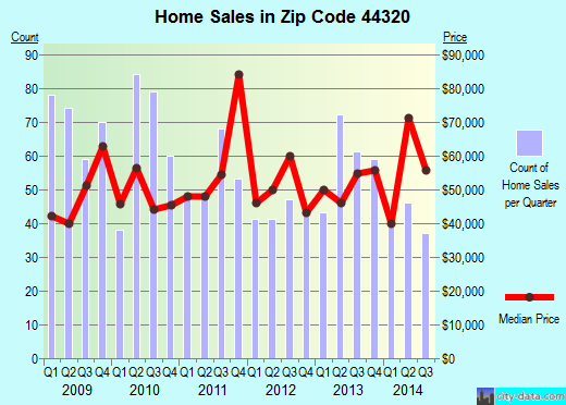
Property valuation of Stoner Street, Akron, OH (tax assessments)
Other nearby streets: Grace Avenue  Slosson Street (1)
Slosson Street (2)
Stoner Avenue
Stoner Street
Slosson Street (1)
Slosson Street (2)
Stoner Avenue
Stoner Street
Slosson Street (1)
Slosson Street (2)
Stoner Avenue
Stoner Street
Listed properties vs overall distribution of properties in Akron, OH:
Advertisements
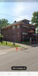
Stoner Street
Akron, OH 44320
Find on map >>
Owner: CLARENCE COKER
Land value: $2,700
Total value for property: $2,700
Class: Residential
Land use: Residential, Vacant Land, Lot
Land area: 5,401 square feet
Land frontage: 45 feet
Land depth: 120 feet
Land depth table: 150 feet
Land depth factor: 0.89
Square footage: 5,400 square feet
Reason: Reappraisal
Assessments for tax year: 2009
Sales:
-
Sale date: 10/25/1993
Old owner name: CLARENCE COKER & LOLA B COKER
New owner name: JIM NELSON
-
Sale date: 02/09/1994
Price: $400
Old owner name: JIM NELSON
New owner name: CLARENCE COKER & LOLA COKER
Validity: Valid
Source: Buyer
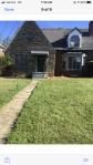
Stoner Street
Akron, OH 44320
Find on map >>
Owner: CRAWFORD R J & STATE OF OHIO
Land value: $370
Total value for property: $370
Class: Exempt
Land use: Exempt Forfeited Land
Land area: 823 square feet
Land frontage: 33 feet
Land depth: 25 feet
Land depth table: 150 feet
Land depth factor: 1.00
Square footage: 825 square feet
Reason: Reappraisal
Assessments for tax year: 2009
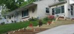
Stoner Street
Akron, OH 44320
Find on map >>
Owner: JOSEPH L HUMPHREY
Land value: $880
Total value for property: $880
Class: Residential
Land use: Residential, Vacant Land, Lot
Land area: 518 square feet
Land frontage: 40 feet
Land depth: 13 feet
Land depth table: 150 feet
Land depth factor: 0.26
Square footage: 520 square feet
Reason: Reappraisal
Assessments for tax year: 2009
Stoner Street
Akron, OH 44320
Find on map >>
Owner: GEORGE KING
Land value: $3,850
Total value for property: $3,850
Class: Residential
Land use: Residential, Vacant Land, Lot
Land area: 3,280 square feet
Land frontage: 41 feet
Land depth: 80 feet
Land depth table: 150 feet
Land depth factor: 0.73
Square footage: 3,280 square feet
Reason: Reappraisal
Assessments for tax year: 2009
Stoner Street
Akron, OH 44320
Find on map >>
Owner: CITY OF AKRON
Land value: $15,760
Total value for property: $15,760
Class: Exempt
Land use: Exempt Property Owned By Municipals
Land area: 6,464 square feet
Land frontage: 61 feet
Land depth: 106 feet
Land depth table: 150 feet
Land depth factor: 0.83
Square footage: 6,464 square feet
Reason: Reappraisal
Assessments for tax year: 2009
Sale date: 08/13/2003
Old owner name: ROSIE HAMAD
New owner name: CITY OF AKRON
Stoner Street
Akron, OH 44320
Find on map >>
Owner: PATRICIA A HOUGLAN
Land value: $13,090
Total value for property: $13,090
Class: Residential
Land use: Residential, Vacant Land, Lot
Land area: 3,598 square feet
Land frontage: 40 feet
Land depth: 90 feet
Land depth table: 150 feet
Land depth factor: 0.77
Square footage: 3,600 square feet
Reason: Reappraisal
Assessments for tax year: 2009
Stoner Street
Akron, OH 44320
Find on map >>
Owner: OHIO EDISON CO
Land value: $2,400
Total value for property: $2,400
Class: Commercial
Land use: Comm Ld & Impro Own By Pub Uti Th Rail
Land area: 2,613 square feet
Land depth factor: 1.00
Square footage: 2,614 square feet
Reason: Reappraisal
Assessments for tax year: 2009
Stoner Street
Akron, OH 44320
Find on map >>
Owner: OHIO EDISON CO
Building value: $2,180
Land value: $6,400
Total value for property: $8,580
Class: Commercial
Land use: Comm Ld & Impro Own By Pub Uti Th Rail
Land area: 6,969 square feet
Land depth factor: 1.00
Square footage: 6,970 square feet
Reason: Reappraisal
Assessments for tax year: 2009
Stoner Street
Akron, OH 44320
Find on map >>
Owner: OHIO EDISON CO
Land value: $4,000
Total value for property: $4,000
Class: Commercial
Land use: Comm Ld & Impro Own By Pub Uti Th Rail
Land area: 4,356 square feet
Land depth factor: 1.00
Square footage: 4,356 square feet
Reason: Reappraisal
Assessments for tax year: 2009
Stoner Street
Akron, OH 44320
Find on map >>
Owner: MONROE EVANS
Land value: $1,100
Total value for property: $1,100
Class: Residential
Land use: Residential, Vacant Land, Lot
Land area: 1,681 square feet
Land frontage: 14 feet
Land depth: 120 feet
Land depth table: 150 feet
Land depth factor: 0.89
Square footage: 1,680 square feet
Reason: Reappraisal
Assessments for tax year: 2009
Other nearby streets: Grace Avenue
Slosson Street (1)
Slosson Street (2)
Stoner Avenue
Stoner Street
Slosson Street (1)
Slosson Street (2)
Stoner Avenue
Stoner Street

Recent posts about Akron, Ohio on our local forum with over 2,400,000 registered users. Akron is mentioned 2,692 times on our forum:
 | possible move to Akron Ohio (5 replies) |
| Safe/good parts of Akron? (4 replies) |
| Tell me about Akron area (17 replies) |
| Relationship between Akron and Cleveland (14 replies) |
| Akron vs Dayton? (4 replies) |
| Safe & affordable places in Akron for young woman (5 replies) |
Settings
X

Recently Added Photos

Akron, OH
Akron, OH
Akron, OH

Akron, OH
Akron, OH
Akron, OH

Akron, OH

Akron, OH

Akron, OH

Akron, OH

Akron, OH

Akron, OH
Request disassociating your name from street-level assessment address

Recent home sales, price trends, and home value evaluator powered by Onboard Informatics
© 2024 Onboard Informatics. Information is deemed reliable but not guaranteed.
© 2024 Onboard Informatics. Information is deemed reliable but not guaranteed.
Some parts © 2024 Advameg, Inc.
Compilation, repackaging, or reproduction prohibited. Users are forewarned that it is incumbent upon them to verify information with the responsible state agency. Advameg, Inc. does not guarantee the data presented is up-to-date nor does it assume responsibility for updating it. Therefore any names, owners or addresses may have changed. Use of any information published here to contact the persons might be prohibited by the law.