Property valuation of State Street, Akron, OH (tax assessments)
Other nearby streets: Broadway Street  E State Street (1)
E State Street (2)
State Street (1)
State Street (2)
E State Street (1)
E State Street (2)
State Street (1)
State Street (2)
E State Street (1)
E State Street (2)
State Street (1)
State Street (2)
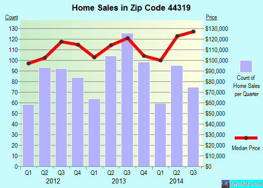
Listed properties vs overall distribution of properties in Akron, OH:
Advertisements
State Street
Akron, OH
Find on map >>
Owner: JOHN C SIMS
Land value: $8,440
Total value for property: $8,440
Class: Residential
Land use: Residential, Vacant Land, Lot
Land area: 2,813 square feet
Land frontage: 44 feet
Land depth: 64 feet
Land depth table: 150 feet
Land depth factor: 0.66
Square footage: 2,816 square feet
Reason: Reappraisal
Assessments for tax year: 2009
State Street
Akron, OH
Find on map >>
Owner: LIVING WATER FELLOWSHIP INC
Land value: $34,710
Total value for property: $34,710
Class: Exempt
Land use: Churches Etc Public Worship Prive
Land area: 43,560 square feet
Land depth factor: 1.00
Square footage: 43,560 square feet
Reason: Reappraisal
Assessments for tax year: 2009
State Street
Akron, OH
Find on map >>
Owner: RANDAL S WAGNER & DONNA J WAGNER
Land value: $450
Total value for property: $450
Class: Industrial
Land use: Industrial, Vacant Land
Land area: 1,742 square feet
Land depth factor: 1.00
Square footage: 1,742 square feet
Reason: Reappraisal
Assessments for tax year: 2009
Sale date: 01/14/2004
Old owner name: RANDAL S WAGNER & KIMBERLY M WAGNER & DONNA J WAGNER
New owner name: RANDAL S WAGNER & DONNA J WAGNER
State Street
Akron, OH
Find on map >>
Owner: MERRILEE ANTHE TRUSTEE
Land value: $17,110
Total value for property: $17,110
Class: Residential
Land use: Residential, Vacant Land, Lot
Land area: 135,471 square feet
Land depth factor: 1.00
Square footage: 135,472 square feet
Reason: Reappraisal
Assessments for tax year: 2009
Sales:
-
Sale date: 11/04/1993
Old owner name: JAMES C AND MERRILEE ANTHE
New owner name: MERRILEE ANTHE
-
Sale date: 05/02/2000
Old owner name: MERRILEE ANTHE
New owner name: JAMES C ANTHE & MERRILEE ANTHE
-
Sale date: 06/03/2004
Old owner name: JAMES C ANTHE & MERRILEE ANTHE
New owner name: MERRILEE ANTHE TRUSTEE
State Street
Akron, OH 44319
Find on map >>
Owner: STATE OF OHIO & COX VIRGINIA
Land value: $11,870
Total value for property: $11,870
Class: Exempt
Land use: Exempt Forfeited Land
Land area: 1,829 square feet
Land frontage: 6 feet
Land depth: 305 feet
Land depth table: 150 feet
Land depth factor: 1.20
Square footage: 1,830 square feet
Reason: Reappraisal
Assessments for tax year: 2009
State Street
Akron, OH
Find on map >>
Owner: ROBERT J KING
Land value: $5,100
Total value for property: $5,100
Class: Commercial
Land use: Commercial Vacant Land
Land area: 7,840 square feet
Land depth factor: 1.00
Square footage: 7,840 square feet
Reason: Reappraisal
Assessments for tax year: 2009
Sales:
Akron, OH
Find on map >>
Owner: ROBERT J KING
Land value: $5,100
Total value for property: $5,100
Class: Commercial
Land use: Commercial Vacant Land
Land area: 7,840 square feet
Land depth factor: 1.00
Square footage: 7,840 square feet
Reason: Reappraisal
Assessments for tax year: 2009
Sales:
-
Sale date: 11/17/1997
Price: $325,000
Old owner name: STARINKI WILLIAM INC
New owner name: DENNIS J KING & ROBERT J KING
Validity: Multiple Parcel Sale
-
Sale date: 03/26/2007
Price: $130,070
Old owner name: DENNIS J KING & ROBERT J KING
New owner name: ROBERT J KING
Validity: Part Interest
State Street
Akron, OH
Find on map >>
Owner: AKRON BARBERTON CLUSTER RAILWAY CO
Total value for property: $0
Class: Utilities
Land use: Railroad Real Prop Used In Operation
Land area: 78,843 square feet
Land depth factor: 1.00
Square footage: 78,844 square feet
Reason: Miscellaneous reasons
Assessments for tax year: 2009
Sale date: 05/18/2001
Old owner name: AKRON BARBERTON CLUSTER RAILWAY CO
New owner name: AKRON BARBERTON CLUSTER RAILWAY CO
State Street
Akron, OH
Find on map >>
Owner: AKRON BARBERTON CLUSTER RAILWAY CO
Total value for property: $0
Class: Utilities
Land use: Railroad Real Prop Used In Operation
Land area: 250,034 square feet
Land depth factor: 1.00
Square footage: 250,034 square feet
Reason: Property split/combine
Assessments for tax year: 2009
State Street
Akron, OH
Find on map >>
Owner: AKRON CSXJUNCTION BR B CHICAGO & O CHICAGO
Total value for property: $0
Class: Utilities
Land use: Railroad Real Prop Used In Operation
Land area: 160,736 square feet
Land depth factor: 1.00
Square footage: 160,736 square feet
Reason: Miscellaneous reasons
Assessments for tax year: 2009
State Street
Akron, OH 44319
Find on map >>
Owner: ALEX N STAVARZ & KAREN E STAVARZ
Building value: $26,580
Land value: $103,400
Total value for property: $129,980
Class: Commercial
Land use: Other Retail Structures
Land area: 43,560 square feet
Land depth factor: 1.00
Square footage: 43,560 square feet
Reason: Board of revision
Assessments for tax year: 2009
Sales:
-
Sale date: 12/23/1997
Old owner name: FAMILY REVOCABLE LIVING STAVARZ TRUST
New owner name: ALEX L STAVARZ & ELSIE M STAVARZ TRUSTEES
-
Sale date: 02/03/1998
Old owner name: ALEX L STAVARZ & ELSIE M STAVARZ TRUSTEES
New owner name: ALEX N STAVARZ & KAREN E STAVARZ
-
Sale date: 02/03/1998
Old owner name: ALEX L STAVARZ & ELSIE M STAVARZ TRUSTEES
New owner name: ALEX L STAVARZ & ELSIE M STAVARZ TRUSTEES
Other nearby streets: Broadway Street
E State Street (1)
E State Street (2)
State Street (1)
State Street (2)
E State Street (1)
E State Street (2)
State Street (1)
State Street (2)

Recent posts about Akron, Ohio on our local forum with over 2,400,000 registered users. Akron is mentioned 2,692 times on our forum:
 | possible move to Akron Ohio (5 replies) |
| Safe/good parts of Akron? (4 replies) |
| Tell me about Akron area (17 replies) |
| Relationship between Akron and Cleveland (14 replies) |
| Akron vs Dayton? (4 replies) |
| Safe & affordable places in Akron for young woman (5 replies) |
Settings
X

Recently Added Photos

Akron, OH
Akron, OH
Akron, OH

Akron, OH
Akron, OH
Akron, OH

Akron, OH

Akron, OH

Akron, OH

Akron, OH

Akron, OH

Akron, OH
Request disassociating your name from street-level assessment address

Recent home sales, price trends, and home value evaluator powered by Onboard Informatics
© 2024 Onboard Informatics. Information is deemed reliable but not guaranteed.
© 2024 Onboard Informatics. Information is deemed reliable but not guaranteed.
Some parts © 2024 Advameg, Inc.
Compilation, repackaging, or reproduction prohibited. Users are forewarned that it is incumbent upon them to verify information with the responsible state agency. Advameg, Inc. does not guarantee the data presented is up-to-date nor does it assume responsibility for updating it. Therefore any names, owners or addresses may have changed. Use of any information published here to contact the persons might be prohibited by the law.